Right, time to finish the Vuelta off, I kind of lost track since there's only the one stage left. So in case you were all forgetting, we are looking at so far:
Stage 1: short TT in Casablanca
Stage 2: sprint in Rabat
Stage 3: bumpy finishing circuit in Tangier
Stage 4: puncheur finish after the Puerto del León
Stage 5: MTF at Cumbres Verdes after Sierra Nevada by its toughest side
Stage 6: sprint in Ciudad Real
Stage 7: 50km flat TT in Toledo
Stage 8: the classic Ávila finish
Stage 9: very long multi-mountain stage with a short final climb and descent finish in La Granja
Stage 10: sprint in Astorga
Stage 11: up and down all day to Vigo
Stage 12: sprint or echelons along the Galician coast
Stage 13: descent finish after Pozo de la Nieve and Monte Pousadoiro
Stage 14: very steep MTF at Acebo
Stage 15: MTT to Covadonga
Stage 16: transitional stage with a puncheur finish at Miranda de Ebro
Stage 17: flat stage with one small hill in Tarazona
Stage 18: sprint in Lleida
Stage 19: MTF in Andorra after a number of climbs
Stage 20: MTF at Coll de Pal after Pradell.
And now, it's time to finish it all off.
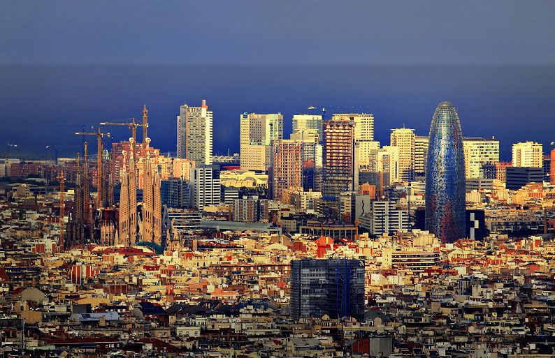
Stage 21: Barcelona - Barcelona, 29,9km (CRI)
No hay puertos de montaña.
When I started drawing this route up, the current blathering about Catalunya hadn't really started. Either way, my Vuelta finishes here. It takes slight inspiration from this year's Vuelta, although frankly an epilogue TT like that is a bit pointless; instead I have gone the Giro-style mid-length TT approach, long enough that if there is a tight battle for the GC there could be tension (like in 2012, say), and if there isn't, it's a nice parade for the winner without being a total washout (like in 2011, say). And Barcelona makes a good setting for it.
The TT starts on the finishing line of the old Montjuïc Park F1 circuit, close by what became the Olympic complex a little later on. That means that the first part of the course, which follows the old racing circuit as far as Carrer de Lleida. When that turns to the left, we continue straight on before a right onto
Avinguda del Paral-lel. We head to the bay and pass
L'Aquarium de Barcelona and head for
Parc de la Ciutadella and
Vila Olimpica. Next up on our list of sights, and for a final stage of a GT sure to please the ASO, is the
Arc de Triomf, followed shortly by
Plaça de Tetuan.
Rather than stay on Gran Via, however, we head back towards the coast, going via El Barri Gótic, and thereby passing the city's
iconic cathedral. This enables us to continue our Tour de Gaudi by passing
Palau Güell as we turn back away from the waterfront. The spectacular
Plaça de Catalunya is next, then the
university, as we head back towards the incredibly iconic
Plaça d'Espanya, gateway to Montjuïc.
We briefly rejoin the old racing circuit, but at a fork in the road, where the racing circuit (and the 2009 Tour stage) go left, we go right, to
Palau Sant Jordi, because the spirit of the Olympics is in us. We then head back down toward the coast and ride parallel to the southern face of the mountain, to give the riders a sense of foreboding, before handling the now familiar slopes up to the
Castell de Montjuïc, before a slight downhill roll ahead of the finish.
The finish will be as per the marathon in the 1992 Olympics,
a brutal slaughter of a course which you can see here. The important part for us is just from 2:13 to 2:16. Yes, we're heading through the front into the
Estadi Olímpic Lluís Companys for a final lap before finishing there. After all, there will be lots of room, hopefully they can get enough fans in to make it feel important, like when Basso won the Giro in 2010. If they can finish in the Plaza de Toros in Pamplona, they can finish here. It also has a bit of an old school Peace Race feel, finishing in an athletic stadium.
It does mean that there have been over 110km of ITT in four separate TTs in my Vuelta, but in my defence, 22 of those are Lagos de Covadonga. This route is quite balanced in my humble opinion.
Barcelona: