Race Design Thread

Page 192 - Get up to date with the latest news, scores & standings from the Cycling News Community.

w52

Aug 2, 2015
139
0
0
Tour of Macaronesia

Stage 7: Ponta Rincão - Praia (120,2 km)

After Tenerife and the Canary Islands, we leave Spanish territory and reach the last country of this adventure Cape Verde. The archipelago of Cape Verde is another portuguese discovery of the 15th century. The archipelago is formed by 10 different volcanic islands: : Santo Antão, São Vicente, Santa Luzia, São Nicolau, Sal, Boa Vista, Maio, Santiago, Fogo e Brava. Santiago is the main island, where is situated the capital Praia. In the island of Fogo is located the highest point of the islands at 2829m at the top of an active volcano that recently erupted, making a lot of damages to the population. Cape Verde gain independence from Portugal in 1975, after 25th April 1974. Nowadays is a democratic republic, with a very undeveloped economy and one of the poorest territories in Africa. Main economical activities are agriculture, the utilization of marine resources of the island and recently tourism is gaining some preponderance in the archipelago, being Sal and Boavista the most visited ones.

cabo-verde-mapa.gif


Stage 7, the first in Cape Verde will be held in the island of Santiago. Santiago is the biggest and most populated island of the archipelago and is the island where is located the capital Praia. The island of Santiago is the one with the best infrastructures, the airport was expanded in 2005, the national stadium and arena are there as well as the university of Cape Verde. Other known place is the infamous Tarrafal, a camp where the political opponents of Estado Novo (dictatorial regime of Portugal) were sent to forced labor.

Tarrafal bay
costa-santiago-727x401.jpg


Stage 7 is a short and mainly flat stage. It starts in Ponta Rincão and the first 30km are the trickiest ones, with a combo of three 3rd cat mountain passes, in Achada Gregório, Assomada and Serra da Malagueta. After the descent of the last climb riders will have a flat route with only small hills with low gradients. Stage finishes in Praia close to the national stadium.

maca_7.png


image.png


Ponta Rincão
ponta_rincao.jpg


Praia
cidade-da-praia.jpg
 
Stage 15: Villablino-Valle de Laciana - Pedrafita do Cebreiro, 197km

k2h17k.png


34iqtea.png


GPM:
Puerto del Connio (cat.1) 13,6km @ 5,7%
Chao de Arqueira (cat.2) 5,2km @ 8,6%
Alto de Valiña (cat.2) 5,7km @ 8,4%
Alto de Sete Carballos (cat.2) 10,2km @ 5,7%
Alto de A Pintinidoira (cat.1) 13,7km @ 5,2%
Alto de O Cebreiro (cat.1) 7,0km @ 8,7%

The penultimate Sunday of the race, and the final stage before the second rest day, this is a multi-mountain odyssey that takes in three provinces of Spain; beginning in León and passing through Asturias before heading into the Galician province of Lugo. That in itself is enough to be a bit impractical, I guess.

Villablino_Leon3.jpg


With around 10000 inhabitants, the mining town of Villablino is one of the few municipalities in this part of León large enough to host the Vuelta, however the UNESCO Biosphere reserve of the Valle de Laciana has some cycling history, once hosting its own one-day race (which the PRC guys tried to demonstrate could be resurrected), and seeing a number of Vuelta stages and stages of the Vuelta a León (and a Castilla y León) passing through its scenic centre. Not too far from Pola de Lena via the Puerto de Pajáres, it could serve as a useful stopping point for the Vuelta in the area. My stage immediately heads into Asturias via one of the two nearby lopsided passes (the other is Leitariegos), the Puerto del Cerredo. At 9km and 4% it is the hardest "no puntable" climb of my Vuelta, and should serve to ensure we get a decent breakaway with some strongish climbers in it. Especially as the descent from here gives way immediately to a period of downhill false flat before a cat.1 climb of the Puerto del Connio, often climbed preceding the Pozo de las Mujeres Muertas in the formerly traditional Vuelta a Asturias stage to Santuário del Acebo. It is fairly typical of the area, a lower average gradient belying some tougher slopes, verdant, pretty backdrops of trees and grass (Asturias being the rainiest part of Spain) and some lush, attractive mountainside aided by the relatively low altitude meaning the treeline is never surpassed.

P1130889%20(500%20x%20375).jpg


Descending from here, we head for the border between Asturias and Galicia, where we will spend the rest of the stage discovering something of these southeastern Galician climbs that the Vuelta tends not to investigate. To do so, we must cross the next climb of the day, the difficult hairpins of the Chao de Arqueira (that profile also includes the descent, which is inconsistent, multi-stepped and extremely technical. Ivan Basso already hates it). This is the last of the "warmup" climbs, if you like... the rest of the stage is pretty horrible, with meagre average gradients disguising some nasty, nasty slopes.

Os Sete Carballos is first, by its most inconsistent and punishing side, which I have divided up into two separate cat.2 climbs, first the Alto de Valiña, then five kilometres of rolling terrain (there are alternative versions that omit this in favour of a more gradual ascent to Sete Carballos), then a second extremely steep ramp that leads up to the final inconsistent up-and-down to the summit. Details are taken from APM user Marcos Folgueira, who is more of a masochist than I.

SeteCarballos-AFiosaporARibeira-Sevane73.gif


The first part of the ascent, to Valiña, is on perfectly wide roads that gradually get steeper to a max kilometre of 9%. The second part of the climb is much narrower and I can envision some riders suffering on this kind of slope at 10%, País Vasco style. The riders then rejoin the main road after 4km of that torture, for a false flat kilometre, than 1,5km at 6,5% to Serra da Cortella, then there's a couple of kilometres downhill before another couple of (steeper) kilometres uphill to the summit. 60km remain.

There's then a comparatively normal descent; it's on good quality roads and it's at relatively consistent gradients, which will come as a relief for the riders. The next climb, however, is similarly inconsistent to the last, being comprised of three separate ascents.

82c4521e.jpg


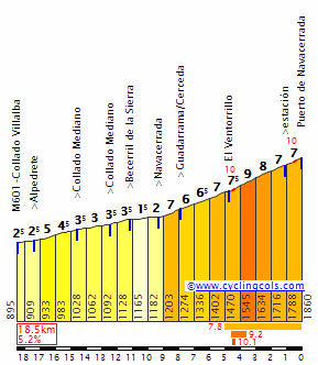
The view from A Pintinidoira is pretty good, as you can see. But getting there will be no fun, because though 14km at 5% doesn't sound too much (tiring, but not destructive), it really doesn't give you the real story. This is another La Marta or Croix de Fer (OK, it's not as tough as that). The profile shows what we're actually dealing with. It comprises a climb of 5km @ 8% (with the first 3km all at over 9%), three kilometres of rolling terrain, 2,5km @ 10% including a maximum gradient of 17%, a couple of kilometres of slight downhill, then a final ramp through the village itself at nearly 9% for just under a kilometre. Cresting at 29km to go, GC men who are not as adept at changing up and down the paces could struggle here; imagine Arrate, then as soon as they reach the end starting Montée Laurent Jalabert, then as soon as they reach the airport starting the Cauberg. That's about as close as I can get to explaining this one. It's very dangerous.

825849.jpg


The descent - which starts off fairly steep but grows more gradual - takes us through the eastern side of today's stage town of Pedrafita do Cebreiro, although we don't cross our finishing line; the route does not touch the final run-in. There is a separate line on the opposite side of town for an intermediate sprint here, before we head down the N-VI to Las Herrerías, crossing back into Castilla y León as we do. We are, however, finishing in Galicia, so we take a sharp right in that village, which takes us onto our final ascent, the mid-length but steep and nasty climb to O Cebreiro by its steepest side.

IMG_5813s-950x633.jpg


O+Cebreiro%5B1%5D.jpg


As you can see, apart from the comparative respite through La Laguna, this one is pretty relentless; a steepest kilometre at almost 11% and a max of 16%, this one crests just a short descent of 4,6km from the finishing line, and so even though the final kilometre of ascent is at 9,1%, the steep first four kilometres should cause some serious problems for a bunch which should really have been taken apart by Sete Carballos and A Pintinidoira's inconsistent gradients. This one's much less stop-start, and easier to get in a rhythm on, but helpers should be long gone by now for most people. Remember: the rest day is tomorrow, the first rest day was after stage 6 and yesterday's stage finished on an ESP category climb with 5km at 11,5% in the middle, so with the intermediate stages to Ronda, Yeste, Riaza and Cangas de Onis in the legs along with the MTFs at La Pandera and La Cobertoria, there will be some tired legs to exploit out there for those that dare.

The descent into Pedrafita do Cebreiro is fairly wide and comfortable and shouldn't cause anybody any real trouble - however it's not very long so if you want to negate any gaps created on the climb, you had better be Paolo Savoldelli.

12080314.jpg
 
Jul 26, 2015
145
0
0
Thats funny, when i see that Vuelta (and others previously), i get the feeling that you can have an extra-hard full route with stages filled only with cat.2 climbs without needing to have 10 MTF...
I indeed forgot to talk about the great uzbeks of the 80's. I already talked about Abdujaparov in my Tour, thats probably why. Shame on me.

STAGE 13 : Kokand - Fergana (ITT), 87km.

Finally, the first individual time trial of the race.
Of course, as we need to cover an awful lot of ground, we need to find the right place to do it, and today it is.

Its going to be long, of course, as climbers have plenty of occasions to get rid of the big engines along the race.
It will take place in the Fergana valley, a rare fertile place in an otherwise very difficult to live Central Asia, between mountains and deserts and is basically formed by the junction of two rivers into the Syr-Daria.
The valley is populated by a lot of different people which lived together there for centuries, until the soviet explosion put some tension in the relations.

Its a rare case of a city getting its name from the mountain chain next to it, rather than the other way around.

20120830122704_big.jpg

Fergana's door


Whereas the last cities visited have long and rich history, Fergana is recent, and the major city on the Silk Road was Margilon, just a few kilometers to the north, city that will be on the road of the time trial.

2-2.jpg

5-5.jpg


Anyway, this means a flat playground for riders today, with, and fatties must be competitive in order to get some time back.

duG9VjZ.png

V6ylzBJ.png
 

w52

Aug 2, 2015
139
0
0
Tour of Macaronesia

Stage 8: Ribeira Grande - Corda MTT (17.4km)


Today we finish this adventure in Macaronesia, with a MTT in the Island of Santo Antão. This is the second biggest island of Cape Verde, and will host the last stage and chance to conquer this race.

RibeiraGrandeStoAntao.jpg


The 8th stage is a 17,4km MTT that starts in the city of Ribeira Grande and will finish at the top of Estrada da Corda at 1435m high. The first km is flat an apetizer for the brutal climb that Corda represents. Almost 17km with a 8.4% gradient that will create big gaps between contenders and maybe change the final GC. Oh by the way this climb is cobbled...

Estrada-da-Corda.jpg


maca_8.png


Hope you enjoyed the overall race design. For me it was very fun to design this race, mainly the stage in Madeira and Tenerife, because there a lot of insane climbs to be used and i tried to choose original designs (i failed in Tenerife :p ). I also tried to make the rout well balanced with MTF, descent finishes, easier stages and also some ITT km. I also want to give credits to Lupetto for the post about Corda, it was being difficult to me design the last stage in Cape Verde and the post he made in the topic of the unknown climbs was the light that i needed.
 
The last two climbs of that stage 14, back to back, WOW! Bloody murder...have they been used in smaller races before? I'd be curious to see what kind of gaps resulted. And there's no way to hold back, looking ahead. Riders need to go all out. And boom, stage 15 is another toughy. I love it ;) .
 
Stage 16: Ponferrada - Estación de Esquí El Morredero, 24,0km (CRI)

2j2dn5k.png


1e1202.png


GPM:
Alto del Morredero (cat.E) 23,2km @ 5,2%

The first day after the rest day, and it's a mountain time trial.

Yes, I know I used the Estación de Esquí El Morredero as a finish in my third Vuelta, but that was on the descent from Llano de las Ovejas; this time I'm climbing up to the ski station.

vista-general-de-ponferrada.jpg


Ponferrada is of course a major cycling city, and plays host to several Vuelta stages as well as, of course, the 2014 World Championships, which were won by Michał Kwiatkowski a few seconds ahead of the chase. It is also a popular city with traceurs because of its location surrounded by the mountains of the Macizo Galaico.

The Alto del Morredero from this side is difficult to chain directly to any other climbs; it can be put as part of an extremely difficult stage, but there would be nothing they could place directly leading into the climb, hence it is perfectly suited for an MTT. Especially as it is a ludicrously inconsistent climb, consisting of three more serious ramps. The first is around 3km at 11%; the second is around 4km at 9%, the last is 3,5km at 7%. These are broken up with false flat and a few more random ramps. With a maximum of 14%, things are pretty nasty. The stage is basically this profile, with another 800m of flat beforehand.

MorrederoN.gif


This has been used in the Vuelta a few times. In recent memory it was used in the 1997 Vuelta, where Roberto Heras scored his first GT stage win in a short stage that also included Foncebadón; in 2006 it was the only categorized climb of the day in a week 1 MTF; the field was slowly ground down before Alejandro Valverde won the sprint of the elites at the top. It has also been used in the Vuelta a Castilla y León, both in 2004 when Valverde also won (outsprinting Koldo Gil, though the two were well clear of the field) and in 2010 when an almighty battle was fought, initially between Igor Antón, Ezequiel Mosquera and Alberto Contador, but subsequently Juan Mauricio Soler rode across to them; the three non-GT-winners proceeded to work Contador over until eventually Antón dropped him and rode away to victory. It was great.

morredero1.jpg


Given that the climb is so inconsistent, today's riders may well allow the group to come back together on the flatter sections leaving us with a final 4km showdown, so the MTT allows us to evade that risk. It will really test riders as well as they will need to change their rhythm repeatedly; they can't get into a climbing groove for too long on these inconsistent slopes, nor can they be a complete mug on the flats as time could be lost.

It's also the final cat.ESP climb of the race.

12287349314_6e232ab663.jpg
 
Re:

Stage 17 is an exact clone of the one in my last Vuelta, mainly coincidentally but since I was needing to get into the same region and the Vuelta likes copying itself year on year, this is a lazy but effective option.

In THIS Vuelta, the pure sprinter has only had stages 4 (Mérida), 5 (Isla Cristina) and... that's actually it. More durable sprinters could also have got to the end in Cuenca and Burgos.

Libertine Seguros said:
Stage 17: La Bañeza - Salamanca, 177km

bi79eu.png


20a315d.jpg


After the difficult mountain stage to Ancáres yesterday, we have a rare flat stage. The pure sprinter has only had a handful of chances in this race (Albacete in stage 4, Vilanova i la Geltrú in stage 7, León in stage 13 and this); more durable sprinters may have had a chance in a few others (Córdoba in stage 2, Pamplona in stage 10, to a lesser extent Cuevas de Altamira in stage 12) but where they have made it to the end in those stages they'll deserve the chance to duke it out. We cross the Ponferrada area and move back onto the Castilian plateau.

la-baneza.jpg


The stage begins in La Bañeza, a relatively small town in the northwestern corner of León, with a famous motorcycle race and an even more famous carnival; it proceeds via the historic city of Zamora to the legendary university city of Salamanca, with its UNESCO-inscribed city centre and the fourth oldest university in Europe.

Not a great deal happens in between, lest it affect the previous day's racing. This is arguably the sprinters' final opportunity, so the break is probably doomed.

catedral_nueva_salamanca_t3700025.jpg_1306973099.jpg
 
Stage 18: Madrigal de las Altas Torres - Los Ángeles de San Rafaél, 164km

301omcx.png


v78uud.png


GPM:
Puerto de Navacerrada (cat.1) 11,4km @ 5,5%
Alto del León (cat.2) 8,3km @ 6,4%
Alto de Los Ángeles de San Rafaél (cat.3) 4,2km @ 5,6%

After a short transfer back towards the centre of the country, we head back towards the Sierra de Madrid for the home stretch of the race, starting with this, a potentially tricky intermediate stage which begins in Madrigal de las Altas Torres, a small city with a scenic castle that was the birthplace of Isabel I, one of the key figures in the family ties that led to the unification of Spain.

66306-900-550.jpg


The stage heads through the plains of Ávila and Segovia to head towards the second half of the stage, which features a handful of classic Vuelta mountains on its way to the barrio of Los Ángeles de San Rafaél. This is a small location which has hosted four Vuelta stage finishes (well, five, in 1974 there were two) and which is tied to some of the greatest climbers . The first one was in 1974, when the legendary pure climber (and personal favourite of mine) José Manuel Fuente took the stage win solo in a stage over Morcuera, Cotos and León; a short (5km) MTT the following day was won by Raymond Delisle, and allowed Fuente to take the overall lead which he held to the end of the race. Six years later, it was back, and while a few attacks came in, Faustino Rupérez was able to hold off; the stage was won by Manuel Esparza, his greatest career triumph. The following year we got a difficult up-and-down mountain stage over Navafría, Canencia, Morcuera, Cotos and León, which was won by another great climber, Ángel Arroyo.

However, the stage which I have used for my inspiration (and to a great extent utterly ripped off) is the 1997 stage from Valladolid to Los Ángeles de San Rafaél, which went over Navacerrada north and León before descending around the finish town before a final uphill ascent to the line. This was a highly entertaining stage with Rominger going solo, Jiménez repeatedly attacking for the KOM points and a revolving door cast of assistant attackers including Dufaux, Escartín and Pascal Richard. Eventually on the final punchy climb to the line in Los Ángeles, GT débutante Roberto Heras and Daniel Clavero thought they had got away from their then breakmates, but Jiménez launched a blistering final burst to pass them and take his first Grand Tour stage. The king of the mountains had taken out a mountain stage, as he should.

But before we get that, we have some iconic Vuelta climbs. We head through Segovia, past the historical town of La Granja de San Ildefonso, and then go up one of the most historic of all Vuelta ascents, the Puerto de Navacerrada.

1.jpg


Owing to its size and its proximity to Madrid, before they unveiled Bola del Mundo in 2010, Navacerrada would tend to alternate the all important Sierra de Madrid mountain stages with Abantos; it would also be a staple of early periods of flat stages heading into Madrid in the 80s after the finish was moved from País Vasco in 1979. From the north, it has its steeper second half, but even that is only around 8km @ 7%. It gets first category status owing to its history, as it is tough; it is somewhere between cat.1 and cat.2. The descent leads to the Puerto de Guadarrama, also known as the Alto del León, finishing 28km from the line. With a couple of ramps up to 12% for its 8km length, this is a decent enough climb to open up gaps from the break if they get to dispute the stage; with the stages to come the main competitors may prefer not to attack until the final ascent to the finish, but this is tough enough to be felt.

puerto_guadarrama.png


The final 30km includes a slightly uphill ramp (uncategorized) into the northern side of Los Ángeles de San Rafaél, where there is an intermediate sprint 11,5km from the line. This is similar to what I did in stage 15; they enter the town at one point, with an intermediate sprint, then loop around the town for the final climb and re-enter it without crossing over with the previous part of the stage; we descend down to the Embalse de Los Ángeles before climbing back into the town. The final ascent doesn't have a full on profile, but consists basically of 2,5km at 6,5%, around 500m flat and then a kilometre again at between 6,5 and 7%; it's not a Mur de Huy but it offers enough that you can open up some time on it (see the 1997 video)... and also, with all due respect to Manuel Esparza, here you are following in the footsteps of Spain's most legendary climbers with the likes of Fuente, Arroyo and Jiménez.

imgcontenido239146.jpg
 
w52 said:
Tour of Macaronesia

Stage 8: Ribeira Grande - Corda MTT (17.4km)


Today we finish this adventure in Macaronesia, with a MTT in the Island of Santo Antão. This is the second biggest island of Cape Verde, and will host the last stage and chance to conquer this race.

The 8th stage is a 17,4km MTT that starts in the city of Ribeira Grande and will finish at the top of Estrada da Corda at 1435m high. The first km is flat an apetizer for the brutal climb that Corda represents. Almost 17km with a 8.4% gradient that will create big gaps between contenders and maybe change the final GC. Oh by the way this climb is cobbled...

Estrada-da-Corda.jpg


Hope you enjoyed the overall race design. For me it was very fun to design this race, mainly the stage in Madeira and Tenerife, because there a lot of insane climbs to be used and i tried to choose original designs (i failed in Tenerife :p ). I also tried to make the rout well balanced with MTF, descent finishes, easier stages and also some ITT km. I also want to give credits to Lupetto for the post about Corda, it was being difficult to me design the last stage in Cape Verde and the post he made in the topic of the unknown climbs was the light that i needed.

Thank you a lot for this great race idea. I'd love the final stage to be a regular road race or a pursuit race. I am not that much of a fan of the mountain tt. For me it is kind of a give away of such a great climb. But that's me. ;)

Cabo Verde, Madeira or Açores could also serve as proper race grounds for kind of Critérium International style races for the portuguese and spanish cycling continental scene ... if they had the money, of course. ;)


Libertine Seguros said:
Stage 16: Ponferrada - Estación de Esquí El Morredero, 24,0km (CRI)

Ponferrada is of course a major cycling city, and plays host to several Vuelta stages as well as, of course, the 2014 World Championships, which were won by Michał Kwiatkowski a few seconds ahead of the chase. It is also a popular city with traceurs because of its location surrounded by the mountains of the Macizo Galaico.

The first race design for the Worlds time trial scheduled a finish in San Cristóbal de Vadueza. They were looking for a mix of thirty hilly kilometers, followed by the climb to San Cristóbal de Vadueza. Of course UCI hated this idea, so it was dropped.

circuito-cri.png


Oh yes UCI, you suck.
 
Jul 26, 2015
145
0
0
Nice Tour w52.
Im not sure that a MTT is the best way to end it, but, the route and the views are surely worth the trip.
As said by Max Rockatansky, the bigger islands should be able to host a 3-4 days race...in March or so, the climate should be absolutely fine, and the schedule is relatively free of that kind of climbs.

STAGE 14 : Sary-Tash - Murghab, 228km.

One of the most special stages on the race.
We're now in Kyrgyzstan.
Once again, we are in a country where people used to be nomadic, and whereas türkmens were in the desert, kyrgyz people lived deep in the mountains. The Tian Shan and the Pamir are nearby and we're severely high.
The views there are fantastic, its basically empty, and really peaceful.

002-Kyrgyzstan_jpg.jpg

%D0%B0%D0%BB%D1%82%D1%8B%D0%BD%D0%B0%D1%80%D0%B0%D1%88%D0%B0%D0%BD.jpg


Sary-Tash, little city before the border with Tajikistan is right at an important junction, thats why we're starting there.

p1110308.jpg


We're going south, through the Pamir Highway. There is only two passes today, but the altitude is going to be a huge problem.
Sary-Tash is already over 3.000 meters high, and we're going to spend most of the day over 4.000 meters high.

At this altitude, there is a lot of parameters that will change the race.
The lack of oxygen, obviously. Physical capacities are different, (loss of about 20%) and the effects of an intense effort are going to be feeled much longer.
Altitude sickness is believed to start usually around 2.000 meters high. We're spending the day basically above the 3.500m line.
Riders will be gone through the window much, much quicker than expected. Way quicker.

There is also the temperature as it will be really really cold up there. The average temperature in July of the Karakul Lake or Murghab (finish) is only 8°C.
And they're far from being the highest points of the stage...

223432.jpg

Lenin Peak

So, we start with the Kyzyl-Art Pass, on the border between Kyrgyzstan and Tajikistan.
And here comes another twist : Its not fully paved anymore. Its still decent enough, anyway, it is, i think, good enough to be used when you consider how the Finestre was at first.
The Cronoescalada profile is fooling us with the altitude level, its not a 40km wall, but 9% over 5km, at this altitude, is atrocious.

Kyzyl-Art-Pass.jpg

kyzyl-art-border-crossing13.jpg

kyzyl-art-border-crossing06.jpg


There will be riders all over the road. And when you see whats around you, they basically will be by themselves.
The descent is paved, and there is another bump as we're going to the Karakul Lake (black lake). Its supposed to have been done by a meteorite.

article-2385271-1B2AB122000005DC-827_964x620.jpg


The village on the eastern shore will be the last trace of human life until Murghab, our finish line.

The Ak-Baital is waiting for us. It was simply the highest pass of the Soviet Union.

7656013-The-road-to-Ak-Baital-Pass--Tajikistan-0.jpg


4.655m is indeed very high. The road is filled with holes, the avalanches and the snow damaged it as well as the lack of maintenance, but its asphaltish, at least.

dsc09508.jpg

dsc09597.jpg


The proper pass (i didnt count the never-ending approach) is about 7km long with an average gradient over 5%. Not terrible by itself, (even though you got a kilometer at 9%) but when you take the whole package...

dsc09653.jpg


Murghab, small kyrgyz town in the heart of the Pamir, in Tajikistan, is our finish point. It is the highest of country and was the highest of the Soviet Union as well.

148606116.4vMUIX7K.2012072607311iso100f10.085mm40.jpg


The long descent is steep enough to allow initiatives and manoeuvres without fearing a group behind.
Anyway, it is unlikely that we got big groups at this point. Yes, overall the elevation gain is relatively mild (2.300m), but the altitude is awfully punishing. On an european valley, sure, its not that hard. Here...its a far different story.

One thing is sure, though : The stage will take its toll on the bodies.

FVdCRpu.png

gPHeHjr.png
 

w52

Aug 2, 2015
139
0
0
="Max Rockatansky"


Thank you a lot for this great race idea. I'd love the final stage to be a regular road race or a pursuit race. I am not that much of a fan of the mountain tt. For me it is kind of a give away of such a great climb. But that's me. ;)

Cabo Verde, Madeira or Açores could also serve as proper race grounds for kind of Critérium International style races for the portuguese and spanish cycling continental scene ... if they had the money, of course. ;)

My next project is a weekend race in Madeira. With 2 short mountain stages in Madeira and a stage in Porto Santo, maybe a circuit...i'm still working on it
 
Jun 30, 2014
7,060
2
0
Stage 8: Andermatt - Fribourg/Freiburg; 188km
stage81.png

stage82.png

The stage starts in Andermatt and after a 10km long descent we have Sustenpass once again, so we should get a pretty strong breakaway.
After a long descent the riders will ride alongside the shores of the Brienzersee and the Thunersee.
After that we still have 20km of false flat before the next climb, Wald on the Bernstraße, 6.3km at 5%.
The final 42km of the stage the riders will meet rolling terrain and some narrow roads, that should give the breakaway a decent chance.
The stage ends in Fribourg/Freiburg, a stunning town on the cultural border between German and French Switzerland.
This one could go to the breakaway, especially if a few strong rouleurs enter the breakaway. Otherwise this one could go to mister TdS Peter Sagan.
Fribourg/Freiburg:
st0035473-2.jpg

burgquartier.jpg
 
Stage 19: Segovia - Segovia, 54,3km (CRI)

2nutb3q.png


2zguogn.png


GPM:
Fuente de la Reina (cat.3) 4,2km @ 7,5%

7372001552_70f0fffa3d_b_d.jpg


This is a pretty spectacular setting for the start and finish of the final ITT of the race, the day before the final weekend - the incredible Roman aqueduct that the city is known for. The square at the front of the aqueduct, the Plaza Artillería, hosts, which means we will get spectacular helicam footage. It's a long time trial, well over 50km, but then there was no prologue here and there are very few true flat stages so we need some longer chrono mileage to balance it. This is a long out-and-back type time trial although we do not use the same road to go back. We use part of the roads that we used yesterday, heading past La Granja de San Ildefonso, and towards the Puerto de Navacerrada. Instead, however, we head into the basin, then a sharp right onto some narrow roads because we have a tricky climb in the time trial; the Fuente de La Reina is not a super steep one, but the last two kilometres are at an average of over 10% with a maximum of 15%. It's narrow, but in a chrono it won't be too problematic - even if gaps will be pretty huge in this one.

Cercegovia37.jpg


There's a brief steep section of the descent, into Valsaín. After that it is a very flat run back to Segovia - the first half is rolling, with a couple of uphill sections such as that into Palazuelos de Eresma. If this was 20km shorter (maybe if it was La Granja to La Granja) this would be the kind of TT that Javier Guillén would love. 55km on the other hand is going to really hurt the riders here, especially as we're getting close to the end of the race and there will be some tired legs.
 
Jul 26, 2015
145
0
0
STAGE 15 : Irkeshtam - Kashgar, 238km.

As i'm not a sadistic guy, i promise, today is quieter.
Irkeshtam is right on the border between Kyrgyzstan and China. But on the kyrgyz side.
As there is, i believe, only two connecting roads between these countries, we didnt have many options.

babakulov1.jpg


Chinese-Irkeshtam-Border-Patrol-625x469.jpg

The border, on the chinese side.

Kashgar is right at the foot of the Tian Shan, west of the Taklamakan desert, and was almost a mandatory stop years ago due to that strategic position and its no different for us.

Le_desert_du_Taklamakan__595.jpg

Taklamakan Desert


You got a lot of monuments there, and the city is predominantly populated by Uyghurs, which are muslims like most of their westerly neighbours.

Kashgar-Old-City.jpg


kashgar-6.jpg

Afaq Khoja Mausoleum

The stage is really not that hard, we're basically moving down to a more human altitude on a very soft descent of the false flat kind after a somewhat hilly start.
Sprinters can easily win this one, that is, of course, if they want to.

a93TaYV.png


NZ0duuZ.png
 
Oct 4, 2015
417
1
3,030
Steven Roots said:
STAGE 15 : Irkeshtam - Kashgar, 238km.

As i'm not a sadistic guy, i promise, today is quieter.
Given the length of some of your stages (particularly the ITT), I have some doubts on that :p .

I'm currently working on a 3-week tour of Japan. I'll probably post it next weekend, though; right now I'm too busy.
 
Jul 26, 2015
145
0
0
bp92 said:
Steven Roots said:
STAGE 15 : Irkeshtam - Kashgar, 238km.

As i'm not a sadistic guy, i promise, today is quieter.
Given the length of some of your stages (particularly the ITT), I have some doubts on that :p .

I'm currently working on a 3-week tour of Japan. I'll probably post it next weekend, though; right now I'm too busy.

I have an excuse, connecting the Mediterranean Sea and China is bound to give you awfully long stages.
And the very next one is the longest...
 
Jun 30, 2014
7,060
2
0
Stage 9: Montreux - Lausanne ITT; 31km
stage91.png

stage92.png

My TdS starts with a prologue and ends with an ITT, so we have 38km of TT, that should force the riders to race the really hard mountain stages properly.
The ITT starts in Montreux, a town on the shores of Lake Geneva that is mostly known for the Montreux Jazz Festival. It's also the Hometown of Mr. Romandie himself, Laurent Dufaux :D
After 7km the riders will ride through Vevey, home to the world headquarters of everyones favourite evil foot giant Nestle and final home of Charlie Chaplin.
Almost the whole ITT is flat and alongside the shores of Lake Geneva, after nearly 28km we have 2.1km at 4.3%, the stage finishes on the Avenue Jules-Gonin in front of the Palais de Justice de Montbenon.
palais-de-justice-de-montbenon_5395.jpg

I don't think that I have to say much about Lausanne, it's hosting the CAS and the IOC. The fact that such a small city, about 134, 000 inhabitans, hasa 28-station metro system is remakable, it's the smallest city in the world to have a rapid transit system. Think about it, the town is a little bit larger than Innsbruck and has a Metro that consists of two operating lines (the 3rd line is projected to open in 2018), you wouldn't expect that.
This is a time trial for the specialists, the short climb isn't steep and shouldn't be a factor, wind on the other hand could be a big factor.
Montreux:
pano_mtx2012.jpg

montreux02.jpg

Lausanne:
lausanne1.jpg
 
Jul 26, 2015
145
0
0
I thought that Lausanne was much bigger, but i forgot once again that swiss are much better organized than others.

STAGE 16 : Naryn - At-Bashi, 291 km.

The longest stage of the race. And a difficult one, too.
We move back in Kyrgyzstan, to the north of Kashgar.

IMG_7786.jpg

Naryn.

We'll spend the day around Naryn, largest city of the area, trapped in a small valley in the Tian Shan, 35.000 inhabitants.

042513_0.jpg

Naryn River.

There is no observation round today as we have two big bumps at the exit north of Naryn. They're classified as 4th category climbs and should push the pace up.

After that, we must climb the Dolon Pass, and we need a very long false flat to do so, and at 1.5-2%, over 20km, its going to be very tiring.

41524630.jpg


c_kokonis_0.jpg


The pass in itself is really difficult only on the last 4km, but there is buts.
First, as we're back in the mountains, we're back at a very high altitude, the Dolon Pass is over 3.000m high.
And for the joy of the riders, the pass is not completely paved to the top.

0000dolon%20pass1.jpg


901054_12836039776642.jpg


c_pascal_lemoine.jpg


7160920.jpg


Next, the Chamaldilga Pass as we decided to come back to Naryn. This one is also preceded by a long false flat, and its much tougher.

87438458.jpg


Its higher (3.400m), its longer (8km), its steeper (8% average with several horrible parts), and the quality of the road is once again hardly appropriate.

And there is no time to rest, the Bayduly Pass is already there (cat.3). Not really as hard, but its not there for that matter, as its going to tire even more the riders.

We're now back on the same road as previously, but getting our asses back to Naryn this time. The big bumps are still there, but the gradients are, fortunately for the riders, on the other side.
But we'll keep going after Naryn.

49065629.jpg


The Sarygonun-Bel' Pass is the last of the day, it separates Naryn from At-Bashi and the road to China behind it.

torugart08.jpg

The road to the Torugart Pass, after the Sarygonun-Bel' Pass. We're leaving this road in order to reach At-Bashi

It can be split in two parts, the first 6km are difficult, the last part after the relapse is not. Once again, the road is atrocious.
Anyway, with over 250km of racing before reaching that climb, we can expect to see a lot of small groups on the road.

76224012.jpg

At-Bashi. Finally !
76224454.jpg


The combination of altitude, length, road quality and the number of passes, even though they're not as steep as they were in the Caucasus, will surely make it an horribly difficult stage, and the fatigue is going to be a factor. And like in Tajikistan two days ago, the race, because of the physical and logistical differences between this area and Europe, will be "on" much quicker, which is certainly a good thing for us.
There is no hiding possible there, and the strongest riders will shine today.

2n9mUBQ.png


(Dolon Pass : 2.5 - 3.5 - 2.5 - 1.5 - 9 - 4.5 - 7 - 8.5)
(Chamaldilga Pass : 7.5 - 2.5 - 8.5 - 6.5 - 11 - 7.5 - 6 - 13.5)
(Bayduly Pass : 3.5 - 3.5 - 1.5 - 3.5 - 4 - 3 - 3.5 - 5 - 7 - 6)
(Sarygonun-Bel' Pass : 2.5 - 7 - 5.5 - 3 - 7.5 - 9.5 - 3.5 - 0 - 1 - 0.5 - 4 - 3 - 1.5 - 4.5 - 2)

8Fb0SmV.png
 
Stage 20: Colmenar Viejo - Palazuelos de Eresma-Destilerías D.Y.C., 170km

2q9b3ph.png


2d9pl75.png


GPM:
Alto de La Trampa (cat.3) 3,3km @ 7,8%
Alto Fuentes del Collado (cat.2) 8,4km @ 4,6%
Puerto de la Morcuera (cat.1) 9,2km @ 6,8%
Puerto de Cotos (cat.1) 10,4km @ 5,6%
Puerto de Navacerrada (cat.1) 18,5km @ 5,2%

DSCF8101copia1.jpg


The final GC-relevant stage of the Vuelta is a difficult mountain stage which is super retro, taking us back to the classic 80s and 90s Sierra de Madrid stages. We introduce some lesser-known Sierra de Madrid climbs, but the main crux of the stage is a Vuelta classic. It also has a tie to some of the most notorious Vuelta moments.

The Destilerías y Crianza del Whisky (Destilerías D.Y.C.) is a distillery in Palazuelos de Eresma, which produced the first Spanish whisky back in the 60s, which advertised itself as a low budget alternative to more expensive imported varieties. Its output peaked in the 80s, at which point it was almost every year advertising itself through hosting stages of the Vuelta - regularly stage 20, in fact. In recent years it has been operating at far less than this level, and it was purchased recently by the massive international Beam Suntory group. In the alternative universe in which my Vueltas exist, they really wanted to get some publicity for the purchase, a bit like the return of Futuroscope to the Tour route in the late 90s.

3051EB14D52751B6FC8E2651B6EEBC.jpg


Destilerías DYC appeared on the Vuelta route from 1982, and reappeared in 1983, 1984, 1985, 1987, 1988, 1989, 1990, 1991, 1992, 1993 (two stage starts but no stage finish), 1994 (two stage finishes - one road stage and one chrono - and one stage start), 1995 and then 1996 (two stage finishes as per 1994). There have been many major winners in the Palazuelos stages - Gianni Bugno, Alex Zülle, Tony Rominger (including in the leaders' jersey) - but the most important of all was one of the two won by this guy:

7+RECIO%252520Jose.jpg


José Recio there had won the stage there in 1984, but the one a year later... that was something far, far bigger. The 1985 Palazuelos de Eresma stage was 200km long, from Alcalá de Henares to the distillery, but was only really a medium mountain stage; it included Morcuera, Cotos and El León, but the last of these was 45km from the line. The last part was only rolling. However, this was one of the most controversial stages in the history of the runt of the GT litter... because this is where the race organizers lied about the time gap to the break, and Robert Millar lost the Vuelta to Perico Delgado.

Hopefully we don't need things to be engineered like that to generate a big finale here, but then we also have a tougher stage; shorter, but the climbs are much closer to the finish. The first climb is La Trampa, which we met for the first time a week and a half ago in the Riaza stage; here it's just an early ramp that leads straight on to Bustarviejo, also known as Fuentes del Collado, which is a fairly gradual ascent but long enough that it will hurt. It also ramps directly on from La Trampa, and the finish takes riders straight into the town of Miraflores de la Sierra, which leads to the infamous duo of climbs that was central to that 1985 stage, and also that led to Dumoulin's breakdown that allowed Fabio Aru to take the 2015 Vuelta on the penultimate day. First up is La Morcuera.

1176979720_extras_ladillos_1_2.jpg


This one is not super steep but it does have a couple of steeper sections. It crests 100km out so unless we get 1985-like shenanigans it's not decisive. Next up is the long and slowly steepening, but never steep, Puerto de Cotos with its final 7km at a little over 6%. This then has its traditional flat stretch until the Puerto de Navacerrada, then they descend into Guadarrama. We use the same little circuit and re-climb of Navacerrada that is similar to the 2012 Vuelta stage to Bola del Mundo which used the same Morcuera-Cotos double before the drop around Guadarrama and back up Navacerrada, the final climb of the Vuelta.

NavacerradaS.gif


Yes, we climbed Navacerrada north in stage 18. But we're going with a retro Vuelta finish here with the repetitious nature of Sierra de Madrid stages and old-school stage hosts like Destilerías DYC and Los Ángeles de San Rafaél, so it's ok to acknowledge that. Besides, Navacerrada is about as historic as it comes in the Vuelta given how constant its use has been in the race. This is the last chance to climb away and make a difference... but you've got to make it count for another 26km once the summit has been crested. In a way the stage is based on the 2009 final mountain stage to La Granja de San Ildefonso (this stage could stop 9km earlier in La Granja if needed), however that took the easier loop around the climb circuit and finished closer to the final summit. Also, with the final TT the following day, the racing was rather neutralized after Gesink had been distanced; Samu tried to gap Valverde, but once he couldn't get away on the descent the two of them sat up and slacked off so much that Basso caught them on the descent (!!!).

You can see the run in from the 1987 stage I have included here, which was won by Colombian climber Omar "Zorro" Hernández. The final few kilometres include a short tricky descent and a brief, awkward climb that could be used as a platform for a late attack, however any meaningful GC gaps would need to be resolved much earlier with a more urgent move. But it's the penultimate day of the race, so desperate times may call for desperate measures. You'll need to go from at least 30km to go for serious time to be won and lost, so you'll need to merit the time gain to win a GC here - happily though, there will be tired legs from yesterday's gruelling 54km time trial...
 
Stage 21: Léganes - Madrid, 104km

2rc2utd.png


oiy5b5.png


The traditional finish with the flat circuit by the Paseo del Prado. The chosen suburb to start from is Léganes, the birthplace of one of the most consistent GT racers of the last 15 years, Don Limpio, aka Carlos Sastre.

Thus ends Vuelta number 6 in my alternative universe, which is laid out as follows:

1: Toledo - Toledo (hilly stage)
2: Aránjuez - Arenas de San Pedro (medium mountain stage)
3: Navalmoral de la Mata - Ciudad Rodrigo (medium mountain stage)
4: Coría - Mérida (flat stage)
5: Zafra - Isla Cristina (flat stage)
6: Huelva - Huelva (ITT)
7: Utrera - Ronda (medium mountain stage)
8: Setenil de las Bodegas - Sierra de la Pandera (high mountain stage)
9: Úbeda - Yeste (high mountain stage)
10: Albacete - Cuenca (flat stage)
11: Guadalajara - Riaza (medium mountain stage)
12: Aranda de Duero - Burgos (flat stage)
13: Águilar de Campoo - Cangas de Onis (medium mountain stage)
14: Cangas de Onis - Alto de La Cobertoria (high mountain stage)
15: Villablino-Valle de Laciana - Pedrafita do Cebreiro (high mountain stage)
16: Ponferrada - Estación de Esquí El Morredero (MTT)
17: La Bañeza - Salamanca (flat stage)
18: Madrigal de las Altas Torres - Los Ángeles de San Rafaél (medium mountain stage)
19: Segovia - Segovia (ITT)
20: Colmenar Viejo - Palazuelos de Eresma (Destilerías DYC)(high mountain stage)
21: Léganes - Madrid (flat)
 

w52

Aug 2, 2015
139
0
0
As i mentioned some days ago my next project would be a weekend race in Madeira. After some work i finally finished it and will start to post the 4 stages of this race that i called Tour of Madeira or Volta à Madeira.

The race comprises 4 stages: a prologue, two high mountain stages and a final stage in a easier circuit. Both islands (Madeira and Porto Santo) will have stages. Overall there are 4 days of competition, from Thursday to Sunday, in a total of 376.6km. This would be a 2.1 or 2.HC competition raced in March or April as an alternative to the classics of the Central Europe.

Volta à Madeira

Prologue: Funchal - Funchal (9.6km ITT)


After a brief introduction, lets check the route of this race. It will start in the capital of Madeira (Funchal), with a night prologue with 9.6km extension.

fp_marina.jpg


This prologue, although short, can create some gaps between GC contenders. It will start nearby the Marina do Funchal and the first half of the prologue will be uphill until Santo António, having in Dr. Pita Street some nasty gradients.

pita.png


Reaching Santo António, riders will descent again to the coastline and will finish the stage in Avenida do Mar, close to the place where they started their effort. I don't mention a flat part...yes, there is no flat so there are expected some differences between GC contenders a fact that will potentiate the attacks in the next stage.

prol.png


prol.png