• The Cycling News forum is looking to add some volunteer moderators with Red Rick's recent retirement. If you're interested in helping keep our discussions on track, send a direct message to @SHaines here on the forum, or use the Contact Us form to message the Community Team.

    In the meanwhile, please use the Report option if you see a post that doesn't fit within the forum rules.

    Thanks!

Gravel climbs

Page 2 - Get up to date with the latest news, scores & standings from the Cycling News Community.
I've designed 2 stages finishing on Cruz de la Colada.
Proposal 1 Puebla de Sanabria-Cruz de la Colada 211,4 km:
https://www.la-flamme-rouge.eu/maps/viewtrack/hd/146017

Alto de El Penon 10,7 km at %7,39 1C: http://www.altimetrias.net/aspbk/verPuerto.asp?id=339
Llano de las Ovejas 11,6 km at %6,2 1C (starting from km 7) : http://www.altimetrias.net/aspbk/verPuerto.asp?id=278
Lombillo 2,7 km at %8,7 3C: https://subiendopuertos.jimdo.com/altimetr%C3%ADas/le%C3%B3n/lombillo-villar/
Las Minas 5 km at %9,1 2C: http://www.altimetrias.net/aspbk/verPerfilusu.asp?id=1091
Lumeras 7,3 km at %5,6 2C: http://www.altimetrias.net/aspbk/verPuerto.asp?id=472
Ancares por Candin 6,05 km at %10,8 1C: http://www.altimetrias.net/aspbk/verPuerto.asp?id=311
Ancares-Cruz de Cespedosa por Pan do Zarco 7,56 km at %9,7 1C(from km 2 to Cruz de Cespedosa-km 9,5) : http://www.altimetrias.net/aspbk/verPuerto.asp?id=482
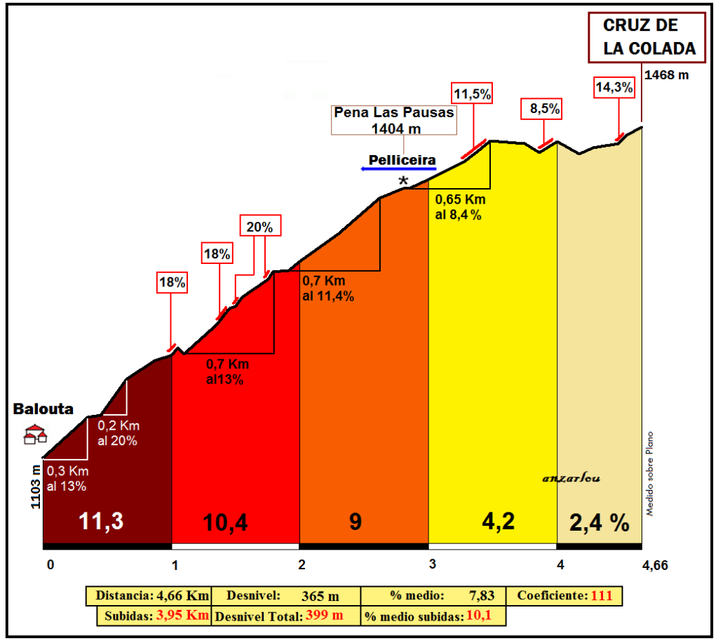
Cruz de la Colada 3,86 km at %9,2 2C (the first 3,86 km) :
COLADA_Balouta-111-466-97.png


Proposal 2 Ponferrada-Cruz de la Colada 138,4 km
https://www.la-flamme-rouge.eu/maps/viewtrack/hd/146018

Las Minas 5 km at %9,1 2C: http://www.altimetrias.net/aspbk/verPerfilusu.asp?id=1091
Lumeras 7,3 km at %5,6 2C: http://www.altimetrias.net/aspbk/verPuerto.asp?id=472
Ancares por Candin 6,05 km at %10,8 1C: http://www.altimetrias.net/aspbk/verPuerto.asp?id=311
Ancares-Cruz de Cespedosa por Pan do Zarco 7,56 km at %9,7 1C(from km 2 to Cruz de Cespedosa-km 9,5) : http://www.altimetrias.net/aspbk/verPuerto.asp?id=482
Cruz de la Colada 14,4 km at %6,27 Cat.ESP (can be 1C as well) (the last 14,4 km) :
colada_riobaloutacoro3regiones280.png
 
Re:

ice&fire said:
cabus01.jpg


Pictures in the link below. Click on the green arrow at the top right of the page.

http://www.altimetrias.net/foro/fotos/verFotospuertos.asp?id=183
Cabus is another great pick! A monstrous climb! And the road looks pretty good as well. (good enough to be climbed) And combined perfectly with Arinsal. Also nicely combined with Bonaigua, Canto, Arcalis and Ordino. Tunel de Viella-Bonaigua-Cabus-Arinsal would be an awesome stage. Finish can be on Arcalis too (but I prefer Arinsal) since the top of Cabus would be only 38 km from the finish and the false flat before the Arcalis would only be 10 kms.
 
Re:

DFA123 said:
Yeah, it's definitely useable in theory, but whether the Vuelta or the big Asturian/Leonese races would include a climb like that as a pass well before the end of the stage is pretty unlikely I think for the forseeable future. It's such a shame though - Cubilla is definitely one of the most scenic and enjoyable climbs in the whole of Spain, even if it's too easy to be really selective. But it's never going to be used as a mtf probably, because it's too far from any reasonable sized town and nearby ski resorts like Cuitu Negru are much more likely to stump up the money required.
If Lena and the general Asturian government stumps up though it has a possibility. It was strongly rumoured in 2010 to be the new MTF before the selection of Cotobello. The problem is that the toughest approach climb without doubling back on yourself is Cobertoria west. You could perhaps do Cuchu Puercu south (7,8km @ 9,6%) and loop down via Cordal back to Lena before climbing it to make it more selective, with only a short repeated section in Pola de Lena, or to toughen it up come from the west and go over either San Lorenzo or the combo of La Colledoria and Marabio, then over Cobertoria west, descend via Cuchu Puercu and Cordal, do a little loop-de-loop over Cuchu Puercu and then La Cubilla.
 
Of course, another traceur favourite is the Col de la Croix de Cœur, above Verbier and linking down to Mayens-de-Riddes/La Tzoumaz in Romandie. Probably too high for use in Romandie but perfectly doable in the Tour de Suisse, probably off the back of Champex, or even better the Col du Lein. It also allows an MTF after the descent, either super steep like Ovronnaz or a shallower one like Nendaz.

croix.jpg


There's 5km of unpaved road on the Mayens side:
CroixDeCoeurN.gif


And 2,5km of it, but much steeper, on the Verbier side:
CroixDeCoeurS.gif
 
Re: Re:

Libertine Seguros said:
DFA123 said:
Yeah, it's definitely useable in theory, but whether the Vuelta or the big Asturian/Leonese races would include a climb like that as a pass well before the end of the stage is pretty unlikely I think for the forseeable future. It's such a shame though - Cubilla is definitely one of the most scenic and enjoyable climbs in the whole of Spain, even if it's too easy to be really selective. But it's never going to be used as a mtf probably, because it's too far from any reasonable sized town and nearby ski resorts like Cuitu Negru are much more likely to stump up the money required.
If Lena and the general Asturian government stumps up though it has a possibility. It was strongly rumoured in 2010 to be the new MTF before the selection of Cotobello. The problem is that the toughest approach climb without doubling back on yourself is Cobertoria west. You could perhaps do Cuchu Puercu south (7,8km @ 9,6%) and loop down via Cordal back to Lena before climbing it to make it more selective, with only a short repeated section in Pola de Lena, or to toughen it up come from the west and go over either San Lorenzo or the combo of La Colledoria and Marabio, then over Cobertoria west, descend via Cuchu Puercu and Cordal, do a little loop-de-loop over Cuchu Puercu and then La Cubilla.
Let's hope it gets used some time soon. Cuchu Puercu would definitely be a nice one to add as well, or maybe just put Cubilla at the end of an easyish transitional stage from León into Asturias - one for the breakaway to fight out, or possibly a potential 'ambush' stage.

Unfortunately I find it hard to believe the Asturias government would stump up the money now though. They're really promoting the Somiedo Mountains as a tourist destination now (which the area around La Pola and Cubilla isn't really), so Farrapona is set to stay I think as the number one fairly gentle mtf option. And you already have Lagos, Angliru, Oviedo and Gijon which all host stage finishes every other year. And with the trend for steeper climbs you have things like Ermita de Alba, Jitu, Pajares-Cuitu Negru etc.. which are probably all going to be above Cubilla in the pecking order.

Just difficult to see where it would fit in as a finish, unless Asturias does a Galicia and bids for about 10 stages one year. If they had the balls to use it as a pass though, then that opens up loads of great new possibilites.
 
Re:

Libertine Seguros said:
Of course, another traceur favourite is the Col de la Croix de Cœur, above Verbier and linking down to Mayens-de-Riddes/La Tzoumaz in Romandie. Probably too high for use in Romandie but perfectly doable in the Tour de Suisse, probably off the back of Champex, or even better the Col du Lein. It also allows an MTF after the descent, either super steep like Ovronnaz or a shallower one like Nendaz.

croix.jpg


There's 5km of unpaved road on the Mayens side:
CroixDeCoeurN.gif


And 2,5km of it, but much steeper, on the Verbier side:
CroixDeCoeurS.gif
Croix de Coeur is another awesome one. But since there is sterrato on both sides I doubt the organizers would use it as a pass any time soon, unfortunately. :(

If the organizers want to use it; Planches W-Champex S-Lein W-Croix de Coeur S-Ovronnaz S as a MTF would be awesome. Or Crans Montana E-Anzere E-Veysonnaz E-Croix de Coeur N-Planches E with descent finish on Martigny would be awesome as well.
 
Passo della Croce Arcana is another one. It is a climb on border of Toscana-Emilia Romagna. From the Fanano side the overall stats for this climb is 15,8 km at %7,3. The first 2 km averages %5,2 albeit with a false flat descent part. The next 4 kms are %7,6. Then after a very short descent the road is climbing back to around %7 for around a km. Then there are 4 kms at %7,7. The last 4,6 kms of the climb are at %7,9. And some of the last 4,8 km of the climb is not asphalted. (Not all of them because there is an asphalt part even on the last 4,8 km)
https://www.google.com/maps/@44.1518963,10.7739913,3a,75y,318.76h,78.87t/data=!3m7!1e1!3m5!1sVDH9dqus-fKvGhuJLx-FEA!2e0!6s%2F%2Fgeo0.ggpht.com%2Fcbk%3Fpanoid%3DVDH9dqus-fKvGhuJLx-FEA%26output%3Dthumbnail%26cb_client%3Dmaps_sv.tactile.gps%26thumb%3D2%26w%3D203%26h%3D100%26yaw%3D332.30048%26pitch%3D0%26thumbfov%3D100!7i13312!8i6656
qdj6hzf1c088cwkc0cw84k0-passo_della_croce_arcana_fanano_profile.gif
 
Re: Re:

DFA123 said:
Let's hope it gets used some time soon. Cuchu Puercu would definitely be a nice one to add as well, or maybe just put Cubilla at the end of an easyish transitional stage from León into Asturias - one for the breakaway to fight out, or possibly a potential 'ambush' stage.

Unfortunately I find it hard to believe the Asturias government would stump up the money now though. They're really promoting the Somiedo Mountains as a tourist destination now (which the area around La Pola and Cubilla isn't really), so Farrapona is set to stay I think as the number one fairly gentle mtf option. And you already have Lagos, Angliru, Oviedo and Gijon which all host stage finishes every other year. And with the trend for steeper climbs you have things like Ermita de Alba, Jitu, Pajares-Cuitu Negru etc.. which are probably all going to be above Cubilla in the pecking order.

Just difficult to see where it would fit in as a finish, unless Asturias does a Galicia and bids for about 10 stages one year. If they had the balls to use it as a pass though, then that opens up loads of great new possibilites.
Cubilla does have a possibility in the Vuelta a Asturias if Acebo falls through one year though, as Lena always stumps up, although they seem to like descending from Cobertoria, or having the punchy Carabanzo climb at the end. Cuitu Negru suffers from the flat section between Pajáres and Brañillín that means that no action will happen before then, so really it has to be the first mountain stage of a group (it is well located for this as you could feasibly arrive in Asturias and just have a fairly light stage ending on it, for example through San Isidro into Asturias then over Cuchu Puercu northeast (the Cordal from Lena side) and up to it, or into Asturias through Ventana then over Cobertoria west and Cuitu Negru, before a more comprehensive multi-climb odyssey of a stage through the region the next day.

I don't see Asturias doing the same as Galicia or Andalucía and bidding for about a week's worth of stages, and that's because it is a single province that is also a direct sub-region of Spain, like Cantabria or Murcia, and doesn't have the various provinces within a Comunidad to keep happy like Catalunya, Comunidad Valenciana or Andalucía; if Galicia is going big for the Vuelta, then the four Provincias that make up the region can then compete, if there are several willing hosts, they will then pay up to host more of the race; Asturias doesn't have a huge number of large towns and cities that would provide willing hosts other than the MTFs, which is why we see Gijón, Avilés, Oviedo, Llanes and Cangas de Onis so often, and elsewise often tourist locations like the Museo Jurásico in Colunga or Covadonga. Especially in the mostly undiscovered-by-la-Vuelta west of the principality, where traceur favourites like La Marta, La Bobia, the harder sides of El Acebo, Piedratecha and Arredondas are undiscovered, mainly due to a lack of feasible hosts away from the coastal towns, with arguably only Tineo and Cangas del Narcea being sufficiently sized to justify hosting as the rugged terrain and comparatively restrictive transport links make it hard to justify a small stage host the way they could somewhere more accessible from the mining valleys in the centre of the province that make up the majority of the region's population.

Now for a favourite of mine: Kunkelspass.

This is a very narrow road north of the Lenzerheidepass that links to Bad Ragaz in the north and enabled me to create an absolutely brutal stage for a Tour de Suisse that I never got round to putting in the Race Design Thread because the rest of the stage didn't hang together well. This was stage 8, with the final race day being an MTT on Malbun in Liechtenstein (I think by now the fact that I am a fan of that climb is fairly well known). The Kunkelspass is a very lopsided climb, with the north face being fully asphalted, but very, very narrow, and the south face being very, very steep and with two stretches of sterrato.

KunkelsS.gif


The stage in question was intended to start down in the Locarno area (stage 7 would be a transitional stage with a finishing circuit of the Mendrisio Worlds course) and go over Passo San Bernardino, Mathon, Lenzerheidepass and finally Kunkelspass 24km from the line, most of which would be the two-stepped descent.

kunkels_10.jpg


Most of it is not too bad, but there are some potentially OTT sections in the sterrato. And you know... gravel + tunnels...

16Kunkelspass_orig.jpg


Here's some video of the climb from 2013.
 
There is also the Vizzaveta side that I used in my Giro but there is not a profile for it. It shares the last 3,65 km with the Cutigliano side (so it still has 1,7 km of gravel on the end) and the road before is perfectly fine on asphalt. The stats for that side is 17,1 km at %6,86.

@LS That Kunkelspass is a monster! I haven't heard of it before! And there is a gravel road inside the tunnel as well!
 
Re:

Forever The Best said:
There is also the Vizzaveta side that I used in my Giro but there is not a profile for it. It shares the last 3,65 km with the Cutigliano side (so it still has 1,7 km of gravel on the end) and the road before is perfectly fine on asphalt. The stats for that side is 17,1 km at %6,86.

@LS That Kunkelspass is a monster! I haven't heard of it before! And there is a gravel road inside the tunnel as well!
I found that one on quaeldich when I was searching for a way to make a Malbun stage less of a one-climb ascent, because it's a perfectly located one to lead into Liechtenstein (although there would be a fair few km of flat between the bottom of the descent and the base of Malbun so would perhaps be of less value, perhaps better if you just did Triesenberg and ended in Vaduz) and connects the region via a tough climb to the region with Albulapass, Julierpass, Lenzerheidepass and other better known Swiss climbs. The projected stage I mentioned above looked like this:

3GKJiLc.png


The problem for it as far as I see is that there's nothing similar that the Tour is interested in doing and at present for reasons I don't fathom, and more or less refuse to fathom, the Tour de Romandie is proving a much more popular race than the far superior Tour de Suisse, which with its June position on the calendar is now doomed to Giro contenders trying to hold form competing against second tier Tour contestants as against the Dauphiné, due to ASO safeguarding their race by mimicking the Tour route as closely as possible, and while it's not too far from the border for the Giro if somebody wants to pay up, it's unlikely. Therefore including a monster like Kunkelspass isn't going to be of benefit to Tour contenders in their tuneups unless the Tour starts putting climbs like the Iparraldean monsters we often clamour for into the route or unearths a super steep gravel climb somewhere, so it's more likely to put off prospective Tour de Suisse riders than encourage them.
 
Re: Re:

Libertine Seguros said:
Forever The Best said:
There is also the Vizzaveta side that I used in my Giro but there is not a profile for it. It shares the last 3,65 km with the Cutigliano side (so it still has 1,7 km of gravel on the end) and the road before is perfectly fine on asphalt. The stats for that side is 17,1 km at %6,86.

@LS That Kunkelspass is a monster! I haven't heard of it before! And there is a gravel road inside the tunnel as well!
I found that one on quaeldich when I was searching for a way to make a Malbun stage less of a one-climb ascent, because it's a perfectly located one to lead into Liechtenstein (although there would be a fair few km of flat between the bottom of the descent and the base of Malbun so would perhaps be of less value, perhaps better if you just did Triesenberg and ended in Vaduz) and connects the region via a tough climb to the region with Albulapass, Julierpass, Lenzerheidepass and other better known Swiss climbs. The projected stage I mentioned above looked like this:

3GKJiLc.png


The problem for it as far as I see is that there's nothing similar that the Tour is interested in doing and at present for reasons I don't fathom, and more or less refuse to fathom, the Tour de Romandie is proving a much more popular race than the far superior Tour de Suisse, which with its June position on the calendar is now doomed to Giro contenders trying to hold form competing against second tier Tour contestants as against the Dauphiné, due to ASO safeguarding their race by mimicking the Tour route as closely as possible, and while it's not too far from the border for the Giro if somebody wants to pay up, it's unlikely. Therefore including a monster like Kunkelspass isn't going to be of benefit to Tour contenders in their tuneups unless the Tour starts putting climbs like the Iparraldean monsters we often clamour for into the route or unearths a super steep gravel climb somewhere, so it's more likely to put off prospective Tour de Suisse riders than encourage them.
I unfortunately can't see your stage because Imgur is blocked on my country.
Agree with your second paragraph but also the routes of Tour de Suisse are making matters worse since they are mostly ______/ or _/\___/
 
Re: Re:

This is an interesting topic. However, while there are like 4 times more unpaved climbs than paved ones, often their quality is more MTB suited... It's a tough, but interesting journey to find something less explored, but mayb raceable by a road bike...

Libertine Seguros said:
Forever The Best said:
Trobaniello is like Finestre, the side which should be climbed is gravel and the flat sterrato part is less than 3,5 km and looks safe. I already used it on my 2nd Vuelta. Vegarada is similar too since the side that should be used is gravel, though the state of the road looks worse but I think it can be used and I already used it on my 3rd Vuelta with the finish in EE Riopinos. Other side of La Farrapona is another great pick since it can be used as a short but steep climb either after Trobaniello or after Ventana which are greatly connected with Cobertoria, San Lorenzo and Maravio. Then you can alternatively descend the side that is climbed to finish in Pola de Somiedo.

Parpaillon is unpaved on both sides so I don't think it will be used at any point in near future as a pass and it is pretty known. Also which side of Sahun is asphalted? The one from Plan or the one from Castejon de Sos or none?
I think the state of some parts of Vegarada makes it difficult, I mean it's not quite as untenable as Piedrafita (the one in Asturias, not the more famous one in León, close to the Puerto de las Gobernadas and Fonte da Cova) but still. Piedrafita is an off-shoot of the Vegarada road and it's preposterous.

On Sahún, both sides are partially asphalted, then have some sterrato and a stretch of hormigón at the summit.

PRC also like to use the north side of Rasos de Pegüera, which has some sterrato that links the Coll de Fumanyà with the ski station.

rasos-por-figols.png


This is the road, though, so it's borderline.

pista-rasos-2006-ramaca.jpg
You want to tell me, that this stack of stones is "borderline"!? I never rode a road bike, but on my makeshift bike (is that the right term?) i would probably have a hurt lower back. If it's borderline, then i guess i can be a bit more flamboyant with my choices.

For now i have two proposition, but i'm not entirely sure about them. First one is the north side of Pustevny - probably the hardest climb in Moravy/Moravia (Czech Rep.). The south side is a fine, paved road. I'm not entirely sure about the other one. It's definitely a dirt road, but the satelite images are obscured by trees and i could only find one pic of the road.

kRxYnc.jpeg


Here it looks really nice, but i doubt it's entirely like that. Here's the map and profile.
BQhW90l.jpg

SO5JtUw.png

https://www.la-flamme-rouge.eu/maps/viewtrack/hd/146822

You can use it as either MTF (there's some space for a smaller race) or a tricky, Tuscany like finish in Rožnov pod Radhoštěm. Also, i've included Vysočina Arena in Nové Město, so Libertine can... :cool:.
Bsx2YQP.png

https://www.la-flamme-rouge.eu/maps/viewtrack/hd/117760

My other find was purely accidental. I was wondering about a medium-mountain stage to Rieti consisting of Sella Leonessa and i found this road (Monte Metano), which triggered an interesting Spoleto finish. There are some small places that need some cleaning, but for most part it seems to be a fine quality sterrato. The stage below isn't really possible for a Giro, but it looks quite interesting (for a 3rd week). Just change the depart to Todi and you can have a grande finale in either Perugia or Florence.
eUOePQi.png

4lZEJf8.png

https://www.la-flamme-rouge.eu/maps/viewtrack/hd/134303

That's what i have for now. If i'll find something interesting i'll post it here.
 
Puerto de Javalambre in Aragon, south of Teruel.

fauniera said:
VUELTA A ESPANA

The final 24 km are entirely on sterrato (except for the last few hundred meters at the ski station) and include the climb of Puerto de Javalambre.

D5aYSYw.png

Khf14mM.png


Puerto de Javalambre is 10,4 km long and has a average gradient of 6,5%. The climb goes up in three steps, interrupted by false flats. The first step is 2,4 km at 8,5%, the second 2,2 km at 8,2% and includes half a kilometer at 11%. The third step is 2,2 km at 8,5%. I'm pretty sure the race will explode on these demanding sterrato slopes.


qgBijFP.png

WJEwR4H.png

OMe718q.png


We have now reached a high plateau, where we will stay for the rest of the stage. There are still 10 km to go, all on sterrato, on undulating terrain. The scenery is a completely barren landscape in the middle of nowhere.

TkBQffg.png

KAB8167.png

uIplOwn.png

RUlRDqh.png


The whole sterrato section is on Streetview, in case you can't see the imgur pictures. With 3 km to go we crack the 2.000 meter mark (just) on the highest point of the stage. The rest is downhill to the ski station of Javalambre. Here is a video of the descent, but only to the 1:16 mark, when they should have turned left to stay on our course.

YoJQtqz.jpg


There is plenty more sterrato in this area, by the way. One could build a true sterrato monster stage here, the only problem is that the ski station is the only possible location for a stage finish. Apart from that there are only tiny villages and wilderness.
 
Collado Nieva in Comunidad Valenciana.

fauniera said:
VUELTA A ESPANA

TxXyHfF.png


The final 10 km are on sterrato again and feature the climb of Collado Nieva (9,6 km at 5,7%).

W2paYXq.png


The first 3,3 km are the hardest with an average gradient of 10,2%. Lots of switchbacks, too.

gpFt1ym.jpg

Myo2cI1.png


The final 6 km are mostly false flat along the mountain ridge with a few steeper sections in between.

SGIZjJ0.png

4lnTxAU.png

m5OLBJY.png
 
How's about one that's very feasible for a race: the Planaistraße in Austria?

Weighing in at 12,2km at a fairly consistent 8,5%, this is not too dissimilar to Kronplatz. The first part is all tarmacked, the second part is packed dirt, easily wide enough and smooth enough to host racing.

The road looks like this.

The other thing with it is that Planai is a famous name in wintersport, as one of the best renowned Alpine courses around, and a regular World Cup host as part of the Schladming series of slopes. Close up of the road. As a result, traffic including shuttle buses for spectators has to use this road, so it's easily usable for the cars and bikes, and there's a more than reasonably-sized station at the top.
 
Yes, dead-end. There are a lot of dead-end roads (mountain top finishes) in that area.

Planai would have the advantage that Schladming is quite a rich town which could afford to host a finish of the Österreich Rundfahrt, for example.
 
Col Visentin

Located between Belluno and Vittorio Veneto. 17,5 km at 9%. The first 11,5 km are on asphalt, the final 6 km are on sterrato.

s3vGyoq.png

FcLHUxG.gif

WiwmkUk.png

LRJGVIx.png

lY3Wg8S.png

NOM1kW8.png

BdS0XrM.png

D3eE0Zn.png

ukcp6Hd.png


Unfortunately there is not a lot of room at the top.

9WbskxX.png

EcXCVIn.png


The road continues to Nevegal, but isn't really ridable.

VIMdrcG.png

7NZwPxG.png


Interesting road halfway to Nevegal.

mI5vHmR.png
 
Mt. Şekersu Village ( 29.4 km, %7.1 average)
Located between Çaykara/Rize and Bayburt, this is one of the toughest climbs in Turkey. And it is rideable. It is the road between Uzungöl and Bayburt, only a couple of kms away from Soğanlı Pass D-915.
The complete stats are 29.4 km at %7.1 average, but it does not tell the whole story. The last 14 km are on sterrato ( I'm not sure when sterrato starts but it starts a bit after they will exit Uzungöl. Plus, there are some parts which are a mixture of hormigon and asphalt but most of it is sterrato. ). And the last 13.9 km are %8.7 average!. And it has pitches of %18-20 at various points.
Just look at the profile:
https://www.cronoescalada.com/index.php/puertos/viewProfile/20043/6945

What can you do after the top of the climb?
After the top of the cllimb, there is a couple of kms of gravel roads till we join D-915. Here you can either take the final 2.5 km of rolling roads with sterrato to Soğanlı Pass, to end. I designed a stage like this, starting from İspir and climbing the easier side of Mount Ovit before Mt. Şekersu Village ( 31 km at %4.9, probably still a HC climb ):
https://www.cronoescalada.com/index.php/tracks/viewTour/624249/303837

However,there is also an option to go to Bayburt. In that case, after joining D-915 we still have 7.5 km of descending at sterrato. After the sterrato ends we almost have 30 kms to the finish in Bayburt. I have designed a stage from Of to Bayburt, with one big climb, Mt. Şekersu Village:
https://www.cronoescalada.com/index.php/tracks/viewTour/623891

Some photos from the climb:
climb:
https://www.google.com/maps/@40.6061935,40.3090805,3a,75y,252.99h,79.04t/data=!3m8!1e1!3m6!1sAF1QipN5jSrSJpxNSKp0ZwK-ZwjYt65X1sHc81PmSdbI!2e10!3e11!6shttps://lh5.googleusercontent.com/p/AF1QipN5jSrSJpxNSKp0ZwK-ZwjYt65X1sHc81PmSdbI=w203-h100-k-no-pi-0-ya346-ro-0-fo100!7i8704!8i4352
https://www.google.com/maps/@40.592802,40.3025995,3a,75y,320h,90t/data=!3m8!1e1!3m6!1sAF1QipOzkRSq-JaQJNGgKQf_2bL1GS68DU_UNe1zy6EQ!2e10!3e11!6shttps://lh5.googleusercontent.com/p/AF1QipOzkRSq-JaQJNGgKQf_2bL1GS68DU_UNe1zy6EQ=w203-h100-k-no-pi-0-ya207.99998-ro-0-fo100!7i8704!8i4352
https://www.google.com/maps/@40.5737806,40.2992808,3a,75y,336.87h,67.9t/data=!3m8!1e1!3m6!1sAF1QipNBQpDPM8Az97URR8a7F-yKi1x7tuQAf5qk_eH0!2e10!3e11!6shttps://lh5.googleusercontent.com/p/AF1QipNBQpDPM8Az97URR8a7F-yKi1x7tuQAf5qk_eH0=w203-h100-k-no-pi-20-ya202-ro-0-fo100!7i10240!8i5120
https://www.google.com/maps/@40.5693821,40.2966315,3a,75y,0.91h,99.95t/data=!3m8!1e1!3m6!1sAF1QipNGIwlbuc4zwD4xVv94AtRsb647Jjn9SWnH9Wr0!2e10!3e11!6shttps://lh5.googleusercontent.com/p/AF1QipNGIwlbuc4zwD4xVv94AtRsb647Jjn9SWnH9Wr0=w203-h100-k-no-pi-20-ya62.00001-ro-0-fo100!7i10240!8i5120

The intersection where Uzungöl-Bayburt road joins D-915:
https://www.google.com/maps/@40.511...5HkpHKFR6Fvag!2e0!7i13312!8i6656!9m2!1b1!2i22
More sterrato on the descent to Bayburt:
https://www.google.com/maps/@40.504276,40.2483825,3a,75y,246.87h,71.15t/data=!3m7!1e1!3m5!1s2V0-E7rj1LTy1da_71OEHQ!2e0!6s//geo1.ggpht.com/cbk?panoid=2V0-E7rj1LTy1da_71OEHQ&output=thumbnail&cb_client=maps_sv.tactile.gps&thumb=2&w=203&h=100&yaw=119.13198&pitch=0&thumbfov=100!7i13312!8i6656
 
Last edited: