Race Design Challenge II

Page 12 - Get up to date with the latest news, scores & standings from the Cycling News Community.
Via Roma Stage 15 Scythopolis (Nysa) --> Har Senaim (Neve Ativ) 177 km
Why are ye fearful, O ye of little faith? - Jesus
RQqDLW1.png

OrKTORR.png


Stage 15, and the first big mountain finish of the race. Although the stage was always going to come down to final climb, given the route tomorrow, the 3,200m of vertical ascent means the the opportunity will be there if anyone is willing to risk going too deep today, and the pure climbers will definitely be feeling the pressure to gain time, after the two long time trials.

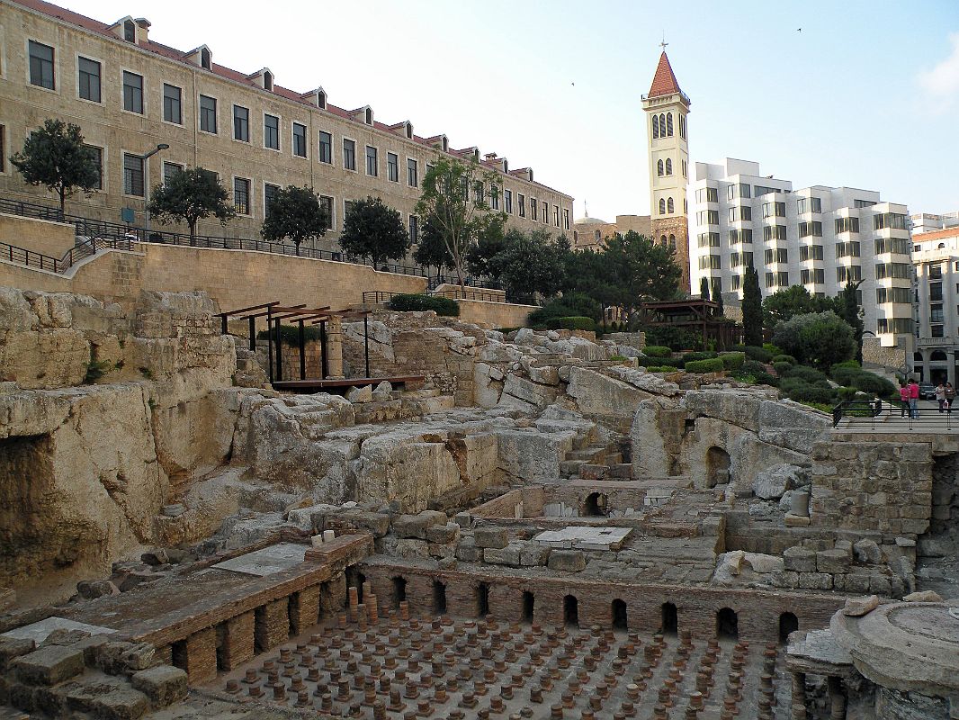
The stage starts gently enough, in the town of Scythopolis. The town was initially burnt to the ground, towards the end of Greek occupation, but was rebuilt under the order of Pompey after he conquered the area. Scythopolis grew in prosperity, and became the capital of the Decapolis, a confederation of 10 Roman occupied city states, which were given additional autonomy in the Roman empire, enabling the city to become particularly wealthy. This led to the some excessive public spending, including the below bridge, which is unnecessarily larger that the stream it crosses.
Scytho09.jpg


After leaving Scythopolis, the stage goes North West for 30 odd kilometres, before it climbs the first hill of the day, 5.5% for 6.6 kilometres, this cat 2 climb peaks in the town of Nazareth, a relatively small settlement in Roman times, obviously most famous as the place Jesus grew up. There is another 20 km of flat before the next uncategorised climb, peaking next to the town of Yodfat, location of a major siege in the First Jewish-Roman War.
1024px-Yodfat_071108_001.jpg


A small gully provides another minor uncategorised climb, before the day second category two climb looms into view with 90km left to ride. This climb is 8.2km at 6.2%, with the final 5 kilometres having a gradient of 7.7%. a third cat 2 climb soon follows this time a more stepped affair, although the final gradient still reaches 5.5% over the 6.8km of climbing.

The route then rolls along the top of the plateau, before descending to the valley floor with 32 km left to ride. The riders the cross the valley as they approach mount Hermon, and the days final climb. The road starts to rise well in advance, and having already gained 200m in altitude, the stage final comes to the days sprint point, with just 10km to go, potentially given the GC riders a chance to steal a few seconds.

The sprint point is at the former town of Caesarea Paneas, although it's name changed a few times. Initially named Paneas, it was renamed Caesarea by Phillip II, and then know as either Caesarea Paneas or Caesarea Phillipi. It was then renamed Neronias Irenopolis, in honour of Emperor Nero, however after he committed suicide, the name reverted back to Caesarea.
1024px-Caesarea-phil-palast-des-agrippa.JPG


Mount Hermon was one of the most holy sites in the middle east, with a multitude of temples on its slopes. The mountain peaks at a height of 2800 metres, and the temple on the summit is famous as being the highest in the ancient world. Unfortunately, there is no road to the summit, ruling that out as a stage finish. Also unfortunately, most of the higher temples on the Lebanese or Syrian side, and there is a distinct lack of roads across their borders with Israel. Hence the finish of today's stage at an altitude of 962 metres, after a category 1 climb, averaging 6.6% for 9.2 km.

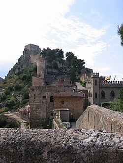
The stage finish is in the modern town of Neve Ativ, just below the temple of Har Senaim. Har Seniam was a Roman temple, built next to an old Greek temple. The altar contained a relief of Helios, and it contained an inscription praying for the salvation of Emperor Hadrian. Below is a blueprint of the temple.
img-1-small700.jpg
 
Stage 15! Whooo-hooo we caught up finally!

JUDGE 1:

Gigs_98 T: 2 C: 3
At least this one ought to be something of a leg breaker with so much up and down.

Brullnux T: 3 C: 3
A long and tough ITT, nice strategic locations but solid rather than spectacular.

Rghysens T: 4 C: 4
Finding a way to even get Ventoux in there which means we should get action simply due to the sheer difficulty of the climb, plus Nîmes' Roman history is a winning choice.

mb2612 T: 4 C: 4
Going down to the sea of Galilee between Nazareth and the climb after Karmiel might have got you a 5. Good work with Mount Hermon even if the race theme has limited you slightly.


JUDGE 2:

Gigs_98 T: 3 C: 2
This flat stage is more interesting than most

Brullnux T: 4 C: 4
Good TT to and a nice place to hold one

Rghysens T: 4 C: 3
About as good as you can get in that part of the Roman Empire

mb2612 T: 3 C: 4
Nice MTF, and a pretty prolific place to ride around too


JUDGE 3:

Gigs_98 T: 3 C: 2
Not only is this area uninspiring from a cycling viewpoint, but it is also pretty dull from a Roman history point of view. I am probably a little too generous in giving you 3 technical points, but I like the way it is not completely plain sailing for the fast men.

Brullnux T: 4 C: 3
Nice long ITT. Cartagena is a nice choice for it too. In the spirit of my marking today, I am being a little generous to you too, this time on the cultural side.

Rghysens T: 4 C: 5
Too many contestants have been in France and avoided the Pont du Gard. This should be a must have for the race. It being within striking distance of Ventoux made this stage a penalty kick. But I give kudos to you for burying it with aplomb. Nice start and finish locations too. Chapeau!

mb2612 T: 3 C: 4
I like this stage, but I can only give 4 techincal points to two stages. Nothing deserves a 5 today, so you get bumped down to 3. But what Judge 3 taketh with one hand, he giveth with the other. Will give you 4 cultural points, as you have done a decent job of showcasing the area.


JUDGE 4:

Gigs_98 T: 3 C: 3
The stage is better than it looks, the sequence of little climbs could make it interesting but the last 25 km are a bit dull.

Brullnux T: 5 C: 3
I gave 5 to other long ITTs, and your route desperately needed one.

Rghysens T: 4 C: 4
Very nice. You're probably the first one to show a "classic" climb in your route, aren't you?

mb2612 T: 3 C: 4
Not a fan of pure MTFs. However, you did a nice job with showing the region heritage, as you often do.


CLASSIFICATION FOR STAGE 15

Rghysens: 32
Brullnux: 29
mb2612: 29
Gigs_98: 21


CLASSIFICATION AFTER STAGE 15:

rghysens: 614
mb2612: 563
Gigs_98: 540
Brullnux: 540
 
Stage 16: Arelate – Massalia: 203.5km, hilly

Today’s stage runs between two cities whose history, and certainly in the Roman period (and early middle ages) is tightly connected.
2e3tq83.jpg


Arelate was controlled by the Celts and used as an important port by the Phoencians, being closer to the sea than it is now.
The Romans took the town in 123 BC and expanded it into an important city, with a canal link to the Mediterranean Sea. However, it struggled to escape the shadow of Massalia further along the coast.
Its chance came when it sided with Julius Caesar against Pompey, providing military support. Massalia backed Pompey. When Caesar emerged victorious, Massalia was stripped of its possessions, which were transferred to Arelate as a reward. The town was formally established as a colony for veterans of the Roman legion Legio VI Ferrata, which had its base there. Its full title as a colony was Colonia Iulia Paterna Arelatensium Sextanorum.
Arelate was a city of considerable importance in the province of Gallia Narbonensis. It possessed a number of monuments, including an amphitheatre, triumphal arch, Roman circus, theatre, and a full circuit of walls, with a necropolis just outside the walls.
In 395, Arelate became the seat of the Praetorian Prefecture of the Gauls, governing the western part of the Western Empire: Gaul proper plus Hispania and Armorica. At that time, the city was perhaps home to 75,000 - 100,000 people.
It became a favorite city of Emperor Constantine I, who built baths there, substantial remains of which are still standing. His son, Constantine II, was born in Arles. Usurper Constantine III declared himself emperor in the West (407–411) and made Arles his capital in 408.
640px-Ar%C3%A8nes_d%27Arles_1.jpg


640px-Thermes_de_Constantin16-9.jpg


The official start at the northeastern edge of the city is soon followed by the first Roman landmark sprint, after just 7km. here the Romans built a watermill complex on two parallel aqueducts, sometimes referred to as "the greatest known concentration of mechanical power in the ancient world".
The mill consisted of 16 waterwheels in two separate descending rows built into a steep hillside. Their capacity has been estimated at 4.5 tons of flour per day, enough to supply bread for as many as 10,000 of perhaps 30-40,000 inhabitants of Arelate at that time. Now, it is too overgrown with shrubbery to make a real impression

A bit further on the road, the first climb of the day may see a breakaway get clear. Its summit is the location of the second Roman landmark sprint in this stage. Although the Gallo-Roman oppidum of Glanum lies halfway the descent, having a sprint in a descent may be a bit dangerous.
kc022t.jpg


Glanum was built around a sacred spring, and is best known for its mausoleum and having the oldest triumphal arc in France
373px-Glanum-mausolee.jpg


640px-Glanum-triomphal_arch-arc_de_triomphe.jpg


After Glanum, the course follows the former Via Domitia -the Roman road that linked Italy with Spain through the Alps and southern Gaul- to Cabellio, present-day Cavaillon. This was an important city at the Via Domitia, and a few remnants attest of Roman occupation. So, a Roman landmark sprint is at its place.
640px-Arc_romain_de_Cavaillon_02.JPG


While leaving Cabellio, the course goes south, heading for the former Via Aurelia and meanwhile passing the 4th Roman landmark sprint today: the Roman temple dedicated to Diana in the hamlet of Château-Bas. Here a chapel has been attached to the temple, rather than superseding it.

A few kilometres before Aquae Sextiae, current Aix-en-Provence, the course joins the former via Aurelia. Aquae Sextiae itself was the first Roman colony in Gaul, and near the city the Cimbres and Teutons were decisively defeated by the Romans under Caius Marius in 102BC.
The scanty remains of the theatre and some other buildings justify the 5th Roman landmark sprint in this stage.

Past Aquae Sextiae, the terrain becomes more hilly, so less suited to develop cities, and there will be no more Roman landmark sprints, as they will be changed for (albeit not too difficult) climbs.
The most difficult of the day will be the Route des Crêtes from La Ciotat, 4km at 7.7%, but with a very steep descent, followed by the long uphill drag to the Col de la Gineste. Its descent brings us to the centre of Massalia, where the Côte de Périer awaits the peloton. This final difficulty of the day crests 4km from the finish, situated near the old port.
The few remains of ancient Massilia are to be seen in the jardin des vestiges.
640px-Marseille_-_Le_jardin_des_vestiges.JPG


Climbs:
Côte de Mas-de-la-Dame: km21; 2.4km @ 5%; 4th cat
Côte de Fuveau: km125; 2.4km@ 4.6%; 4th cat
Route des Crêtes: km170; 4km @ 7.7%; 3rd cat
jzcy02.gif

(climb is from right to left, I know it would be "better" to climb both the Col de la Gineste and Route des Crêtes from their most difficult side,but then they would be very difficult to link to a nearby Roman city)
Col de la Gineste: km186.5; 7.4km @ 3.1%; 4th cat
Côte de Perier: km199.5; 1.8km @ 5.5%; 4th cat

Roman landmark sprint:
Km7: Aquaduct
Km21: Glanum
Km45.5: Cabellio
Km74: Roman Temple of Chateau-Bas
Km110: Aquae Sextiae

Total distance raced: 3449km
 
I have extremely little time, sorry

Iter per Imperium Romanum Stage 16: Lucentum-Sucro 240km
u28VZMM.png

2c8gaAs.jpg


The only uphill finish of the whole Tour comes after a long a difficult day through Eastern Spain.

The day begins in Lucentum, which along with Cartago Nova, Valentia and Barcino were the most important cities on the Spanish coast. The riders will quickly take on Xorret del Cati to soften up the legs. Rolling terrain follows before the finale: two pretty easy hills before a technical uphill finish at the (initially) Roman castle of Sucro, now Xativa.

250px-Castell_Xativa.jpg
 
Via Roma Stage 16 Berytus (Beirut) --> Husn Sfiri 291km
Stop quoting laws, we carry weapons! - Pompey
QQW8zqG.png

4zQctvg.png


Almost certainly the queen stage of Via Roma Stage 16 gives every opportunity to the climbers to make back what they lost in the two time trials. At over 290 kilometres in length, and with over 8,300 vertical metres gained this stage should see the race properly torn to shreds.

The stage starts in Berytus, a Roman town conquered by Pompey in 64 BC. it was made a Roman colony, and became the most Romanised city in the Middle East. Berytus was probably most famous for its law school, which was so highly recognised that Berytus became known as the mother of laws. As Roman law developed, the recording of precedent became more important, and Berytus was the repository for all the edicts in the empire, making it the centre of legal learning. Eventually Constantinople started to challenge Berytus and then a tsunami in 551 BC destroyed the law school, and it was never rebuilt.
Beirut%2024%20Roman%20Baths%20With%20Council%20for%20Development%20and%20Reconstruction%20Building%20And%20Saint%20Louis%20Capuchin%20Church.jpg


The stage leaves Berytus and immediately starts climbing, with an uncategorised straight off the bat, 8.2km at 8.3% up to the Roman summer town of Balmarcodes (Beit Meri). The route follows he ridge for 8km before climbing to a higher ridge, this time for at 6.5% for 6.8 km. Here the category 1 climb is marked, and in the first 25 kilometres the riders have gone from virtually sea level to an altitude of 1233 metres.
pi-liban-beyrouth-beit-mery-25-06-78.jpg


After 10 kilometres of descending the climbing starts again, this time the days first HC climb. The climb itself is 14.6km at an average gradient of 6.7%, and while that is, arguably not more difficult than the combination of the previous two climbs, I think the combination of all three makes this worth HC status. After the top of the climb the rider starts descending, and 2km later pass the temple at Faqra. It is believed that these temples were used as part of a series of fire signals from the coast to Heliopolis over the mountains.
tumblr_myyr5lCpun1rgfuxjo2_r1_1280.jpg


This is followed by the days most quite portion of racing. A 15km meandering descent leads into an uncatagorised 7km climb, averaging 4.4%. This is followed by the route passing another temple complex, at Afeka (Afqa). A temple complex like Delphi, and dedicated variously to Aphrodite, Venus and Ashtoreth, the temples were famous for their ritualised orgies, until these were banned by Emperor Constantine. Another 12km climb follows, this one starts sharply, before smoothing off, with an average gradient of just over 5%, and a category 2 rating.
afqa-temple-5.jpg


The peak of this climb allows the riders to look out onto the Bekaa Valley below, where they descend before passing through the days sprint point near the ancient Temple to Apollo after 116km. Then follows the longest period of flat the peloton will face today, 20km before they reach the start of the climb up Mount Lebanon. Starting at an altitude of 100 metres, the climb starts with a stepped section of 8.8 kilometres, at a gradient of 6.6%. This is followed by three and a half km of flat before the climb properly gets going. And once it gets going it never stops, for 15.2km it averages a gradient of 6.5%, peaking at an altitude of 2,578 metres, and giving the total HC climb an average gradient of 5.9% for fully 26.8 kilometres.
Makmal%20Lebanese%20Mountain.jpg


Over the top of the climb, what's left of the bunch will descend for the next 50km, including 15 km of flat in the middle, back down to the reasonable altitude of 600m. Before the climbing starts again with 80km left to ride. While Mount Lebanon would have given a rider with teammates in the break a chance to build a gap, this is probably the earliest a GC rider will attack solo. First up comes a short 4.4km climb, at a gradient of 7.4%. This is followed immediately, by a first category climb, 6.5% for 10.2km, before the stage again descends, down to just 100m above sea level.

hVwM1TW.png

Off the bottom of this climb, the riders start climbing again, with 3 km of gradual rise, before the 11.8km category 1 climb starts. It's average gradient is 7.4%, however the third kilometre of the climb has an average gradient of 15%, which is all but guaranteed to split any final selection of riders, with still 30km to ride.

Over the top of the penultimate climb, and 11km of downhill follow, before another short, sharp rise, of 150 metres over 2km followed by another kilometre of descending to the base of the final climb. The final climb itself is another brutal cat 1 climb, steeper than anything else the riders have faced so far, it averages 10.8% for its 5.9km, with the final 3km at 12.8%. It is another first category climb, obviously with double points. The sheer number of points available today, will make it an absolutely key stage in the race for the mountains jersey.

The stage finishes at the Sfirehan Roman Temple. The temple complex at Sfireh was one of the largest in Lebanon, however it has mostly been built over by the current town. The temple was built during the reign of Septimius Severus, whom the town is named after. The remaining temple is very distinctive, as the main wall, with the entrance still intact remains standing.
44bfb120ac7eaa232d859fd2bbe5ae88.jpg
 
Ooops. I was already complaining that I didn't get any scores from the judges :D


Gigs's stage 16:
CONSTANTINOPOLIS-ROMA stage 16: Elusa - Torre de Urkulu
evcYAWK.png

0ErxbkY.png


Stage 16 starts in Elusa (Eauze):
la-domus-de-cieutat-elusa.jpg

photo.jpg


For the technical points I definitely could have started this stage a bit later too, but I wanted to use Elusa as the start, due to it's impressive Roman excavations. Still one could now think that this is another pan flat stage for sprinters if you only look at the first 150 kilometers, but then the stage changes drastically and the riders face a few of the hardest climbs in the western part of the french pyrenees.
AhusquyNW.gif
BurdincurutchetaW.gif


After the top of the 2nd climb there is some up and down, the street is never really flat though. To encourage attacks before the descent I put the Golden Mile there. Who knows, some riders might already need all the time they can get. Then however the highlight of the stage starts, the climb to the Torre de Urkulu.
ArnosteguyE.gif


To be fair the climb isn't harder than the other ones. What makes it special are the Ruins of a Roman tower at the top , which give me the possibility to make a really tough mountain top finish in this race. Generally I'm not the biggest fan of mtf's, but I think a gt completely without them would be lame too.
41_urkulu_03.jpg


This tower was built in the first century AD, after the conquest of Aquitaine, to mark the Southern border of the empire.
 
Okay we got this.

Don't forget, today is stage day.

JUDGE 1:

Gigs_98 T: 4 C: 3
Pretty nice stage. Very cool to get a decent MTF out AND use a criminally underused part of the Pyrenees.

Brullnux T: 3 C: 2
Apart from a nice finish not very exciting

Rghysens T: 4 C: 3
Really good last 50km

mb2612 T: 5 C: 4
Just Zomegnanesque.


JUDGE 2:

Gigs_98 T: 4 C: 2
This is a nice stage. Good hard climbing, well linked. I agree the MTF finishes will be relished a lot more in such a grand tour. Not a very exciting stage culturally.

Brullnux T: 3 C: 2
This stage would be frustrating in the Vuelta, but given the paucity of uphill finishes in the race, it would be interesting enough. Not a very exciting part of the empire, however.

Rghysens T: 4 C: 3
Nice hilly stage in an interesting area for Roman culture. Stages finishing in Marseille are rarely this good.

mb2612 T: 5 C: 4
This stage is a beast. Really nice climbs – carnage guaranteed after yesterday. Beirut is an interesting spot in terms of Roman history, and you have done a good job of showcasing the area. I was nearly not going to give you a 5 technically as it is so unrealistic, but it is no more unrealistic than the premise of this project overall.


JUDGE 3:

Gigs_98 T: 4 C: 3
I didn't expect anybody to go to the Basque country. Nice finishing spot, though there isn't a great deal of room - at all - up there. Also descending the Errozate climb looks absolutely terrifying. If the descents can be made safe enough the connectivity of climbs at the end is great, however.

Brullnux T: 3 C: 3
Could have done with the run-in being a bit more challenging, as it is it would seemingly be just about the seconds gained on the final climb. Campello/Portillol a possibility?

Rghysens T: 4 C: 4
Another very nice stage, the last 80km or so are tough enough that the run-in should be hard to control directly off the back of a Mont Ventoux stage.

mb2612 T: 5 C: 4
To tell you the truth this one is probably overkill, but at the same time, this is a 4-week GT over a colossal area, with 500km stages allowed. We're in the business of excess, and this is a more than worthy queen stage within those parameters. More than one stage like this could cost you, however.


JUDGE 4:

Gigs_98 T: 4 C: 3
Whoa, a proper MTF! Not a great fan of them either, but this one is quite good.

Brullnux T: 3 C: 3
The finish is a bit disappointing, with the last climbs being quite easy, but it's still a decent stage.

Rghysens T: 3 C: 5
I really like how much Roman heritage you crammed into this stage. Too bad the technical side isn't as awesome.

mb2612 T: 5 C: 4
Worthy to be called a queen stage.


CLASSIFICATION FOR STAGE 16

mb2612: 36
Rghysens: 30
Gigs_98: 27
Brullnux: 22


CLASSIFICATION AFTER STAGE 16:

rghysens: 644
mb2612: 599
Gigs_98: 567
Brullnux: 562
 
Now, before I forget, here's Gigs's stage 17.

CONSTANTINOPOLIS-ROMA stage 17: Iacca - Lugdunum Convenarum (228 km)
TksxuBx.png

3AkEICi.png


After the start in Iacca (Jaca), where the battles between Pompeius and Sertorius took place, the first climb is the Alto Petralba, the first climb of the Formigal stage in this years vuelta.
After this relatively easy warm up climb the stage gets serious with 4 1st category climbs in a row, and you will definitely be familiar with the last 3 of those. The Col d' Azet, the Col de Peyresurde and the Port de Bales. Before the last two ones there is an intermediate sprint in Aquae Onesiorum (Bagneres de Luchon)
AzetW.gif
PeyresourdeW.gif
BalesS.gif


After the descent from the Port de Bales and the golden mile there is another short climb, the Mont de Galie. This ascent could be crucial for the stage win and after such a hard stage it might even cause time gaps between gc contenders if these aren't already made. The finish is in Lugdunum Convenarum:
St-Bertrand-dC-Theater-1.jpg

22875102277_610d2a37ca_b.jpg
 
Stage 17: Forum Julii – Tropaeum Alpium: 183.5km, medium mountains

A transfer brings the peloton to Fréjus, Roman Forum Julii. This will be the start of the third consecutive difficult stage.
zoe4r4.jpg


Julius Caesar wanted to supplant Massalia and he founded the city known as 'Forum Julii', meaning 'market of Julius, on a crossroads formed by the Via Julia Augusta and a sidebranch of the Via Domitia.
It was at Forum Julii that Octavius repatriated the galleys taken from Mark Antony at the Battle of Actium in 31 BC.
Augustus made the city capital of the new province of Narbonensis in 22 BC which spurred its rapid development. It went on to become one of the most important ports in the Mediterranean; its port was the only naval base for the Roman fleet of Gaul and only the second port after Ostia until at least the time of Nero.
Later under Tiberius all the major monuments and amenities visible today were built; the amphitheatre, the aqueduct, the lighthouse, the baths and the theatre. Frejus had impressive wallsof 3.7 km length that protected an area of 35 hectares.
In 40AD Gnaeus Julius Agricola, who later completed the conquest of Britain, was born in Forum Julii. Stepfather of the historian Tacitus, his biography is considered one of the masterpieces of Latin literature and briefly mentions that Forum Julii was an "ancient and illustrious colony". The city was also cited several times in the writings of Strabo and Pliny the Elder.
In early 69AD the Battle of Forum Julii was fought between the armies of the rival emperors Otho and Vitellius.

640px-Frejus-aqueduc-arches.jpg


640px-Frejus-amphitheatre-03.jpg


The course follows the inland route to Cannes, meanwhile climbing the Mont Vinaigre, and then the coastal way to Antipolis, with a Roman landmark sprint in the vicinity of the Aqueduct, former city walls and theatre.
Antibes_aquaduct.jpg


The course will keep on following the coastline until Saint-Laurent-du-Var, where it will follow the river Var upstream until km75. The a right hand turn signals the start of an relentless sequence of climbs, none of them really difficult, but together they can cause some damage.
Finish is near the Tropaeum Alpium, a monument built on order of Augustus to commemorate his final victory over the 45 ancient tribes that inhabited the Alps after a military campaign from 16BC to 7BC.
When built the base measured 35 meters in length, the first platform 12 meters in height, and the rotunda of 24 columns with its statue of an enthroned Augustus is 49 metres high.
640px-La_Turbie_BW_1.JPG


Climbs:
Mont Vinaigre: km10; 5.6km @ 4.3%; 3rd cat
Collet du Lingador: km78; 4km @ 7.1%; 3rd cat
Côte du Fournas: km94; 5.2km@ 4.4%; 3rd cat
Col de la Mengarde: km108.5; 7km @ 5.6%; 3rd cat
Col de Braus: km123; 10.1km @ 6.4%; 1st cat
Col de Castillon: km140; 6.7km @ 5.3%;3rd cat
Col de la Madone: km171.5; 14.5km @ 6.3%; 1st cat


Roman landmark sprint:
Antipolis: km45

Total distance raced: 3632.5km
 
Once again, I have very little time :(

Iter per Imperium Romanum stage 17: Valenti-Dertosa 296km

15NuyWN.png

g3BWfUs.jpg


The race across Iberia continues, with a transitional stage across the Valencian community. The stage starts in Valentia, which I imagine all the judges know some of the Roman history of the city. It is only rolling for most of it, before a difficult ramp at the end that does max out at over 10%. It finishes in Dertosa, now Tortosa. The theme of visiting places where the Carthigininas fought the Romans in Spain continues, as this was where the Battle of Dertosa took place. More info here: https://en.wikipedia.org/wiki/Battle_of_Dertosa
 
Via Roma Stage 17 Apamea (Afamiyah) --> Antioch (Antakya) 170km
It is better to keep silence and be something than to talk and be nothing - Ignatius of Antioch
6zMSgyu.png

9L2ALb6.png


After the queen stage yesterday, today the peloton face a shorter rolling stage. And with the third rest day tomorrow, this stage definitely gives riders the opportunity to stage an ambush by putting some teammates up the road, then attacking across to them on the first brutal climb.

First however, the stage starts in the town of Apamea. A major military base in Roman Syria, Apamea was home to one of the biggest theatres remaining from the Roman world, seating up to 20,000 people. the town itself had a census in 6 AD, which recorded 117,000 men living there. Unfortunately, it's not clear whether men, meant adult males, or humans, so the population was either ~125,000 or ~500,000, rather a large range. Apamea is most famous however, for it's grand colonnade, which was built in the 2nd century AD, after a previous colonnade had been destroyed, and was 2km in length.
1024px-Apamea_02.jpg


After the first 25km of pan flat terrain, the road starts to steepen, and stays steep for the next 9 kilometres. The overall gradient is 12%, and the second kilometre of the climb averages 18%. Obviously the climb is categorised HC, and it gives the perfect opportunity for the race to be torn apart by a strong team.
36054992.jpg


Over the top and there is no long descent to enable the riders to recover, as the road rolls up and down on a plateau for the next 30 km, with the variable terrain making it hard to create an organised chase. The road then starts to descend, although again there are a couple of sharp rises on the way to the valley floor after 90km of racing. Midway through the descent after 70km, the daily sprint will take place, at the town of Lysias (Bourzey), a stronghold conquered by Pompey in 63 BC, after which he killed its tyrant, Silas.

After 90km the road starts climbing again, with the next 9km averaging almost 5%, including various flat sections, after a small downhill the stage hits it's second categorised climb, category 2, 7.5% for 4 kilometres. There are now 70km to go, with no more categorised climbs, however there is still almost 1,000 metres of ascending yet to tackle.

The stage winds north, across the border into Turkey, still undulating, until the final notable climb which starts with 28km to go. Short at just 2km, it averages 10.6%, and will give the best chance for a rider to go solo out of a breakway. after that climb, the road starts to descend into the finish town of Antioch.
ancient-antioch-from-above-pre-350ad-by-kayhankaplan-deviantart-com.jpg


Antioch was the third biggest city in the Roman empire, after Rome and Alexandria, and the capital of the Roman province of Syria. Antioch was a very cosmopolitan city, with people of various heritage living together, and it was also vital in the early stage of Christianity. It was here that term Christian was first coined, and also Antioch almost caused a schism in the early church between those who believed that to be Christian you had to first follow Jewish law, and those who were happy to let the Gentiles join the church.
Antioc23.jpg


The other thing Antioch was famous for was pleasure. It's suburb, Daphne was known across the empire for it's incredibly scenic location, and the pleasures that could be partaken there, with the phrase "Daphnic morals" becoming an idiom. Today, not much of Roman Antioch remains, beyond some remnants of the walls on the hills above the city.
antiochWalls.jpg
 
Re:

Brullnux said:
Well my computer is dead for some reason and I don't know how long it will take me to fix it. Almost certainly not today, I'll be honest. But we'll see
**** :(

Well I'm still waiting for a set of votes... so... :eek:

But really, I would like to finish this within October, because in November I'll be on business trip/holiday, so there's not much more time for delays anymore
 
Ok, then maybe it's time to plan ahead a little further, so it's clear when it's stage day and when it's judgment day (pun intended). Votes for a stage don't come out until all votes are in, but maybe they shouldn't have to come out before posting the next stage. I wouldn't mind it if people posted 2 stages in a day, or judges put in 2 votes in a day should they miss a deadline. Maybe that should help keep things on track.

That said, I think there's only 11 stages to go, along with 2 weekly votes, so normally we should comfortably manage this in this month
 
Re:

Brullnux said:
Problem with 2 stages on the same day is that the votes for one stage will be affected by the next stage and how it flows. Ofc, that may not be an issue, but it will change how it works
I don't think that issue is that big, and you get a little of that anyway because judges do remember the previous stages, though I try not to think of that.
 
Yeah you're right.

Anyway: I have a feeling the problem may be the hard drive is f*cked, which means in 48 hours max the dell guy (or gal) will come and replace it. I am not a hundred percent sure yet, so it could still be a software problem which would take an unspecified amount of time to fix, depending on the issue. Hopefully it's hardware, and if it is then it should be fixed by Tuesday, maximum Wednesday. The computer is still trying to work out what's wrong though. I'll update when I know.
 
Stage 18: Cenemelum – Pollentia: 224.5km, flat

30jnyw2.jpg


Nice was founded as Nikaia in the 4th century BC by the greeks, who wanted to oppose the trade network of the Phoenicians in the western Mediterranean. When the Romans came to control the area, they used the existing city as settlement. In the 1st century AD, however, they created a new town on a hill a few kilometres from the coast: Cenemelum. Cenemelum later became the capital of the roman province Alpes Maritimae. This seems impressive, but then, Alpes Maritimae was the smallest province of the whole empire, and Cenemelum wasn’t a big city either. Nevertheless, it was accordingly furnished with the proper buildings like an amphitheatre and Roman baths.
640px-Ar%C3%A8nes_romaines_de_Cimiez.jpg


640px-Decumanus_Cemenelum.JPG


From the 4th century AD Nikaia started to eclipse Cenemelum and nowadays Cimiez is just a neighbourhood in Nice.

Immediately after the start the course tackles the first climb, but descents back to the coast. From that point the ancient Via Iulia Augusta (the current Via Aurelia) is more or less followed for 85km. Meanwhile there are two Roman landmark sprints: in the centre of Album Intimilium (Ventimiglia) and near the Roman villa Matutia in San Remo, and a couple of small but well-known climbs like the Capo Berta, Capo Mele and Capo Cerva (but in the opposite direction of MSR).
Teatro_di_Ventimiglia_22.jpg


640px-Villa_romana_della_foce_abc2.jpg


In Album Ingaunum (Albenga), which hosts an amphitheatre, a necropolis, Roman baths and a late Roman baptistery, the 4th Roman landmark sprint is contested. There is also a remaining stretch of the Via Iulia Augusta, sidelined with some Roman tombs.

640px-Site_arch%C3%A9ologique%2C_Albenga%2C_Ligurie%2C_Italie.JPG


When leaving Albenga, the course climbs the very long but gradual Colle San Bernardo. Its actual descent is followed by a long downhill false flat, only interrupted by the climb to Rocca Ciglie. With 20km to go, the last Roman landmark sprint is on today’s menu, this time in Augusta Bagiennorum.
640px-Augusta_Bagiennorum.jpg


Considerable remains of public buildings, constructed in concrete faced with small stones with bands of brick at intervals, an amphitheatre with a major axis of 120 m and a minor axis of 90 m, a theatre with a stage 40 m in length, and near it the foundations of what was probably a basilica, an aqueduct, baths, have been discovered by recent excavations, and also one of the city gates, flanked by two towers.

The rest of the day keeps on going very slightly downhill, with the finish in Roman Pollentia.
Its position on the road from Augusta Taurinorum (Turin) to the coast at Vada Sabatia (Vado Ligure), at the point of divergence of a road to Hasta (Asti) gave it military importance. Decimus Brutus managed to occupy it an hour before Mark Antony in 43 BC during the civil war after the assassination of Julius Caesar.
On April 6, 402, the famous general Stilicho fought the Battle of Pollentia with Alaric I, king of the Goths. Though undecided, it led the Goths to evacuate Italy for some years (but they would come back to siege and sack Rome).


Climbs:
Montée de Cime de la Forna:km12; 11.8km @ 4%; 3rd cat
Capo Berta: km 82; 2.5km @ 4.2%; 4th cat
Colle San Bernardo: km138; 18km @ 4.6%; 2nd cat
Rocca Ciglie: km183; 5km @ 4.7%;3rd cat

Roman Landmark sprint:
Album Intimilium: km37
Villa Matutia: km52
Album Ingaunum: km107
Augusta bagiennorum: km204

Total distance raced: 3857km