
Race Design Thread
Page 170 - Get up to date with the latest news, scores & standings from the Cycling News Community.
You are using an out of date browser. It may not display this or other websites correctly.
You should upgrade or use an alternative browser.
You should upgrade or use an alternative browser.
- Feb 20, 2010
- 33,127
- 15,529
- 28,180
I like Stockholm, very scenic city. And with the climbs being so short they could make for a very good rouleur Worlds for Classics men - think that they might need to remove some of the bollards on Bastugatan on that middle section in the third photo in order to make it wide enough though.
I am going to get round to week 2 of the DeutschlandTour before long and then move on to a couple of slightly different races; the Giro challenge and some time away from home has rather got in the way...
The problem is that the latest Google Maps update has infected all sites that use it as a basis, including the previously excellent Classy GMap, which was basically a rebuild of the old Google Maps that people actually liked, rather than the new, crapified version. I went on a long and sweary rant about the awfulness of Google re their mapping software on the Race Design Challenge thread.
I am going to get round to week 2 of the DeutschlandTour before long and then move on to a couple of slightly different races; the Giro challenge and some time away from home has rather got in the way...
That's not Cronoescalada's fault though, that problem has only come up in the last few days when googlemaps changed their layout from the time-honoured "sliding scale zoom and pegman in the top left corner" to "click-button zoom and pegman in the bottom right even though to exit streetview you need the top left" because Google are total idiots who are doing their utmost to ruin every single thing about maps. Hopefully the Cronoescalada team, once they realise what a pain to their engine this latest modification by google is, will amend their program to work around it, maybe making it possible to toggle profile on and off/hide profile to enable us to change zoom or use streetview, or move/reduce the width of the profile so those buttons are still accessible.BigMac said:Worse even, in Cronoescalada, once you click to show profile, just to track your progress, streetview becomes useless as you can't reach the yellow pawn thingy.
The problem is that the latest Google Maps update has infected all sites that use it as a basis, including the previously excellent Classy GMap, which was basically a rebuild of the old Google Maps that people actually liked, rather than the new, crapified version. I went on a long and sweary rant about the awfulness of Google re their mapping software on the Race Design Challenge thread.
- Aug 21, 2015
- 380
- 0
- 9,280
Re:
It happens to me every once in a while, I usually just give it a few hours or maybe a day and it comes back.
Been playing around a bit with the profiles here recently, finally figured out how to raise the profile so that if a stage is at sea level the whole time, it doesn't just go under the black line on the TDF profiles. That and figuring out how to move the labels for climbs and towns has been nice.
lemon cheese cake said:I try to login to Cronoescalada but it isn't letting me....
It happens to me every once in a while, I usually just give it a few hours or maybe a day and it comes back.
Been playing around a bit with the profiles here recently, finally figured out how to raise the profile so that if a stage is at sea level the whole time, it doesn't just go under the black line on the TDF profiles. That and figuring out how to move the labels for climbs and towns has been nice.
- Jan 27, 2012
- 15,702
- 3,126
- 28,180
jsem94 said:AND NOW FOR SOMETHING COMPLETELY DIFFERENT

My idea for a World Championship route in Stockholm. My birth town. I love that city, and well, it's mostly flat and boring but there are a few ways to make a route interesting. Here we go. One thing is false in this profile though. That's the bridge of Västerbron. It doesn't get recognized as rising in altitude here, but I will fill you in anyway on the stats as we go along.
There are basically five things one could call bumps on this route. Two of them are barely noticeable but I'll mention them anyway, because why not, and they're all concentrated towards the end of the course. Here they are in more detail:
Igeldammsbacken (6.7km to go) - 270m @ 7.5%
Västerbron (4.9km to go) - 300m @ ~4.5%
Högalidsgatan (4km to go) - 210m @ 5.5%
Skinnarbacken (3.1km to go) - 200m @ 7.5%
Bastugatan - (1.4km to go) - 260m @ 8.9% (max 16% cobbled)
Breaking down this last climb a bit further:
- The first 55m are fairly steep, but it's hard to find an accurate figure on how steep this section is. Around 12% seems a reasonable guesstimate.
- The final 205m are cobbled.
- The last 110m are steeper than 12%, and the last 30m steeper than 15%.
And it's not just any cobbles... It looks a little bit like this:


1.4km later we have the finish will be near the statue of Gustav III on the Skeppsbron in Gamla Stan (Old Town):

Stockholm:

All in all, it's pretty much a slightly weaker route than Richmond.
Yea, I like Stockholm very much. Wonderful city.
A WC there would be spectacular.
- Feb 20, 2010
- 33,127
- 15,529
- 28,180
Time to bring back my DeutschlandTour after the previous delays thanks to the Race Design Challenge. When we left off we'd had the following:
1) Dresden - Dresden ITT with a cobbled climb at the start
2) Chemnitz - Halle with a large number of cobbled sectors
3) Magdeburg - Buchholz/Nordheide with a couple of cobbled sectors near the end
4) Verden - Clausthal-Zellerfeld a flat stage with a couple of smallish climbs late on
5) Göttingen - Winterberg a tough intermediate stage with a lot of up and down
6) Frankenberg/Eder - Königstein/Taunus an intermediate stage with a long gradual climb followed by a short steep puncheur's finale
7) Hanau - Schleusingen a medium mountain stage with a range of potential outcomes and a cat.2 25km out.
Stage 8: Bayreuth - Regensburg, 179km


GPM:
Koppelberg (cat.3) 3,1km @ 5,1%
Löffelsberg (cat.4) 1,9km @ 4,6%
Tannenberg (cat.4) 1,5km @ 8,8%
Wundsheimer Sender (cat.4) 1,9km @ 8,5%
Eckartsreuth (cat.4) 2,8km @ 5,1%
Schneitweg (cat.3) 3,2km @ 5,0%
A slightly odd choice of stage for a weekend, you may point out, but I will also point out in response that we are trying to capitalise on Germany's rekindled interest in cycling, and so a stage that offers potential interest but also gives a good chance of a home triumph (depending on the audience's feelings regarding Bavarian regional identity of course), which with Germany's biggest names in the sport bar one being sprinters at the moment rather limits things.
This is also a stage steeped in cultural history, as it links two UNESCO World Heritage sites and will give some pretty impressive scenery to look at during the stage as we head through eastern Bavaria. The départ fictif will be from in front of the Margravia Opernhaus, the stunning baroque opera tied to the city's heritage.

The neutral zone will feature an out-and-back to the Festspielhaus, built for the performance of Wagner's work owing to the orchestra pit at the traditional Opernhaus not being able to accommodate the multitude of musicians needed for his work. Though not from Bayreuth, the city has become synonymous with Wagner, and both he and Franz Liszt (whose daughter was married to Wagner) are buried in the city. The Nazis tried to turn it into the model German city (to their model, anyway) and it was especially popular with the party, owing in part to Hitler's love of Wagner; however it was also a city where the synagogue was allowed to be left standing as its proximity to the Opernhaus made razing it risky.
The actual stage is mostly rolling and southbound through eastern Bavaria, running mostly parallel to the Czech border. A couple of the climbs are relatively steep, the Tannenberg and the Wundsheimer Sender, both of which are short and feature gradients of up to 15%, but which are both categorized only 4 owing to their distance from the finish. Nevertheless, there are a lot of small mountain points to duke out today, so a rider looking to safeguard a lead or get a day in the jersey could fight these out.
The main body of the stage is the stretch after the town of Bruck in der Oberpfalz.
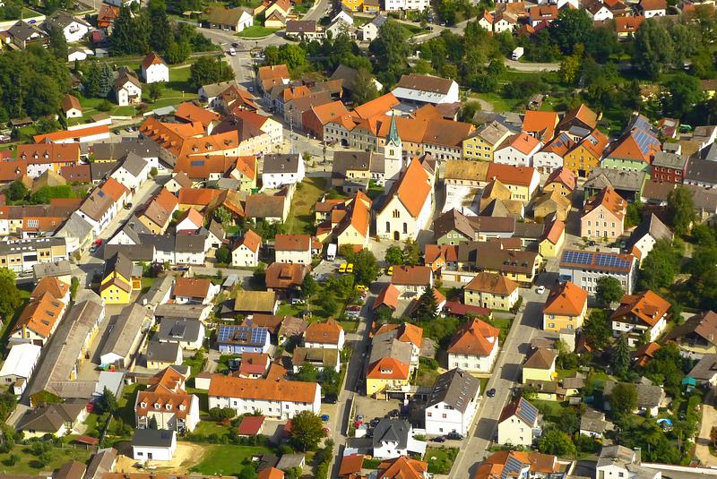
After this the riders head into the valley of the Regen river, a tributary of the Danube. This is close to where it flows into the larger river and the valley it cuts is deep enough to add a couple of climbs to the top of the valley ridge to the stage. Both are fairly consistent and neither are especially threatening, but with the latter, coming after the scenic village of Regenstauf, ending with 25km remaining, there is the potential somebody may take a flyer if the break is within reach or has been caught early.
The first part of the descent after a rolling phase atop the climb is quite twisty, but it opens out lower down. There is then an uncategorised climb cresting 8,1km from the finish which could be used as a fulcrum to attack if the group is reduced or if the break is looking like staying away, before crossing the Danube itself in the final kilometre for a frenetic last rush to a finish on a wide open street adjacent to Regensburg's UNESCO World Heritage site inner city, one of very few preserved medieval old towns north of the Alps, also containing some remainder of the city's Roman heritage. This will be a scenic run-in and provide some interesting camera views if it is a tedious sprint stage; the stage will, however, be more likely to favour a durable sprinter like Degenkolb or Kristoff than a pure flat engine like Kittel; Greipel may fight to be there but perhaps Germany's most likely winners other than Degenkolb would be Rüdiger Selig or Gerald Ciolek... but how's about this for a finishing straight?

1) Dresden - Dresden ITT with a cobbled climb at the start
2) Chemnitz - Halle with a large number of cobbled sectors
3) Magdeburg - Buchholz/Nordheide with a couple of cobbled sectors near the end
4) Verden - Clausthal-Zellerfeld a flat stage with a couple of smallish climbs late on
5) Göttingen - Winterberg a tough intermediate stage with a lot of up and down
6) Frankenberg/Eder - Königstein/Taunus an intermediate stage with a long gradual climb followed by a short steep puncheur's finale
7) Hanau - Schleusingen a medium mountain stage with a range of potential outcomes and a cat.2 25km out.
Stage 8: Bayreuth - Regensburg, 179km
GPM:
Koppelberg (cat.3) 3,1km @ 5,1%
Löffelsberg (cat.4) 1,9km @ 4,6%
Tannenberg (cat.4) 1,5km @ 8,8%
Wundsheimer Sender (cat.4) 1,9km @ 8,5%
Eckartsreuth (cat.4) 2,8km @ 5,1%
Schneitweg (cat.3) 3,2km @ 5,0%
A slightly odd choice of stage for a weekend, you may point out, but I will also point out in response that we are trying to capitalise on Germany's rekindled interest in cycling, and so a stage that offers potential interest but also gives a good chance of a home triumph (depending on the audience's feelings regarding Bavarian regional identity of course), which with Germany's biggest names in the sport bar one being sprinters at the moment rather limits things.
This is also a stage steeped in cultural history, as it links two UNESCO World Heritage sites and will give some pretty impressive scenery to look at during the stage as we head through eastern Bavaria. The départ fictif will be from in front of the Margravia Opernhaus, the stunning baroque opera tied to the city's heritage.
The neutral zone will feature an out-and-back to the Festspielhaus, built for the performance of Wagner's work owing to the orchestra pit at the traditional Opernhaus not being able to accommodate the multitude of musicians needed for his work. Though not from Bayreuth, the city has become synonymous with Wagner, and both he and Franz Liszt (whose daughter was married to Wagner) are buried in the city. The Nazis tried to turn it into the model German city (to their model, anyway) and it was especially popular with the party, owing in part to Hitler's love of Wagner; however it was also a city where the synagogue was allowed to be left standing as its proximity to the Opernhaus made razing it risky.
The actual stage is mostly rolling and southbound through eastern Bavaria, running mostly parallel to the Czech border. A couple of the climbs are relatively steep, the Tannenberg and the Wundsheimer Sender, both of which are short and feature gradients of up to 15%, but which are both categorized only 4 owing to their distance from the finish. Nevertheless, there are a lot of small mountain points to duke out today, so a rider looking to safeguard a lead or get a day in the jersey could fight these out.
The main body of the stage is the stretch after the town of Bruck in der Oberpfalz.
After this the riders head into the valley of the Regen river, a tributary of the Danube. This is close to where it flows into the larger river and the valley it cuts is deep enough to add a couple of climbs to the top of the valley ridge to the stage. Both are fairly consistent and neither are especially threatening, but with the latter, coming after the scenic village of Regenstauf, ending with 25km remaining, there is the potential somebody may take a flyer if the break is within reach or has been caught early.
The first part of the descent after a rolling phase atop the climb is quite twisty, but it opens out lower down. There is then an uncategorised climb cresting 8,1km from the finish which could be used as a fulcrum to attack if the group is reduced or if the break is looking like staying away, before crossing the Danube itself in the final kilometre for a frenetic last rush to a finish on a wide open street adjacent to Regensburg's UNESCO World Heritage site inner city, one of very few preserved medieval old towns north of the Alps, also containing some remainder of the city's Roman heritage. This will be a scenic run-in and provide some interesting camera views if it is a tedious sprint stage; the stage will, however, be more likely to favour a durable sprinter like Degenkolb or Kristoff than a pure flat engine like Kittel; Greipel may fight to be there but perhaps Germany's most likely winners other than Degenkolb would be Rüdiger Selig or Gerald Ciolek... but how's about this for a finishing straight?
- Oct 12, 2013
- 2,430
- 31
- 6,530
Giro d'Italia
And now ... a Giro! It might be overkill to do a Giro while the Race Design Challenge is underway, but at least i can promise that my Giro is different. All the major stages, and even the minor ones, have no similarity to the stages in Eshnar's challenge so far. While i did use a few famous climbs, for the most part i went for underused and maybe not well known climbs. There is no Mortirolo, no Gavia, no Stelvio, no Zoncolan, no Pordoi and - gasp - no Fedaia in my Giro. No reason to kill kittens though, the mountain stages will be sufficiently hard. There will also be easier stages of course, even some for the sprinters, and a sterrato stage i'm quite proud of.
(Sat) prologue: Napoli, 3,8 km


The whole first week takes place in the South, therefore it makes sense to start the Giro in the charming and troubled capital city of the South, Napoli. It is a very short prologue at just 3,8 km where sprinters should have a good chance to compete with the time trial specialists. The latter should not despair, as there is a long flattish time trial coming up at the end of the first week with not too much climbing in between.

The prologue starts at Via Francesco Caracciolo with nice buildings to the left, the sea to the right and Vesuvio in the background. The riders will ride directly along the sea until they reach Castel dell'Ovo, the oldest standing fortification in Napoli. Then the cobbled Via Cesario Console will take them to the finish at the huge Piazza del Plebiscito.


And now ... a Giro! It might be overkill to do a Giro while the Race Design Challenge is underway, but at least i can promise that my Giro is different. All the major stages, and even the minor ones, have no similarity to the stages in Eshnar's challenge so far. While i did use a few famous climbs, for the most part i went for underused and maybe not well known climbs. There is no Mortirolo, no Gavia, no Stelvio, no Zoncolan, no Pordoi and - gasp - no Fedaia in my Giro. No reason to kill kittens though, the mountain stages will be sufficiently hard. There will also be easier stages of course, even some for the sprinters, and a sterrato stage i'm quite proud of.
(Sat) prologue: Napoli, 3,8 km
The whole first week takes place in the South, therefore it makes sense to start the Giro in the charming and troubled capital city of the South, Napoli. It is a very short prologue at just 3,8 km where sprinters should have a good chance to compete with the time trial specialists. The latter should not despair, as there is a long flattish time trial coming up at the end of the first week with not too much climbing in between.
The prologue starts at Via Francesco Caracciolo with nice buildings to the left, the sea to the right and Vesuvio in the background. The riders will ride directly along the sea until they reach Castel dell'Ovo, the oldest standing fortification in Napoli. Then the cobbled Via Cesario Console will take them to the finish at the huge Piazza del Plebiscito.
- Oct 12, 2013
- 2,430
- 31
- 6,530
Giro d'Italia
(Sun) stage 1: Napoli - Napoli, 169 km


It is not unusual that the first two days are held in the same city, we have seen this lately with Belfast and Herning. In this case we won't even leave the city borders, as we are doing a circuit race on a quite demanding course in Napoli. It is Sunday after all, and there should be huge crowds. The start is by the seafront, as there is more place for the team busses. The riders will climb up the hill to the finish line and will then do 12 laps of the 13,6 km circuit.

The first part of the descent is partly on cobbles, but these are the harmless sort and will feature a lot today. The descent leads to Corso Vittorio Emanuele, which is a sort of balcony mid-town.

A hairpin in front of Castello Aselmeyer marks the beginning of the second part of the descent, which brings us back to the seafront.

After a few flat kilometers, including the impressive Viale Antonio Gramsci, the climb to Vomero has to be tackled. It is 2,7 km long and has an average gradient of 6%. But as you can see from the profile, it is very irregular, steeper bits are alternating with nearly flat parts. The road is quite big at first, but at km 10,7 we take a smaller road, which twists and turns up the hill between nice villas.

This is followed by an easier stretch, which however provides nice views of Napoli and its Gulf.

The hardest part of the climb begins at km 12,1, when we take Via Kagoshima. The next 300 meters are 10% steep and will without doubt be an ideal place to attack, especially as there is only a bit more than a kilometer left to the finish line at Via Alessandro Scarlatti.


(looking back the finishing straight)
This is no easy circuit with the total climbing amounting to 3.040 meters, but not a super hard one either. There certainly will be some gaps made in the last round, even though the stage win will probably go to a puncheur like Gilbert.
(Sun) stage 1: Napoli - Napoli, 169 km
It is not unusual that the first two days are held in the same city, we have seen this lately with Belfast and Herning. In this case we won't even leave the city borders, as we are doing a circuit race on a quite demanding course in Napoli. It is Sunday after all, and there should be huge crowds. The start is by the seafront, as there is more place for the team busses. The riders will climb up the hill to the finish line and will then do 12 laps of the 13,6 km circuit.
The first part of the descent is partly on cobbles, but these are the harmless sort and will feature a lot today. The descent leads to Corso Vittorio Emanuele, which is a sort of balcony mid-town.
A hairpin in front of Castello Aselmeyer marks the beginning of the second part of the descent, which brings us back to the seafront.
After a few flat kilometers, including the impressive Viale Antonio Gramsci, the climb to Vomero has to be tackled. It is 2,7 km long and has an average gradient of 6%. But as you can see from the profile, it is very irregular, steeper bits are alternating with nearly flat parts. The road is quite big at first, but at km 10,7 we take a smaller road, which twists and turns up the hill between nice villas.
This is followed by an easier stretch, which however provides nice views of Napoli and its Gulf.
The hardest part of the climb begins at km 12,1, when we take Via Kagoshima. The next 300 meters are 10% steep and will without doubt be an ideal place to attack, especially as there is only a bit more than a kilometer left to the finish line at Via Alessandro Scarlatti.
(looking back the finishing straight)
This is no easy circuit with the total climbing amounting to 3.040 meters, but not a super hard one either. There certainly will be some gaps made in the last round, even though the stage win will probably go to a puncheur like Gilbert.
- Sep 28, 2014
- 3,639
- 1,608
- 16,680
How do you get map like that?jsem94 said:A conclusive map:

A total of 1270km of racing, including more than 175km of sterrato.
- Feb 18, 2015
- 13,852
- 9,904
- 28,180
Re:
And just in case you didnt know, there is a race design challenge in the games section of the forum

My comment wasnt meant that way if you write this because of it. I love giro's and it will always be the gt I enjoy the most to design, but at the moment I see 7 different giro stages every second day and it feels like I have seen any little bump of italy in the last month.Valv.Piti said:fauniera: I find a Giro 100x more interesting than some stage race in the UK. Keep it up, I'll follow it for sure.
And just in case you didnt know, there is a race design challenge in the games section of the forum
Is it possible that you didnt follow the thread after the update? Libertine tries to recreate the Library but thats more than a lot of work, so we probably have to wait for a whilejsem94 said:Libertine, if you wouldn't mind?
I know it's a pain in the ass, but it'd be nice to have a functioning library.
Photo editing it looks like, very well done.lemon cheese cake said:How do you get map like that?jsem94 said:A conclusive map:
A total of 1270km of racing, including more than 175km of sterrato.
- Aug 21, 2015
- 380
- 0
- 9,280
Cronoescalada moved the zoom and street view buttons!!!
They are now along the upper left side under the option to go to satellite or map mode. Still no zoom slider but really happy to see this at least as it makes it a lot easier to go through stuff on my lap top.
They are now along the upper left side under the option to go to satellite or map mode. Still no zoom slider but really happy to see this at least as it makes it a lot easier to go through stuff on my lap top.
TRENDING THREADS
-
-

-
 Milan San Remo, March 21, 2026, 298 km monument
- Started by topcat
- Replies: 1K
-

-
 Teams & Riders The Remco Evenepoel is the next Eddy Merckx thread
- Started by DNP-Old
- Replies: 38K
-
 Teams & Riders Tadej Pogačar discussion thread
- Started by Lequack
- Replies: 43K
-

Cyclingnews is part of Future plc, an international media group and leading digital publisher. Visit our corporate site.
© Future Publishing Limited Quay House, The Ambury, Bath BA1 1UA. All rights reserved. England and Wales company registration number 2008885.