
Race Design Thread
Page 212 - Get up to date with the latest news, scores & standings from the Cycling News Community.
You are using an out of date browser. It may not display this or other websites correctly.
You should upgrade or use an alternative browser.
You should upgrade or use an alternative browser.
- Feb 20, 2012
- 55,436
- 46,755
- 28,180
33% on that shows on a segment likely has even steeper pitches. I don't think that's doable. I don't think we should aim to go over 25-27%. But 33% on such a climb is too much.
THough I do guess that if you just have ridiculously light gears you should be able to manage?
THough I do guess that if you just have ridiculously light gears you should be able to manage?
- Feb 20, 2010
- 33,229
- 15,743
- 28,180
And I'm at the exact opposite end of the spectrum...
Stage 12: Benifaió - Valencia, 43,6km (CRI)


We haven't had a test against the clock since the opening team time trial, and so it's high time that we give the chrono specialists a chance to shine - they need to prepare for the Worlds too, you know. And with there having been a few mountains thus far in the race - and more to come of course - we need to balance things out. And what better way than a good length, pan-flat time trial to let the power rouleurs really put down the power and prevent the pint-sized grimpeurs having the opportunity to limit their losses?

The riders set off from the Ribera Alta town of Benifaió (also sometimes called Benifayó), one of the many satellite towns to the capital of the Comunidad Valenciana, which has as its centrepiece the preserved Moorish tower you see above. The town was also the home of former pro Salvador Botella, who twice won the Volta a Catalunya and won several stages of the Vuelta and Giro back in the 50s and early 60s, prior to his death in 2006. We do a bit of looping back and forth around the surrounding towns before crossing over the autovía and the train lines, taking us into the Parc Natural de l'Albufera, a large freshwater lagoon and estuary that is also a protected wetland.

At the time of year of the race it will resemble the above, but at other times it, like most wetlands, becomes full of water meadows; as you might expect from somewhere so naturally filling with water, it is perfectly level. It is a very popular area for bird-watching, but also it is an important fishing area, both for hobby and commercial interests. Another key development is the suitability of the wetlands for rice-growing; this has been important in the development of that internationally-recognized symbol of Spain, the regional speciality that is paella valenciana. It will also give us some pleasing helicam footage while the riders are pummelling themselves along the coastal roads.
Once we enter the regional capital, the route is rather similar to the 2009 Vuelta time trial which was effectively a 35km out-and-back which was won by Fabian Cancellara, because it was 2009 so of course it was. You can see it here. The route also finished with a lap of the Valencia Street Circuit, an emblematic Grand Prix white elephant - the high sided walled-in nature of the track created a tunnel effect that made slipstreaming nigh on impossible and led to processional and dull races, while the purpose-built "street circuit" that surrounded the harbour actually had, for most of its length, billiard-table smooth tarmac and wide open corners with large run-off areas, thus erasing any of the usual challenges of street circuits. It was never to be confused with the much more interesting Circuito de Valencia, a permanent venue in nearby Cheste used for motorcycle racing. Its entire raison d'être was to capitalize on the popularity of Fernando Alonso; with his successes becoming more infrequent and with Catalunya already on the calendar and more oil-rich countries wanting to muscle in on the calendar, it was quickly forgotten and fell into fairly grim disrepair - not being a permanent facility meant that it couldn't make the upkeep costs by hosting other series, while not being a true temporary facility means much of it is not in "normal use" either. However, with the harbourside development projects continuing and the water-front areas still looking glamorous, it's also ideal in that it can be a city centre finish readily accessible but also requiring minimal disruption. The photo below shows the area this time last year, so it is still in decent enough nick to host a bike race. After all, the dismantled stands etc. are not an issue; a cyclist does not need anything like the width of an F1 track so conventional barriers from every cycling race you've ever watched will suffice as the fans can stand on the edges of the former track rather than in the stand areas.

Stage 12: Benifaió - Valencia, 43,6km (CRI)
We haven't had a test against the clock since the opening team time trial, and so it's high time that we give the chrono specialists a chance to shine - they need to prepare for the Worlds too, you know. And with there having been a few mountains thus far in the race - and more to come of course - we need to balance things out. And what better way than a good length, pan-flat time trial to let the power rouleurs really put down the power and prevent the pint-sized grimpeurs having the opportunity to limit their losses?
The riders set off from the Ribera Alta town of Benifaió (also sometimes called Benifayó), one of the many satellite towns to the capital of the Comunidad Valenciana, which has as its centrepiece the preserved Moorish tower you see above. The town was also the home of former pro Salvador Botella, who twice won the Volta a Catalunya and won several stages of the Vuelta and Giro back in the 50s and early 60s, prior to his death in 2006. We do a bit of looping back and forth around the surrounding towns before crossing over the autovía and the train lines, taking us into the Parc Natural de l'Albufera, a large freshwater lagoon and estuary that is also a protected wetland.
At the time of year of the race it will resemble the above, but at other times it, like most wetlands, becomes full of water meadows; as you might expect from somewhere so naturally filling with water, it is perfectly level. It is a very popular area for bird-watching, but also it is an important fishing area, both for hobby and commercial interests. Another key development is the suitability of the wetlands for rice-growing; this has been important in the development of that internationally-recognized symbol of Spain, the regional speciality that is paella valenciana. It will also give us some pleasing helicam footage while the riders are pummelling themselves along the coastal roads.
Once we enter the regional capital, the route is rather similar to the 2009 Vuelta time trial which was effectively a 35km out-and-back which was won by Fabian Cancellara, because it was 2009 so of course it was. You can see it here. The route also finished with a lap of the Valencia Street Circuit, an emblematic Grand Prix white elephant - the high sided walled-in nature of the track created a tunnel effect that made slipstreaming nigh on impossible and led to processional and dull races, while the purpose-built "street circuit" that surrounded the harbour actually had, for most of its length, billiard-table smooth tarmac and wide open corners with large run-off areas, thus erasing any of the usual challenges of street circuits. It was never to be confused with the much more interesting Circuito de Valencia, a permanent venue in nearby Cheste used for motorcycle racing. Its entire raison d'être was to capitalize on the popularity of Fernando Alonso; with his successes becoming more infrequent and with Catalunya already on the calendar and more oil-rich countries wanting to muscle in on the calendar, it was quickly forgotten and fell into fairly grim disrepair - not being a permanent facility meant that it couldn't make the upkeep costs by hosting other series, while not being a true temporary facility means much of it is not in "normal use" either. However, with the harbourside development projects continuing and the water-front areas still looking glamorous, it's also ideal in that it can be a city centre finish readily accessible but also requiring minimal disruption. The photo below shows the area this time last year, so it is still in decent enough nick to host a bike race. After all, the dismantled stands etc. are not an issue; a cyclist does not need anything like the width of an F1 track so conventional barriers from every cycling race you've ever watched will suffice as the fans can stand on the edges of the former track rather than in the stand areas.
- Jun 30, 2014
- 7,060
- 2
- 0
Re:
Yeah, those gradients are a bit over the top, but the Muro ends with 3.5km to go and you have the crazy steep section at the beginning of the Muro, I think it could work.Red Rick said:33% on that shows on a segment likely has even steeper pitches. I don't think that's doable. I don't think we should aim to go over 25-27%. But 33% on such a climb is too much.
THough I do guess that if you just have ridiculously light gears you should be able to manage?
- Feb 20, 2012
- 55,436
- 46,755
- 28,180
Also depends on the length of the section. If the steepest pitch isn't too long, you can get away with more then if it it's longer or when you're already on the limit when you get there. If you look at this particular climb, it's 33% for more than 200m, which may seem short but it's gonna take almost 2 minutes.
Then again, I think the steepest gradients of a lot of climbs are actually overstated.
Then again, I think the steepest gradients of a lot of climbs are actually overstated.
- Feb 20, 2010
- 33,229
- 15,743
- 28,180
Stage 13: Valencia - Castellón de la Plana, 146km


GPM:
Puerto del Oronet (cat.3) 8,6km @ 3,8%
Alto Desierto de las Palmas (cat.2) 7,8km @ 5,1%
Yes, this is a bit of a strange one from me - an absolute carbon copy of stage 10 of the 2015 Vuelta, a short and fast stage with a second category bump near the end to try to break things up.
The main reason for this is that the Vuelta does like, if something works, to go back to that well again; for example, the Almería-Calar Alto stages mentioned a few stages ago were absolutely identical, as were the 2011 and 2013 Angliru stages. In less direct senses, they did return to Xorret del Catí in 2009 after a long lay-off and promptly go back the very next year, while in 2010 the same applied to Peña Cabarga - and the brand new Valdepeñas de Jaén muro was brought back the following year as well. Therefore it's not so much of a problem given that I'm racing northwards along the coast from Valencia to repeat a stage such as this; in the end, that stage produced some pretty entertaining racing although the (massively thinned out) bunch won out in the end.
Although it has a ramp of 11%, the only early climb of the day, the Puerto del Oronet isn't going to cause anybody any real trouble; certainly a finish around here would much better suit a descent into Sagunt from Garbí, which could make a very good intermediate stage, but here we're just starting out so no need for that.

La Vall d'Uixó is the next stop off; it hosted the national time trials in 2011 and was a stage start in the Valdelinares stage of my "best medium mountain race ever!" Vuelta. Its main claim to fame is related to its underground river and extensive cave network. From here, however, it's pan-flat as we pass our finishing city for the first time and head to the coast, where we head to the city of Benicàssim, which hosts the second intermediate sprint just before the start of the final climb.
We were introduced to this run-in before the 2015 Vuelta, however, as it featured as the key decisive factor in the 2011 Spanish national championships where they took on today's finishing circuit three times. If anything the circuit was slightly longer than today's but not in respect of the distance from the climb to the finish. That day, José Joaquín Rojas emerged triumphant after he stayed with Contador's attacks on the climb to Desierto de las Palmas, and with Movistar not wanting to chase as they finally had found a sprint even Rojas couldn't come 4th in, they were allowed to go with only Euskaltel chasing.

The road that snakes up to the Monastério del Desierto de las Palmas is a scenic one, but it's not without its challenges. It's basically the first 7,8km of this profile, which as you can see means about 6km at 6% followed by a flattening out then a final little ramp to the summit. No real steep ramps, and with the penultimate weekend coming attacks from the big names are unlikely (even with the finishing line less than 20km from the summit) however secondary threats, Worlds preparation riders (rather like Terpstra's attempted solo last year or the infamous Tony Martin stage) and teams with nothing from the race yet will certainly help liven up proceedings. It's a short stage the day after a long TT and the sprinters will have to be on their toes, because it's going to be a while before they get another stage as tempting as this one...

GPM:
Puerto del Oronet (cat.3) 8,6km @ 3,8%
Alto Desierto de las Palmas (cat.2) 7,8km @ 5,1%
Yes, this is a bit of a strange one from me - an absolute carbon copy of stage 10 of the 2015 Vuelta, a short and fast stage with a second category bump near the end to try to break things up.
The main reason for this is that the Vuelta does like, if something works, to go back to that well again; for example, the Almería-Calar Alto stages mentioned a few stages ago were absolutely identical, as were the 2011 and 2013 Angliru stages. In less direct senses, they did return to Xorret del Catí in 2009 after a long lay-off and promptly go back the very next year, while in 2010 the same applied to Peña Cabarga - and the brand new Valdepeñas de Jaén muro was brought back the following year as well. Therefore it's not so much of a problem given that I'm racing northwards along the coast from Valencia to repeat a stage such as this; in the end, that stage produced some pretty entertaining racing although the (massively thinned out) bunch won out in the end.
Although it has a ramp of 11%, the only early climb of the day, the Puerto del Oronet isn't going to cause anybody any real trouble; certainly a finish around here would much better suit a descent into Sagunt from Garbí, which could make a very good intermediate stage, but here we're just starting out so no need for that.
La Vall d'Uixó is the next stop off; it hosted the national time trials in 2011 and was a stage start in the Valdelinares stage of my "best medium mountain race ever!" Vuelta. Its main claim to fame is related to its underground river and extensive cave network. From here, however, it's pan-flat as we pass our finishing city for the first time and head to the coast, where we head to the city of Benicàssim, which hosts the second intermediate sprint just before the start of the final climb.
We were introduced to this run-in before the 2015 Vuelta, however, as it featured as the key decisive factor in the 2011 Spanish national championships where they took on today's finishing circuit three times. If anything the circuit was slightly longer than today's but not in respect of the distance from the climb to the finish. That day, José Joaquín Rojas emerged triumphant after he stayed with Contador's attacks on the climb to Desierto de las Palmas, and with Movistar not wanting to chase as they finally had found a sprint even Rojas couldn't come 4th in, they were allowed to go with only Euskaltel chasing.
The road that snakes up to the Monastério del Desierto de las Palmas is a scenic one, but it's not without its challenges. It's basically the first 7,8km of this profile, which as you can see means about 6km at 6% followed by a flattening out then a final little ramp to the summit. No real steep ramps, and with the penultimate weekend coming attacks from the big names are unlikely (even with the finishing line less than 20km from the summit) however secondary threats, Worlds preparation riders (rather like Terpstra's attempted solo last year or the infamous Tony Martin stage) and teams with nothing from the race yet will certainly help liven up proceedings. It's a short stage the day after a long TT and the sprinters will have to be on their toes, because it's going to be a while before they get another stage as tempting as this one...
- Oct 4, 2015
- 417
- 1
- 3,030
Starting off my "challenge" with the Vuelta a la Comunidad de Madrid.
The real-life Vuelta a la Comunidad de Madrid has been victim of a troubled organization recently, with the 2014 edition not being held. In recent years at least, the race has usually featured a mountain stage (often finishing at Puerto de la Morcuera), a flat circuit stage and/or a short time trial, the latter two being held in the same day when both were held.
My version of the race features three stages: a flat prologue, followed by a tough mountain stage in the Sierra de Madrid, and then a medium mountain route around San Lorenzo de El Escorial replacing the typical Madrid circuit.
Vuelta a la Comunidad de Madrid Stage 1: Pinto - Pinto, 8km (ITT)


The race starts with a very short time trial around Pinto, Alberto Contador's birthplace. The stage is flat with long straights, so power TTers will get a small head start here.
The real-life Vuelta a la Comunidad de Madrid has been victim of a troubled organization recently, with the 2014 edition not being held. In recent years at least, the race has usually featured a mountain stage (often finishing at Puerto de la Morcuera), a flat circuit stage and/or a short time trial, the latter two being held in the same day when both were held.
My version of the race features three stages: a flat prologue, followed by a tough mountain stage in the Sierra de Madrid, and then a medium mountain route around San Lorenzo de El Escorial replacing the typical Madrid circuit.
Vuelta a la Comunidad de Madrid Stage 1: Pinto - Pinto, 8km (ITT)
The race starts with a very short time trial around Pinto, Alberto Contador's birthplace. The stage is flat with long straights, so power TTers will get a small head start here.
- Oct 4, 2015
- 417
- 1
- 3,030
Vuelta a la Comunidad de Madrid Stage 2: Alcobendas - Valdesquí, 173km


Next comes the mountain stage in the Sierra de Madrid, with a summit finish in Valdesquí, one of the two most important ski stations near Madrid (the other being Navacerrada).
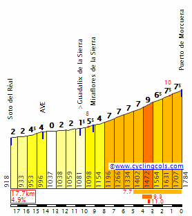
The climb to Valdesquí is pretty much the same as Puerto de Cotos, followed by 2,5 slightly uphill kms. It's a long and gradual climb, possibly not steep enough to create very big gaps on its own... but it's preceded by 6 categorized climbs, including the difficult Puerto de la Morcuera, which comes immediately before the final climb. If the pace is high (and specialists at long, gradual climbs will want it to be), then we may see important time gaps here, or at the very least an important selection of the contenders before the third and final stage of the race.
Next comes the mountain stage in the Sierra de Madrid, with a summit finish in Valdesquí, one of the two most important ski stations near Madrid (the other being Navacerrada).
The climb to Valdesquí is pretty much the same as Puerto de Cotos, followed by 2,5 slightly uphill kms. It's a long and gradual climb, possibly not steep enough to create very big gaps on its own... but it's preceded by 6 categorized climbs, including the difficult Puerto de la Morcuera, which comes immediately before the final climb. If the pace is high (and specialists at long, gradual climbs will want it to be), then we may see important time gaps here, or at the very least an important selection of the contenders before the third and final stage of the race.
- Oct 4, 2015
- 417
- 1
- 3,030
Vuelta a la Comunidad de Madrid Stage 3: San Lorenzo de El Escorial - San Lorenzo de El Escorial, 163km


The race ends with another summit finish, this time in San Lorenzo de El Escorial. However, this time the finish is pretty much the opposite of the previous stage, as the final climb is the very short and extremely steep climb first used in the 2011 Vuelta stage to San Lorenzo de El Escorial. In fact, the final 22km of this stage are exactly the same as in the 2011 stage.

The stage itself has a lot of categorized climbs, but all of them are short and not too steep (except the two passes through the Escorial wall, of course). Most attacks will probably be limited to the final ascent, but the explosive climbers will probably want to keep pace high throughout, particularly in the first pass through the brutal slopes at Escorial, to try and drop the "diesel" climbers that may have gained time over the rest in the Valdesquí stage.
The race ends with another summit finish, this time in San Lorenzo de El Escorial. However, this time the finish is pretty much the opposite of the previous stage, as the final climb is the very short and extremely steep climb first used in the 2011 Vuelta stage to San Lorenzo de El Escorial. In fact, the final 22km of this stage are exactly the same as in the 2011 stage.
The stage itself has a lot of categorized climbs, but all of them are short and not too steep (except the two passes through the Escorial wall, of course). Most attacks will probably be limited to the final ascent, but the explosive climbers will probably want to keep pace high throughout, particularly in the first pass through the brutal slopes at Escorial, to try and drop the "diesel" climbers that may have gained time over the rest in the Valdesquí stage.
- Feb 20, 2010
- 33,229
- 15,743
- 28,180
That's a nice mountain stage for a short stage race, not so difficult that it annihilates the field at a .1 race but tough enough to break up the race. Only surprise is no La Trampa before the first time to Bustarviejo, which is seemingly a traceur favourite chain (La Trampa-Bustarviejo-Morcuera south). Valdesquí is quite conveniently located there as the final climb is the easier of the two 'big' climbs in the stage. You have noted the climb at the town of Navacerrada as the Puerto de Navacerrada though, which is a bit misleading given that's the name of the pass at the ski station. San Lorenzo is an excellent location for a hilly stage and it's a bit strange that the Vuelta a Madrid doesn't use it to be honest.
Stage 14: Benicàssim - Mont Carò, 152km


GPM:
Mont Carò (cat.ESP) 23,2km @ 6,1%
We're still over by the eastern coast as we head into the penultimate weekend, and it's Saturday, so it's time for possibly the number one stage in this edition of the Vuelta to keep Javier Guillén happy. All too much of the climbing in this race will be on fairly agreeable, classic mountains (long, mid gradient) and compared to recent real-life Vueltas (and the last two editions of mine) little in the way of La Camperona styled hell-slopes. I've also worked to chain climbs together leading to a couple of stages which I think could be classic mountain stage designs, so providing something like this - a pure Unipuerto one-climb stage of barely 150km in length - is both a rarity and a bit of a cop-out. But then, it is only the second ESP climb of the race and a mountaintop finish, so there should be gaps nevertheless.

It's a very short transfer (enough to be almost nothing really) to Benicàssim from Castellón - it was on the circuit yesterday, hosting an intermediate sprint directly before the Desierto de las Palmas climb. It's another beach resort type place although it also has another claim to fame, hosting a sizable music festival which takes place in July and is one of the biggest on the Iberian peninsula. Both Benicàssim and Castellón have plenty of options for the teams to stay at so this should be pretty easily doable. The riders' first difficulty of the day is the uncategorized undulating roads over the Mirador del Oropesa to Oropesa del Mar; the riders will be slightly inland from the Vía Verde shown below, but this gives you an idea of the scenery the early parts of the stage entail.

For the first 60km or so the riders will be slightly inland, but we turn to the sea and arrive on the coast road in Peñíscola with its fortified off-shore castle, and from here the middle part of the stage is all about the Costa del Azahar, until we cross over from Comunidad Valenciana into Catalunya and it becomes the Costa Daurada at Alcanar. After three days in the Valencia region (one each in Alicante, Valencia and Castellón province) as we head to the penultimate weekend we're heading into Catalunya, but for the moment we're still in the Sistema Ibérico, so when we head inland for Tortosa, the mountain options are comparatively limited when you think of other areas in the autonomous region.

This scenic city of around 30.000 inhabitants has rather been lost to cycling since 1999, when the Volta a Catalunya stopped by (I really must do a Volta a Catalunya at some point, I've started about ten and never finished one I'm happy with... too many choices) but that was for a pure sprint stage (as evidenced by the fact it was won by the Lion King himself, Mario Cipollini). Here we continue on past the city, for it is here that the road takes a turn for the horrible, and we climb the monster Mont Carò.
Mont Carò is the highest mountain of Els Ports (more formally Els Ports de Tortosa-Beselt), close to the northeasternmost tip of the Sistema Ibérico, those massifs and highlands that dot north-east-central Spain and provide a few of the areas used in between the Pyrenees, the Basque mountains and Sierra Cantabria and the Sierra de Madrid and the wider Sistema Central. The most famous parts of the Sistema for cycling fans are probably those to the westernmost edge, which include the climbs around eastern Burgos and southern La Rioja, giving us former Vuelta classics like Cruz de la Demanda (climbed several times in the 90s, won by Tony Rominger, Alex Zülle and most recently in 2001 by Chava Jiménez, the first of three stage wins in the legendary climber's last stand) and Valdezcaray (won by Kelly in 1988 and Parra in 1991, brought back in 2012 and won from the break by Simon Clarke), and the Burgos tradition that is Lagunas de Neila (only used once by La Vuelta, strangely enough, in 1998, won by the aforementioned Jiménez). The more central part of the range is probably most famous for the Valdelinares climb used by the Vuelta in 2005 (won by Heras) and 2014 (won by Winner Anacona).
And yet, this climb, which may actually be the hardest climb in the entire mountain range, remains unknown to its La Vuelta. It has been used twice in the Volta a Catalunya, however - first in 1985, when race leader Vicente Belda and his teammate Alirio Chizabas got away; Belda gifted the Colombian the stage, but lost the lead in the following day's time trial to Robert Millar; and then in 1991, when the mythical climber Lucho Herrera took the stage, setting an infernal pace dropping race leader Indurain and pulling Perico Delgado and Piotrs Ugrumovs with him before dropping them to take the win solo. But since then... nothing.

These terrifying switchbacks and hard gradients do have a problem for race designers; much like Mont Ventoux, there are no other climbs of even remotely comparable difficulty nearby, so a stage finishing here will almost inevitably be a one-climb affair. Even more so than Jito d'Escarandí, another great Spanish climb that was ruined by poor racing on its introduction to the Vuelta in last year's edition, and so, truth be told, I'm a little concerned that the riders may ruin this stage. But I also have confidence in Mont Carò's ability to create gaps. The last 15km average 7,5% and there is very little in the way of respite, as you can see from the profile:

Yes, there is the fear that riders will wait until the two kilometres at almost 10% around 4km from home to attack, but with the number of tramos of 10% or more in the earlier phase of the climb I really hope we are going to see some action before that even if it's from secondary contenders. This is about parcours design 101; if today's stage didn't end in a mountaintop finish it would probably get soft-pedalled so we need to ensure the pace is infernal here. Everyone's going to hit Tortosa fresh, so it should be a power-meter-breaking sprint up this 23km of pain with the Mediterranean in the background.

At the top there's a signal station; it's comparatively small but the Vuelta has finished in much smaller places of late anyway, and besides, you can see on the profile the turn-off for an Área Recreativa 4km from the line, so much of the caravan can wait there. And besides, it's hosted top level cycling before!

Stage 14: Benicàssim - Mont Carò, 152km
GPM:
Mont Carò (cat.ESP) 23,2km @ 6,1%
We're still over by the eastern coast as we head into the penultimate weekend, and it's Saturday, so it's time for possibly the number one stage in this edition of the Vuelta to keep Javier Guillén happy. All too much of the climbing in this race will be on fairly agreeable, classic mountains (long, mid gradient) and compared to recent real-life Vueltas (and the last two editions of mine) little in the way of La Camperona styled hell-slopes. I've also worked to chain climbs together leading to a couple of stages which I think could be classic mountain stage designs, so providing something like this - a pure Unipuerto one-climb stage of barely 150km in length - is both a rarity and a bit of a cop-out. But then, it is only the second ESP climb of the race and a mountaintop finish, so there should be gaps nevertheless.
It's a very short transfer (enough to be almost nothing really) to Benicàssim from Castellón - it was on the circuit yesterday, hosting an intermediate sprint directly before the Desierto de las Palmas climb. It's another beach resort type place although it also has another claim to fame, hosting a sizable music festival which takes place in July and is one of the biggest on the Iberian peninsula. Both Benicàssim and Castellón have plenty of options for the teams to stay at so this should be pretty easily doable. The riders' first difficulty of the day is the uncategorized undulating roads over the Mirador del Oropesa to Oropesa del Mar; the riders will be slightly inland from the Vía Verde shown below, but this gives you an idea of the scenery the early parts of the stage entail.
For the first 60km or so the riders will be slightly inland, but we turn to the sea and arrive on the coast road in Peñíscola with its fortified off-shore castle, and from here the middle part of the stage is all about the Costa del Azahar, until we cross over from Comunidad Valenciana into Catalunya and it becomes the Costa Daurada at Alcanar. After three days in the Valencia region (one each in Alicante, Valencia and Castellón province) as we head to the penultimate weekend we're heading into Catalunya, but for the moment we're still in the Sistema Ibérico, so when we head inland for Tortosa, the mountain options are comparatively limited when you think of other areas in the autonomous region.
This scenic city of around 30.000 inhabitants has rather been lost to cycling since 1999, when the Volta a Catalunya stopped by (I really must do a Volta a Catalunya at some point, I've started about ten and never finished one I'm happy with... too many choices) but that was for a pure sprint stage (as evidenced by the fact it was won by the Lion King himself, Mario Cipollini). Here we continue on past the city, for it is here that the road takes a turn for the horrible, and we climb the monster Mont Carò.
Mont Carò is the highest mountain of Els Ports (more formally Els Ports de Tortosa-Beselt), close to the northeasternmost tip of the Sistema Ibérico, those massifs and highlands that dot north-east-central Spain and provide a few of the areas used in between the Pyrenees, the Basque mountains and Sierra Cantabria and the Sierra de Madrid and the wider Sistema Central. The most famous parts of the Sistema for cycling fans are probably those to the westernmost edge, which include the climbs around eastern Burgos and southern La Rioja, giving us former Vuelta classics like Cruz de la Demanda (climbed several times in the 90s, won by Tony Rominger, Alex Zülle and most recently in 2001 by Chava Jiménez, the first of three stage wins in the legendary climber's last stand) and Valdezcaray (won by Kelly in 1988 and Parra in 1991, brought back in 2012 and won from the break by Simon Clarke), and the Burgos tradition that is Lagunas de Neila (only used once by La Vuelta, strangely enough, in 1998, won by the aforementioned Jiménez). The more central part of the range is probably most famous for the Valdelinares climb used by the Vuelta in 2005 (won by Heras) and 2014 (won by Winner Anacona).
And yet, this climb, which may actually be the hardest climb in the entire mountain range, remains unknown to its La Vuelta. It has been used twice in the Volta a Catalunya, however - first in 1985, when race leader Vicente Belda and his teammate Alirio Chizabas got away; Belda gifted the Colombian the stage, but lost the lead in the following day's time trial to Robert Millar; and then in 1991, when the mythical climber Lucho Herrera took the stage, setting an infernal pace dropping race leader Indurain and pulling Perico Delgado and Piotrs Ugrumovs with him before dropping them to take the win solo. But since then... nothing.
These terrifying switchbacks and hard gradients do have a problem for race designers; much like Mont Ventoux, there are no other climbs of even remotely comparable difficulty nearby, so a stage finishing here will almost inevitably be a one-climb affair. Even more so than Jito d'Escarandí, another great Spanish climb that was ruined by poor racing on its introduction to the Vuelta in last year's edition, and so, truth be told, I'm a little concerned that the riders may ruin this stage. But I also have confidence in Mont Carò's ability to create gaps. The last 15km average 7,5% and there is very little in the way of respite, as you can see from the profile:
Yes, there is the fear that riders will wait until the two kilometres at almost 10% around 4km from home to attack, but with the number of tramos of 10% or more in the earlier phase of the climb I really hope we are going to see some action before that even if it's from secondary contenders. This is about parcours design 101; if today's stage didn't end in a mountaintop finish it would probably get soft-pedalled so we need to ensure the pace is infernal here. Everyone's going to hit Tortosa fresh, so it should be a power-meter-breaking sprint up this 23km of pain with the Mediterranean in the background.
At the top there's a signal station; it's comparatively small but the Vuelta has finished in much smaller places of late anyway, and besides, you can see on the profile the turn-off for an Área Recreativa 4km from the line, so much of the caravan can wait there. And besides, it's hosted top level cycling before!
- Feb 20, 2012
- 55,436
- 46,755
- 28,180
Loving your Vuelta and write-ups Libertine, as usual.
I don't think Mont Caro necessarely has the same problem Jito d'Escandari has. That climb goes steep-mellowish-steep for about 4km each, and nobody's gonna attack the first steep part if the run in is easy, and if the pace isn't really hard on the mellower part of the climb, attacks won't start until the last part of the last steep bit.
Mont Caro has an even easier run in, but I doubt that matters very much. All the false flat kilometers are at the start, so it doesn't discourage attacking once it's hard. From km 15 on, the climb is steep, but consistent, and no crazy gradients at the end to discourage attacking. Best comparison I see is the Mont Ventoux, which to my knowledge delivers more often than not. Its probably not ideal to have this as the first mountain stage if you're doing 3 in a row, but if you're gonna go with an unipuerto stage, this is about as good as it gets.
- Feb 20, 2010
- 33,229
- 15,743
- 28,180
Actually, it's the first of just two consecutive (sort of) seeing as this is now the Sunday stage, so we're going to have a rest day after this, so hopefully that shouldn't tame the racing on Mont Carò. As you say, it's about as good as you can go for a real Unipuerto stage especially in this part of Spain, and especially as this is the Vuelta of comparatively humane gradients; the first of the duelling queen stages being the Trévelez one with the climbs all averaging 6-7% but long, like so many of the real classic climbs. And now we're in for the other queen stage candidate.
Stage 15: Tàrrega - Andorra la Vella, 218km


GPM:
Coll de Jou (cat.2) 22,1km @ 3,6%
Coll de Port (cat.1) 13,0km @ 5,8%
Coll de La Traba (cat.3) 17,2km @ 2,6%
Coll de la Gallina (cat.ESP) 12,1km @ 8,4%
Alt de La Comella (cat.2) 4,3km @ 7,9%
Collada de Beixalis (cat.1) 7,0km @ 8,2%
This is a brutal behemoth of a stage that will really hurt some legs especially if the pace was infernal on Mont Caró. It's also why the last couple of stages since the time trial were comparatively short, because this is a very long multi-climb odyssey that should really shake things up as we head into the Pyrenees for a stage finish in Andorra; the País de los Pirineos loves hosting cycling, it really does - in the last decade we have seen the following races in the country:
- 2006 Volta a Catalunya (MTF at Arcalis)
- 2007 Volta a Catalunya (MTF at Arinsal, CRI to Arcalis)
- 2007 Vuelta (MTF at Arcalis)
- 2008 Vuelta (MTF at La Rabassa)
- 2009 Tour (MTF at Arcalis)
- 2010 Vuelta (MTF at Pal)
- 2011 Volta a Catalunya (MTF at Pal)
- 2012 Vuelta (MTF at Canolich)
- 2013 Vuelta (MTF at Canolich)
- 2015 Vuelta (MTF at Els Cortals)
We are also going to see the 2016 Tour with an MTF at Arcalis... do you spot a pattern? Yes, each and every Andorra visit sees a mountaintop finish. It is a long, long time since we had an Andorran stage that did not finish upon a summit. The comparative high altitude and the mountainous nature of the country means that some of the toughest stages the Vuelta has ever put out have been in Andorra - take, for example, this one from 1999 or, although a very short stage, the recent 140km of suffering in the 2015 Vuelta which utilized every mountain pass in the country (much like the Valle d'Aosta, Andorra's one-valley-with-offshoots nature means that the number of passes is limited but there are many summits) including paving a couple anew in order to host. But for an Andorran stage without a summit finish, I don't know how far back we have to go. I suspect it may even be to 1967 and this stage won by Mariano Díaz.

Before we get to that point though, there is plenty of riding to be done. We start in Tàrrega, a city with a population nearing 20.000 in the southeast of Lleida province; its most famous resident is arguably the footballer Joan Capdevila. It's a fair transfer from Mont Carò and so I anticipate the riders will mainly overnight in Tarragona or Reus so as to only need autovía travel. The stage's flattest part is the first 20km, after which they take on a climb which, in an earlier stage, would likely have garnered categorization - the reasonably long but mostly false flat Alt Solsonès - in the scope of THIS stage it's nothing but not to be underestimated when the cumulative effect of the climbing in the stage is taken into account. This of course leads into Solsona, an attractive city that serves as the gateway to the Pyrenees and is popular with traceurs as a result.

This leads us to the first climb of the day. Although I am giving points away only at the summit of the Coll de Jou, you can see from the profile that the majority of the climb is in fact the Portell Tell, which weighs in at 15,7km @ 4,3%; we then have a bit of descent and about 3,5km @ 7% to the point I am giving away the points. It's an inconsistent climb even just to Portell Tell, with two stretches of 2km at 8-9%, broken up with false flat. It's only been seen in the Vuelta once, in a 1980 stage to La Seu d'Urgell when Faustino Rúperez took the stage and the leader's jersey which he took all the way to Madrid, only the second year back in the capital after the then-traditional País Vasco finale was removed. As the profile shows, you could then travel on to the ski station at Port del Compte, but I don't want to do that, on the basis that that links the Coll de Jou with the Coll de Port via some rolling terrain, a short descent and a very short punchy climb, whereas I want the more sustained route, so instead I descent to Sant Llorenç de Morunys.

Sant Llorenç is a beautiful small town overlooking the gorgeous Pantà de la Llosa del Cavall, so plenty of helicam coverage here. From here we take on the climb to the Coll de Port, a legit cat.1 and a stop-off on the way to the Nordic ski station at Tuixent-La Vansa (another much-wanted summit for the Volta or Vuelta, but Nordic stations don't tend to be as profitable in this part of the world unfortunately); the climb is the section from km 6 to km 19 of this profile - you can see where the Port del Compte road joins. Not to be confused with its French equivalent, the Col de Port, this climb is fairly consistent at around 6% bar that short flattish part after La Coma. After this we descend into the town of Tuixent, and then it's uphill again.
The Coll de la Traba (also known as the Coll de Galliner, I have preferred the first as that's the name the Volta usually gives it and also to avoid confusion with the next climb) is, from this side, a gradual, multi-stepped ascent consisting of around 5km at 5% in its initial section, then some downhill false flat, a second gradual step, some flat and then around 2km at 5,5% at the end. Nothing too threatening, and it then leads into a technical descent into La Seu d'Urgell, which has hosted the Volta a Catalunya a few times as a stage finish, most recently in that role in 2010's stage 3 (La Traba was uncategorized yet Pedraforca an ESP!) which was a great stage with two Catalan stars, Joaquim Rodríguez and Xavier Tondó, escaping the bunch with 60km to go, with Óscar Pereiro joining them but being dropped on the Coll de Josa, and the disorganized chase allowing the pair to take the time; Rodríguez took the leader's jersey so gifted the stage to Tondó. It was a mighty win and you can watch 25 mins' highlights here.

La Seu d'Urgell also functions as the gateway to Andorra, as turning northward here takes us across the border, where yet more serious climbing is in order, and these climbs are much more likely to see action given greater proximity to the finish. Further detail of the route around Andorra:

Yes, I've taken some inspiration from the 2015 stage, but there are obvious reasons for that - it was great, with the field splintered into a great many pieces. Despite its sub-140km length it still took over 4'30 to complete, and you can watch the whole lot here. Which you probably should, it was an absolute slaughter almost from the beginning.
My third-from-home and penultimate climbs are the same as that day. First up is the brutal Coll de La Gallina from what is actually its steeper side, although both sides are brutal. This side was unpaved in its upper slopes until recently, which meant it was the preserves of the more optimistic traceurs only; now, however, it is a genuinely great option and I'm sure we will be seeing much more of it in future to beef up Andorran mountain stages. The other side of the climb, via Bixessari, was used in 2012 and 2013 but only as far as Canolich; this side was seen for the first time in the stage linked above, with Caja Rural's Omar Fraile first to the top. It's a beautiful, sweeping climb, the tarmac, being brand new, is pristine, and the consistently-over-9% gradients will cause some serious pain - this is probably where the tempo will go from "high" to "destroy", given that it's the hardest climb of the day and the summit is 45km from the line.

And the descent... my God, the descent. You had better have your technical skills sorted. Paolo Savoldelli could have had minutes on this. Luckily due to the difficulty of the climb, there is not going to be no 80-man péloton trying to get down this together.

This would be a perfect lead-in to a finish at La Rabassa like in the 2008 Vuelta; or possibly Llac d'Engolasters via La Comella as in my fourth Vuelta route. However, here, after the intermediate sprint in Santa Coloma, we are only going as far as La Comella, a fairly short but strenuous ascent of a little over 4km but around 8% in gradients with no respite and several ramps of 12%, which is topped out with 26km remaining. Now, unlike in 2015 where the descent led to a bit of false flat to Encamp and then from there up to the summit at Els Cortals (which I can't do since I finished there in my 3rd Vuelta and there's only one route up), there's no MTF; on the plus side, because of the first couple of kilometres from Encamp towards Els Cortals, there is less false flat here, and the climbs back directly into one another. And then it's our final climb, the Collada de Beixalis; the first climb of the day in the 2015 stage, which broke things apart from the very start.

This mid-length but steep ascent was also, like La Gallina, off limits until recently as the central section of it - the steepest part with 2km at 11,2% and a maximum gradient of 18% - was unpaved. The paving of this side has given us a much more interesting alternative to the traditional Coll d'Ordino for linking the main valley of Andorra (from Sant Julià de Loria to the Port d'Envalira) to the valley of Ordino and La Massana from which Pal, Arinsal and Arcalis are accessed, and we will therefore see it again in the 2016 Tour de France stage which, like the 2009 Arcalis stage, features a total of zero kilometres in France. In that stage, however, it is the only real tough Andorran ascent before an MTF so racing could be tame, whereas in my stage here, it's the last climb of the day, and although it matches La Gallina for steepness it's only half the length so we could have action before, we could have splintered groups, we could have carnage, but finishing just a 12,5km descent from the finish we're bound to see carnage. There's just a short repecho to the line on Avenida Meritxell, a famous shopping street in Andorra la Vella, just to give a strangely out of character metropolitan feel to finish a brutal mountain stage. And to give the riders something to do on their rest day.


Stage 15: Tàrrega - Andorra la Vella, 218km
GPM:
Coll de Jou (cat.2) 22,1km @ 3,6%
Coll de Port (cat.1) 13,0km @ 5,8%
Coll de La Traba (cat.3) 17,2km @ 2,6%
Coll de la Gallina (cat.ESP) 12,1km @ 8,4%
Alt de La Comella (cat.2) 4,3km @ 7,9%
Collada de Beixalis (cat.1) 7,0km @ 8,2%
This is a brutal behemoth of a stage that will really hurt some legs especially if the pace was infernal on Mont Caró. It's also why the last couple of stages since the time trial were comparatively short, because this is a very long multi-climb odyssey that should really shake things up as we head into the Pyrenees for a stage finish in Andorra; the País de los Pirineos loves hosting cycling, it really does - in the last decade we have seen the following races in the country:
- 2006 Volta a Catalunya (MTF at Arcalis)
- 2007 Volta a Catalunya (MTF at Arinsal, CRI to Arcalis)
- 2007 Vuelta (MTF at Arcalis)
- 2008 Vuelta (MTF at La Rabassa)
- 2009 Tour (MTF at Arcalis)
- 2010 Vuelta (MTF at Pal)
- 2011 Volta a Catalunya (MTF at Pal)
- 2012 Vuelta (MTF at Canolich)
- 2013 Vuelta (MTF at Canolich)
- 2015 Vuelta (MTF at Els Cortals)
We are also going to see the 2016 Tour with an MTF at Arcalis... do you spot a pattern? Yes, each and every Andorra visit sees a mountaintop finish. It is a long, long time since we had an Andorran stage that did not finish upon a summit. The comparative high altitude and the mountainous nature of the country means that some of the toughest stages the Vuelta has ever put out have been in Andorra - take, for example, this one from 1999 or, although a very short stage, the recent 140km of suffering in the 2015 Vuelta which utilized every mountain pass in the country (much like the Valle d'Aosta, Andorra's one-valley-with-offshoots nature means that the number of passes is limited but there are many summits) including paving a couple anew in order to host. But for an Andorran stage without a summit finish, I don't know how far back we have to go. I suspect it may even be to 1967 and this stage won by Mariano Díaz.
Before we get to that point though, there is plenty of riding to be done. We start in Tàrrega, a city with a population nearing 20.000 in the southeast of Lleida province; its most famous resident is arguably the footballer Joan Capdevila. It's a fair transfer from Mont Carò and so I anticipate the riders will mainly overnight in Tarragona or Reus so as to only need autovía travel. The stage's flattest part is the first 20km, after which they take on a climb which, in an earlier stage, would likely have garnered categorization - the reasonably long but mostly false flat Alt Solsonès - in the scope of THIS stage it's nothing but not to be underestimated when the cumulative effect of the climbing in the stage is taken into account. This of course leads into Solsona, an attractive city that serves as the gateway to the Pyrenees and is popular with traceurs as a result.
This leads us to the first climb of the day. Although I am giving points away only at the summit of the Coll de Jou, you can see from the profile that the majority of the climb is in fact the Portell Tell, which weighs in at 15,7km @ 4,3%; we then have a bit of descent and about 3,5km @ 7% to the point I am giving away the points. It's an inconsistent climb even just to Portell Tell, with two stretches of 2km at 8-9%, broken up with false flat. It's only been seen in the Vuelta once, in a 1980 stage to La Seu d'Urgell when Faustino Rúperez took the stage and the leader's jersey which he took all the way to Madrid, only the second year back in the capital after the then-traditional País Vasco finale was removed. As the profile shows, you could then travel on to the ski station at Port del Compte, but I don't want to do that, on the basis that that links the Coll de Jou with the Coll de Port via some rolling terrain, a short descent and a very short punchy climb, whereas I want the more sustained route, so instead I descent to Sant Llorenç de Morunys.
Sant Llorenç is a beautiful small town overlooking the gorgeous Pantà de la Llosa del Cavall, so plenty of helicam coverage here. From here we take on the climb to the Coll de Port, a legit cat.1 and a stop-off on the way to the Nordic ski station at Tuixent-La Vansa (another much-wanted summit for the Volta or Vuelta, but Nordic stations don't tend to be as profitable in this part of the world unfortunately); the climb is the section from km 6 to km 19 of this profile - you can see where the Port del Compte road joins. Not to be confused with its French equivalent, the Col de Port, this climb is fairly consistent at around 6% bar that short flattish part after La Coma. After this we descend into the town of Tuixent, and then it's uphill again.
The Coll de la Traba (also known as the Coll de Galliner, I have preferred the first as that's the name the Volta usually gives it and also to avoid confusion with the next climb) is, from this side, a gradual, multi-stepped ascent consisting of around 5km at 5% in its initial section, then some downhill false flat, a second gradual step, some flat and then around 2km at 5,5% at the end. Nothing too threatening, and it then leads into a technical descent into La Seu d'Urgell, which has hosted the Volta a Catalunya a few times as a stage finish, most recently in that role in 2010's stage 3 (La Traba was uncategorized yet Pedraforca an ESP!) which was a great stage with two Catalan stars, Joaquim Rodríguez and Xavier Tondó, escaping the bunch with 60km to go, with Óscar Pereiro joining them but being dropped on the Coll de Josa, and the disorganized chase allowing the pair to take the time; Rodríguez took the leader's jersey so gifted the stage to Tondó. It was a mighty win and you can watch 25 mins' highlights here.
La Seu d'Urgell also functions as the gateway to Andorra, as turning northward here takes us across the border, where yet more serious climbing is in order, and these climbs are much more likely to see action given greater proximity to the finish. Further detail of the route around Andorra:
Yes, I've taken some inspiration from the 2015 stage, but there are obvious reasons for that - it was great, with the field splintered into a great many pieces. Despite its sub-140km length it still took over 4'30 to complete, and you can watch the whole lot here. Which you probably should, it was an absolute slaughter almost from the beginning.
My third-from-home and penultimate climbs are the same as that day. First up is the brutal Coll de La Gallina from what is actually its steeper side, although both sides are brutal. This side was unpaved in its upper slopes until recently, which meant it was the preserves of the more optimistic traceurs only; now, however, it is a genuinely great option and I'm sure we will be seeing much more of it in future to beef up Andorran mountain stages. The other side of the climb, via Bixessari, was used in 2012 and 2013 but only as far as Canolich; this side was seen for the first time in the stage linked above, with Caja Rural's Omar Fraile first to the top. It's a beautiful, sweeping climb, the tarmac, being brand new, is pristine, and the consistently-over-9% gradients will cause some serious pain - this is probably where the tempo will go from "high" to "destroy", given that it's the hardest climb of the day and the summit is 45km from the line.
And the descent... my God, the descent. You had better have your technical skills sorted. Paolo Savoldelli could have had minutes on this. Luckily due to the difficulty of the climb, there is not going to be no 80-man péloton trying to get down this together.
This would be a perfect lead-in to a finish at La Rabassa like in the 2008 Vuelta; or possibly Llac d'Engolasters via La Comella as in my fourth Vuelta route. However, here, after the intermediate sprint in Santa Coloma, we are only going as far as La Comella, a fairly short but strenuous ascent of a little over 4km but around 8% in gradients with no respite and several ramps of 12%, which is topped out with 26km remaining. Now, unlike in 2015 where the descent led to a bit of false flat to Encamp and then from there up to the summit at Els Cortals (which I can't do since I finished there in my 3rd Vuelta and there's only one route up), there's no MTF; on the plus side, because of the first couple of kilometres from Encamp towards Els Cortals, there is less false flat here, and the climbs back directly into one another. And then it's our final climb, the Collada de Beixalis; the first climb of the day in the 2015 stage, which broke things apart from the very start.
This mid-length but steep ascent was also, like La Gallina, off limits until recently as the central section of it - the steepest part with 2km at 11,2% and a maximum gradient of 18% - was unpaved. The paving of this side has given us a much more interesting alternative to the traditional Coll d'Ordino for linking the main valley of Andorra (from Sant Julià de Loria to the Port d'Envalira) to the valley of Ordino and La Massana from which Pal, Arinsal and Arcalis are accessed, and we will therefore see it again in the 2016 Tour de France stage which, like the 2009 Arcalis stage, features a total of zero kilometres in France. In that stage, however, it is the only real tough Andorran ascent before an MTF so racing could be tame, whereas in my stage here, it's the last climb of the day, and although it matches La Gallina for steepness it's only half the length so we could have action before, we could have splintered groups, we could have carnage, but finishing just a 12,5km descent from the finish we're bound to see carnage. There's just a short repecho to the line on Avenida Meritxell, a famous shopping street in Andorra la Vella, just to give a strangely out of character metropolitan feel to finish a brutal mountain stage. And to give the riders something to do on their rest day.
- Feb 20, 2010
- 33,229
- 15,743
- 28,180
After the rest day... something unexpected perhaps?
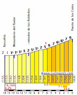
Stage 16: Ordino - Estació d'Esquí Ordino-Arcalis, 17,4km (CRI)


GPM:
Estació d'Esquí Ordino-Arcalis (cat.ESP) 17,4km @ 5,3%
I think it's a pretty well-established fact that, among the mountaintop finishes in the history of cycling, Arcalis is not the most popular with fans. Its meagre average gradient means that although for much of its time in connection with the sport it has been granted Categoría Especial, or Hors Catégorie, this has generally been something of a reach. Nevertheless, since its introduction to the sport in the brutal 1997 Tour stage it has been a regular stop-off for the major races. Of course, its most famous contribution to the sport remains its first, as Jan Ullrich ground everybody into dust in much the same way Indurain had on La Plagne two years earlier, only much more dominantly. It was monstrous power. The climb has since been reused in the Vuelta four times (won by Cardeñas, Jiménez, Mancebo and Menchov) and in the Tour once (2009, won by Brice Feillu, its most recent GT escapade) - although it is of course on the 2016 route. It has also appeared in the Volta a Catalunya in 1998 and then every year from 2004 to 2007, but in the last few years has been out of favour.
A large part of this may be the result of that initial stage and Ullrich's display of strength; the climb has rather developed a negative aura which makes tempo riding favoured and riders are often reluctant to truly attack the climb. This came to a head in 2009 when the terminally dull group ride by the over-strong Astana team was only interrupted late on by Andy Schleck, which gave Contador the excuse to attack a group which was still pretty large in number to gain the time needed to get back ahead of Armstrong on the GC and set into motion the next stage in that rather embarrassing soap opera. Another issue is simply that until now, with the paving of Beixalis, the only way to back Arcalis straight out of another climb was to use the Coll d'Ordino/Collet de Montaup, which is also a tempo climb, and so the diesels were not put on the back foot prior to the final climb; although Beixalis entails a bit more false flat before the final climb it does have the benefit of making the less pure climbers have to do more work to get back before the final climb.
Anyway, the question was therefore, what to do with this climb? My "no repetition" rule does mean that the more Vueltas I do, the fewer my options get, but also you have a venue which seems happy to pay to host races, so we need to find a way to make it work. Andorra also likes its summit finishes, and we've given them a descent finish on Sunday. But before I set to that stage, I was thinking that much like Pal (which is better but still not as good as Arinsal or Els Cortals), Arcalis wants to host races, but how can you ensure a stage where it is GC-relevant on a climb with such an aura of conservative racing without neutralizing the previous parts of the stage? And then it hit me - you'd need a mountain time trial. But then that would give us the freedom to have another Andorra stage that doesn't need to be an MTF. And also, as this is the first stage after the rest day, riders will be fresh for a real show of strength in the mountains.

As you can see, the first few kilometres are just false flat, but then it jumps up to the steepest gradients of the whole stage. However, after 3km at just under 8% it settles down again.

We start in the wonderfully scenic Ordino, the base of the climb, and that gives it part of its name (as opposed to the other related ski stations in the area, which get "Vallnord Sector" as their prefix). The false flat leads us to El Serrat which will be the first time check; at this point, it should still favour those with a more powerful time trial engine; the biggest climbing difference will be between this and the second timecheck which is at the main Arcalis station at 1940m.

There is of course much more climbing yet to do (this is the Cima Alberto Fernández of the Vuelta, topping out at 2236m) as we head to the top station, however the gradients are less steep and more consistent in the final third, which is countered by the twisty corners and constant hairpins.

I know that when I've previously included MTTs in my routes (the Lagos de Covadonga one in my fourth Vuelta, and Planche des Belles Filles in my second Tour) I've been advised that you have to have two roads to do an MTT for logistical purposes, so you can't do them at dead end mountaintops. Personally I disagree. Firstly, places like Kronplatz have resolved this by doing the time trial in waves, allowing the vehicles to get down to the bottom again without the risk of heading directly into riders; secondly, while it may have been easier for organizers to do an MTT on routes with multiple sides (such as Chamrousse, Monte Grappa, Nevegal and Alpe d'Huez in comparatively recent memory) the Vuelta in particular has a history of MTTs on one-sided climbs, such as Valdezcaray in 1991, Monte Naranco on multiple occasions, and this very climb, Andorra-Arcalis, in 2001. It's a special but also sad stage in some ways, for it was the last career triumph of one of the last of the true mythical escaladores, José María Jiménez, who took his second stage win in as many days after winning the Pal MTF solo by a street the previous day. The following year he was gone, retiring due to an ongoing battle with depression; just over a year later he was gone, dying of a heart attack in a psychiatric hospital at the age of 32.

Chava's winning time that day, over the same course as this, was 36'38". It was a nice moment as second place went to that great advert for "riding the climb at your own pace", Chava's brother in law Carlos Sastre. The top 10 was a veritable who's who of Spanish cycling in the era, with Casero, Sevilla, Rubiera and Laiseka also up there, while the most prominent extranjeros were Levi Leipheimer and the following year's Giro KOM Julio Alberto Pérez Cuapio. Roberto Heras could only manage 15th, while the fact David Millar beat Fernando freaking Escartín tells you that this is not a pure climber's ascent in the way some of the steeper or more inconsistent ones are.
A great thing about the Arcalis TT here is that the Volta a Catalunya in subsequent years allows us to monitor climbing times. If we discount the 2004 edition where they only climbed from Llorts, the fact that the Volta had an MTT to Arcalis in 2005 and 2007 on an identical course to this - and to the 2001 Vuelta - enables us to compare directly. Frustratingly, perhaps owing to ITTs being less immediately arresting visual spectacles to a more conventional mountain duel, highlights of these are harder to find (although the 2004 edition is readily available) - however that's why this stage is on a weekday, keeping the queen stage for Sunday! Anyway: 2005's stage was won by Íñigo Cuesta in a time of 37'18", +40" from Jiménez and a time that would have been good for 6th in 2001 (just ahead of Laiseka). Piepoli and Moncoutié were 2nd and 3rd, while in 4th was a surprise, a little-known Kaiku rider who had been toiling in Portugal and was slowly making a name for himself in mountain stages of Spanish domestic races - Ezequiel Mosquera.

2007's winning time was set by the man who won on the same climb in the Vuelta (the race where that unheralded Kaiku rider came to international prominence) later that year, the silent assassin himself Denis Menchov. His time was 38'58", which shows a huge difference from the previous editions. Obviously conditions varied, but had the Pope put in the same ride in the previous chronos, he'd have been 8th in 2005 (there was a huge gap between the top 7, closed off by Mayo, and Eladio Jiménez at +1'46), and a miserable 31st in 2001. Here, however, Denis headed a Russian one-two, as Vladimir Karpets (and his spectacular mullet) took 2nd place which enabled him to secure the race victory as part of that crazy run of form he had where he also won the Tour de Suisse and was top 15 of the Tour and top 10 of the Vuelta. Rémy di Gregorio was 3rd, Vino 4th, Rogers 5th - so really a roll-call of shame considering how far they were from the 2001 times.
Let's see just how much cycling has changed, shall we?

Stage 16: Ordino - Estació d'Esquí Ordino-Arcalis, 17,4km (CRI)
GPM:
Estació d'Esquí Ordino-Arcalis (cat.ESP) 17,4km @ 5,3%
I think it's a pretty well-established fact that, among the mountaintop finishes in the history of cycling, Arcalis is not the most popular with fans. Its meagre average gradient means that although for much of its time in connection with the sport it has been granted Categoría Especial, or Hors Catégorie, this has generally been something of a reach. Nevertheless, since its introduction to the sport in the brutal 1997 Tour stage it has been a regular stop-off for the major races. Of course, its most famous contribution to the sport remains its first, as Jan Ullrich ground everybody into dust in much the same way Indurain had on La Plagne two years earlier, only much more dominantly. It was monstrous power. The climb has since been reused in the Vuelta four times (won by Cardeñas, Jiménez, Mancebo and Menchov) and in the Tour once (2009, won by Brice Feillu, its most recent GT escapade) - although it is of course on the 2016 route. It has also appeared in the Volta a Catalunya in 1998 and then every year from 2004 to 2007, but in the last few years has been out of favour.
A large part of this may be the result of that initial stage and Ullrich's display of strength; the climb has rather developed a negative aura which makes tempo riding favoured and riders are often reluctant to truly attack the climb. This came to a head in 2009 when the terminally dull group ride by the over-strong Astana team was only interrupted late on by Andy Schleck, which gave Contador the excuse to attack a group which was still pretty large in number to gain the time needed to get back ahead of Armstrong on the GC and set into motion the next stage in that rather embarrassing soap opera. Another issue is simply that until now, with the paving of Beixalis, the only way to back Arcalis straight out of another climb was to use the Coll d'Ordino/Collet de Montaup, which is also a tempo climb, and so the diesels were not put on the back foot prior to the final climb; although Beixalis entails a bit more false flat before the final climb it does have the benefit of making the less pure climbers have to do more work to get back before the final climb.
Anyway, the question was therefore, what to do with this climb? My "no repetition" rule does mean that the more Vueltas I do, the fewer my options get, but also you have a venue which seems happy to pay to host races, so we need to find a way to make it work. Andorra also likes its summit finishes, and we've given them a descent finish on Sunday. But before I set to that stage, I was thinking that much like Pal (which is better but still not as good as Arinsal or Els Cortals), Arcalis wants to host races, but how can you ensure a stage where it is GC-relevant on a climb with such an aura of conservative racing without neutralizing the previous parts of the stage? And then it hit me - you'd need a mountain time trial. But then that would give us the freedom to have another Andorra stage that doesn't need to be an MTF. And also, as this is the first stage after the rest day, riders will be fresh for a real show of strength in the mountains.
As you can see, the first few kilometres are just false flat, but then it jumps up to the steepest gradients of the whole stage. However, after 3km at just under 8% it settles down again.
We start in the wonderfully scenic Ordino, the base of the climb, and that gives it part of its name (as opposed to the other related ski stations in the area, which get "Vallnord Sector" as their prefix). The false flat leads us to El Serrat which will be the first time check; at this point, it should still favour those with a more powerful time trial engine; the biggest climbing difference will be between this and the second timecheck which is at the main Arcalis station at 1940m.
There is of course much more climbing yet to do (this is the Cima Alberto Fernández of the Vuelta, topping out at 2236m) as we head to the top station, however the gradients are less steep and more consistent in the final third, which is countered by the twisty corners and constant hairpins.
I know that when I've previously included MTTs in my routes (the Lagos de Covadonga one in my fourth Vuelta, and Planche des Belles Filles in my second Tour) I've been advised that you have to have two roads to do an MTT for logistical purposes, so you can't do them at dead end mountaintops. Personally I disagree. Firstly, places like Kronplatz have resolved this by doing the time trial in waves, allowing the vehicles to get down to the bottom again without the risk of heading directly into riders; secondly, while it may have been easier for organizers to do an MTT on routes with multiple sides (such as Chamrousse, Monte Grappa, Nevegal and Alpe d'Huez in comparatively recent memory) the Vuelta in particular has a history of MTTs on one-sided climbs, such as Valdezcaray in 1991, Monte Naranco on multiple occasions, and this very climb, Andorra-Arcalis, in 2001. It's a special but also sad stage in some ways, for it was the last career triumph of one of the last of the true mythical escaladores, José María Jiménez, who took his second stage win in as many days after winning the Pal MTF solo by a street the previous day. The following year he was gone, retiring due to an ongoing battle with depression; just over a year later he was gone, dying of a heart attack in a psychiatric hospital at the age of 32.
Chava's winning time that day, over the same course as this, was 36'38". It was a nice moment as second place went to that great advert for "riding the climb at your own pace", Chava's brother in law Carlos Sastre. The top 10 was a veritable who's who of Spanish cycling in the era, with Casero, Sevilla, Rubiera and Laiseka also up there, while the most prominent extranjeros were Levi Leipheimer and the following year's Giro KOM Julio Alberto Pérez Cuapio. Roberto Heras could only manage 15th, while the fact David Millar beat Fernando freaking Escartín tells you that this is not a pure climber's ascent in the way some of the steeper or more inconsistent ones are.
A great thing about the Arcalis TT here is that the Volta a Catalunya in subsequent years allows us to monitor climbing times. If we discount the 2004 edition where they only climbed from Llorts, the fact that the Volta had an MTT to Arcalis in 2005 and 2007 on an identical course to this - and to the 2001 Vuelta - enables us to compare directly. Frustratingly, perhaps owing to ITTs being less immediately arresting visual spectacles to a more conventional mountain duel, highlights of these are harder to find (although the 2004 edition is readily available) - however that's why this stage is on a weekday, keeping the queen stage for Sunday! Anyway: 2005's stage was won by Íñigo Cuesta in a time of 37'18", +40" from Jiménez and a time that would have been good for 6th in 2001 (just ahead of Laiseka). Piepoli and Moncoutié were 2nd and 3rd, while in 4th was a surprise, a little-known Kaiku rider who had been toiling in Portugal and was slowly making a name for himself in mountain stages of Spanish domestic races - Ezequiel Mosquera.
2007's winning time was set by the man who won on the same climb in the Vuelta (the race where that unheralded Kaiku rider came to international prominence) later that year, the silent assassin himself Denis Menchov. His time was 38'58", which shows a huge difference from the previous editions. Obviously conditions varied, but had the Pope put in the same ride in the previous chronos, he'd have been 8th in 2005 (there was a huge gap between the top 7, closed off by Mayo, and Eladio Jiménez at +1'46), and a miserable 31st in 2001. Here, however, Denis headed a Russian one-two, as Vladimir Karpets (and his spectacular mullet) took 2nd place which enabled him to secure the race victory as part of that crazy run of form he had where he also won the Tour de Suisse and was top 15 of the Tour and top 10 of the Vuelta. Rémy di Gregorio was 3rd, Vino 4th, Rogers 5th - so really a roll-call of shame considering how far they were from the 2001 times.
Let's see just how much cycling has changed, shall we?
- Aug 3, 2015
- 22,821
- 10,847
- 28,180
I don't know if this is the place to ask, Libertine, but since you are talking about mountain stages in Andorra, what do you make of the stage to Arcalis this year? Surely, it could have been better, but the run-in seems a lot harder than the previous time the climb was used..
- Apr 30, 2011
- 49,042
- 31,681
- 28,180
Re:
...
Personally, I think it'd be at its best if Comella was the last climb, as you then could expect solo moves on Gallina, but I like your stage as it is as well.
Am I mistaken, or isn't Engolasters also usable as a pass?Libertine Seguros said:Stage 15: Tàrrega - Andorra la Vella, 218km
[...]the recent 140km of suffering in the 2015 Vuelta which utilized every mountain pass in the country (much like the Valle d'Aosta, Andorra's one-valley-with-offshoots nature means that the number of passes is limited but there are many summits) including paving a couple anew in order to host.
...
Personally, I think it'd be at its best if Comella was the last climb, as you then could expect solo moves on Gallina, but I like your stage as it is as well.
Re: Re:
Can you design the track on Coronoescalada?Eshnar said:design a short track that includes the climb (and it doesn't finish at the top). Possibly use a fair number of checkpoints on the climb, to make sure the software doesn't **** up. that's pretty much it. The rest is fairly intuitive, you just have to follow the instructions. The map usually behaves funny when you drag the initial and finish point of the climb, but you just need to be careful and double check.SammyLarns said:Hey Eshnar!
Thank you for your help. I was actually hoping to create a few new climbs that aren't already in there. Do you have any tips for this?
VUELTA A NAVARRA STAGE 2: PAMPLONA - OLITE 162km


San Pedro: 5.4km at 7.1%
Uzquita: 4.3km at 55 (Sterrato)
Yes, sterrato! I couldn't help myself. 5 sections, prettily scrappily drawn on (sections 2 and 3 on the profile should be longer and shorter respectively) . More about them later.
The stage starts where yesterday finished. Well not exactly. It starts in Villava, the birthplace of the great Miguel Indurain. Then we go into the centre of Pamplona, then quickly fly to towards the south. Just after the intermediate sprint at Noain, we have our first section of sterrato. It is very short, just 3km long. Shouldn't do much, maybe decide the break if the peloton decide to hold on until the first intermediate sprint for the 3,2,1 bonus seconds.
Our second sterrato section is harder: almost 7km long and includes a 2km uncategorised climb that averages 8%. The descent after is quite tricky and still on sterrato, but is very short. We then dive into a quarry which the road takes us to, I don't know why, still on the sterrato before we leave for a kilometre or two and we approach Sector #3.
Sector #3 is shorter, but the gravel is much less well-kept. It is 3.9km long and includes a gradual climb before the road returns to asphalt for the descent. After 10km of flat our first real climbing diffiulty is revealed.
San Pedro is named as such as the road is called Calle San Pedro so I then named the climb likewise. I do not think this is the real name, but for now it will have to do. It is actually a very difficult climb. The start is pretty shallow, only 5%, but it stiffens up a lot. A kilometre at 8% is followed by one at over 10%, but with steeper pitches. This doesn't contain sterrato until the very top, but it does have Hormigon, a ridiculous invention of actual cement instead of asphalt. The whole of Bola del Mundo is like that. I am not sure why.

After we have a steep descent then a sterrato section on the Uzquita climb, which has a steep first section, a descent, then a steep second section. The sterrato is over 11km long, and is the second longest of today. A long descent takes us to Caseda, our 2nd intermediate sprint. Its a pretty village. A rolling 40km takes us to the decisive sector #6.

Almost 12km long, it starts in the Aragon river valley and heads up towards Ujue. It is mostly flat to start off with, then we head up towards the beautiful hilltop village. The climb is gradual to begin but includes a 2km at 9%. I expect the moves for the stage to be here. The sterrato is not easy and it will make for an very difficult 2km if the pace is high with attacks hopefully coming left, right and centre. WE regain the asphalt just before we reach Ujue, and we have a little excursion through the centre of the pueblito where the pitch actually steepens significantly and the sprint for the final GPM points will take place. Someone might possibly try to drop other companions too. I hope up here for the group to be at least less than 10, hopefully multiple groups of riders strung out. The descent is on the main road and pretty straightforward. After the climb, there is still 17km to reach Olite, of shallow descent and flat at the end. It should be exciting to see everyone trying to catch up. The stage result, should there be many small groups, is completely in the balance. It depends on how the riders work together.

The arrival is in Olite. A very beautiful town, it is larger than Ujue (which isn't hard, to be fair) and home to the Castillo de Olite. It is a peculiar castle as it seems to be built at random. You have four towers in when you feel that you could've done with two just fine. This is because the castle was built sporadically and expanded at different times. It was the seat of Charles III of Navarra (The Noble). The same king who unified the three boroughs of Pamplona, and ended years of feud. History looks upon him mostly kindly. His collection of great-grandchildren includes Henry VII of the Holy Roman Empire; Phillip III of France and Phillip IV of France, to name but a few. The castle was then disused after the invasion of Navarra by the Crown of Castilla y Aragon. In the early 1800s, it was burnt down by a guerrilla force against the forces of Napoleon, who feared that it was a hiding place/safe house. It was then restored, and now you can clearly tell the difference between the old castle and new castle.

The stage finishes in the shadow of this castle. It could be a reduced bunch sprint, or also a group of 5-10, or solo. I have tried to keep it open. Fun fact about Olite: Every August for a week (or weekend, I have forgotten) the town dresses up in medieval costume for a fair. It is also home to many, many different wines and bodegas
San Pedro: 5.4km at 7.1%
Uzquita: 4.3km at 55 (Sterrato)
Yes, sterrato! I couldn't help myself. 5 sections, prettily scrappily drawn on (sections 2 and 3 on the profile should be longer and shorter respectively) . More about them later.
The stage starts where yesterday finished. Well not exactly. It starts in Villava, the birthplace of the great Miguel Indurain. Then we go into the centre of Pamplona, then quickly fly to towards the south. Just after the intermediate sprint at Noain, we have our first section of sterrato. It is very short, just 3km long. Shouldn't do much, maybe decide the break if the peloton decide to hold on until the first intermediate sprint for the 3,2,1 bonus seconds.
Our second sterrato section is harder: almost 7km long and includes a 2km uncategorised climb that averages 8%. The descent after is quite tricky and still on sterrato, but is very short. We then dive into a quarry which the road takes us to, I don't know why, still on the sterrato before we leave for a kilometre or two and we approach Sector #3.
Sector #3 is shorter, but the gravel is much less well-kept. It is 3.9km long and includes a gradual climb before the road returns to asphalt for the descent. After 10km of flat our first real climbing diffiulty is revealed.
San Pedro is named as such as the road is called Calle San Pedro so I then named the climb likewise. I do not think this is the real name, but for now it will have to do. It is actually a very difficult climb. The start is pretty shallow, only 5%, but it stiffens up a lot. A kilometre at 8% is followed by one at over 10%, but with steeper pitches. This doesn't contain sterrato until the very top, but it does have Hormigon, a ridiculous invention of actual cement instead of asphalt. The whole of Bola del Mundo is like that. I am not sure why.
After we have a steep descent then a sterrato section on the Uzquita climb, which has a steep first section, a descent, then a steep second section. The sterrato is over 11km long, and is the second longest of today. A long descent takes us to Caseda, our 2nd intermediate sprint. Its a pretty village. A rolling 40km takes us to the decisive sector #6.
Almost 12km long, it starts in the Aragon river valley and heads up towards Ujue. It is mostly flat to start off with, then we head up towards the beautiful hilltop village. The climb is gradual to begin but includes a 2km at 9%. I expect the moves for the stage to be here. The sterrato is not easy and it will make for an very difficult 2km if the pace is high with attacks hopefully coming left, right and centre. WE regain the asphalt just before we reach Ujue, and we have a little excursion through the centre of the pueblito where the pitch actually steepens significantly and the sprint for the final GPM points will take place. Someone might possibly try to drop other companions too. I hope up here for the group to be at least less than 10, hopefully multiple groups of riders strung out. The descent is on the main road and pretty straightforward. After the climb, there is still 17km to reach Olite, of shallow descent and flat at the end. It should be exciting to see everyone trying to catch up. The stage result, should there be many small groups, is completely in the balance. It depends on how the riders work together.
The arrival is in Olite. A very beautiful town, it is larger than Ujue (which isn't hard, to be fair) and home to the Castillo de Olite. It is a peculiar castle as it seems to be built at random. You have four towers in when you feel that you could've done with two just fine. This is because the castle was built sporadically and expanded at different times. It was the seat of Charles III of Navarra (The Noble). The same king who unified the three boroughs of Pamplona, and ended years of feud. History looks upon him mostly kindly. His collection of great-grandchildren includes Henry VII of the Holy Roman Empire; Phillip III of France and Phillip IV of France, to name but a few. The castle was then disused after the invasion of Navarra by the Crown of Castilla y Aragon. In the early 1800s, it was burnt down by a guerrilla force against the forces of Napoleon, who feared that it was a hiding place/safe house. It was then restored, and now you can clearly tell the difference between the old castle and new castle.
The stage finishes in the shadow of this castle. It could be a reduced bunch sprint, or also a group of 5-10, or solo. I have tried to keep it open. Fun fact about Olite: Every August for a week (or weekend, I have forgotten) the town dresses up in medieval costume for a fair. It is also home to many, many different wines and bodegas
Re:
It was actually imgur, and it's the third time I've done it so badly
You'd think I'd learn.
Red Rick said:Brullnux, I have a sudden and deep respect for you (I'm assuming) microsoft paint skills
It was actually imgur, and it's the third time I've done it so badly
You'd think I'd learn.
- Mar 24, 2011
- 10,527
- 1,927
- 25,680
Re: Re:
of course. You have to save it there.Brullnux said:Can you design the track on Coronoescalada?Eshnar said:design a short track that includes the climb (and it doesn't finish at the top). Possibly use a fair number of checkpoints on the climb, to make sure the software doesn't **** up. that's pretty much it. The rest is fairly intuitive, you just have to follow the instructions. The map usually behaves funny when you drag the initial and finish point of the climb, but you just need to be careful and double check.SammyLarns said:Hey Eshnar!
Thank you for your help. I was actually hoping to create a few new climbs that aren't already in there. Do you have any tips for this?
- Feb 18, 2015
- 13,911
- 10,038
- 28,180
Am I the only one who is too stupid to make a climb profile? I just don't get it. Whatever
Österreich Rundfahrt stage 3: Innsbruck - Saalfelden (162 km)


After very hard first two stages this is the first chance for the sprinters.
We start in Innsbruck where yesterdays stage finished, but instead of using one of the many hills in that area the race goes straight through the valley "Inntal" mostly like in this stage from last years Österreich Rundfahrt which finished in Innsbruck. On the way to the first climb the route passes many towns like Schwaz and Wörgl right before the end of the flat, where also an intermediate sprint will take place.
The mentioned first climb is Wildschönau and although the climb isnt even 5% steep I still rated it 3rd category because its pretty long. Yeah, I know 4th category would probably be the better categorization but as I wrote it earlier I tend to overcategorize most ascents in this race. Btw, this is also a situation in which it would be great if I would understand how to make profiles of climbs on cronoescelada .

After the a little bit steeper descent and about 20 more flat kilometers the riders ride trough Kitzbühel where another intermediate sprint takes place and directly afterwards the riders start the climb to the Kitzbüheler Horn...oh wait, no they don't. Directly afterwards the riders start the climb to the Kitzbüheler Horn in every boring Österreich Rundfahrt of the last decade but this time they instead climb the easy Pass Thurn. This climb is even flatter than Wildschönau but also a bit longer and while Wildschönau is a rather unknowns ascent the Pass Thurn is a pass which has been used quite often in cycling races.

The fact that this was already the last climb of the whole stage already shows, this one will be for the sprinters. And really, after the descent the remaining 40 kilometers are pan flat. The riders will still ride through the towns Mittersill and especially the incredibly scenic city Zell am See.

And only 14 more kilometers later the stage ends in Saalfelden.

As I said earlier, this is a very flat and easy stage for the sprinters but I just can't make a mountain stage every day. Especially after the two last stages and the very hard stage 4 which I will post tomorrow I think its not a bad idea to let the riders rest a bit and the finishing area today already indicates how much brutal stuff I can do in stage 4.
Österreich Rundfahrt stage 3: Innsbruck - Saalfelden (162 km)
After very hard first two stages this is the first chance for the sprinters.
We start in Innsbruck where yesterdays stage finished, but instead of using one of the many hills in that area the race goes straight through the valley "Inntal" mostly like in this stage from last years Österreich Rundfahrt which finished in Innsbruck. On the way to the first climb the route passes many towns like Schwaz and Wörgl right before the end of the flat, where also an intermediate sprint will take place.
The mentioned first climb is Wildschönau and although the climb isnt even 5% steep I still rated it 3rd category because its pretty long. Yeah, I know 4th category would probably be the better categorization but as I wrote it earlier I tend to overcategorize most ascents in this race. Btw, this is also a situation in which it would be great if I would understand how to make profiles of climbs on cronoescelada
.
After the a little bit steeper descent and about 20 more flat kilometers the riders ride trough Kitzbühel where another intermediate sprint takes place and directly afterwards the riders start the climb to the Kitzbüheler Horn...oh wait, no they don't. Directly afterwards the riders start the climb to the Kitzbüheler Horn in every boring Österreich Rundfahrt of the last decade but this time they instead climb the easy Pass Thurn. This climb is even flatter than Wildschönau but also a bit longer and while Wildschönau is a rather unknowns ascent the Pass Thurn is a pass which has been used quite often in cycling races.
The fact that this was already the last climb of the whole stage already shows, this one will be for the sprinters. And really, after the descent the remaining 40 kilometers are pan flat. The riders will still ride through the towns Mittersill and especially the incredibly scenic city Zell am See.
And only 14 more kilometers later the stage ends in Saalfelden.
As I said earlier, this is a very flat and easy stage for the sprinters but I just can't make a mountain stage every day. Especially after the two last stages and the very hard stage 4 which I will post tomorrow I think its not a bad idea to let the riders rest a bit and the finishing area today already indicates how much brutal stuff I can do in stage 4.
- Feb 20, 2010
- 33,229
- 15,743
- 28,180
Netserk - Engolasters is the same from both sides after La Comella so I think no, not ridable from more than one side at least.
Valv.Piti - the stage is ok, but I would really rather have seen La Rabassa or La Gallina in the run-in (even instead of La Comella if there was too much concern about length) to bring some of the tougher climbs closer to the finish; as it is Bonaigua and Cantò will get soft-pedalled by anybody important, and it will all be about hoping that Beixalis puts enough domestiques out to make Arcalis less of a tempo climb.
Gigs_98 - you can't do much more than that with Mont Carò, and as the Saturday before a brutal Sunday stage the riders would have soft pedalled until the MTF anyway; the climb is hard enough to make a difference on its own. Arcalis, well, that's partly as this is supposed to be a more "human" Vuelta, with longer climbs but fewer murder gradients (though not as gradual as 2003 with Envalira and Cam Basque), and while I'd rather use some other Andorra summits, Arcalis is a historic climb that likes to host cycling and as this is my 7th Vuelta route it made sense that they would want to include it somewhere along the line - and this is absolutely the only way to guarantee time gaps on a climb that has such an aura.
- Feb 18, 2015
- 13,911
- 10,038
- 28,180
@Libertine: I was being sarcastic, I think you made clear in your posts why the use of these climbs made perfect sense in this situations.
Österreich Rundfahrt stage 4: Bischofshofen - Kleefeld (207 km)


As I have already written yesterday, stage 3 will only be the calm before the storm on stage 4. This is probably the hardest stage of the race and the last real mountain stage of my Österreich Rundfahrt. To be honest it is quite unconventional since the complete middle section of the stage is in Germany and not in Austria, because there are sometimes long pauses between two climbs and because some of the climbs are rather unknown but I will try to explain everything later
The start of the stage is in Bischofshofen, a town mainly known for the "Paul Außerleitner Schanze" a famous skimping hill which is used every year as the last station of the Vierschanzentournee, one of the most important ski jumping competitions.

Directly after the start the riders already have to tackle the first climb of the day, and its not an easy one. The Dientner Sattel doesnt look extremely difficult at the first sight but if you look at the profile you see that only the first half of the ascent is flattish while the second one is extremely steep. Yes these are 3 kilometers of over 11% with sections of 14%, this is absolutely brutal and although it comes early in the stage it will at least ensure a very strong break.

After the top there is only a very short descent followed by another bump, the Filzensattel.
After this climb however the route is getting a bit easier. The riders pass the famous skiing areas Maria Alm and Lofer and then drive over the border into Germany. First of all, I have to admit that the combination of the next four climbs is absolutely nothing new and almost always used when anyone on this forum makes a stage race in Germany. That normally has the simple reason that you wont find any more difficult climbs in this country than here, but in my case the reason a little bit different. When I designed this race there were some climbs which I somehow wanted to use like the Piller Höhe in stage 1, the Gramartboden in stage 2 and in this stage the Lienbachsattel (the penultimate climb), simply because these are climbs which are in my opinion not as famous as they should be considering their difficutly. However its hard to find a good approach to some of these ascents and especially in this case there just are not super difficult passes near the Lienbachsattel so I decided to make the race as hard as possible earlier on by going through Germany.
So the first two climbs are the Schwarzbachsattel and the Hochschwarzeck, two 3rd category climbs.

However the next climb is already a more difficult one, the brutal Dürreckstraße. But hey, this climb is even shorter than the two previous ones, so what could that possibly mean? Well it could mean that its two times steeper and that its average elevation gain is about as high as the maximum gradients of most climbs in the world. Seriously, 12% are just brutal and will not only hurt many riders but also ensure that the teams wont be extremely big and still completely fresh at the end of the race.

And the brutal stuff in Germany isnt even over because there is still another 1st category climb left, the flatter but a bit longer Roßfeld Höhenringstraße. I decided to not go the whole way down to Berchtesgaden and then climb the whole pass. That would have made the stage even harder but its just kind of against my goal to make an Österreich Rundfahrt without stages which have one super hard climb and a few easier ones. Moreover only the second half of this climb is already hard enough for a ET race.

After this climb the rider have a long descent back to Austria and to an intermediate sprint in Hallein. But only because they are in Austria again it doesnt mean that the riders can stop climbing because the next climb, the Wegscheid, follows directly. However this ascent isnt as brutal as the two previous ones, but considering how hard the last 60 kilometers have been the climb will hurt anyway and will make it even harder for teams to control the race.

Now however the race really gets a bit easier at least for the next 15 kilometers, because then the riders tackle the last very hard climb of the day, the Lienbachsattel. This pass neither has the monster gradients the Dürreckstraße had, nor the length of many alps climbs, but its still steep enough to cause some serious attacks and long enough that you can win the tour here. And especially after this already hard stage and the rather weak field because its only an European Tour race this climb should be very interesting. It is a very irregular ascent even with a short descent near the top and although the steepest kilometers are "only" 9% steep there are stretches of up to 13%.
As I have written earlier this pass is very unknown which is just a pity. Of course this isnt as hard as the Großglockner, the Zillertaler Höhenstraße or many other famous climbs in Austria but its still a very difficult 1st category climb, which unforunately is located more northern than all the other big passes of the country so you easily forget about it if you think about great climbs in Austria. Still I think it deserves some more attention so I wanted to include it in my route.

But the race isnt finished after this climb because there is still one more climb to go, the short but steep ramp up to Kleefeld where the stage will finish. This wont cause any huge time gaps but if riders are still together after the Lienbachsattel they get a chance to still gain a little bit of time on this last ascending kilometer.

Österreich Rundfahrt stage 4: Bischofshofen - Kleefeld (207 km)
As I have already written yesterday, stage 3 will only be the calm before the storm on stage 4. This is probably the hardest stage of the race and the last real mountain stage of my Österreich Rundfahrt. To be honest it is quite unconventional since the complete middle section of the stage is in Germany and not in Austria, because there are sometimes long pauses between two climbs and because some of the climbs are rather unknown but I will try to explain everything later
The start of the stage is in Bischofshofen, a town mainly known for the "Paul Außerleitner Schanze" a famous skimping hill which is used every year as the last station of the Vierschanzentournee, one of the most important ski jumping competitions.
Directly after the start the riders already have to tackle the first climb of the day, and its not an easy one. The Dientner Sattel doesnt look extremely difficult at the first sight but if you look at the profile you see that only the first half of the ascent is flattish while the second one is extremely steep. Yes these are 3 kilometers of over 11% with sections of 14%, this is absolutely brutal and although it comes early in the stage it will at least ensure a very strong break.
After the top there is only a very short descent followed by another bump, the Filzensattel.
After this climb however the route is getting a bit easier. The riders pass the famous skiing areas Maria Alm and Lofer and then drive over the border into Germany. First of all, I have to admit that the combination of the next four climbs is absolutely nothing new and almost always used when anyone on this forum makes a stage race in Germany. That normally has the simple reason that you wont find any more difficult climbs in this country than here, but in my case the reason a little bit different. When I designed this race there were some climbs which I somehow wanted to use like the Piller Höhe in stage 1, the Gramartboden in stage 2 and in this stage the Lienbachsattel (the penultimate climb), simply because these are climbs which are in my opinion not as famous as they should be considering their difficutly. However its hard to find a good approach to some of these ascents and especially in this case there just are not super difficult passes near the Lienbachsattel so I decided to make the race as hard as possible earlier on by going through Germany.
So the first two climbs are the Schwarzbachsattel and the Hochschwarzeck, two 3rd category climbs.
However the next climb is already a more difficult one, the brutal Dürreckstraße. But hey, this climb is even shorter than the two previous ones, so what could that possibly mean? Well it could mean that its two times steeper and that its average elevation gain is about as high as the maximum gradients of most climbs in the world. Seriously, 12% are just brutal and will not only hurt many riders but also ensure that the teams wont be extremely big and still completely fresh at the end of the race.
And the brutal stuff in Germany isnt even over because there is still another 1st category climb left, the flatter but a bit longer Roßfeld Höhenringstraße. I decided to not go the whole way down to Berchtesgaden and then climb the whole pass. That would have made the stage even harder but its just kind of against my goal to make an Österreich Rundfahrt without stages which have one super hard climb and a few easier ones. Moreover only the second half of this climb is already hard enough for a ET race.
After this climb the rider have a long descent back to Austria and to an intermediate sprint in Hallein. But only because they are in Austria again it doesnt mean that the riders can stop climbing because the next climb, the Wegscheid, follows directly. However this ascent isnt as brutal as the two previous ones, but considering how hard the last 60 kilometers have been the climb will hurt anyway and will make it even harder for teams to control the race.
Now however the race really gets a bit easier at least for the next 15 kilometers, because then the riders tackle the last very hard climb of the day, the Lienbachsattel. This pass neither has the monster gradients the Dürreckstraße had, nor the length of many alps climbs, but its still steep enough to cause some serious attacks and long enough that you can win the tour here. And especially after this already hard stage and the rather weak field because its only an European Tour race this climb should be very interesting. It is a very irregular ascent even with a short descent near the top and although the steepest kilometers are "only" 9% steep there are stretches of up to 13%.
As I have written earlier this pass is very unknown which is just a pity. Of course this isnt as hard as the Großglockner, the Zillertaler Höhenstraße or many other famous climbs in Austria but its still a very difficult 1st category climb, which unforunately is located more northern than all the other big passes of the country so you easily forget about it if you think about great climbs in Austria. Still I think it deserves some more attention so I wanted to include it in my route.
But the race isnt finished after this climb because there is still one more climb to go, the short but steep ramp up to Kleefeld where the stage will finish. This wont cause any huge time gaps but if riders are still together after the Lienbachsattel they get a chance to still gain a little bit of time on this last ascending kilometer.
- Feb 20, 2010
- 33,229
- 15,743
- 28,180
I did want to justify Arcalis since it's a climb I hate though also, planning out the Andorra stages gave me the chance to watch Chava in full flight again, which is always a pleasure.
It's really a shame that the Österreichrundfahrt's format is so cast-iron because there are so many areas with undiscovered climbs in the country (that Discovering Austria thread I started before the forum decided it couldn't cope with diacritics temporarily and it got abandoned could have swelled to a length beyond the 21 HCs the Tour should use and 21 ESPs the Vuelta should use threads - although I could readily have made an extended version of that thread had I elected to use Canarias climbs or others that are within the realms of the Vuelta but not in Spain (e.g. Alto da Torre, Pierre-Saint-Martin although that is now being used of course, Errozate which Unipublic might try even if ASO wouldn't), climbs being used by other races but not the Vuelta whether in Spain or not (e.g. Port-Ainé) and borderline cases (e.g. Alto de La Bobia, Santuário del Acebo) and climbs which have since been used (e.g. Coll de la Gallina, Ermita de Alba). There's just so much still to choose from in Austria that they could have one of the most varied routes out there and frankly I don't think the race is too hard at all, it just paces where it puts climbs badly so that stages can be super hard without being selective (albeit nothing like as bad as the appalling Big Bear stages in California).
also, planning out the Andorra stages gave me the chance to watch Chava in full flight again, which is always a pleasure.It's really a shame that the Österreichrundfahrt's format is so cast-iron because there are so many areas with undiscovered climbs in the country (that Discovering Austria thread I started before the forum decided it couldn't cope with diacritics temporarily and it got abandoned could have swelled to a length beyond the 21 HCs the Tour should use and 21 ESPs the Vuelta should use threads - although I could readily have made an extended version of that thread had I elected to use Canarias climbs or others that are within the realms of the Vuelta but not in Spain (e.g. Alto da Torre, Pierre-Saint-Martin although that is now being used of course, Errozate which Unipublic might try even if ASO wouldn't), climbs being used by other races but not the Vuelta whether in Spain or not (e.g. Port-Ainé) and borderline cases (e.g. Alto de La Bobia, Santuário del Acebo) and climbs which have since been used (e.g. Coll de la Gallina, Ermita de Alba). There's just so much still to choose from in Austria that they could have one of the most varied routes out there and frankly I don't think the race is too hard at all, it just paces where it puts climbs badly so that stages can be super hard without being selective (albeit nothing like as bad as the appalling Big Bear stages in California).
TRENDING THREADS
-
 Paris-Roubaix 2026, one day monument, April 12
- Started by Lequack
- Replies: 2K
-
 Itzulia Basque Country 2026, April 6-11
- Started by Dazed and Confused
- Replies: 2K
-
 Ronde van Vlaanderen 2026, monument, April 5 (men's)
- Started by Krzysztof_O
- Replies: 1K
-

-
 Teams & Riders The Remco Evenepoel is the next Eddy Merckx thread
- Started by DNP-Old
- Replies: 39K
-
 Teams & Riders Tadej Pogačar discussion thread
- Started by Lequack
- Replies: 43K
-


Cyclingnews is part of Future plc, an international media group and leading digital publisher. Visit our corporate site.
© Future Publishing Limited Quay House, The Ambury, Bath BA1 1UA. All rights reserved. England and Wales company registration number 2008885.