This one is risky. I'm not sure if it's good enough to be a separate thread if it doesn't belong to Great "unknown" climbs thread. Propably this thread will land in a trash bin soon. I've decided to do it separately so this post won't be lost in Race Design Thread (where imo it belongs). While the layout of this post might be similar to 21 HC climbs the Tour should (re)visit thread it definitely doesn't belong there.
Playing in France (and partly in Bolzano province in Tyrol) resulted in a lot of places that propably are good enough to host a WT stage while being neglected by WT and Race Design Thread. Some of them could even try for a GT appearance. For now i've chosen 9 french mtf's and one italian which i didn't saw used or mentioned either in real life or in this forum. Because i'm tackling their usability i will be more concerned about location, road access and amount of available space rather than history, graphics or other more or less related to cycling topics.
The point of this thread is to give designers some tools to work in a particular area so they won't lose time for research and just go to the stage.
1. La Clusaz-Crêt du Merle 1497m.
This ski lift up to Aiguille de Borderan (2492m) belongs to wide La Clusaz ski area which is located between La Grande Balmaz (2616m) – a mountain in Aravis massif, Col de la Colombière (Le Grand-Bornard) and Col de la Croix Fry (Manigod). Sometimes Dauphine or Tour de France finish in the area, mostly in Le Grand-Bornard. Last time it happened in Tour de France 2013 stage 19.
Normally such ski lifts (basically 2 or 3 buildings) don't have any chances to host any stage in real life but this one is a part of La Clusaz. It has a rather sizeable parking space (one of the biggest in La Clusaz) and i guess La Clusaz would be more interested to have a finish in the town rather than Le Grand-Bornard. I doubt Tour de France will manage to have a finish there but Dauphine may try it someday.
The parking space isn't wide (5 to 6m) but is roughly 200m long. Road up there is 1,2 to 1,5-lane wide on a mediocre surface (asphalt seems to have small cracks) and goes through 9 serpentines. Those are not Tour de France standards but Dauphine may be fine enough. If not then definitely Tour l'Avenir will manage a finish there.

Road up to Crêt du Merle.
As a climb Crêt du Merle is 3,5km at 10,5% which makes a borderline 2/1 cat. It's short, very steep (10% avg is very high) and is rather regular. Location of this climb is very good with Col de la Colombière, Col de la Croix Fry and Col des Aravis nearby. It can be used as a nice change to Toue de France 2013 stage 19, after Aravis and Saisies/Bisanne or Romme/Colombière. It can be used as an opening MTT too.

Climb to Crêt du Merle.
When i was making this description i found that it was at least once used in Velowire forum. It was in a Tour de France by user bapt77, it was stage 19 from Chambery to La Clusaz (Crêt du Merle) and it went through Tamié, Epine and Croix Fry before Crêt du Merle.
2. Chinaillon-Le Grand-Bornand 1250m.
I will stay in La Clusaz for a while. This time it is much more known Le Grand-Bornand, but with a different finish. The village of Chinaillon is half-way through Col de la Colombière. The road i'm interested in is Route de l'Envers. It's on the other side of Le Chinaillon river. This road is 2km long and there are parking lots almost everywhere. The biggest one is half-way down the road nearby Le Grand Bornand ski school (ESF Grand Bornand) when you can learn skiing and snowboarding. I'm not sure if this or any adjacent facilities in Chinaillon would be interested in having a cycling race finish (a ski school is rather unorthodox place to have a finish) but there is plenty of space for such.
Parking lot near ESF Grand Bornand is quite sizeable. It's 150m long and max 20m wide
(close to 3km^2 which is good enough for Tour de France). There are two slightly smaller ones before and a couple after ESF Grand Bornand which end when Route de l'Envers joins D4 Col de la Colombière road. The road up is around 1,5-lane wide but in a rather poor condition. The amount of available space is good enough to maybe even host Tour de France, maybe after a potential road modernization.

Parking lot near ESF Grand Bornand, Chinaillon.
From Le Grand-Bornand to ESF Grand Bornand it's 6,7km at 4,9% which makes a borderline 3/2 cat.

Profile of Col de la Colombière from Le Grand-Bornand. The climb to Chinaillon is from km 12 to km 5.
It can be used as a mtf from Le Grand-Bornand or a descent from Col de la Colombière. If i remember finishes in 2009 and 2013 were in the town on Route de la Patinoire so this would make an unused version of Le Grand-Bornand finish. Like it was with Crêt du Merle it can be linked with Aravis – Saisies/Bisanne, Tamié – Epine – Croix Fry or as a descent finish from Col de la Colombière.

Possible finish in Chinaillon.
I doubt this place is a propable candidate for future Dauphine or Tour de France finish as there's one established finish place in Le Grand-Bornand. Thankfully the area is interested in cycling so maybe one day some race will decide to change a lil bit and use this place.
3. Manigod l'Etale 1575m & Col de Merdassier 1500m.
Last place from La Clusaz ski area. This one looks like a rather fancy small ski station with plenty of space available but not the best of road conditions. It's connected with Col de la Croix Fry west, l'Etale (2483m) and Pointe de Merdassier (2313m) summits east. It looks like Manigod would handle the finances itself but if not then there's allways La Clusaz.

Manigod l'Etale ski station.
On top of Col de la Croix Fry is a wide, 2-lane D160 road which goes right from the main road down to La Clusaz. This road is 2,5km long and is on a plateau. After reaching Col de Merdassier it narrows a bit to roughly 1,5-lane and the surface worsens up a bit. From there up to the ski station is 1,4km. Last 1,2km goes uphill at 8%.

Climb to Manigod l'Etale.
There's plenty of space to have a finish either in the station itself or on Col de Merdassier. On Col de Merdassier it's 60m x 50m parking lot which should be enough for Dauphine or even Tour de France. If it comes to the ski station it has a couple of those. Two of them, the bigger ones are at the entrance as they could be used to carry buses and other bigger vehicles while in the station itself would be only most imporant cars and finish installations. Sadly there's no streetview so i will go with a satelite image which is in a quite good quality.

Satelite image of Manigod l'Etale.
This ascent is an extention of Col de la Croix Fry. It's 3,9km long and most of it is on a false-flat. Only last 1,2km are at 8% which makes a borderline 3/4 cat. I'm not sure if this ascent should be counted with Col de la Croix Fry or not.
I'm not sure if this fancy little ski station is interested in having a cycling race. La Clusaz ski area has an established finish place in Le Grand-Bornand so it can be a bit problematic. Still i think a Dauphine and even a Tour de France wouldn't have any logistical problems with an eventual finish here. I think it's the second propable finish place in La Clusaz ski area outside Le Grand-Bornand which might be seen someday in real life. First one is Crêt du Merle which has Dauphine written all over the place while the last one is Chinaillon because Le Grand-Bornand has it's established finish place.
4. Station La Sambuy 1145m.
First mtf outside La Clusaz ski area but still close to it. It's located on the eastern edge of Bauges massif just a couple of kms north of Col de Tamié, on the slopes of La Sambuy summit (2198m). It's hardly a ski station as there isn't even a hotel, but there are at least 10 ski slopes and some sledge tracks. It belongs to the small town of Seythenex close to Faverges. I doubt both of those towns are capable of holding a WT race finish. Maybe Albertville could decide to help as it's quite close to it but i think Albertville would be more interested in a finish in the city rather than on an obscure ski station.

Climb to Station La Sambuy.
There's a lot of space available on the station – roughly 4km^2 which is enough for even a Tour de France but the problem is that for some reason only half of this space is asphalted, other half is gravel. It could be resurfaced if an eventual finish would be held there. I couldn't find in what condition the road up to the station is.

Parking on Station La Sambuy.
Now to the climb itself. It depends from where you want to start as the climb theoretically begins in Faverges. Counting from there it's 10,4km at 6%. Most of the part from Faverges is false flat so counting from Seythenex, where the actual climb starts is 5,4km at 7,6% (max 11%) which makes it a strong 2 cat.

Profile of Station La Sambuy.
Probability of hosting a WT race? Rather slim. There is no logistic problem whatsoever but the station is small and the proximity with Albertville doesn't help either. I doubt there will be enough money rised to host a finish there ever.
5. Arêches-Beaufort 1020m/1032m & Le Planey-Beaufort 1200m.
This one is hardly a mtf but straight from Beufort it is an uphill finish nonetheless. Arêches is a village south of Beufort. It should be known in the race design community as it's the entrance to Col du Pré and Cormet d'Arêches. Arêches is a part of Beufort and is the main facility of Beaufortain ski area so there shouldn't be any big money problems. If i remember correctly Beaufort itself sometimes hosted Dauphine stages not long time ago while having only small amount of available space. Sadly nowadays WT races doesn't seem to be interested in finishes in Beufortain massif.

Arêches at night.
In Arêches there's a parking lot (bus station?) southwest of the village on D218A. It's split by two thanks to Ruisseau de l'Argentine creek. Overally it's around 5km^2 of available space so it's perfectly enough for even a Tour de France. Problem lies in the unfortunate location on the southwest tip of the village, basically in the middle of nowhere. It can be used to carry buses and other cars while the finish line could be in the village like on Place Capitaine Bulle.

Possible finish location in Arêches.
As a climb it works only straight from Beaufort. From there to Place Capitaine Bulle is 5km at 5,7% which makes a strong 3 cat.

Profile of Col du Pré from Beaufort. First 5km is the climb to Arêches.
Road up to the village is mostly two-lane on a good surface. Only last roughly 500m are slightly narrower. There are however two other sides that could be used, but aren't very realistic. One side is from Col du Pré but the descent would be highly dangerous while the road is very narrow and unsecured. Other side is from Plan du Chuet which i once used in an unreleased Tour l'Avenir but sadly the road up and down is of similar quality as the Col du Pré one. Thankfully it can be perfectly linked with Roselend, Saisies or Bisanne.

Climb to Arêches.
Actually there is no need to end in the village as there is some space available in a nearby village of Le Planey outside of Chalet La Roche Novie. Then the climb would be 8,3km at 5,5% which makes it a cat. 2. Le Planey is a small village/ski resort which propably will never see any major cycling action because of it's size.
Probability of hosting a WT race? Doubtful. Dauphine and Tour de France doesn't seem to be interested in Beaufortain. They use it mostly as a transit to other regions in Alpes. But thanks to the discovery of Bisanne they might look at better possibilities than Bettex, but riders needs to help in making the decisions. Like the atomic 2011 stage to l'Alpe caused a storm of copycat stages in next couple of years a good ride on Bisanne might cause it to be the next big thing. Hoping for a stage like Giro's Paganella one. Sadly or not there is a bigger station in Beaufortain that is much more capable of hosting a WT stage.
6. Col des Saisies 1650m.
I really don't think this pass needs any further introduction but it's often forgotten that it's a quite big ski station too. I'm not sure, propably Libertine will know that much better, but wasn't the station on top of Saisies a biathlon centre in Albertville olimpics? There's more than enough space to host a Tour de France finish either on the northern tip of the station on top of Col des Saisies or on the southern tip en route to Bisanne. I don't think i need to expand further on this as you can just check out satelites and streetview.
This one is the most propable to host a stage in either Dauphine or Tour de France. The propability lies in how this year's Bisanne stage will be ridden. If Bisanne will be the next fashion, next big thing then ASO will definitely want to have it as a mtf because ASO. While i propably would prefer an Aprica type of finish in Arêches, mtf on top of Col des Saisies is the most propable option.
In Beaufortain there are at least one or two possibilities, but they're rather unrealistic for a WT race. One of them is straight from PCM – Notre-Dame-de-Bellecombe. It's on the ascent to Saisies via Flumet. In the village there is some small amount of available space but it's a very small one. Maybe l'Avenir or a smaller alpine race could have a finish there.

Possible finish place in Notre-Dame-de-Bellecombe.
Similar or maybe a bit bigger available space is in the adjacent village of Crest-Voland. Sadly it's mostly neglected by real life and not often seen in Race Design Thread. It's the Crest-Voland side of Saisies that is the hardest one outside Bisanne. For a long time i had it in my Tour de France before i changed the route completly (for the n-th time).
7. Puy-Saint-Vincent 1800 1780m.
Heading down south i found a rather obscure ski station in Val Durance, couple of kms south of Briançon. Or i thought it was obscure as it even landed an article in The Guardian. It did a fine job in describing the station so i will limit myself to the logistics.

Puy-Saint-Vincent.
This station is a carbon copy of a typical alpine station. It has three elevations: 1400, 1600 and 1800m. Each one of them has it's own available space to work with. Interestingly because the road through the station is a serpentine one there is no space to have finish installations because of elevation changes on the sideroad. Actually it might force to have a finish in one of the parking lots. The highest one is on the 1800 elevation and i will place the finish line there. As you can see below these parking lots aren't biggest one in the world but their amount should compansate enough for a Dauphine type of race.

Climb to Puy-Saint-Vincent 1800.

Possible finish in Puy-Saint-Vincent 1800.
As a climb Puy-Saint-Vincent 1800 is medium-sized, regular, rather typical 1/2 cat. There are two sides possible. First one – the main one is from Vallouise and it's 8km at 7,3% (max 9%) which makes it an easy 1 cat. This side is on a quite wide road – 1,5 to 2-lane on an acceptable surface.

Puy-Saint-Vincent 1800 from Vallouise.
Second side – from Les Vigneaux is longer, more complicated and irregular. It's 11km at 6,4% which makes it a 1 cat. This ascent is of similar difficulty as the first one but this one is more irregular. First 3kms are quite tough maxing at over 9% before next 2km of false-flat. Then, in Puy-Saint-Vincent 1400, the road joins the regular one from the first ascent. The road up to Puy-Saint-Vincent 1400 is slightly narrower than on the first variant. It's roughly 1,2-lane wide on an acceptable surface.

Puy-Saint-Vincent 1800 from Les Vigneaux.
The biggest problem this mtf has is it's rather poor placement. Being located in the middle of Val Durance ensure that there are no nearby climb available. The closest one is propably Col d'Izoard. There is however a col just southeast of Puy-Saint-Vincent – Col de la Pousterle but it's a sterrato road. Looks like it's in a fine condition but it's not Finestre and ASO will never decide to use it. Interestingly i once seen a stage going like that in Velowire forum i think.
Probability of hosting a WT race? I think nonexistent. It's a worser l'Alpe d'Huez and Risoul is allready and established mtf in ASO eyes. Besides Risoul is much better placed, it's closer to either Agnel, Izoard or Vars than Puy-Saint-Vincent. Basically Puy-Saint-Vincent is a ___/ type of mtf. But if someone wants to shake a bit it's Tour or Dauphine he might use this mtf rather than Risoul.
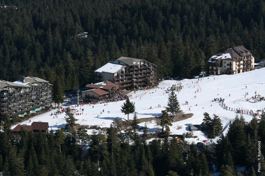
8. Enchastrayes-Le Super-Sauze 1705m.
The hidden brother of Pra-Loup. It's a rather unknown ski station just south of Barcelonnette. It belongs to the village of Enchastrayes. In architecture it looks like a smaller version of Pra-Loup.

Super Sauze.
Road up to the station is around 1,5-lane wide on mediocre surface. It's very twisty with close to 20 turns and serpentines in the last 7km. Like Pra-Loup it has a lot of bigger and smaller roadside parking space so a Dauphine or even Tour de France shouldn't be a big problem there. The biggest problem is with it's location. It's not only close to Pra-Loup which is a much bigger and prestigious station but it lies in the middle of Val d'Ubaye so linking with Cayolle and Allos is worser but it's a bit better with Bonette, Vars and Maddalena.

Climb to Super Sauze.
Super Sauze is a bit easier than it's bigger brother. It's 9km at 6,2% which makes a borderline 1/2 cat. But cutting first and last km of flase flat this ascent is 7km at regular 7,3% (max 10%). It's not the hardest of climbs and it's brother Pra-Loup is slightly harder but very twisty road can spike up the difficulty a bit making it like an irregular ascent.

Profile of Super Sauze.
Probability of hosting a WT race? Is this climb better than Pra-Loup? I dont think there's any need to change an established mtf. But in design community this climb can be a fine refreshment of an often used formula. Bonette, Cayolle and Allos will never be overused but once in a while Super Sauze might be a nice change between Pra-Loup, Jausiers or Auron.
9. Peyragudes-Les Agudes 1570m.
Yet another forgotten brother of a more popular station. When in 2012 Tour de France was going to finish on Peyragudes i was thinking of Les Agudes rather than Les Balestas. For a long time i thought this was the next example of a collapsing Pyreneean ski station like those in Atlantiques but it looks like it's still operating. It belongs to the Peyragudes ski area so it should be not only operative but interested in cycling. While Les Balestas is ideal if a stage goes from east Les Agudes is a much more interesting choice if a stage goes from west.

Les Agudes ski station.
The road up to Les Agudes is roughly 5km off the top of Col de Peyresourde. From Bagnères-de-Luchon it's 15,3km at 6,2%, cat. 1. It's slightly longer but easier than Peyresourde. Most of the climb however is shared with the Peyresourde ascent so the distinct bit is only 6km at 6,4% which is a 2 cat.

Profile of Les Agudes.
The road up to the station (D76B) is a quite typicall for a french road. It switches between 2-lane and roughly 1,5-lane without any sense. Most of the road is in a fine surface but the last 3 to 4km are quite rough. In the station itself there's quite a lot of available space (around 2km^2) so a Route du Sud can use it as a mtf. If it's big enough for a Tour de France? Propably yes, as there are some other smaller parking lots down the climb.

Climb of Les Agudes.
Probability of hosting a WT race? I hope high. The dream scenario would be to use Balestas from east and Les Agudes from west. I actually plan to use this climb in my Tour de France. Stage would go from either Pau or Tarbes via Tourmalet, Aspin or Ancizan, Azet and Peyresourde. I remember i've seen it at least once mentioned in Velowire forum around 2014.

Old version of my planned stage to Les Agudes. Back then didn't considered descent from Ancizan to be safe enough for rather conservative ASO.
10. San Martino/Reinswald 1570m.
The only one for now that is in Italy. It's a quite sizeable village and ski station located at the end of Val Sarentino north of Bolzano, on the western slope of Cima San Cassiano (2581m). Sometimes an European Cup pays a visit to have a downhill competition – a very obscure information which i cannot validate. The only winter sport i have some slightly deeper knowledge is Ski Jumping. It will be mentioned in my upcoming Giro del Trentino.

San Martino.
Logistically there's quite a lot of space in San Martino (parking in the ski station) and the road up to the ski station is in good condition, around 1,5-lane width. A very narrow asphalted road goes much higher. Judging from the satelites maybe even as high as 2110m a.s.l. The parking lot is located at the end of the village and it's rather sizeable – close to 4km^2. Maybe Giro used it 20 or 30 years ago but nowadays it fell into obscurity.

Parking in San Martino.
Technically this climb begins in Campolasta just north of Sarentino when there's a right turn from the Passo Pennes road. This road goes up to Valdurna. Close to 5,5km after Campolasta, in Boscoriva there's another right turn which indicates the main ascent to San Martino. While overall from Campolasta is roughly 8,5km at 6,5% the main ascent from Boscoriva is 3km at 9% and without a 500m long false flat it's steeper – 10-11% avg.

Ascent up to San Martino/Reinswald.
Even if this climb on it's own is not to underestimate it's its location that's worth mentioning. Maybe it is located good 35km from the top of Passo di Pennes (Auron or Isola 2000 from Bonette) but considering that Pennes north is 13km at roughly 9,3% (!) and is perfectly linked with allways massive Passo di Monte Giovo such stage could be a good contender for a queen stage in Giro d'Italia.

Profile of an eventual stage from Bolzano including Pennes and Monte Giovo.
Probability of hosting a WT race? Hope May in Dolomites will be warmer than usual nowadays.
I hope this post (or thread) will be helpful from the race designing perspective and might ease up the amount of work to put in a particular stage/race. If somebody have a MTF he doesn't know what to do with, which wasn't used or went forgotten in either real life or Race Design Thread and belongs to a major cycling area/country then he can post it here if he wish. BTW sorry for my quite poor english and thread name. I couldn't come up with anything better.
Playing in France (and partly in Bolzano province in Tyrol) resulted in a lot of places that propably are good enough to host a WT stage while being neglected by WT and Race Design Thread. Some of them could even try for a GT appearance. For now i've chosen 9 french mtf's and one italian which i didn't saw used or mentioned either in real life or in this forum. Because i'm tackling their usability i will be more concerned about location, road access and amount of available space rather than history, graphics or other more or less related to cycling topics.
The point of this thread is to give designers some tools to work in a particular area so they won't lose time for research and just go to the stage.
1. La Clusaz-Crêt du Merle 1497m.
This ski lift up to Aiguille de Borderan (2492m) belongs to wide La Clusaz ski area which is located between La Grande Balmaz (2616m) – a mountain in Aravis massif, Col de la Colombière (Le Grand-Bornard) and Col de la Croix Fry (Manigod). Sometimes Dauphine or Tour de France finish in the area, mostly in Le Grand-Bornard. Last time it happened in Tour de France 2013 stage 19.
Normally such ski lifts (basically 2 or 3 buildings) don't have any chances to host any stage in real life but this one is a part of La Clusaz. It has a rather sizeable parking space (one of the biggest in La Clusaz) and i guess La Clusaz would be more interested to have a finish in the town rather than Le Grand-Bornard. I doubt Tour de France will manage to have a finish there but Dauphine may try it someday.
The parking space isn't wide (5 to 6m) but is roughly 200m long. Road up there is 1,2 to 1,5-lane wide on a mediocre surface (asphalt seems to have small cracks) and goes through 9 serpentines. Those are not Tour de France standards but Dauphine may be fine enough. If not then definitely Tour l'Avenir will manage a finish there.
Road up to Crêt du Merle.
As a climb Crêt du Merle is 3,5km at 10,5% which makes a borderline 2/1 cat. It's short, very steep (10% avg is very high) and is rather regular. Location of this climb is very good with Col de la Colombière, Col de la Croix Fry and Col des Aravis nearby. It can be used as a nice change to Toue de France 2013 stage 19, after Aravis and Saisies/Bisanne or Romme/Colombière. It can be used as an opening MTT too.
Climb to Crêt du Merle.
When i was making this description i found that it was at least once used in Velowire forum. It was in a Tour de France by user bapt77, it was stage 19 from Chambery to La Clusaz (Crêt du Merle) and it went through Tamié, Epine and Croix Fry before Crêt du Merle.
2. Chinaillon-Le Grand-Bornand 1250m.
I will stay in La Clusaz for a while. This time it is much more known Le Grand-Bornand, but with a different finish. The village of Chinaillon is half-way through Col de la Colombière. The road i'm interested in is Route de l'Envers. It's on the other side of Le Chinaillon river. This road is 2km long and there are parking lots almost everywhere. The biggest one is half-way down the road nearby Le Grand Bornand ski school (ESF Grand Bornand) when you can learn skiing and snowboarding. I'm not sure if this or any adjacent facilities in Chinaillon would be interested in having a cycling race finish (a ski school is rather unorthodox place to have a finish) but there is plenty of space for such.
Parking lot near ESF Grand Bornand is quite sizeable. It's 150m long and max 20m wide
(close to 3km^2 which is good enough for Tour de France). There are two slightly smaller ones before and a couple after ESF Grand Bornand which end when Route de l'Envers joins D4 Col de la Colombière road. The road up is around 1,5-lane wide but in a rather poor condition. The amount of available space is good enough to maybe even host Tour de France, maybe after a potential road modernization.
Parking lot near ESF Grand Bornand, Chinaillon.
From Le Grand-Bornand to ESF Grand Bornand it's 6,7km at 4,9% which makes a borderline 3/2 cat.
Profile of Col de la Colombière from Le Grand-Bornand. The climb to Chinaillon is from km 12 to km 5.
It can be used as a mtf from Le Grand-Bornand or a descent from Col de la Colombière. If i remember finishes in 2009 and 2013 were in the town on Route de la Patinoire so this would make an unused version of Le Grand-Bornand finish. Like it was with Crêt du Merle it can be linked with Aravis – Saisies/Bisanne, Tamié – Epine – Croix Fry or as a descent finish from Col de la Colombière.
Possible finish in Chinaillon.
I doubt this place is a propable candidate for future Dauphine or Tour de France finish as there's one established finish place in Le Grand-Bornand. Thankfully the area is interested in cycling so maybe one day some race will decide to change a lil bit and use this place.
3. Manigod l'Etale 1575m & Col de Merdassier 1500m.
Last place from La Clusaz ski area. This one looks like a rather fancy small ski station with plenty of space available but not the best of road conditions. It's connected with Col de la Croix Fry west, l'Etale (2483m) and Pointe de Merdassier (2313m) summits east. It looks like Manigod would handle the finances itself but if not then there's allways La Clusaz.
Manigod l'Etale ski station.
On top of Col de la Croix Fry is a wide, 2-lane D160 road which goes right from the main road down to La Clusaz. This road is 2,5km long and is on a plateau. After reaching Col de Merdassier it narrows a bit to roughly 1,5-lane and the surface worsens up a bit. From there up to the ski station is 1,4km. Last 1,2km goes uphill at 8%.
Climb to Manigod l'Etale.
There's plenty of space to have a finish either in the station itself or on Col de Merdassier. On Col de Merdassier it's 60m x 50m parking lot which should be enough for Dauphine or even Tour de France. If it comes to the ski station it has a couple of those. Two of them, the bigger ones are at the entrance as they could be used to carry buses and other bigger vehicles while in the station itself would be only most imporant cars and finish installations. Sadly there's no streetview so i will go with a satelite image which is in a quite good quality.
Satelite image of Manigod l'Etale.
This ascent is an extention of Col de la Croix Fry. It's 3,9km long and most of it is on a false-flat. Only last 1,2km are at 8% which makes a borderline 3/4 cat. I'm not sure if this ascent should be counted with Col de la Croix Fry or not.
I'm not sure if this fancy little ski station is interested in having a cycling race. La Clusaz ski area has an established finish place in Le Grand-Bornand so it can be a bit problematic. Still i think a Dauphine and even a Tour de France wouldn't have any logistical problems with an eventual finish here. I think it's the second propable finish place in La Clusaz ski area outside Le Grand-Bornand which might be seen someday in real life. First one is Crêt du Merle which has Dauphine written all over the place while the last one is Chinaillon because Le Grand-Bornand has it's established finish place.
4. Station La Sambuy 1145m.
First mtf outside La Clusaz ski area but still close to it. It's located on the eastern edge of Bauges massif just a couple of kms north of Col de Tamié, on the slopes of La Sambuy summit (2198m). It's hardly a ski station as there isn't even a hotel, but there are at least 10 ski slopes and some sledge tracks. It belongs to the small town of Seythenex close to Faverges. I doubt both of those towns are capable of holding a WT race finish. Maybe Albertville could decide to help as it's quite close to it but i think Albertville would be more interested in a finish in the city rather than on an obscure ski station.
Climb to Station La Sambuy.
There's a lot of space available on the station – roughly 4km^2 which is enough for even a Tour de France but the problem is that for some reason only half of this space is asphalted, other half is gravel. It could be resurfaced if an eventual finish would be held there. I couldn't find in what condition the road up to the station is.
Parking on Station La Sambuy.
Now to the climb itself. It depends from where you want to start as the climb theoretically begins in Faverges. Counting from there it's 10,4km at 6%. Most of the part from Faverges is false flat so counting from Seythenex, where the actual climb starts is 5,4km at 7,6% (max 11%) which makes it a strong 2 cat.
Profile of Station La Sambuy.
Probability of hosting a WT race? Rather slim. There is no logistic problem whatsoever but the station is small and the proximity with Albertville doesn't help either. I doubt there will be enough money rised to host a finish there ever.
5. Arêches-Beaufort 1020m/1032m & Le Planey-Beaufort 1200m.
This one is hardly a mtf but straight from Beufort it is an uphill finish nonetheless. Arêches is a village south of Beufort. It should be known in the race design community as it's the entrance to Col du Pré and Cormet d'Arêches. Arêches is a part of Beufort and is the main facility of Beaufortain ski area so there shouldn't be any big money problems. If i remember correctly Beaufort itself sometimes hosted Dauphine stages not long time ago while having only small amount of available space. Sadly nowadays WT races doesn't seem to be interested in finishes in Beufortain massif.
Arêches at night.
In Arêches there's a parking lot (bus station?) southwest of the village on D218A. It's split by two thanks to Ruisseau de l'Argentine creek. Overally it's around 5km^2 of available space so it's perfectly enough for even a Tour de France. Problem lies in the unfortunate location on the southwest tip of the village, basically in the middle of nowhere. It can be used to carry buses and other cars while the finish line could be in the village like on Place Capitaine Bulle.
Possible finish location in Arêches.
As a climb it works only straight from Beaufort. From there to Place Capitaine Bulle is 5km at 5,7% which makes a strong 3 cat.
Profile of Col du Pré from Beaufort. First 5km is the climb to Arêches.
Road up to the village is mostly two-lane on a good surface. Only last roughly 500m are slightly narrower. There are however two other sides that could be used, but aren't very realistic. One side is from Col du Pré but the descent would be highly dangerous while the road is very narrow and unsecured. Other side is from Plan du Chuet which i once used in an unreleased Tour l'Avenir but sadly the road up and down is of similar quality as the Col du Pré one. Thankfully it can be perfectly linked with Roselend, Saisies or Bisanne.
Climb to Arêches.
Actually there is no need to end in the village as there is some space available in a nearby village of Le Planey outside of Chalet La Roche Novie. Then the climb would be 8,3km at 5,5% which makes it a cat. 2. Le Planey is a small village/ski resort which propably will never see any major cycling action because of it's size.
Probability of hosting a WT race? Doubtful. Dauphine and Tour de France doesn't seem to be interested in Beaufortain. They use it mostly as a transit to other regions in Alpes. But thanks to the discovery of Bisanne they might look at better possibilities than Bettex, but riders needs to help in making the decisions. Like the atomic 2011 stage to l'Alpe caused a storm of copycat stages in next couple of years a good ride on Bisanne might cause it to be the next big thing. Hoping for a stage like Giro's Paganella one. Sadly or not there is a bigger station in Beaufortain that is much more capable of hosting a WT stage.
6. Col des Saisies 1650m.
I really don't think this pass needs any further introduction but it's often forgotten that it's a quite big ski station too. I'm not sure, propably Libertine will know that much better, but wasn't the station on top of Saisies a biathlon centre in Albertville olimpics? There's more than enough space to host a Tour de France finish either on the northern tip of the station on top of Col des Saisies or on the southern tip en route to Bisanne. I don't think i need to expand further on this as you can just check out satelites and streetview.
This one is the most propable to host a stage in either Dauphine or Tour de France. The propability lies in how this year's Bisanne stage will be ridden. If Bisanne will be the next fashion, next big thing then ASO will definitely want to have it as a mtf because ASO. While i propably would prefer an Aprica type of finish in Arêches, mtf on top of Col des Saisies is the most propable option.
In Beaufortain there are at least one or two possibilities, but they're rather unrealistic for a WT race. One of them is straight from PCM – Notre-Dame-de-Bellecombe. It's on the ascent to Saisies via Flumet. In the village there is some small amount of available space but it's a very small one. Maybe l'Avenir or a smaller alpine race could have a finish there.
Possible finish place in Notre-Dame-de-Bellecombe.
Similar or maybe a bit bigger available space is in the adjacent village of Crest-Voland. Sadly it's mostly neglected by real life and not often seen in Race Design Thread. It's the Crest-Voland side of Saisies that is the hardest one outside Bisanne. For a long time i had it in my Tour de France before i changed the route completly (for the n-th time).
7. Puy-Saint-Vincent 1800 1780m.
Heading down south i found a rather obscure ski station in Val Durance, couple of kms south of Briançon. Or i thought it was obscure as it even landed an article in The Guardian. It did a fine job in describing the station so i will limit myself to the logistics.
Puy-Saint-Vincent.
This station is a carbon copy of a typical alpine station. It has three elevations: 1400, 1600 and 1800m. Each one of them has it's own available space to work with. Interestingly because the road through the station is a serpentine one there is no space to have finish installations because of elevation changes on the sideroad. Actually it might force to have a finish in one of the parking lots. The highest one is on the 1800 elevation and i will place the finish line there. As you can see below these parking lots aren't biggest one in the world but their amount should compansate enough for a Dauphine type of race.
Climb to Puy-Saint-Vincent 1800.
Possible finish in Puy-Saint-Vincent 1800.
As a climb Puy-Saint-Vincent 1800 is medium-sized, regular, rather typical 1/2 cat. There are two sides possible. First one – the main one is from Vallouise and it's 8km at 7,3% (max 9%) which makes it an easy 1 cat. This side is on a quite wide road – 1,5 to 2-lane on an acceptable surface.
Puy-Saint-Vincent 1800 from Vallouise.
Second side – from Les Vigneaux is longer, more complicated and irregular. It's 11km at 6,4% which makes it a 1 cat. This ascent is of similar difficulty as the first one but this one is more irregular. First 3kms are quite tough maxing at over 9% before next 2km of false-flat. Then, in Puy-Saint-Vincent 1400, the road joins the regular one from the first ascent. The road up to Puy-Saint-Vincent 1400 is slightly narrower than on the first variant. It's roughly 1,2-lane wide on an acceptable surface.
Puy-Saint-Vincent 1800 from Les Vigneaux.
The biggest problem this mtf has is it's rather poor placement. Being located in the middle of Val Durance ensure that there are no nearby climb available. The closest one is propably Col d'Izoard. There is however a col just southeast of Puy-Saint-Vincent – Col de la Pousterle but it's a sterrato road. Looks like it's in a fine condition but it's not Finestre and ASO will never decide to use it. Interestingly i once seen a stage going like that in Velowire forum i think.
Probability of hosting a WT race? I think nonexistent. It's a worser l'Alpe d'Huez and Risoul is allready and established mtf in ASO eyes. Besides Risoul is much better placed, it's closer to either Agnel, Izoard or Vars than Puy-Saint-Vincent. Basically Puy-Saint-Vincent is a ___/ type of mtf. But if someone wants to shake a bit it's Tour or Dauphine he might use this mtf rather than Risoul.
8. Enchastrayes-Le Super-Sauze 1705m.
The hidden brother of Pra-Loup. It's a rather unknown ski station just south of Barcelonnette. It belongs to the village of Enchastrayes. In architecture it looks like a smaller version of Pra-Loup.
Super Sauze.
Road up to the station is around 1,5-lane wide on mediocre surface. It's very twisty with close to 20 turns and serpentines in the last 7km. Like Pra-Loup it has a lot of bigger and smaller roadside parking space so a Dauphine or even Tour de France shouldn't be a big problem there. The biggest problem is with it's location. It's not only close to Pra-Loup which is a much bigger and prestigious station but it lies in the middle of Val d'Ubaye so linking with Cayolle and Allos is worser but it's a bit better with Bonette, Vars and Maddalena.
Climb to Super Sauze.
Super Sauze is a bit easier than it's bigger brother. It's 9km at 6,2% which makes a borderline 1/2 cat. But cutting first and last km of flase flat this ascent is 7km at regular 7,3% (max 10%). It's not the hardest of climbs and it's brother Pra-Loup is slightly harder but very twisty road can spike up the difficulty a bit making it like an irregular ascent.
Profile of Super Sauze.
Probability of hosting a WT race? Is this climb better than Pra-Loup? I dont think there's any need to change an established mtf. But in design community this climb can be a fine refreshment of an often used formula. Bonette, Cayolle and Allos will never be overused but once in a while Super Sauze might be a nice change between Pra-Loup, Jausiers or Auron.
9. Peyragudes-Les Agudes 1570m.
Yet another forgotten brother of a more popular station. When in 2012 Tour de France was going to finish on Peyragudes i was thinking of Les Agudes rather than Les Balestas. For a long time i thought this was the next example of a collapsing Pyreneean ski station like those in Atlantiques but it looks like it's still operating. It belongs to the Peyragudes ski area so it should be not only operative but interested in cycling. While Les Balestas is ideal if a stage goes from east Les Agudes is a much more interesting choice if a stage goes from west.
Les Agudes ski station.
The road up to Les Agudes is roughly 5km off the top of Col de Peyresourde. From Bagnères-de-Luchon it's 15,3km at 6,2%, cat. 1. It's slightly longer but easier than Peyresourde. Most of the climb however is shared with the Peyresourde ascent so the distinct bit is only 6km at 6,4% which is a 2 cat.
Profile of Les Agudes.
The road up to the station (D76B) is a quite typicall for a french road. It switches between 2-lane and roughly 1,5-lane without any sense. Most of the road is in a fine surface but the last 3 to 4km are quite rough. In the station itself there's quite a lot of available space (around 2km^2) so a Route du Sud can use it as a mtf. If it's big enough for a Tour de France? Propably yes, as there are some other smaller parking lots down the climb.
Climb of Les Agudes.
Probability of hosting a WT race? I hope high. The dream scenario would be to use Balestas from east and Les Agudes from west. I actually plan to use this climb in my Tour de France. Stage would go from either Pau or Tarbes via Tourmalet, Aspin or Ancizan, Azet and Peyresourde. I remember i've seen it at least once mentioned in Velowire forum around 2014.
Old version of my planned stage to Les Agudes. Back then didn't considered descent from Ancizan to be safe enough for rather conservative ASO.
10. San Martino/Reinswald 1570m.
The only one for now that is in Italy. It's a quite sizeable village and ski station located at the end of Val Sarentino north of Bolzano, on the western slope of Cima San Cassiano (2581m). Sometimes an European Cup pays a visit to have a downhill competition – a very obscure information which i cannot validate. The only winter sport i have some slightly deeper knowledge is Ski Jumping. It will be mentioned in my upcoming Giro del Trentino.
San Martino.
Logistically there's quite a lot of space in San Martino (parking in the ski station) and the road up to the ski station is in good condition, around 1,5-lane width. A very narrow asphalted road goes much higher. Judging from the satelites maybe even as high as 2110m a.s.l. The parking lot is located at the end of the village and it's rather sizeable – close to 4km^2. Maybe Giro used it 20 or 30 years ago but nowadays it fell into obscurity.
Parking in San Martino.
Technically this climb begins in Campolasta just north of Sarentino when there's a right turn from the Passo Pennes road. This road goes up to Valdurna. Close to 5,5km after Campolasta, in Boscoriva there's another right turn which indicates the main ascent to San Martino. While overall from Campolasta is roughly 8,5km at 6,5% the main ascent from Boscoriva is 3km at 9% and without a 500m long false flat it's steeper – 10-11% avg.
Ascent up to San Martino/Reinswald.
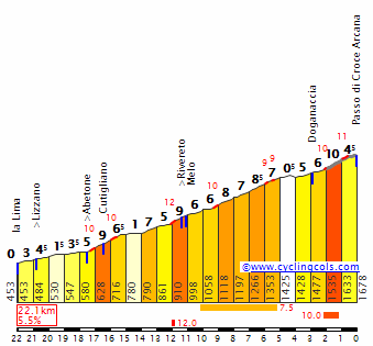
Even if this climb on it's own is not to underestimate it's its location that's worth mentioning. Maybe it is located good 35km from the top of Passo di Pennes (Auron or Isola 2000 from Bonette) but considering that Pennes north is 13km at roughly 9,3% (!) and is perfectly linked with allways massive Passo di Monte Giovo such stage could be a good contender for a queen stage in Giro d'Italia.
Profile of an eventual stage from Bolzano including Pennes and Monte Giovo.
Probability of hosting a WT race? Hope May in Dolomites will be warmer than usual nowadays.
I hope this post (or thread) will be helpful from the race designing perspective and might ease up the amount of work to put in a particular stage/race. If somebody have a MTF he doesn't know what to do with, which wasn't used or went forgotten in either real life or Race Design Thread and belongs to a major cycling area/country then he can post it here if he wish. BTW sorry for my quite poor english and thread name. I couldn't come up with anything better.


")