• The Cycling News forum is looking to add some volunteer moderators with Red Rick's recent retirement. If you're interested in helping keep our discussions on track, send a direct message to @SHaines here on the forum, or use the Contact Us form to message the Community Team.

    In the meanwhile, please use the Report option if you see a post that doesn't fit within the forum rules.

    Thanks!

Discovering Austria

...Take 2. Can the forums handle the post now the diacritic post cut-off problem has been solved?

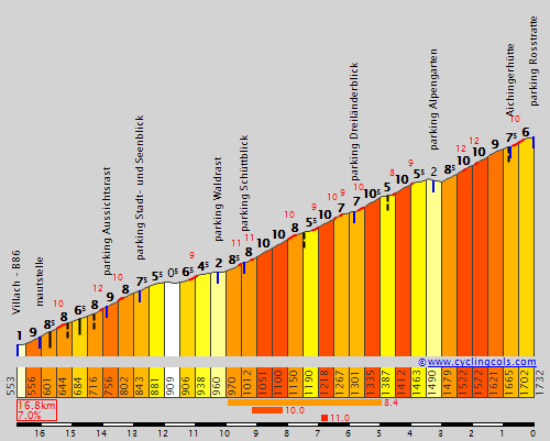
As the Tour de France approaches, naturally the Grand Boucle and its associated warmup races take up a great deal of the attentions of the cycling fanbase, for obvious reasons. But while the Tour is going on, a great deal of those focusing on the Giro or the Vuelta will have very little to do. Not many races take place in July, knowing that all eyes are in France. As such, the Österreich Rundfahrt has carved out a nice little niche for itself as "the other July race". It does have flaws; the main one being the repetitiousness of the parcours. The parcours is often not too badly balanced, although the need to finish in Vienna often means that all of the most interesting stages are bundled into the first half of the race, or they race through valleys and past a series of great climbs in order to avoid unbalancing the parcours too much. But despite the extremely broad palette of climbs that Austria has to offer, the selection utilized by the Rundfahrt is extremely narrow. Every year there is an MTF at Kitzbüheler Horn (at Alpenhaus). In 2010 they went a bit further with the Großglockner being used as an MTF for once rather than in its traditional mid-stage slot, and last year they added another MTF at Kühtai Sattel, while this year a new MTF at Dobratsch (the Villacher Hausberg) keeps things interesting.

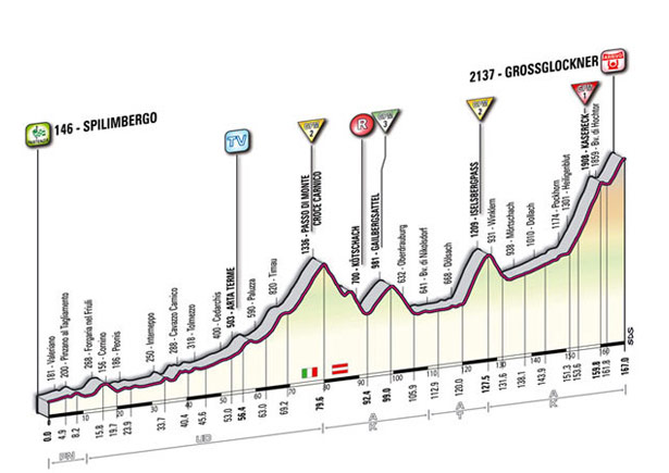
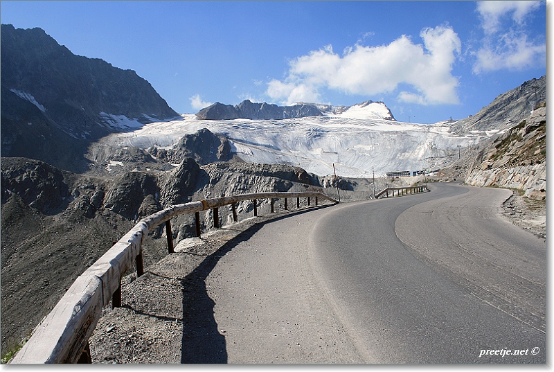
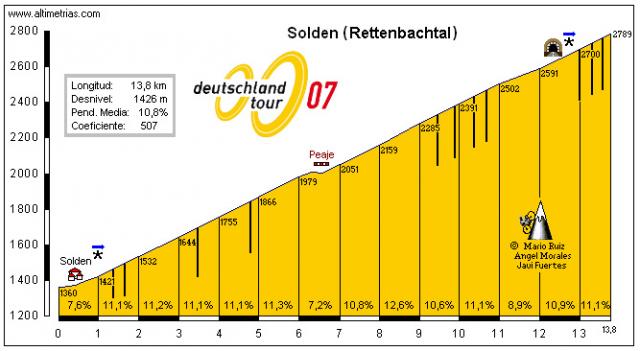
Other races have taken the opportunity to take advantage of the options Austria provides of course; the Deutschlandtour had notable major mountain stages finishing at the Rettenbachferner in 2005 and 2007, and also at Hochfügen's ski station in 2008. However, since the demise of the Deutschlandtour, these great climbs are unused. The Tour de Suisse has occasionally stepped across the border in order to climb to Serfaus, while Angelo Zomegnan has included jaunts into Italy a couple of times, even he has elected to keep things relatively sanitized, with only the one major GC stage there, the stage to Franz Josefs Höhe in 2011:

tappa_dettagli_tecnici_altimetria_13.jpg


The thing is, with its wide range of climbs and long, flat valley roads, Austria is absolutely the land out of the fantasies of both Javier Guillén and Angelo Zomegnan; the potential HC climbs range from extremely long and gradual, to dramatically inconsistent, to short but insanely, brutally steep; for some reason in Austria there are many roads to well known ski stations that decide that going by shorter routes that average some stupidly steep gradients that would make Unipublic supporters weep with joy. This thread is about discovering those climbs that could make the Österreich Rundfahrt change from "the other July race" to being a genuine killer race to start the build up to the Vuelta for riders doing the Giro-Vuelta double, and allow it to be something more than a consolation prize for those that didn't make the Tour team. It would also be nice to see what the Giro, Tour de Suisse, Giro del Trentino, a revived Deutschlandtour or even the Tour de Slovénie could do if the Austrian connection were to lead to stages across the border.

So, bearing that in mind, let us first consider how to get into Austria, since those non-Austria-specific races will presumably need to do so.

From Germany, there are few truly challenging passes entering Austria, although a few kilometres inside Germany from the border on the route between Oberstdorf and Egg the Riedbergpass clocks in at 6km @ 9,6%, which is pretty serious stuff. Elsewhere, the border between the two countries either corresponds with no passes at all or fairly easy ones - although it is very easy to access the really brutal climbs around Berchtesgaden from Austria - one side of the savage Roßfeld Hohenringstraße even begins in Austria and crosses the border early in the climb. This would connect well with Salzburg and allow the Bayern Rundfahrt to become a real, genuine tough race as I feel it ought to become - even out the 25-30km time trial with a genuinely tough mountain stage, have a hilly puncheur stage up and down around Aschaffenburg and then a couple of sprints.

Although Liechtenstein is almost all mountainous, it does not unfortunately cross into Austria at any great altitude; it is just about flat roads. Switzerland likewise, despite the attentions of the Tour de Suisse, does not have any major passes that enter into the country, although the road from Susch to Landeck crosses the border close to the climb to Norbertshöhe, which usually features on the Tour de Suisse's visits to Serfaus/Fiss/Ladis ski area. Also, the toughest route to Samnaun is the route which passes through Austria off of this route, even though the climb lies in Switzerland; there are two parallel routes into the town.

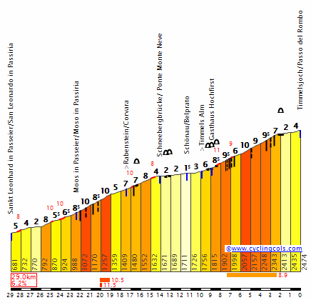
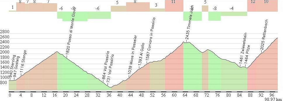
Italy offers the best opportunities in respect of entering into Austria via tough climbing; while Reschenpass is long and very gradual, it links to Stelvio; however it arrives near Norbertshöhe and has the same flaws as the Swiss route. Much more interesting is the next pass, the extremely savage Passo Rombo. Known to Austrians as Timmelsjoch, this is the toughest pass between Italy and Austria; the Austrian side we will meet later, but the Italian side is a killer 29,3km @ 6,1%, and that with some flat in the middle!!!

RomboE.gif


Yes, that's HC in anyone's language. East of that lies the Brennerpass, the most used, as the main road connecting Innsbruck to Meran, Bozen and Trento. Next up is the two-stepped Passo Stalle, which is pretty tough from its Italian side (12km @ 6,8%), however the Austrian side only averages a couple of percent on a long trip. However I am a fan of this climb for its inconsistency and also as it passes the Antholz biathlon stadium. The border can be crossed by a couple of flatter roads and the less serious Plöckenpass, but there are still some tough crossings to come, most notably the 13,4km @ 7,2% that makes up the Passo di Pramollo:

7522-1-passo-pramollo.jpg


Known to Austrians as Naßfeldpass, their side of the climb is, unlike with Rombo and Reschenpass, the tougher one. Personally I would prefer to go from Austria to Italy with this one; Naßfeldpass->Passo del Cason di Lanza->Forcella di Lius deposits us at Sutrio, so we could climb the easier side of the Zoncolan from there, or do Sella Valcalda->Ovaro.

Finally, the Slovenians can cross into Austria via the fairly straightforward Wurzenpass, or the soaring, swooping Loiblpass, although once more the Austrian side is the tougher one. Further east still, the Seefeldsattel and Paulitschsattel are next door neighbours to one another and would allow an exciting brief interlude into Austria in the Tour de Slovénie. The smaller Radlpass (just 650m over sea level) signals our last pass of any real difficulty to enter Austria; the Austro-Hungarian, Austro-Slovak and Austro-Czech borders need not detain us here. After all, we're looking for real high difficulty mountains. The kind that Zomegnan approves of. And now we've found our way into Austria, let's look for them.
 
It is perhaps best if we ease our way in to Austria by first looking at something that we know; or at least that *some* race organisers know about, if not the Österreich Rundfahrt team. And therefore we start with a climb I consider to be very underrated and seldom considered when we talk about the toughest climbs that we have seen in top level bike racing; the savage Rettenbachferner.

sized_IMG_2063f.JPG


For hobby cyclists, the ski station at the Rettenbachferner is not the end of the climbing; the Ötztaler Gletscherstraße, which we are climbing, continues on for another kilometre or two yet. However, the vast majority of this final stretch, which leads to a second station at the Tiefenbachferner, is in a tunnel, which makes it very difficult to consider for racing. Which is a shame, because we could be setting altitude records for European racing if this were accessible. Not that it isn't high enough and difficult enough to stop at the Rettenbachferner, anyhow.

oetz14.JPG


When we discuss toughest climbs in racing, we tend to think primarily of the Grand Tours, and with good reason. Short stage racing seldom sees climbs as brutally tough as Angliru or Monte Zoncolan, and often with good reason; a climb like this in a short stage race would often result in the race becoming a win-the-MTF-win-the-race kind of easy GC win for the strongest climber, as tactics are hard to enforce on a summit so difficult no real racing will go on outside of the final climb (yes, I know both have been won from the break recently, but only in races where the GC battle was either waged behind GC irrelevances (Vuelta '13) or where the GC was more or less settled (Giro '14)). Nevertheless, a one week stage race has climbed the Rettenbachferner. Twice. While Germany was still in love with cycling, the Deutschlandtour sought to expand in to Austria to take advantage of more epic Alpine climbs; while strong summit finishes were possible in Germany, as evidenced by the Feldberg climb used in 2003 and 2005, a lot of the time the smaller mountain ranges led to a range of medium mountain type stages, and so from 2004 onwards the organisers looked to their neighbours to the south to take advantage of more difficult mountain passes. In 2005, that led to the introduction of this savage and brutal climb, which was also revisited in 2007. Revisit 2005's ascent here and see Levi Leipheimer attack (a rare collector's item!) to defeat Jörg Jaksche, Georg Totschnig and Jan Ullrich. It makes me miss the Deutschlandtour; a race I truly wish could come back... there are so many possibilities for it, from savage cobbled stages in Sachsen-Anhalt and Mecklenburg-Vorpommern, Ardennes-esque monsters in the Rheinland, and around the Taunus and Aschaffenburg, sawtoothed medium mountain killers in eastern Bavaria, Thüringen, the Rhön and Erzgebirge, echelons of climbers' nightmares in Schleswig-Holstein and the Nordseeküste, and mountains to rival all but the Alpine and Pyrenean peaks in the Schwarzwald and German Alps. But that's off topic.

The climb was an instant attention-grabber. Maybe that's to do with the combination of high altitude and nightmarish gradients.

d3d5bc44.jpg


That profile, from the APM foro guys, goes from the turn-off from the Ötztal valley road to the Tiefenbachferner. The total for that is a pretty brutal 13,8km @ 10,8%. The Rettenbachferner is at the asterisk, roughly speaking - at an altitude of 2670m. Depending on where you put the start (many use the village of Sölden itself as the commencement point), Its profile can be considered 12,1km @ 10,7% or 12,4km @ 10,5%, with a maximum of a not at all inconsiderable 18%.

Do those figures sound quite familiar to you? They should, as they are incredibly reminiscent of the Mortirolo from Mazzo, one of Italy's most legendary and storied ascents. The Rettenbachferner is a little more consistent than the Mortirolo in its ascents at least (there is that very brief, barely perceptible descent in there), but this is offset by its being some 800m higher up in altitude, and do not consider that that would not be a factor in racing. Here we are higher than the Gavia, higher than Galibier... the only climbs competitive cycling is familiar with that top out above the Rettenbachferner are the Cime de la Bonette, the Col de l'Iseran, the Col d'Agnel and the Passo dello Stelvio. And if we went to the Tiefenbachferner, it tops out at 2830m and dwarfs all of these, with only Pico Veleta to defeat it.


Is it going to be used in the near future? In a word, no. Not unless the Österreich Rundfahrt's organisers become a lot more adventurous or Kitzbühel tells them to do one. A resurrection of the Deutschlandtour has been mooted a few times since its demise in 2009, but seems further away than ever at present, while the Giro has had problems with snow at high altitude in the last couple of years, and while the winter station is popular at Sölden and the road may be accessible, getting back down even in a non-competitive ride may be tricky. It is a real shame, though, as it denies us the possibility of the insanely brutal Passo Rombo-Rettenbachferner combination, with two serious HC climbs backing immediately onto one another, with 30km @ 6% followed by 12km @ almost 11%. Throw in the Passo di Monte Giovo (Jaufenpass) beforehand and you have one of the most brutal 100km ever devised by man:

2050C7A1032A50696F582C50696E16.jpg


Maybe a short run-in from Bruneck or Brixen could make this into a viable Giro stage, or at present it could be the most brutal Giro Donne stage ever created.

But this climb really needs rediscovering, because we are fully aware it can support a major race. I just wish the Österreich Rundfahrt could turn itself into one of those.
 
I wonder why didn't they go up to the end of the road at almost 2800 meters? :D It's maybe the toughest mountaintop finish in pro-cycling history (and surely in top3). And it would definitely be the hardest climb ever if the finish was at 2800. Too pity it's not longer used in pro-cycling. I didn't know that Rombo was so close to this. This double is a must for Giro ;) The best double for ages.
 
Well not exactly. Near the DeutschlandTour finish line at 2670 the road splits. One way continues to dead end at almost 2800 meters without any tunnels and a finish could be there. And the other way turns left and dissappears in the tunnel where it climbs to about 2830 meters - highest paved road in Europe after Veleta, as you said.
 
Ah yes, there is a higher car park, though all the amenities are at the 2670m station, which is probably why they finished there. Along with perhaps the thinking that they didn't want to make the race into a one-climb competition but still wanted to use the climb.

Of course, however, as long as they only finish at 2670m, even if they don't want to continue on with such a brutally steep climb, they can still go higher yet, with a completely different characteristic climb, the monolithic Kaunertal Gletscherstraße.

1272471137D_kaunertaler_gletscherstrasse.jpg


With nearly 2000m of ascent over almost 40 kilometres of hurt, this one goes in the file with the likes of Val Thorens as the most enduring, strength-sapping long climbs in Europe. But this one has a far tougher closing stretch as well as being over 400m higher up - that's right, we're going up into the Stelvio realm, finishing here at 2750m.

a26fefad3d4300868e87f40d795bf229


Like almost any genuinely challenging climb of this kind of length, the Kaunertal Gletscherstraße is not a consistent climb; it ramps up and eases back down repeatedly on its interminable length. In the Österreich Rundfahrt it may even be separated into two distinct categorised climbs, due to the 5km or so of flat where the road is following the banks of the Gepatschspeicher. Before this point even, however, the climb is about 20km at around 4,5% which undulates, including a few flat kilometres and ramps of up to 14%; shortly before reaching the lake, there is a kilometre averaging 10,5%, which is hardly to be sniffed at.

After leaving the banks of the Gepatschspeicher, however, se armó un zapatiesto. A quick 2km rise with ramps of up to 12% gives way to a kilometre of false flat, before, after all that has gone before, the final 9km average a solid 9%, the final 3 being at 10%. This is really, really nasty stuff.

Kaunertal.gif


Now, of course, you could - perhaps should argue, well, since this is a mountaintop finish at 2750m and the final 9km average 9%, of course everybody's going to leave it until then! And you will probably be right. But given in a lot of races we're seeing that kind of finish but with the whole péloton together at the base (and of a less difficult climb), what can be so bad about having that kind of finish but where you can more or less guarantee that the péloton will have been burnt down to the bare essentials by the time we get to that final 9km? Because once you get to this kind of level, and at this kind of altitude, the train that could perhaps be extremely effective early on in the climb could have burnt its matches; or the gradients get up too steep for it to truly work.

After some destructive, tangled lacets switching back and forth repeatedly, the road eventually reaches its end at a small ski station and cable car summit at the glacial tongue known as the Weißseeferner. Ski runs litter the land above us, but it really isn't as if 2750m isn't enough. But what it does mean, gloriously, is that there is all of the infrastructure needed to host a major race here at the top of the Kaunertal Gletscherstraße - it's just as feasible as the Rettenbachferner or other similar nearby roads.

Speaking of nearby roads, of course, the Kaunertal Gletscherstraße begins in the village of Prutz. This is extremely close to Ried im Oberinntal, which is the base for the not uncommon climb to Serfaus via the Serfaus-Fiss-Ladis ski area (realistically, a climb to the Fiss station would be shorter and steeper without the flattish run-in...). Though the Österreich Rundfahrt typically doesn't include any mountains this far West as it tends to try not to explode things too much before Kitzbüheler Horn, the Tour de Suisse has been here a few times... and can you just imagine how much more interesting the Tour de Suisse would have been the relevant years if instead of climbing to Serfaus, the last 10km of this stage from 2009 or this one from 2011 were replaced by a 40km behemoth? What if I also added that it could be preceded absolutely directly by the never used, extremely steep western side of Pillerhöhe (7km @ 10,2%)? Sure, the Österreichrundfahrt could also use the better-known northwestern side (9km @ 7,2%), and both would feature a technical and steep descent, but that would be a real way to ensure the riders didn't have enough left in the tank.

The only real problem with including the Kaunertal Gletscherstraße in the Tour de Suisse is that because the climb is so long you'd be seeing the best part of 100km outside Switzerland if you went from Nauders via Norbertshöhe and Pillerhöhe (or better, via Samnaunstraße, climbing only as far as where the Swiss and Austrian roads to Samnaun meet). I see a best case scenario being Davos -> Flüelapass -> Samnaunstraße -> Pillerhöhe -> Kaunertal Gletscherstraße. The Giro would have similar issues, arriving at Nauders via Reschenpass. On the other hand, the Giro would have issues with the altitude given recent problems with snow, which the Tour de Suisse in mid-June is much less likely to have. But this is far too good a climb to be completely unnoticed.
 
Jun 24, 2013
543
0
0
Visit site
Talking about the Kaunertal Gletsjerstrasse gives me a feeling of nostalgia. been there on vacation twice, at Feichten. The hairpins really follow eachother quickly after the lake, we almost got stuck there with our car :D
 
The Österreichrundfahrt pretty much every year takes a trip over the Großglockner; this is pretty standard, of course, that the race should want to take advantage of this monstrous climb. The potential that the various sides of the climb have will likely be explored later. But typically in the Österreichrundfahrt, except in 2010 when there was a mountaintop finish there, the Großglockner is placed far from the finish, and the finish is somewhere like Lienz after a descent of Paß Iselsberg. When the Giro trips into Austria as well, Lienz is thought of as being like the door to the Großglockner.

Lienz is far from being just that, though, and there are in fact a number of climbs that surround it that are right up there in terms of savagery and downright nastiness to finish off any rider. And even if the Großglockner would be placed far from home and would therefore see little real racing, there can be no doubt that the cumulative climbing would have a serious effect if organizers were to finish a race on some of these monstrous ascents.

The first of these that I shall introduce is the ascent to the Hochsteinhütte, which lie just a shade south of due west of Lienz, on the way out of the Pustertal.

2011-07-05%20Urlaub%201682%20Hochstein.JPG


There are a few similarities with the Rettenbachferner in this one... not least in its vital statistics, these being 12,0km @ 10,7%. Again, Mortirolo-esque, but this one tops out at 1990m so once more we're adding a couple of hundred extra altitude metres. The climbbybike profile helps us out a bit by adding in some numbers to illustrate the colour scheme that quaeldich goes for, however it neglects to mention that the parking area is at 1990m and the last 35m ascent are on sterrato, which is fine for a hobby cyclist but a race would have to stop at the parking area.

1053_1185_gradient_600.gif


This is an absolutely savage ascent right from the start. It starts off on nice, wide, exposed roads on the Pustertaler Höhenstraße, a tumultuous up-and-down road to link the mountainside villages of the Pustertal that sits above the main road that links Lienz to Toblach and Bressanone. The first part of this climb is to Bannberg, the first - and toughest - Pustertaler climb. And the views are unglaublich. This climb in and of itself is 5,5km at 10%, with over a whole kilometre at 13,1% and a steepest section of 300m averaging 15%. There is then a kilometre of flat to calm the riders down - but of course you know what that means, because when there are flat kilometres in the midst of climbs that average over 10% overall, the rest is going to be REALLY brutal.

The steepest part comes directly after leaving the Pustertaler Höhenstraße; the road becomes more exposed and there are 700m averaging nearly 14%, before it settles down a little, then kicks back up again with a really nasty section. However, no part of this second half of the climb is easy at all - the final six kilometres average 12%, which is up there with the Zoncolans and Anglirús of the world (almost). And the views are to die for.

img46ef17d1a8495.jpg


The road ends in a sizable car park, which would mean that there would likely be enough room to host a race here; it might be a squeeze for Il Giro, but with buses and the like able to wait at Bannberg it would be fine; with Hochstein being occasionally called in for its ski runs when Lienz hosts the Alpine Skiing World Cup there would be amenities there (and Lienz would be more likely to pay for it, having hosted both the Giro and the Österreichrundfahrt a few times recently). And it's one of those climbs where it doesn't need much to precede it, because it's going to cut the field to ribbons even without that, simply due to the grisliness of the relentless gradients. Riders will be coming in alone here.

Nevertheless, I attempted to link it up to a few other key Austrian climbs - there's no way, as I said before, that riders wouldn't leave everything until Hochsteinhütte, but we can at least ensure they're tired first:

213m9o8.png


That's Bischofshofen to Hochsteinhütte, and believe it or not that smallish first climb is Dientner Sattel, which is 16km at 5%, made to look like nothing thanks to the monolithic Großglockner and Hochsteinhütte. However, as this involves a long descent of the Großglockner and the easy side of Paß Iselsberg is under 4km in length, it's all a bit limited. It would be possible to follow the descent from Paß Iselsberg with a 25km detour which consists of the climb of Oberdrum (7,8km @ 9,0%, so very much a cat.1), the descent, and then around 10km of downhill false flat into the start of the climb.

And yet this is but one of the options for finishing on a brutal mountaintop in the area.
 
Jul 6, 2009
39
0
0
Visit site
Very good post!!!

I would like to see a stage starting in Salzburg, heading to Hallein, climb Roßfeldstaße, ride along the valley to Hintersee, head south, there is a small road through the nationalpark (Hirschbichstraße). Saalfelden and up the Großglockner to finish. If it is not long enough have them climb Gaisberg to 1000m then decend the other side at the start.
Epic day riding.
 
The next climb on our itinerary is included in a rather timely fashion - it is going to be climbed in the Österreich-Rundfahrt tomorrow, as part of their quest to try to shake things up a bit, a bit belatedly but still, good to see them trying.

The city of Villach, in southern Kärnten, is one of Austria's biggest, but it hasn't featured in the national Tour since 1992 - on the other hand it has, bizarrely, appeared in the Tour de Slovénie. It is an important city at the junction of Italy, Slovenia and of course Austria, but for cyclists that's not so much the important part (though it helps). What does matter is, it sits at the foot of the Villacher Hausberg, a lopsided mountain with a steep southern face, which is perhaps better known by the mountain's actual name of Dobratsch.

1411_2_Rote-Wand-Schtt.jpg


The road that climbs this nasty ascent - the Villacher Alpenstraße - sticks mostly to the steep edge that delineates the gradual ascent of the northern face from the jagged, rough and steep southern side of the mountain seen in the photo above. And while the climb may not be as neverending as Kaunertal, and may not match up to Hochsteinhütte or the Rettenbachferner for steepness, this is still a worthy Hors Catégorie climb. It's not super-long, and though it's never truly brutal, it is still inconsistent enough to really make people suffer.

627292448210393063712911.jpg


VillacherAlpenstrasse.gif


Also, it is worth noting that while the signs advise 10% to be the maximum, short stretches get above this, to 12 or 13%, and there are two whole kilometres averaging over 10%, as well as two short flattenings out and one brief descent en route to an overall 16,4km @ 7,1%. This one will make an interesting race in the Österreich Rundfahrt - and another bonus when considering it for other races such as, say, the Giro, is that by being located close to the border and by being, well, the Villacher Alpenstraße, it leaves you with a city with the money to pay to host a stage (and probably the start the next day) with a serious mountain just rising out of it.

If race organisers wanted to be really sadistic, the road continues on dirt paths up to over 2100m to the ÖRF-Sender Villacher Alpe, however the main parking place is at just 1732m - though there is plenty of space. And of course, we know that the climb is suitable for major races, because a 2.HC race will be finishing a stage there... tomorrow.

26793492.jpg


And with a climb that has been going up and down through the gears for 13km then featuring two of its final three kilometres at an average of 9,8%, we can certainly expect time gaps from the Österreich Rundfahrt there.

The weird thing with the Villacher Hausberg, however, is that strangely enough given the geography of Austria, it is hard to link to connecting climbs. Many tough climbs are hard to link to equivalent connectors - Kitzbüheler Horn for example could be easily linked to Gerlospass and Paß Thurn, it's just that neither are in its league for difficulty. Dobratsch is even harder; owing to the location of Villach at the confluence of the Gail and Drau rivers, with rolling land to the east and two major valleys to the west and northwest, the need for major passes nearby has been minimal, and so neighbouring mountains tend to have just one route up, same as Dobratsch - some of which we may meet before this thread is complete. Perhaps the best we could hope for would be a Giro stage with Sella Nevea, Passo del Predil, Passo della Moistrocca (Vršič), Würzenpass and then Dobratsch...
 
I really think that the Kitzbühler Horn and the Großglockner destroyed the österreich rundfahrt because they want to have these two climbs in the course every year. So there is only place for one more mountain stage an that is not very much. The sad thing is that austria has so many great passes which have never been used in the Österreich rundfahrt. Here is a short list:
0.(name of the climb/side (N means north, E means east,...)/category)
1.Bielerhöhe/W/1st
2.Furkajoch/N,S/1st,1st
3.Faschinajoch/N,S/1st,1st
4.Hochtanbergpass/W/1st
5.Hahnetnjoch/E,W/HC,1st
6.Kühtaisattel/E,W/HC,HC
7.Pillerhöhe/E,W/1st,1st
8.Zillertaler Höhenstraße/NE,SE/HC,HC (not sure if its possible to use it)
9.Gerlospass/E,W/1st,1st
10.Felbertauern/N/1st
11.Pustertaler Höhenstraße/E/1st
12.Großglockner/N,S/HC,HC
13.Dientner Sattel/E/1st
14.Obertauern/N/1st
15.Turracherhöhe/N,S/1st,1st
16.Nockalmstraße/S,NW/1st/1st
17.Eisenhöhe/N,SW/1st,1st (Eisenhöhe is the second mountain of the nockalmstraße)
18.Katschberghöhe/N/1st (extremely steep)
19.Hochrindl/E/1st
20.Simonhöhe/S/1st
21.Sölkpass/N,S/1st,1st
22.Soboth/E,W/1st,HC
23.Weinebene/E,W/1st,HC
24.Silzer Sattel/N/HC
So that are all passes that come to my mind at the moment. I only mentioned the passes which would be 1st category or higher and are completely in Austria (so no Timmelsjoch)and again: These are only passes, so none of these would be used as a mtf
(N means north, E means east, etc.)
 
Jun 30, 2014
7,060
2
0
Visit site
You can use Höhenstraße without any problems and have a great descent finish, just like Fauniera said you have multiple brutal ascents that are linked by a nice road, I've designed a nice Giro stage with the Zillertaler Höhenstraße, if it wasn't for the problems with the race design thread I'd have posted it already.
The stage would be something like this: http://www.openrunner.com/index.php?id=4363421 maybe i'd make the penultimate descent shorter, so the final climb would be 3,6km at 10,7%, instead of 6km at 10%.
Libertine already introduced Hochsteinhütte, but there are at least 2 other brutal climbs around Lienz that could be used as a MTF, Zettersfeld (10,5km at 11,4%) and Lienzner Dolomitenhütte (7km at 13,6% :cool:)
The profile for Dolomitenhütte: http://climbbybike.com/profile.asp?Climbprofile=Dolomiten-H%FCtte&MountainID=1272
Zettersfeld: http://climbbybike.com/profile.asp?Climbprofile=Zettersfeld&MountainID=1296
 
Yea, I could have gone a long way further with this thread. I was going to do all four of the Lienz quartet, Zettersfeld, Dolomitenhütte, Hochsteinhütte and Faschingalm.

Personally my favourite use of the Zillertal Höhenstraße would be a stage that did Melchboden from Hippach then descended and finished with the two-stepped climb of Hochfügen - the bottom of that climb is very steep but the second half very gradual, encouraging more attacking further out and making the savage first half of Hochfügen more nightmarish for riders only just recovering from the brutality of the Zillertal.

I had dozens of epic stage designs created, with the idea that Zomegnan needs to take over the Österreich Rundfahrt.

For a not-quite-high-mountain type stage, the combination of Pillerhöhe and the Hoch-Imst station is good, but you could always do Seefelder Sattel-Silzer Sattel-Hoch-Imst instead. Silzer Sattel is a fantastic climb that could be a warmup in a Rettenbachferner stage (the old Deutschlandtour stages always used Kühtaisattel), or even better, climbing Kühtaisattel west via Silzer Sattel is 19,2km at 7,7% including some descent (!!!) and could lead to a descent finish in Innsbruck or an MTF at Axamer Lizum.

I would argue Timmelsjoch North, while nothing like as tough as its Italian side, is still a genuine climb that could be considered HC (around 20km at 6%). My main problem with the Österreich Rundfahrt for the Race Design Thread is similar to that with the Giro. I've done several Vueltas and Spanish stage races because there are good ways to improve the way the race is going. But with the Giro, and the Österreich Rundfahrt (and the Tour de Suisse), the sheer number of great climbs that I want to get into the race is just too high. You could have a three week mountain race in Austria and still leave options unexplored, but the number of super-steep but not especially long climbs seem to be a feature of the Germanic Alps (there are a number of such climbs in both Germany and Austria, the likes of Nebelhorn, Kitzbüheler Horn, Idalpe, Dolomitenhütte etc.) whereas the number of high multi-sided passes that can be chained together like in France and southern Switzerland is sometimes lacking.

Oh, there's also Steinplatte, another brutal ascent of 7km at over 12%, in the north of the country, Dachsteinstraße, the absolutely MONSTROUS Gerlitzen Panoramastraße (13,9km @ 10,0% and just across the road from the Dobratsch ascent mentioned above). It could be used in a Giro, sort of. Sella Nevea-Passo del Predil-Passo Vršič-Würzenpass-Gerlitz ->

mij69v.png


There's also the border pass at Naßfeldpass, which I am a known fan of, the short and steep Falkert-See, Klippitztörl which is a nice tall pass that could lead into either Weinebene or one of the stopoff stations on the way to Großer Speikkogel (not enough room at the top of that, but it's 15km at over 10% - they could feasibly stop at Hipfelhütte, which is about 11km up, same as they don't do all of Kitzbüheler Horn). Gaberl and Altes Almhaus are another double act. Hochkar is another 11km at 9% although with little room at the top. I'm also a big fan of Stoderzinken backed directly out of Sölkpass. at 12km at just under 9% it isn't quite the same level of carnival gradients as some, nor as long as others, but strikes a good middle balance for tough racing. Up to the north there's the Trattberg Panoramastraße, and Salzburg's Hausberg, the Gaisberg. This is hardly a brute (11km at around 7,5%) but can be linked to the German monsters in the Berchtesgadener Land (Hintenbrand 5km @ 13%, Roßfeld Panoramastraße 11km @ over 9%) if they wanted to liven up the Bayern Rundfahrt (a race that uses its terrain even worse than the Österreich Rundfahrt, and might even be a contender for the award of "worst designed race of all time" given how bad it typically is compared to how good it could be).
 
I think one of the most interesting parts of austria is in the south of "Steiermark" and the north of "Kärnten". There are some great mountains like the Nockalmstraße, the Turracher Höhe, Obertauern, the Katschbergpass,...
Here is a stage I created in this area
the mountains are: Sölkpass-Ramsau-Obertauern-Katschberg-Eisenthalhöhe-Nockalmstraße-Falkert
 

Attachments

  • Murau-Falkert.png
    Murau-Falkert.png
    126 KB · Views: 4,216
Jun 30, 2014
7,060
2
0
Visit site
Gigs_98 said:
I think one of the most interesting parts of austria is in the south of "Steiermark" and the north of "Kärnten". There are some great mountains like the Nockalmstraße, the Turracher Höhe, Obertauern, the Katschbergpass,...
Here is a stage I created in this area
the mountains are: Sölkpass-Ramsau-Obertauern-Katschberg-Eisenthalhöhe-Nockalmstraße-Falkert
That stage looks very nice, how hard is the final climb?
 
There is an insanely steep climb to go to the Eagle's Nest in Germany, but it is very near Austria. The history behind it is very interesting, and the road reaches 27% and then 30% later on. It climbs 1000+ metres. There will be complaints for sure, but the race up it will be fantastic.
 
Jun 30, 2014
7,060
2
0
Visit site
Re:

Brullnux said:
There is an insanely steep climb to go to the Eagle's Nest in Germany, but it is very near Austria. The history behind it is very interesting, and the road reaches 27% and then 30% later on. It climbs 1000+ metres. There will be complaints for sure, but the race up it will be fantastic.
It would be a great climb, but I don't think that people in Germany would want to use that place as a MTF
 
Re: Re:

Mayomaniac said:
Brullnux said:
There is an insanely steep climb to go to the Eagle's Nest in Germany, but it is very near Austria. The history behind it is very interesting, and the road reaches 27% and then 30% later on. It climbs 1000+ metres. There will be complaints for sure, but the race up it will be fantastic.
It would be a great climb, but I don't think that people in Germany would want to use that place as a MTF
Understandably, it was the summer home of the worst human to have lived, but with a PR spin then it could work out.
 
Mayomaniac said:
Gigs_98 said:
I think one of the most interesting parts of austria is in the south of "Steiermark" and the north of "Kärnten". There are some great mountains like the Nockalmstraße, the Turracher Höhe, Obertauern, the Katschbergpass,...
Here is a stage I created in this area
the mountains are: Sölkpass-Ramsau-Obertauern-Katschberg-Eisenthalhöhe-Nockalmstraße-Falkert
That stage looks very nice, how hard is the final climb?
It is 7.3 km with 10,7%
By the way, you can also use the Turracher höhe instead of falkert, that climb would be 6,8 km long with a gradient of 10%. So the climb is a little bit easier but there is no flat section between the descent and the ascent
 

TRENDING THREADS