Giro d'Italia Giro d'Italia 2025: Stage-by-stage analysis

It’s that time of year again. The amore infinito of cycling fans for all things Giro has been tested repeatedly in the past few years, will this be the year the flame is rekindled?

Judging by the route, it can go both ways. It has very few out-and-out sprint stages, but the same is true for the number of GC days. It has what are unquestionably the two most exciting GT stages all year, but at the same time RCS have shot themselves in the foot with not one, but two designs. It is certainly the most unusual GT route in a long time, and no matter whether things go really well or really poorly, there are things that people can go back to and say: ‘of course it was going to go this way given the route’.

Those debates are for later times though, first we have three weeks of hopefully exciting racing to look forward to. In the meantime, I hope you all enjoy this thread. Warning in advance: I had a lot of time to work on the cultural parts and not as much for the cycling parts and it definitely shows.

Percorso-Giro-dItalia-2025.jpg


DayStageStartFinishDistanceElevation gainRatingStarts atETA
Fri 91DurrësTirana160.0k1800m***13:3017:03 – 17:25
Sat 102TiranaTirana13.7k (ITT)150m***13:5517:14
Sun 113VlorëVlorë160.0k2800m***13:2517:02 – 17:26
Mon 12R1
Tue 134AlberobelloLecce189.0k800m*13:0517:01 – 17:23
Wed 145Ceglie MessapicaMatera151.0k1550m**13:5017:03 – 17:21
Thu 156PotenzaNapoli227.0k2600m**11:5017:00 – 17:31
Fri 167Castel di SangroTagliacozzo168.0k3500m****12:5516:59 – 17:30
Sat 178GiulianovaCastelraimondo197.0k3800m***12:2516:59 – 17:30
Sun 189GubbioSiena181.0k2500m***13:0517:00 – 17:24
Mon 19R2
Tue 2010LuccaPisa28.6k (ITT)150m****13:1517:14
Wed 2111ViareggioCastelnovo ne’ Monti186.0k3850m***12:2016:57 – 17:33
Thu 2212ModenaViadana172.0k1700m**13:2517:04 – 17:26
Fri 2313RovigoVicenza180.0k1600m**13:0516:59 – 17:23
Sat 2414TrevisoNova Gorica/Gorizia195.0k1100m**12:5517:03 – 17:27
Sun 2515Fiume VenetoAsiago219.0k3900m****11:3616:53 – 17:32
Mon 26R2
Tue 2716Piazzola sul BrentaSan Valentino203.0k4900m*****11:3516:53 – 17:37
Wed 2817San Michele all’AdigeBormio155.0k3800m***13:0016:57 – 17:28
Thu 2918MorbegnoCesano Maderno144.0k1800m**14:0017:03 – 17:21
Fri 3019BiellaChampoluc166.0k4950m*****12:3016:57 – 17:34
Sat 3120VerrèsSestrière205.0k4500m*****10:5015:55 – 16:34
Sun 121RomaRoma143.0k600m*15:2618:38 – 18:54


(official material credit: RCS, climb profile credit: cyclingcols, Climbfinder, salite.ch and in two instances, myself)
 
Last edited:

Stage 1: Durrës – Tirana​

The race’s opening act connects the country’s two largest cities. They are close enough to be linked by a proper-length ITT, but seeing as this is both the first stage and 2025 a road stage makes much more sense, and so that’s what we’re getting. It doesn’t have the elevation gain to be considered a mid-mountain stage, but this is still far from an easy opener.

Map and profile

qSu5g4Oxev8rAm6emNIN_280425-012259.jpg


5QneN9X6DUAOlJDMH66S_280425-012422.jpg


Start

The first-ever major race on Albanian soil starts from Durrës, the country’s second city and main port. For the purpose of this project, it’s rather fortunate that the Giro has chosen Durrës for the first stage start, because to the 99% of you unfamiliar with Albanian history, I’m going to have go through a little bit of it to make sense of my city writeups and there really isn’t a better place to start than the city that was the most important in ancient times.

And no, unlike RCS, I am not going to be using the Italian names anywhere – I’m very glad I set that precedent for myself in the 2024 Tour analysis, because… well, we’ll cross that bridge when we get there.

Durrës was founded by Greek colonists as Epidamnus in 627 BC. It was already a prosperous port long before it became one of the first cities outside modern Italy to fall under Roman control in the late 3rd century BC. This turned out to be an enormous boon to the city, as the Romans chose it as the starting point of the Via Egnatia, which connected it to Constantinople. Together with the Via Appia and the short sea voyage from Brindisi to Durrës, which was rechristened as Dyrrachium, this was the main route from Roma to the east. This made it not just a key economic hub, but also of great strategic importance. Most notably, it was the site of the first major battle in Caesar’s civil war in 48 BC (Pompey won, but failed to land a decisive blow, he then pursued Caesar all the way to Pharsalus in Greece… the rest, as they say, is history). In the Byzantine era, Durrës remained significant as a key link between east and west, but decline was inevitable in the turmoil of the post-Roman world. Repeated conquests in the second half of the Middle Ages, when the Byzantines, Bulgarians, Normans, Venetians, Sicilians, Serbs and the Albanians themselves all held the city at least once, accelerated the decline. The final nail in the coffin were the decades when Dürres was the last Venetian holdout in an Albanian coastline otherwise entirely conquered by the Ottomans, and upon its fall in 1501 it became rather unimportant for the next centuries.

After dwindling to just 1000 inhabitants by the mid-19th century, Durrës finally rebounded in the final decades before Albanian independence in 1912. However, Albania was one of the weakest states in the region and with first the Balkans and soon thereafter all of Europe engulfed in war, Serbia, Bulgaria, Italy and Austria-Hungary all occupied at least part of the country for a time during the first post-Ottoman years. Durrës, which saw military action and damage on multiple occasions during this period, served as the capital for a time, until Tirana was established as such in 1920. After the First World War, a highly unstable Albania remained under simultaneous pressure from Greece, Yugoslavia and especially Italy (who occupied Durrës for a time – this is why the capital was moved), and only American diplomatic intervention preserved its independence. The Yugoslavs enabled the permanent ascension of the Zog (later King Zog I) in 1925, but his autocratic regime soon turned to now-Fascist Italy for support. While the influx of Italian money was of particular benefit to Durrës, which established itself as the main port and tourist destination in this period, political and economic support soon turned to dependence and exploitation. Zog I eventually attempted to put up resistance, but was unable to do so and thus it should come as no surprise that the eventual annexation in 1939 was swift. For Albania, therefore, World War II was characterised by forced Italianization at the hands of the fascists – hence why it totally isn’t problematic that RCS are calling Durrës Durazzo, especially not given that this Grande Partenza is taking place in the light of renewed rapprochement between Albania and an Italian government led by the direct successors of said fascists.

Oh, right, I’m not supposed to get too political on this forum. In any case, Italian control of Albania ended with the collapse of the Mussolini government in 1943, and while the Nazis propped him up as a puppet in Northern Italy, they took direct control of Albania. Occupation finally came to an end the year after, when a communist resistance force liberated the country. In spite of the main theatres of war being far away, three percent of the population did not survive these five brutal years. Initially, Yugoslavia gained significant control once more, but this period abruptly ended with Tito’s falling out with the USSR in 1948. Communist Albania was led for most of its existence by Enver Hoxha, a hardliner even by communist standards. Hoxha, the kind of guy who claimed Tito was an anti-Marxist, split from the Soviets over what he saw as the betrayal of Stalin’s legacy in 1956, and followed the exact same pattern with China in anger at Nixon’s visit to the country in 1972. In part because of his repeated alienation of just about everyone else, Hoxha was noted for his paranoia, and nothing exemplifies this as well as the 750000 bunkers his government famously built all over Albania. Needless to say, none of this helped the country, and by the time of his own death in 1985, Albania was both the poorest and the most isolated country in Europe, to say nothing of the severe repression he inflicted on his people. But hey, at least Hoxha got to claim his was the last true communist government in the world.o

In spite of a more or less peaceful transition away from dictatorship, the post-communist era got off to a particularly bad start in Albania, with increasingly corrupt governments at best turning a blind eye and at worst covertly supporting pyramid schemes in which possibly more than half the population invested. Everything came crashing down in 1997 and the country largely fell into violent anarchy as a result. By the time UN forces had restored a semblance of order, an estimated 2000 people had been killed. However, the 21st century has seen continuous improvement, and for all the troubled history, growing pains and myriad other issues, at least Albania has finally shed its decades-long status as the poorest country in Europe. Durrës itself, with its orientation towards trade and tourism, has benefited particularly well from the end of isolationism. And between the Roman amphitheatre and the early Byzantine fortifications (the legacy of Emperor Anastasius I, who was born in the city), it has plenty of surviving history to show off too.

Amfiteatri_i_Durr%C3%ABsit_nga_droni_1.jpg


(picture by Agonsta24 at Wikimedia Commons)

Route

Okay, that wound up being a lot less like my usual introduction and more of a Libertine in the Race Design Thread-esque dissertation than I’d anticipated. To those of you who stopped reading it halfway through: welcome back, I promise I’ll talk about cycling now.

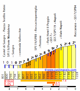
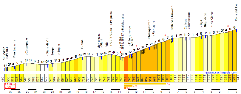
The first third is entirely flat, initially heading south through the coastal plains and then turning east to head up the Shkumbin valley. This section contains both intermediate sprints, in Paper and on the outskirts of Elbasan, Albania’s fourth-largest city. Rather than heading into the city proper, the route heads north here to climb out of the valley up the first KOM of this edition: Gracen. The first 10.7k of this climb formed the MTF of the 2023 Tour of Albania, won by Max Stedman. Its elevation gain is decent, but the gradients are quite unremarkable.

I would also like to point out that the URL for the image below reads 2025/03. Just in case you were wondering if there’s any good reason we didn’t get the full route until a week and a half before the race.

M0R2otKTBHVHbEwag02Z_280425-012803.jpg


Even though this was the main road to Tirana prior to the opening of the motorway, the descent is actually technical in parts. The road to the capital goes through the low pass at Sauk, which is the location of the totally-not-a-conflict of interest time bonification sprint. Unlike in previous years, the bonification sprints hand out six, four and two seconds for the first three riders.

By the time the riders have made it to this sprint, they are well within the Tirana suburbs, but that doesn’t mean they’re about to finish yet. Because if there’s one thing RCS love this edition, it’s local circuits. On this stage, we do almost two full laps (the first lap is missing the first few hundred metres, as they join the route right after the finish line). The main feature is the KOM at Surrel, which is 4.9k at 5.5% if you exclude the initial false flat. All the difficulty is in the ramp after said false flat.

AuPdVrxYCAAK6q9FfRwY_280425-012806.jpg


Finish

The descent looks twisty on the map, but isn’t particularly challenging. It ends at 4.3 kilometres from the line, where it turns to a false flat (1.4% on average) that lasts until inside the final kilometre. The final turn, at 500 metres from the line, takes the riders away from the Lanë river, past the Tirana Pyramid (the last and perhaps most famous of the communist era building projects) and onto the main boulevard. It looks like it drags uphill on Streetview, but thanks to Albania’s surprisingly good geoportal I was able to measure it and find that it averages a whopping 0.7%.

M4iwAGGq4Xpi8nW4Zgef_280425-012801.jpg


KXpMsl35JmGl9j1FExoT_280425-012529.jpg


And now it’s time for something I’m very glad I didn’t have to do at the start of the post: talk about Tirana. It’s not that I have anything against the city, but rather that it plays no role in Albanian history until it became the capital almost by happenstance in 1920. Founded by the Ottomans in 1624, it had grown to about 10000 inhabitants prior to independence, but remained more of a provincial town in the shadow of older, larger cities like Shkodër, Vlorë and of course Durrës. So why exactly was it chosen as the capital city? As I mentioned in my long introduction, the Italians had seized Durrës and all the other main cities (if not also under occupation) were just as easily accessible from the sea. A temporary capital was therefore needed, and thanks to its central location and the existence of at least some buildings to house the government, Tirana got the nod. This arrangement was then made permanent in 1925, and only after that did the city really start to grow. Hence, modern Tirana is almost entirely less than a century old, a mixture of the heavily fascist-influenced original city plan, Hoxha-era highrise, postcommunist (re)development and often-illegal urban sprawl, together combining for a city with almost four times the population of any other Albanian city.

Boulevard_D%C3%ABshmor%C3%ABt_Tirana.jpg


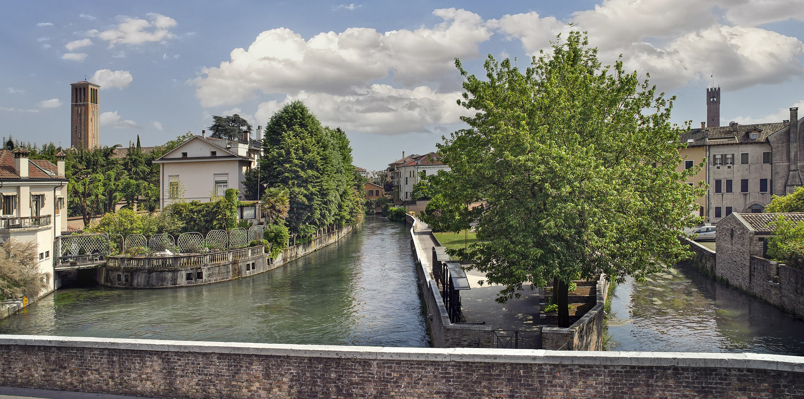
The entire final straight. They use the right half for the finish, then loop around Mother Teresa Square (in front of the polytechnical university in the background) and come down the left half to start the circuit. (picture by Radosław Botev at Wikimedia Commons)

What to expect?

Attacks on the final climb are inevitable, but chances are things come back together for a sprint of anywhere between 30 and 60 riders.
 

Stage 2: Tirana – Tirana​

As per usual with a foreign Grande Partenza, there’s a short time trial. It’s a very typical route for a second-world capital city, with lots of out-and-backs along main thoroughfares. Normally that would make it ideal for the powerhouses, but this time they have a hill to contend with.

Map and profile

Nw2JIlzG5GAFkGM2g5gh_280425-012554.jpg


ufJPp0yx1szvbUZB6AKh_280425-012326.jpg


Route

The stage starts on Skanderbeg Square, the other main Tirana landmark. After looping around and then south, we have a section along the Lanë river and the inner ring road, before the route turns back on itself for the first time. The riders then pass very close to the finish, heading through Mother Teresa Square and around the new football stadium which hosted the inaugural UEFA Conference League final in 2022, and then onto the road towards Elbasan. This means we are going back up to Sauk, from a different side than in the previous stage, and this time with the sole time check and the KOM at its summit.

UblCL7Y.png


Finish

The remainder of the stage is almost entirely on roads already used the day before. There is one more out-and-back along the Lanë to be had, and after the turning point the final 2 kilometres are exactly the same as on stage 1.

HsftHR7SiABGF8kWeQCS_280425-012828.jpg


gnKZkSj6uKhSXRgsmxCV_280425-040649.jpg


Skanderbeg_square%2C_Tiran%C3%AB%2C_Albania_.jpg


The sprawling Skanderbeg Square is named after the Albanian national hero of the same name (Skënderbeu in Albanian). In the face of the rapid Ottoman expansion of the 15th century, Skanderbeg united an array of local lords in what is now northern and central Albania and, in later years together with the Venetians, managed to hold off the Ottomans for a full quarter of a century. After his death in 1468, the fragile coalition collapsed and the Ottomans completed their conquest of Albania a decade later (save for Durrës, which the Venetians held onto for a few decades). Skanderbeg was more or less mythologised by Albanian nationalists from the late 19th century onwards and the modern Albanian flag is based on his family’s coat of arms (picture by Meriboo at Wikimedia Commons)
 

Stage 3: Vlorë – Vlorë​

The final stage on Albanian soil features both the hardest climb and the best scenery,

Map and profile

K0SOR3bGIvr2SzIO93Nj_280425-015225.jpg


AfKaWpke3h2Y2fFDMapn_280425-015027.jpg


Start

If you’ve been to the largest and second-largest cities in the country, where do you go next? You guessed it, this is the third-largest city in Albania. Just like Dürres, it was founded by the Greeks in the 7th century BC. As the closest harbour to Italy on the entire eastern Adriatic coast, it is actually quite surprising that it didn’t become the main port of the region following the Roman conquest, especially given how perilous sea voyages were at the time, and I can’t find any evidence on why the Via Egnatia started from Durrës rather than here. As a consequence, it remained a secondary port until the arrival of the Ottomans reversed its fortunes. What is now southern Albania fell to the Ottomans some sixty years before the areas further north (courtesy of Skanderbeg), and by the time Durrës was finally conquered, Vlorë had already been in Ottoman hands for almost a century and trade had long since mostly diverted here. It held the status of main Albanian port throughout the Ottoman age, although it eventually stagnated together with the rest of the empire. In 1912, independence was formally declared here and it served as the country’s first capital. This abruptly came to an end in 1914, when Italy seized the city. When occupation finally ended in 1920, the centre of Albanian gravity had shifted decisively away from the south and so Vlorë fell behind Durrës once more. Modern Vlorë remains mostly reliant on its port and on tourism, mirroring Durrës just as much as it did when both cities were founded 2700 years ago.

Vlor%C3%AB%2C_Albania_31_December_2022_-_Independence_Monument.jpg


I couldn’t find a picture of the cityscape I was happy with, so enjoy the independence monument instead. (picture by Sharon Hahn Darlin on Flickr)

Route

A stage in two halves: first the inland section heading south out of Vlorë, then the seaside section back into town. Contrary to what you might expect, the inland section is by far the easier, as it follows the Shushicë valley most of the way. The only point of note is the intermediate sprint in Gjorm. However, to get from the valley to the coast, the only way is via Qafë Shakellës, a two-stepped climb with a nasty first section.

shakelles-kuc-buronje.png


The coast we are descending to is the Albanian Riviera, the main tourist destination within the country. With the mountains rising up immediately out of the sea, the road along it is never flat, and immediately after the bonification sprint in Himarë it takes in the first ‘only the Giro and the Tour of the Alps wouldn’t categorise this’ climb of this edition, Qafa e Vishës.

maja-skularit-himare.png


The section after this climb looks like a bit of respite on the profile, but it’s actually pretty tricky with constantly twisting roads, some surprisingly tricky descents and a 2.2k at 6.7% climb with the final intermediate sprint part way up. Then, it’s time for the main obstacle of the day, Qafa e Llogarasë. This is the only major mountain pass near the Albanian coast, and due to the often-deplorable state of the road network (and infrastructure in general) in the interior, it is the defining climb in Albanian cycling. In fact, editions of the national tour can generally be divided into two groups: those that climb it, and those that don’t, because the latter rarely feature any real climbing (the only recent exception being that long climb they did on stage 1). In the Tour of Albania, it is most commonly seen from the other side, on stages from Vlorë to Sarandë, however last year they organised a MTF from this side on a stage that also started from Vlorë and featured the exact same route from there to the pass. Of course, here it comes almost 40 kilometres from the line, but it should still rule most of the peloton out of contention. RCS forgot to upload the official profile to their own site, thanks to Netserk for providing a non-grainy upload.

mg9F5OH.jpeg


Llogara_Viewing_platform_from_above.JPG


Qafa e Llogarasë near the summit. The island in the distance is Corfu/Kerkyra. (picture by Albinfo at Wikimedia Commons)

Finish

The descent is fairly testing until they join the new highway at about 400 metres of elevation. The remainder of the stage, along the Bay of Vlorë, is mostly featureless. This is the one stage where I really wish they had added yet another local circuit (there is a nice, well-paved murito out of Vlorë to Kaninë Castle), but sadly no dice.

p1mQqTRiwiklVZAMReNF_280425-015514.jpg


KCrXpZgiFRDZsQLDfyjb_300425-124155.jpg


What to expect?

The final climb should be too far from the finish for GC action, but it will also daunt any non-climber. Therefore, even though it’s only stage 3, this looks like a great opportunity to offload the pink to a non-threatening breakaway. If not, then probably an even smaller sprint than on stage 1.
 
Last edited:

Stage 4: Alberobello – Lecce​

With the exception of the final parade, this is the easiest stage of the race. It takes the riders deep into the heel of the boot, which I will refer to in the rest of this post by its actual name: Salento. This is the flattest part of Italy other than the Po Valley, but it has one thing going for it from a cycling perspective: the wind does blow here sometimes…

Map and profile

t1lTTWUvfmcjK41sJiIi_280425-022354.jpg


i5EAkheCIxzqAGGqNlAX_280425-022205.jpg


Start

The race’s return to Italy is marked by a visit to one of Puglia’s quintessential tourist destinations: Alberobello. The town is mainly notable for one thing, and those are its Unesco-inscribed trulli. Trulli are round, unmortared houses that can be found throughout this part of Apulia, but they are far more numerous here than elsewhere. Their origin remains unclear: the most common theory is that the local lord forced the local peasants to construct dwellings without the use of mortar. The supposed reason is that such buildings could easily be torn down and therefore formed a loophole in the taxation the lord was subject to, but that doesn’t explain why most surviving trulli were constructed after the settlement was recognised as a town (and thereby freed from feudal obligations) in 1797.

The only other thing Alberobello might have been known has, for reasons that are obvious immediately, not been promoted in the way the trulli are: from 1940 to 1943, the Mussolini regime installed a concentration camp just outside the town. After the Allied invasion, prisoners of war were held here, before its final use by the postwar government as a camp to inter “undesired”, mostly female refugees until the site was shuttered in 1949. The latter episode was notorious enough at the time to inspire the 1950 film Donne senza nome (Women without a name).

As the first stage host in Italy, this is also the first place on the route that has been visited by the Giro before: Caleb Ewan won his first of a career five stages here in 2017. Italy also organised the men’s road race here as part of their very spread out national championships in 2022, with Filippo Zana taking the tricolor home.

Alberobello_-_The_Trulli_of_Alberobello_-_20170607014105.jpg


(picture by FrancescaRM74 at Wikimedia Commons)

Route

The stage starts with a loop around to the east to take in the easiest Giro KOM on Italian soil I’ve seen for years, in the town of Putignano.

putignano-via-sant-antonio.png


Following that brutal climb, it’s a short hop to the next tourist hotspot, Castellana Grotte. As the name suggests, the town’s name has been adapted to reflect the presence of one of Italy’s best-known caves. By this point, the coast is near, although we won’t see a whole lot of it due to the Giro doing its thing of sticking to the highway because of the abysmal state of southern Italian infrastructure in this part of the stage. The most notable stopoffs in this part of the stage are the intermediate sprint in Polignano a Mare (birthplace of Domenico Modugno, the original singer of Volare/Nel blu, dipinto di blu, which was the first of his record four Sanremo Festival wins) and the fortified port of Monopoli, which happens to be one of the twin cities of Sunday’s stage host Vlorë.

Upon heading inland and entering Salento proper, the riders pay a visit to yet another popular tourist destination: the white-walled town of Ostuni. However, this time there is plenty of cycling to talk here. In 1976, it organised the World Championships, and as this was the height of Freddy Maertens’ brief reign of terror there was really only one outcome here. The other notable part of this edition was the incredibly long lap of 35 kilometres: second only to Roma 1932 as far as ‘main’ circuits go, with only Imola 2020 (28.7k) and Zürich 2024 (26.9k) having come remotely close since. The Giro uses part of the same lap here, first passing through the finish line (which was not actually in Ostuni proper, but in the village of Montalbano), then taking on the main climb of that edition (a whopping 1.5k at 5.1%) into town. At its summit, there is the bonification sprint.

Ostuni also marks the easternmost extent of the low Murgia range, which is left definitively in the next town over (Ceglie Messapica, which will host the start of the stage after this one). Aside from a small ridge which the riders cross in Oria, dominated by its hilltop castle and cathedral, there really isn’t a hill in sight for the rest of the day. On the flip side, the landscape starts to open up after said ridge, the turning point being somewhere around Torre Santa Susanna at 64k to go. One town over, we have the final intermediate sprint in San Pancrazio Salentino. Otherwise, there is very little to talk about (at least by Italian standards) from either a technical or a cultural perspective in this final third of the stage, so we can safely skip ahead to dissecting the finish.

Finish

Final circuit number two, looping from the city centre to the football stadium and back. It’s a bit of a technical finish, with the key points being a sharpish right turn immediately backing into an easier left turn right before the flamme rouge, which should string things out ahead of the sweeping roundabout at just 300 metres from the line. To any sprinters smarter than the Ronde van Limburg bunch, it should at least help that they get a dry run.

iqaEAxfIfd1zuUjoXvZQ_280425-022640.jpg


dKWJIabHDYsD3HfaQ85S_280425-022512.jpg


The history of Lecce is an ancient one, as it was already a genuine town prior to the Roman conquest of Salento in 266 BC. Despite this, it doesn’t really play an important role until much later, existing first in the shadow of Brindisi, the endpoint of the Via Appia, then as the Migration Era started to take its toll in that of the more easily defensible port at Otranto. After the Gothic years upon the dissolution of the Western Roman Empire and the (re)conquest of Italy by the Byzantines between 535 and 554, Salento’s path diverges from most of the rest of Italy: whereas Byzantine rule proved short-lived in large parts of the peninsula, Lecce and most of the rest of the Salento remained in their hands almost continuously until its conquest by the Normans in the 11th century. Lecce fell in 1058, but this soon proved to be a blessing for the town, as it became the seat of a county that eventually grew to be the largest in the region. In the 15th century, its autonomy came to an end as the Kingdom of Napoli took over. Once again, this turned out to be a boon: as Napoli became one of Europe’s largest and most prosperous cities, Lecce profited too, becoming one of the largest cities in southern Italy. Its peak came in the 17th century, when it was one of the centres of the Baroque, and the city is famous for its well-preserved architecture from this era. As the Kingdom of Napoli was a Spanish Habsburg domain, the War of the Spanish Succession that followed their extinction in 1700. The Kingdom was initially transferred to the Austrian Habsburgs, but the Spanish Bourbons (re)conquered it in 1734. This led to a period of resurgence, but the golden age of both the Kingdom and Lecce itself were over.

As for its remaining history… well, this is southern Italy, you can fill in the blanks. Having said that, Lecce (both city and province) is doing comparatively well. Still the de facto capital of the Salento, the city especially stands out in the way of tourism, attracting more tourists than any other town or city in Apulia. In the Giro, it is a highly infrequent host for a city of its size owing to its peripheral location – this will be only the sixth visit in the race’s history, although that number does include the 1971 and 2003 grandi partenze. The latter stage, won by Alessandro Petacchi, is also the most recent Giro stage here. Away from cycling, the city’s sporting heritage is mainly in football, with local side US Lecce currently playing in the Serie A and its more famous sons including former Juventus captain and current Napoli manager Antonio Conte (five Serie A and one – controversial – Champions League titles as a player, four Serie A and one Premier League titles as a manager) and former Inter defender Marco Materazzi (also five Serie A and one Champions League titles, but of course far better remembered for being the target of Zinedine Zidane’s headbutt at the 2006 World Cup Final after having insulted the retiring French star in a way I can’t repeat here without getting banned).

Palazzo_del_Seggio_%28Lecce%29.jpg


The central square in Lecce, with the ruins of a Roman amphitheatre and a Baroque palace. (picture by Bernard Gagnon at Wikimedia Commons)

What to expect?

Although echelons are a realistic possibility, a second rest day is more likely.
 
Last edited:

Stage 5: Ceglie Messapica – Matera​

The shortest road stage in the first two weeks is a hilly one on familiar terrain, combining the 2013 and 2020 finales. Both of those stages ended up in reduced bunch sprints, but this one is a bit harder…

Map and profile

PpB98bg9nm28k6MGCyQx_280425-025230.jpg


lOA33q6KSHySlhuTllV7_280425-025047.jpg


Start

The race quite literally heads backwards overnight, as Ceglie Messapica is the approximate midpoint of the preceding stage. Its name refers to the Messapians, the inhabitants of large parts of Salento from at least the 9th century BC onwards. This speaks to the age of the town, and indeed Ceglie was probably founded in the 7th century BC. The Messapians remained independent until the Roman conquest I discussed in my analysis of the previous stage, thanks in no small part to a large battle in Ceglie in 473 BC. Fighting against encroachment by nearby Taranto, which was at its peak the single most powerful Greek colony, they – together with the two other main Apulian tribes – inflicted such a crushing defeat that Herodotus describes it as the greatest slaughter of Greeks he is aware of. However, Ceglie itself would not make it to the Roman age unscathed, being conquered by Taranto about half a century prior to their arrival. The town had been one of the main Messapian centres and probably peaked as high as 40000 inhabitants, but most of them moved away after its fall and Ceglie would never scale those heights again. After centuries of dwindling into near oblivion, it redeveloped after the Normans built a castle here in the 11th century. Originally this was merely a watchtower, but it greatly expanded into a seat of lesser nobility that dominated the townscape especially after the 34-metre main tower was constructed in the 15th century. Ceglie Messapica has been fairly stable in that regional status ever since.

This will be the first time the Giro starts or finishes here, however it has plenty of cycling affinity: the Coppa Messapica has been held almost uninterruptedly since 1952 and is a fixture of the Italian domestic calendar. The roll of honour contains quite a few familiar names – Maximiliano Richeze, Mauro Finetto, Giovanni Lonardi and Matteo Moschetti among others – but the biggest name by far to have won here came in a one-off women’s version, in the form of the inaugural Giro Donne winner Maria Canins.

Panoramica_Ceglie_Messapica.jpg


(picture by Decrescenzo2003 at Italian Wikipedia)

Route

We are back in the Murgia, and thus the first part of the stage is through rolling terrain. The range ends fairly abruptly on the southern side, giving way to a fast but untechnical descent into Massafra. Rather bizarrely, the intermediate sprint comes before the end of this descent, and even though the road does flatten out for a bit here it still feels needlessly sketchy. Shortly after, the Gulf of Taranto comes into view, and the route heads west and then south down the coastal highway and into Basilicata. The only deviation from this highway is to take in the second intermediate sprint in Marina di Ginosa, the final town before the regional border.

Once in Basilicata, the riders first pass the ruins of the great Ancient Greek colony of Metapontum and are then quickly diverted away from the coast. The rest of the stage is then spent travelling north through much trickier terrain. The climbing starts with a 1.6k at 6.2% climb into the hilltop town Bernalda, which is the location of the bonification sprint. Twenty kilometres further down the road, it’s time for the sole KOM of the day, Montescaglioso. At 2.6k and 9.1%, it’s strange that this is only a cat. 4, but then again that was also the case in 2013.

montescaglioso-via-giuseppe-novello.png


From its summit, the presumably-reduced peloton has 28 kilometres left to cover. However, Matera itself is much closer, and after a quick descent and an equally-short rolling section the riders take on the climb into the town centre. There should be some time to squeeze in pretty pictures here, because the gradients are low enough to prevent much from happening here.

via-lucana-via-montescaglioso.png


Finish

In 2013, the route from the top of this climb to the finish was fairly direct, but here we have a short loop left to do. As such, the riders descend away from the town and onto the highway, where, at 8 kilometres from the line, they join the 2020 finale. The highway trends uphill until 4.2 kilometres to go, then right after the highest point it’s onto the highway exit and down a brief false flat descent. This section ends with a roundabout at 2.75k to go, where a right-hand turn takes us onto one last hill, the Via San Vito (750 metres at 6.3%). Another false flat descent leads into a tight left-hander at 1250 metres from the line, and two ninety-degree turns later the riders find themselves on the grippy 350-metre final straight (averaging about 4%).

aMmdjrI0YfRWuCMCKSEr_280425-025520.jpg


8MWwipcq5vPdn2GRDVqf_280425-025350.jpg


Now, I know I’ve been going on about how old towns are for most of this analysis so far, but Matera takes the cake, as it has been continuously inhabited for possibly 10000 years. In spite of this, it never amounted to much in antiquity, only really starting to develop after the Lombard conquest of the 7th century. This is also where the origins of the Sassi, the cave dwellings for which Matera is famous, as we know them today are formed, as they were settled by monks in this era. The next few centuries would prove to be tumultuous: Matera fell to the short-lived Arab Emirate of Bari in 840, then was burned in 867 as the Franks conquered it, before the resurgent Byzantines recaptured the area (having already held it upon Justinian’s conquest of Italy) around 890. Both the Lombards and the Arabs attempted to retake the city in the next century, but it would be the Normans who claimed it next in 1043. This would mark the beginning of more stable times for Matera and while its relatively secluded location prevented it from becoming truly powerful, it very much prospered, as evidenced by the surviving medieval, renaissance and baroque architecture both above and below ground. Having historically been tied to Apulia, it was transferred to the inland Basilicata in 1663 and served as its capital until Napoleonic times.

It was also around this time that the city’s wealthier inhabitants abandoned the Sassi, and in combination with increasing demographic pressure conditions became truly squalid. By 1950, about half of the city’s then-30000 strong population was living in the old cave dwellings, with entire families living together with their livestock in single rooms in the absence of basic sanitation. Geographically more Apulian or not, Matera had very much become emblematic of the severely underdeveloped and impoverished Basilicata described in Christ stopped at Eboli – so emblematic, in fact, that the national government got involved and decided to – forcibly – relocate the inhabitants of the Sassi to newly constructed neighbourhoods. The Sassi then lay decaying for multiple decades, until preservation, restauration and also redevelopment for the sake of tourism took root from the 1980s onwards. This process was accelerated by the achievement of UNESCO World Heritage status in 1993. With this increasing dependence on tourism, it should come as no surprise that five of its seven previous Giro appearances have come since 1998, for the last time in 2020 (the aforementioned finish and the start the next day).

Sassi_di_Matera_2016_19.jpg


(picture by Superchilum at Wikimedia Commons)

What to expect?

Démare’s win on the same finish in 2020 will give a lot of sprinters hope, but realistically that stage was already at the less selective end of expectations and didn’t feature a climb the size of Montescaglioso in the finale. A more heavily reduced sprint is perhaps the likeliest option, but a strong finisseur could take advantage of that final hill and the technical nature of the final kilometres.
 
Last edited:

Stage 6: Potenza – Napoli​

The longest stage of the Giro. At 2600 metres of elevation gain, the sprinters will have to do a bit of work, but with a flat final third it shouldn’t deter them.

Map and profile

biOvyXMGOQlPwNegDx12_280425-012825.jpg


oICZjvkTl6Zlf2Cez4fp_280425-012321.jpg


Start

The Giro continues its habit of only using stage hosts that date back to at least Antiquity (so far, only Tirana has bucked the trend) with a transfer west to Potenza. Potenza was founded by the Lucanians in the 7th century BC and soon became one of the more important centres in the region. Lucania (basically modern Basilicata, only extending a bit further in all directions) usually allied with Roma during the Samnite Wars of the 4th and early 3rd century BC, before making the ill-fated decision to ally with Pyrrhus in the famed Pyrrhic Wars – the first major engagement between Roma and the Greeks – which led to conquest in 272 BC. Even in Roman times, Lucania/Basilicata was an area of little significance. Consisting almost entirely of mountainous terrain, its poor soils, lack of natural resources and logistically-challenging topography have traditionally left the region a backwater. In spite of both this and an unfortunate habit of continually supporting the losing side in the civil wars of the 1st century BC, Potenza did become a city of sorts, growing to be the (then de facto) capital of the Lucanian interior.

The central function of Potenza was consolidated in the Middle Ages by the feudal and religious structures. In spite of this, it was traditionally one of the more impoverished cities within the Kingdom of Napoli, both due to the general lack of economic viability of Basilicata and because of repeated earthquakes. Perhaps for this reason, it was one of the first places in the kingdom to declare against the ruling Bourbon branch during the abortive French invasion of 1799 (this was likely a key reason why the French made it the capital of Basilicata upon annexation in 1806) and then again during the wars of Italian unification in 1860. Now I could end this introduction with the further misfortune of Potenza since then – the Allied bombing of 1943, the devastating earthquake in 1980 which ravaged both Basilicata and Campania, the persistent economic issues of the South which are at their worst in these areas – but I’ll go for a fun fact instead. To deal with the great elevation difference within the city, Potenza has in the past decades installed a public elevator network that is now reportedly the largest in Europe.

In the Giro, this will be Potenza’s eighteenth appearance, the last time having come three years ago when Koen Bouwman won the stage from the breakaway. And just to indicate how much the Giro hates north-to-south routes: for the eighteenth time, it is visited in the first half of the race.

4466214559_2307e6e483_3k.jpg


The longest of said escalators (picture by Caterina Policaro at flickr)

Route

For the first time this Giro, we have a pretty tough start to the stage. The neutralisation is already uphill, and when the flag drops the riders still have the last 5 kilometres of the profile below to go to crest the Valico Monte Romito.

0fjjh92xs0s80s4coog0kkc-valico_di_monte_romito_potenza_est_profile.gif


A twisty, but shallow descent takes the riders into the Platano valley. The way out of it is the same as in the 2023 stage to Lago Laceno, up the first KOM of the day: Valico di Monte Carruozzo. This is comfortably the hardest climb of the day, but the gradients are mostly unremarkable. It also features an intermediate sprint a quarter of the way up, in Monte Lucano.

MonteCarruozzoS.gif


A fairly easy descent brings the riders to the highway they will spend most of the next 55 kilometres on. The only deviation is into Lioni, for an intermediate sprint. The nameless climb in this section is 4.9k at 6.1%. The riders finally leave the highway in the Avellino urban area. Usually that means it’s time to head up Montevergine, but this time RCS have an even shallower climb in stall. There is a whole bunch of false flat (2% average) included in the official categorisation, the profile below shows only the final 6.9 kilometres of the climb.

monteforte-irpino-avellino.png


With that, the day’s climbing is over, and most of the remainder of the stage is spent within the Neapolitan urban area. They could have kept the length much closer to 200 kilometres, but instead we have a number of detours. Places of note in this final stretch include Nola, Emperor Augustus’ deathbed, the ‘triangle of death’. where the mafia has produced Europe’s largest illegal waste dump causing severe contamination and increased prevalence of diseases such as cancer, and the bonification sprint in Brusciano.

Finish

The exact same route as in 2023, when Alessandro De Marchi and Simon Clarke were caught at the last second and Mads Pedersen won the first and (prior to this edition) only Giro stage of his career. Just enough corners to string things out a little bit, but never technical.

4B4XNcVwmlW8EFGr9R69_280425-013248.jpg


StYAhxclTDTFBm1pMKM4_280425-013153.jpg


And this is where we talk about Napoli, again – it’s the fourth stage finish here in as many years. This is all the more remarkable because, after 41 appearances between the first-ever Giro in 1909 and 1969, there had only been four further visits in the 53 editions between then and the current run. But of course, there is far more to Neapolitan history than the Giro to say the least, starting with its original name from which that adjective is derived: Neapolis. As the name suggests, its foundation in the late 6th century BC was by the Greeks, and it soon rose to be the most important Greek colony on the Tyrrhenian Sea. The decision to ally with the Samnites in the Samnite Wars cost it its independence in 325 BC, but the Romans allowed it a great deal of autonomy for centuries and its Greek character endured well into the imperial period. By this time, it had already become the most important city in historically prosperous Campania following Capua’s ill-fated decision to ally with Carthage in the Second Punic War.

As elsewhere, the decline and fall of the Western Roman Empire led to difficult times (although Napoli never relinquished its status as one of the leading cities in Italy), with the city notably being successfully besieged three times (twice by the Byzantines, once by the Ostrogoths) during the Byzantine conquest of Italy in the mid-6th century. The Byzantines held onto Napoli as the Lombards erased most of their gains in the early 7th century, but as the early Arab conquests threatened the empire’s survival for most of the rest of the century they were forced to grant many of their Italian possessions autonomy (Venice is the other notable example). Napoli was therefore made a duchy in 661 and soon became de facto independent. This independence lasted until 1137, when the duchy was forced to submit to the Norman Kingdom of Sicily. Now I won’t bother you with all the subsequent ruling dynasties here, but I am obliged to point out that one of its rulers in this era was the fabled Frederick II, who founded its university – the oldest state university in the world – in 1224.

Upon the Sicilian Vespers towards the end of that century, the Kingdom of Sicily was split in two and Napoli became the seat of what has become known as the Kingdom of Napoli, comprising everything we think of today as mainland Southern Italy. The Kingdom fell to the Spanish in the 15th century, and after a brief French occupation was integrated into the Spanish Empire in 1504. From then, Napoli was governed by viceroys, and they would steer the city to its greatest heights. By the next turn of the century, Napoli was the second-largest city in Europe. However, the Spanish Empire had started to overextend itself in its endless wars, and subsequent heavy taxation burdened the city to the point of a ten-month insurrection in 1647, and after a plague epidemic in 1656 killed half the population, the golden age was definitively over.

By this time, both the Spanish Empire and its ruling Habsburg branch were in severe decline, and the Kingdom was under Austrian control for two decades upon the subsequent War of the Spanish Succession. Spain reclaimed the Kingdom in 1734, but now installed a cadet branch of its new Bourbon rulers and gradually both kingdoms grew apart. Napoli would never control more territory than it did after the fall of Napoleon and the subsequent reunification with Sicily, but that was the first and only aspect in which this final pre-unification era represented a peak. Otherwise, the Bourbons generally mismanaged the kingdom and presided over stagnation and widespread poverty. By the time of annexation by the nascent Italian state in 1861, Napoli was still the most populous city in Italy, but deeply underdeveloped and impoverished compared to the cities to its north. Sanitation was poor even by 19th-century standards, and attempts to remedy this after unification were stifled even then by the camorra (the Neapolitan mafia). It’s fair to say that things haven’t changed much since then. Napoli remains the leading city in Southern Italy in all aspects, but when you’ve spent centuries as one of the world’s leading cities in terms of architecture and yet the most notable additions to the urban fabric in more recent times are illegal constructions and waste dumping sites, things can and should be so much better. Despite all this, its inextricable ties to the opera, the baroque and Diego Maradona, as well as its status as the birthplace of pizza, mean its cultural influence endures.

Napoli_by_night.jpg


(picture by Valeria1582 at Wikimedia Commons)

What to expect?

Unless the improbable happens and the first KOM sees a big battle to get into the breakaway or anyone feels like pushing it there, a full bunch sprint.
 
Last edited:

Stage 7: Castel di Sangro – Tagliacozzo​

The second-hardest MTF of the race. That makes things sound a lot more exciting than they are, but this is still a perfectly solid mountain stage for being in the first third of the race.

Map and profile

liAao8mf9M3dcWZHE5Zp_280425-014941.jpg


uCGdWWi5ugPc12tmxCHa_280425-014654.jpg


Start

A third of the way in, we have finally made it to a stage host where I don’t have a reason to talk endlessly about things that have nothing to do with cycling. Sure, Castel di Sangro was founded in the 12th century at the potentially opportune confluence of routes to Napoli over the pass at Rionero Sannitico, to the Adriatic down the Sangro valley and up north over the Roccaraso plateau, but the historically bad state of the roads in this part of the Apennines meant trade was not as lucrative as it might have been and left it a remote, mostly pastural town. The arrival of the now-defunct railway in the late 19th century greatly improved Castel di Sangro’s fortunes, as the relatively easy access from Napoli in particular made the Alto Sangro region in general a favourite mountain getaway. The roads had also been improved by this time, and in 1909 the first Giro went up the aforementioned Rionero Sannitico and Roccaraso passes (the biggest climbs of that edition), thereby heading through Castel di Sangro. World War II was a disaster for the town: after the fall of the Mussolini regime and subsequent occupation by Germany, the Nazi armies chose the Sangro valley for the eastern half of their main line of defence. While Castel di Sangro was not one of the main theatres of the fighting along this Winter Line, large parts of the town were still in ruins by the end of it. After World War II, the Alto Sangro became the largest ski destination in the Apennines and tourism remains the key economic driver today.

As for sport, this will be its second time hosting the Giro (after the 2021 stage to Campo Felice, where Egan Bernal only found out after the finish that he had won), but it is more notable as the smallest town to have ever been represented in the Serie B, the second tier of Italian football (between 1996 and 1998).

Veduta_di_Castel_di_Sangro.JPG


(picture by Zitumassin at Wikimedia Commons)

Route

With all that talk about Roccaraso, it shouldn’t come as a surprise where the riders are immediately headed. This is the hardest uphill start of the entire race, so any climbers looking for stage glory should relish the opportunity.

RoccarasoS.gif


A decent-length plateau section is followed by a long, gradual descent into the intermediate sprint in Sulmona, the birthplace of one of the great Roman poets in Ovid (or Ovidius to anyone who isn’t some barbaric first-language English speaker). We don’t stay in the valley for long, instead heading up the steep slopes of Monte Urano. To indicate the difficulty: on the only previous time the Giro went up here, José Rujano took the KOM, and that was the epic 2005 edition where he finished on the podium.

YCkRbrfpfJTsPrjxXQjD_280425-015239.jpg


The descent is far more shallow, and backs directly into the next climb, Vado della Forcella. Annoyingly the Cyclingcols profile doesn’t match up exactly, but the final 17.7k are the same.

Forcella3E.gif


This time, the summit is followed by another plateau section, culminating at the second intermediate sprint in Ovindoli. The descent from here is interrupted by the Valico Fonte Capo La Maina, the final 7.9k of the profile below.

FonteCapoLaMainaE.gif


Finish

After some more easy, low-gradient descending and about 15k of flat, we make it into the town hosting today’s stage, Tagliacozzo. However, the role of the town centre itself is limited to the bonification sprint, as we have a MTF to get to. Said MTF is at the former ski station at Marsia. The climb consists of a long grind up the main road, then just before reaching the pass at Monte Bove we instead turn left onto a 2.4k at 10.1% ramp. The road then abruptly flattens out for the final 400 metres.

CxO22b85FhCtQaKEpKvx_280425-015241.jpg


kjKyqJjGCXRKaDbSWat6_280425-015258.jpg


thFkTMsfPh4CgrvnEkIa_280425-015115.jpg


Founded in the 11th century, Tagliacozzo is simulataneously the penultimate stop inside the former Kingdom of Napoli and – save for the Albanian stages – the first outside it. Its main historic contribution came during the former era, and is the reason why I glossed over a key bit of both Neapolitan and Italian history on the last stage. The Hohenstaufen dynasty, rulers of among others Napoli, were the most powerful kings of their time. Under the aforementioned Frederick II, tensions with the papacy boiled over to an extent that all of Italy became embroiled. Thus, the peninsula became divided between the pro-Papal Guelphs and the pro-Hohenstaufen Ghibellines. Initially the latter had the upper hand, but after the death of Frederick in 1250, Hohenstaufen infighting allowed the pope to ally with the Angevins and conquer the still-united Kingdom of Sicily in 1266. Conradin, the last of the Hohenstaufens, then raised an army in a bid to reconquer the kingdom, leading to the decisive Battle of Tagliacozzo in 1268. Despite a numerical advantage, the Ghibellines lost, Conradin was killed and the Hohenstaufens were extinguished. With that, the original casus belli was no more, but the Guelph-Ghibelline divisions has long since transcended the papal-Hohenstaufen rivalry and remained a driving force of Italian history for the rest of the Middle Ages. The Angevins, meanwhile, soon lost control of Sicily and were eventually forced out of Napoli by the Spanish, which was where I picked back up when discussing Napoli.

Tagliacozzo itself had by then been taken over by the Papal States in 1409, and reached the peak of its power in the next century. However, nearby Avezzano slowly started to grow at its expense, and after the Fucine Lake was drained in 1878 the latter was much better situated to profit from the new, highly fertile land. However, the old town centre is well-preserved and that, combined with its mountainous surroundings and its relative proximity to Rome, has led to a fairly tourism-based economy. Ironically, the town’s least successful tourist venture, the now-defunct ski area at Marsia, is also the one used for the finish here. Neither the town nor the ski station has ever hosted the Giro.

Piazza_Obelisco_Tagliacozzo.jpg


(picture by Zitumassin at Wikimedia Commons)

What to expect?

GC action will obviously be limited to the final 2.5 kilometres, but those are hard enough to produce gaps, even between the best climbers in the race. The breakaway also has a decent chance here, but some riders may prefer to keep their powder dry for the next stage.
 
Last edited:
  • Like
Reactions: gregrowlerson

Stage 8: Giulianova – Castelraimondo​

There are a lot of golden opportunities for breakaway riders who can climb in this race, and this is the first. However, the easy start means that getting into said breakaway is half of the challenge.

Map and profile

JsiLrX1ogzkF6n8wSjfb_280425-021236.jpg


BK7yw7gvRCkHNfVLnFWi_280425-020953.jpg


Start

Four days later, the riders have made it back to the Adriatic coast, in the town of Giulianova. The original town here, named San Flaviano, was founded by the Romans and located two kilometres further south. In 1460, a battle was fought here between the Kingdom of Napoli, then still fairly newly under Spanish rule, and a coalition of disgruntled noblemen (including the powerful local count) and the Angevins, who were trying to reclaim their old throne. San Flaviano was destroyed after the battle, and the decision was made to replace it on a more easily defensible hill. The new town, built in line with Renaissance ideals, was christened Giulianova, and being located just south of the border with the Papal States, it was more important as a military stronghold than as a port. Reunification was much better for the Abruzzo coast than for most of the Italian south: gone was its peripheral location, and with the coastal railway being built shortly thereafter many of the towns in the area rapidly developed into seaside resorts. So too did Giulianova, and the art nouveau of this era is still well-represented in the town. In the Second World War, it was heavily bombed by the Allies and 24 inhabitants were killed in the process. The town recovered fairly quickly from this, and is now one of the largest fishing ports/marinas in the Abruzzo region as well as a still-popular beach resort town. In cycling, it has hosted the Giro four times before, but is especially notable as the home town of the Gis Gelati team of the 1980s, for whom Francesco Moser won that notorious 1984 Giro.

Tramonto_in_rosa_a_Giulianova_-_Vista_dal_Molo_sud.jpg


(picture by Gianfranco Del Sordo at Wikimedia Commons)

Route

As I already alluded to at the start of the post, the first hour or so of this stage is quite flat. However, much of these sections are uphill false flats, so the battle to get into the breakaway should both take a while and be even more energy-sapping than if the roads were truly flat. The main town on this section is the ancient Ascoli Piceno, which in 91 BC was the first of Rome’s domestic allies to rebel against the Republic, kickstarting the Social War. The Republic resolved the war in part through military victories and in part through offering its Italian allies full citizenship, which would in time mostly end the political and cultural heterogeneity of the peninsula, but also helped set the stage for its own downfall through increased military power and sowing the seeds for Sulla’s coup in 82 BC.

Now, before I scare away the last remaining readers not interested in history lessons, let’s move back to cycling. The flattish section ends with the intermediate sprint in Roccafluvione, then it’s on to the first KOM of the day, Croce di Casale. If the break hasn’t gone yet, this combination should do the trick.

croce-di-casale-ponte-marese.png


The next section is rolling, with the main feature being the short climb to Rustici.

rustici-via-fabio-filzi.png


Then we arrive in Sarnano, the location of the second intermediate sprint and more importantly the start of the main climb of the day, Valico di Santa Maria Maddalena. Sassotetto, the ski station just below its summit, has been a Tirreno MTF three times since 2018. However, the climb hasn’t been seen in full in any race since 2011 (also on a stage to Castelraimondo, with the same finale) and the Giro last included it in 2019.

9PGbUJJ5khXlKpszYjO6_280425-021425.jpg


The forty-odd kilometres from here to the next climb are mostly covered by a long, irregular but reasonably straightforward descent, with the remainder consisting of uphill false flat. However, Montelago is actually a pretty tricky climb, so if the break hasn’t fractured yet on the previous KOM, it will here.

SalegriS.gif


Another pretty easy descent and a false flat downhill bring the riders very close to the finish in Castelraimondo, however rather than heading there directly, we have a reprise of the 2011 Tirreno final loop to do. It’s harder than it looks on the profile: that Tirreno stage had only 13 riders left in the GC group by the time they made it to the finish and saw Robert Gesink lose the 17 seconds that wound up costing him the GC. And when you look at the climbs, it becomes clear why: there are quite a few steep ramps tucked away, starting with the climb to the bonification sprint at Castel Santa Maria.

castel-santa-maria-brondoleto.png


The descent is narrow and twisty, but also short and shallow. It takes the riders into the town of Matelica, and after a moment’s respite they head out of town onto the little climb to Alberata Alta.

certo-piano-matelica.png


Finish

Now the break will be in pieces by this point, but for the GC riders it’s important to be near the front here, because this hill gives way to a short descent that’s just narrow and winding enough to string out the peloton. Said descent backs directly into the final KOM of the day, to Gagliole. Short, steep and close to the line, it’s a potential banana skin. We then have 1.7k of flat, 2.8k of somewhat technical descent, before things level out in the final 2.1 kilometres save for the drag to the line.

348i8nE3m0CVuhAuJV6s_280425-021439.jpg


UHADNGQBlJStLKiXFXVr_280425-021345.jpg


Castelraimondo is one of those towns that I really don’t have a whole lot to say about. It dates back to the early 14th century, when a fortress was erected here to guard the crossroads formed by the intersection of valleys here. However, because there were plenty of nearby towns, it never really grew much beyond its military purpose and even today the town is somewhat overshadowed by its neighbours. Most of the fortifications were either demolished after the arrival of the railway in the late 19th century or in a severe fire in 1906, but a 37-metre tower survives. This is its first time hosting the Giro, so the most important races to have been here are the Tirreno stages I discussed previously.

Castelraimondo_train_station_May_2023.jpeg


(picture by Robot8A at Wikimedia Commons)

What to expect?

A very obvious breakaway stage, but with potential for minor GC action towards the end.
 
Last edited:

Stage 9: Gubbio – Siena​

Il giorno della gloria è arrivato!

Okay, that really doesn’t have the ring it does in French, but the point stands. After last year’s joke of a sterrato stage, this time RCS have made up for it by fulfilling fans’ eighteen-year dream of bringing the actual Strade Bianche finale to the Giro. If the riders do what they should do, this will be one of the best days of not just the race, but the season as a whole.

Map and profile

2xMHuSBXLz1JAkU4hqeP_280425-022542.jpg


j7Ry3S1RN9fdgp0cPd9I_280425-022257.jpg


Start

We’ve had two full stages without any stage hosts dating back at the very least to Roman times, an unacceptably large amount for any race in Central or Southern Italy. Thankfully, RCS have treated my detouring into Roman history withdrawal symptoms by sending the riders to Gubbio. The town was founded by the Umbri, one of the main central Italian tribes whose name lives on in the present-day name for the region millennia after mostly being assimilated by the Romans. It was already important enough to be minting its own coins prior to the Roman era, and while the Via Flaminia (the main route north from Rome) bypassed it, the remains of a theatre seating 6000 show that it was quite a large town in this era regardless. After being destroyed multiple times in the first half of the Middle Ages, it rose again during the second half of this period as an independent, regionally powerful city-state. Following an outbreak of the plague that halved its population in the mid-14th century, the Papal States moved in. Gubbio resisted, but did not have the strength to sustain independence and eventually chose annexation by the Duchy of Urbino in 1384 as the only way of retaining most of its rights and privileges. The town prospered once more, but after the Duchy itself was annexed by the Papal States in 1631, it went into decline and never really recovered. However, its medieval/renaissance-era centre has been preserved fairly well. It has hosted the Giro only once, in 1989, when a then-unheralded Bjarne Riis took his first pro victory from the breakaway. As I can only cover about 60% of his career outside of the clinic, I’ll leave it there.

2560px-Gubbio_panorama.jpg


(picture by Labicanense at Wikimedia Commons)

Route

It’s a very fast start to the stage, with the first 22 kilometres being a downhill false flat before a similar distance on the actual flat takes the riders to the first intermediate sprint in Mercatale. On the other side of town, the road starts to rise, and continues to do so until the creatively-named KOM at La Cima.

poggio-della-croce-da-mercatale.png


By this point, we are only just inside Tuscany, and therefore there is some ground to cover until we get to the sterrati. Most of the interlying area is the wide Val di Chiana, not the most interesting terrain from a cycling perspective. The valley ends in Sinalunga, at the second intermediate sprint. Then, it’s time to enter the Crete Senesi, synonymous in our circles with the Strade Bianche. Initially the roads are still paved, taking in the Poggio del Castagnolo (3.6k at 4.7%), but then a right-hand turn takes us onto the first sector, Pieve a Salti. Like all sectors today, it features in Strade Bianche. The Giro have once again done the annoying thing of putting profiles in the roadbook but not on the site here: the other four sectors have profiles on the site of the Granfondo too, but this is the only one not used there. So enjoy another grainly screenshot.

U1aGmqa.png


The greatest beauty of this stage is that we have 26.6 kilometres of sterrato in 33.7 kilometres of racing, easily enough to shatter the peloton. As such, there is barely any respite before the next sector, Serravalle. This one is the flattest of the day.

sterrato-5-lungo.jpg


Then, we get to the famous sectors, also known as the ones they actually show on TV when it isn’t the Giro. And San Martino in Grania isn’t just well-known, it’s also really, really hard, something that is reflected by the KOM at its end.

sterrato-6-lungo.jpg


Now Strade Bianche always keeps heading northeast from here onto Monte Sante Marie, but both Siena and the short sectors closer to it are actually to the northeast. So yes, we are missing the greatest sector of them all here, but this does have the benefit of eliminating any and all long tarmacked sections. In fact, it’s only 13.3 kilometres until the start of the next sector, the short and steep Monteaperti.

sterrato-8-lungo.jpg


And as anyone who has ever seen the Strade knows, Monteaperti is always followed by Colle Pinzuto, which doubles as the bonification sprint here.

sterrato-9-lungo.jpg


Finish

And as anyone who has ever seen the Strade knows, Colle Pinzuto is always followed by… not Le Tolfe? Nope, we are skipping another sector in favour of a more direct route into Siena. Colle Pinzuto is therefore at 13.9 rather than 16.7 kilometres from the finish, which is actually slightly further than Le Tolfe normally is. I’m not really sure why they went for this option, but at the end of the day whether this is a great stage or not will be decided on San Martino in Grania, not after it. In any case, we rejoin the Strade Bianche route at 8.4 kilometres to go, just in time to take in the short digs to Vico Alto and Via Fiorentina.

W5jfh8hC1WWQbGh8f63S_030325-023912.jpg


And then it’s time for one of the most beautiful finishes in cycling, the short, but gruellingly steep stone slabs of Via Santa Caterina into the walled city centre before the gently downhill final half-kilometre onto the Piazza del Campo.

w51pFq9tU1BplMUuG5D3_280425-022757.jpg


pB3ZXi7K95pfReGPi4i9_280425-023211.jpg


Siena is up there with the most widely known stage hosts in this edition, and I’m not just talking about Strade Bianche here. It is unclear when and by whom the city was founded: there is archaeological evidence of Etruscan settlement, but it is questionable whether there was anything resembling a town prior to the establishment of a Roman military colony. It remained a small town for centuries, but when trade started to re-emerge from the 10th century onwards, it became a significant trading centre. In 1125, Siena became an independent republic, which soon developed into the kind of oligarchic democracy typical of this part of Italy, and then things really started to take off. Both the thriving trade and the reopening of the nearby silver mines played a major role, but the most important and famous contributor to its wealth and power was its banking sector. The city reached its zenith in the late 13th century, when it was probably the most important banking centre in Europe. This golden age lasted until a plague outbreak killed half the population in 1348. This paved the way for the overthrow of the noveschi (‘Government of Nine’), the ruling class of wealthy merchants who had presided over seventy years of stability and prosperity but also grown corrupt. Independent Siena would never return to those levels of political stability, which coupled with the decline of both its banks and its mines meant that the apex was now in the past. However, it remained fairly prosperous, with its university (the eleventh-oldest in continuous operation in the world) and the fabled Banca Monte dei Paschi, the oldest surviving bank in the world (albeit only still intact thanks to government bailouts in recent years) both founded in the remaining two centuries of independence. The latter might also ring a bell as the titular sponsor of the first editions of Strade Bianche.

The end came in the mid-16th century. Italy had been engulfed in off-and-on wars since 1494, as France and the Habsburgs (who had split into their Spanish and Austrian branches by the end of the war) vied for control over the peninsula. Siena nearly survived intact until the end of these Italian Wars in 1559, but during the final round of hostilities, an alliance of Spain and Firenze (which had by then taken control over most of Tuscany) forced the Republic to its knees. As Habsburg Spain was chronically in debt, it should not come as a surprise that it also owed a lot of money to Firenze, and for this reason Siena was annexed by its historic rival, which was shortly thereafter transformed into the Grand Duchy of Tuscany. The Florentines had no intention of leaving their subdued rival in a position to rise once more, and thus this was the end of Siena’s prosperity. It is telling that, over 300 years after the annexation, Siena was (in 1859) the first town in Tuscany to come out in favour of Italian unification.

Modern Siena is largely driven by tourism, its exceptionally well-preserved medieval centre having achieved UNESCO World Heritage status thirty years ago. Built environment aside, it is impossible not to discuss a certain sporting event centred around the Piazza del Campo here. No, I’m not talking about Strade Bianche this time, but about something both more famous (away from our bubble) and more controversial: the Palio di Siena, the world’s oldest still-running horse race, dating back to the 17th century in its current form. The controversy stems from the amount of horses that have been killed on the dangerous circuit over the centuries (although safety measures have been implemented in recent decades), but the event’s cultural significance – also to the Sienese themselves – continues to outweigh these concerns. The Giro has not finished here since 1986, although it did host the start of the 2021 sterrato stage to Montalcino.

PiazzadelCampoSiena.jpg


(picture by Massimo Catarinella at Wikimedia Commons)

What to expect?

The modal outcome is carnage by the end of San Martino in Grania at the latest and minutes separating the first ten GC riders. If we somehow get a breakaway winning ahead of a peloton that does nothing until the final kilometre instead, then I would not be opposed to replacing the horses with the GC riders at this summer’s Palio.
 

Stage 10: Lucca – Pisa​

A time trial, in Lucca of all places? They should probably send out a storm warning, I hear low-flying helicopters can generate a lot of wind.

Map and profile

pjZsbxKZw4WHlGGnY1z0_280425-023841.jpg


9Dv7pnLN8RFDVZxm4kwU_280425-023554.jpg


Start

Lucca is another one of those cities where the site was first settled by the Etruscans, but the development into a town probably occurred in Roman times. It was just outside of what was regarded as Italy during the Republican era, instead being incorporated into the province of Cisalpine Gaul. As the town closest to Italia proper, it made for a useful base for Julius Caesar during his period as the governor of Gaul whenever he needed to be close to Rome. As such, it was here that he, Pompey and Crassus convened to renew the First Triumvirate in 55 BC. This alliance between the three men, originally formed in either 60 or 59 BC, quickly became the most powerful political force in Rome, but they had slowly grown at odds with each other to an extent. At the Luca Conference, they renewed the alliance, with Caesar retaining his governorship and Pompey and Crassus standing for the consulship before heading off to governorships of their own. Of course, the alliance would not hold a second time: Crassus was killed in battle two years later and as we all know, Caesar and Pompey would face off in a civil war, just six years after Luca. As it sat at the main northern entrance into Tuscany (and with it, the Italian peninsula), it remained a strategically key city throughout Roman times.

Lucca would survive as a decent-sized town into the Middle Ages. Its strategic location combined with the turmoil of the era meant that peace was usually fleeting. On the plus side, it gained a political foothold under the Lombards in the late 6th century, who made it the capital of the Duchy of Tuscia (the predecessor of modern Tuscany). The region was remade into the March of Tuscia after being conquered by Charlemagne in the late 8th century, but Lucca remained its capital until being superseded by Firenze in 1057. By this time, the old feudal structures were fraying and Lucca became an independent city-state a century later. In the next centuries, it became famous for its production of luxury textiles, especially silk, and later also (although not to the same extent) for its paper industry, which has endured into the present day. Aside from a few decades in the 14th century, the city-state was one of very few to survive all the way until Napoleon conquered Italy at the end of the 18th century. This was in no small part because of its advanced fortifications, designed to let the nearby river flood the area around the city. After the fall of Napoleon, Lucca was made into a duchy (mainly because the Congress of Vienna had a lesser Bourbon branch it needed to resettle somewhere). It then finally lost its independence in 1847, when the ruling duke decided he did not want to deal with the burgeoning liberal revolution that would soon engulf most of Europe and sold his territories to Tuscany.

Modern-day Lucca is one of the many cities that contribute to Tuscany’s enduring popularity with tourists, with both the aforementioned fortifications and the centre itself being well-preserved. It is also the birthplace of many composers, most notably one of the titans of Italian opera in Giacomo Puccini, and of course Mario Cipollini, who needs no introduction on here. Cipo never got the chance to ride the Giro in his home city, as there were no stages here after that notorious 1985 TT until last year (when Benjamin Thomas won from the break).

Lucca_%2803%29.jpg


(picture by Gianni Careddu at Wikimedia Commons)

Route

The stage starts by following the aforementioned walls half the way around the city centre, before taking some back roads to get past the motorway and on the road to Pisa. This takes so long that there are less than three kilometres as the crow flies between the start and the first time check in Pontetetto, which might be a record for a full-length (ahem) Giro TT. After this, the road starts to nudge uphill, however as they never paved the pass on this route we are limited to the tunnel. The ‘climby’ part is 3.6 kilometres at an average of 1.9%, which should account for the lack of a profile.

Once out of the tunnel, there is a descent to deal with. On the map, the hairpins look intimidating for being in a TT, but in practice they are as wide and sweeping as it gets – nothing to worry about for the riders here. At the bottom, the route detours a little into the village of Asciano, the location of the second and final time check. From there, the road is arrow-straight until the outskirts of Pisa. Once in town, we travel into the city centre for a short riverside section before heading to the most obvious finish location of them all.

Finish

NmCaq5SAmd7JxMyxBdhz_280425-024020.jpg


xI7tz3EbF53XkobzjuUm_280425-023958.jpg


Pisa is one of the oldest cities in Tuscany, dating back to at least the 6th century BC. Although probably located slightly inland already in Etruscan times, it was the most important port on the 500-kilometre stretch of coastline between Genova and Roma by the time of the Roman conquest in 180 BC and remained as such until the end of the Middle Ages. This was mainly due to its location on the Arno, the main river in Tuscany (this is the river that runs through Firenze). Much like Lucca, it survived comparatively intact into the Middle Ages because the river made it more easily defensible. As a part of Tuscia, it was ruled from Lucca for centuries, but after its fleet really started to develop in the 9th century, Pisa slowly started to eclipse its neighbour. By the time it became an independent republic in 1063, Pisa was the dominant power in the Tyrrhenian, ahead even of Genova, and thus historians have dubbed it one of the four great maritime republics (together with Amalfi, Genova itself, and of course Venezia). By the 12th century, the Republic controlled the Balearic Islands and Corsica and established trading colonies in most of the major Mediterranean ports. Having sacked Amalfi twice in the first half of the century, there were now three main players left and at the apex of its power, Pisa was the most powerful of them all. In the 13th century, it lost its leading status, but remained highly wealthy and powerful until the Genoese destroyed its fleet in a naval battle and destroyed its port (by then already relocated to the west of the current city boundaries) in 1284. Pisa never recovered from this blow, losing its overseas possessions in the next decades and suffering from the silting up of even this new port.

Pisan independence lasted until 1406, when Firenze conquered what remained of the Republic. This only led to further decline, as the Florentines exacted punitive measures against its former rival (even relocating its university for a few decades) and solved the issue of the silted-up port by founding the new port city of Livorno. Eventually, the university was allowed to reopen and the city recovered somewhat, although its glory days were of course over. It was heavily bombarded by the Allies in 1943, with 952 confirmed casualties (estimates run up to 2500) and almost half the city being destroyed. However, its historic centre suffered little damage and this was crucial to its redevelopment, as tourism soon became the main driver of the Pisan economy. In 1987, the area around its cathedral and leaning tower became UNESCO World Heritage.

Pisa’s cultural influence is also defined by its many famous sons. Of particular note are the 12th-century mathematician Leonardo Fibonacci, for whom the Fibonacci sequence is named, and even more so the 15th/16th-century physician and astronomer Galileo Galilei, who I really can’t do justice without writing at least another two pages but suffice it to say that the likes of Einstein have dubbed him ‘the father of modern science’. As for more recent times, I am obliged to mention legendary Juventus defender Giorgio ‘The History of the Tottenham’ Chiellini, and of course five-time monument winner Michele Bartoli. Just like Cipollini, Bartoli never got a chance to ride the Giro in his birthplace, as the last stage here was back in 1980.

And in spite of all that history, all the world chooses to remember Pisa for is a poorly-constructed tower. Sigh.

Pisa_-_veduta_dall%27aereo_2.JPG


(picture by Luca Aless at Wikimedia Commons)
What to expect?

Very few technical sections, no actual climbing, this is all about who can generate the most watts for a shade over half an hour.
 

Stage 11: Viareggio – Castelnovo ne’ Monti​

Another stage that should tell the third-tier climbers in this race not to bother with channelling their inner Zubeldia this Giro.

Map and profile

ebTAfKcqX2fP7kdfhJSs_280425-024818.jpg


B5vpr1FxiBUJ6zbluSAb_280425-024905.jpg


Start

The final stage host in Tuscany is also by far the youngest. Viareggio was founded in the early 16th century, after a papal decree meant that the Republic of Lucca lost control of Motrone, its sole seaport. The new port was built here mainly by virtue of the Republic having very little coastline left. As such, it really wasn’t the most advantageous location, mostly surrounded by swamps (which also hindered transport to Lucca). Thus, Viareggio was more a village than a town in the first centuries of its existence. In the 18th century, the swamps were drained and Viareggio started to grow. Seaside tourism started to develop here as early as the first half of the 19th century, and therefore annexation by/unification with first Tuscany in 1847 and then Italy in 1860 only helped its cause as its hinterland was massively expanded. At the same time, it developed a sizeable shipbuilding industry (then sailboats, now mostly luxury yachts). This all resulted in Viareggio being transformed from a minor post into a large seaside resort town within the span of half a century. 1873 saw the establishment of its carnival parade, which now attracts upwards of half a million spectators each year and is broadcast live on national television.

The 20th century was more tumultuous for Viareggio. In both 1919 and 1920, it was the site of one of the uprisings of the Biennio Rosso, two years of something halfway in between widespread worker action and leftist revolution in the wake of both the Russian Revolution three years prior and, more importantly, a severe postwar economic slump. Both in Viareggio and elsewhere in Italy, this was a major factor in the rise of the blackshirt militias, and the town was one of many places where the calamitous decision to enlist said militias to contain the uprisings was made. The leftists were indeed contained, but at the same time the state lost all control over the blackshirts. Viareggio was a microcosm of the subsequent terror, with the destruction of a trade union office and the murder of two communists. Of course, the widespread violence would culminate with the March on Roma and Mussolini’s subsequent seizure of power. Viareggio itself was yet to face the worst, suffering heavily from bombings in World War II and being the site of the deadliest Italian railway accident since 1978 when, in 2009, a train carrying LPG derailed, crashed into nearby houses and exploded, killing 32 people. Aside from these tragedies, Viareggio has largely continued down the road it has been on since the 19th century. Its most famous son is Marcello Lippi, who as a trainer won the Serie A five times and the Champions League once with Juventus before guiding Italy to their final World Cup glory in 2006. It has seen the Giro a lot of late, with Magnus Cort winning a cold and wet stage here in 2023 and last year’s weak sterrato stage starting in the suburb of Torre del Lago Puccini.

55049_Viareggio%2C_Province_of_Lucca%2C_Italy_-_panoramio_%283%29.jpg


(picture by bogdan1971 at Panoramio, reuploaded to Wikimedia Commons)

Route

We have an uphill start of sorts, as the short trek to Camaiore gives way to the easy climb up Montemagno, already seen on last year’s Lucca stage. I doubt the break will go that early, but anyone getting dropped from the peloton here will have a tough battle with the time limit on their hands.

B5vpr1FxiBUJ6zbluSAb_280425-024905.jpg


As we are inside the Apennines here, choice of roads is limited, which results in the peloton passing through the suburbs of Lucca. From there, we head into the Garfagnana valley. The next fifty kilometres are spent traversing it, with the intermediate sprint in Borgo a Mozzano and a detour into the hilltop town of Barga (3.6k at 5.9%) to break up the monotony. This section ends in the town of Castelnuovo, which sits at the base of one of the great Apennine climbs. Missing from the Giro since Francesco Casagrande’s raid in 2000, say hello to Alpe San Pellegrino.

vRzZCAv1fzqqOOmoaIVN_280425-025059.jpg


There are 92.4 kilometres left to race, far too early for attacks, but if a GC rider has a bad day and manages to get dropped here, the lack of flat in the remainder of the stage should preclude them from latching back on. Their only option to do so are the next 42 kilometres, mostly downhill as far as the second intermediate sprint in Cerredolo. This village also sits at the base of the next climb, the far more gradual Toano.

z692JRa9xRpiu8LwB5pb_280425-025101.jpg


There is no proper descent this time, but rather a road that makes its way to the valley in steps. At the summit of the main Gegenanstieg (petition to make that a loanword), in Villa Minozzo (3.0 km at 5.0%), there is the bonification sprint. When the riders finally make it into the Secchia valley, they get six kilometres of respite before climbing the opposite bank. With the summit at just 4.9 kilometres from the line, a decent-gradient climb would have made for a clear GC day, but sadly the fairly benign Pietra di Bismantova is the hardest option in the direct vicinity of our finish town.

jpYuKgFcbt6LzN3gtByv_280425-025057.jpg


Finish

‘How many roads in Castelnovo do you want to use?’

‘Yes.’

Also, note the big turn at 100 metres to go, this will be a classic case of the de facto finish line being before the actual one.

26nRuu0jIZPzD6KlzYT3_280425-025153.jpg


YrkWeYfQGfk7wP6YKgog_280425-025006.jpg


The origins of Castelnovo ne’ Monti date back to the 11th century, when a fort was constructed here to guard the position where the road from the Lunigiana (where La Spezia is today) joined the one from Lucca to Parma. This fort replaced a 7th-century structure at Pietra di Bismantova, the final KOM, hence the ‘novo’. In the centuries that followed, the fort grew into a castle and a small town started to develop below it, then in the 15th century Castelnovo was made the regional capital of this part of the Apennines. The castle was abandoned in the 16th century, with only a recently-restored tower surviving to the present day, but the town itself has remained the centre and largest town in the area ever since. This will be the first time a Giro stage has started or finished here.

Pietra_di_Bismantova_-_panoramio_%283%29.jpg


I could have added a picture of the town, but the Pietra di Bismantova is far more spectacular. The KOM isn’t actually atop the mountain, but about 250 metres lower on the side you can’t see in this image. (picture by Carlo Pelagalli at Panoramio, reuploaded to Wikimedia Commons)

What to expect?
Breakaway day with minor GC action at best. Options in Castelnovo are limited, but they could either have cut the penultimate climb to put San Pellegrino at 60k from the line or crossed the Secchia much sooner and done some steeper climbs with the final one being a bit further from the line to leave the door open for the GC riders.
 
Last edited:

Stage 12: Modena – Viadana​

After my criticism last stage, let’s have some praise: we are past halfway through the race, this is likely only the third opportunity for most sprinters, and the previous two have either had echelon potential or a fair bit of elevation gain. This stage isn’t flat either, but certainly the safest sprint opportunity until Rome.

Map and profile

g2L5x3d4SeMpNIyy65xc_280425-030435.jpg


nvl3rLePc3zEOEyonq2D_280425-030225.jpg


Start

The name Modena is most commonly uttered in sentences that have to do with sports cars, but the city has over two millennia of history before that. Dating back to at least the third century BC, it became the largest city in Emilia in Roman times, peaking at or close to 20000 inhabitants. In 43 BC, in the aftermath of Caesar’s assassination, it was the site of the second of back-to-back battles between Mark Antony and the combined armies of the Senate and Octavian, the future Emperor Augustus. The battle was won by the latter, but it would be a pyrrhic victory for the Senate: with each battle having claimed the life of one of the two consuls, Octavian was left as the sole leader of the army, in a position of great power for the first time. Caesar’s appointed heir used this opportunity to march on Rome, secure the consulship for himself, and allied (for the time being) with Mark Antony in what is known to history as the Second Triumvirate. This was the first time the future Augustus made a power play in his own right, and thus the Battle of Mutina had great consequences for the Roman world.

Situated in the Po Valley without much protection from rivers, Modena was highly vulnerable once the Roman Empire started to decline. It suffered greatly in the final centuries of the Empire and was almost completely abandoned either during or shortly after the collapse of the Western Roman Empire. However, it remained the seat of a bishopric and it was thanks to the efforts of the bishops that the city was resettled in the 8th century. Modena started to prosper again from that point onward, although its progress slowed after its independence was ended by the House of Este, the Dukes of Ferrara, in the 13th century. While the new arrangement was more of a personal union (indeed, Modena was made the seat of its own Duchy in 1452), the Estes prioritised Ferrara until they lost it to the Papal States in 1598. From that point onward, Modena was their capital, making Modena a political as well as an economic centre. Its independence would almost be ended on three separate occasions, especially during the French Revolution, but the daughter and only child of the deposed duke managed to reclaim the throne by marrying into the Habsburg dynasty. Thus, the duchy survived until Italian reunification.

Modena then trundled along for the best part of a century, never impoverished but also not particularly remarkable, until the postwar era. This is where we return to sports cars, the biggest driver (pun intended) for an economic boom remarkable even for the postwar era: Enzo Ferrari was born in the city and founded the eponymous company here, and it, Lamborghini, Maserati and Pagani are all located in or near Modena today. There is an irony to be found in cars for the superrich powering the economy of a city that had an uninterrupted string of communist mayors from 1946 until 1992. However, Modena also produces other products everyone is familiar with: as one of the main cities in the western half of Emilia, to which both are legally constrained, it is a key production centre of both Parmigiano Reggiano (to us barbaric non-Italians, parmesan cheese) and balsamic vinegar. It is also the home of Panini, synonymous with football trading cards for generations of children. All this combined to make Modena one of the richest cities in the country. Aside from Ferrari, the most notable person born in the municipality is Luciano Pavarotti, one of the all-time great tenors. As for sports, it is of course mainly linked to motor racing. The Giro last visited in 2021 for a stage start, the most recent winner here is Arnaud Démare two years prior.

Piazza_grande_a_natale.jpg


Piazza Grande with cathedral and belltower. Together, they are UNESCO-inscribed (picture by Marcoc54 at Wikimedia Commons)

Route

The shortest way from Modena to Viadana would make for a short stage even by junior women’s standards, so there’s quite a bit of padding here. On the plus side, that padding consists mostly of the Apennines, on the minus side, they’re not only taking an easy route, but also passing through the towns that the second alternative for the previous stage I outlined would have gone through. After the obligatory stopoff at the Ferrari headquarters in Maranello and a visit to Sassuolo, whose football team have just been crowned Serie B champions at the time of writing, it’s time for what little we have in the way of hills. The first of these hills, the KOM at Baiso, is also the hardest, and corresponds to the first 7.8 kilometres of the profile below.

001249.gif


The riders then come very close to yesterday’s route, with the intermediate sprint in Felina being just one town over from the finish in Castelnovo ne’ Monti. That marks the point where the route turns north to head back towards the Po valley. The long rolling section that has lasted since the KOM culminates at its highest point atop La Stella, from where a multi-stepped, at times technical descent takes the riders back to valley level. Less than a kilometre away from the route here is Canossa Castle, one of the most important in Italy from the 10th until the early 12th century. In 1077, it was the site of a symbolic, but major defeat for Holy Roman Emperor Henry IV in the Investiture Controversy, a half century of the Pope and the Emperor vying for control over (especially) the right to appoint bishops. After the Pope had excommunicated him over the controversy, Henry travelled to Canossa to seek forgiveness, supposedly waiting at the gate for three days, barefoot and in the snow. This had the effect of him being restored to the church, but the symbolic cost should be obvious. In any case, the dispute would last until 1122 whilst the idiom ‘going to Canossa’ has since entered the dictionary in many European countries.

Moving back to the stage at hand, the valley section is very short, as the route takes in an additional KOM at Borsea. This corresponds to the first 4.0 kilometres of the profile below.

001853.gif


With that, all the difficulties are over, and after the descent the riders get to enjoy 70 pancake-flat kilometres to the line. In this section, we have the intermediate sprint in Sant’Ilario d’Enza and the bonification sprint in Brescello before crossing the Po into Viadana.

Finish

Final circuit number three. The finish is ridiculous: absolutely nothing to string out the peloton until 450 metres to go, where we have a 120-degree turn onto the final straight. If either the riders or the CPA were interested in other things than grandstanding, we would have heard complaints about this one ages ago, and rightly so. However, that sadly isn’t how cycling works and so we are likely to see a very predictable crash here. Let’s hope it isn’t a mass pile-up.

1vohHkaY3elwvgwcRQ3Q_280425-030602.jpg


TZxB7M1aJMgVvTWnkAB2_280425-030539.jpg


Located on the northern bank of the Po, Viadana is the southernmost town in Lombardy. I cannot find any information on when exactly it was founded, but the Marquisate of Viadana was certainly established in the 12th century. Thus, the town and its surroundings remained autonomous until annexation by the Duchy of Mantova in the early 15th century. Like most of the lower areas in the Po valley, Viadana was located in a swampy area prone to flooding, hence why most cities in northern Italy are further away from the main rivers and why Viadana never grew to be all that much in spite of a location important both economically (river trade) and militarily (the Po often formed the border in pre-unification Northern Italy). However, it did regain some of its political status, when a now partially-autonomous marquisate was (re)established in the 16th century.

The Duchy of Mantova was eventually disestablished and partitioned in the early 18th century, having joined the French bloc in the War of the Spanish Succession, only to find the opposing Grand Alliance victorious in the Italian theatre of the war. Viadana itself was part of the territory annexed by the Austrian Empire, who disestablished the marquisate in 1771. Over the centuries, flood protection and irrigation in the Po improved, spurring agricultural development; this, combined with minor industrial development, forms the basis of Viadana’s economy. The one area in which it is actually noteworthy is rugby: the local team has been in the top flight since 1999, winning one national title and becoming the first Italian team to play in a European final in 2004. As for cycling, it is a blank slate.

Chiesa_da_via_roma_%285029147249%29.jpg


(picture by (spat) on Flickr)

What to expect?

A full bunch sprint is inevitable.
 

Stage 13: Rovigo – Vicenza​

Time for the fourth-hardest uphill finish in the race. In all seriousness, this is a very solid hilly stage, two-star rating or no.

Map and profile

MWqnfVrBduyxpoeOROsm_280425-031404.jpg


OX6P4IEnzliq9j6119In_280425-031447.jpg


Start

A short hop east through the floodplains has landed the peloton in Rovigo. Originally a village dating back to at least the 9th century, it was fortified in the 10th century when the bishop from nearby Adria fled here amidst the Hungarian invasions. As we are just 30 kilometres north of Ferrara here, it is perhaps unsurprising that the House of Este took control here as early as the start of the 12th century. They also constructed the castle, of which the Torre Donà, which dominates the town’s skyline, remains. Sources contradict on whether the tower is 51, 60 or 66 metres high (I suspect this has to do with the loss of the uppermost part in the 17th century after a lightning strike) and whether it was constructed in the 12th or 14th century, but it’s definitely up there (quite literally) as far as medieval towers go. Rovigo and its surroundings were hit badly by flooding in the 15th century, and with the House of Este deeply in debt to the Republic of Venice, control of Rovigo was ceded to the latter in 1482. The Venetians further developed the town, but the discovery of the sea route around Africa and repeated military defeats at the hands of the Ottoman Empire sent the famed maritime republic into a decline so steep that it had no fleet to speak of by the time Napoleon extinguished it in 1797. As such, it should come as no surprise that Rovigo, too, struggled in this era.

And unlike most of the rest of northern Italy, its standing did not improve much through the Austrian period and reunification. Although certainly not comparable to the most impoverished areas in the south, Rovigo and its surroundings were a major source of emigration in the second half of the 19th century, were classified as a disadvantaged area after the Second World War and remain a backwater within the Veneto region. Much like Viadana, its main sporting heritage is in rugby, with the local team boasting 14 Italian titles, including two of the last four. Unlike Viadana, it has hosted the Giro before, most recently in 2001 when (shocker) Mario Cipollini won the sprint.

Rovigo_dall%27alto_%284%29.jpg


(picture by Threecharlie at Wikimedia Commons)

Route

The first two-thirds of the stage are very easy. Yes, the route traverses the Colli Euganei early on, but it only incorporates the one climb and Passo Roverello is hardly the most difficult option on offer.

passo-roverello-galzignano-terme.png


After this, there is a long flat section, detouring west through the intermediate sprint in Noventa Vicentina until the foothills of the Alps are reached. The route then doubles back on itself, following the edge of the foothills towards Vicenza. Early on in this section, we have the second intermediate sprint in San Bonifacio, hometown of the late Davide Rebellin. To illustrate just how long his career was: his sole Giro stage win came in 1996.

I doubt this day is intended as a tribute, but the remainder of the stage would have been very much to the great puncheur’s liking. At sixty kilometres from the like, we enter the Colli Berici, and from here on out there are six hills to tackle. Yes, it looks like five hills on the stage profile, but the rise out of Pederiva is actually two climbs separated by 1.5 kilometres of flat. The first of said climbs is the Calto Pozzolo.

valle-del-calto.png


And on the other side of Pozzolo, we have the easiest of the day’s climbs, Garzola.

garzola.png


The descent is narrow and backs directly into the next climb, the hardest of the day: San Giovanni in Monte, known outside the Giro as La Scudelletta. The flat that follows it probably precludes any action, but having said that this is a great place to drill it if any GC riders went into said descent out of position…

san-giovanni-in-monte-barbarano-vicentino.png


Annoyingly, the aforementioned flat is caused by the fact that they’re going around rather than through the hills into Vicenza – the obvious thing to do here would have been to join the originally-planned 2020 Worlds lap and climb Via Costacolonna (1.7k at 7.1%). Instead, the next hill is the one used for the finish, Monte Berico. The Giro also had a stage here a decade ago (won by Philippe Gilbert) and it’s also hosted the last two editions of Giro del Veneto (with Dorian Godon and Corbin Strong emerging victorious).

However, no profile just yet, as it’s the final kilometres profile and we aren’t actually there yet. Instead, we have our second final circuit in as many days, and this one is pretty interesting. Aside from the HTF, its main feature is the bonification sprint in Arcugnano. The 1.1k at 8.9% section leading into it is a credible place to launch an attack, especially considering that the climb crests with just 10.4k to go, but will anhone be tempted?

Finish

The ensuing descent is fairly straightforward and gives way to 6.5 kilometres of flat, the majority of which the riders have already been down once. And then, HTF time.

ns0yAMQYjiq2c0KJHxAD_280425-031657.jpg


wd5zbiJaiWr389xQWdos_280425-031605.jpg


Vicenza dates back to pre-Roman times and has been large enough to be considered, at a minimum, a town for over two millennia, but it would take quite some time for It to claim a place in history. Although the theatre could hold over 5000 spectators, it was fairly unassuming in Roman times. However, the city appears to have been spared of the worst of the destruction of Late Antiquity and the early Middle Ages. Perhaps it was for this reason that it became both a feudal and an ecclesiastical seat after the Lombard invasion in the 6th century. After going through what is probably its lowest point with the sacking by the Hungarians in 899, Vicenza, like the other cities in the region, gradually became autonomous. However, it had powerful neighbours from all sides, and from the 12th century onwards was controlled in turn by Padova, Verona and Milano. These repeated changes were often the result of war, and thus the Vicenza area was frequently a war theatre in this era. Despite this, Vicenza continued to grow, although it never reached the heights of the cities that controlled it.

In 1404, with Padova and Venice going to war, Vicenza submitted to the latter. This proved to be an advantageous decision, as the Venetians extinguished Paduan independence and went from controlling only a small pocket of land near its lagoon to an area roughly corresponding with modern Veneto. Vicenza would be under virtually interrupted Venetian control for the rest of the Republic’s existence, and the combination of relative peace, the general wealth of the Republic and favourable treatment by the Venetian government helped usher in a golden age. The one interruption came in 1509, and was a significant one: a century of Venetian expansion was challenged during the Italian Wars by the League of Cambrai, a coalition of France, the Holy Roman Empire, Spain and the Papal States. Tensions had been simmering for some time, but the alliance was convened by the Pope when Venice appointed a new bishop to Vicenza against his will. The Republic of Venice was very nearly crushed in the early stages of the war, but turned the tide by repelling the Siege of Padova. Vicenza was then retaken after half a year of occupation. The war would continue for seven confused years in which almost every party switched allegiance at some point, but the direct threat to both the Republic and Vicenza was over. What nobody knew at the time, was that the person who would define Vicenza more than anyone else was born in the same year as the League of Cambrai. Originally hailing from Padova, Andrea Palladio rose to become the quintessential Renaissance architect as well as one of the most influential architects in history. Of the 47 Palladian villas that form part of the UNESCO World Heritage inscription, 23 are in the city centre of Vicenza, and considering Palladio’s reputation even during his own lifetime this speaks to the city’s wealth at the time.

As the Venetian Republic faded, Vicenza stagnated too, but the end of the Republic was still felt as it also put an end to Vicenza’s privileges. Perhaps it was for this reason that Vicenza was one of the cities that most strongly resisted Austria during the First Italian War of Independence in 1848, however an Austrian army of 30000 subdued the city after a battle atop our finish location on Monte Berico. The Veneto would remain part of the Austrian Empire for another eighteen years. It was spared of the worst in the First World War (despite the front lines coming relatively close), only to suffer approximately 1000 casualties and heavy material damage by Allied bomings in the Second World War. This hardship has not prevented the city from becoming one of the wealthiest in Italy, with its gold and jewellery sector being of particular note. It is also the hometown of Emanuele Sella, reportedly voted cyclist of the year by iodine tablet producers in 2008.

Vicenza_veduta_08.jpg


(picture by Sirleonidas at Wikimedia Commons)

What to expect?

It’s the only puncheur stage of the race and fairly easy to control, so the break only has a shot if it has enough of the non-GC stage favourites in it. Attacks from the peloton are certainly possible on the penultimate climb, though it would hardly be a surprise if everyone waits for the HTF. But even then, there should be some seconds won and lost in the GC battle.
 
Last edited:

Stage 14: Treviso – Nova Gorica/Gorizia​

Let’s face it: this third weekend is bad. Admittedly the biggest problem with this particular stage is that it goes away from the mountains on a Saturday, but even then there is some really good hilly terrain in this area of which we are seeing precisely none.

Map and profile

ekfiIeIvJJpQCWxgcALC_300425-124858.jpg


rEs2GXc3Fgc3W4GZ9Zix_300425-124855.jpg


Start

The stage kicks off in Treviso, northernmost of the main cities in the Veneto. The town was likely established by the Romans, although it was fairly insignificant in this time. It is the probable birthplace of Totila, last of the great Gothic warlords. Totila became King of the Ostrogoths in 541, shortly after the Byzantine conquest of Ravenna, the Ostrogothic capital. Both the Gothic War and Ostrogothic power therefore seemed to be approaching its end, but Totila rallied his people and reconquered most of Italy in the next nine years, proving more than a match for even the famed Byzantine general Belisarius. However, Emperor Justinian then sent the other great general of his day, Narses, with an even larger army, and in 552 Totila’s army was crushed in battle he himself did not survive. Joining him in the grave a year later was his kingdom. Neither Italy nor the Byzantines were much better off, though: the peninsula was ravaged far worse than it had already been during the previous centuries of invasions, while the Byzantines had overextended themselves, contributing to their inability to consolidate the vast amounts of territory conquered under Justinian. In Italy itself, complete control would last just sixteen years, as that is when the Lombard invasion started. Treviso itself was spared of the very worst and even started to gain relevance in the Lombard era, becoming the seat of a duchy and home to a mint. By the time of the Frankish invasion two centuries later, it was one of the more important cities in the region, a status it has maintained ever since. Thus Treviso experienced the same pattern of gradual independence, increasing wealth, but also repeated power struggles here from the 10th century onwards that was commonplace in Italy.

Trevisan independence would last until 1339, when it became the first place in mainland Italy outside of the modern municipal limits to fall under the control of Venice. Aside from the 1380s, it would stay there for the duration of the Republic. Four-and-a-half centuries of Venetian control, coupled with the existence of quite a few waterways within the old city, created a cityscape that has caused Treviso to often be referred to as ‘the other Venice’. Otherwise, the city followed a similar trajectory to Vicenza, with a long period of peace and prosperity with the latter being partially undone by the Republic’s terminal decline, followed by Austrian rule after Napoleon’s fall until 1866. And, again like Vicenza, it was badly bombed in the Second World War, claiming approximately 1500 lives.

Modern Treviso is the probable birthplace of tiramisù. Clothing company Benetton are headquartered on its outskirts and remain the name sponsor of the city’s rugby team, who took fifteen domestic titles before going on to be one of two Italian teams competing in the United Rugby Championship, the shared pro league of basically all major rugby countries but England and France. It also has plenty of cycling connections: in addition to being the home of Pinarello, it hosted the world championships in time trialing in 1999 (won by Jan Ullrich and Leontien Zijlaard-van Moorsel) and in cyclocross in 2008 (Lars Boom and Hanka Kupfernagel). It has also been the venue of the 1.2 sprinter’s race Popolarissima since 1919 and seen seventeen previous Giri, for the last time in 2022 when Dries De Bondt won from the break.

2560px-%28Treviso%29_Cagnan_e_Buranelli_viste_dal_Ponte_Fra_Giocondo.jpg


(picture by Didier Descouens at Wikimedia Commons)

Route

The first three-quarters of the stage are in the Po Valley, so there really isn’t much for me to talk about. About a third of the way in, the riders cross the border into Friuli. And even with RCS traditionally pretending the Friulian language (sister to the Romansh and Ladin languages found in eastern Switzerland and the Dolomites respectively) doesn’t exist in spite of its official status and 600000 speakers, you can tell from the profile by looking at the stage names. Although the Po valley isn’t exactly noted for its nature, this easternmost portion of it does contain the Tagliamento, probably the central European river least disturbed by humans. Its gravelly bed, with constantly separating branches, runs a kilometre wide in many places, before narrowing considerably as it gets closer to the Adriatic. The intermediate sprint in Morsano al Tagliamento is near the bridge at the point of narrowing.

After another intermediate sprint in Talmassons, the riders pass through the fortress-town of Palmanova, among the best-preserved in Europe. By the time of the bonification sprint in Marsano, the Slovenian border draws near, which means it’s finally time for some hills. In fact, the first climb of any note marks the crossing of the border, with the summit in the hamlet of Medana (3.0k at 3.9%, with a steeper first section). There isn’t much descent to speak of, instead we head for a KOM that gives me yet another linguistic bone to pick. Despite 96% of the village’s inhabitants speaking Slovene as a first language and it being called Gonjače in said language, RCS have gone for an Italianised version as well as the more or less defunct Italian name and called the climb Goniace/San Martino. In spite of some decent ramps near the summit, it is clearly easier than the Gornje Cerovo climb around which the 2021 stage in the area was centred.

gonjace-dobrovo.png


The descent takes us back into Italy, with a tiny Gegenanstieg into San Floriano del Collio (400 metres at 8%) immediately after the border. Directly after the descent, we enter – you guessed it – another final circuit, this time an international one. The sole difficulty, the little climb up to Saver, is on the Slovenian side, and as you can tell from the profile below it really doesn’t merit categorisation. Climbed twice here, this is the side they descended in the finale of the 2021 stage.

saver-pristava.png


Finish

There are 7.6 kilometres separating the KOM from the finish, and despite the finish being practically on the border all of them are in Slovenia. The sharp turn at 3.8k to go and the weirdly-apexed turn at 1.8k to go both require some attention.

xvXYCjXXyAaXNdDF9pBv_280425-032834.jpg


SZhEK2jxnaSBZKX3feme_280425-032820.jpg


Now, the finish may very much be in Nova Gorica, but as both towns are jointly hosting to celebrate their shared successful bid to be this year’s European Capital of Culture and their history is obviously tied, I’ll tackle both here. The name Gorizia originally referred to the castle (still intact today), which was first built in the 9th or early 10th century and became the seat of the Counts of Gorizia in the 11th century. Although the core lands of the county were the parts of Friuli and Istria surrounding Gorizia as well as the area around Lienz and Innichen/San Candido far away in South and East Tyrol (welcome to feudal borders!), the counts also controlled other areas at various points in time, most notably all of Tyrol for a century. By the 15th century, the rising Habsburg Empire found its territories divided from each other by the Gorizian lands, so when the last count died heirless in 1500 they swiftly moved in to annex the county (although this was contested by the Venetians, forming one of the backdrops for the League of Cambrai I discussed earlier). However, Gorizia retained a degree of autonomy for much of the Austrian era, only interrupted between French occupation and 1861. The village that existed below the castle had grown into a town by the 12th century, but was never anywhere near the historical significance of its counts.

Unlike almost all of modern Italy, Gorizia did not become part of a unified Italy during the Wars of Independence, instead remaining within the Habsburg Empire together with the rest of the Julian March. This area consisted of what are now the areas around Tarvisio, Gorizia, Monfalcone and Trieste in Italy, Western Slovenia, and Istria and Rijeka in Croatia, and was ethnically a mixture of all three. Many parts of the Julian March became hotbeds of upscale tourism in the second half of the 19th century in particular, with the Austrian Riviera rivalling the French. Gorizia itself was one of the places to benefit, and Belle Époque-era architecture is still well-represented on the Italian side of the border. It was notably the final place where Charles X, the final Bourbon King of France, lived in exile, dying here in 1836. He and a number of his family members are buried in Kostanjevica Monastery, on the same hill as the final KOM.

This prosperous period came to an abrupt end in the First World War, when the northern part of the March, including Gorizia, was the scene of the bloody Italian Front. The entire Julian March was annexed by Italy at the end of the war, with the powers of irredentism and fascism soon dictating a policy of forced Italianization in the majority-Slavic areas. While the destroyed parts of the town were rebuilt, rich tourists would never return en masse. After the Second World War, Italy was forced to give up the vast majority of the area (including the historically majority-Italian west coast of Istria). This is when Gorizia was partitioned between Italy and (then) Yugoslavia into Gorizia and Nova Gorica. The subsequent years saw rapid urban development on the Yugoslavian side, but the economy suffered from the partition on both sides of the border and not even the end of border checks in 2007 has reversed the decades-long population decline in the area. It doesn’t help that both sides of town remain rather separated – even the short railway link between the two was not reopened until this year. The Giro has been to Gorizia on six previous occasions, most recently in 2021 for another international stage won by Victor Campenaerts, however this will be the first time the finish line is in Nova Gorica.

2560px-Nova_Gorica_-_%C5%BDelezni%C5%A1ka_postaja.jpg


The enormous Habsburg-era train station is the only part of the old town on the Slovenian side. The station square features both the border and, twenty metres into Slovenia, the finish. (picture by Terragio67 at Wikimedia Commons)

What to expect?

Only 1100 metres of elevation gain and none of the hills are particularly close to each other, a lot of sprinters will be thinking they can survive here. And honestly, so long as they start Saver near the front on the final lap in particular, they really should be. A late attack could stick too, but seems less likely.
 

Stage 15: Fiume Veneto – Asiago​

The Giro’s tribute to Jean-François Pescheux. It’s quite literally the worst possible stage design that climbs Monte Grappa and finishes in Asiago.

Map and profile

fqHqXtG5bz2ZkKPzGXW9_280425-033745.jpg


9bfNswlMNokOVeyA6tT2_280425-033812.jpg


Start

The stage starts in Fiume Veneto, a small town just outside Pordenone in western Friuli. It dates back to the twelfth century, becoming part of the Republic of Venice in 1420, and has been of little significance throughout its history. The most interesting thing I have to say about it is that its name is a holdover from the irredentist era: the much larger city of Rijeka is also known as Fiume in Italian, and thus an epithet was needed to distinguish the two.

And yes, that’s really it for the stage description. When even the regional tourist board doesn’t list a single distinct location, fact or event and resorts to empty platitudes instead, you know you’ve hit rock bottom as far as noteworthiness is concerned.

FiumeVeneto-chiesa.jpg


(picture by intoinside at Italian Wikipedia)

Route

The first thing the riders do on this stage is go through Pordenone anyway, and as this is the westernmost of the main cities and towns in Friuli and the stage heads west, it should come as no surprise that we soon re-enter the Veneto. The first intermediate sprint, in San Martino Colle Umberto, is just past the border. As with any stage in this part of Italy, the memory of World War I is everywhere, starting with the passage through Vittorio Veneto. The outskirts of this town were the site of the decisive battle on the Southern Front in late 1918. Defeat here did not just force the Austro-Hungarian army to surrender on November 4th (one week before the German capitulation ended the war altogether), it directly caused their Empire to disintegrate.

Up next is the greatest love of Mauro Vegni. The Giro has averaged more than one visit to Muro di Ca’ del Poggio every two years under his auspices, and like every other time this visit, too, will serve no purpose.

Veneto-Classic-2021-Salita-1-Muro-di-Ca-del-Poggio.jpg


However, that gripe is only a footnote compared to what is in store. The next part of the stage is spent traversing the bottom of Monte Grappa, studiously avoiding the ten or so opportunities to turn right and take on a brutal climb. The best option of all would have been in Possagno, which hosts the intermediate sprint instead. And after ignoring all those options, RCS have picked by far the easiest way to climb the southern face of the mountain, the one from Romano d’Ezzelino. Now, considering the almost 100000 soldiers who lost their lives in to either one of three bloody battles or the bitter cold on this mountain in 1917 and 1918, I’ll refrain from the analogy that would come to mind otherwise, but… this is an impressively bad choice.

SajAERICMY7bekFOBDHM_280425-034030.jpg


Now, if you remember the 2017 stage into Asiago, you might recall that Monte Grappa came at 65 kilometres from the line. This time, it’s ninety kilometres, and the main reason is that we descend away from Asiago. The original rumours suggested that this was to have an intermediate sprint in Seren del Grappa, at the bottom of the descent, but I don’t see any, and considering the other decisions made in this stage I honestly just think RCS didn’t want a GC day here for whatever idiotic reason. The other problem with descending to the north is that there’s only one possible climb towards Asiago, and it’s a tempogrinder. This is the climb to Dori, with the bonification sprint two-thirds of the way up the climb in Enego.

EepyL5S0tjgrte8NU8yV_280425-034028.jpg


The other problem with finding Dori is that it’s still a way’s away from Asiago, and there’s no real descent. However, the remainder of the stage is quite rolling, with a short climb to Lazzaretti providing some slightly steeper stuff.

qFsjHh0.png


Finish

The final kilometres are spent on a pointless detour from Gallio to Asiago, padding the stage by a full six or seven kilometres. Just to make sure no GC action accidentally happens.

etLz7sHmhzPv03pVXcdH_280425-034054.jpg


D55CInfwMygUHfbGl7vm_280425-033856.jpg


Asiago is the historic centre of and largest town on the expansive Altopiano dei Sette Comuni, which for this reason is known as the Plateau of Asiago in English. The Sette Comuni, translating to seven municipalities or communities, were established by the Cimbrians, an ethnically German group who most probably settled the area around the year 1000. Their language (technically an upper German dialect, but not mutually intelligible with modern German) kept them distinct from the rest of Italy, and they were historically self-governed, with fourteen regents (two from each comune) running the federated plateau. In 1405, the region came under Venetian control, but the Republic mostly allowed the system of self-government to be maintained in exchange for heavy military reinforcements (I have seen a peak of 4000 soldiers be quoted) in times of war. The Sette Comuni’s autonomy was finally ended after the Napoleonic conquest and would not be revived. In part because of this, the Cimbrian language has been driven to near extinction. However, the old system of government lives on in some ways: about 90% of the land on the plateau remains under the joint ownership (not just jurisdiction) of the Sette Comuni, which now form seven municipalities.

Sadly, this is one of very few things predating the First World War to survive in the Asiago plateau, because the Italian Front ran directly through it. The worst came in 1916, when the Austro-Hungarians attempted (and failed) to force a breakthrough by capturing the plateau. In just four weeks of fighting, there were over 25000 confirmed casualties, over 112000 wounded and over 80000 soldiers missing or captured. And even that does not cover the horrors of three years of war and suffering in the region: the crypt at the Asiago War Memorial contains the remains of over 50000 soldiers, all killed on the plateau, and we can only guess as to how many bodies were either buried elsewhere or never recovered. And when the local population could finally return home, they found a plateau where almost every house had been reduced to rubble and destruction everywhere in the meadows and forests.

The postwar Asiago plateau relies mainly on tourism and the production of the eponymous cheese. The town’s main sporting exploits have come on ice, with the local hockey team being one of the most successful in the country and its most famous son, Enrico Fabris, winning Italy its first and only Olympic gold medals in speed skating (the 1500 metres and the team pursuit) at their home Games in Turin in 2006. The Giro has been here on five previous occasions, most recently for the final mountain stage in 2017. It also hosted the European gravel championships last year.

Asiago_War_Memorial_02.jpg


Asiago as seen from the war memorial (picture by Vajotwo at Wikimedia Commons)

What to expect?

An almost certain breakaway victory and an almost equally certain day off in the GC battle.
 

Stage 16: Piazzola sul Brenta – San Valentino​

The queen stage. Yes, stage 19 has marginally more elevation gain and stage 20 has a much bigger climb, but this one wins the eye test. And it’s an exciting design to boot.

Map and profile

wS6M0p3cUSbtNPttH035_280425-034910.jpg


NrQPF9rkXiZsMxrbk8Zv_280425-034710.jpg


Start

Four days after finishing there, the riders are just 20 kilometres away from Vicenza, in the small town of Piazzola sul Brenta, likely founded in the 13th century. It is somewhat dominated by the palatial Villa Contarini, one of the largest Venetian villas. The villa was originally built in the mid-16th century (possibly a Palladio design, although this is disputed), but most of the modern structure is 17th-century Baroque. In the 19th century, the villa was the seat of the Camerini family, who heavily invested in industrializing Piazzola. This status of relatively advanced development has long since been lost and aside from the villa, there is little to separate it from your average small Po valley town.

Villa_Contarini_2.jpg


I sadly can’t find a picture I can legally use that truly captures the scale of the villa, but the main façade is impressive in its own right. (picture by Semolo75 at Wikimedia Commons)

Route

There is a bit of ground to cover between the start and the foot of the Alps, 39.2 kilometres in the direction they’re going to be precise. Quite literally at the bottom of the mountains, there is an intermediate sprint, in Piovene Rocchette. However, we then have another 25 kilometres of valley road until the first actual climb, Carbonare. The KOM is 3.6 kilometres before the end of the profile below, where they continue going north onto a short plateau rather than turning west to keep climbing.

SommoSE.gif


The ensuing descent is long, but also very gradual and straightforward. It ends in Trento, the capital of Trentino and the site of the 16th-century Council of Trento, which formed shaped the Catholic response to the Protestant Reformation. In the Giro, a visit to Trento usually means it’s time to climb Monte Bondone, but that’s only half-true here… literally. Sure, the route starts heading up the classic side, but rather than climbing it in full, we only go as far as Candriai. Once again there’s a profile in the roadbook but not on the site, so enjoy another grainy screenshot.

YJya9Y6.png


After the easy descent, the road heads gently uphill towards Passo San Udalrico, 10.0 kilometres at a herculean 2.7% with the intermediate sprint in Cavedine two-thirds of the way up. I can only find a profile of the second half of the climb.

SanUdalricoN.gif


The descent brings the riders very close to Lake Garda, and indeed the route reaches as far as Arco, northernmost of the main tourist towns around the lake. However, rather than reaching the shoreline, the riders head east here, onto the hardest climb of the day. Passo di Santa Barbara was last seen two years ago on the way to Monte Bondone, but this time it carries a lot more weight.

4hgnmv06W1qG5ygi2uzh_280425-035104.jpg


The narrow, twisty forest road used for the climb might lead the riders to expect a difficult descent, but this side of the pass is the more straightforward one in all aspects. The flat after the climb lasts all of 3.4 kilometres, then it’s on to the MTF. Now, if you’re going to put your biggest MTF on your queen stage, you should either have a harder climb backing into it or the kind of MTF that doesn’t reward the waiting game. Here, the Giro has done both: while difficult, it’s not as testing as Santa Barbara, and the steep section ends with 4.7 kilometres to go. Oh, and the bonification sprint is in a very silly spot part way up the climb.

ZDfDzIZtD7Lh1jHDv1qv_280425-035101.jpg


Finish

JeLrbWBtzXhKTdt2gwDS_280425-035140.jpg


NrQPF9rkXiZsMxrbk8Zv_280425-034710.jpg


Brentonico is a small town on the slopes of the Baldo massif. In Roman times, there was a fort where the town is now and the yellow marble quarries were likely first in operation during this time (probably being used in the Grottoes of Catullus on Lake Garda). Quarrying resumed after the area came under Venetian control in the 15th century, and together with agriculture was the main economic pillar of the local economy for centuries. The Italian Front ran through the modern municipal limits, but the Baldo massif was never the scene of major offensive action and thus Brentonico was spared of the scale of destruction seen in places like Asiago. Mining activity ceased in the 1980s, but by this time tourism had surged, with the development of a mid-sized ski resort around San Valentino (where we finish) and Polsa on the one hand and the proximity to Lake Garda on the other hand being the key factors. The subsequent growth also led to a number of villages clustering together to become the town of Brentonico. It has hosted the Giro three times before, always at Polsa rather than the harder San Valentino, most recently in 2013 when Vincenzo Nibali won the MTT.

Brentonico_-_Vista_01.jpg


Brentonico, not the small ski station at San Valentino (picture by Syrio at Wikimedia Commons)

What to expect?

Considering the lack of clear opportunities to force the issue on the climbs in this Giro, the riders really should grab this one with both hands. It is quite possible the race explodes on the penultimate climb, and if not then the fireworks should still start fairly early on the MTF. If neither happens, then there just isn’t much hope for this bunch…
 
  • Love
Reactions: gregrowlerson

Stage 17: San Michele all’Adige – Bormio​

The second of the two horrific stage designs. Choosing to forgo the extremely obvious hard side of Stelvio is one thing, but to take just about the easiest possible route instead is unforgiveable. Assuming the route I have in front of me is the final one, because no serious organisation would talk about a major change this close to the start of the race, right?

Map and profile

jMkDnfUlBxXtJVLPPaxl_280425-041113.jpg


iwf4eHeLt1sbpn387pZM_280425-040924.jpg


Start

San Michele is a village in the heart of the lower Adige valley, built around an originally 12th-century monastery. Like most of the villages in the area it mainly depends on its vineyards and apple orchards. However, the connection is stronger in San Michele than anywhere else, as in 1874 the Austrian government founded an agricultural institution here at the former monastic premises. Although its form, function and name have changed over time, this institution survived the Italian takeover of Trentino and is now named the Edmund Mach Foundation after its first director. Its current activities mainly focus on the DNA of grapes and apples, and apparently that was a great fit for hosting a Giro stage because as you can tell from the profile it’s at least helped pay for this stage start.

2560px-San_Michele_all%27Adige-panorama_from_west.jpg


(picture by Matteo Ianiselli at Wikimedia Commons)

Route

The race starts by heading out of the Adige valley into the Val di Non. Rather than opting for a tricky start, the route sticks to the highway, meaning the main ‘climb’ is a paltry 3.0k at 5.1%. Another easy ramp brings the riders into Cles, for an intermediate sprint. Just past the town, the valley splits in two directions, with the riders heading west into the Val di Sole. This area is more commonly associated with World Cups in MTB and, for three gimmicky years where the UCI tried to pitch the sport as a Winter Olympics event, cyclocross. The road does continue to drag uphill, and by the time we reach the bottom of the first KOM, the riders have gained a net 750 metres of elevation since the start. Said KOM is the Passo del Tonale, one of the most-used climbs in the race’s history… for its location, not its difficulty.

TonaleE.gif


An easy descent brings the riders into Ponte di Legno, from where the road turns into a downhill false flat. This lasts until the intermediate sprint in Vezza d’Oglio. From there, it’s a short, shallow descent into the bottom of the next climb, the famed Mortirolo.
For the third time in four years, we are not doing the classic side, and assuming no last-minute Recta Contador it will once again be from the single easiest side.

rA9imgypTxk7OteJ3X6M_280425-041455.jpg


The descent is moderately technical (remember the Nibali attack here in 2022), but once it ends we still have 34 fairly easy kilometres left to race. Most of these are spent on the main road into Bormio, a combination of flats, false flats and a 1.9k at 7.5% dig up to Morignone, right after the bonification sprint in Le Prese. At 12 kilometres from the line, there is one last KOM, the short and stingy Le Motte. Note RCS’ excellent quality control to the right of the profile.

QzDiOyKoZrXJT6YdvMJb_280425-041547.jpg


Finish

The final 8.9 kilometres are very straightforward, with two short and easy descents and two flat sections. The final flat section starts with a hairpin bend at the flamme rouge, from where we make our way to the 2017 finish with its four 90-degree turns in the final 300 metres.

IuUpHlaFiE8CLWSc1QHW_280425-041401.jpg


c2fbXGFdiwyoZNIMLM6m_280425-041231.jpg


Bormio has been a well-known tourist destination for as long as it has existed. It was originally founded by the Romans predominantly to take advantage of its hot springs, and parts of the thermal baths from that era remain in use today. In the second half of the Middle Ages, one of the main Alpine trading routes ran through this part of the Alps and Bormio grew large and rich mainly by taxing traders, peaking at an estimated 5000 inhabitants. The springs were also reopened in this era, likely in the 13th century. However, it lost its privileges after falling under Swiss control in 1512, and went into a period of decline that lasted through annexation by Napoleonic Italy in 1797 (it has remained part of Lombardy ever since). Lombardy became a part of the Habsburg Empire in 1815, and to improve connections with Tyrol, the road over the Stelvio (which, as you probably know, is directly above Bormio) was built. This greatly helped the development of tourism, initially still centred around the thermal baths but increasingly diversified in more recent times. The town is especially notable for alpine skiing, where it is a mainstay on the World Cup circuit, has organised the World Championships in 1985 and 2005, and will host the men’s events in the 2026 Olympics. And of course, cycling is also key here, both from a tourist and a racing perspective. The Giro has finished here on seven previous occasions (including the one in Bormio 2000, above town), including the legendary 1988 Gavia stage which really needs no introduction here. The last of these stages was in 2017, with Vincenzo Nibali taking the win while Tom Dumoulin put his pink jersey in jeopardy by fertilizing the roadside.

Bormio_da_Villa_Feleit_-_panoramio.jpg


(picture by silvio alaimo sj at Panoramio, reuploaded to Wikimedia Commons)

What to expect?

Only the most desperate would consider attacking on this side of Mortirolo when it’s this far from the finish, so any GC action will be limited to Le Motte. All this should happen behind yet another victorious breakaway.
 

Stage 18: Morbegno – Cesano Maderno​

The standard transitional stage from the penultimate to the final Alpine block, but this time it is a lot less flat than usual…

Map and profile

D8tlNc3cObDQ8q9MbqjM_280425-043008.jpg


JuQ39MWnMHF4eG0mysGn_280425-042836.jpg


Start

An overnight transfer halfway from one end of the Valtellina to the other has taken the riders to Morbegno. The town was founded at some point in the Middle
Ages, and became the centre of the western part of the valley from the 13th century onwards. Having been historically been controlled from Lombardy, in 1512 it fell to the Swiss canton of Graubünden together with the rest of the Valtellina. This was the time of the Reformation, and like so many other places at the time the Valtellina was deeply divided between Catholics and Protestants. The ruling Swiss actively favoured the latter, and the Spanish government in Milan used this as a pretext to invade the valley in 1620. Swiss resistance was broken almost immediately, but this proved to be the opening act of a massacre of the Protestant population. In the next two weeks, between 400 and 600 civilians were killed all over the Valtellina, with only the Bormio area appearing to have been spared. The Italian name for this bloodbath, in use until this day, translates to Sacred Slaughter, a rather disgusting phrasing given that it can only be described as a(n admittedly small-scale) genocide by modern standards. Graubünden would regain control officially in 1626 and in practice in 1639, and like Bormio, Morbegno remained Swiss until 1797.

There isn’t really all that much to say about the last 200 years here, so let’s switch our focus to cycling. Morbegno has hosted the Giro on five previous occasions, although the most recent of those arguably doesn’t count: that was the start of stage 19 in the 2020 Giro, when the riders decided it was perfectly okay for them to refuse to ride 250 kilometres in the rain. Considering the events of the past four and a half years, it is fair to say that this was a watershed moment for the sport. However, there will be one person in the peloton with a special interest in having this stage avoid that fate: Davide Piganzoli hails from Morbegno.

Morbegno_Panorama.jpg


(picture by BKLuis at Wikimedia Commons)

Route

This is the shortest road stage other than the final parade, and it may well be as explosive as short stages are always hyped up to be. The first 30 kilometres are flat, with the riders making their way out of the Valtellina and then following the shoreline of Lake Como for a bit, but contrary to their standard approach RCS have elected to throw in some of the climbs in this area. The hardest is the first one, to Parlasco, and corresponds to the first 8.0 kilometres of the profile below. If the break still hasn’t gone by its summit, it may well run out of time, but then again the peloton may also have run out of sprinters by that point…

AgueglioNE.gif


There is no real descent, instead the road continues to rise more gradually as far as the Colle Balisio. Atop an intermediate rise, there is the sprint in Primaluna. We do only the final 13.0 kilometres of the profile below.

BalisioN.gif


The riders then descend back towards Lake Como, which they reach at it southeastern tip in Lecco. We are not heading up the steep Villa Vergano, the decisive climb of the (pretty bad) Lombardia editions that finished here from 2011 until 2013, but the climbing is by no means over. Instead, we use some of the roads descended in those editions, passing through the intermediate sprint in Galbiate and the summit of Villa Vergano on our way to the KOM at Ravellino.

ravellino-pescate.png


That is the final KOM, but there is still one more hill right after it, to the bonification sprint in Sirtori.

sirtori-perego.png


Finish


This last summit is only 31.9 kilometres from the finish line, but the sprinters’ chances are bolstered by the umpteenth final circuit of this stage. And as we are inside the Po valley by this point, the additional distance is entirely flat. That big turn at 2.9k to go actually has a very wide radius, so no problem there, but less ideal is the fact that the final hectometres curve slightly to the right.

GZTdoO8t1JvNPuSkZoDB_280425-043223.jpg


d2Du9id7PooMYJCgjPGi_280425-043110.jpg


Cesano Maderno is located well inside the Milanese urban area, just 20 kilometres from the city itself. There has been a small town, little more than a village, here since the second half of the Middle Ages, but its history doesn’t really start until the House of Arese gained ownership of the lands here in the early 16th century. The Areses were part of the Milanese nobility and became one of the most powerful families in the city after the Habsburg Empire took over in the middle of that century. They built a Baroque palace in Cesano in the 16th and 17th centuries; the palace still stands today and its gardens are now the main park in the suburban town.

Despite this, the town remained fairly small until industrialization and the arrival of the railway in the second half of the 19th century. However, it mainly boomed as a commuter town, as evidenced by the near tripling of its population when suburbanization took root in the first 25 years after the Second World War. In 1976, it was one of the towns at the centre of the Seveso disaster (named after the most heavily affected town, which borders Cesano Maderno), when an accident in a small chemical plant caused the release of a dioxine cloud. Although nobody was killed, this part of the Milano suburbs suffers from excessive rates of a wide variety of illnesses, diseases and birth defects until the present day. The name of the disaster lives on in the EU’s Seveso Directives, which cover the safety standards applied to the chemical industry. The Giro has been here twice, both times for the start of the final TT into Milano.

Cesano_Maderno_-_Piazza_Vittorio_Veneto_02.jpg


(picture by ChoHyeri at Wikimedia Commons)

What to expect?

Could be a full bunch sprint, could be a reduced bunch sprint, could be a breakaway day. This stage actually has potential.
 

Stage 19: Biella – Champoluc​

The most difficult stage if we go solely off of elevation gain, but the gradients are less than stellar. Will the GC riders be tempted anyway or are all eyes on Finestre by this point?

Map and profile

w0AerSDK6ZjD36pPRqH9_280425-044150.jpg


wnQlyrBoVROjDpktjo8u_280425-043948.jpg


Start

The final mountain bloc starts in Biella, perhaps fittingly located at the foot of the Alps. Although founded in the 10th century, for centuries it was no more than a modest hilltop town, with a village located directly below it at the very tip of the Po valley. In the late 18th century, Biella became the seat of a bishopric and the new cathedral was constructed in the village. This was the start of the city centre being shifted to the lower town, a process that truly accelerated with the development of the wool industry in the post-Napoleonic era. The next century would see massive economic and population growth, but also the severe social deprivation synonymous with Industrial Revolution-era boom areas. And as with most such boom areas, recent decades have been difficult with the closure of many plants. However, Biella does retain the advantage of being more suitable for tourism than most of its peers, profiting especially from the sanctuaries (and of course famous cycling climb) at Oropa. Of course, most of its cycling heritage is therefore up the mountain, but this will still be the eighth Giro to either start or finish in the town itself. The most recent instance was in 2021, for a hilly stage to Canale won by Taco van der Hoorn, although of course Oropa featured last year.

Biella_Piazzo_ascensore_2022.jpg


(picture by Michael Musto at Wikimedia Commons)

Route

For the first time since stage 7, we have an uphill start, and apparently that was exciting enough to warrant an official profile. Croce Serra isn’t too hard, and thus it would not be a surprise if the break ends up going further on in the stage.

6kaGr8hsO2ec724ZdXxC_280425-044438.jpg


The descent is moderately technical, and takes us into what is geographically already the Aosta Valley. However, the official is about ten kilometres down the road, right before the intermediate sprint in Pont-Saint-Martin. As you can tell from the name, this area has not always been Italian, and both French and (especially) the Valdôtain dialect remain widely spoken in the valley. After passing the spectacular fortifications at Bard, we hit the hardest climb of the day, Col Tzecore. It is also the toughest climb that could have featured in the decisive portion of the stage, so it’s a shame to see it kind of wasted.

9ORK58rQZ1An3nwe9Eae_280425-044440.jpg


The ensuing descent is the most technical of the day. The valley section that follows it contains the second intermediate sprint in Châtillon, then the stage turns into something that isn’t quite tempogrinder bonanza (the gradients aren’t low enough), but still far from ideal for solo riders. First up is the Col Saint-Pantaléon, more commonly seen on the way to Cervinia.

9u3IJ2BW9XX2fluXaggk_280425-044442.jpg


The plus side of the second half of the stage is that there is very little flat between the climbs. The tiny valley section is used for the bonification sprint in Saint-Vincent, then it’s back up the same mountain Tzecore is located on, only this time we end up a couple of kilometres to the north on Col de Joux.

ovGzBDDmLBNcFOKinHiy_280425-044444.jpg


There is one more climb after that, the easy Antagnod. Having said that, the average gradient does mask the fact that the climb is somewhat irregular, and therefore might just form a final launchpad.

zljVdpfuv2AVMHN6VXML_280425-044436.jpg


Finish

The final climb is located just five kilometres from the line, and most of those are downhill. Once again, there is a 90-degree turn at 100 metres from the line, I really don’t get why this keeps happening on the mountain stages this year…

Bk7shWrwn8uBVI0PYiDr_280425-104526.jpg


tbYqQNEGJr61LZTSVMT3_280425-044305.jpg


Located in the Val d’Ayas, Champoluc is one of the richest villages in Italy, a fact that can be attributed almost entirely to tourism and second homes. Despite the mountains to its north being among the highest in the Alps (both the Matterhorn and the Monte Rosa are nearby), it was among the valleys settled by the Walser people from Valais in the second half of the Middle Ages. However, unlike some of the other valleys in northwest Italy, it does not appear to have become germanised, probably because it was long since inhabited. Today, the extreme altitude of the mountains is mainly a boon: the landscapes are spectacular even by Alpine standards and the favourable orography means the area receives unusually high amounts of snowfall. For this reason, the Monterosa ski area (of which Champoluc is a part) is best known as one of the leading destinations for ski touring in the Alps. It has never hosted the Giro before.

2560px-ValAyasChampolucAug212024_03.jpg


(picture by Hagai Agmon-Snir at Wikimedia Commons)

What to expect?

It depends on the race situation. The most likely scenario is that GC action is limited to the final section of Antagnod at best, but long-range attacks cannot be ruled out. This is also the last good breakaway opportunity, which should help the first part of the stage.
 

Stage 20: Verrès – Sestrière​

The greatest finish in cycling. Finestre always delivers, so even if we get nineteen stages of 2023 redux before this there will still be hope.

Map and profile

yXwXihcsNtmpO1pAoR0J_280425-050830.jpg


huzWXs9o1ijN8EI27ZRX_280425-105217.jpg


Start

The day of reckoning starts at the bottom of Tzecore in Verrès, in the southeastern part of the Valle d’Aosta. In the 14th century, a castle was built here, serving as part of the fortification network guarding the entrances to Piedmont until its abandonment in the 17th century. However, the town itself is certainly older, as its church dates back to the 11th century. In the 19th and 20th century, the cotton factory here was one of the main employers in the region, but it closed in the 1970s, causing a period of economic stagnation. Modern Verrès relies mostly on tourism, serving as a centre for the surrounding valleys (including the Ayas valley, where the previous day’s finish was), but also being a destination in its own right thanks mostly to the now-restored castle. It has hosted the Giro once before, as the start of a transitional stage in 1997.

Verres_e_il_suo_Castello.jpg


(picture by Enrico Robetto at Wikimedia Commons)

Route

The first 22 kilometres are spent retracing the previous day’s route in the opposite direction, however this time there is a lot more flat to get through. After a passage in Ivrea, birthplace of the Arduino board, the route swings southwest to follow the edge of the Alps. The roads are rolling, but only after 60 kilometres of racing do we get a climb of sorts. The easy ascent to Corio comprises the first 8.1 kilometres of the profile below, with the intermediate sprint part way up in Rocca Canavese.

ForcolaE.gif


After this, the route actually heads into the Alps, rising irregularly all the way to the summit of Colle del Lys. By this point, we have joined the route of the 2018 stage, legendary for its contribution to the study of false flats and clearly nothing else.

LysN.gif


The descent is somewhat technical, but with lots of valley up ahead it shouldn’t worry anyone. Early on in said valley, there is one more intermediate sprint in Chiusa di San Michele. And then, it’s time for Her Majesty, the modern classic, this year’s Cima Coppi, the mighty Finestre. It’s strange to think that this will be only the fourth time the Giro goes up here.

37UOIxxI06BC38l1jlgk_280425-051145.jpg


But of course, a great climb doesn’t make a great finish on its own. Enter the easy part of the best hard-easy combination in the sport. Half the categorised section is a false flat and the other half isn’t exactly steep either, but just ask Gilberto Simoni how much damage it can do when you have nineteen days of racing plus the Finestre in your legs. I could go on, but I want this thread to go out tonight and really none of this needs an introduction even though the combination hasn’t been used as a finish for a decade.

T5cbKY1DwP5psdzsqzIT_280425-051147.jpg


Final kilometres

JA5eOUn2EKx4OFWAKzZf_280425-051049.jpg


SoZlfwRHvtx0RSOSBntb_280425-050932.jpg


As the only place with a town hall above 2000 metres, Sestrière is the highest municipality in Italy. Founded in the 1930s, it was developed entirely for tourism. Skiing has been its core business since day one, and today it sits at the heart of Via Lattea, one of the largest ski areas in the Alps. It is also one of the country’s most important competition venues, having hosted the World Championships in 1997 as well as the men’s downhill events in the 2006 Olympics. In addition, it is far and away the most iconic finish location in this edition, courtesy of a long tradition of legendary stages – Fausto Coppi’s most dominant stage win in the most dominant Tour win in history in 1952, Claudio Chiappucci’s great raid in the 1992 Tour, Bjarne Riis’ watts explosion in the 1996 Tour, and Paolo Savoldelli’s epic defence in the 2005 Giro are the most notable ones. It really says a lot that Stefano Garzelli and Tao Geoghegan Hart each landed the decisive blows in their respective Giro wins here and neither stage even makes that list. The latter stage, in 2020, is also the most recent visit here. And then we haven’t even talked about all the other stages that passed through here, because then we can start with Coppi all over again…

Sestriere_2017.jpg


(picture by Lucas130999 at Wikimedia Commons)

What to expect?

Anything less than the best mountain stage of the season would be a disappointment.
 

Stage 21: Roma – Roma​

The epilogue. I do miss the Giro ending with time trials, but at least the sprinters haven’t exactly had a whole lot of open goals this year…

Map and profile

yalAkkV24uBB8fIZKNZO_290425-100420.jpg


hDpygp0YCr4Thuc3FOXs_290425-100230.jpg


Start

Now I know I deliberately didn’t write anything about Roma last year because it’s so famous (and I was short on time), but I’m partially reversing course here. I don’t see the point in talking about the antique period because I’m not going to be able to tell you anything you didn’t know yet while keeping this post at a somewhat reasonable length, but there’s plenty of less commonly known history after the zenith of its power.

Ancient Roma peaked somewhere between 1 and 2 million residents in the 1st century. The first signs of decline for both city and empire came during the reign of Marcus Aurelius (161-180), last of the great emperors of High Antiquity, who dealt with the first of the great barbarian (for want of a better word) invasions as well as the devastating Antonine Plague (which marked the beginning of population decline). The ninety years after his reign were characterised by constant misrule, culminating in the half-century of almost uninterrupted civil wars and invasions known as the Crisis of the Third Century. By the time Aurelian rose to power in 270, the Empire was split in three parts, all of which were partially overrun by the invading hordes. In just five years of rule, he reunited the empire, beat back the worst of the invasions, and both started and finished Rome’s Aurelian Walls, which would serve as the city’s main defensive line until the concept of city walls became obsolete.

Roma itself was down to about half a million inhabitants by this point, and while the population decline was then arrested for a century and a bit as the Crisis waned, things were not exactly about to improve. It was stripped of its status as the capital by the great reformist emperor Diocletian in 286, mostly to make the unwieldy empire more governable but perhaps also because Diocletian appears to have genuinely disliked the city. This dislike was shared by later Christian emperors, as Roma remained a centre of what they regarded as paganism, and the surviving institutions from the heyday of the Empire were mostly suppressed under Theodosius I (the last man to rule an undivided Roman Empire) at the end of the 4th century.

By this time, the Empire had lost what control it had over the invading tribes after getting crushed at the Battle of Adrianople in 376. Its eastern half (referred to by historians as the Byzantine Empire from that point onwards) would survive the ensuing turmoil, its western half would not. By the time the Western Roman Empire fell (traditionally dated to 476), Roma had been sacked by the Goths in 410 and the Vandals in 455. In addition, the 5th century saw the end of shipments of grain from Africa, which for centuries had fed the city. This combination would drive the population into the low tens of thousands, living in a city increasingly consisting of ruins.

The era of barbarian rule, mostly as a part of the Ostrogothic Kingdom, ended when the Byzantines invaded in the mid-6th century, initiating the Gothic Wars I discussed earlier. Unlike most of Italy, Roma stayed under Byzantine control after the Lombards invaded. However, the Lombard threat remained a constant presence even after the initial invasion, and with Constantinople itself severely under threat from the Arabs from the 7th century onwards, the ability of the Byzantines to respond dwindled to nothing. The resulting power vacuum was seized upon by the Papacy, which had slowly grown more influential over the centuries. When the Lombards took the last Byzantine possessions other than Roma itself, the reigning Pope Stephen II sought the help of the Franks. Their king, Pepin the Short (the father of Charlemagne), defeated the Lombards and formally gave the Pope the authority over the former Byzantine area in 756. While effective control was initially limited to Roma and its surroundings, this is where the Papal States are born, and for the next eleven centuries the popes would have both temporal and spiritual power.

However, this newfound independence did not immediately lead to a new era of glory. Instead, as Frankish power waned, the papacy was fought over constantly by the various aristocratic families of Rome. Highlights from this era of chaos include the corpse of a dead pope being dug up and put on trial as well as the decades of so-calles pornocracy, where a series of mistresses exacted control over successive papal elections. The chaos ended when Otto I was crowned the first Holy Roman Emperor in 962. While the Holy Roman Empire was a confederacy, not an actual empire, it did hold sway over both the Papal States and the papal selections for a century. Then, the Papacy managed to install the forerunner of what is now the conclave. This sparked the Investiture Controversy, which I talked about on stage 12 when discussing Canossa. The – not entirely complete – victory of the former helped pave the way for a divided Italy and Germany, as well as of course strengthening the Papacy.

Having said that, there was one area where the Popes were losing power in the 12th century: Roma itself. They were forced to cede much of their temporal power to the citizen-controlled Commune of Rome. In practice, the Commune saw a return to the constant infighting of the aristocratic families as well as severe tension with the Papacy. The Commune even supported the Ghibellines for quite some time. The result was the Popes exiling themselves to Avignon for most of the 14th century. The initial attempt to return to Roma was a mess, with antipopes in Avignon (the so-called Western Schism) and renewed power struggles with the Commune. Eventually, the Roman Papacy emerged victorious in both conflicts. Now, the Popes were at the zenith of their power, and they used this status to both greatly expand the size of the Papal States and launch a building and investment spree that saw the centre of the Italian Renaissance shift to Rome. This era ended with a new sacking at the hands of the Spanish Empire in 1527, an event that both set Roma back significantly for a time and helped spur the Counter-Reformation (which the Spanish, at least initially, desired much more than the Papacy did). As the height of Spanish power in the world passed, that of the Popes was renewed. The 18th century therefore mirrored the Roman Renaissance in many ways, especially in its Baroque building spree.

From the Napoleonic era onwards, papal reign was increasingly challenged. It was briefly annexed twice by the French, but the real struggles came in the time of Pius IX, the longest-reigning Pope in history. Elected shortly before the revolutions of 1848 (which also resulted in the First Italian War of Independence), many in Italy saw him as a potential leading figure within a more liberal, possibly united Italy. He would indeed be a leading figure… by making a hard turn against both the liberals and unification, greatly contributing to the failure of both causes by formally disavowing them. The backlash was such that he was driven out of Roma for some time until being restored with French help. The nascent Italian state claimed two-thirds of Papal territory in 1860, but the remaining French garrison kept Roma and most of modern Lazio out of its hands. However, the outbreak of the Franco-Prussian War in 1870 led this garrison to withdraw to France, causing the Papal defences to crumble upon impact. Thus, the final acts of German and Italian unification were linked. Tensions between Italy and the Papacy were not resolved until 1929, when the Vatican State was carved out.

Moving away from religious matters at last, Roma was almost immediately made the capital of Italy. As I’m up to three pages (so much for reasonable length) and I’ve gone through the broader strokes of more recent Italian history on previous stages, I will limit my focus to Roma here. Prior to unification, there had been little investment in industry, and even after it Roma was never made a centre of industrialization. Although the new government apparatuses, the development of a large service industry, the seemingly endless rise of tourism and the film sector have all contributed to great economic and – until the 1980s – population growth since then, Roma remains somewhat poorer and less developed than the largest cities in the north, sitting somewhere between it and the south in more ways than just geographically. Its cultural significance is of course eternal, and although orders of magnitude smaller, its sporting relevance is nothing to be sneezed at either, having hosted two FIFA World Cup finals and one Summer Olympics amongst others. With the race’s roots being in Milan, it has not been as central to the Giro, hosting almost annually until about 1960 but only appearing for the seventh time since 1970 this year.

Blick_von_der_Kuppel_des_Petersdoms_%C3%BCber_Rom.jpg


With how much I’ve talked about the Papacy in this post, I needed a fitting picture… (by Anne Offermanns at Wikimedia Commons)

Route

After paying tribute to the late Pope Francis in the neutralisation, it’s time for the same out-and-back to Ostia as last year. At the beachfront, on the outskirts of Ostia there is an intermediate sprint. Once back in Rome, we have eight laps of the same circuit as last year. However, there is one key difference: there is a Red Bull Golden Kilometre this year!!! Have you heard about it yet???

All jokes aside, the real change is that they’ve moved the finish location once again. This time, we are finishing next to the Circus Maximus. This makes for a visibly uphill finish – the profile claims a gradient of 5%, but that’s impossible when the final kilometre has just 9 metres of elevation gain. I had a look at the regional topographic maps and the elevation figures are correct, so needless to say, take that gradient with the same amount of salt an Italian would tell you to add to the water you are boiling your pasta in. In any case, none of this should deter the sprinters.

Finish

iZWJjk4YQEkUh7KJksf1_290425-100635.jpg


WnCIe9rg525N6OD5YyMU_290425-100531.jpg


And with that, my biggest-ever project is over. The Word file I’m working in sits just shy of 27000 words. I regret nothing. I hope you all enjoyed it too.