• The Cycling News forum is looking to add some volunteer moderators with Red Rick's recent retirement. If you're interested in helping keep our discussions on track, send a direct message to @SHaines here on the forum, or use the Contact Us form to message the Community Team.

    In the meanwhile, please use the Report option if you see a post that doesn't fit within the forum rules.

    Thanks!

Gravel climbs

There are many climbs like Basset, Sahun, Tenda; the climbs which many cycling fans want to see them being fetured in the race as a pass but since there are some gravel parts in the climbs they can't be used as a pass (or only used from 1-way)
But these 3 are not the only ones. For example, have you ever heard of Passo Pelliceira?
Passo Pelliceira is a climb in between Asturias and Galicia (around the border).
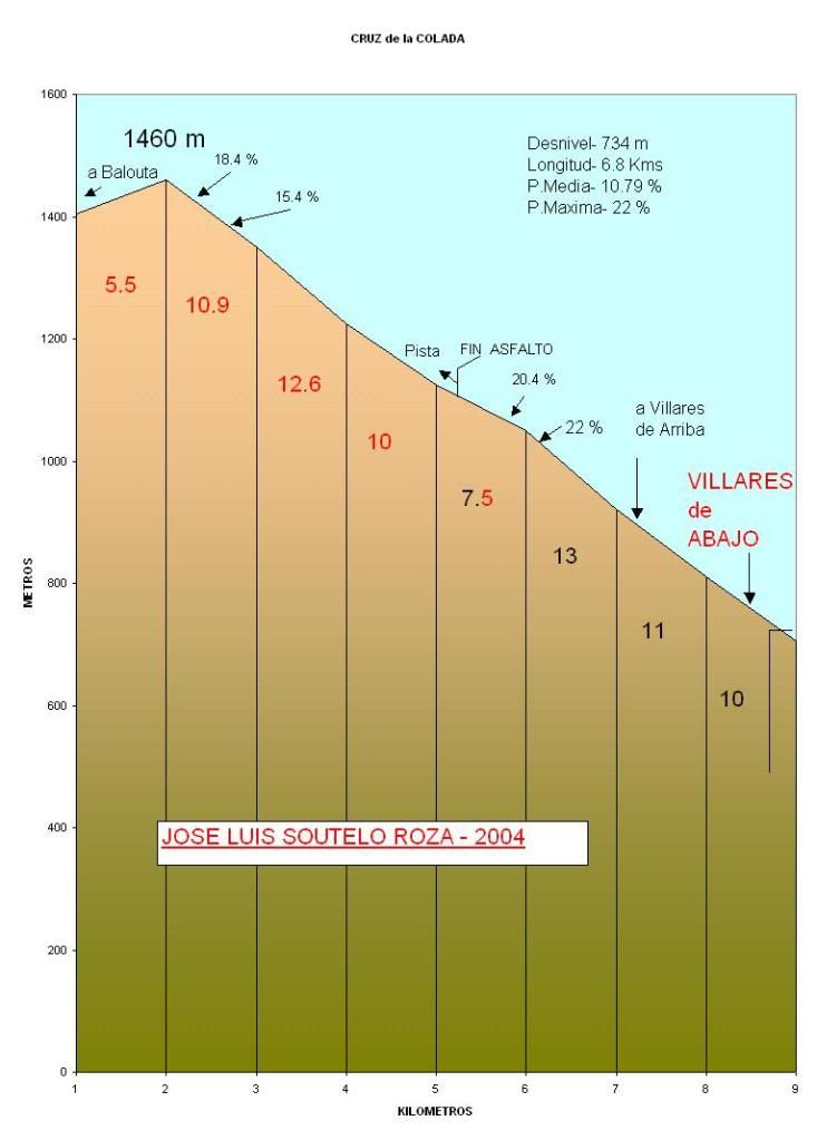
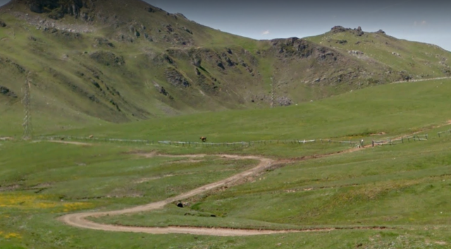
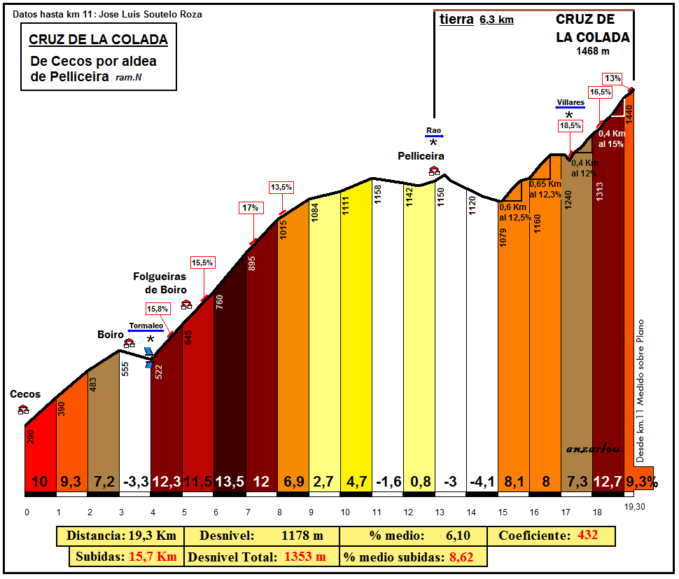
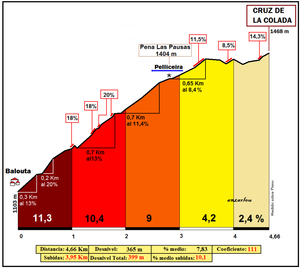
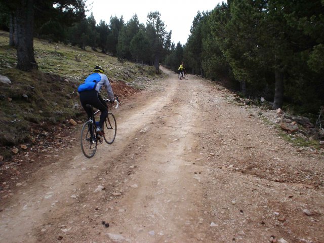
There are 2 sides of this climb, one from Cecos and one from Coro-Rio Baluta which share the last 2,6 km. (which is on gravel) But that is not to say Passo Pelliceira is a dead end road, since there is a road of 5,5 km from Passo Pelliceira to Cruz de Colada that is on gravel road.

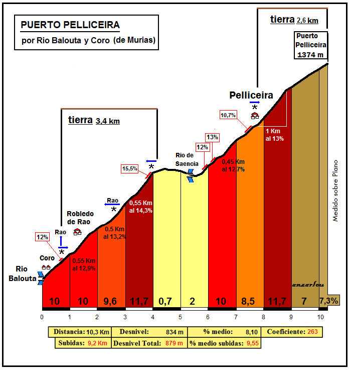
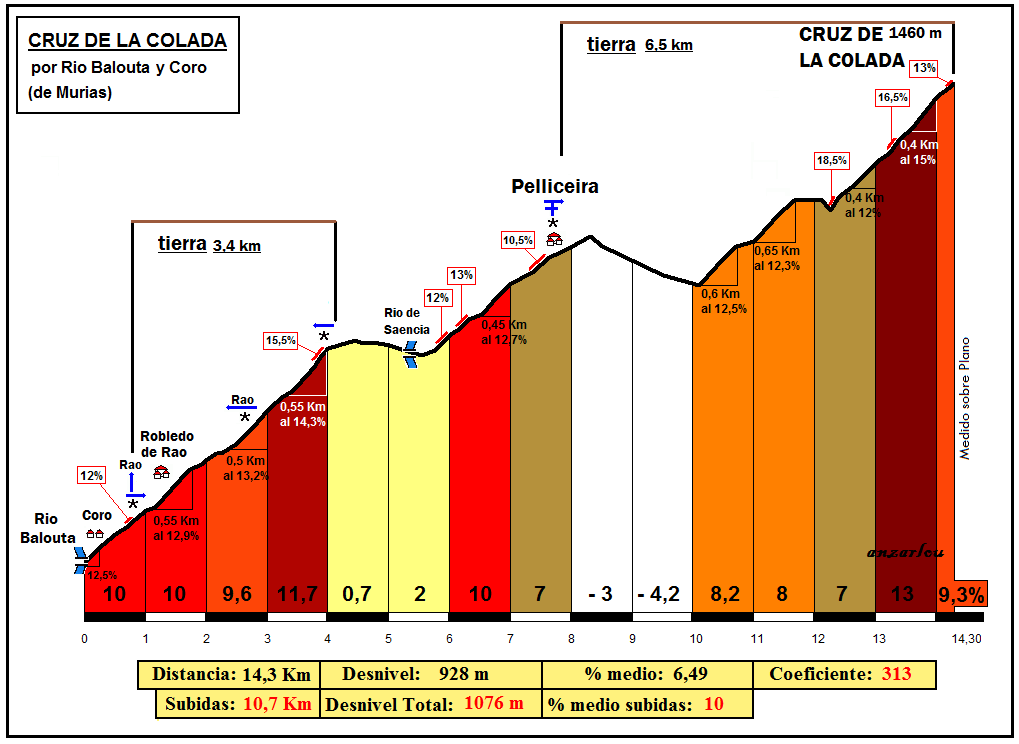
Passo Pelliceira por Coro-Rio Balouta. the overall stats for this climb is 10,3 km at %8,1 with a km of not steep descent. Also there is a 3,4 km of gravel road between km 0,5 and 4,5 so it rules out this side being used as a descend unless they asphalt the gravel part. The first 4 km of this climb averages %10,3 before a mixture of climbing and descending for 2 kms. Then, the next 4 km are at %9,3 before the last 300m at %7,3 as the last 2,6 km of this side (after the Pelliceira village) are the same as the Cecos side. The maximum gradient of this side of the climb is %15,5, at the 4th km.

PELLICEIRA_riobaloutacoro263-10.png


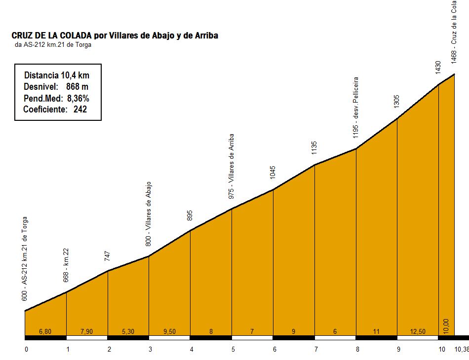
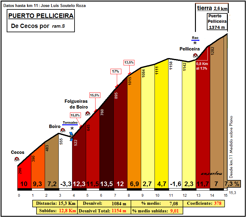
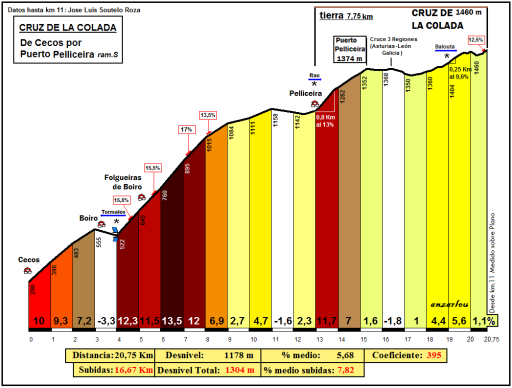
Passo Pelliceira por Cecos. The overall stats for this climb is 15,3 km at %7,1 but there is a descent part between km 3 and 4 (which averages %3,3) and there is a false flat descent and false flat ascent part between kms 11 and 13. The kms between 9 and 11 are also pretty easy at %3,7 so actually the stats don't tell the whole story. The first 3 km are %8,8. After the descent the next 4 kms average %12,3. The next km is at %6,9 before 2 kms at %3,7. Then, after the false flat descent-false flat ascent part of 1,7 kms we reach the village of Pelliceira and share the last 2,6 km with the Coro-Rio Balouta side which is on gravel. I don't know the gradients of the first 300 m. Then a km at %11,7, a km at %7 before the last 300m at %7,3. The maximum gradient of this side is %17.

PELLICEIRA_cecos378-15.png
 
In my earlier post I told you that there is a gravel road of 5,5 kms from Passo Pelliceira to Cruz de la Colada.
This 5,5 km of gravel road has changing gradients. first 1,7 km is a false flat descent. After we start climbing yet again. After a km of climbing at %1, there are 2 kms that average %5 with a 250m stretch at %9,6. The last 750m has both descent and climbing so it averages only %1,1.
The profile of Cruz de la Colada from Cecos-Passo Pelliceira:
colada_cecos-S-395-20.png


From Coro-Rio Balouta-Passo Pelliceira:
colada_riobaloutacoro3regiones280.png


Though there are also more different ways (though 2 of them become together at the village of Pelliceira) of approaching Cruz de la Colada:
The first one which is the Coro-Rio Balouta and the second one which is the Cecos side join at the village of Pelliceira but this time we will be going to Cruz de Colada from a different road which is gravel as well. After 300-400m of climbing (don't know the gradient though) there is a descent of 1600-1700 meters at around %4 or so. After the descent we start climbing the last 4,3 km to Cruz de Colada. The first km is %8,2 but with a stretch of 600m at %12,5. The second km is %8 with a stretch of 650 m at %12,3. The 3rd km has a little flat and descent part, then the road has a pitch of %18,6! And the last 400m of this km is %12. The next km is at %13 with 400m at %15! The last 300m are %9,3.

Cruz de la Colada from Coro-Rio Balouta:
colada_riobaloutacoro313.png


Cruz de la Colada from Cecos:
colada_cecos-432-19-190.png
 
Re:

Red Rick said:
Ik approve of this thread
Thanks Red Rick!
Here is the other side of Cruz de la Colada. It shares the first 13,5 km or so with the Balouta side of Ancares till Balouta and then the last 4,66 km to Cruz de la Colada from Balouta.
The first part of the climb (till Balouta) :
AncaresN.gif

And the second part of the climb:
COLADA_Balouta-111-466-97.png


Since the Balouta side of Ancares is knwon (and even used in a cycling race, let me describe the last 4,66 km which averages %7,83.(the 2nd part)
The first km is at %11,3 with 200m at %20! The 2nd km is at %10,4 with pitches of %18 and 20. The 3rd km is a bit easier at %9. Then the first 500m of the next 1km is at %8-9 or so with pitches of %11,5. Then the next 400-500m have a mixture of flat, descending and climbing. The last 660m have a mixture of flat, descending and climbing with pitches of %14. The last 4,66 km to Cruz de la Colada from this side may or may not be in the gravel. I couldn't find anything about it. The complete stats of Cruz de la Colada from this side is 17,5 km at %5,3.
 
There's also Trobaniello and Sahún which are traceur favourites that are only partially asphalted. And of course the Col de Parpaillon in France. And the Puerto de Vegarada is also quite well known, being parallel to San Isidro and leading into a potentially excellent finish at EE Riopinos. The south side of La Farrapona is fairly easy but mostly unpaved, could be a great finish after Trobaniello too.

None of those are as brutal as Pelliceira, I've seen it in a few course designs but steered clear thus far as I think some of the unpaved sections on both sides are too tough for a descent, rendering it difficult to justify from either direction in the Race Design Thread at present, but if some of those could be resolved in some way, it would make a brutal double with Ancáres (after all, you could descend the side via Balouta then climb via Pan do Zarco for a mega brutal combo). As opposed to, say, the Col du Lein which I think is perfectly passable as the descending on gravel would only account for a short and relatively wide open section.
 
Re:

Libertine Seguros said:
There's also Trobaniello and Sahún which are traceur favourites that are only partially asphalted. And of course the Col de Parpaillon in France. And the Puerto de Vegarada is also quite well known, being parallel to San Isidro and leading into a potentially excellent finish at EE Riopinos. The south side of La Farrapona is fairly easy but mostly unpaved, could be a great finish after Trobaniello too.

None of those are as brutal as Pelliceira, I've seen it in a few course designs but steered clear thus far as I think some of the unpaved sections on both sides are too tough for a descent, rendering it difficult to justify from either direction in the Race Design Thread at present, but if some of those could be resolved in some way, it would make a brutal double with Ancáres (after all, you could descend the side via Balouta then climb via Pan do Zarco for a mega brutal combo). As opposed to, say, the Col du Lein which I think is perfectly passable as the descending on gravel would only account for a short and relatively wide open section.
Trobaniello is like Finestre, the side which should be climbed is gravel and the flat sterrato part is less than 3,5 km and looks safe. I already used it on my 2nd Vuelta. Vegarada is similar too since the side that should be used is gravel, though the state of the road looks worse but I think it can be used and I already used it on my 3rd Vuelta with the finish in EE Riopinos. Other side of La Farrapona is another great pick since it can be used as a short but steep climb either after Trobaniello or after Ventana which are greatly connected with Cobertoria, San Lorenzo and Maravio. Then you can alternatively descend the side that is climbed to finish in Pola de Somiedo.

Parpaillon is unpaved on both sides so I don't think it will be used at any point in near future as a pass and it is pretty known. Also which side of Sahun is asphalted? The one from Plan or the one from Castejon de Sos or none?
 
Re:

TromleTromle said:
GREAT THREAD!

actually any one of the sides could serve well as a early Vuelta MTF

No need to put tarmac there!!!
Thanks a lot!
Pelliceira and Cruz de la Colada can serve as a MTF even with their current condition. Though knowing Guillen he will probably use Cruz de la Colada as a MTF from Balouta side of Ancares instead of a Pelliceira MTF or a Cruz de la Colada MTF via Pelliceira.
 
Tonton said:
http://forum.cyclingnews.com/viewtopic.php?p=2058988#p2058988

From my last TdF design, le Col des Glieres from the toughest side, never used in pro-cycling is a toughy. Just about one mile on the flatish top part, leading to a very technical descent...
Glieres is another one but the 2 km of sterrato looks okay from both sides and I think it can be used from both sides.
 
Re: Re:

Forever The Best said:
Trobaniello is like Finestre, the side which should be climbed is gravel and the flat sterrato part is less than 3,5 km and looks safe. I already used it on my 2nd Vuelta. Vegarada is similar too since the side that should be used is gravel, though the state of the road looks worse but I think it can be used and I already used it on my 3rd Vuelta with the finish in EE Riopinos. Other side of La Farrapona is another great pick since it can be used as a short but steep climb either after Trobaniello or after Ventana which are greatly connected with Cobertoria, San Lorenzo and Maravio. Then you can alternatively descend the side that is climbed to finish in Pola de Somiedo.

Parpaillon is unpaved on both sides so I don't think it will be used at any point in near future as a pass and it is pretty known. Also which side of Sahun is asphalted? The one from Plan or the one from Castejon de Sos or none?
I think the state of some parts of Vegarada makes it difficult, I mean it's not quite as untenable as Piedrafita (the one in Asturias, not the more famous one in León, close to the Puerto de las Gobernadas and Fonte da Cova) but still. Piedrafita is an off-shoot of the Vegarada road and it's preposterous.

On Sahún, both sides are partially asphalted, then have some sterrato and a stretch of hormigón at the summit.

PRC also like to use the north side of Rasos de Pegüera, which has some sterrato that links the Coll de Fumanyà with the ski station.

rasos-por-figols.png


This is the road, though, so it's borderline.

pista-rasos-2006-ramaca.jpg
 
But there are still a few more sides of Cruz de la Colada.
This starts from Luina (I think) and the overall stats of this part is 6,8 km at %10,8! The first km is %10, the second one %11 and the 3rd km is %13 with pitches of %22! The 4th km is %7,5 but there are pitches of %20,4! And the asphalt ends and gravel road starts in the final part of the 4th km. Then there are 3 kms of %11,1 with pitches of %115,4 and %18,4!
CRUZDELACOLADA_villaresdeabajo.jpg


There is still one more side though.
It starts between Torga and Villares de Abajo. The first 3 kms to Villares de Abajo are pretty easy at %6,67. It gets harder in the next 2 kms to Villares de Arriba which avregae %8,75. At the end of Villares de Arriba the asphalt finishes and the gravel road starts. The next 3 km are at %7,33. The next 2 km after the intersection of Pelliceira are %11,75. The last 380-400 meters are at %10. The overall stats of the climb from this side is 10,4 km at %8,36
X-242-10-113-COLADA_villares.png


Yes Pelliceira and Cruz de la Colada are over. Though there may be a post (or not) about potential stages.
 
Re: Re:

Libertine Seguros said:
Forever The Best said:
Trobaniello is like Finestre, the side which should be climbed is gravel and the flat sterrato part is less than 3,5 km and looks safe. I already used it on my 2nd Vuelta. Vegarada is similar too since the side that should be used is gravel, though the state of the road looks worse but I think it can be used and I already used it on my 3rd Vuelta with the finish in EE Riopinos. Other side of La Farrapona is another great pick since it can be used as a short but steep climb either after Trobaniello or after Ventana which are greatly connected with Cobertoria, San Lorenzo and Maravio. Then you can alternatively descend the side that is climbed to finish in Pola de Somiedo.

Parpaillon is unpaved on both sides so I don't think it will be used at any point in near future as a pass and it is pretty known. Also which side of Sahun is asphalted? The one from Plan or the one from Castejon de Sos or none?
I think the state of some parts of Vegarada makes it difficult, I mean it's not quite as untenable as Piedrafita (the one in Asturias, not the more famous one in León, close to the Puerto de las Gobernadas and Fonte da Cova) but still. Piedrafita is an off-shoot of the Vegarada road and it's preposterous.

On Sahún, both sides are partially asphalted, then have some sterrato and a stretch of hormigón at the summit.

PRC also like to use the north side of Rasos de Pegüera, which has some sterrato that links the Coll de Fumanyà with the ski station.

rasos-por-figols.png


This is the road, though, so it's borderline.

pista-rasos-2006-ramaca.jpg
Thanks for the info about Sahun. Rassos de Peguera is another one of those. Climbing it from the unconventional side via Coll de Fumanya and Col de Peguera and the final part to Rassos de Peguera on sterrato after a very short descent. From there the stage can finish at Coll de Pal, Berga, or even better at Santuari de Queralt, or climbing Sant Isidre then doing the Pradell-Fumanya combo to finish at Sant Julia de Cerdanyola. I also thought of designing a stage with climbing the conventional side of Rassos de Peguera then descending from the unconventional route with sterrato but after looking at the road I decided that the state of the gravel is not good enough to be used as a descent. It is good enough to be used as a climb though.


fauniera said:
Good thread. :)
Thanks a lot!
 
Another one in Asturias/León area which would be a great end to a stage stage is: first climb the criminally underused La Cubilla (by road), followed by rolling gravel section over the top to San Emiliano, and finish with a steep gravel climb up the 'wrong' side of the Farrapona (from Torrestio).

Wrong side of Farrapona below; the road surface generaly not too bad - not dissimilar to Finestre:

La%20Farrapona%20sur%20perfil.gif


Perhaps earlier in the day you could add in San Lorenzo, Cobertoria or maybe Cordal for a really interesting and tough stage.
 
Re:

DFA123 said:
Another one in Asturias/León area which would be a great end to a stage stage is: first climb the criminally underused La Cubilla (by road), followed by rolling gravel section over the top to San Emiliano, and finish with a steep gravel climb up the 'wrong' side of the Farrapona (from Torrestio).

Wrong side of Farrapona below; the road surface generaly not too bad - not dissimilar to Finestre:

La%20Farrapona%20sur%20perfil.gif


Perhaps earlier in the day you could add in San Lorenzo, Cobertoria or maybe Cordal for a really interesting and tough stage.
We talked about La Farrapona, but didn't post a profile. But the other side of Cubilla doesn't even look possible for climbing. It looks like a goat track.
 
Re: Re:

Forever The Best said:
DFA123 said:
Another one in Asturias/León area which would be a great end to a stage stage is: first climb the criminally underused La Cubilla (by road), followed by rolling gravel section over the top to San Emiliano, and finish with a steep gravel climb up the 'wrong' side of the Farrapona (from Torrestio).

Wrong side of Farrapona below; the road surface generaly not too bad - not dissimilar to Finestre:

La%20Farrapona%20sur%20perfil.gif


Perhaps earlier in the day you could add in San Lorenzo, Cobertoria or maybe Cordal for a really interesting and tough stage.
We talked about La Farrapona, but didn't post a profile. But the other side of Cubilla doesn't even look possible for climbing. It looks like a goat track.
The top bit of the Cubilla is fine, I rode it a few weeks ago on a road bike. It's regularly used by 4x4s and normal cars accessing the buildings in the mountains.

Cubilla%20sterratos%20cantabricus.jpg
 
Re: Re:

DFA123 said:
Forever The Best said:
DFA123 said:
Another one in Asturias/León area which would be a great end to a stage stage is: first climb the criminally underused La Cubilla (by road), followed by rolling gravel section over the top to San Emiliano, and finish with a steep gravel climb up the 'wrong' side of the Farrapona (from Torrestio).

Wrong side of Farrapona below; the road surface generaly not too bad - not dissimilar to Finestre:

La%20Farrapona%20sur%20perfil.gif


Perhaps earlier in the day you could add in San Lorenzo, Cobertoria or maybe Cordal for a really interesting and tough stage.
We talked about La Farrapona, but didn't post a profile. But the other side of Cubilla doesn't even look possible for climbing. It looks like a goat track.
The top bit of the Cubilla is fine, I rode it a few weeks ago on a road bike. It's regularly used by 4x4s and normal cars accessing the buildings in the mountains.

Cubilla%20sterratos%20cantabricus.jpg
Woah, the state of the road looks great. Though when I looked to the bottom bit (I looked to the last place the google maps can go along the route on the way from San Emiliano to Cubilla) and when the Google maps ended the road looked like a goat track.
 
Re: Re:

Forever The Best said:
Woah, the state of the road looks great. Though when I looked to the bottom bit (I looked to the last place the google maps can go along the route on the way from San Emiliano to Cubilla) and when the Google maps ended the road looked like a goat track.
That's strange, maybe Google haven't updated it for a while, or the photos were taken in winter or just after there was snow. This is the start from where the road ends at the farmhouse just after the Cubilla:

cubilla.png


It's not perfect by any means, but it's easily passable on a road bike - certainly a lot better than Monte Crostis, which I did for the first time this summer and was surprised by how rough the first 2km of the gravel section is. With a bit of preparation and maintenance in preparation for a bike race it would be great - and the off-road section doesn't last too long anyway.
 
Re: Re:

DFA123 said:
Forever The Best said:
Woah, the state of the road looks great. Though when I looked to the bottom bit (I looked to the last place the google maps can go along the route on the way from San Emiliano to Cubilla) and when the Google maps ended the road looked like a goat track.
That's strange, maybe Google haven't updated it for a while, or the photos were taken in winter or just after there was snow. This is the start from where the road ends at the farmhouse just after the Cubilla:

cubilla.png


It's not perfect by any means, but it's easily passable on a road bike - certainly a lot better than Monte Crostis, which I did for the first time this summer and was surprised by how rough the first 2km of the gravel section is. With a bit of preparation and maintenance in preparation for a bike race it would be great - and the off-road section doesn't last too long anyway.
The top part looked fine, I was talking about the bottom part. If they asphalt the bottom part then it can be climbed from that San Emiliano side as well because the top part looks fine for climbing.
 
Re: Re:

Forever The Best said:
DFA123 said:
Forever The Best said:
Woah, the state of the road looks great. Though when I looked to the bottom bit (I looked to the last place the google maps can go along the route on the way from San Emiliano to Cubilla) and when the Google maps ended the road looked like a goat track.
That's strange, maybe Google haven't updated it for a while, or the photos were taken in winter or just after there was snow. This is the start from where the road ends at the farmhouse just after the Cubilla:

cubilla.png


It's not perfect by any means, but it's easily passable on a road bike - certainly a lot better than Monte Crostis, which I did for the first time this summer and was surprised by how rough the first 2km of the gravel section is. With a bit of preparation and maintenance in preparation for a bike race it would be great - and the off-road section doesn't last too long anyway.
The top part looked fine, I was talking about the bottom part. If they asphalt the bottom part then it can be climbed from that San Emiliano side as well because the top part looks fine for climbing.

Oh right, I see the bit you mean on Google - where the streetview finishes in the middle of Pinos. I think it makes it looks way worse than it is. I can imagine after rain, that short section through the rest of the village, it gets slightly churned up because of all the cars on it, but 50m after where google ends, you take a right fork and the trail is fine again - mostly compacted dirt with a small amount of loose gravel on top - and the surface is very solid for riding if you stick to the lines that the tyre tracks have made.
 
Re: Re:

DFA123 said:
Forever The Best said:
DFA123 said:
Forever The Best said:
Woah, the state of the road looks great. Though when I looked to the bottom bit (I looked to the last place the google maps can go along the route on the way from San Emiliano to Cubilla) and when the Google maps ended the road looked like a goat track.
That's strange, maybe Google haven't updated it for a while, or the photos were taken in winter or just after there was snow. This is the start from where the road ends at the farmhouse just after the Cubilla:

cubilla.png


It's not perfect by any means, but it's easily passable on a road bike - certainly a lot better than Monte Crostis, which I did for the first time this summer and was surprised by how rough the first 2km of the gravel section is. With a bit of preparation and maintenance in preparation for a bike race it would be great - and the off-road section doesn't last too long anyway.
The top part looked fine, I was talking about the bottom part. If they asphalt the bottom part then it can be climbed from that San Emiliano side as well because the top part looks fine for climbing.

Oh right, I see the bit you mean on Google - where the streetview finishes in the middle of Pinos. I think it makes it looks way worse than it is. I can imagine after rain, that short section through the rest of the village, it gets slightly churned up because of all the cars on it, but 50m after where google ends, you take a right fork and the trail is fine again - mostly compacted dirt with a small amount of loose gravel on top - and the surface is very solid for riding if you stick to the lines that the tyre tracks have made.
Ah, thanks for the info. It looks usable then. Also, accidentally I looked at this place which isn't on the main road (it is the start of a different road after the left turn-while the Cubilla one goes straight) and made the goat track claim after seeing this:
https://www.google.com/maps/@42.983...4!1sVfST8xN7udZgJqW810nbtQ!2e0!7i13312!8i6656
 
Yeah, it's definitely useable in theory, but whether the Vuelta or the big Asturian/Leonese races would include a climb like that as a pass well before the end of the stage is pretty unlikely I think for the forseeable future. It's such a shame though - Cubilla is definitely one of the most scenic and enjoyable climbs in the whole of Spain, even if it's too easy to be really selective. But it's never going to be used as a mtf probably, because it's too far from any reasonable sized town and nearby ski resorts like Cuitu Negru are much more likely to stump up the money required.
 

TRENDING THREADS