
Great "unknown" climbs
Page 4 - Get up to date with the latest news, scores & standings from the Cycling News Community.
You are using an out of date browser. It may not display this or other websites correctly.
You should upgrade or use an alternative browser.
You should upgrade or use an alternative browser.

- May 12, 2011
- 241
- 0
- 0
El Pistolero said:Waipio Valley Road
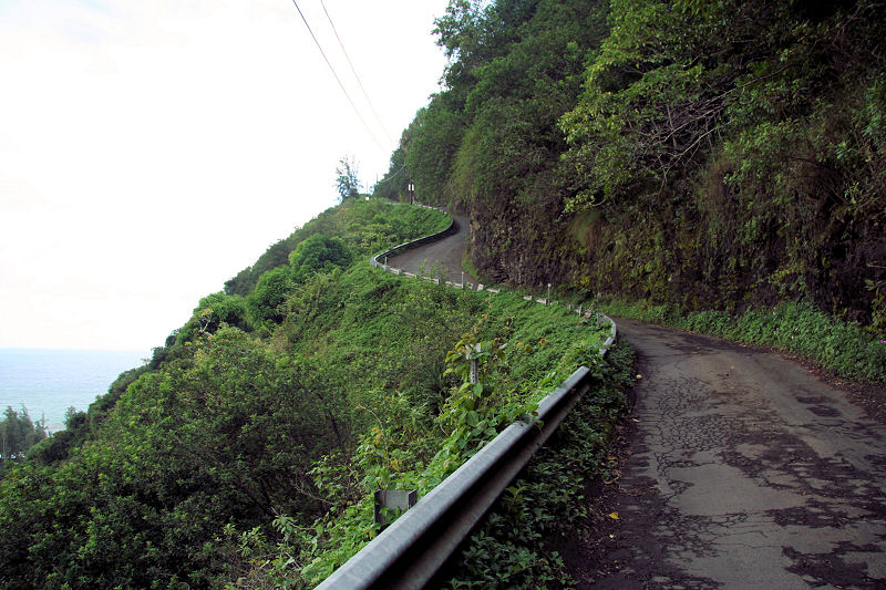
1km long with an average grade of 25% and maximum grade of 40%
I was coming to post that. I know that they don't allow anything but 4 wheel drive vehicles and no rental cars. It took Lance 9 minutes to ride the .6 miles for charity.
jsem94 said:Lol, I knew Scanuppia would get a mention in this thread - it's the steepest crap in the world.
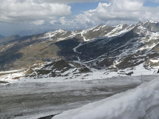
Norway though is a country which is like 90% mountain, but few roads actually go anywhere up these mountains. There is one ski resort only open on summers though, that I was fortunate enough to drive down from after having climbed Galdhöpiggen (Norway's highest peak). It looks something like this:
By far the toughest climb in Scandinavia. Which is a shame, lol.
Spent way to much time looking at maps and finding climbs, then formulating a massive reply. Gah, needless to say the post went down the ****ter. So I'm just going to post up some of the climbs I found in Norway, no doubt dwarfed by some of the climbs in this world. Still it would be nice to see some racing on them, Tour of Norway perhaps.
First up are the connectable mountains, passes etc.
Telemark
Dalen - Nord
ELE 100M-700M DIST 7,0KM GRA 8,5%
Dalen - Sør
ELE 100M-790M DIST 11,5KM GRA 6,0%
Sogn og Fjordane
Erdal - FV 243
ELE 20M-1220M DIST 15,4KM GRA 7,7%
Aurland - FV 243
ELE 20M-1300M DIST 15,6KM GRA 8,2%
Fortun - Sognefjell - RV 55
ELE 40M-1420M DIST 26,4KM GRA 5,2%
ELE 40M-1400M DIST 25,8KM GRA 5,2%
ELE 40M-1300M DIST 17,1KM GRA 7,3%
ELE 40M-1200M DIST 14,2KM GRA 8,1%
Øvre Årdal - Tyin - RV 53
ELE 20M-1100M DIST 21,1KM GRA 5,1%
Øvre Årdal - Berdalsbandet - RV 302
ELE 20M-1320M DIST 18,7KM GRA 6,9%
Møre og Romsdal
Geiranger Nord - RV 63
ELE 20M-640M DIST 6,9KM GRA 8,9%
Geiranger Sør - RV 63
ELE 20M-1020M DIST 14,6KM GRA 6,8%
Oppland
Ringebu
ELE 200M-960M DIST 10,9KM GRA 6,9%
Then a couple roads that end on the top, most with atleast some gravel.
Osa - Austdølvatnet
ELE 20M-940M DIST 8,4KM GRA 10,9%
Geiranger - Dalsnippen - RV 63 - Grus
ELE 20M-1440M DIST 20,2KM GRA 7,0%
Ljøsne, Lærdal Kommune - Mot Kvevasshytta
ELE 80M-1440M DIST 18,3KM GRA 7,4%
Rjukan
ELE 260M-1260M DIST 13,6KM GRA 7,3%
Sæbø, Eidfjord - Berastøldalen
ELE 20M-860M DIST 8,8KM GRA 9,5%
And a couple of unfeasable ones.
Øvre Årdal - Toppen - RV 53 - Grus
ELE 20M-1000M DIST 11,3KM GRA 8,6%
Høyanger - Bergsvatnet
ELE 20M-700M DIST 7,4KM GRA 9,1%
Vågå - Blåhøi
ELE 400M-1600M DIST 14,5KM GRA 8,2%
Nordberg, Skjåk Kommune - Aursjøen - Rute 1
ELE 420M-1140M DIST 8,1KM GRA 8,8%
Nordberg, Skjåk Kommune - Aursjøen - Rute 2
ELE 420M-1140M DIST 7,3KM GRA 9,8%
Alvdal - Tronfjell
ELE 500M-1660M DIST 11,0KM GRA 10,5%
Os - Håmmålsfjellet
ELE 620M-1540M DIST 10,6KM GRA 8,6%
I think that's it, might have forgotten about a couple. No images, sorry.
- May 4, 2011
- 4,301
- 798
- 17,680


- Feb 20, 2010
- 33,270
- 15,822
- 28,180
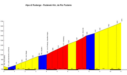
Alpe di Rodengo, Italy (11,2km, 8,8%):
Starting in Rio di Pusteria, the toughest part of this climb is in the middle:
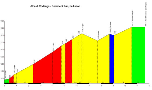
It can be used as a pass, descending down into Luson - or of course climbed from that side. This side is shorter and less steep, mainly due to some short descent and false flat; there are still huge, steep walls and in fact it might make a better MTF if climbed from that side:
There's not a great deal to link it to directly, but the Rio di Pusteria side could be attached to the Sella di Sharter (9,8km, 9,0%) from Vallarga with a bit of repaving, plus the Sergser Straße into Meransen could make for a decent warmup.
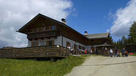
You have several XC ski tracks around there, for which the Roner Hütte serves as a base, and therefore a feasible stage finish:
And here's a view of what you are going to be climbing:

Starting in Rio di Pusteria, the toughest part of this climb is in the middle:
It can be used as a pass, descending down into Luson - or of course climbed from that side. This side is shorter and less steep, mainly due to some short descent and false flat; there are still huge, steep walls and in fact it might make a better MTF if climbed from that side:
There's not a great deal to link it to directly, but the Rio di Pusteria side could be attached to the Sella di Sharter (9,8km, 9,0%) from Vallarga with a bit of repaving, plus the Sergser Straße into Meransen could make for a decent warmup.
You have several XC ski tracks around there, for which the Roner Hütte serves as a base, and therefore a feasible stage finish:
And here's a view of what you are going to be climbing:
As far as the climbs on the Canary Islands go, nothing on Tenerife is very steep except for the climb out of Masca that has a short section of 20%, but overall that climb isn't very long. There are four roads up Teide all are about a 2000m climb, but again not very steep(5-8%, mostly in the 5-6%) just long.
There are a couple of tough climbs in the Canaries. Pozo de Las Nieves from Telde on Gran Canaria is very difficult. It is a 1900m climb to the summit with a lot of it at 10%+.
On Las Palmas there is El Roque de Los Muchachos. It isn't really steep at 6-8%, but it is very long. From Santa Cruz it is about a 2500m climb.
Regarding the Col du Sanetsch in Switzerland, that tunnel about 3km from the top is nasty. It is unlit, and when I rode it there was some really ugly mud flowing inside that gunked up my bike big time.
- Apr 14, 2011
- 998
- 0
- 0
This is where it leads to :http://www.lagirada.com/mantet_eng.htmLupetto said:Col de Mantet looks great. The eastern Pyrénées are filled with great roads, made for cycling.
Apparently it's in a nature reserve, so they probably wouldn't want the Tour going up there. Maybe a smaller race like Route du Sud?
- May 29, 2011
- 20
- 0
- 0
icefire said:There is a 'better' alternative for the first 30 kms of the climb to Mt Veleta that has never been used in a pro race:
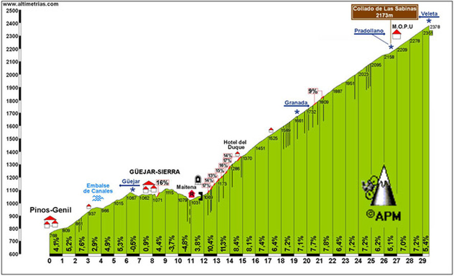
Only the section from km 19 to km 26 was included in the 2009 Vuelta.
Even in the race wouldn't enter the National Park protected area above 2500m it's still a monster c.mb.
Pico Veleta is harder over Monachil/El Purche. El Purche is fierce in it's own right. I have also been up to Pico Veleta, road bike, September, 2010. There is several 14%'s and some over 20%'s over El Purche.
- Feb 20, 2010
- 33,270
- 15,822
- 28,180
The Col du Mantet could easily be linked to the Col de Jau from its harder side (13,4km, 6,7%):
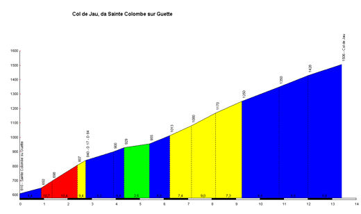
That descends right down to Prades, and it's not far from there to the base of Mantet; though you could always stick the Col de Vernet (not very steep but final 2km at about 8%) or the Col de Fins (roughly 9km @ 4,5%) in then descend to Sahorre and do the rest of the Mantet climb.
That descends right down to Prades, and it's not far from there to the base of Mantet; though you could always stick the Col de Vernet (not very steep but final 2km at about 8%) or the Col de Fins (roughly 9km @ 4,5%) in then descend to Sahorre and do the rest of the Mantet climb.

- Feb 20, 2010
- 33,270
- 15,822
- 28,180
Errozate (10,1km, 9,6%)
There are two ways up this; the steeper one as mentioned above:

And the less steep route, also from Esterençuby:

Well, actually, there are other ways, but these would be the main ones.
There isn't a lot in the area, it's very exposed, and there is practically nothing at the summit:

Perhaps the best thing to do would be descend back down from it at the Col d'Artaburu, running flat to the Burdincurutcheta and descending; or a selection of short climbs and descends placing a finish at Les Chalets d'Irati or the Col d'Hegichouria, or even descending back down from there and climbing the Port de Larrau.
Either way, Errozate must be in.
There are two ways up this; the steeper one as mentioned above:
And the less steep route, also from Esterençuby:
Well, actually, there are other ways, but these would be the main ones.
There isn't a lot in the area, it's very exposed, and there is practically nothing at the summit:
Perhaps the best thing to do would be descend back down from it at the Col d'Artaburu, running flat to the Burdincurutcheta and descending; or a selection of short climbs and descends placing a finish at Les Chalets d'Irati or the Col d'Hegichouria, or even descending back down from there and climbing the Port de Larrau.
Either way, Errozate must be in.
With regards to the Veleta, also known as Sierra Nevada or Pico Veleta, the Vuelta only goes partway up this huge climb. Depending on the year, they stop at either 2100m(ski station), 2300m or 2500m. However, the road continues paved all the way to 3300m. The last 1km to the top of Pico Veleta (3400m) is pretty steep dirt(12%), but the Vuelta could go up to 3300m and make it a 9000' (2700m) climb if they so desired.
It would be epic!
It would be epic!
- May 15, 2010
- 1,286
- 34
- 10,530
Yep, it's a nice climb. There are a couple of potentially great climbs here, but the tarmac is in bad condition.Libertine Seguros said:Again, the point of this thread is to highlight climbs that COULD be used in a race. I know theoretically Scanuppia and that could be used, but realistically it's an impossibility.
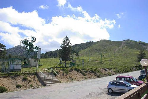
Now, to draw a bit of inspiration from one of my other sporting loves - the Nordic skiing disciplines, especially biathlon - here's the climb of Shiligarnika from Bansko, Bulgaria to the Banderica Ski Station and Biathlon Center (10,8km, 7,0%).

The climb from a suburb of Sofia to the Aleko hut.
http://climbbybike.com/profile.asp?Climbprofile=Aleko-Vitosha&MountainID=112
It looks easy, but there is a catch.
The whole climb is cobbled.

edit: FFS the stupid forum isn't showing the picture.
- Sep 8, 2010
- 1,441
- 0
- 0
Duartista said:This is where it leads to :http://www.lagirada.com/mantet_eng.htm
Apparently it's in a nature reserve, so they probably wouldn't want the Tour going up there. Maybe a smaller race like Route du Sud?
For Route du Sud it could be a perfect climb.
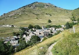
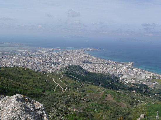
Erice, Italy. 10 km, 7,4%.

Erice is a small mountain town in la Provincia di Trapani. From there you have a stunning view on the ocean. It would be perfect for a little race in Sicilia or even as a first mountain test in the Giro. The last meters in the town are cobbled.
There are a lot of these towns in Sicilia.
no crostis said:Pico Veleta is harder over Monachil/El Purche. El Purche is fierce in it's own right. I have also been up to Pico Veleta, road bike, September, 2010. There is several 14%'s and some over 20%'s over El Purche.
You're right, but El Purche is not unknown. At least not to Valverde who lost the 2006 Vuelta descending it. Neither to Evans for his incident with the neutral service in 2009
- Feb 20, 2010
- 33,270
- 15,822
- 28,180
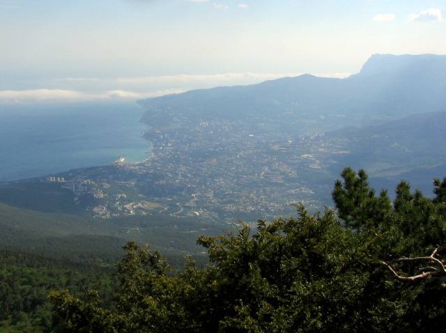
Nikitskiy Pereval, Ukraine (19km, 6,3%).
Starting in Yalta, this Crimean climb features some pretty horrendous quality roads.

There are different starting routes, ranging from 19km to 25km, though the main body of the climb is the same:

The view down on the city of Yalta is pretty nice too:
Starting in Yalta, this Crimean climb features some pretty horrendous quality roads.
There are different starting routes, ranging from 19km to 25km, though the main body of the climb is the same:
The view down on the city of Yalta is pretty nice too:


- May 4, 2011
- 4,301
- 798
- 17,680
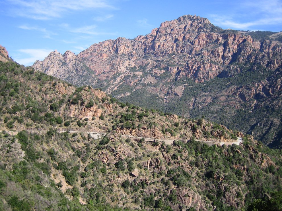
Port de Boucharo / Puerto de Bujaruelo (2270m), central Pyrenees, France
The road terminates on the Spanish border, but needs some work. The scenery is stunning (Cirque de Gavarnie) and the road itself is popular among tourists, but remains unused by the TDF.
This climb cannot be directly linked to another big climb, unless you include the 20 kilometer long stretch of mostly false flat between Luz-St-Sauveur (Tourmalet) and Gavarnie.......


http://www.climbbybike.com/profile.asp?Climbprofile=Port-de-Boucharo&MountainID=7058
The road terminates on the Spanish border, but needs some work. The scenery is stunning (Cirque de Gavarnie) and the road itself is popular among tourists, but remains unused by the TDF.
This climb cannot be directly linked to another big climb, unless you include the 20 kilometer long stretch of mostly false flat between Luz-St-Sauveur (Tourmalet) and Gavarnie.......
http://www.climbbybike.com/profile.asp?Climbprofile=Port-de-Boucharo&MountainID=7058
Veleta/mulhacen/sierra nevada.
1300 racers did it this month, but not a single one to report here?
They also race up on foot on a separate day.
This year there is still snow at the top
What I would love to read are details on the road from sea-level in Motril, looks doable on the map.
http://www.ideal.es/almeria/2011070...clistas-toman-salida-sierra-201107091148.html
Many of the climbs mentionned in this thread are actually well known, but it's interesting nonetheless.
I am surprised nobody, unless I missed it , reported the road that goes past Alpe d'Huez, past the club med and onto the Col de Sarenne at 1999 meters. The cyclosportive "La Vaujany" goes through it every year since 2002 or so. Marmottes (groundhogs) sure love that area.
CONCERNING SANETSCH : one day, a few years ago, intending to climb it I fitted a light on my racing bike , only to discover that the tunnel is now lit.
The Womble said:....
I'm not sure if this has been done recently, but if the Vuelta could do the climb to Sierra Navada and then continue to the end of the road. At 3400m.
I did it on a mountain bike last year and i remember the last bit being gravel and a bit rough but it would be possible to get up towards 3300m without a problem

1300 racers did it this month, but not a single one to report here?
They also race up on foot on a separate day.
This year there is still snow at the top
What I would love to read are details on the road from sea-level in Motril, looks doable on the map.
http://www.ideal.es/almeria/2011070...clistas-toman-salida-sierra-201107091148.html
Many of the climbs mentionned in this thread are actually well known, but it's interesting nonetheless.
I am surprised nobody, unless I missed it , reported the road that goes past Alpe d'Huez, past the club med and onto the Col de Sarenne at 1999 meters. The cyclosportive "La Vaujany" goes through it every year since 2002 or so. Marmottes (groundhogs) sure love that area.
CONCERNING SANETSCH : one day, a few years ago, intending to climb it I fitted a light on my racing bike , only to discover that the tunnel is now lit.
I would be interested in knowing when the lights were installed in the tunnel on the Col du Sanetsch. I rode it in July 2009 and there were no lights.
Good call on the Port du Boucharo. However, unless somebody removes the big boulders at the Col de Tentes you could only probably race to 2215m and not all the way to 2270m.
Another interesting summit finish would be to go right about 8km up the Pla d'Adet climb and ascend the Col du Portet which tops out at 2215m, 600m higher then Pla d'Adet. The road is OK with several short gravel sections.
rzombie1988
BANNED
- Jul 19, 2009
- 402
- 8
- 9,295
I don't know if this is appropriate, but:
Are there any cobblestone mountains out there? Or cobblestone hills like the ones in the Tour of Flanders? I'd really love love to see a cobblestone mountain race.
Are there any cobblestone mountains out there? Or cobblestone hills like the ones in the Tour of Flanders? I'd really love love to see a cobblestone mountain race.
- Jul 16, 2010
- 17,455
- 5
- 0
Libertine Seguros said:Again, the point of this thread is to highlight climbs that COULD be used in a race. I know theoretically Scanuppia and that could be used, but realistically it's an impossibility.
Armstrong has raced up it actually
- Jul 17, 2009
- 4,316
- 2
- 0
Libertine Seguros said:Continuing on from the above, I couldn't resist posting this pic from the Portal do Inferno, on the Serra da Erada, other side of São Macário:
My gps says "make a legal U-Turn". bring back the Triple
- May 6, 2009
- 8,522
- 1
- 0
18-Valve. (pithy) said:Col de Mantet, Eastern Pyrenees
<sniped>
Is that a MTF or a mountain pass, or could be used for both?
Here is Mount Wellington in Tasmania, it could be used in the Tour of Tasmania:

Average: 5.9 %
Length: 21.4 km
Maximum: 8.1 %
Description:
The last half of the climb is grueling especially "The Face" this is where people lose huge chunks of time.Mt wellingtons surface is suspect which makes it even harder.
http://www.climbbybike.com/climb.asp?Col=Mt-Wellington&qryMountainID=9717#profile
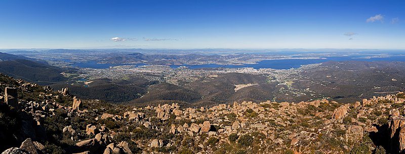
That's Hobart (capital of Tasmania for those playing at home) in the background, although it's hard to see.
BTW, for the Australian/Victorian posters, Mt Buller has been used in the Herald Sun Tour right? I know it's used in a few cyclo-sportives and whilst it isn't that steep, it's just one big drag to the top, not sure on the distance though (I haven't actually been to Mt Buller either).
TRENDING THREADS
-
 Liège - Bastogne - Liège 2026, one-day monument, 26th April
- Started by Krzysztof_O
- Replies: 2K
-
 Tour de Romandie neither one-day nor monument, 28/04-03/05 2026
- Started by QueenStagiaire
- Replies: 612
-
 Paris-Roubaix 2026, one day monument, April 12
- Started by Lequack
- Replies: 2K
-
 Itzulia Basque Country 2026, April 6-11
- Started by Dazed and Confused
- Replies: 2K
-
 Ronde van Vlaanderen 2026, monument, April 5 (men's)
- Started by Krzysztof_O
- Replies: 1K
-
 Teams & Riders The Remco Evenepoel is the next Eddy Merckx thread
- Started by DNP-Old
- Replies: 40K
-
 Teams & Riders Tadej Pogačar discussion thread
- Started by Lequack
- Replies: 44K


Cyclingnews is part of Future plc, an international media group and leading digital publisher. Visit our corporate site.
© Future Publishing Limited Quay House, The Ambury, Bath BA1 1UA. All rights reserved. England and Wales company registration number 2008885.