Race Design Thread

Page 244 - Get up to date with the latest news, scores & standings from the Cycling News Community.
Re:

OlavEH said:
I have been working on a Vuelta the last couple of weeks, but right now there are so many versions of the Vuelta being posted, that I think I'll change my focus to a TDS or TDF.

Btw; concerning a version of the Vuelta. Are there any good areas in Spain for long hilly/medium mountain stages except Basque Country?
Cantabria gives plenty of options with mid-sized climbs like Alisas, Hoz, Ozalba, Carmona, Braguía, Caracol and Brenes, short steep beasts like La Estranguada, longer and more gradual climbs like Palombera, La Sia, Asón, Estacas de Trueba, Los Tornos, Lunada and San Glorio, a steeper Vuelta classic in Escudo, and small to medium sized MTF possibilities at Cueva El Soplao, Peña Cabarga, Fuente Dé, and a longer more gradual summit in Fuente del Chivo.

The coastal parts of Galicia offer plenty of options, whether it be climbs like Monte Xiabre and Monte A Fracha around Pontevedra, Monte Aloia and Monte A Groba near the Portuguese border, the climbs like Garita de Herbeira in the northwestern corner or the Serra do Xistral (I love the Alto de Onsolár) and the area around A Pontenova (I used this in this stage from my 5th Vuelta, probably my favourite that I've designed, as it was all designed around the medium mountain stages being the queen stages).

Comunidad Valenciana has been used for many medium mountain stages in the past and is in vogue with the Vuelta. In addition to the recent short steep beast discoveries like Mas de la Costa and Cumbre del Sol (plus the older discoveries in a similar vein like Xorret del Catí) they also have the Alt del Miserat, and the Alt del Garbí, a traceur favourite near Sagunt. There are lots of cat.2 and cat.3 type climbs around, I like the Mirador del Xap climb, but there's also the Alt del Portillol near Ontinyent, which has a very steep first half called the Alt del Campillo, which used to host a Mende-style MTF in the Vuelta al Comunidad Valenciana before it went under (was recently resurrected).

The mountains near Jaén also offer options, though the Vuelta tends to just stop at La Pandera. In the same Vuelta as the Galician stage I linked above I had a stage which included the monstrously inconsistent side of Los Frailes which is arguable cat.1 despite being less than 8km at 5,6%, but there's also the Puerto Viejo, Puerto del Castillo, Puerto de Locubín, Puerto de Jamilena, and the Alto de Allanadas del Santo, which Froome beat Contador on in the Ruta del Sol in 2015 and I had included in a different Vuelta that I abandoned and cannibalized for this one (though I liked the stage so it will likely resurface at some point). If you approach from the south there's plenty of climbs like the Alto de Moclín, the Puerto de Granada and the Alto de Montefrío to add early stage difficulties too.

And then for a different type of medium mountain stage you have the Sierra de Gredos around Ávila and the Catalonian foothills, where there are plenty of climbs that are longer and more drawn out, but more consistent and at lesser gradients than those in places like Asturias so less likely to be selective, which can be used to create a nice medium mountain stage. Further west you have the climbs in the Sistema Central between Ciudad Rodrigo and Coria in the western parts of Salamanca and Extremadura - no big steep climbs, but plenty of low gradient mid length ones.
 
Jun 11, 2014
304
0
0
Counterclockwise Vuelta II

13. 54,4 km Tarragona-Sitges - ITT


jsbe7y1.png

Stage description:The only indivudual ITT in this race.
Wind is a factor as they race in parallel to the sea in northeastern direction.
By putting the ITT before the mountain - the dieselengines must invest hugely in this one to build up a lead - because there will be lots of opportunities for the climbers to attack the rest of the way to Madrid.

(short description as I am bit bit tied up elsewhere - but can't leave this Vuelta aside)
zO3YTca.png


Elevation Gain/Loss in m: 218/237
Mountains/hills: 0 (0 categorized)

Other considerations:

1. stage 169,5 km Huelva-Sevilla: Flat
2. stage 46,5 km Jerez-Cadiz: TTT
3. stage 192,1 km Vejar de la Frontera-Ronda: Medium Mountains
4. stage 150,8 km Ronda-Antequera: Flat
5. stage 158,5 km Antequera-Motril: Flat
6. stage 129,8 km Motril-Puerto de Ragua: Mountain - MTF
7. stage 200,6 km Granada-Cordoba: Flat
8. stage 129,8 km Bujalance-Sierra de la Pandera: Mountain - MTF
9. stage 194,6 km Guadix-Almeria: Medium Mountain
---Restday---
10. stage 144,6 km Cuenca-Teruel: Flat
11. stage 179,7 km Teruel-Escucha: Medium Mountain
12. stage 185,0 km Alcaniz-Tarragona: Flat
 
Stage 17: Vitória-Gasteiz - Peñas de Itxina (Alto de Pagomakurre), 149km

e5g31t.png


znm25z.png


GPM:
Alto de Kanpazar (cat.3) 4,4km @ 5,7%
Alto de Ixua (cat.2) 5,2km @ 7,8%
Monte Oiz (cat.1) 6,4km @ 9,4%
Puerto de Urkiola (cat.1) 5,7km @ 9,2%
Alto de Pagomakurre (cat.1) 9,0km @ 8,2%

Straight off the back of the big, monster time trial we have a short and fast mountain stage which is a real potential banana skin, not least because the climbers should have lost time by the truckload yesterday and so fireworks will be needed. And we're in the terrain which is most troublesome for the power climber - the inconsistent, painful ramps, narrow roads and rainy surfaces of Euskal Herria.

The stage takes in all three provinces of País Vasco. Bizkaia and Gipuzkoa are best known by their Basque names, but the southernmost, inland province is generally speaking the least nationalist and is widely known by its Castilian name, Álava - although the Basque equivalent, Araba, has a similar level of currency. The only stage in Euskadi proper (of course, stages 15 and 16 take place at least partially in lands claimed by Basques, but this is the only one taking place entirely within the boundaries of present day País Vasco), this one is a mixture of classic cycling - and Vuelta - tradition, and innovation, for there is still surprisingly a lot that racing has yet to really discover within this well-trodden land. País Vasco is one of Spanish cycling's main cradles; the Basque-Navarrese amateur scene is arguably the most competitive such scene in the country and has brought countless talents to the top ranks - not just the Basques and Navarrese, who obviously proliferate in the scene, but many riders from further afield have made it to the top via Basque amateur teams, such as Alberto Contador, Joaquím Rodríguez, Xavier Florencio, Samuel Sánchez and Juan José Cobo. Although the Volta a Catalunya is the oldest extant stage race in Spain, several of the oldest Spanish races are Basque, with the GP Excelsior, which became the Vuelta al País Vasco, being first held in 1924 - although of course from the Civil War until the late 60s the race did not run, there were substitute races such as the Circuito del Norte (running from 1939 to 1945, taking place in País Vasco with incursions into Navarra and Cantabria) and the slightly smaller scale GP Ayuntamiento de Bilbao which ran from 1943 as a short stage race around Bizkaia until the late 50s, then after a few years' absence continued as a one-day race in the early 60s. Alongside this, the Bicicleta Eibarresa was set up in 1952, as a stage race companion piece to the much-loved Subida a Arrate one-day race - subsequent mergers and developments made this into the Euskal Bizikleta which of course merged with the Itzulia in recent years. In the one-day sphere, we pay tribute to two of the greatest of the classic Spanish climbing one-dayers, as well. The Bicicleta Eibarresa itself came from the same cloth as the Vuelta itself, since the Eibar-Madrid-Eibar GP de la República was the forerunner to today's Grand Tour.

vitoria.jpg


The stage begins in the capital of País Vasco, Vitória-Gasteiz. Founded as "Nova Victoria" in the 12th Century on the site of an extant Basque walled town Gastehiz, its present names in both Spanish and Basque derive from its name at this time in each language respectively. Annexed to Castile at the end of the century, its location is unusual among the Basque lands in that it sits on a very small hill within a basin, on the northernmost tip of the Meseta, at a higher altitude plateau between the two ranges of the Montes Vascos; the coastal massifs lie to its north, and the inland ranges to the south. This presence as one of the few places where a legitimate flat finish can be held means it is a regular host of the Itzulia, enabling a more varied set of outcomes in the race, but also its position as the capital of País Vasco means that it spent many years - especially of course in the El Correo-El Pueblo Vasco days - as a mainstay of the Vuelta a España when the Basque region provided the race with much of its most traditional terrain. Although its backdrop is less immediately scenic than the other major Basque cities, lacking either the coastal terrain of Bayonne and San Sebastián or the mountainous backdrop of Bilbao and Pamplona, Vitória-Gasteiz nevertheless has an inviting climate and is ranked one of the most livable cities in Spain.

Perhaps that's why so many people in the history of cycling have called the city their home, with several riders of prominence having come from the city. The most decorated, most likely, is Francisco Galdós, a great Grand Tour rider of the 70s who managed to obtain no fewer than eleven top 10s in the three biggest stage races, four at the Giro, four at the Tour and three at the Vuelta. This included two Giro podiums and one at the Vuelta, however he unfortunately never managed to overcome that final hurdle and climb up onto the top step. In all of his Grand Tour success, in fact, he only managed the one stage win, however it was a big one - duelling tooth and nail with the maglia rosa, Fausto Bertoglio, on the Passo dello Stelvio on the final day with the result hanging in the balance, the Vitoriano pulled the whole way up the climb but no matter what he did, he couldn't shake the Italian and overcome the 41" deficit between them. It did pull him level with Andrés Oliva for the king of the mountains prize, which was shared (had this happened now, Galdós would have won outright as he took the Cima Coppi), but still a GT eluded him. However, he had taken his first international stage race shortly before, with the biggest GC victory of his career, the 1975 Tour de Romandie.

Francisco-Galdos-climbing-passo-dello-Stelvio-1975-giro.jpg


More recently, the city has been home to the González de Galdeano brothers, Igor and Álvaro. Igor is the more successful of the two, having managed to finish 2nd in the Vuelta in 1999, along with two 5th placed finishes in the Tour de France, and was part of that generation of post-Indurain tempo-based climbers with strong TT prowess at odds with the typical Basque escalador (exemplified in his heyday by Joseba Beloki, Roberto Laiseka and later on Iban Mayo), although in fairness he was a more rounded rider than Aitor González despite the latter winning a GT, which González de Galdeano never managed. Igor came incredibly close to winning after his retirement, however, after becoming the manager of the Euskaltel team - managing to obtain 2nd place in 2009 with Samuel Sánchez and looking like romping to victory in 2010 with Igor Antón before the notoriously inconsistent and flaky grimpeur crashed out in spectacular fashion. Álvaro, the elder of the two, was less successful but nevertheless had a pretty useful palmarès of his own, peaking in 2000 when he won the national championships in a sprint in Murcia, along with stages of both the Giro and Vuelta. After retiring he became a DS for Orbea, Euskaltel's feeder, before joining his brother at the WT managerial level in 2010.

1283532028_0.jpg


Other riders to make their home in the city include track sprinter Tania Calvo and ill-fated prospect Arkaitz Durán. It also is the home of the radical rock group Hertzainak, whose ballad Aitormena is one of the most enduring Basque-language songs.

The part of the stage in Álava is comparatively short, descending through Leintz-Gatzaga into Gipuzkoa, where we arrive at Arrasate, known in Castilian as Mondragón, home to the eponymous worker collective which has grown into the largest such organization in the world. This signals the introduction of our first climb of the day, the cat.3 Alto de Kanpazar. It's not hard, in fact surprisingly consistent for a Basque climb, but its location as a nice warmup climb in this area means it's very popular with real-life race designers (although like most traceurs I would ordinarily prefer to use Asentzio or Karabieta in this role). It was introduced to the Vuelta in 1957, when Raphaël Geminiani was the first to the summit, and since the return of País Vasco to the Vuelta it has been seen both in the 2011 Vitória-Gasteiz stage and the following year's Arrate stage. The opposite side of the climb was also used for a mountain time trial in the 2011 Emakumeen Bira won by (who else?) Emma Pooley. In fact, my stage bears quite a resemblance for this first half to the second half of the 2012 stage - including the loop back towards Eibar via the uncategorized Alto de Areitio.

fc9a4c169c95cbe1f6863f16d71683c5.jpg


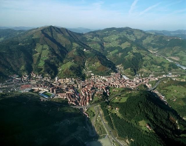
The sprint had to take place in Eibar, because of its historic position in the sport's development. As the hometown of not one but two prominent bicycle manufacturers (Orbea and BH), the city played a formative role in the creation of the Vuelta via the 1935 GP de la República, as well as these companies helping to sponsor the riders in the early editions. Its prominence therefore is far in excess of what you might expect from the average city of 25-30.000 inhabitants. The Club Ciclista Eibarrés is responsible for the organization of many events, and was the principle mover behind the creation of the Bicicleta Eibarresa, which became the Euskal Bizikleta, in the 1950s. The club still organizes the Memorial Valenciaga, a famous amateur race with a prestigious winners' list including Jokin Mujika, Óscar Freire, Joaquím Rodríguez, Chechu Rubiera, Mikel Nieve and Unai Osa, and is the main reason behind the annual MTF at the Santuário de Arrate in the Vuelta al País Vasco.

The climb to the Santuário de Arrate is legendary in its own right, of course; the Subida a Arrate was introduced all the way back in 1941 as a mountainous one-day race finishing on the climb up to the famous summit with its brief descent to the line, and ran all the way to 1987 when it was merged into the Euskal Bizikleta to serve as its final stage. While early editions were quite provincial, including four wins for Martín Mancisidor, who outside of one Vuelta GPM never achieved outside of the Basque Country, its prestige rapidly increased, and it has been won by several major names in Spanish cycling history, from Jesús Loroño, Manolo (Castilianized to Manuel) Rodríguez Barros, Julio Jiménez, Gonzalo Aja, Francisco Galdós and Ángel Arroyo to Alberto Fernández - whilst the list of foreign winners is small but impressive - Raymond Poulidor (twice), Johan de Muynck and Stephen Roche are the only extranjeros to triumph here. The most decorated rider at the Subida a Arrate is Federico Bahamontes, who won five consecutive editions from 1958 to 1962. The climb hosted the second MTF in the Vuelta's history, just one day after the Formigal raid previously mentioned. Crashing badly on the way into the Montes Vascos, the Basque fans who had been aggrieved at local favourites Perurena and Lasa being shunted down the GC thanks to Fuente's raid instead gave Tarangu a hero's welcome when he emerged in Eibar bleeding profusely from the head, but refusing to concede time as he tore through the field in pursuit of the leaders on the climb. It was also brought back in 1974, and once again Fuente was defending the race lead and once again Agustín Tamames won the stage - it was not until 2012 that the race went back, so it retained that legend, much like when Gilberto Simoni won the first two climbs of the Zoncolan, except a much less dramatic climb and a record held for much longer. Since the summit became an annual event in the Vuelta al País Vasco, it has developed another level of mythos. The fastest ever ascent of the climb came in 2011, when a small group were unable to break one another; the first over the summit and therefore official record holder is Xavi Tondó. This held even after the 2012 Vuelta when, in better weather than we're used to at the Itzulia, and in a much easier stage overall than we're used to in the Itzulia, we saw Purito, Valverde, Contador and Froome doing battle.

Of course, here, we're not climbing Arrate in full, only to Ixua, which we always see in the Vuelta al País Vasco before a circuit including San Miguel brings us back to Eibar. However, this is a legit cat.2 climb, including all of the steepest parts of the climb, just losing the false flat and descent.

8efe4776.jpg


The descent here takes us into the village of Etxebarría, which gave us cult hero and breakaway king Amets Txurruka, and then onward into Markina-Xemein, famous as the birthplace of zesta punta, also known as jai alai, the most internationally-renowned (and insane) variety of pelota vasca. We then start to innovate a bit, at least after one more well-known ascent, this being the climb of Gontzegaraigane. Having been used in the 2014 and 2015 Vueltas al País Vasco (in the time trial of the former too) it's a well known ascent and probably worthy of categorization ordinarily, but here I've elected to go the "no puntable" route. It was also the site of the very dramatic battle on the final day of the 2015 Emakumeen Bira, with the isolated Niewiadoma trying to defend a GC lead of one second against Emma Johansson and Ashleigh Moolman-Pasio, knowing they would beat her in a sprint and deciding attack was the best form of defence.

But here, it's just an inconsequential set-up before the brutal, monstrous, nasty ascent of the Alto de San Kristobál, on the shoulder of the mythical Monte Oiz.

OizN.gif


What we're climbing is that, until the 2km to go marker. The max is 23%, there's 500m averaging 17%, it's all brutality. And what's worse? The last 3km of the climb are on hormigón, so there's nowhere to hide - this is a mini-Bola del Mundo.

oiz-munitibar.jpg


Never before ascended in cycling competition, Monte Oiz is a dramatic mountain overlooking the city of Durango and known as the "Mirador de Vizcaya". It is a legendary place in the traditional myths and legends of the Basque people, and with a distinctive signal antenna and parque eólico at its summit, is easily recognizable among the other mountains in the vicinity. It's nicely accessible from Durango (itself on the autovía and the Euskotren, the region's narrow-gauge railway, so there's no excuse for fans not to line the roads, as if the Basques wouldn't go to line the roads for a major bike race anyway), although this northern face with its monstrous hell-slopes is a bit tougher to get to. The climb crests just inside 60km from home, because this is a short stage - but if the gaps created by yesterday's time trial are sizable enough, it's worth testing out the opponents' legs here - certainly 3km at 12% on hormigón should be enough to make a lot of domestiques' legs pop, making for an interesting time in the rest of the stage.

The descent is much more manageable than the climb (remember, we're not including the 2km from the Ermita de San Kristobal to the summit) and after the first couple of kilometres we're back on tarmac to make it a bit more reasonable for the riders to take on. Nevertheless, it's a very twisty and technical descent, so getting back on could become a challenge. At the bottom of the descent lies Durango, a prominent city with a proud history.

arco-de-santa-ana-durango-vizcaya_10504.jpg


Durango's cycling history in recent times is primarily concerned with women's cycling; having subsumed the small town of Iurreta within its borders, it is the hometown of both the Emakumeen Bira stage race and its preceding one-day race, the Durango-Durango Emakumeen Saria, which uses many of the same climbs as the Klasika Primavera Amorebieta. It is also the hometown of the splendidly-named Eneritz Iturriagaetxebarria, who like Francisco Gabica often abbreviated her surname to just Iturriaga, part of a prominent cycling family in the area - in fact their bike shop, Ciclos Iturriaga, also sponsors an amateur team in the area, with some distinctively-coloured hot pink jerseys.

'twas not ever thus, however. In 1975, a short stage from Durango to Bilbao was won by the Australian Don Allan (who also was the first Australian to win a stage at the Peace Race), and two years later another stage left the town, to Miranda de Ebro, becoming the record-breaking 13th stage win for Freddy Maertens that year. Although the town only hosted the race on these two occasions, however, it was passed through almost annually as a tradition, because it sits at the foot of the most mythical of all Basque climbs, the holy Urkiola.

parque-natural-urkiola.jpg


The Urkiola natural park is renowned for some of the best scenery in the whole Basque region, which as many of you know means it's up against some serious competition. This mythical set of mountains, led by the mighty Anboto (here seen overlooking the legendary sanctuary), is the bridge from the mountainous lowlands to the plateau, and the home of the goddess Mari, controller of the weather and one of the principle figures in pre-Christian Basque mythology. It is a mythical and legendary place in all walks of Basque cultural life, and cycling is unsurprisingly no different, what with an incredible, sinuous road draped over the craggy mountainside that leads us from Durango to the summit.

urkiola1.gif


At 5,7km averaging over 9%, this is a typical Basque climb in so many ways, and in others it is truly the greatest of Basque climbs. The point marked Txakurzulo on the profile there is one of the most evocative in cycling, the riders emerging from a sheltered, forested area around a right hand sharp bend when the trees move away and behind the riders, glorious vistas emerge, but before them a nasty straight ramping up to 14% emerges, and this is where the fans always line the road most fervently.

6c57c64e.jpg


The Urkiola has as long a history with cycling as any climb in Spain. The Subida a Urkiola, one of the greatest climber's classics ever devised, was first run in 1931 (won by Ricardo Montero), and although it faced periods of inactivity, it continued all the way until 2009 when it was won for the final time by Igor Antón. It has a prestigious list of victors, from Karmany and Julio Jiménez back in the 60s through to its resurrection in the 80s, where we saw the likes of Lejarreta, Hampsten, Delgado, Chiapucci, Rominger, José María Jiménez, Piepoli, Frigo, Rodríguez and Mayo triumph on the hallowed summit. It served as one half of a weekend's Basque action alongside the Clásica San Sebastián, but the implementation of the ProTour harmed the race significantly with it not attracting the same attention as Donostia as a result. Nevertheless, there's still a lot of prestige attached to the climb, not least as it was the hardest climb of the very first Vuelta (the summit being won by the Italian, Luigi Barral), and became an almost everpresent climb in the early days of the race all the way until the Basque Country was taken off the agenda. The summit has been taken by many great climbers, including Karmany, Julio Jiménez, Vicente López Carril and Luís Ocaña, before being introduced as a mountaintop finish in 1975; Agustín Tamames won on the climb on that day en route to overall victory, with José Nazabal cresting the summit first in 1977, although Maertens lead was more than safe enough by that point. As such it was an obvious pick for a return in 2011, although it was the final climb in the relatively tame 20th stage with its long flat run-in to Vitória-Gasteiz, with Carlos Barredo's escape on the climb being pulled back letting Daniele Bennati take the stage.

Here, however, the flat is much shorter, with Urkiola being just over 30km from the line, and with a shorter stage and few opportunities to make time up after this and domestiques having been dumped out the back on Monte Oiz, hopefully we should see more action. The plateau is only long enough to take us to Otxandio, the hometown of 1946 Vuelta winner Dalmacio Langarica, the first Basque Vuelta winner. He won eight Vuelta stages (five of which were the year that he won) and six stages of the Volta a Portugal, but struggled mightily when racing outside of Iberia, for this was during the height of comparative isolation and for the Spanish riders chances to race against the elite competitors from France, Italy or the Benelux countries were quite rare. He later became a team manager, most prominently at Ferrys, the early days of KAS, and with the national team, and died in 1985 at the age of 65.

langarica-dalmacio.jpg


An uncategorized climb takes us into Areatza, whereupon we take on the final mountaintop finish of the Vuelta, an unheralded and little-known climb called the Alto de Pagomakurre, which sits in the Peñas de Itxina, in the shadow of Monte Gorbea. Again - while much of the Basque country is well-known terrain to cycling, it still has the occasional surprise in store. And a 9km climb at 8% with ramps of 14% and two whole kilometres at 11,4% in the middle being unknown, with Javier Guillén's current activity, is in and of itself surprising. Especially when it's totally ridable and has an actual car park at the summit. This isn't any cramping-the-race-into-a-clearing technique like we did at the Santuário de Muskilda, oh no. There's ample space at Pagomakurre for plenty of parking, as it is a popular stop-off point for hiking trails en route to Monte Gorbea and the other nearby Basque mountains.

LarrederPagomakurre.gif


LarrederPagomakurre.jpg


So, this climb isn't really long enough to leave everything to it, but if you go all out earlier you might pay here - but then it's a short stage so what do you have to lose? Riders will have to wrestle with their instincts also, as the climb's hardest terrain is in the middle. And they probably won't have many helpers since you would hope they had been burned away by the previous two climbs, and if that doesn't do it, the 11km sections will get rid of any of them left. The climbers have got to make today count, and I've given them, with Oiz inside 60km to go and Urkiola at 30, options to go from afar if they dare. Hopefully some secondary contenders or strong contenders whose GC position is more disappointing than they'd hope will be persuaded to redeem themselves like Andy Schleck in 2011... and the Parque Biotopo de Itxina, which gives its name to the stage in the same way as Sotres = Jito d'Escarandí, Lagos de Somiedo = La Farrapona, Finhaut-Emosson = Col de la Gueulaz and so on, gives us a pretty glorious backdrop too.

20070602Beltri01.jpg
 
Jun 11, 2014
304
0
0
Great basque stage, LS - puny gradients all over the stage!

Counterclockwise Vuelta II

14. 200,3 km Vic-Coma Oriola - Mountain Stage

Allright, massive 5500 heightmeteres coming up in Catalonia. When I did my first Vuelta and also this one - I must admit I had a good idea about where I would be going regionally, and the stages itself. But I also found the Pyrenees stages I have dreated as the most difficult of the lot - so many options, but also so many roadblocks and so little knowledge.
Yes - I managed to get around the wrong side of Coll de Pal (as i.e. Pradell as lead-in) - but I wanted a slightly easier finish - to ensure earlier action - but also comparable fresh legs for tomorrow.
QRYowNZ.png

Stage description:This ugly saw-toothed stage has not only lot's of climbing - but also lots of different styles of climbs - with steeper ones coming first - and the grinding ones in the end. This can be ugly for the grupetto!

We start in Vic and go straight north to Torello on more or less flat roads. 203 km to go - and in Torello today's first climb: Coll de Bracons starts, albeit with a 14 km rising false flat. But the key 5,2 km of the climb is serious - irregular - 12 % ramps and 7% in average, and the we reach an ugly 7 km descent.
A totally flat 5 km valley piece awaits, before a lot of the domestiqes will blow away, when they hit the 6,5 km wall of Collada de Collfred, this piece of the climbs is averaging two-digits :exclaim: , with ramps of 14,15,16 & top of the icing 17,1%. This is attack terrain! The next 6 km is a walk in the park compared to this before a final kick to the top. The descent is much more regular and steady for 8 km, before we take a paved backroad north through 25-30 km of rolling terrain with climbs that would have gained a cat.4 in the Le Tour.
This ends in Ogassa - Coll de Jau is waiting - we are 80 km from the finish line - and it a Steep-mild-steep climb hitting 12% over a km and highest pitch of 17% in the first 1/3 of the climb. As with CollFred, the descent is more regular and manageble and is folowing by a 15 km descending valley flat.
Into the final 50 km we take on Coll de la Creueta. A complete different climb - more classic spanish with lots of 6-7% streches but it will also bring us up in the almost 2000 meter above sea level, so it will take it's toll on the rides!
The descent of 15 km is soft 5% and takes us to the town of Alp to the final climb og today - The Coma Oriola - a steady diesel climb - around 7% all the way on the the little parking lot at the top, with it's steepest ramp in the bottom.

What action might happen ? Well, the stage is designed to get rid of helpers early (coll-fred) and the use Jou as springboard for the explosive people, or Creueta for the more steady rytmic ones, while the sheer force of exhaustion will mean everybody is on their own on the finish climb.
lnofpHG.png


Elevation Gain/Loss in m: 5489/4032
Mountains/hills: 5 (5 categorized)

Coll de Bracons (west). 37,1 km 2. KAT. 5,2 km - 6,9%
Collada de Collfred (east). 162,4 km 1. KAT. 13,0 km - 6,4%
Coll de Jou (east). 115,3 km 1. KAT. 13,9 km - 6,2%
Coll de la Creueta (southeast). 168,1 km 1. KAT. 20,0 km - 4,8% (The sharp descent in middle of the profile is a mistake by my hand - and we count from km 20)
Coma Oriola (Alp). 203,3 km 1. KAT. 31,0 km - 6,9% (last 11 in profle)

Other considerations:

1. stage 169,5 km Huelva-Sevilla: Flat
2. stage 46,5 km Jerez-Cadiz: TTT
3. stage 192,1 km Vejar de la Frontera-Ronda: Medium Mountains
4. stage 150,8 km Ronda-Antequera: Flat
5. stage 158,5 km Antequera-Motril: Flat
6. stage 129,8 km Motril-Puerto de Ragua: Mountain - MTF
7. stage 200,6 km Granada-Cordoba: Flat
8. stage 129,8 km Bujalance-Sierra de la Pandera: Mountain - MTF
9. stage 194,6 km Guadix-Almeria: Medium Mountain
---Restday---
10. stage 144,6 km Cuenca-Teruel: Flat
11. stage 179,7 km Teruel-Escucha: Medium Mountain
12. stage 185,0 km Alcaniz-Tarragona: Flat
13. stage 185,0 km 54,4 km Tarragona-Sitges: ITT
 
Stage 18: Miranda de Ebro - Palencia, 219km

34t4a4x.png


swz7dz.png


GPM:
Alto de Cevico de la Torre (cat.3) 2,3km @ 5,9%

Week 3 transitional stages a-go-go in Spain, as the riders get one of their few easier days in the Vuelta. Week 3 sprint stages tend to throw up some comparatively unusual results in the Giro and Vuelta, with the importance of sticking around to the end less apparent without the Tour's iconic Champs Elysées finish and with, in the latter case, the World Championships coming up so that if the Worlds are relatively flat you would anticipate most of the contenders to have gone home to save themselves for it. And also, perhaps more so at the Vuelta but also applicable at the Giro, the fact that the points competition is not heavily sprinter-weighted like the Tour's classification means that a stranglehold over the competition is much harder to attain - especially with the Vuelta often featuring over half of its finishes uphill in some shape or form (in this Vuelta there have been 8 thus far - Mirador de Lobeira, El Dornajo, Cálar Alto, Santuário de la Fuensanta (no puntable), Cuenca, Formigal, Santuário de Muskilda and Pagomakurre, with a corresponding 5 likely sprints - Lago de Sanabria, Ciudad Real, Albacete, Calatayud and now Palencia) which makes the likelihood of keeping the jersey low enough that it is less of an incentive to stick around and contest the final week sprints. Especially bearing in mind the riders, since the last sprint opportunity, have had to drag themselves up to Formigal, over a five mountain odyssey to Muskilda, survive the time cut around a 60km chrono and pull themselves over several Basque mountains to earn the right to contest this win - so it's likely that in fact many simply won't bother, so we could get an unruly and wild sprint or a late escape such as that when Anthony Roux fooled the sprinters in Talavera de la Reina in 2009.

6851a48f630c82c9697282b27b8fa0c1.png


Settled in Roman times, the city of Miranda de Ebro is, as its name suggests, on the Ebro river and is the second largest city in the Provincia de Burgos, after Burgos itself, with a little under 40.000 inhabitants. Although the city has a long history, it came to prominence in the 19th century, where it became an important railroad connection from Madrid to the northern cities; its proximity to the borders with both the resource-rich País Vasco (in fact, in the original provincial divisions of Spain the town - as it was then - was located within Álava, and by extension what we would now call the Basque Country) and La Rioja placed it in an ideal position to help ferry products and resources to the capital. The city also has a darker side, hosting a nationalist concentration camp in and following the Spanish Civil War, the last of these to close, lasting all the way until 1947 before being abandoned.

The location between the province of Burgos, which has held the Vuelta's prime warm-up race since the move of the main event to September, and the Basque-Navarrese hub, has led to a long history with cycling in the city. In the early days of the Vuelta, the linking solely of larger cities meant that Miranda was only ever seen in transit, although the many stages that linked cities like Santander, Burgos, Bilbao, Vitória-Gasteiz and Logroño would often pass through. The presence of so many big cities in a cycling-rich environment hosting several stages every year in the Vuelta meant that the call for another stage town in the region was limited, but when Miranda did finally step forward and get itself a stage finish, it was an interesting medium mountain stage with Alisas, Los Tornos and finally Orduña, and the first man to win in the town was a little-heralded breakaway arti... oh, who am I kidding. It was 1973, so obviously it was Eddy Merckx.

Agustín Tamames was the next to win into the town the following year, in a short, sharp stage over Urkiola, Aiurdin and Orduña, with a similar stage being used in 1975 and being won by Hennie Kuiper.

4357756362_d65531272d.jpg


In 1977, the town was back, even hosting the race's grand finale, with a short stage from Durango after a MTF on the Urkiola the previous day, and therefore it served as the venue where Freddy Maertens broke the Vuelta's age-old stage wins record set by Delio Rodríguez back in the race's infancy. 1978's race saw a short one-climb stage where Jean-Philippe Vandenbrande became the first rider to win in the city without being a GT winner or World Champion; it was the biggest win of the Belgian's career.

After this, however, the city fell off the race's map. The reasoning is sound; while Miranda de Ebro is not in the Basque Country, the proximity of the city to it would make it a natural target; not only that but the main reason the city had become a regular host in the 1970s was that its relative proximity to classic climbs like the Puerto de Orduña and the Puerto de Herrera made it an attractive racing proposition; with those climbs now out of the question for the race, the reason for finishing a stage in comparatively small Miranda or Haro when you could finish in Burgos or Logroño instead was limited. And unlike Euskal Herria, the Vuelta has never gone back to Miranda other than, like in the early days, to pass through. The city has, however, hosted the Vuelta a Burgos almost annually, especially with the puncheur finish at San Juan del Monte, nestled in the nearby hills, which has served as an interesting way to break the field up with some small time gaps in years past.

2102833.jpg


This stage is, however, pretty flat, as we traverse the Provincia de Burgos into the neighbouring Provincia de Palencia, across mostly flat plateau land with a couple of bumps along the way. The first part of the stage, however, is mildly uphill culminating in the uncategorized ramps around the small town of Monastério de Rodilla, built around the eponymous monastery. This takes us up to the plateau proper, where we have an early first intermediate sprint, although it's not a nice easy flat sprint, instead it's a slightly awkward ramp up to the Castillo de Burgos, which offers puncheurs an option although it's not beyond the more versatile sprinters to pick up the points if they want to keep the break that tightly monitored, as it's been won by Juanjo Lobato in the past, albeit not in typical sprint fashion.

Castillo-de-Burgos_burgos.jpg


After this, however, it's a long, long plateau where the biggest threat will be the wind, as otherwise some tired legs are going to be preserving themselves, thinking of Madrid. There is a brief period of bumpy terrain around the town of Antigüedad (yes, really) but this shouldn't be anything that all but the most woeful climbers (hello Guardini!) struggle with. The region of Palencia is far from flat, however; we're not going anywhere near the 'real' climbs of the region in its north, however there are a number of small elevated plateaus to the south and east of the province's namesake city, which allow for us to add a couple of climbs to the stage and produce something that isn't exactly going to break things apart but does give a platform for attacking.

We only climb two of these actual hills, mind; and neither are killers. The first, cresting 28km from the line, is between Población del Cerrato and Cevico de la Torre and is 2,1km @ 5,9%. The second, cresting 20km from the line, is slightly longer with a similar gradient, and links Cevico de la Torre with Tariega de Cerrato. Again it's not super hard but the 250m at 13,6% there offers a platform to attack in, and the two climbs back to back allowed me to justify a categorized climb.

ayuntamiento-tariego-de-cerrato-10680188.jpg


After descending into Tariego de Cerrato, however, the riders negotiate the town of Venta de Baños, before what is a primarily very straight and fast run into Palencia which will favour the bunch. Venta de Baños last saw professional cycling in 2003 with a Vuelta a Castilla y León TTT won by an iBanesto.com team featuring Denis Menchov, Evgeny Petrov, Paco Mancebo and Javi Pascual, so it's been some time since they've seen racing. Not so the nearby city of Palencia, the provincial capital and today's finish, which has seen the Vuelta a Castilla y León three times since then - a 28km ITT in 2009 won by Levi Leipheimer, a sprint stage in 2011 won by Fran Ventoso, and most recently an undulating sprint stage in 2013 which proved we were truly living in bizarro world at the time, as Juanjo Lobato again took the victory, which after Urtasun the previous day meant that Euskaltel-Euskadi won their second consecutive sprint stage. No, really.

Palencia isn't a traditional stage town by any means but it's been seen several times over the Vuelta's history owing to its convenient location halfway between the northern coastal cities and Madrid in the middle of Castilla y León. It was first seen in 1958 when Rik Luyten won a sprint on the penultimate day of the race, and António Suárez won an ITT in the city three years later. In 1965 it was the second half of a brutal double-stage, with a 40km MTT to the Puerto de Pajáres in the morning followed by a 190km stage to Palencia; race leader Rik van Looy lost eight minutes in the cronoescalada and subsequently ceded the lead to defending champion Poulidor, consequently there was little interest in the ensuing stage from the prime sprinters. The most illustrious rider to win in Palencia in the Vuelta, therefore, is Sean Kelly, who took a stage in 1986, though the Spanish retain a bit of fondness for Ramón "Tarzán" Sáez who won here in 1968, one of the first home-grown sprinters able to legitimately compete on a level field with the elite Low Countries sprinters that often dominated the first half of the race in that era, fresh from their spring Classics form. Here, of course, the modern sprinters will be honing their World Championships form.

Palencia--575x323.jpg


Who is here to contest the finish will depend on how the rest of the race has run and who has the jersey for the points classification. In years like 2009 and 2014, where Greipel and Degenkolb respectively had the jersey, and the Worlds were not conducive to sprinters, they stuck it out to the end. If we have a sprinter-friendly Worlds, or if contention for stage wins has meant the points jersey is on the shoulders of a contender who can fight out various types of finish and potentially remain GC-relevant, such as Valverde, then many of the top sprinters will have gone home, you would wager, allowing second-tier sprinters, or those attempting late attacks against a disinterested péloton, a chance at a Grand Tour stage they might not otherwise expect...
 
Jun 11, 2014
304
0
0
I did a much more detailed description - but when I pressed submit, it just directed me to the login screen - in anger of wasting 45 min of my life - here you have the short description.

The day before the restday - another multi-mountain odessy coming up!

Counterclockwise Vuelta II

15. 170,8 km Alp-La Farga de Moles - Mountain Stage


ChEQTCG.png

Stage description:700 heightmeters less to be climbed on the stages compared to the previous one - but for this stage, that starts and ends in Spain, it is still of the most critical ones in the race
The goes in Alp (from where the ascent to the previous finish started) and here we have several options, 1. straight west to Andorra, 2. Puymorens/Envalira or and more northeastern approach that can end in Mantet, Jau or even Pailheres...

We hit out with the Puymorens (albeit only as part of Envalira) - the safe way. long soft grind to 1920 meters. a small descent before the final ascent to the top of the Vuelta - 2400 meters at Envalira. Last 5 km is 7% and will start to hurt... we hit the descent before the easier side of the Ordino, and the easier but also irregular side of the little brute Beixalis.
Next up is Comella before a sprint, that takes us to the tough La Rabassa - where especially the first half is steep and brute - the decent is a mirror of the ascent before we hit the brutal Gallina. Tough, selective and very steep on both sides for 12 km this is a modern classic. The winner of the Vuelta will stand forward here, before the not-lighthearted descent and a flat 4 km finish on the first possible spanish site after the border.

Remember Tour 2016 Arcalis stage ? Or Vuelta 2013 Gallina stage ? Yes, thunder storms, above freezingpoint temperatures, fog and wet descents can create havoc. Such is the weather here!

One also has to acknowledge the little issue - that going down from Rabassa, roadsharing with the ascent happens. Simply to tricky to risk alot of people fighting on Gallina's steep slopes will be so delayed that the meet the desenders on Rabassa.
ONePDdq.png

Elevation Gain/Loss in m: 4835/5135
Mountains/hills: 7 (7 categorized)

Col de Puymorens (east). 36,7 km 1. KAT. 26,9 km - 2,9% (actual climb is 13,8 km with 4,2% - but for historic reason the full climb is on as a KAT 1.)
Port d'Envalira (southeast). 50,0 km 1. KAT. 10,8 km - 5,8% (last 10,8 km in profile as climb - from Puymorens as climb)
Col d'Ordino (east). 75,2 km 2. KAT. 8,8 km - 5,0% (last 8,8 km on the profile)
Collada de Beixalis (west). 93,3 km 2. KAT. 8,6 km - 6,9%
Alto de la Comella (north). 106,6 km 3. KAT. 4,1 km - 5,7%
La Rabassa (south). 129,2 km 1. KAT. 13,3 km - 6,8% (first 13,3 km in profile)
Collada de la Gallina (north). 155,3 km ESP. KAT. 11,8 km - 8,3%

Vuelta stages:
1. stage 169,5 km Huelva-Sevilla: Flat
2. stage 46,5 km Jerez-Cadiz: TTT
3. stage 192,1 km Vejar de la Frontera-Ronda: Medium Mountains
4. stage 150,8 km Ronda-Antequera: Flat
5. stage 158,5 km Antequera-Motril: Flat
6. stage 129,8 km Motril-Puerto de Ragua: Mountain - MTF ESP
7. stage 200,6 km Granada-Cordoba: Flat
8. stage 129,8 km Bujalance-Sierra de la Pandera: Mountain - MTF ESP
9. stage 194,6 km Guadix-Almeria: Medium Mountain
---Restday---
10. stage 144,6 km Cuenca-Teruel: Flat
11. stage 179,7 km Teruel-Escucha: Medium Mountain
12. stage 185,0 km Alcaniz-Tarragona: Flat
13. stage 185,0 km 54,4 km Tarragona-Sitges: ITT
14. stage 200,3 km Vic-Coma Oriola: Mountain - MTF 1.
 
Brutal stage there, though would be surprised if the Andorrans were happy to host almost all the stage but not get start or finish, as such you might have to finish in Sant Julià de Lorià unless you're going to have the next stage in Andorra (I've had thoughts of doing an Andorran mountain stage but finishing in Os de Civís, a Spanish village only accessible from Andorra, making up to the Andorrans with a CRI in Andorra-la-Vella the next day).

Stage 19: Peñafiel - Collado Villalba, 145km

in8qbm.png


rqz0p2.png


GPM:
Alto de Los Ángeles de San Rafaél (cat.3) 5,8km @ 5,2%
Puerto de Guadarrama/Alto del León (cat.3) 5,7km @ 4,9%

In the Vuelta we move back down towards our capital city finale with a second transitional stage in a row, albeit this one is a noticeably shorter stage and with the two climbs being more significant and closer to the finish than in yesterday's stage, so the character should be different as this will be a nice one for the break as well as offering some potential for more significant action, though I suspect the primary GC men will leave this one be with tomorrow in mind.

Castillo-de-Pe%C3%B1afiel-hola.jpg


Peñafiel, which hosts today's stage start, is a town of around 6.000 which is south-south-east of yesterday's finish in Palencia and lies around halfway between Aranda de Duero, and its provincial capital of Valladolid. Indeed this is part of the flattest of the provinces of Castilla y León, since Valladolid is the only province which does not have a section of either the Sistema Ibérico (Burgos, Soria), the Picos de Europa (Palencia, Burgos, León), the Macizo Galaico (León, Zamora) or the Sistema Central (Ávila, Segovia, Salamanca). As such, it's not seen the Vuelta rock into town often as the race, when moving across the Meseta with transitional stages, has normally elected until recent years to finish in the larger nearby cities such as Palencia and Valladolid. The city dates back to the middle ages, although there was a Roman settlement on the site, from which its name derives. It is famous for its castle, sat on the promontory overlooking the town centre, and for the large sanded central square, Plaza del Coso, which is used as a bullfighting ring during the festival of San Roque, with crowds assembling around, in and even on top of the houses overlooking the square.

It is perhaps appropriate that we should be in Peñafiel given recent cycling news - having been unable to find a team, Slovakian Peter Velits has just retired from the sport. It's a bizarre story of a fall from grace from a man, even taking into account the injuries he has had; he's a man who emerged from nowhere to podium a Grand Tour without ever really being noticed doing so, and has never even remotely looked like recapturing that level. I know that I had many things to say about the sprint-focused HTC team of the time but certainly there are a lot of riders who looked like worldbeaters in that era who have struggled to keep that level up elsewhere. Velits is perhaps the most extreme example, because while they struggled to turn the likes of Tony Martin and Mick Rogers into genuine GC threats, Velits managed to actually become one. His GC bid was built almost entirely on hanging on in the mountains, and of course his podium was extremely fortunate because it likely wouldn't have happened had Igor Antón not crashed out from the lead of the race in dramatic fashion, but he did win the 46km CRI in Peñafiel in that edition despite being such a non-entity that the cameras didn't even bother picking him up until he arrived at the finish (instead the cameramen choosing to focus on Mosquera's surprisingly competitive performance, and J-Rod's complete implosion). The city returned as a stage host in 2012, in similar fashion to the way I use it here, as the start of stage 19, a week 3 hilly transitional stage to La Lastrilla, near Segovia, which was won by Philippe Gilbert because of course it was.

This is a short stage, so the pace should be fast in the break, who will want to be allowed to duke this out with the GC men tired from three weeks of tough competition. The first half of the stage is also exposed to wind, however, so that is likely to be the biggest issue early on, so the most important GC riders will want to fight to ensure they're well placed - although this is likely to be a lot safer than had the same situation occurred in week 1, when riders all have something to protect. We actually go through La Lastrilla and descend that same hilly finish used in 2012, but this just takes us into the famous Roman city of Segovia for an intermediate sprint which takes place in front of its legendary Roman aqueduct.

segovia-akvedukti.jpg


Segovia of course has a long and legendary tradition of hosting the Vuelta, first hosting the race in 1948 when Miguel Gual won in the city on the penultimate day, the last of his four stage wins in that edition. The city's proximity to Madrid along with legendary Vuelta climbs like the Puerto de Navacerrada and Puerto del León have made it a common stop-off point, either being passed through or hosting on many occasions, with the most recent finish in the city having come on the short cobbled climb to the city's west, in week 3 in 2008, with David Arroyo winning a stage in unpopular fashion after monitoring a break all day for Alejandro Valverde, telling his breakmates he would not work, but with the péloton underestimating the strength of Vasil Kiryienka, the Belarusian machine able to hold them off, so Arroyo took advantage and outsprinted him in the resultant two-up finish. This ride almost single-handedly won Kiryienka his contract with Abarcá; Unzué was so impressed with his strength in this stage deep into week 3 that he immediately went to talk to him. The following year Vasya was Don Alejandro's personal minder in his Vuelta triumph. The finish aped the one used in the 1995 National Championships, which were won when Banesto set up a break in which they had four of the seven riders, and so Jesús Montoya won ahead of José María Jiménez, which in turn were derived from the 1972 championships won by Luís Ocaña.

In recent years Segovia has been less common on the route, as when the race has been nearby it has stopped at the palace at La Granja de San Ildefonso (such as in 2009 when Juanjo Cobo won) or the Destilerías DYC in Palazuelos de Eresma (most notoriously in 1985 when Robert Millar lost the Vuelta on the penultimate day). It does continue to host the Vuelta a Castilla y León, however, most recently in 2012 when surprisingly Caja Rural's Panamanian prospect Yelko Gómez outsprinted a small group including Javi Moreno, Brice Feillu and Matthew Busche for his biggest career triumph. The city has a greater heritage to cycling fans, however, as the hometown of three time GT winner (one Tour, two Vueltas), Pedro Delgado.

WATSON_DELGADO_00001362-592-M.jpg


Perico was Reynolds' second real long-term leader (Ángel Arroyo his predecessor), and the first to bring real success to a team whose lineage includes legendary exploits from the likes of Indurain, Olano, Jiménez, Zülle, Mancebo, Valverde and now Quintana - however he left the team in 1984 after a disappointing season, harmed after a crash in the final CRI in the Vuelta caused him to drop from 2nd to 4th in the GC. Moving to the nascent Seat-Orbea squad, he played a role in one of the most controversial Vueltas of all time, of course, being the man to profit when the organizers played games with the time gaps on the boards and Robert Millar's arrogant attitude at the start of the stage riled other riders up enough that they wilfully sabotaged their own aims, sitting idly by to make him chase Delgado, who had help from stagehunter José Recio, and causing Perico to ride into a finish near his hometown (it was at Destilerías DYC) to wild celebrations as the home Vuelta winner (Recio was understandably given the stage). Many sections of the Spanish press were excited that, after generations of the home riders ruining each other's chances and teams imploding through internal rivalry meaning the Vuelta was being won by extranjeros regularly, they had finally got it together, but others were also keenly aware that such racing would also discourage teams and riders from elsewhere from contesting the race, if they felt they were going to be conspired against. It was a very charged moment in the race's history and is still controversial today.

Delgado of course would go on to win the Vuelta outright without such controversy in 1989, winning three stages en route (the MTF at Cerler, the MTT at Valdezcaray, and the ITT at Medina del Campo), and of course by that time he'd also achieved his greatest triumph, winning the 1988 Tour de France over former PDM teammate Steven Rooks, taking the maillot jaune in the Alps and underscoring his advantage with a stage win in a hilly time trial between Grenoble and Villard-de-Lans. Of course, coming into the 1989 Tour Perico was the reigning champion of both the Tour and Vuelta, but the 1989 Tour started in memorable - and ignominious - fashion for him, after he turned up for the prologue over two minutes late, brutally damaging his GC bid. Of course, the 1989 Tour is fondly remembered for the tightest finish in Tour history with the Champs-Elysées contre-le-montre and Lemond's 8 seconds, but Perico was 3rd at +3'34 - 2'54" of which were lost in the opening prologue.

That was it for Delgado as a GT champion; he was 2nd in the 1990 Vuelta - the best of the expected GC men, but Marco Giovannetti was given too much rope in week 1 and was able to hold on by 90 seconds from the 1988 Tour winner. Perico made the podium of the Vuelta twice more, in 1992 and 1994, but by that point Rominger's reign of terror was underway and he was unable to compete with the Swiss brute. Overall though, Delgado was an incredibly consistent champion over a decade of performances at the top level, and eventually managed no fewer than 18 GT top 10s (1 at the Giro, 8 at the Tour and 9 at the Vuelta) including 3 wins and 5 further podiums, which is one of the reasons he's so highly regarded many years on.

Angeles-de-san-rafael.jpg


Heading southwest through the foothills of the Sierra de Guadarrama, we retrace that 1985 stage's closing stages (in reverse), until we arrive outside Los Ángeles de San Rafaél, which enables us to incorporate a nice little climb, a two-stepped ascent with ramps of up to 17% which has been included in the Vuelta a few times, most notably in 1974, when a semitappe over Navacerrada and El León with a punchy finish in the city was won by José Manuel Fuente, followed by Raymond Delisle winning a short MTT on the climb, with Fuente again coming 2nd, taking enough time to take the jersey he would hold until the end, and in 1997 when a series of small attacks led to a small group at the end and a brutal attack on the final ramp led to Chava's first Vuelta stage win, in the King of the Mountains jersey as is only right and proper for a guy like him. Here, however, it's not the finish, it's just a cat.3 climb 32km from the finish, so while the steep ramps do offer something to do for the stronger climbers in the break, it may be risky to take it from here, so I think they will prefer to use a high tempo to try to drop some of the faster but less versatile men in the group.

The riders then have a mild descent into San Rafaél, before taking on the second climb of the day, another legendary ascent in the Vuelta's history, the Puerto de Guadarrama, also known as the Alto de los Leones, the Alto del León or the Puerto del León. It's gradually steepening with two kilometres at 7% near the end and cresting just 18km from the line, so this should be a good opportunity for some moves for the stage win, especially with half of the remainder of the stage being a fairly fast descent.

Restaurante-asador-Alto-del-leon-guadarrama-terraza-500x3002.jpg


There is a solid case to be made for the Alto del León being the most traditional of all Vuelta climbs given how often it has been used - twice (once from each side) in the very first Vuelta back in 1935, for example - and it was a near-annual fixture through the early days of the race. It became less frequent in the 1970s, but with its competitors for most traditional climbs other than nearby Navacerrada being taken off the menu when the Vuelta excluded País Vasco after 1979, it came back on the agenda with several passes in the 1980s and 1990s, although it has not been used since it was climbed from its harder side, which we descend, early in the Bola del Mundo stage in 2010.

Many great climbers have been the first to the summit here - Julián Berrendero in 1945, Jesús Loroño in 1950 and 1957, Julio Jiménez in 1961, Antonio Karmany in 1962, Fernando Manzaneque in 1965, José Manuel Fuente in 1974, Faustino Rúperez in 1981, Pedro Delgado in that infamous 1985 stage and José María Jiménez in 1997. Here, who will be the next to stamp their name on the climb, before a fast descent into Collado Villalba?

Villlaba+vista+a%C3%A9rea.gif


This city of 60.000 inhabitants sits at the foot of the Sierra de Guadarrama and has long been involved in cycling. There used to be the Clásica de Alcobendas y Collado Villalba from the mid-80s until its final edition in 2008, a short stage race in the Sierra de Madrid that had many illustrious mountain specialists among its winners, with the race annually including an MTF at either Navacerrada or Los Leones - Laurent Jalabert, Abraham Olano, David Moncoutié, Joseba Beloki, Iban Mayo, Pavel Tonkov and finally Ezequiel Mosquera among the winners. The city has also hosted the Vuelta a few times in recent years, most recently the 2007 penultimate day time trial won by Samuel Sánchez. The last time the Vuelta saw a road stage in the city was 2004, when a transitional stage including Abantos finished with a flat run-in after the San Lorenzo de El Escorial punchy climb and Constantino Zaballa won solo ahead of the remainder of the break he'd attacked, with the favourites coming in together 6 minutes down. In 2003 a stage over Navacerrada finished here, Filippo Simeoni outsprinting Claus-Michael Møller from a two-up a few seconds ahead of the 20-strong heads of state group, while in 2002 Møller again had had a near miss, being outsprinted by Pablo Lastras and a mythical being named Zubeldia.

Here, again, we can probably expect a tricky stage going to the break a few seconds up as the main contenders keep it cagey. But the final weekend is coming.
 
My second Vuelta!
http://www.la-flamme-rouge.eu/maps/tours/view/4321

1 Individual Time Trial Lugo > Lugo 7.21 Km
2 Medium Mountain Lugo > Cedeira 205.76 Km
3 Medium Mountain Ferrol > Vilagarcia de Arousa 225.41 Km
4 Medium Mountain Sanxenxo > Ourense 153.90 Km
5 Medium Mountain Monforte de Lemos > Puebla de Sanabria 209.80 Km
6 Medium Mountain(HTF) Zamora > Plataforma de Gredos 178.11 Km
7 Plain Talavera de la Reina > Ciudad Real 175.79 Km
8 High mountain(MTF) Puertollano > Sierra de la Pandera 199.41 Km
9 High mountain(MTF) Jaen > Collado del Alguacil 215.84 Km
Rest Day
10 Individual Time Trial Alzira > Valencia 50.13 Km
11 High mountain(MTF) La Vall d'Uixo > Mont Caro 169.78 Km
12 Plain Plain Reus-Solsona Reus > Solsona 156.82 Km
13 High mountain(HTF) Tremp > Pla de Beret 192.07 Km
14 Medium Mountain Sort > Sabinanigo 217.00 Km
15 High mountain Ansó > Ochagavia 174.44 Km
Rest Day
16 High mountain Puerto de Vega > Cangas del Narcea 166.98 Km
17 High mountain Pola de Laviana > Pola de Somiedo 213.69 Km
18 Plain Leon > Reinosa 179.20 Km
19 Individual Time Trial Solares > Noja 51.17 Km
20 High mountain(MTF) Bilbao > Santuario de Urkiola 222.65 Km
21 Plain Alcala de Henares > Madrid 112.79 Km

Total ITT km: 108.51
Total distance:3477.95

8 ESP climbs
Sierra Nevada Las Sabinas
Collado del Alguacil
Mont Caro
Puerto de Larrau
Alto de Bustantigo
Alto de la Cobertoria
Puerto de Trobaniello
Puerto de San Lorenzo

18 1C
Garita de Herbeira
Monte Xiabre
Alto de Pena Negra
Sierra de la Pandera
Alto del Monachil
Port de Canto
Port de la Bonaigua
Col de la Pierre Saint Martin
Col d'Ahusquy
Col de Burdincurutcheta
Villanueva de Critobal
Santuario del Acebo
Puerto de Las Senales
Alto de Elosua
Alto de Arrate
Monte Oiz(x2)
Santuario de Urkiola
 
Not overly happy with some of the stages though as my stage 15 in this Vuelta is very similar to stage 15 in my other Vuelta.Also stgae 20 uses Oiz twice and Arrate once,which were also used in my previous Vuelta.Also my original stage 15 was Jaca-Paso Tapla with Somport,Soudet(via Houratate and Labays),Larrau and Paso Tapla and my stage 11 was a flat or a transitional stage so if the Paso Tapla stage fails(which has a very high chance) the 2nd week would be a snoozefest so I made stage 11 a MTF at Mont Caro which would make it 7 categorized uphill finishes which was too much.So I changed the finish to Ochagavia which would make it a much easier stage than I want so I changed the start location and redesigned most of the stage and it was Anso-Ochagavia with Col de la Pierre Saint Martin(from the Spanish side),Ahusquy,Burdincuturcheta,Hegichouria and Larrau with a downhill finish at Ochagavia.
 
Stage 20: Collado Villalba - Estación de Esquí Puerto de Navacerrada, 19,6km (CRI)

2djtbo1.png


j636zl.png


GPM:
Puerto de Navacerrada (cat.1) 18,5km @ 5,2%

Ah yes, the cronoescalada. A true Spanish cycling staple, very much the escalador's race of truth in the same way a classic test against the clock is the general race of truth. And let's face it, although weirdly the only MTF I have ever done in the Sierra de Guadarrama has been at the Puerto de la Morcuera (in my third Vuelta, this is I believe the 9th), let's face it, there's not a huge amount of originality possible to show in the region given how much of a staple they have been of the Vuelta. Yes, I still have Bola del Mundo - from both sides - in my available arsenal, as well as Abantos, Valdesquí (above the Puerto de Cotos), but there aren't too many ways you can shake up racing in the area in ways the actual race hasn't already tried, unless you stick a HTF/MTF at the Valle de los Caídos, which the Vuelta's organizers don't want to do for the same reason the Deutschlandtour never finished at the Kehlsteinhaus; a Vuelta stage drawing attention to a site revelling in the glory of Franco and fascism is never going to be selected as a stage host without a lot of controversy... but how can you ensure time gaps on a penultimate day battle on climbs that the riders all know like the backs of their hands? Why, make them do it in individual start format, of course!

Navacerrada_Puerto_3.jpg


In actuality, this isn't a 'pure' cronoescalada; it is only half of one; the first half of the stage is uphill but mostly false flat, before we break to a final 9km at 7,3%, far from the toughest climb of the race, but given that this is the penultimate day and with the GC battle to be seemingly settled over these few kilometres, riders will be going all out to make them count.

NavacerradaS.gif


The mighty Puerto de Navacerrada has two sides - a northern side from La Granja de San Ildefonso, and a southern side which has several approaches which all converge for a shared final 8km. You can also arrive at the climb via the plateau from the Puerto de Cotos, but since that gives its own mountains points, approaches from this side are not counted as passages of the Navacerrada in official stats, in which the climb has been crested no fewer than 43 times by the Vuelta, as well as being an almost annual fixture in the Clásica Alcobendas when it was running, and also being climbed several times in the Vuelta a Castilla y León (generally from the north for obvious reasons) and Vuelta a Madrid (generally from the south for equally obvious reasons).

The first introduction of the climb was in the final stage of the 1941 race, from Valladolid to Madrid, when featherweight mountain specialist Fermín Trueba, brother of the first Tour KOM winner Vicente Trueba, was first over the summit, but couldn't hold on all the way into Madrid, being caught and passed by Vicente Carretero, while Julián Berrendero, whose hometown of Guadalix de la Sierra is close to the base of the descent, held on to his GC lead. Berrendero himself would win the climb in each of the next three times it was passed in competition, but it was not until 1946 that he could hold on to his advantage from the climb all the way to Madrid. These Valladolid-Madrid final stages were becoming a Vuelta staple in the era, though in 1948 a much shorter, faster Segovia-Madrid 100km stage saw the climb almost straight from the word go with Dalmacio Langarica launching a doomed last minute bid to reclaim the 20+ minutes he needed on Bernardo Ruíz.

From the resurrection of the Vuelta in 1955, Madrid was no longer the focal point of the route, and so the climb's position as the last ditch desperation move platform of choice was usurped by the climbs of the Basque country. However, it did still have its old role from time to time, such as in 1958 when Federico Bahamontes won the climb. In 1961, the direction of the route enabled a Madrid-Valladolid stage which introduced the southern side of the climb to the race, with another mountain great taking the summit, this time being El Relojero, Julio Jiménez. Jiménez repeated his feat in 1964 in the opposite direction in a doomed bid to bring back the 3 minutes he needed, back in the era when the Vuelta really didn't include sufficient mountains to favour its home grown stars. The climb was won by a number of other big climbing names such as Gabica and Fuente, before its longest ever layoff, between 1971 and 1982, when the need to resurrect well known climbs after the beginning of the embargo on País Vasco brought it back to the organizers' attention, especially after the beginning of the 1990s with its proximity to Madrid once the present finish in the capital became established.

parking-navacerrada--644x362.JPG


The first mountaintop finish at the Puerto de Navacerrada took place upon its return in 1982, and is one of the most important stages in the history of the Vuelta. Tense team battles broke out; Teka were keen to pick up the stage and its bonuses for either Lejarreta or Alberto Fernández, their hydra-headed GC attack, with Reynolds trying to defend Ángel Arroyo's lead. Kelme had a big sponsorship contingency on their team classification position, and as they were leading at the time, they were keen to chase down Teka's attacks lest this be threatened. Meanwhile, Zor were comparatively weak on GC, but Pedro Muñoz was feeling strong and had asked to be allowed to pursue the stage win, so a lot of teams' moves were cancelling one another out. Eventually Muñoz got his wish, after clinging on to Vicente Belda's late surge and outsprinting him after not cooperating, angering Kelme. Arroyo finished 3rd on the day, successfully defended his jersey and won the Vuelta two days later. Or so it seemed. Of course, afterward the top 3 on the stage all tested positive for a substance present in the antidepressant Lidepran, were given a time penalty, and this turned over the GC victory to Marino Lejarreta, who had finished 4th on the stage and subsequently not been tested. To add insult to injury for the organizers, Alberto Fernández, 3rd on the GC in Madrid, tested positive on the final day.

In the classic 1983 Vuelta, the climb was used three times over the final two days, twice in the penultimate stage, to Destilerías DYC, and once in the final stage to Madrid. Hinault had, however, demolished the race on the way to Ávila the day before that, so an exhausted péloton were unable to make the Sierra de Madrid count as much as they would have liked. The finish at the distilleries after a descent from the southern side of the climb became a staple of the late 80s and early 90s, with Omar Hernández winning when the finish was brought back in 1987 and taking the climb again two years later; along with Pablo Wilches in 1990 and Óscar Vargas in 1992 this was very much the Colombians' era here. Lale Cubino broke up their part in 1991 however, while Miguel Indurain failed in his final bid to overthrow Melcior Mauri.

In 1993, we saw the first MTT on Navacerrada, although this was from Palazuelos de Eresma so climbing the opposite side to the one we are climbing here. Alex Zülle, wearing the leader's jersey, imposed himself on the bunch with a dramatic and dominant stage win that set into motion the next stage of the Swiss domination of the Vuelta in the 1990s, ensuring that Rominger would have a successor. From 1996 the "two times up Navacerrada" designs were catching on, often going over Navacerrada, then returning via either Morcuera or El León to climb the pass once more before descending to the distilleries to finish. In the 1998 MTF we got another dramatic day - after Olano had been distanced on the climb the previous day but chased back on during the descent, revisiting the climb the following day was not high on his list of things he wanted to do; Andrey Zintchenko won the stage, but Olano was dropped again, and Chava Jiménez, with four stage wins on mountaintops already bagged in the race, abandoned his team leader to his fate, ensuring that Banesto kept the race lead, but causing the already existing tensions to spill over between the workhorse Olano and his mercurial, unpredictable lieutenant.

After a few mid-stage passes, the MTF returned in 2004, featuring Santi going berserk in his quest to win back time from Heras, along with a somewhat perplexing mountaintop win for Búfalo. It featured in 2005, but the last time we saw a cronoescalada on Navacerrada was 2008, when Levi Leipheimer contrived to beat Contador and Valverde - this was once again from the north however. In 2009 the climb featured twice in the final chance the climbers had to oust Valverde, on a stage descending into La Granja de San Ildefonso (since Destilerías DYC ceased sponsorship of the Vuelta in the late 90s). Samuel Sánchez attacked at the summit and tried to pressurize Valverde, but as Valverde was the next best descender of the contenders after him, the roads were a bit too wide for Samu's skills to really make a meaningful difference, and once Evans - himself a strong descender of course - rode across to the duo, they sat up to the extent that some abysmal descenders such as Basso and Mosquera could get back to them; the only major name missing was Gesink, who had crashed earlier in the day. Juan José Cobo won the stage from a late attack, because he wasn't even a slouch with Fuji-Servetto.

puerto_navacerrada_1.jpg


Since then, however, it's been a transitional climb only, featuring as a stopping point of course on the way to Bola del Mundo, and being passed through from the other side in 2010 and 2012 (both times climbing Navacerrada north, descending then looping around and climbing the south side from a different approach before going right to the summit), as well as as the first climb of the day in the 2015 stage where Dumoulin imploded and Fabio Aru won the Vuelta. Because the fact is, I didn't actually pick to climb this one wanting to ape this particular climb. I was thinking to try to clone the 2003 penultimate day MTT to the Alto de Abantos, when Heras snuck through on his last possible opportunity as Isidro Nozal imploded after successfully rumbling up the 5- and 6-% slopes of the race to date (MTFs were at places like Cam Basque and Port d'Envalira) in much the same fashion as Melcior Mauri in 1991. Also, after my previous MTF was a very steep and irregular Basque climb, making the climbers prove their worth on a much more regular climb is my way to vary things and also give them a final opportunity to make time, but not make it an MTT that will be so decisive that riders can afford to save energy for it. So overall there's 99km of ITT in this race, 20km pan flat, 60km rolling and 19km uphill - a good mix of riders favoured.
 
Stage 21: Parque Warner - Madrid, 106km

2h4amgh.png


e5g1m0.png


As is ever the case, we're finishing with a short stage in Madrid.

Well, actually, it hasn't always been the case of course, since the Vuelta has had a few different endings over the years. The original ending was Madrid of course, then for a long time it was the Basque country, either Bilbao or San Sebastián on most occasions, until the end of the El Correo-El Pueblo Vasco days, though on occasion they would finish elsewhere, such as Miranda de Ebro in the beleaguered 1977 edition. After the removal of País Vasco from the route, the first Unipublic edition in 1980 finished with a short (84km) circuit race in Madrid won by Sean Kelly, which was repeated in 1981 and 1982 before a short stage from Destilerías DYC in 1983 took us back to the earliest days of the Vuelta, finishing with a stage going over Navacerrada or Los Leones and then a lengthy flat to Madrid. 1984 saw another flat stage into Madrid in the Tour tradition, before 1985 saw the capital back off the menu, with a remarkable stage into Salamanca on the final day seeing Vladimir Malakov, for the USSR national team, becoming the first Soviet to claim a Grand Tour stage, mainly as the bunch were still smarting from/celebrating the previous day's carnage on the day the Vuelta was stolen. After a finish with a CRI in Jerez de la Frontera in 1986, Madrid came back as the grand finale the following year, and has hosted the final stage every year since with the exceptions of 1993 and 2014, when the Vuelta finished with a time trial in Santiago de Compostela (the first being 44km in length, the latter less than 10, more an epilogue than anything else).

That's not to say that the Madrid stages have been uniform though. Many in the late 80s and early 90s were the typical Destilerías DYC-Madrid stages detailed above, but these gave way to the stages we're more familiar with as the 90s wore on. In 2000, however, the organisers introduced a final day TT in the city - closing significant distance of city centre traffic proving easier at the point at which cycling was most well established in the country - with these providing high drama twice in a row; in 2001, Ángel Casero deposed long-time maillot oro Óscar Sevilla in a 38km test against the clock on the final day to take his one and only GT victory, while the following year history repeated itself, when after the worst penultimate day stage in living memory (a flat stage from Ávila to the Warner Bros theme park near the satellite town of San Martín de la Vega), a final day test of 41km from the theme park to the city centre enabled THE AITORMINATOR© (then going by the less exciting name of Aitor González) to overcome his deficit to Roberto Heras and sticking over 2 minutes into him in the final GC. After a return to the sprint finale in 2003 following the Abantos MTT where Heras did to Nozal the same thing Terminaitor had done to him a year earlier, the CRI returned in 2004, with a dummy run for the following year's World Championships, using one loop of the 2005 World Championships course then crossing the city, climbing up the Cuesta de San Vicente and finishing with the same loop that we're used to from the present day sprints.

Since then, however, it's been all about that same triangular circuit and the finish at the Plaza de Cibeles.

mirador-de-cibeles.jpg


I haven't stuck rigidly to that in my Vuelta designs, I appreciate. I have included routes which have finished with a CRI in Barcelona, and one which finished with a circuit in Madrid, but instead of the parade circuit instead featured laps of the 2005 World Championships course. Here I go for a traceur favourite - and one which requires only the tiniest tweak from what we really have.

wbmw107.jpg


Before that, however, we start from the Warner Brothers theme park mentioned above from the 2002 route. Theme parks, of course, have some relationship with cycling, often using finishes or starts at their grounds as a means of advertising. Futuroscope is perhaps the most famous of these, having regularly hosted the Tour in its first incarnation, then again for a period in the late 80s-early 90s when ASO operated the park, and since hosting the French national championships and sponsoring a women's team, but Le Puy du Fou also hosted the Grand Départ twice in the 90s (1993 and 1999). In Spain, PortAventura, in Salou in southern Catalonia, has been a regular host of both the Volta and Vuelta, and the Warner Brothers park I am using was key to the outcome of the 2002 race as mentioned. A theme park car park served as a makeshift TT site in the 2015 Tour of California, and a few years ago the Tour of Britain included a stage between two county fairgrounds.

The real role of this stage is of course to lead us to Madrid, but before we do that we pass through Pinto, hometown of Spain's most successful GT racer of the present era, Alberto Contador. Still a popular though sometimes divisive figure, were it not for a backdated suspension Contador would be Spain's most successful GT racer of all - as it is, per the official record books he has the same number as Big Mig (though Miguelón including 5 Tours to Contador's 2 means it's hard to argue against Indurain overall), with two Giri, two Tours and three Vueltas. He also has one Tour and one Giro that have been struck from the record. I won't dwell too much on the historical achievements of Contador, for two reasons:
1) he's still competing, so this could easily become obsolete as he continues to race
2) he's current; all of you are familiar with his exploits both in and outside the Vuelta. There's no need to explain the context of his achievements, or draw attention to heroic rides of days gone by like when I was drawing attention to the palmarès of Tamames, or Tarzán, or Julio Jiménez. Let's just watch Fuente Dé 2012, his finest Vuelta moment (and arguably his finest moment full stop), and be done with it.

alberto_contador_vuelta_espana_et16_2014_sirotti.jpg


Once we've ridden through the outskirts of Madrid (I didn't stop in Leganés for Sastre this time, I've given him stage host honour before) we arrive at our circuit. But instead of the usual Madrid circuit, I have elongated the section on Gran Via all the way down to the Puerta de San Vicente.

puerta-san-vicente.jpg


What this means is that the circuit is lengthened to 9,2km, but more importantly, includes the Cuesta de San Vicente, a short inner city climb familiar from the 2004 time trial (won absurdly by Santi Pérez, although he fell short of repeating Casero's and The AITORMINATOR©'s feats of strength and was unable to wrest the overall victory away from Heras) and popular with traceurs. It's not especially threatening - 1700m averaging 4,3% and with a maximum of 9% - but as it was included on the run into the traditional Plaza de Cibeles / Paseo del Prado circuit in the 2013 final stage it has helpfully been added onto Cronoescalada. Because the circuit is longer we only do it 7 times (but we do the second half of it, including the climb, an additional time leading to the first crossing of the finishing line). And with the stage only being 106km long, it will hardly be brutal. But it might make the final stage more than a parade, and even if the GC is settled, there could be some reasons to try to settle scores or set down markers before the World Championships, or simply to hunt stages.

cuesta-de-san-vicente.jpg


And, if nothing else, it should make the Madrid Challenge Women's World Tour race a bit more interesting, because Lord knows I've had plenty to say about the ambivalence that is created by using men's races to generate an audience for women's cycling, but this meaning that the women's races that get the best coverage are pan flat circuit races that provide little racing entertainment while the more exciting or racing-conducive events get less coverage or even none at all. With the women's race being a stand-alone event, even just this small climb can give a platform for attacks and enable the race to be better balanced between the sprinters and the aggressors, as well as providing a nice Worlds tune-up other than Plouay.

The men who've participated in my Vuelta will finish in the usual manner, however they will have been through a tough race, including 100km of TT (80km flat or rolling, 20 uphill) and 8 uphill finishes in road stages (2x ESP categories - El Dornajo and Cálar Alto, 2x cat.1 - Formigal and Pagomakurre, 3x cat.3 - Mirador de Lobeira, Cuenca and Muskilda, and 1x uncategorized - Santuário de la Fuensanta), with stages exceeding 260km, covering most major mountain ranges in the country, and a grand total of 3368km. Easy days have been few and far between, and with hard stages dotted around but with the hardest stages on the second weekend with ample time to make work of it after that, so this should crown a real GT champion.

201412-a-decoder-madrid.jpg
 
Re: Re:

rghysens said:
Libertine Seguros said:
...He won the Giro-Tour double twice. He provided the most dominant time trial victory in living memory - including Cancellara in Mendrisio. He annihilated his successor as dominant GT TT force, Lance Armstrong, in 1994. But although the Indurain template, which has served as a blueprint for the tactic subsequently perfected by US Postal Service, the Bruyneel era of Astana and Sky, has traditionally been characterized by victory in the time trials and management of the race in the mountains, Miguelón was not necessarily a hanger-on on the biggest climbs. He was never a natural climber, dancing on the pedals like the traditional mountain goats like Herrera, Fuente and their type, but on a climb that he could get into a rhythm on, he could make Ullrich on Arcalis look like child's play, as we saw on La Plagne in 1995, when he sat in the saddle and just ground out a tempo that dropped all of his contenders left and right.
...

Aaaah sweet memories...
Back in the day I wasn't a real Indurain fan, but from a hindsight some of hisTour victories were highly entertaining.
Btw, I'm thinking of Indurain's victory in the itt from Périgueux to Bergerac as more impressive than the Luxemburg one.

Great piece on BigMig LS!

I disagree with the bolded sentence, having watched both live, many ITTs before and after. Luxembourg 1992 is the most dominant, jaw dropping ITT performance that I have ever seen. That LeMond has ever seen, or Bugno, or Fignon. Unreal ;) . I give you that Perigueux-Bergerac wasn't bad either. But Luxembourg...that was something else.

BTW we'll talk about Luxembourg again, as my TDF3 is shaping up, soon to be released by TSO (Tonton Sport Organization).
 
I guess this should be a good time to begin my thing just after LS ended his n-th Vuelta. This will be my first full GT ever. I'm only partly happy with it but i consider it the most cohesive thing i've created of that longitude. Practically all of the stages have their placement as i intended.

Giro d'Italia by railxmig, opening post.
I admit i wasn't expecting doing this GT. For good 4 years i tried to create Tour de France and most of the time i ended having trouble with the details. Either some small parts of roads were not available or the road wasn't decent enough because French roads have an issue with consistency. A wide 2-lane road suddenly can turn into a barely rideable 1-lane without any explanation to return to a wide road a couple of kms later (Savoie, most of south France). Besides ASO seems to have an alergy towards highway exits (La Chambre A43 is propably the most notorious one).

I started this Giro after i realised RCS is much more loose with their designs. They seem to not have much issue with bigger roads, highway exits or even protected zones (natural and national parks). I thought it would be much easier to actualy design a Giro that Tour and it was for most of the time quite smooth. All of the stages were created between June and September. Any similarities with Giro '17 are coincidental.

I've did encounter a couple of problems like 4 MTFs, which i thought was a rather moderate amount for Giro but here it's maybe a bit too much. I only hope they maybe do optimally compensate 3 crucial/important ruleur stages. Some small parts of some stages and a couple of finishes are a bit artificial – i treat them more as a temporary option. My choice of "grande partenza" is propably the most controversial or unrealistic. I tried to be at first more realistic with my route but i've ultimately ended going with my own route. I tried not to be influenced by the Race Design Thread but at times i tried to choose places lacking in popularity.

I'm not a cycling expert and my knowledge of it's history is quite lacklustre so with this Giro i was more influenced by sites and cities than cycling history. I've decided to go with three important/crucial stages each week so their distribution is more or less spread out trying to nullify the backloading problem. GC guys need to show a good form for most of the entire 3 weeks, not only a couple of days.

Propably most of the guys won't like some of the design choices i've made. I have quite a different opinion on most of the (un)popular climbs. For example i quite like Tourmalet while not being a big fan of Tre Cime or the Aosta valley.

So, now to the actual race. There won't be any foreign and island detours. Every stage takes place in the mainland Italy. The reagions that won't take part in this race are Calabria, Basilicata, Molise, Marche, Umbria and Friuli. More than one stage will be in Puglia, Lazio, Abruzzo, Tuscany, Piemonte and Emilia-Romagna. As for the mountains there will be almost no Dolomites, no Ortler and no Aosta valley (i still don't get the hype). You won't see here any of Mortirolo, Zoncolan, Stelvio, Tzecore, Marmolada circut, Fauniera, Spampeyre etc.

At first i've tried to be fancy with my descriptions with an emphasize on the sights and monuments but lack of time resulted in considerable changes. I tried to mention some Giro history too but sadly searching the history of this race was unexpectedly difficult (maybe my search criteria were not optimal) so soon i just resigned to do that and focused on data i could find. I've even managed to accidentally reproduce some older stages to some extent (stage 14 being the most notorious one). There will be only two stages which i deliberately reproduced because it was the best route i could choose at given circumstances.

Of course as you know the climb categorisation in Giro is ekhm... abysmal to say the least. Barely any climb is categorised and cat. 4 is basically extinct. That's why i'm much more generous with them. Much more bumps are now taken into account giving a much bigger amount of cat. 3 and 4 climbs. Spoiler: there will be only 6 cat. 1 climbs in this Giro and i think one of them shouldn't even be a cat. 1.

In November i discovered the Flamme Rouge site has a feature to create your climb profiles but sadly it still isn't really adjustable so some of the altitutes can be a little bit jerky (tunnels or other sudden spikes). The interface of that site is also atrocious – back to the 90's. For the altitudes and sometimes names i've used the IGM maps (most of the time the 25:000 scale) and, if i only could, the official Giro altitudes so there can be a bit of a mismatch with some of the climbs.

I try to post each stage every day and i hope i will maintain the schedule. I hope there won't be anything like a two or more days break. Sorry also for my poor writing skills and my still poor english. I was never good in the presentation department. Also i'm not trying to challenge LS, he's a walking cycling encyclopedia and i will never have the amount of efficiency, knowledge and natural writing skills he has.
 
Jun 11, 2014
304
0
0
We had a restday yesterday.
@LS: yes, completely right that Andorra would prefer a finish on home turf - and I would loved to have made that one a Rabassa-Gallina-descent to Andorra and then a Aprica style finish in either Encamp or Camilo towns.
But that was ruled out as we do the Spanish cousin of Mortirolo a day later :)

Counterclockwise Vuelta II

16. 240,6 km Lugo - Puerto de Lumeras: Mountain Stage


UpANp4E.png

Stage description:Brutallity ticks up further, and finally Guillen gets a bit of murito - but not just the way he wanted. This final 50 km has been discussed on PRC sites before - and I though this would be a great finish to a triple mountain stage block - and to force more attacks as far as possible from the finish line

The restday means a transfer to the evergreen Galicia and the city og Lugo - where a long killerstage is the chance to do something about the GC - 240 km. 5800 heightmeters, tight singlelane countryroads and 10 climbs/hills in one of the most brutal days ever on a bike. And yes the mighty Ancares - Zarco Edition is waiting.

We hit out with with 85 comparable easy km's with only the cat 3 climb Alto de Paradela to stand out. At Barella - the is no more mercy - first the northwestern ascent to Alto de Vilaesteva, medium distance with 5% in average. But all this and the coming climbs has one purpose only - to soften up the legs for the final 50km.
Short descent another cat 3 climb - short descent - false flat towards to spring in Becerrea and then the O Lago climb -10km with around 4%. There is real descent after this one - a bit of up and down before the cat 3 pass at very easy side of Alto de Restelo - from there there is 11 km 6% descent
After the descent the final start - first the Louxas climg - 7,2 km with 7 % from it's tough southern side - before a short cat 3. climb.

Alto de Folgueiras de Aigas is the natural lead-in to the two northern routes of the Ancares - and this is a descent lead-in climb - the first 7 km is 7-8% in average - and with the amount of climbing already - this can make a difference. The descent is short and very steep before the Ancares-Zarco edition - remember the epic Bertie-Dawg battle. Same crazy ascent - The first 80% it actually ties with Mortirolo in the stats - that's plainly brutal. It starts with a km of 3,5%, then 7%, then a descent of 5% - then two km of 8% before they turn into this alternative side up. The next 6 km is averaging 11,5% - ramps of 13/14 and the road is not even real pavement. Pure suffering. It is easier for km 4 to 2 before the final two kicks up again. This is one of the toughest climbs in Europe but this time we don't finish on the top - we will descent southwards for the remaining 20 km. The first 5 km of the descent is averaging 12% - on the ridiculous southern murito side while the next 10 is more or less flat/low gradient descent. The finish today is on the Lumaras pass. A bit more than 4 km - 5% in average and steepest on the middle part. The differences will be brutal - and you can lose a minute or two on the final 20 km. Voila - the Spanish cousin of the Mortirolo-Aprica combo.

ObsITrN.png

Elevation Gain/Loss in m: 5807/5237
Mountains/hills: 10 (10 categorized)

Alto de Paradela (west). 35,0 km 3. KAT. 4,4 km - 6,8%
Alto de Vilaesteva (northwest). 91,9 km 2. KAT. 8,6 km - 5,0% (only last three in the profile)
unnamed climb (north) 105,5 km 3. KAT. 5,2 km - 4,7%
Alto do Lago (south). 131,9 km 2. KAT. 10,2 km - 4,3%
Alto de Restelo (west) 143,3 km 3. KAT. 4,6 km - 4,2%
Alto do Louxas(south). 166,0 km 1. KAT. 7,2 km - 7,0% (last 7 km only from this profile)
unnamed climb (north) 183.9,5 km 3. KAT. 5,1 km - 3,6%
Alto de Folgueiras de Aigas (north). 199.8 km 1. KAT. 10,1 km - 6,4%
Puerto de Ancares (Pan Do Zarco - north). 221.9,9 km ESP. KAT. 14,9 km - 7,7%
Puerto de Lumeras (north). 240,6 km 3. KAT. 4,3 km - 5,2%

Vuelta stages:
1. stage 169,5 km Huelva-Sevilla: Flat
2. stage 46,5 km Jerez-Cadiz: TTT
3. stage 192,1 km Vejar de la Frontera-Ronda: Medium Mountain
4. stage 150,8 km Ronda-Antequera: Flat
5. stage 158,5 km Antequera-Motril: Flat
6. stage 129,8 km Motril-Puerto de Ragua: Mountain - MTF ESP
7. stage 200,6 km Granada-Cordoba: Flat
8. stage 230,0 km Bujalance-Sierra de la Pandera: Mountain - MTF ESP
9. stage 194,6 km Guadix-Almeria: Medium Mountain
---Restday---
10. stage 144,6 km Cuenca-Teruel: Flat
11. stage 179,7 km Teruel-Escucha: Medium Mountain
12. stage 185,0 km Alcaniz-Tarragona: Flat
13. stage 54,4 km Tarragona-Sitges: ITT
14. stage 200,3 km Vic-Coma Oriola: Mountain - MTF 1.
15. stage 170,8 km Alp-La Farga de Moles: Mountain
---Restday---
16. stage 240,6 km Lugo - Puerto de Lumeras: Mountain - MTF 3.
 
@railxmig
Great to hear you're doing a Giro! I love your stages, as they can show new initiative and interesting ideas. From what you've said I'm assuming it will be an unusual race, since you're missing the main mountain ranges up north... I agree that a 100% very good Tour is hard to design - you may remember me starting a TDF in July (when you did Trentino) and I had to abandon it as it was tragic. So I've too gone for a Giro, which will now wait until you're done... I have a filler race that I can post in the meantime, though, so no issues here :) TBH, my Giro is probably going to be more traditional, though, as I've gone for the usual mountains... anyway, looking forward to your race ;)
 
Re:

mikii4567 said:
@railxmig
Great to hear you're doing a Giro! I love your stages, as they can show new initiative and interesting ideas. From what you've said I'm assuming it will be an unusual race, since you're missing the main mountain ranges up north... I agree that a 100% very good Tour is hard to design - you may remember me starting a TDF in July (when you did Trentino) and I had to abandon it as it was tragic. So I've too gone for a Giro, which will now wait until you're done... I have a filler race that I can post in the meantime, though, so no issues here :) TBH, my Giro is probably going to be more traditional, though, as I've gone for the usual mountains... anyway, looking forward to your race ;)
I'm not sure which would be better, to wait for our turns or post them at the same time so if one lad won't like this edition he'll maybe like another one. I guess you'll decide. As of me i don't mind either of these options.

This is my very first GT ever so it's still very clunky. My cycling knowledge also must step up a bit so it would be easier for new or hidden ideas as now my races are more based on geography. I missed a lot of interesting opportunities and some of them i included in the descriptions but that's how Italy works. Every smallest province can have like a top 10 list of the best ascents they have. Eshnar or LS could do like 50 GIri to try and cover at least half of country's potential.

As i wrote before i didn't planed this GT as i was fighting with Tour de France but RCS is much more adventurous and that opens up much more possibilities. With ASO it's normally a rather narrow selection. BTW, hello La Chambre motorway exit. I don't remember ASO having any problems with these exits deeper in the Maurienne valley yet with this one they have an alergy.

I always whine about ASO so now it's time for Giro. The 2017 edition is a trainwreck in my eyes. There's barely any structure or reason behind the stages. I'm fine with the 1st week even if it has a lot of transfers. It's on 3 separate masses of land so it needs transfers. I don't like the stage to Reggio Emilia. I think there is a lot of interesting places in south Po valley to have the stage shorter. Also the weekend is a complete joke. I like the begginign of 3rd week. The queen stage is after a rest day and followed by a flat/hilly one so it should be good. Next 3 stages are a complete mystery to me. I feel like there should be no Piancavallo or at least place it before Ortisei. Asiago seems to be similar to Paganella from this year but i'm not sure how much of an impact these flat 13km will have.

Now i'll stop this unnecessary rant and start my Giro. For the next 2-3 stages this will be the style of the posts. Next stages should have a more classical formatting.

Giro d'Italia by railxmig stage 1, Leuca - Taranto, 165km, ~220m asc
v1DD8tx.jpg

6sZseEN.png


Start: Leuca, Via Francesco Pireca, Santuario di Leuca
Km 0: Leuca, SP214, Grotta delle Tre Porte, 3,3km from the start
Finish: Taranto, Lungomare Vittorio Emanuele III, Palazzo del Governo, 780m straight
Sprint 1: Gallipoli, Via Lecce, 240m straight
Sprint 2: Pista di Nardò (Nardò Ring), SP359, 3,1km straight
Feed zone: Padula Fede, SP340

Climbs:
San Mauro (Lido Conchiglie) - 1,3km, 3,4%, 4 cat. 65m

Geography:
This stage (like the next two) is entirely in Puglia. It begins at the tip of the Salento peninsula and ends in the province of Taranto. The grande partenza is in Leuca – a small town in the province of Lecce. The stage ends in Taranto – capital of the eponymous province.

Most of the stage will be on the Taranto Gulf's coastline but there will be parts where it goes inland. First one is from km 22 to km 55 when it reaches Serre Salentine – inland hills up to 200m (Serra dei Cianci near Casarano – 201m) and the cities of Ugento, Casarano (13km from the coastline, furthest the stage goes), Matino and Parabita before going back to the coast in Gallipoli. After a short visit in Gallipoli the stage goes inland again to reach the only categorised climb of the day in San Mauro and the city of Nardò. After Nardò it goes through Via Salentina (modern SP359 Taranto – Nardò road) for the next 20km before turning back to the coastline in Padula Fede. After the next 25km the stage goes inland for the last time via Torricella, Lizzano and Faggiano before reaching Taranto.

q9doKjX.jpg

The administrative map of Puglia.

Start:
Propably the most controversial decision concerning this Giro is right at the start. I assume Leuca is just too small to host the grande partenza even if Vuelta would have more than enough of space (beach, battleship etc.). The closest place to realistically host a GT is Lecce. It did in 2003 but Lecce is a bit boring for my taste. That flat stage was going around the Salento peninsula and was won by AleJet (if my memory of nicknames is not deceiving me).

I've decided to go with Leuca mostly because it's the tip of the Italian heel. It's geographically a very important place in Italy as it's located on the very tip of Salento which is the heel of the Italian boot. In my eyes it's a more interesting location than Lecce and GT's rarely capitalize on such places mostly becaus there are rarely any notable towns to host a stage. To me it seems more like a Vuelta type of opening than a Giro one. Vuelta likes to start in some peculiar places. Realistically, i doubt Leuca will ever host a Giro stage and it doesn't seem to be a very popular in race designs either (propably because Salento is flat).

I would love to have a teams presentation in some obscure, Vuelta-esque place like around the Santuario or on Punta Ristola – southernmost point of Salento (on the other side of the town), but it's not a very realistic dream. However there is enough place outside the Santuario to host the start of the stage. After it riders will go via SP124 (Via Panoramica) down to the main town and then through the town and Punta Ristola to reach the km 0 on SP214, 3,3km from the start.
fdPjrmf.jpg


nR3uY9S.jpg

Panorama of Leuca seen from the Santuario.

In the early days i've had an idea to have a prologue in Leuca. It would start outside Punta Ristola on Via Gioacchino Toma and end outside the Santuario. It would be roughly 2km long with last slightly uphill 500m.

Finish:
It's interesting that Giro finishes tends to be rather dangerous for GT standards. TdF would never go with twisty run-ins, yet still it has a bigger amount of crashes; propably because it's much easier for a crash on a highway than on a twisty and narrow descent. Still, there's no prologue so the winner of this stage will get the maglia rosa. This suggest the run-in will be frantic, so i tried to make it as safe as possible. It was a rather difficult task to achieve, because the most straightfoward road to Taranto from south – SP101 has a lot of narrowings and one-way roads. That's why my proposition is more complicated (and partly why i moved the 90s finish closer to the historical centre).

I've decided to leave the coast of Golfo di Taranto sooner and then go via Lizzano and Faggiano to reach SP105. Thanks to it i would ensure i'll have at least a two-lane road for most of the time (there's only a very short narrowing close to the exit of SS07, roughly 5km from the finish line) while keeping the route kinda straight. It's quite interesting as i partly use a big interchange between Viale Magna Grecia and SS07. The last significant turn is roughly 2,5km from the finish line.

enKv4SW.jpg


The finish line is located in Taranto, on Lungomare Vittorio Emanuele III in front of very monumental Palazzo del Governo and Rotonda del Lungomare at the ned of a 780m straight. Interestingly i think the Palazzo del Governo is from the Mussolini times even if it looks more Reinassance to me and the Fascist architecture more resembles a '50s American utopia (Sabaudia in Latina).

fcE9YAi.jpg

Finish in Taranto.

SJiJ5U2.jpg

Palazzo del Governo in Taranto.

Last time Taranto host a Giro finish in 1997. It was on stage 10 won by a certain Super Mario. The finish was then located on Piazza Ebalia. Sadly from the south Piazza Ebalia (on the map above close to the Guardini Lungomare sign) is just after a slight left turn. Because it's the first stage of the Giro i prefer to be very pragmatic and have a longer straight. I hope my choice of finish won't pose any logistic problems. If it will then i guess Piazza Ebalia should be a viable alternative even with that turn.

Climbs:
San Mauro (Lido Conchiglie) – the only categorised climb of the day. It's on 61,6km, 6,5km after the intermediate sprint in Gallipoli. This climb should never be categorised as it's only 1,3km at 3,4%. It's categorised only because it's the biggest and arguably the hardest rise of this stage and it would be nice to give to someone the maglia azzura. The top of this hill is located on a bridge over the Gallipoli – Lecce motorway. This hill is on a roughly 2-lane sideroad parallel to the mentioned motorway. Close to the top there is a small and remote but very climatic coastal chappel.

The name of this climb is taken from the mentioned before chappel. It does belong to the Lido Conchiglie village. I wasn't sure which name to give so i decided to include both names to not confuse with other places called San Mauro.

There are of course a couple of smaller bumps in the way, but none of them are worth any categorisation. The first of these is a random rise from the coast to Ugento. This hill is 2km long at 2,5% and tops in Masseria Giuranna at 65m on km 25. Serre Salentine is quite famous for it's farms (masseria). Next one worth mentioning is up to the centre of Casarano. It's only 650m long at 5,1% and tops at 102m. It doesn't end here however as the flase-flat lasts for a bit longer where in the northwest part of Casarano it reaches the highest point of the stage at 112m. Casarano is one of the highest cities in Salento. The rest of the stage is flat.

Intermediate sprints & feed zone:
Because of the bonus seconds available on these intermediate sprints they will be often placed more strategically, so sprinters might have slight problems in getting maglia rosso. Still the amount of sprint stages plus the majority of the intermediate sprints should ensure the maglia rosso will go to the best sprinter only if he will manage to stay the whole Giro. Thankfully for them this stage is flat so these points should go to the breakaway which shouldn't be a competition for the jersey.

First intermediate sprint is located in Gallipoli. It will be on km 55 on Via Lecce at the end of a 240m straight. Last sprint will be close to Pista di Nardò (Nardò Ring). It's a former Fiat speed test track. This sprint is located at 93,7km on SP359 (Via Salentina) at the end of a 3,1km straight. Roughly 500m later there will be a 90deg left turn into a sideroad which will lead back to the coast. After reaching the coast there will be a feed zone in a campsite Padula Fede on 96,4km, just 2,7km after the last sprint.

Roads:
Most of the roads on this stage are two-lane. Of course there are narrower parts in the cities. Thankfully it's no France so normally these roads are not that narrow to barely hold any traffic. Sadly in south Italy it seems the road quality is often lacklustre (i guess it's lack of money) and on this stage there are some slightly poorer quality roads (most notably Ugento). Thankfully they're mostly in the middle of the stage so it shouldn't pose any bigger problems to the bunch.

Monuments:
Leuca (Santa Maria di Leuca) – a lovely summer resort at the tip of Salento. The coastline is famous for various caves and cliffs. It's most notable for the sanctuary (Basilica de Finibus Terrae) and a lighthouse from XIX c. Before the sanctuary there was a Temple of Minerva. The legend says that it crumbled to the ground as St. Peter passed through the town in I c. It was one of the Christian centers in Roman Empire and for a long time a place of pilgrimage.

cp7HAfB.jpg

Santuario di Leuca (Basilica de Finibus Terrae).

3IdyWdL.jpg

Lighthouse (Faro) in Leuca.

mwvOAOW.jpg

Torre dell'Omo Morto in Leuca.

GyfMtug.jpg

Punta Ristola.

Torre San Giovanni [22,7km] – a former ancient Greek port of Uxentum (nearby Ugento). The name comes from an ancient Greek fortress. The newest tower built on an older greek one is from XVI c. It was commisioned by the Emperor Charles V himself to defend against the Ottoman Empire (i guess after the siege of Ugento in 1537). It has an interesting and a bit unusual checkered pattern.

dO6O7C1.jpg

Torre San Giovanni.

Ugento [28km] – a town in the western Salento known from the ancient times as Uxentum. It was supposedly located by pre-roman Uxens (mentioned in Aeneid). From this period comes the Zeus of Ugento – a small figure now held in Ugento's museum. It also once had a castle, former Roman fortress which was destroyed during by the Ottomans in 1537. Ugento is in the heart of Serre Salentine – an Italian version of Andalucia.

uEp4434.jpg

Cattedrale di Santa Maria Assunta from XVIII c built on a previous church destroyed by the Ottomans in 1537.

2qnqzeV.jpg

Serre Salentine near Giuggianello.

PBdcDqB.jpg

Zeus of Ugento.

Casarano [37km] – one of the highest located towns in Salento at the top of Serre Salentine. Mostly known for it's Cripta del Crocifisso – a prehistoric natural cave used as a Bizantine worship crypt from XI c. The area east of the town is a quite important archeological site with neolithic fossil excavations and paleolithic cave paintigs (also Cripta del Crocifisso). During the Roman times Salento was a Christian centre. From that time comes Chiesa di Santa Maria della Croce – an inconspicuous church which is one of the oldest in Italy dating back as far as IV c. with Bysantine frescoes and mosaics as old as V c. Casarano has also churches from the Barocco Leccese period.

aAIz1Y0.jpg

Entrance of Cripta del Crocifisso in Casarano.

LFS2BTS.jpg

Chiesa di Santa Maria della Croce.

Matino [32km] – town located just north of Casarano. Like the nearby Casarano it was populated during the neolithic period (Grotta Sant'Ermete). It was an important agricultural centre during the Bourbons (XVIII – XIX c.) in which the local "pajaru" were made.

Pajaru is similar to trulli. It's a small rural pugliese building often used as a temporary storage room for straw during the middle ages. They were in use up to XIX c. It's unknown how far back the tradition goes but they can be similar to buildings used during the neolithic period. While it's mainly found in Salento it can also be found in Sicily and Calabria.

aZNuT2Y.jpg

An example of Pajaru near Lizzano in Salento (further down this stage).

Parabita [43km] – town just north of Matino. It's sometimes considered to be the inland center of Salento. It was populated since 80000BC (Grotta delle Veneri). In ancient times it was known as Bavota, which was destroyed by Saracens in X c. Main sights: Basilica Santuario della Madonna della Coltura from 1942 built on an medieval chappel from XIV c. housing a Byzantine frescoe depicting Madonna and Child from XI c and a former fortress Castello Angioino from XIV c.

ZaWCEHT.jpg

Castello Angioino.

2b0qKAv.jpg

Basilica santuario della Madonna della Coltura.

Gallipoli [55km] – not to confuse with a famous Turkish peninsula. City located on a peninsula and two islands (Isola di Sant'Andrea being the most remote with only a massive lighthouse). Founded in ancient times propably by Kretens. Alongside with Taranto it's one of the most important military and commercial harbours in southern Italy. It's downtown is one of the most prominent examples of very rich and bloated "barocco leccese" with tons of churches and palaces. Main sights include a former fortress Castello Angionese-Arangonese (or Castello di Gallipoli) from XIII c. (open to public since 2014) and Basilica Concattedrale di Sant'Agata (a typical example of barocco leccese) from XVII c.

vx0Eq0p.jpg

Castello di Gallipoli.

BLaVH4e.jpg

Basilica Concattedrale di Sant'Agata.

euVmtRq.jpg

Lighthouse on Isola di Sant'Andrea.

Abbazia di San Mauro [61km] – a remote abbey located outside of Lido Conciglie from as far as X c. The legends say it was commisioned by St. Peter when he was traveling through Salento. The interior is entirely covered in frescoes. Nowadays it more of a gothic horror type remote ruin on a cliff over the sea. It's propably very eerie and powerful during the clear or misty nights.

exultRy.jpg

Abbazia di San Mauro.

Nardò [71km] – one of the bigger cities of Salento. Like Parabita, it was located by pre-roman Messapi around 1000BC but the population of this region can be traced as far back as the upper paleolithic period (Grotta di Uluzzo). Since Bizantine times it was the 2nd cultural center of Salento behind Lecce. Like Gallipoli, it's downtown is one of the examples of the "barocco leccese" architecture. Biggest monuments include Basilica Cattedrale di Santa Maria Assunta, Chiesa di San Domenico, Palazzo dell'Università from XVII c. (former branch of the Lecce univeristy; at times it also used to house the court of Lecce), Castello Acquaviva from XV c. (now the town hall), Guglia dell'Immacolata (a monument commemorating an earthquake from 1743, the only one in Salento in modern history) and much more.

vb5g4L1.jpg

Piazza Salandra di Nardò with Guglia dell'Immacolata in the foreground and Palazzo dell'Università in the background.

yTZmN0Q.jpg

Chiesa di San Domenico di Nardò.

ouRby3B.jpg

Castello Acquaviva.

osO5CiF.jpg

Porto Selvaggio near Nardò.

Pista di Nardò (Nardò Ring) [93km] – originally known as Pista di prova di Nardò della Fiat. Built in 1975 as a Fiat speed test track. Now it belongs to Porsche. It's a round, banked 12,5km track to handle speeds of 240km/h without need to turn. It's basically a giant circle easily seen fron the satelites with smaller tracks inside it.

48E4B2i.jpg

Nardò Ring and Via Salentina just left of the circle.

The stage then goes alongside the Ionian coast between 96-123km through the sandy shores of Dune di Campomarino.

W6Bszgd.jpg

Dune di Campomarino.

Torre Ovo [123km] – a summer resort and an archeological site with excavations dating back to X c. Inhabitants abandoned it in XI c. to establish a nearby town of Torricella hoping to have a better security against the Saracen pirates.

Torricella [130km] – founded by the sheperds from nearby Torre Ovo it's centered around a quite sizeable castle (Castello Muscettola) from XVI c. With nearby Lizzano it's the south border of Murge Tarantine – a hilly range bordering the province of Taranto from Lecce.

TRV7j9D.jpg

Castello Muscettola in Torricella.

Lizzano [137,5km] – known for the pajaru structures similar to trulli and wine. The main sights are mostly in the nearby coastal Marina di Lizzano which consists of various military tower ruins like Torre Zozzoli, Torre Rosso and various bunkers from WW2. The city has a very characteristic small urban feel to it characteristic to the south Italy. It reminds me of a Latino-American town.

gxl1vU7.jpg

Torre Zozzoli.

Faggiano [145,5km] – a town in the centre of the southern Murge Tarantine at the foot of Monte Doro (145m). It doesn't show off on the profile because it's just east of the town and the stage goes just west of the range. Sadly there's basically no roads going through the range so there was no opportunity for a proper cat. 4 hill.

Taranto – an old spartan colony (the only one known to exist) from VIII BC. Now it's an important commercial and military port in the Golfo di Taranto and one of the most important and history rich places in the southern Italy. It was the main port for the Italian naval fleet (Regia Marina) in WW1 and WW2. Taranto also includes two small islets of San Pietro and San Paolo (Cheradi Islands) which protects the Taranto bay (Mar Grande). The city is located on an island (Citta Vecchia) and three peninsulas between the Mar Grande and smaller inland bay – Mare Piccolo.

It was the only major Greek (Spartan) polis in Puglia known for ceramic industry. Most of the remaining ones are now in the National Museum of Taranto. There were a lot of styles that remained to this day – Daunian, Peucetian, Messapian or Canosan. Of course each vase have it's greek styled paintings mostly consisting of red paint.

cvVjW86.jpg

Messapian vases from Taranto.

cyGB1T1.jpg

Another set of ceramics, Taranto.

The biggest monuments are the ruins of a Roman aqueduct, Spartan Poseidon temple, Cattedrale di San Cataldo from X c. and Castello Aragonese from X c. to protect Bysantines from the Saracens. Later it was modernized in XV c.

KFk1B0z.jpg

The remains of a Poseidon temple.

sFQrsjC.jpg

Cattedrale di San Cataldo.

VS6jyZd.jpg

Castello Aragonese.

From the worser news. Taranto was bankrupt in 2005 but since then it seemed to get back on feet and even managed to host a Giro stage in 2014. Additionally it's one of the most polluted cities in Italy but now it seems there's a better controll of the gas emission. It's a work of art how such a historic city could be bankrupt.

Giro history:
Leuca – last time seen i think on the first stage of Giro 2003 – the Giro di Salento stage around the coastline starting and finishing in Lecce. This stage was won by a certain mr. Alessandro Petacchi in front of aforementioned mr. Mario Cipollini after a frantic sprint which resulted in a couple of splits in the peloton. Leuca was in the middle of that stage at 95km. While most of that stage was on the east coast of Salento it did visit Ugento and Gallipoli in the first half.

Taranto – in Giro it was last seen in 2014 as a start to stage 5. This stage ended on a hill in Viggiano. It was won by Diego Ulissi in front of Cadel Evans, Arredondo and fading Purito. Last time a finish in Taranto was i think in the aforementioned 1997 stage 10. It was a rather popular Giro destination back in the '90s.

Possible outcome:
None other than a bunch sprint. It's the first stage of this Giro so there's no chance for a breakaway to win. Still there are intermediate sprints and maglia azzura for grabs so getting to the breakaway may be essential for some teams. I tried to have as much wide straights as i could especially near the finish line to limit the potential of crashes to minimum (even if most crashes are on highways).

Point of the stage:
I've decided to have my Grande Partenza (i think it's called like that) at the suthern tip of Puglia so to use the long GT weekend (saturday – monday) to showcase most of the region. Salento is one of the main parts of Puglia and it's also geographically an important part of Italy (heel of the boot). Last time it seen Giro in 2003 which was mostly on the east coast. This time i've decided to go alongside the west coast with some inland parts showcasing the central part of the peninsula (Serre Salentine and partly Murge Tarantine). The highlights of this stage are Leuca, Gallipoli, Nardò, Taranto and of course the Ionian coast.

Other possibilities:
I assume Leuca is not big enough for a GT. I guess Lecce should be the opener as it was 13 years ago. Propably Lecce – Gallipoli – Taranto or even Lecce – Ostuni (then the next stage could begin in Martina Franca) could be more propable options.
 
Jun 11, 2014
304
0
0
Allright - about to wrap up here, 4 stages to go before Madrid - and today's a transitional one - one for the sprinters (allmost) which has endured a lot the last 4 racedays

Counterclockwise Vuelta II

17. 190,7 km Ponferrada - Zamora: Flat Stage


xpN4bhc.png

Stage description:The sprinters has had their patience - and their chance is here. The stage is abosuluty pancake flat crossing the mesata, after the little twist in the beginning. The twist is called Puerto de Foncebadón and is part of the quite hard climbs from Ponferrada in eastern or southern direction you can find. This one is quite isolated and is today mainly a thoughpass. But the fast guys needs to be on their marks here - as it is quite irregular and few brutal ramps of 12-14% are spread across the climb. A very solid climb, which has a small plateau on the top before the descent to the highlands of Castille, and a windblown hot trip to the town of Zamora for an possible uncomplicated sprint finish.

03ZuqyH.png

Elevation Gain/Loss in m: 1574/1440
Mountains/hills: 1 (1 categorized)

Puerto de Foncebadón (west). 21,0 km 1. KAT. 25,5 km - 3,8% (real climb: 14,4 km - 6,4%)

Vuelta stages:
1. stage 169,5 km Huelva-Sevilla: Flat
2. stage 46,5 km Jerez-Cadiz: TTT
3. stage 192,1 km Vejar de la Frontera-Ronda: Medium Mountain
4. stage 150,8 km Ronda-Antequera: Flat
5. stage 158,5 km Antequera-Motril: Flat
6. stage 129,8 km Motril-Puerto de Ragua: Mountain - MTF ESP
7. stage 200,6 km Granada-Cordoba: Flat
8. stage 230,0 km Bujalance-Sierra de la Pandera: Mountain - MTF ESP
9. stage 194,6 km Guadix-Almeria: Medium Mountain
---Restday---
10. stage 144,6 km Cuenca-Teruel: Flat
11. stage 179,7 km Teruel-Escucha: Medium Mountain
12. stage 185,0 km Alcaniz-Tarragona: Flat
13. stage 54,4 km Tarragona-Sitges: ITT
14. stage 200,3 km Vic-Coma Oriola: Mountain - MTF 1.
15. stage 170,8 km Alp-La Farga de Moles: Mountain
---Restday---
16. stage 240,6 km Lugo - Puerto de Lumeras: Mountain - MTF 3.
17. stage 190,7 km Ponferrada - Zamora: Flat
 
@railxmig
I think it will be better if you did your Giro first and then I did mine, simply because (coincidentally) both of our starting locations are in Apulia :)! So you post your race, and meanwhile I'll post a 2.HC race I've been planning for quite a while now that is also nearly done.
 
You can tell which posts were created sooner or later. The earlier ones have this weird structure while the fresher ones are more flowing.

Previous stage: link.

Giro d'Italia by railxmig, stage 2, Ostuni - Andria, 170km, ~500m asc
P3YJ68A.jpg

r9yCCEc.png


Start: Ostuni, Piazza Italia
Km 0: Campanile, SP17, 4,6km from the start
Finish: Andria, Via Antonio Gramsci, Villa Comunale Giuseppe Marano, 1,4km straight
Sprint 1: Alberobello, Via Luigi Einaudi, 290m straight
Sprint 2: Ruvo di Puglia, Piazza Dante Alighieri, 550m straight, 300m, 10% uphill
Feed zone: Mellitto, SP89

Climbs:
Castel del Monte - 4,2km, 2,7%, 4 cat. 500m

Start – km 0:
Piazza Italia - Via Pola - Via Vittorio Continelli - Via Ludovico Pepe - Via Giordano Bruno -
Corso Maggiore Antonio Ayroldi - Piazza Giacomo Matteotti - Corso Camillo Benso Conte di
Cavour - Piazza della Libertà - Corso Giuseppe Mazzini - Via Panoramica – Via Francesco Rodio - Campanile, SP17

The second of three Pugliese stages. It begins in Ostuni in the centre of Valle d'Itria and then goes through Terra di Bari (Barletta-Andria-Trani province, famous for olives) with the finish in Andria at the east border of Tavoliere. Valle d'Itria isn't a natural valley so the name is a bit inaccurate though. It's famous for its white cities and trullis like Alberobello, Ostuni, Locorotondo or Cisternino.

Normally Giro prefers to go alongisde the coast. This stage is a good distance away from the Adriatic Coast going alongside the lower slopes of Alto Murgia. There's rarely any echelons on the Italian coast so there's no need to copy the stage 6 from 2013 but it will be featured on the next stage though. The majority of this stage goes just north of the Alto Murgia (highest point of the stage - 500m) only to go down in the last 20km through the Tavoliere plains around Andria. Murgia is a quite fertile place (not as Tavoliere though) full of olives while the higher hills are more desertish in nature slightly resembling Andalucia.

Originally this stage was supposed to start in Martina Franca. Scratch that, the first idea was the ancient Matera, Martina Franca was next. This stage was created rather early in development (17.07.2016) and i'm relatively happy with it even if the run-in to Andria was a pure nightmare as this city has one of the most confusing road systems i've seen in a while. I've moved the start a bit further to Ostuni to have more kms (originally this stage was slightly over 150km). I also think Ostuni has a bit more sights to offer than a rather modern and industrial Martina Franca.

So, the start is in Ostuni, known as "the white city". It's very hilly city with a couple of small, steep rises in the centre. Propably that's why it was chosen as the WC playground in 1976. Of course this results in very narrow and steep roads.

Jt3V8uE.jpg

I hope you now know why it's called "the white city". It even looks better from the satelite images.

Ostuni is an old Messapian settlement with some influence brought from the nearby Taranto (ceramics). When it was captured by the Normans (Vikings) they built a castle and a set of defensive walls (today it's a magnificent Viale Oronzo Quaranta) on a hill where now is the historical centre. There's not much left from the castle but the urban structure remained basically intact. Interestingly during the Reinassance it was in possesion of Sforzas. I'm not sure what this family from Milan was doing here in the southern Italy but it was Ostuni's golden era nontheless with tons of reinassance and baroque palaces.

The biggest atribute of the city is it's white buildings which looks very emm... interesting from afar. There are of course monuments to admire though like a reinassance Basilica Concattedrale di Santa Maria Assunta from XV c. and tons of "baroque leccese" palaces from XVII c. like Palazzo Zevallos, Siccoda or a town hall on Piazza della Libertà.

x8j3zPd.jpg

Basilica Concattedrale di Santa Maria Assunta, Ostuni.

d3Dny0s.jpg

Town hall on Piazza della Libertà with Chiesa di San Francesco, Ostuni.

I decided not to risk a start on top of the historical centre's walls (Viale Oronzo Quaranta). Ostuni has an interesting attribute that the top of the walls are rideable and the road isn't even that narrow. It could be an amazing place for a dramatic HTF. It could be reached by Via Francesco Tanzarella Vitale with last 500m on a quite steep rise.

z5jpJhr.jpg

Possible finish in Ostuni.

XjdgeqA.jpg

View from the Ostuni walls into the Adriatic coast.

Ultimately i decided for a very neutral and quite easy to reach Piazza Italia. I guess this place should give the least amount of logistical problems. I'm actually not sure if it wasn't the finish line of 1976 WC. The "procession" through the city is slightly more complicated though. I've tried to go with larger roads without many steep dips. Of course the centro storico is rather out of reach (lack of roads) so i've decided to only include Piazza della Libertà of more historical places. Km 0 is outside the city on SP17, 4,6km from the start.

nFyqv7J.jpg


z6rlzsc.jpg

Start in Ostuni.

In Ostuni there are barely any wide roads and almost all of them are on some sort of a slope. A potential stage finish in the city could be like the first hilly stage of Giro to drop the sprinters. I would propably leave the design to someone like Davide Rebellin (he was/is known for keeping goats? Or was it Bruzeghin?), Moreno Argentin or "Puma" Garzelli as they definitely know how such finishes works.

Last time Ostuni was hosting a Giro stage long time ago. In 1996 to be exact when it was the first italian stage (previous three were in Greece). It was won by Mario Cipollini in a bunch sprint, but in the top ten there were guys like Silvio Martinello, Beat Zberg, Zbigniew Spruch & Davide Rebellin so it was certainly interesting. Ostuni was hosting a WC in 1976 won by at the time crazy Freddy Maertens in front of Moser and a time trial in Giro won by Moser in front of Gimondi and Knudsen (70's Cancellara).

From km 0 the race is going straight to Alberobello through Cisternino and Locorotondo. First is Cisternino. Itria valley was heavily populated since the paleolithic times and Cisternino isn't any different. In the middle ages it was a Basilian monastery thanks to whom the town rapidly expanded. As for a inconspicuous town it has an almost intact historical centre from the reinassance and baroque periods. The dominating colors are white, similar to Ostuni. Next 8km to Locorotondo are slightly narrower and a bit twisty. They're quite crucial as it's the place where the day's breakaway should form. Of course it's no need to remind that the roads in towns are often narrower.

vzvworZ.jpg

17m high Torre di Porta Grande o Normanno-Sveva, Cisternino.

cXRsSo4.jpg

Santuario della Madonna de Bernis, Cisternino.

Locorotondo, between Ostuni and Alberobello can be clearly seen as an architectural combination of Ostuni and Alberobello. During the middle ages it was a Benedictine estate from their monastery in Monopoli near Bari. Later it was under the Caracchiolo family.

This city has a very characteristic historical centre separated from the rest by a set of terraces creating a hill on top of which the historical centre is. The structure can be clearly seen from Martina Franca SS172 road. Outside of that the biggest sights are trulli dwellings hidden in olive and vineyards in the countryside (most notably Figazzano) and Chiesa Madre di San Giorgio Martire from XVIII c.

gNIiYwY.jpg

Terraces with the historical centre on top, Locorotondo.

Kr9jU1L.jpg

Trulli in Figazzano near Locorotondo.

Roughly 8km further down the road (this time SS172) is Alberobello – the most famous trulli settlement. I wasn't expecting that but the finish in Alberobello in 2017 will happen and it will go through Cisternino and Locorotondo but not Ostuni. It will also have a one cat. 4 hill in the lower Murghe (Terra delle Gravine). It should be an easy bunch sprint but i'm warning the roads from Cisternino to Alberobello are slightly tricky and the finish is a bit bumpy. I guess i'm happy to think along the RCS lines even if the 2017 edition (the 100th edition mind you) is a big letdown in my eyes.

Alberobello is most famous thanks to a sizeable trulli village which even managed to sneak into UNESCO's World Heritage Site list. Trulli are a hobbit like little houses with fairytale-ish roofs (even with some amusing symbols) which were in use often as either houses or storrage rooms basically since the neolithic times (similar to these are also in Salento, see the Taranto stage). The "modern" trulli wee built in XVII c. because of lack of mortar and abundance of sedimentary lime stones in the area. It was just cheaper to built and easier to bypass the taxes.

O9zOye2.jpg

Trulli in Alberobello.

Way before the rumours concerning Alberobello i tried for a finish in the city but ultimately couldn't find a good place for it. I wonder where RCS managed to find a good spot for it. However i managed to stick the first interemediate sprint in the city. I'm not going through the centre but bypass it via SS172. The sprint is on Via Luigi Einaudi at the end of a 290m straight.

From Alberobello riders will leave Valle d'Itria for the plains in the Barletta-Andria-Trani province between the Adriatic coast and Alta Murgia. First city after Alberobello is Putignano – a former Benedictine estate. They were the same guys who founded Locorotondo. In XIV c. their monastery in Monopoli was destroyed by the Ottomans. Most of their "goods" like a Byzantine icon and relics of Santo Stefano were hidden in Putignano. This event could be the beginning of the Carnevale di Putignano. I normally don't mention carnivals as every village in Italy has at least one but this one is the oldest continuous carnival in Italy. These Benedictine "goods" are still held in Putignano in Chiesa di Santa Maria La Greca.

vCUaugg.jpg

Chiesa di Santa Maria La Greca, Putignano.

From Putignano the main road heads straight to Bari but riders will immediately turn left into SP106 to Gioia del Colle. While still relatively white, Gioia del Colle is the first city of this stage that looks different from Ostuni. It's a former Byzantine fortress which later was later rebuilt as a castle thanks to a Norman Count Richard d'Hauteville in XII c. Century later it was modernised by Frederic II of Swabia. From Gioia del Colle the bunch will go via very striaght SP82 to Acquaviva delle Fonti.

AwVM78T.jpg

Castello Normanno-Svevo, Gioia del Colle.

Acquaviva delle Fonti is located on a spring (though the name). The presence of a large underground aquifer attracted people for a long time (V c. BC). Throughout the history it had an episcopal see and a castle but lack of luck during the constant invasions destroyed them. The only remain of the castle is an octagonal tower and Palazzo De Mari from XVIII c. but the biggest sight is Concattedrale di Sant'Eustachio from XII c. Acquaviva delle Fonti also has one of the biggest hospitals in southern Italy – Ospedale Generale Regionale F. Miulli just outside the city.

R6EiN14.jpg

Palazzo De Mari, Acquaviva delle Fonti.

The rest of this stage goes alongside the lower slopes of Alta Murgia nearby the eponymous national park. Next stop is Cassano delle Murge mostly known for a nearby artificial forest Foresta di Mercadante created just before WW2 to stop the floodings of Bari which is roughly 25km north. In XIX c. Puglia was hugely deforested which resulted in some serious floodings of the coastal cities. Nowadays forests like Foresta di Mercadante are a rare sight in Terra di Bari.

Jy2GXmA.jpg

Cassano delle Murge.

ywkyMZo.jpg

Foresta di Mercadante, Cassano delle Murge.

Next 35km to Terlizzi go through the deserted plains full of olive trees with only a handfull of villages in between (Mellitto, Quasano, Mariotto) and a handful of turns. It would be a really nice place for an ITT with long, wide straights and a relatively open terrain. After the first roughly 80km in Valle d'Itria i should be a good place to show some Giro history like RAI likes to do mid-stages. Propably once again Visentini's crisis in '87, they love this particular clip. Of course slow and sleepy olive and vineyards are a good place for a feed zone which is located near Mellitto.

The northwest Puglia is sort of horizontaly layered. The first layer is the Adriatic coast with cities like Bari, Molfetta, Bisceglie, Trani, Barletta etc. The last layer is Alto Murgia. Terlizzi is part of the layer in beetween those two consisting of cities like Bitonio, Ruvo di Puglia, Corato, Andria or Canosa di Puglia. All of them were connected to the ancient Via Traiana Appia – a northern version of Via Appia commisioned by Emperor Traian. Both of the roads were very important in the antiquity. I will be coming back to Via Appia in the next couple of days.

hiYAT8R.jpg

Map of Via Appia and Via Traiana Appia.

Terlizzi seems like a place easy to miss but it somehow has the second largest clock on a clock tower in Europe just after Big Ben. The tower itself (31m high) is much older than Big Ben dating to XI c. when it was a part of a quite sizeable Norman castle of which it's the only remain. Other sights include a quite sizeable religious complex Santuario di Santa Maria di Sovereto from XI c. in nearby Sovereto.

XGL4cLb.jpg

Centre of Terlizzi with the clock tower.

From Terlizzi the stage virtually goes alongside the ancient Via Traiana Appia while the terrain slightly sharpens up. The next city is Ruvo di Puglia in which the first visible (palpable?) rise of the day will be marked by an intermediate sprint. There will be some of those in this Giro. This uphill stretch to Piazza Dante Alighieri – centre of the city is roughly 300m at around 10% with a short dip at over 15%. The sprint is on Piazza Dante Alighieri after 550m straight (Via Fratelli Cairoli). After it the stage goes through the centre of Ruvo di Puglia via Corso Giovanni Jatta, Piazza Felice Cavallotti & Via Corato.

AZGdD4k.jpg

The steepest part of the ascent to Piazza Dante Alighieri, Ruvo di Puglia.

Ruvo di Puglia is one of the biggest vine and olive producers in Puglia. In the ancient times it was a Peucetian settlement. Peucetians were living in the north Puglia, north of the Salentine Messapians and south of Molise's Dauni. The biggest remain from that time is a necropolis on Corso Cotugno with Tomba delle Danzatrici – a frescoed tomb from V c. BC. Under the Roman Empire it was a military stronghold. The other worth mentioning sight is Concattedrale di Santa Maria Assunta from XII c.

qdTm2xf.jpg

Fresco in Tomba delle Danzatrici, Ruvo di Puglia.

cU9LmWd.jpg

Concattedrale di Santa Maria Assunta, Ruvo di Puglia.

The last major city before Andria is Corato. Like nearby Ruvo di Puglia it was inhabited since the Bronze Age (necropolis). During the Norman times it was a castle which didn't survived to this day. The city was partly damaged by an earthquake of 1627. The biggest sights are Chiesa di Santa Maria Maggiore originally from XII c. and restored after the earthquake of 1627 Bolognese' Palazzo dei Diamanti wannabe Palazzo delle Pietre Pizzute.

TFIjjQ9.jpg

Chiesa di Santa Maria Maggiore, Corato.

The last 3 cities were on Giro 2010 stage 10 to Bitonto won by then very good Tyler Farrar. He was a really good sprinter which suddenly lost his touch and went into obscurity aound 2013. I think he was recalled only sometimes when he was crashing into everyone. Someone needed to fill the void after "the oranges" or "the carrots" (Euskaltel) and it came to Garmin.

After Corato the stage leaves the traditional Via Traiana Appia to go a bit deeper into Alta Murgia while the road (SP234) gradually rises up. The top of this (hardly) ascent is at the entrance to Castel del Monte which is on the edge of Alta Murgia National Park. The top is 24km from the finish line and the toughest last 4,2km are at 2,7% (max 5%). It's better than San Mauro from the previous stage but still not enough to be normally categorised in the real Giro d'Italia. The descent is very easy (3 turns on a wide road) and lasts roughly 4km but is a bit steeper (5-7%). The rest are flat and easy 20km to the finish line.

Castel del Monte is one of the more prominent castles of Italy. It was built in XIII c. thanks to Holy Roman Emperor Frederic II who loved Puglia and is responsible for more than half of pugliese castles. The legends say it was used by the emperor as a hunting lodge. It later became a prison. The castle was propably an inspiration for Umberto Eco's "The Name of the Rose" and is in an Italian design of 1 cent euro coin. Curiously a Giro Donna stage finished here in 2009. It was won by Claudia Häusler.

BK1OBvt.jpg

Castel del Monte.

AReoU5x.jpg

Top-down view of Castel del Monte.

Andria, located at the east border of Tavoliere delle Puglie (more on it in the next two stages) is one of the Puglia's agricultural centers known for vine, olives and almonds. It's also the only city on this stage to have just over 100 000 inhabitants. Andria was a greek colony known in the antiquity as Netium. Later it was a road station on Via Traiana Appia. During the middle ages under Angevins (Anjou) it was a duchy.

Andria has propably one of the bigger historical centers in Italy which looks like a neverending maze of narrow streets and paths. It's difficult to navigate through Andria. The same is with it's east neighbor Canosa di Puglia which will be seen on the next stage. The main monument is Cattedrale di Santa Maria Assunta from XII c. with a crypt (the only remain of an older church from VIII c.) from VIII c. It had mostly a typicall Norman look like most of the churches in Puglia but a heavy fire in 1916 severly damaged it an now the rebuilded parts have a more gothic appearance. Other sights are Santuario di Santa Maria dei Miracoli from X c and Porta Sant'Andrea – the only remain of city walls.

b2yvMav.jpg

Cattedrale di Santa Maria Assunta, Andria.

While there doesn't seem to be anything wrong with Andria as a finishing place the run-in from every side is difficult. It's either going through the city or highway-like bypasses. The Bari – Canosa di Puglia road seems to be sort of a 4-lane highway, even if on maps it doesn't seem to be listed as a highway (or an important road as it's just yellow and i checked three European maps i have with me).

The best place for a finish to my eyes is Via Antonio Gramsci on the west side of Villa Comunale Giuseppe Marano at the end of a 1,4km straight. It's outside of the downtown and should be logistically be the least challenging of the options. A railcross is not far behind the finish line but it won't be closed as the buses will stay either on Largo Appiani or Via Giacomo Ceruti on this side of the tracks. The run-in is asking slightly more even if it theoretically shouldn't pose any logistical problems whatsoever. The roads are very wide and well maintained. The last roughly 3km are very slightly uphill with max 3-4% but it shouldn't be any problem for even the purest sprinters.

XfXI6UR.jpg


K9ZDnkI.jpg

Finish in Andria.

Andria is not easy to reach. The best option would be to go via very straight SP130 Trani – Andria road but there is no good linking with other roads and Trani isn't really known for having wide roads. Having narrower roads in a major city roughly 15km from the bunch sprint finish can pose problems. Other possibility is from Corato via SP238 and SP13 but then i would still need to use the Andria's east bypass to reach SP130. As a run-in i've decided to use a small, 3km portion of SP231 highway south of Andria and 4km of the east bypass (smooth, non-collision intersections) to ensure the security of the sprint. I'm very concerned about the safety because it's the 2nd stage of this Giro and the winner of it can wear the maglia rosa so i know this sprint will be fast and chaotic.

Andria's last contact with Giro was on stage 6 in 2013 and of course on the mentioned before 2010 stage. It also seems to be very prominent in Giro Donne. I don't know when it last time hosted a Giro stage. I think this should be a first finish in this millenium.

The possible outcome should be the same as the first stage – a bunch sprint. Fight for maglia rosa and azzura can be interesting as the placement on this stage will be crucial. There is a cat. 4 to win and a guy with the highest average placement will win the blue jersey. I guess mr. maglia azzura and rosa should ensure a good placement in this sprint to have a higher chance of keeping the jersey.

The next stage also will be entirely in Puglia and it will be the only instance of the real Giro helping me make a crucial decision. It will aso se the first hills good enough for a categorisation in the real Giro. Even a cat. 2 managed to sneak in but it's pretty far away from the finish.
 
railxmig said:
Ostuni has an interesting attribute that the top of the walls are rideable and the road isn't even that narrow. It could be an amazing place for a dramatic HTF. It could be reached by Via Francesco Tanzarella Vitale with last 500m on a quite steep rise.

z5jpJhr.jpg

Possible finish in Ostuni.

XjdgeqA.jpg

View from the Ostuni walls into the Adriatic coast.

I did something very similar to that in my last Giro. I also had a stage starting in Leuca. ;)

So your Giro uses the first weekend for two sprinter stages? Can't say i'm too happy about that.
 
fauniera said:
I did something very similar to that in my last Giro. I also had a stage starting in Leuca. ;)

So your Giro uses the first weekend for two sprinter stages? Can't say i'm too happy about that.
Yyy... I missed your Giro and as of now there will be some similarities. If i remember correctly i was at the time working with my Dauphine and when i work on some race i try to not read this thread to have a clearer mind. The next stage finishes in Vieste and i also tried for a finish in Avellino but without any success. Just couldn't find any good place for it. Thankfully my run-in to Vieste is entirely different.

I don't understand the complaint with the first weekend. You almost never see mountain stages or 50km long TT in GT's first weekend and i will never do that either. For me it just feels cheap and unnecessary. I tried for a prologue in Leuca but i'm probably asking too much from the town already and i don't think it could handle two GT stages.

Yes, i know this stage is very similar to the next year's Giro stage to Peschici but it was created in July way before that Giro was revealed. Interestingly Trani – Peschici was also an idea but i scratched it when i realized i was copying a stage from 2008. Thankfully it has also a different run-in and finish place from the fauniera's stage. It's the last fully Pugliese stage. It's also my older description so it's in the same style as the Leuca one.

Giro d'Italia by railxmig, stage 3, Trani - Vieste, 184km, ~1650m asc
zgJV3uV.jpg

lAGc1os.png


Start: Trani, Piazza Re Manfredi, Castello Svevo
Km 0: Trani, Via Barletta, 3,7km from the start
Finish: Vieste, Lungomare Europa, Spaggia di San Lorenzo, 280m straight
Sprint 1: Margherita di Savoia, SP61 (Giro 2013 finish), 170m straight
Sprint 2: Manfredonia, Via Giuseppe di Vittorio, 850m straight
Feed zone: Manfredonia, Chiusa del Barone, Strada Statale Garganica (SS89)

Climbs:
Monte Sant'Angelo - 9,4km, 6,3%, 2 cat. 747m
Coppa di Montelci - 3km, 9,1%, 3 cat. 320m
Valico del Lupo - 11,6km, 3,2%, 4 cat. 682m

Start – km 0:
Piazza Re Manfredi - Via Fra' Diego Alvarez - Via Mario Pagano - Piazza Giuseppe Mazzini -
Piazza della Libertà - Piazza della Repubblica - Via Aldo Moro - Corso Matteo Renato Imbriani
- Corso Vittorio Emanuele - Via Maraldo da Trani - Via Barletta

Geography:
Tavoliere delle Puglie is the main agrocultural area of Puglia and one of the biggest in Italy (with Campania, Tuscany and the Po valley). The scenery often looks like a certain very popular Windows background. The Tavoliere coast on Golfo di Manfredonia is full of lagoons and spits, the biggest of which is Salina di Margherita di Savoia or Salina di Barletta. Riders will take a small detour to Canossa di Puglia – the last of Via Traiana Appia road stops in Puglia and then head back to the Adriatic coast alongside the 2013 stage to Margherita di Savoia.

fsDHLxR.jpg

Tavoliere delle Puglie.

The Salina di Margherita di Savoia is one of the biggest sea salt mines in Europe. It's 20km long, 5km wide and produces about 5.5M tons of salt. This mine is operating since at least the early middle ages and the production methods stayed mostly intact to this day. This stage goes through the spit (SP141) in between the salt mine and Golfo di Manfredonia (a gulf of the Adriatic Sea). The 40km between Margherita di Savoia and Manfredonia are perfectly flat and almost straight. It could be a fine place to have a time trial. I don't think there will be any echelons though as the Adriatic coast normally isn't very windy.

F0r2BaE.jpg

Salina di Margherita di Savoia.

The Gargano Peninsula (Promontorio del Gargano) is a quite gorgeous place with Testa del Gargano - a picturesque coast full of hills, cliffs, amazing views and thousants of small bays and caves. Worth checking out is also the inland forest Foresta Umbra and the national park on the inland highlands. Valico del Lupo is the only Garganese inland road featured on this stage. It's quite close to the national park but it's not within its borders. A lot of the further views and information about Gargano will be in the climbs and monument sections.

6LrKgIh.jpg

Testa del Gargano.

There is sort of a lap around Vieste. It's roughly 10km long. It begins after the descent from Valico del Lupo with an ascent to Coppitella on Via Dante Alighieri (SS89). This place, just south of Vieste is roughly 1,5km from the finish line so some of spectators may try to first be on Via Dante Alighieri and then by bike or foot head straight to the finish line. This lap will go west of Vieste, reaching the bumpy terrain of Molinella and Defensola before going back to Vieste.

Start:
Start is in Trani on Piazza Re Manfredi in front of Castello Svevo and behind Catedrale di San Nicola Pellegrino. Riders will then go first to Corso Matteo Renato Imbriani and then back through the historical centre on via Corso Vittorio Emanuele to reach the km 0 just outside Trani on Via Barletta, 3,7km from the start.

NEkicdB.jpg


ugkt4AQ.jpg

Start in Trani.

The first 10km to Barletta are very easy and it should be a good place to form a breakaway. The transition in Barletta however is trickier (like in other big cities) with narrower roads and mainstream cobbles but it's mostly straight with ony two roundabouts on Via Trani and a left turn from (cobbled) Via Cavour to Corso Garibaldi. Next 20km to Canosa di Puglia are straight (only one left turn). Excluding Barletta the first 30km are perfect to form a breakaway. Because of the amount of kom points available the breakaway should be sizeable and it can take quite a while to form.

Finish:
Finish is in Vieste on Lungomare Europa (Spaggia di San Lorenzo) at the end of a 280m straight.

F8ZkNl1.jpg


ouM5Zir.jpg

Finish in Vieste.

Last 80km, starting from the bottom of Monte Sant'Angelo are twisty and sometimes narrower. Because the stage win will propably result in wearing maglia rosa these kms can be nervous and riders need to look out for any crashes. The weather (it's a rather sunny and warm place) can be an additional obstacle as some riders may be a bit asleep under a warm and clear sky.

XoNoNDQ.jpg


As it was mentioned before, there is sort of a lap around Vieste. Last 10km are slightly bumpy and the run-in on coastal SP52 from Molinella is a bit twisty. Thankfully the last bigger, left turn is 1,2km from the finish line with the rest on a slight left curve.

nhPgo9H.jpg

The view of Spiaggia di San Lorenzo and the finish line in Vieste from the village of San Lorenzo 1,3km from the finish line.

Climbs:
Monte Sant'Angelo (747m) – the first real climb of the whole race and it's allready a cat. 2. It's 9,4km at a rather stable 6,3%. First 2km are the hardest at roughly 7,5%. On the profile below it begins slightly lower and ends at 747m when reaching the hilltop town of Monte Sant'Angelo where riders will turn right, down to the coast rather than left like on the profile below. It is a quite significant climb which should get rid of any weaker domestiques and most of the sprinters but it's almost 70km from the finish line so it shuldn't pose any problems for the GT guys even in weaker form.

TQtE1U7.gif

Profile of Monte Sant'Angelo.

uqDokcl.jpg

View from the top of Monte Sant'Angelo.

Coppa di Montelci (320m) – propably the hardest climb of this stage and one of the steepest in the whole Giro. It's located just after Mattinata as one of the roads linking coastal SP53 with Valico del Lupo SS89 road. I doubt it was ever used in Giro as at the top there's no way back, only to use Valico del Lupo. This climb is only 3km, but at 9,1% it does make a cat. 3. The avg steepness is a little bit misleading as the top is flatter. The hardest parts, especially in the first 1km, are much steeper even reaching over 20%. First 1,5km are at roughly 12% which is a bit harder than Mur de Huy.

TQgWQa1.png

Profile of the hardest part of Coppa di Montelci.

JAiPMDM.jpg

One of the steepest parts of Coppa di Montelci.

lInuibW.jpg

t4KCrqv.jpg

Views from Coppa di Montelci.

If some GC guys will be in a much weaker form they can have minor problems here. Also positioning will be important because of the narrow roads. Even if it's over 40km from the finish line it could be slightly annoying to deal with. Of course i doubt there will be any Gewiss reincarnation but... Astana? Doubtful.

Valico del Lupo (682m) – a rather normal, forested road in the central-east Gargano. It's just east of Foresto Umbra and Parco Nazionale del Gargano on the slope of Monte Granata (731m). It's hardly a climb, more like a false-flat. It's 11,6km at 3,2% which makes it a cat. 4. The top is located over 30km from the finish line. The descent is roughly 20km long with similar percentages as the ascent. While twisty it shouldn't pose any bigger problems. The bottom is just over 10km from the finish. I don't remember it being ever used in Giro but i've seen it in the community designed Giri (draw!).

jxKCM91.png

Profile of Valico del Lupo from Mattinata.

Coppitella (66m) – an uncategorised bump just south of Vieste on SS89. It starts immediately after the descent from Valico del Lupo. I'm unsure if it wasn't used in the 2008 stage to Peschici. It's only 1,2km at 4,6% and it's roughly 10km from the finish line.

Intermediate sprints and feed zone:
First intermediate sprint is on 59km in Margherita di Savoia at the same place as the Giro finish in 2013. The 2nd one is on 99km in Manfredonia on Via Giuseppe di Vittorio at the end of a 850m straight just before the historical centre. I decided to be nice for the riders and didn't placed the last sprint on top of Coppitella. The feed zone is on 104,5km just after Manfredonia in a place called Chiusa del Barone and it ends just before the start of Monte Sant'Angelo.

Roads:
First 120km around Tavoliere and up to Monte Sant'Angelo are mostly on good quality 2-lane roads with the obvious exceptions in the cities (Barletta, Canosa di Puglia, San Ferdinando di Puglia, Manfredonia). The first major road difficulty is the shallow but twisty descent from Monte Sant'Angelo which at the narrowest part is roughly 1,5-lane wide. This section is 13km long. 7km later, after Mattinata is another short and slightly narrower section but the first real test of this Giro comes a couple of kms later.

Coppa di Montelci is a very steep and narrow road – 1 to 1,2-lane wide. The conditions aren't as bad as i've expected to be. There are only sporadic potholes. I would classify it as a medium quality. It should be perfectly fine if not the road width. Still, Giro doesn't shy away from narrower roads so this 2km stretch shouldn't pose many logistic problems. After the top there is a short descent, but it's rather shallow and straight so it shouldn't pose that much trouble either. Riders takes on much more difficult stretches of road in classics every year.

The remaining part of the stage is either on or almost on 2-lane roads. The Valico del Lupo road is quite twisty but shallow (3-5%). The road quality can be a bit varied but mostly is should be good enough for a GT. The run-in to the finish line can be a bit tricky as it's quite twisty (coastal road) and not perfectly 2-lane wide.

Monuments:
Trani – it's a perfect combination of a historically rich centre and a modern marina roughly 10km north of Andria. At first it was a Roman harbor which gained prominence in XIII c. thanks to the crusades and Holy Emperor Frederick II who had a residence near Andria (Castel del Monte) and of course commisioned a castle in the city, opposite to the cathedral. It was in a good spot for the XI-XIII c. crusades which resulted in a rapid developmet (cathedral, castle, sailors' corporations) with trading and political connections all over the Europe. To this day Trani is one of the main ports in Puglia. The city also had a very big and prominent Jewish community during the early middle ages.

The main monuments are the the Castello Svevo built by Emperor Frederick II in XIII c. and Catedrale di San Nicola Pellegrino (prime example of romanesque pugliese) from XI c. Both are located on the Adriatic coast and are perfectly visible from the sea. The cathedral's tower could even work as a lighthouse. Of course the historical centre is full of palaces.

IW0NMtu.jpg

Castello Svevo.

s1fDmTK.jpg

Catedrale di San Nicola Pellegrino.

AK6wR5d.jpg

Marina with Il Fortino on the left side.

Barletta [10km] – similar if not even more prominent than Trani. It's one of the older continuous settlements in Puglia dating as far back as V BC when it was a Greek colony known as Bardulos. At the time it was a prominent wine production site. Like nearby Trani, Molfetta and Bari it gained in prominence during the crusades and rule of Emperor Frederick II. It was also quite important during WW2 as a place of the first conflicts between Italian and German troops.

The main sights are Castello Svevo built by Frederick II in XIII c. Cattedrale di Santa Maria Maggiore from XII-XIII c. Other include the city walls with Porta Marina and tons of palazzos in the historical centre. Also worth mentioning is Colosso di Barletta depicting an Eastern Roman Emperor (after the fall of the Western Roman Empire it was known as Bizantium). It's still debatable who this Emperor was but there are a couple of suspects. It was excavated in Ravenna commissioned by Frederic II who then moved it to Puglia.

g4XUZ3b.jpg

Colosso di Barletta.

j7WeYtY.jpg

Cattedrale di Santa Maria Maggiore.

rcttLHx.jpg

Castello Svevo from bird's eye.

Canne della Battaglia [20km] – an ancient village and archeological site known as Cannae. The famous battle of Cannae took place here in 216 BC between the Roman and Hannibal armies. The town was completely destroyed by Normans in 1018. It was also a temporary residence of Canosa's bishop when Canosa was destroyed in IX c.

SzodNRc.jpg

Cannae Archeological Park.

Canosa di Puglia [33km] – an ancient city located in the hilliest part of Tavoliere. It's one of the oldest continually inhabited places in Italy (since 7000 BC). Because of the surrounding hills and unstable surface it has a different appearance to most of the neighboring cities. It's more reminescent of Ostuni. It was a Greek polis known for pottery (like Taranto). In ancient Rome it was the first road stop on Via Traiana Appia in Puglia and a major road junction with roads to Cannae, Barletta and Trani. It was destroyed during the Marsic Wars in 90 BC. It was once again destroyed by Saracens in 844. The city also lies in a rather heavily seismic area with rather frequent earthquakes.

Sadly, because of frequent sieges and earthquakes not many monuments are left unscattered. The main sights are the acropolis of ancient Canosa (Castrum Canus), the remains of Basilica di San Leucio which was transformed in IV c. from a Minerva temple, Cattedrale di San Sabino built after the Saracen siege and the archeological museum.

oJMJtl7.jpg

One of the ancient vases from Canosa in a local archeological museum.

RrKHY6A.jpg

Cattedrale di San Sabino.

uIVeQH1.png

The remains of an ancient Roman temple.

Trinitapoli [53km] – today it's just a village but it was a quite prominent city in the ancient Rome known as Salapia or Salpi. It was located by Liburnians in X c. BC. It was used by Romans as a salt mine centre (Vasche Salanti). It was abandoned in the XIII c. because of a series of earthquakes.

Margherita di Savoia [59,5km] – before XIX c. it was known as Saline di Barletta. For a long time it was a village for the salt miners especially after the downfall of nearby Salpi. Nowadays it's also a quite luxurious spa. Also the road to Manfredonia through the spit is very picturesque.

S4MkHFA.jpg

A big pile of salt from the Margherita salines.

Siponto/Lido di Siponto [97-100km] – ancient Greek and later Roman port. Unlike Canosa it was abandoned during a series of earthquakes in XIII c. Nowadays it's a minor village and an archeoligical site. The main sight are the remains of Basilica di Santa Maria from V c. which was moved in XII c. closer to Manfredonia.

FpJE8B0.jpg

The ancient Basilica di Siponto.

cpW4hwn.jpg

The new Basilica di Siponto.

Manfredonia [101,5km] – a city located at the entrance of the Gargano peninsula. Founded by Greeks it came into prominence after the abandonment of Siponto and Salpi. Nowadays it's a major Gargano port. The main sights are an Angevins (Anjou) castle from XIV c. overlooking the marina and beach and Cattedrale di San Lorenzo Maiorano from XIII c. In Manfredonia riders will go through Corso Roma, Via Seminario, Via Tribuna and Via Gargano.

r3Rc1me.jpg

Castello di Manfredonia.

w8BJvHK.jpg

Castello di Manfredonia from above.

8KtP2ug.jpg

Cattedrale di San Lorenzo Maiorano.

Monte Sant'Angelo [117,5km] – the first major Norman town which later was a capital of one of Norman's counties and a place of the oldest shrine in Western Europe dedicated to Saint Michael. Apparently a bishop of Siponto saw an apparition of Archangel Michael nearby in IV c. He must have been on some good stuff. Normans were brought here to counter the Saracen pirates and it was their first major settlement in Italy (it reminds me of the Teutonic Order). During and after the crusades when Jerusalem was in Christian possesion it was a popular stop on a pilgrimage route to the holy city. The shrine was added to the UNESCO World Heritage Site in 1996. Other sights are Castello di Monte Sant'Angelo (mostly in ruins) from IX c. and Abbazia di Santa Maria di Pulsano from VI c.

Oq5QFBB.jpg

Santuario di San Michele Arcangelo, Monte Sant'Angelo.

BTLzVwB.jpg

Abbazia di Pulsano, Monte Sant'Angelo.

G3erWuy.jpg

Monte Sant'Angelo from above with a castle at the bottom.

Mattinata [135km] – a luxurious summer resort famous for the very picturesque east coast of Gargano. It's an ancient greek settlement which during the Roman times was known as Matinum. The main sight is the greek necropolis on Monte Saraceno with more than 500 graves. Worth visiting is Monte Barone east of the city.

7e0lwDR.jpg

One of the ancient Dauni tombs on Monte Saraceno.

VxpFeDF.jpg

Cliffs of Monte Barone over Golfo di Manfredonia.

Vieste – a very dramatic city with the historic centre on top of a cliff overlooking the Adriatic Sea. It's the farthest point of the Gargano peninsula and the closest inland Italian place to Croatia. It's famous for it's rocky coast (especially Pizzomunno – a 25m high vertical rock near the historical centre). Other sights include Castello Svevo from XIII c. Concattedrale di Santa Maria Assunta from XI c. and very wide beach Spaggia di San Lorenzo.

4EuS25d.jpg

The historical centre of Vieste on top of a cliff.

liTpLh9.jpg

Pizzomunno rock, Vieste.

eXb2ved.jpg

Castello Svevo overlooking Vieste.

Giro hisotry:
Last time Vieste seen Giro was in 2008 stage 6 to Peschici. Now a rather obscure Matteo Priamo won the stage while his breakaway companion – a certain Giovanni Visconti won the maglia rosa which he held for a long time (à la Voeckler) to the Pampeago stage much later in in the race.

As for Vieste hosting a stage i think last time it was in 1988 in a TTT won by Del Tongo. Some good riders were in this team like Saronni, Piasecki, Giupponi and Chioccioli. The last road stage finished here in 1979. It was won in a bunch sprint by Saronni (he seems to like Vieste). It was at the time when Giro was basically a sad joke created specifically for Moser and Saronni. Giro editions at the time were completely unbalanced and biased towards Moser and Saronni who weren't known for their climbing ability but were great in sprint and TT. This tradition reborn in the 90-s with very mountain heavy editions thanks to the unleashing of Pantani.

As for the rest of the stage, first 60km are similar to last roughly 100km of Giro 2013 stage 6 won by the Manx Missile. The first sprint of this stage corresponds to the finish line of the 2013 stage.

Possible outcome:
It's a rather doubtful scenario, but if some of the favourites will have problems on narrow and very steep Coppa di Montelci (it's the beginning of the Giro, so some guys won't be in proper form and may have slight problems to adapt) then some teams (usually Astana) could go for a frantic pace on the following long but shallow Valico del Lupo to keep him/them at bay. I still remember Hesjedal struggling on Lago Laceno in 2012. No one decided to put pressure and he later managed to win the race.

Because this is the first stage with some significant hills (even a cat. 2) the breakaway should be quite sizeable, propably buffed up by some hopeful souls dreaming this move would stick to the end. Sadly, the winner of this stage should get the maglia rosa so the last 100km should be rather fast and it can be difficult for the breakaway to defend their lead.

I guess the favourites would be either in a breakaway (doubtful) or tougher sprinters like Matthews or Bonifazio (or Degenkolb if he shows up) to get the stage win and propably maglia rosa as i doubt purer sprinters will be in the front group. This group should contain around 60-80 riders and OGE should be happy to do a good enough pace to drop the sprinters (and automatically the leader i assume) and slow enough to be comfortable for Matthews and Albasini. As of Italians Fabio Felline, Colbrelli or Paolini could be their best bet unless the evergreen Tiralongo will show his 2015 punch.

Point of the stage:
I'm not sure, but Giro likes such stages to be early in the race so i guess it's a Giro-esque thing to do. I assume it's to attract some of the groups like OGE or Trek or to give a chance to shine and potentially win maglia rosa for the local pro-conti groups for at least a day. It potentially could be a leg warmer before the next, tougher stage which could see first GC skirmishes.

Other possibilities:
I was proud of myself to find Peschici before Giro '17 did it but it went away, when i've discovered i basically copied last 80km of the 2006 stage. The only difference was in a harder finish than the one used 10 years ago. Besides, such stage would be very predictable. That's why i've chosen Vieste. The area around Vieste is much more flatter but seems to have slightly bigger touristic valors.

There are some steeper hills around Vieste like Chiesiola (Via Giuseppe Saragat) but sadly those are narow roads and i've reached my limits of narrow roads for this stage with Coppa di Montelci. This hill is of similar length to Coppitella but much steeper – 1km at roughly 8%. Sadly the descents (two to choose), while relatively straight, are narrow and in not the best of conditions. If you have no problem with such roads then you can use it. It can be reached by Via Giuseppe Verdi and Via Giacomo Puccini (200m from the actual finish line).

Before i forget, why there's this lap around Vieste? I just couldn't find a better finish place and a better safe-ish run-in to this particular finish. Fauniera did found a random palm road which i either missed or judged unsuitable for a GT finish. If there's a better finish place with a safe run-in and no need for unnecessary extentions then just scrap these last 10km and make it a straight downhill finish.
 
VUELTA A ESPANA

This is my very first Vuelta. I know a lot less about the terrain in Spain than about Italy or France, so i spent the last few weeks discovering the parts of Spain i will use for my race. I really enjoyed that and will certainly do another Vuelta in the future.

Preview: The first week (first saturday to second Sunday) takes place in central, western and northern Spain. The second week takes place entirely on the Canary Islands (couldn't resist, and i think i found solutions for the logistical challenges). For the third week we return to the mainland and eastern Spain. The first two weeks contain most of the critical mountain stages, while the final weekend features plenty of sterrato, but also climbing.

My Vuelta starts in Segovia, a town of 50.000 people in Castilla y León. The old city and its Aqueduct are UNESCO World Heritage Sites, and of course Segovia is the home of Pedro Delgado.

J3KMtHN.jpg


(Sat) prologue: Segovia, 1,3 km

ZqJrVq6.png

HIC1KOp.png


This is the opposite of the 47 km individual time trial i designed as stage one of my most recent Tour. An ultrashort prologue which will be a spectacle, but will have basically zero impact on general classification.

The Giro of course had an 1,1 km prologue in Reggio Calabria in 2005, but that was on a flat and straight road. Our stage is slightly uphill on light cobbles, but much less steep than the traditional and brutal 2.7 km prologue of the Tour de Luxembourg.

The prologue begins on Avenida des Acueducto, heading (unsurprisingly) towards the famous Roman Aqueduct.

SIbWnoX.png

7odAZ7R.png


Then under or rather through the Aqueduct itself.

2vq1uYW.jpg

0MVF9m1.jpg


After that the road steepens for a moment, then leads deep into the old city to the finish in Plaza Mayor.

6GnuSgi.png

GLCmrcp.png

gz1W8oi.png

qWq7aPc.jpg
 

TRENDING THREADS