• The Cycling News forum is looking to add some volunteer moderators with Red Rick's recent retirement. If you're interested in helping keep our discussions on track, send a direct message to @SHaines here on the forum, or use the Contact Us form to message the Community Team.

    In the meanwhile, please use the Report option if you see a post that doesn't fit within the forum rules.

    Thanks!

Race Design Thread

Page 57 - Get up to date with the latest news, scores & standings from the Cycling News Community.
Tour of Eritrea - 1

I'm beginning another stage race but this time in Africa. Honestly I don't know quality of the road I've used (generally I think it's not too good), but I tried to use as many main roads (according to Google) as possible. When I saw the route doesn't follow actual road in reality (in satellite map mode) I remapped it manually. I have never followed Tour of Eritrea (just checked results) so I don't know of some popular destinations or climbs. However I've tried to bring the race to bigger cities when it was possible.

Stage 1: Āssab - Dubbi Volcano; 156 km

My race begins in the south of the country with a flat stage open for late attackers too. There is one climb worth mentioning, which tops 17 km before finish. Last 6 km is a false flat with 1,8%.

Climbs:
Dubbi Volcano (139) - 4 km; 6,9%

29zzcpl.jpg


e9t93a.jpg


Āssab:
161xhqw.jpg


Dubbi Volcano:
90ukvp.jpg
 
Aug 10, 2011
75
0
0
Visit site
Queen Stage for 2013 Tour

This route would make a magnificent stage for the 100th tour. Very much like a Zomegan creation :) (The time limit could be a problem for some ;))

http://www.mapmyride.com/routes/view/115313131

Climb Details:
Col du Marie-Blanque: starts at 15km. 10.38 km @ 6.7%
Col d'Aubisque: starts at 43 km. 16.37 km @ 7.2%
Col du Tourmalet: starts at 104km. 19.42 km @ 7.4%
Hourquette d'Anzican: starts at 141 km. 16km @ 4.2%
Col d'Azet: starts at 169km. 12.23km @ 6.3%
Col de Peyresourde: starts at 190km. 8.5km @ 6.9%
Superbagneres: starts at 214km. 17km @ 6.5%
 
Ok, as promised so to say, here's an attempt at the Peace Race. Germany-Czech Republic-Poland

Stage 1: Berlin-Meerane, 240+km

A flat stage with only the Steile Wand with 1 km to go.

Stage 2: Gera-Annaberg-Buchholz, 174km

http://tracks4bikers.com/tracks/show/103270

The classic climb of the Teufelstein at 28km to go.

Stage 3: Annaberg-Buchholz-Annaberg-Buchholz, 13.5km

ITT

Stage 4: Oberwiesenthal-Decin, 186km

http://tracks4bikers.com/tracks/show/103273

A stage a bit like the one to Porrentruy in the 2012 Tour with a slightly easier last climb

http://www.salite.ch/9206.asp?mappa...28eep&dx=485&dy=330&empriseW=970&empriseH=661 (First 4km)

Stage 5: Decin-Prague

sprint

Stage 6: Prague-Strazne, 188km

http://tracks4bikers.com/tracks/show/103281

The only, MTF, err, uphill finish

Stage 7: Vrchlabi-Klodzko, 181km

http://tracks4bikers.com/tracks/show/103285

A slightly tricky stage for sprinters with an uphill sprint at the end

Stage 8: Klodzko-Jelenia Gora, 184km

http://tracks4bikers.com/tracks/show/103288

Karpacz twice from the steeper side with the last climb at 21km to go

Stage 9: Jelenia Gora-Wroclaw

Last stage sprint parade extravaganza
 
Jul 2, 2012
343
0
0
Visit site
Giro d' Italia Stage 7

Terni - San Marino (210km)

As we venture further north into the country of San Marino, we encounter the long, gentle ascent to Spoletto early on (cat.3, 14km@3,5%). After descending the rider pass through the intermediate sprint in Foligno. Less than twenty kilometers before the finish line the riders climb the short,but steep Monte Grimano (2,5km@8,5%, cat.3) and another 10km later they climb to Sassofeltrio(4km@6%; cat.4). After two or three kms of false flat the riders then descend towards the finish. That might be a good springboard for an attack.

Route:
route07.png

Profile:
profile07.png
 
Jul 2, 2012
343
0
0
Visit site
Giro d' Italia Stage 8

Venezia - Trieste (152km)

For the sprinters, it's another chance for glory, for the GC contenders, it's a chance to rest. And they will both want to take advantage of that because starting tomorrow, it's the alpine stages that are on the calendar. Today's profile is panflat except for a few lumps on the last 20-30 km, which shouldn't do anything. On the road the riders will contest intermediates in Latinsana and Monfalcone, which should allow the sprinters to secure their lead for the maglia rossa, if the breakaway isn't too large.

Route:
route08.png

Profile:
profile08.png
 
roundabout said:
Ok, as promised so to say, here's an attempt at the Peace Race. Germany-Czech Republic-Poland

Stage 1: Berlin-Meerane, 240+km

A flat stage with only the Steile Wand with 1 km to go.

Stage 2: Gera-Annaberg-Buchholz, 174km

http://tracks4bikers.com/tracks/show/103270

The classic climb of the Teufelstein at 28km to go.

Stage 3: Annaberg-Buchholz-Annaberg-Buchholz, 13.5km

ITT

Stage 4: Oberwiesenthal-Decin, 186km

http://tracks4bikers.com/tracks/show/103273

A stage a bit like the one to Porrentruy in the 2012 Tour with a slightly easier last climb

http://www.salite.ch/9206.asp?mappa...28eep&dx=485&dy=330&empriseW=970&empriseH=661 (First 4km)

Stage 5: Decin-Prague

sprint

Stage 6: Prague-Strazne, 188km

http://tracks4bikers.com/tracks/show/103281

The only, MTF, err, uphill finish

Stage 7: Vrchlabi-Klodzko, 181km

http://tracks4bikers.com/tracks/show/103285

A slightly tricky stage for sprinters with an uphill sprint at the end

Stage 8: Klodzko-Jelenia Gora, 184km

http://tracks4bikers.com/tracks/show/103288

Karpacz twice from the steeper side with the last climb at 21km to go

Stage 9: Jelenia Gora-Wroclaw

Last stage sprint parade extravaganza
Loving it. It's also almost totally different from the way I was thinking - I'll start putting mine together, not out of competition or anything, but because I've been thinking about doing the Peace Race for a long time and never got round to it, and you've got me thinking. I've got a couple of things to finish off first but I'll definitely do this. Mine is two weeks long and goes in the opposite direction, though.

togo - loving the Tour of Eritrea idea. After all, this is a country that loves its cycling, and the Africa page is looking quite sparse! I did think of doing a Tour de Maroc parcours, but having to map the whole thing manually (at the time anyway) put me off.

Progsprach - keep 'em coming! A bit concerned by pacing once more (flat stage on a Saturday in stage 8), but then again you countered that by having a big and hard MTF on the Sunday on stage 2 (which is typically a flat stage in most GTs of course). And I like you using Trieste, because I love that city.

I've got to be honest, I expected this thread to be dead as a dinosaur during Le Tour and maybe come back a bit in August or more likely be on the backburner for the season. Says everything about the Tour that actually, in the last few days this has been so active I've had trouble keeping up with the activity and librarying everything.
 
Jul 2, 2012
343
0
0
Visit site
Giro d' Italia Stage 9

Chiusaforte - Göriach (124km)

I'm still taking the fight to backloading by tackling the alps on stage 9. It's the easiest alpine stage and we're tackling some of the lesser known climbs on this one. First we climb up to Sella Nevea (cat. 2 7km@8%). After a short descent we ascend the Passo dell Predil(cat.4 2,5km@8%). After crossing the Slovenian border and the intermediate in Boyec we do the steep cat.1 climb of Vrsic Pass (12km@8,5%). The descent is split into halves by the short Wurzenpaß (cat.3 3km@8%) before we climb to Göriach in Austria (cat.1 9km@10%). The finish is judged after a short descent. The descenders should use this opportunity to make up some time lost on the MTFs. The climbers shouldn't worry though, they get a very nice legendary MTF the next day.

Route:
route09.png

Profile:
profile09.png
 
I thought after Vesuvio that maybe your climb data was a bit odd, much as MMR seems to understate difficulties of climbs when the mapping dots get further apart, it seems your mapping software may have the opposite problem unless you're using different routes than I'd expect?

Passo Vrsic from Kranjska Gora is 9,3km @ 8,2%, from Trenta (which looks like the route you're using?) 11,8km @ 8,4%. Still a long, long, long way from being easy, mind!
 
The last two mountain stages at the tour got me thinking, so I have come up with a long queen stage that this tour has been missing:

Foix - Pla-d'Adet 240 km

The mountains in the stage (I am not sure of the first one though:eek:):

km 22: Col de Péguère?, 11 km @ 6% (1st or 2nd cat, don't really know)
km 48: Col d'Agnès, 10 km @ 7% (1st cat)
km 63: Col de Latrape, 5 km @ 8% (2nd cat)
km 91: Col de la Core, 12 km @ 7% (1st cat)
km 127: Col de Portet-d'Aspin, 5,6 km @ 7% (2nd cat)
km 141: Col de Manté, 5,8 km @ 9,5% (1st cat)
km 181: Port de Balès, 18,8 km @ 6,3% (HC)
km 203: Col de Peyresourde, 8,4 km @ 8,8% (1st cat)
km 220: Col d'Azet, 8,3 km @ 7,3% (1st cat)
km 240: Pla-d'Adet, 10,8 km @ 8% (MTF 1st cat)

PS: Pla-d'Adet can always be replaced by Col de Portet (HC) :)
 
Jul 2, 2012
343
0
0
Visit site
Giro d' Italia Stage 10

Fusch - Monte Zoncolan (155km)

Yes, we're going there. The riders may wish themselves the rest day, but they're only gonna get it after this one. The princesses' stage of this tour doesn't take very long to reach the HC Großglocknerstraße(16km@9,5%) directly after the summit they climb the additional ascent to Hochtor (cat.3 4km@7%).That should make the intermediate sprint in Kirchheim unreachable for the sprinters. As we make our way toward the Italian border, we pass the cat.3 climbs Paß Iselsberg (5km@6%), Gailberg(5,5km@6%) and Kreuzberg (4km@7%) before the cat. 2 Plöckenpaß (4,5km@9%). Back in Italy there's only one small climb to Ravascletto (cat.3 ;4k,@7,5%), before, with 9 consecutive stages and the 6 climbs of today in the legs, they face the brutal, steep last kilometers onto the top of Monte Zoncolan (HC; 8,5km@14%). Only the thought of the rest day will propel those riders in the back of the field up this one.

Route:
route10.png

Profile:
profile10-1.png
 
Jul 2, 2012
343
0
0
Visit site
Libertine Seguros said:
I thought after Vesuvio that maybe your climb data was a bit odd, much as MMR seems to understate difficulties of climbs when the mapping dots get further apart, it seems your mapping software may have the opposite problem unless you're using different routes than I'd expect?

Passo Vrsic from Kranjska Gora is 9,3km @ 8,2%, from Trenta (which looks like the route you're using?) 11,8km @ 8,4%. Still a long, long, long way from being easy, mind!
Well, I only counted the last 8km because they were steeper, at least that's what bikeroutetoaster shows. If I actually measured the whole way down, I got roughly the same data as you. I just thought using only the steeper km would make the difficulty more apparent. But I probably should count the whole climb. I'm gonna edit that now.
 
Jul 2, 2012
343
0
0
Visit site
Giro d' Italia Stage 11

Edolo - Ötztaler Gletscherstraße (237km)

Well, since I was nice enough to give the riders a rest day before the queens stage they shouldn't complain about 3 successive high mountain stages. Here it is. We immediately start climbing the HC Mortirolo (11km@10%) and after descending do a little climb to Mondadizza (cat.4 5,5km@4%). The intermediate sprint in Valdisotta announces the nearing begin of the next HC ascent: Passo dello Stelvio (18km@7,5%). After all those mountains even a cat.3 climb like Passo Resia (7,5km@5.5%) will seem difficult and the cat. 1 Gacher Blick (5,5km@12,5%) will break legs. And even after all this and 220km the riders will not have reached the finish and the final ascent to the hors categorie Ötztaler Gletscherstraße (12,5km@10,5%) goes to 2800m of altitude. Is this difficult enough for Zomegnan?

Route:
route11.png

Profile:
profile11.png
 
Yea, your climb data is definitely overstating things. Stelvio's no way 9,5% average, and the Rettenbachferner is super hard, but not quite as hard as 12 at 12. Well, to be fair, you've gone further than the Rettenbachferner, but bear in mind that most of the road after where the Deutschlandtour used to stop is in a tunnel up to the Tiefenbachferner, so we wouldn't get to see the last couple of km until the finish.

I'm also slightly concerned by the length of transfer there? Not sure it wouldn't have been better to have approached the Rettenbachferner arriving at the base from the south and preceded it with the super difficult Passo Rombo and maybe Passo di Monte Giovo before that - that would have been really close to the final climb too. That would have meant needing another stage if you wanted to use the Stelvio though. I'm assuming this will be the Cima Coppi, unless you're going to the Colle Nivolet... not that I'd put that past you, mind!

I think the official stats on the 'ferner are about 12,6 at 10,4% or something like that. It basically has identical stats to the Mortirolo, but 1000m higher up.

I've never managed to do a Giro. There's just too many great climbs to choose from that I end up giving up because I have to leave so many ones I want to use out.
 
Jul 2, 2012
343
0
0
Visit site
Libertine Seguros said:
1. Yea, your climb data is definitely overstating things.

2. I'm also slightly concerned by the length of transfer there?

3. Cima coppi?

I allowed myself to shorten your post to make it easier to respond to:

1. Google Earth always seems exaggerate a little it seems. But it shouldn't be a problem for you, seeing how you know all those values by heart. ;)

2. Well, there's a rest day so this should work, shouldn't it.

3. Yes, we're leaving the alps and there's no higher climbs in the area so that was the highest point.
 
Jul 2, 2012
343
0
0
Visit site
Giro d' Italia Stage 12

Bergamo - Milan ITT (56km)

Well, since we had 4 MTF already the rolleurs must be eager to take back some time on this long ITT. There's only one short climb worth mentioning between the first time check in Osio Sotto and the second one in Gorgonzola, otherwise it's flat (in the first part the riders even get some marginal help by a -0,5% to -1% gradient or so). The gaps should easily exceed two minutes on this one and the roulleurs might want some time cushion since there's still two MTF to go.

Route:
route12.png

Profile:
profile12.png
 
Gonna resurrect my Vuelta.

Stage 13: Melilla - Melilla, 139km

23tmplx.png


4j9rue.png


After three MTFs in week 1 (Estación de Esquí Lunada, Lagunas de Neila and Font de Partagas) and a trip to the Balearic islands, the riders have travelled to the very south of the country through week 2, culminating in yesterday's major mountain stage over Haza del Lino and Conjuros into Motril.

After arrival in Motril, riders will transfer to Málaga or Almería, where they will board planes, and all of their equipment and the bare minimum requirements in respect of team cars will be shuffled onto ferries (these could go from Motril too), because it's time for a Vuelta first, and in fact a Grand Tour first... we're going to Africa!

The town around the fortress of Melilla is a small Spanish exclave of 12,3km² with the Mediterranean on one side, and Morocco on the rest. The city was conquered by Spain in 1497 and has remained a part of it ever since, despite many attempts at reconquest and a status disputed by the Moroccans to this day. There have been rumblings of using these Spanish exclaves in North Africa in the Vuelta in the last couple of years, but these appear to have been put on the backburner. However, I am reviving them.

The course today is more about the historical significance of taking a GT to Africa than about the racing; it's a short flat stage, allowing riders to rest and recuperate after the difficult mountain stage yesterday, and also allowing for the travel back to Málaga (3,5 hours on a ferry in summer) as the following stage will be back on the mainland, for obvious reasons.

The riders will take 15 laps of a 9,3km circuit, beginning on the seafront underneath Melilla la Vieja, the old walled city. The riders turn inland at Plaza de España (from that photo you can see the road the finish is on on the right hand side, though the actual Start-und-Ziel is below the photo line; you can also see Melilla la Vieja in the background) and at first it's a twisty, mildly uphill trip towards the airport, which we pass on Carretera Alfonso XIII. Descending back towards the coast there is just one 180º bend to provide a technical challenge as it's all nice, wide roads to the finish on the Paseo Maritimo de Rafael Ginel, which will suit a big bunch sprint.

Melilla:
melilla.jpg


Paseo Maritimo (stage finish):
538734648_fb5a093739.jpg
 
Jul 16, 2012
47
0
0
Visit site
Put together two week long stage races a few days ago.

Tour of Eastern Victoria
http://www.tracks4bikers.com/tours/1955

8 stages and a prologue with 3 mountain top finishes.
Always hard to link climbs together in Australia, so stage 4 to Mt. Buller is a bit weak, but stage 3 with the Falls Creek/Hotham double and stage 7 with Donna Buang and Baw Baw should provide plenty of opportunities for the climbers in the GC battle.

Tour of Tasmania.
http://www.tracks4bikers.com/tours/1962

A 7 stage tour of the state that'll highlight a lot of more of its natural beauty than the current tour manages to do. Again lack of climbs make it hard for a proper mountain stage, so we have just a couple of hilly stages and a MTF on the final day to Mt. Wellington. Should go to a strong TTer who can climb.
 
The lack of connecting climbs seems to be the bane of the life of everybody trying to put together 'new world' stage races. I certainly had it with Argentina, and it has been the same with some American and pretty much all Australian races we've seen in the thread.

Back in Spain, it's a stage with a few climbs, but very much a one-climb stage as we go into the penultimate weekend.

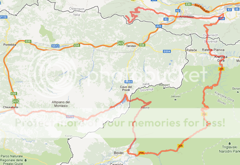
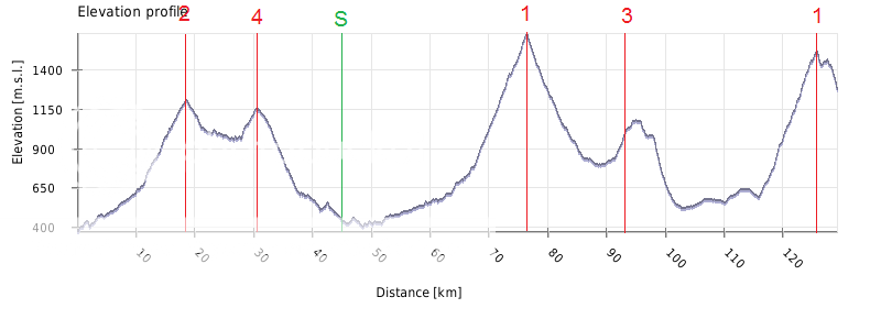
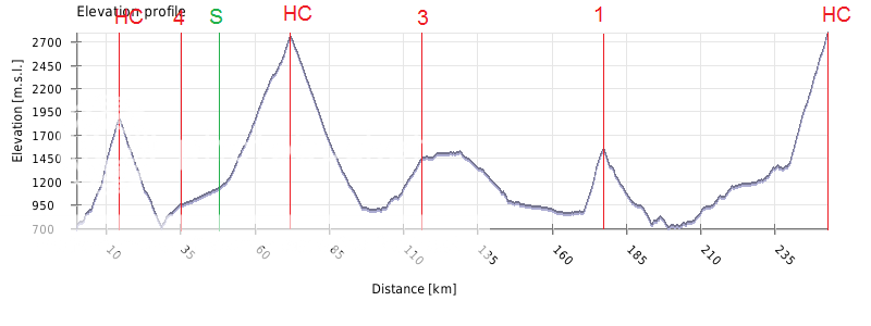
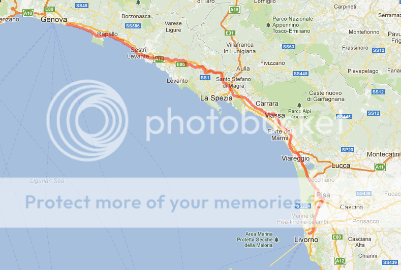
Stage 14: Málaga - El Peñón de Gibraltar, 184km

351irm1.png


2d8p820.png


Climbs:
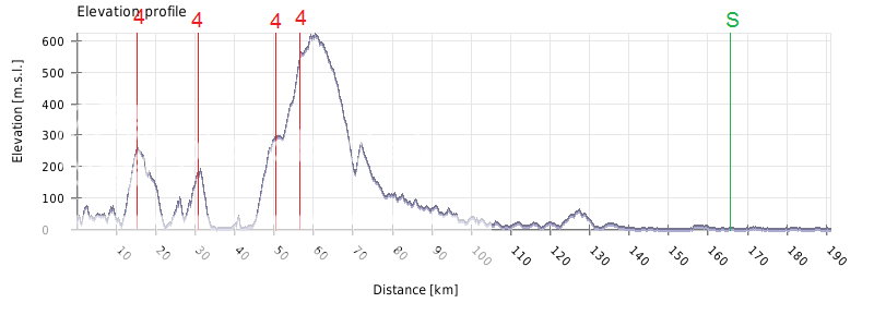
Alto de Mijas (cat.2) 5,0km @ 7,1%
Alto de la Mailena (cat.3) 7,2km @ 4,4%
Los Altos de los Monteros (cat.3) 3,6km @ 7,0%
Alto de Casares (cat.3) 5,7km @ 4,8%
Gibraltar (Top Station Complex)(MTF) 3,2km @ 10,3%

I hesitated over this but eventually decided that I would have to give this MTF points. It's worth it. Yes, after three stages which don't even touch the Iberian peninsula, my Vuelta leaves Spain for the first - and only - time, to go into the long-disputed and storied British territory that is the Rock of Gibraltar. There has been a cooling off of Anglo-Spanish arguments over the possession of the Rock in recent times, though co-authored plans for joint sovereignty have been rejected overwhelmingly by the Llanito population.

There was some excitement in 2010 as the Vuelta a Andalucía-Ruta del Sol announced a short time trial in Gibraltar, however this plan never came to fruition as some of the Gibraltarian companies whose money was being relied upon changed their minds and a somewhat longer time trial in Málaga. Nevertheless, that this was even a possibility is significant, and following on from that I've decided to bring La Vuelta to the people of the Rock. Chachi.

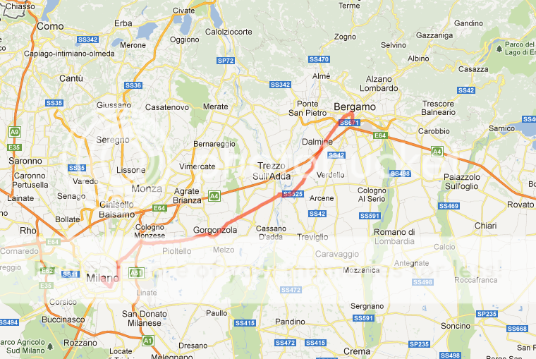
The stage starts in Málaga and winds its way down the Costa Del Sol, probably interrupting a lot of holidaymakers on its way. While much of the route is on flat coastal roads, and resultantly the biggest threat will be the wind and the heat, there are a number of small to medium climbs in the stage. The first of these is the toughest, as the riders wind their way up to the Alto de Mijas. Though its gradient and short-to-mid length may make you wonder what it's doing with the same categorisation as Conjuros, Santa Inés or some of the long gradual climbs in stage 11, a look at the first 5km of this profile shows you the climb and explains it - consecutive kilometres at 8,3, 8,7 and 9,3% respectively. After that it's two smaller climbs, the second of which leads us descending into Marbella.

After this, we have 40km of pan-flat, wind-vulnerable roads along the coast, with only the first intermediate sprint in Estepona to break things up. The next obstacle is the pretty gradual climb up to the mountain town of Casares. This shouldn't disrupt any but the worst of climbers, and then it's a mostly flat run in towards our dramatic finish. The second intermediate sprint takes place in 
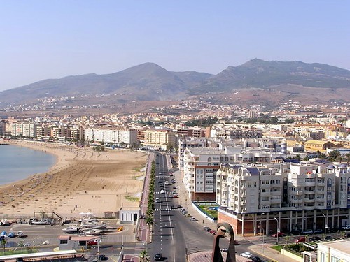
La Linea de la Concepción, which as you can see from the photo means that the riders will have an ominous view of Our Rock giving them a chaque of just what they have in store, especially as they get close to the border and the promontory's vertical scale becomes ever more clear.

Of course, crossing into Gibraltar means using one of the most unusual roads in the world, the highway crossing the runway at Gibraltar International Airport. Once on sovereign British soil, the riders will complete a brief loop of Gibraltar Town, so they can have a quick visua at some of the urban scenery and cobbled streets before the roads head to the sky for a dramatic finish at the Top Station Complex.

And then, se armó un zapatiesto. This stage is all about the final 3km. Why? Because they are brutal. Brutal, brutal, brutal. I found this account of a British amateur cyclist taking on El Peñón de Gibraltar, and I will reproduce a few of the key parts for your pleasure:

If I thought the first bit was steep, then this bit was twice as hard, and twice as steep! This road looked like a typical mountain road, but steeper. From the turnoff to the hairpin, it rises 105m!
Round the bend was a long straight which is about 14%. This was a relief, as the next 400m stretch was 20% up to another hairpin. Turning into the bend, panting, I looked up the next 300m of road, which was also 20%. The right hander was the beginning of the last and worst section. 600m, all at 25%.

Now, the route used there does not match exactly to mine; he has gone direct from sea level whereas my loop around Gibraltar Town has cut some of the start off. However, all of the key sections of destruction are there. After leaving the city gates and heading for the Upper Rock, the higher you go the more the roads become steep, narrow and dramatic, plus there's a perhaps entirely unique challenge - Barbary Macaques. The team cars and most equipment will stay in Gibraltar Town; this one will be motorbikes only, like only the worst of climbs. When they reach the finishing line, at the Top Station Complex of the Cable Car line to the top of the Rock, riders can return safely to sea level by using said Cable Car for safety reasons. After admiring the spectacular view, of course. Igor Antón, Joaquím Rodríguez and co are liking this one.

Málaga:
travel-guide-malaga-view-tr.jpg


El Peñón de Gibraltar (Top Station Complex):
5897365-Top_station_complex_Gibraltar.jpg
 
Jul 2, 2012
343
0
0
Visit site
Giro d' Italia Stage 13

Genova - Livorno (185km)

Three alpine stages and a long time trial were pretty hard, so lets give the riders a flat stage to catch their breath. There's a bunch of 4th category climbs at the beginning (to Rapallo 3,5km@6,5%; to Chiavari 3km@4%; to San Rocco 3,5km@7% and up Passo Del Bracco 4km@6,5%) but since its still 130km from the last climb to the finish, we should see a mass sprint. It will be interesting to see whether the peloton catches the break before the intermediate in Pisa. Now it might look like I painted myself into a corner here, but I still have something up my sleeve (and it's not that hard to guess actually).

Route:
route13.png

Profile:
profile13.png
 
Progsprach said:
Now it might look like I painted myself into a corner here, but I still have something up my sleeve (and it's not that hard to guess actually).
In Italy you can't paint yourself into a corner. Too many opportunities ;)
I see what is coming btw.
And, fyi, the "big" climb on this stage is the Passo Del Bracco. Easy, but quite famous.
 
Jul 2, 2012
343
0
0
Visit site
Giro d' Italia Stage 14

Bastia - Monte Cinto (186km)

Well, we already covered Middle Italy, but we still need to get down south so lets jump our way down on those conveniently placed islands. First up is Corsica and of course it's gonna be hilly. The riders first cross two cat. 3 clims to Murato (8,5km@4,5%) and to Luccine (5,5km@6,5%) and then another four cat.4 ascents (to Chiatra 3,5km@6,5%, Campi (4,5km@6%), Pianello (5,5km@5%) and St. Andrea-di-Bozzio (4km@6%) before the intermediate sprint in Corte. They then get a little easier terrain (around 30km) before the final ascent to Monte Cinto (12,5km@6%; cat.2).
BTW The difference between the lengtht in the profile relative to the given lenght is flat lenght vs. total road lenght.

Route:
route14-1.png

Profile:
profile14-1.png
 
Stage 15: Ceuta - Ceuta, 150km

ae9kkk.png


358ta8i.png


Climbs:
Mirador de García Aldave (cat.3) 5,5km @ 5,2%

You probably thought this was inevitable after the Melilla stage, and indeed you were right. To be honest, the Melilla stage was more or less because of this one. Travel from the mainland to Ceuta is a lot easier than to Melilla as the distance is lesser; from Gibraltar to Algeciras is only a short trip, then it's a quick ferry crossing for the riders to arrive back on the African continent for their second stage over here, and yet another first in this Vuelta of firsts, and the fourth (!) stage not to touch the Iberian mainland, after the two Balearic stages and the Melilla circuit race.

The city of Ceuta, on the African side of the Straits of Gibraltar, has been around since Roman times, but has been controlled by the Spanish since 1668, when it was formally handed over from Portugal (who had acquired it some 250 years earlier). When Spanish Morocco was returned to the Moroccans in 1956, however, Ceuta, like Melilla, was considered to be an integral part of the Spanish state, and so retained; its position of strategic importance and its being surrounded by mountainous terrain, thus providing some measure of protection, have kept it safe.

The territory of Ceuta is significantly larger (18,5km² in total) than that of Melilla, thanks to the surrounding mountains and the Monte Hacho peninsular outcrop. It was considered part of Cádiz province until 1995, when it became its own autonomous region. This larger size of the exclave allows for a more complex circuit race than the short flat loops in Melilla; here, the circuits are some 30km long, and thus we only have 5 laps to make.

The race starts and ends on parts of Calle de Martínez Catena. This is, no doubt long term followers of this thread may recall, very similar to my Vuelta a Ceuta one-day race right near the start; however there are some minor differences with this one, not least that while that was clockwise, this is anti-clockwise. This means that we aren't taking a short sharp dig up to the Fortaleza de Monte Hacho, instead it's a two-stepped gradual climb, and slightly steeper descent; not worth categorisation.

The riders then ride along the coastal north of the city, through the main city passages past the luxurious Parque Mediterraneo and the port before heading west to the village of Benzú. Here, the big challenge of the day begins; five times the riders will climb up into the hills, along the lines of several fortifications, past a number of towers (six in all), before crossing their highest point at the Mirador de García Aldave. The views down on the city from García Aldave are pretty stunning, but the riders won't really have much time to rest and admire them. Though fans might, as they'll be able to survey pretty much all of the day's action from the best seats in the house. As you can see from the profile, this isn't a super hard climb - 5,2% average gradient - but with a couple of stretches at up to 13% and some fairly wild inconsistency there is certainly scope for alterations.

The descent from García Aldave is mostly very fast and straight, however at the end there are a few technical corners to complicate things before the riders arrive back on the coastal roads and finish on the seafront as they started. Given that the riders will be circling this five times, this is a medium-moutain kind of day, and I feel that after the brutal gradients in Gibraltar and with the rest day to follow as the race caravan travels back across the Straits into Andalucía, this is likely to be a stage for a breakaway. However, the final cresting of the climb comes just inside 10km to go, so a bit of action from the GC contenders, knowing that refill day is just around the corner, may be a possibility as well.

Ceuta:
ceuta-01.jpg

(you can see where we're finishing on the left hand side of the isthmus here)

fje079.png

(run-in toward the finish)