I just have to point out that the Scandinavian tour uses a lot of gravel roads. Nipfjällets last 4 k is a gravel road+the bumpy roads before Hovfjället also is on very smal narrow gravel roads (probably in bad condition) and also on the stage between Vinstra and Lillehammer after Kilevegen (great climb btw) until you reach rv 254, i would be very surprised if not much of that area is on gravel roads except when the rout passes Kvitfjell.

Race Design Thread
Page 62 - Get up to date with the latest news, scores & standings from the Cycling News Community.
You are using an out of date browser. It may not display this or other websites correctly.
You should upgrade or use an alternative browser.
You should upgrade or use an alternative browser.
- Dec 16, 2011
- 345
- 0
- 0
Bubban said:I just have to point out that the Scandinavian tour uses a lot of gravel roads. Nipfjällets last 4 k is a gravel road+the bumpy roads before Hovfjället also is on very smal narrow gravel roads (probably in bad condition) and also on the stage between Vinstra and Lillehammer after Kilevegen (great climb btw) until you reach rv 254, i would be very surprised if not much of that area is on gravel roads except when the rout passes Kvitfjell.
I was already a little uncertain about that. Regarding the Swedish climbs: Streetview showed roads covered with snow, so it was hard to determine the condition of these. But based on the fact that you coulds see pictures of large touringcars at the top I decided that they are propably suitable for bike racing.
Regarding the Lillehammer stage: You're propably right, since these roads didn't even had Streetview. I will change it. Luckily I can keep the local rounds untouched, so it should still be an entertaining stage.
[Stages 1 - 5]
[Stages 6 - 10]
Tour de France Stage 11: Bordeaux - Mont-de-Marsan 184km
Flat stage via the coast
Tour de France Stage 12: Mont-de-Marsan - Artzamendi 149km
Flat all the way as they head south for the finish, and only climb of a day. A relatively easy day ahead of a very tough stage tomorrow, but the gradients at the top are enough to create gaps.
149km Artzamendi 10.4km @ 8.4%
An alternative finish for this stage would be the ramp at Ibardin, or if you're crazy, Larrun.
Tour de France Stage 13: Hendaye - Larrau 253km

A quiet start as they cross over into Spain, but back into France they go for a terrible final 100km.
50km Puerto de Velate 14.7km @ 4.7%
153km Col d'Arnosteguy 9.0km @ 9.1%
178km Artaburu 8.0km @ 10.2%
215km Col de Landerre 8.7km @ 8.7%
243km Bostmendieta 10.8km @ 7.5%
Does anyone know the final climb? It's SW from Alcay, coming out just a few km west of Larrau.
Tour de France Stage 14: Pau - Bagneres-du-Luchon 158km
Same towns but no Aubisque/Tourmalet/Aspin/Peyresourde. This is a flat stage, heading East but avoiding the dreaded climbs.
Tour de France Stage 15: Bagneres-de-Luchon - Foix 227km

Today we give Péguère a chance for redemption.
10km Col du Portillon 8.0km @ 8.0%
47km Col de Mente 9.3km @ 9.1%
63km Col de Portet d'Aspet 4.3km @ 10.0%
129km Col de Latrape 5.9km @ 7.2%
157km Col d'Agnes 10.2km @ 8.1%
176km Col de Portel 9.7km @ 7.7%
202km Col de Peguere 9.8km @ 7.4%
[Stages 6 - 10]
Tour de France Stage 11: Bordeaux - Mont-de-Marsan 184km
Flat stage via the coast
Tour de France Stage 12: Mont-de-Marsan - Artzamendi 149km
Flat all the way as they head south for the finish, and only climb of a day. A relatively easy day ahead of a very tough stage tomorrow, but the gradients at the top are enough to create gaps.
149km Artzamendi 10.4km @ 8.4%
An alternative finish for this stage would be the ramp at Ibardin, or if you're crazy, Larrun.
Tour de France Stage 13: Hendaye - Larrau 253km
A quiet start as they cross over into Spain, but back into France they go for a terrible final 100km.
50km Puerto de Velate 14.7km @ 4.7%
153km Col d'Arnosteguy 9.0km @ 9.1%
178km Artaburu 8.0km @ 10.2%
215km Col de Landerre 8.7km @ 8.7%
243km Bostmendieta 10.8km @ 7.5%
Does anyone know the final climb? It's SW from Alcay, coming out just a few km west of Larrau.
Tour de France Stage 14: Pau - Bagneres-du-Luchon 158km
Same towns but no Aubisque/Tourmalet/Aspin/Peyresourde. This is a flat stage, heading East but avoiding the dreaded climbs.
Tour de France Stage 15: Bagneres-de-Luchon - Foix 227km
Today we give Péguère a chance for redemption.
10km Col du Portillon 8.0km @ 8.0%
47km Col de Mente 9.3km @ 9.1%
63km Col de Portet d'Aspet 4.3km @ 10.0%
129km Col de Latrape 5.9km @ 7.2%
157km Col d'Agnes 10.2km @ 8.1%
176km Col de Portel 9.7km @ 7.7%
202km Col de Peguere 9.8km @ 7.4%
Tour de France Stage 16: Carcassonne - Lodeve 229km
A typical Tour stage here would be flat to Montpellier, not this time. Up and down and technical all day long.

Final 36km

82km 7.6km @ 6.1%
118km 12km @ 6.4%
172km 7.8km @ 6.5%
197km 4km @ 7.2%
211km 3.6km @ 7.6%
225km 2.9km @ 8.4%
Tour de France Stage 17: Ales ITT 49.4km

6.8km @ 4.4%
7.0km @ 5.7%
Rest Day 2: Ales - Avignon Transfer
Tour de France Stage 18: Avignon - Grenoble 239km
Today we celebrate everything that is good about sprinting...umm. As the final sprint stage they get major highways all the way.
A typical Tour stage here would be flat to Montpellier, not this time. Up and down and technical all day long.
Final 36km
82km 7.6km @ 6.1%
118km 12km @ 6.4%
172km 7.8km @ 6.5%
197km 4km @ 7.2%
211km 3.6km @ 7.6%
225km 2.9km @ 8.4%
Tour de France Stage 17: Ales ITT 49.4km
6.8km @ 4.4%
7.0km @ 5.7%
Rest Day 2: Ales - Avignon Transfer
Tour de France Stage 18: Avignon - Grenoble 239km
Today we celebrate everything that is good about sprinting...umm. As the final sprint stage they get major highways all the way.
Another_Dutch_Guy said:I was already a little uncertain about that. Regarding the Swedish climbs: Streetview showed roads covered with snow, so it was hard to determine the condition of these. But based on the fact that you coulds see pictures of large touringcars at the top I decided that they are propably suitable for bike racing.
Regarding the Lillehammer stage: You're propably right, since these roads didn't even had Streetview. I will change it. Luckily I can keep the local rounds untouched, so it should still be an entertaining stage.
I think you should change the race from a 2 week race to a full grand tour instead but still have the logical format of wisiting all capitals+ avoid going so far north in Sweden. You have Hovfjell and Tossebergsklätten around Torsby + Sälen and Trysil(Fageråsen) + the hilly area around Lillehammer(+Hafjell) already without going that far north. Stockholm-Copenhagen-Oslo means you can wisit Norway 2 times and give the riders a harder first part of the race.
Another possibility is Copenhagen-Stockholm-Oslo. That route will give you the chance to have ha Mountain stage for example around Lillehammer (but there is also mountains on the west side of Oslo, not as good as the area around Bergen but still) on the first Weekend.
A 3 week race also gives you the possibility to use hilly and populated areas such as Drammen and the area between Stavanger and Oslo. (Flekkefjord- Have a look on a little place called Sira and the roades on both sides if you wanna go all Zomegnan on us).
- Dec 16, 2011
- 345
- 0
- 0
You're really informed about the Scandinavian Area! I've visited Oslo once, but that's my only experience over there.
I've taken your advices seriously and have adjusted stage 3 and 13. Stage 3 is now on rather flat and proper roads until the final climb. For stage 13 I've rewritten the whole run-up from Vinstra to Lillehammer. The new route brings the riders over the famous Peer Gynt Vegen, and another climb nearby Tretten. Since steetview says that the Hipfjallet is a pretty good road this means that only the 12th stage to Dalsnibba still uses some 'bad' roads. Overall, I believe this has now become a fairly realistic version of a possible Scandinavia Tour.
Three weeks could be an idea. Maybe you can give it a shot?
- Jun 7, 2010
- 19,196
- 3,092
- 28,180
Another_Dutch_Guy said:You're really informed about the Scandinavian Area! I've visited Oslo once, but that's my only experience over there.
I've taken your advices seriously and have adjusted stage 3 and 13. Stage 3 is now on rather flat and proper roads until the final climb. For stage 13 I've rewritten the whole run-up from Vinstra to Lillehammer. The new route brings the riders over the famous Peer Gynt Vegen, and another climb nearby Tretten. Since steetview says that the Hipfjallet is a pretty good road this means that only the 12th stage to Dalsnibba still uses some 'bad' roads. Overall, I believe this has now become a fairly realistic version of a possible Scandinavia Tour.
Three weeks could be an idea. Maybe you can give it a shot?
Actually you inspired me to post some tours in Scandinavia so i have created two. One starting in Stockholm the other one starting in Copenhagen but this one doesn`t pay a visit to Stockholm but instead Gothenburg. The Stockholm-Copenhagen-Oslo route only has a parade in Oslo so i guess Libertine would wote for the Copenhagen start wich uses Holmenkollen and gjøkbakken on the last day
")
- Feb 20, 2010
- 33,248
- 15,774
- 28,180
Ferminal said:Does anyone know the final climb? It's SW from Alcay, coming out just a few km west of Larrau.
Here's a map of the routes up to the Col de Bosmendieta, better known by its Basque name of Bostmendieta (meaning "five mountains").

Here's the profile:

I'm pretty much certain this is your man.
- Sep 2, 2011
- 17,681
- 14,059
- 28,180
Tour of Java - Stage 6
Tasikmalaya - Tegal, 188,6 Km


Climbs:
Purwasari (Cat. 3) - 8 Km @ 3,5 %
After two difficult stage (ITT & MTF) let's see if sprinters can get a day of glory. Course is fairly easy, with some hills in the first 70 kms of the stage. None of them could cause serious damage though, the hardest being an 8 km false flat bringing the peloton to Purwasari.
Even the descent is nothing scary, with no turn and mild gradients. Last 75 kms are a huge pancake making it almost impossible for the daily break to take it to the finish line.
Tasikmalaya
Tasikmalaya - Tegal, 188,6 Km
Climbs:
Purwasari (Cat. 3) - 8 Km @ 3,5 %
After two difficult stage (ITT & MTF) let's see if sprinters can get a day of glory. Course is fairly easy, with some hills in the first 70 kms of the stage. None of them could cause serious damage though, the hardest being an 8 km false flat bringing the peloton to Purwasari.
Even the descent is nothing scary, with no turn and mild gradients. Last 75 kms are a huge pancake making it almost impossible for the daily break to take it to the finish line.
Tasikmalaya
- Dec 16, 2011
- 345
- 0
- 0
Bubban said:Actually you inspired me to post some tours in Scandinavia so i have created two. One starting in Stockholm the other one starting in Copenhagen but this one doesn`t pay a visit to Stockholm but instead Gothenburg. The Stockholm-Copenhagen-Oslo route only has a parade in Oslo so i guess Libertine would wote for the Copenhagen start wich uses Holmenkollen and gjøkbakken on the last day
Cool! I'm looking forward to see them.
- Sep 2, 2011
- 17,681
- 14,059
- 28,180
Tour of Java - Stage 7
Cirebon - Gunung Slamet (MTF), 213 Km


Climbs:
Km 55 (Cat. 1) - 5,7 Km @ 8,5 %
Km 63 (Cat. 3) - 2,8 Km @ 5,8 %
Km 73 (Cat. 2) - 3 Km @ 7,8 %
Km 94 (Cat. 1) - 8 Km @ 6,2 %
Km 130 (Cat. 2) - 3,7 Km @ 7,3 %
Km 151 (Cat. 2) - 7,6 @ 5,4%
Km 184 (Cat. 1) - 10,9 @ 7,7 %
Km 203 (Cat. 1) - 9,5 @ 5,7 %
Coming from a transfer stage, riders will be rested enough to give fans the thrill they deserve for a day like this. Eight rated climbs and a total gain of 4500 metres in a lenghty stage, there might be huge shakes in the GC.
Leaving from the coastal town of Cirebon, we approach the central part of the island. First 55 kms are mostly flat. After that, stage hunters and KoM contenders will certainly break away on the first climb of the day, a stiff 6 km ascent with slopes at 15%. Some 45 kms of ups and downs will follow, leading the group to the Dayeuh Luhur area. We then take it easy for about 40 kms, climb other two Second Category climbs and finally have a clear view of our daily special: Gunung Slamet.
Standing at 3,432 metres, it's the second highest volcano of Java. Unfortunately every feasbile road will take you nowhere near the summit and its 4 marvelous craters. Best way to access it is from northwest, climbing to Bumijawa (first 4 kms fairly easy, last 7 steadily at 10%), then descending to Bojongm turning right and starting the 9,5 km ascent to Slamet.
Mount Slamet

Cirebon - Gunung Slamet (MTF), 213 Km
Climbs:
Km 55 (Cat. 1) - 5,7 Km @ 8,5 %
Km 63 (Cat. 3) - 2,8 Km @ 5,8 %
Km 73 (Cat. 2) - 3 Km @ 7,8 %
Km 94 (Cat. 1) - 8 Km @ 6,2 %
Km 130 (Cat. 2) - 3,7 Km @ 7,3 %
Km 151 (Cat. 2) - 7,6 @ 5,4%
Km 184 (Cat. 1) - 10,9 @ 7,7 %
Km 203 (Cat. 1) - 9,5 @ 5,7 %
Coming from a transfer stage, riders will be rested enough to give fans the thrill they deserve for a day like this. Eight rated climbs and a total gain of 4500 metres in a lenghty stage, there might be huge shakes in the GC.
Leaving from the coastal town of Cirebon, we approach the central part of the island. First 55 kms are mostly flat. After that, stage hunters and KoM contenders will certainly break away on the first climb of the day, a stiff 6 km ascent with slopes at 15%. Some 45 kms of ups and downs will follow, leading the group to the Dayeuh Luhur area. We then take it easy for about 40 kms, climb other two Second Category climbs and finally have a clear view of our daily special: Gunung Slamet.
Standing at 3,432 metres, it's the second highest volcano of Java. Unfortunately every feasbile road will take you nowhere near the summit and its 4 marvelous craters. Best way to access it is from northwest, climbing to Bumijawa (first 4 kms fairly easy, last 7 steadily at 10%), then descending to Bojongm turning right and starting the 9,5 km ascent to Slamet.
Mount Slamet
- Feb 20, 2010
- 33,248
- 15,774
- 28,180
- Sep 2, 2011
- 17,681
- 14,059
- 28,180
- Oct 5, 2010
- 4,338
- 389
- 16,180
I'd absolutely LOVE to see a GT-like race in Scandinavia, but being realistic, in no way is it going to be able to compete with the other GTs. I really think it shouldn't be much longer than two weeks either, maybe 12 days is optimal... and since the roads have to be open for use, the race has to take place in summer. Maybe this should be in July, running parallel to the Tour? Or from mid-August so it overlaps into the Vuelta?
- Sep 2, 2011
- 17,681
- 14,059
- 28,180
Tour of Java - Stage 8
Purwokerto - Purwokerto, 156,7 Km


Climb:
Km 10-62-115 (Cat. 2) - 5 Km @ 8%
After the storm and before the rest day, we get a loop around the city of Purwokerto. It's a very short stage, likely the shortest of the Tour, suited to fast men who can survive small climbs.
Last bump is some 15 kms far from the finish.
Sagan time.
Then rest.
Purwokerto - Purwokerto, 156,7 Km
Climb:
Km 10-62-115 (Cat. 2) - 5 Km @ 8%
After the storm and before the rest day, we get a loop around the city of Purwokerto. It's a very short stage, likely the shortest of the Tour, suited to fast men who can survive small climbs.
Last bump is some 15 kms far from the finish.
Sagan time.
Then rest.
roundabout said:That's a neat stage 16, Ferminal.
Thanks, I never realised it was so hilly around there. Saved my route too as it would have been another flat stage (or long transfer).
Libertine Seguros said:Here's a map of the routes up to the Col de Bosmendieta, better known by its Basque name of Bostmendieta (meaning "five mountains").
I'm pretty much certain this is your man.
That's the one, much appreciated.
Tour of Australia - Stage 1
We start things off in Australia's 5th largest city, Adelaide. An 18km timetrial, starting at the University of Adelaide's Waite campus. A hill 2.8km in, 2.75km at 7.6% should provide the pure climbers some chances to limit their losses. The second half into downtown Adelaide is flat and straight, with the finish at the lovely Victoria Square.


We start things off in Australia's 5th largest city, Adelaide. An 18km timetrial, starting at the University of Adelaide's Waite campus. A hill 2.8km in, 2.75km at 7.6% should provide the pure climbers some chances to limit their losses. The second half into downtown Adelaide is flat and straight, with the finish at the lovely Victoria Square.
Tour of Australia - Stage 2
Stage 2 sees the riders begin where they finished yesterday, downtown Adelaide. Beginning in the botanical gardens, riders pass some lovely landmarks, such as the State Library and Adelaide oval before we turn north-east and head for the Adelaide hills. From about the 20km mark we hit the hills, passing some lovely waterfalls, reservoirsand conservation areas. After several small climbs and 158km, we arrive at the HTF at Mt. Lofty.
Climbs
20.24km, 4.58km at 5.0%
53.66km, 2.07km at 6.8%
81.70km, 4.91km at 7.0%
108.61km, 7.02km at 6.3%
124.84km, 3.35km at 6.0%
and Mt Lofty finish, 7.3km at 6.4%
Tour of Yemen - 13
Stage 13: Hajjah - Bayt Adh Dhi'b; 184 km
There are 3 climbs in this stage, but as you can see it is constantly up and down. This time there are two elements which make this stage so hard. 110 km of climbing and average elevation about 2000 m.a.s.l. (with finish in 3180 m.a.s.l.). Climbs in this stage aren't that much steep as in previous mountain stages, but they doesn't have to be to create differences (I didn't want the GC to be decided after ITT on wednesday).
Start is located far from any noticeable towns so they get to the official start town after 27 km of racing and more than1 000 meters of climbing. This first climbto Hajjah has some steeper part (namely 6 km with 11% average), but is still far from finish. Hajjah has somenice architecture and riders will make a loop around it with length almost 10 km.
Hajjah is located on the top of a mountain so logically desccent to valley follows. It's 15 km long and peloton will get under 1000 meters for the second time. Now they have tough task before them, to climb the Bayt Adh Dhi'b climb topping at over 3180 m.a.s.l. it is the highest point of whole Tour of Yemen. Luckily they have more than 40 km to do this, but will suffer nevertheless. Surface isgoodhere. On their way they'll go past another nice town - Kuhlan. As riders climb up the scenery dramatically changes from dry mountains and valleysto dry plateau.
After short flat section we're going down, back to Hajjah to climb this beast once again. This descent is 47 km long, but contains some ascents too.
Climbs:
Hajjah (27) - 25 km; 5%
Bayt Adh Dhi'b (85, 184) - 41 km; 5,5%
- Dec 16, 2011
- 345
- 0
- 0
Another_Dutch_Guy said:41 Km of climbing!
Really like the tour of Yemen. How is the condition of the roads you use?
Well, it's much better than in Eritrea for sure. I was surprised how many tarmac roads there are (and quite smooth by the looks of it). However if you take into acount that they have population over 25 000 000, then it may not be that surprising, they needed the roads mainly in the west part where is situated most of the population. In the east it is worse, there are basically two roads, one along the coast (which I used in the first few stages) and one through the desert. Form the roads I used only very few of them weren't paved, but even then they looked like in good condition and rideable.
- Mar 10, 2009
- 4,707
- 47
- 15,530
Tour of Greece Stage 2 - 184km: Neos Marmaras - Thessaloniki
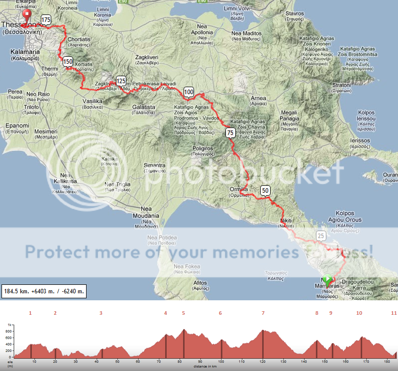
Categorized climbs (click for a photo impression of the climb):
(1) Cat. 2 8.0km, 4.8%
(2) Cat. 3 2.9km, 5.1%
(3) Cat. 3 2.5km, 6.5%
(4) Cat. 1 13.2km, 4.7%
(5) Cat. 3 4.0km, 6.9%
(6) Cat. 4 2.3km, 3.0%
(7) Cat. 2 6.6km, 5.7%
(8) Cat. 2 6.8km, 5.9%
(9) Cat. 3 2.3km, 8.0%
(10) Cat. 2 8.9km, 4.9%
(11) Cat. 4 2.0km, 5.0%
Stage 2 of the Tour of Greece is a brutal stage between Neos and Thesaloniki. With more than 6000 meters of height difference and 11 categorized climbs, only the strongest and fittest riders will survive and battle for victory. Although the mountains in the middle of the stage are the most demanding, there is no climb that outweighs all the others, giving riders the opportunity to attack on different occasions.
The riders start in the city of Neos Marmaras, a touristic seashore town with some 20,000 inhabitants. Picture 1 Picture 2. Immediately the road goes uphill, for the first of 4 category 2 climbs. Via the village of Parthenonas, the riders reach the top situated some 400 meter above sea level. After staying at that altitude for a while, the downhill is steep, technical and small, maybe the scariest part of this stage.
Disregard km 24 till 40, that is a non-asphalted road, I made a mistake there and should've taken the road next to it. Doesn't matter for gradients and such, so I feel reluctant to change it after it took me ages to make this profile.
A relatively flat section brings the riders to Nikiti, where the road goes uphill again for the third climb of the day, and staying there for a while again.

After the descent, the riders arrive in the finish place of yesterday, Ormilia, where they immediately start the climb to Vrastama, the only first category climb of the day. After a short descent, the 5th climb, of second category, follows, leading towards Taxiarchis, home to this beautiful church.
After a short and easy descent, the road climbs again, starting from Paleochora. It is an easy and short climb, after which the riders can rest a bit, before starting the next climb for real again in Petrokerasa. This is maybe the hardest climb of the day. The average percentage is not that big, but considering the fact that there is a large flat portion in the climb, the rest of the 7th climb of the day will surely be demanding.
After a scenic descent, the riders arrive in Lakkia, a little village at the foot of the next climb, of 8km (5.9%). The downhill is again breathtaking, with a view on a dam and , on the other side, Thessaloniki and the sea.

Bypassing Panorama, the riders have to conquer the last hills before the finish line. In winter and spring, snow is everywhere, even on the roads (see picture of climb 10). The views are glorious though.
After arriving at the top near Exochi, the riders can finally start the final descent towards the finish place and second city of Greece, Thessaloniki.
In Thessaloniki, the riders will face a final hill to the finish line, a short 4th category hill. After a day like today, even a 2km, 5% climb will hurt and, if it all comes down to a select sprint, the strongest rider has the chance to beat his opponents on the line in Sikies, a suburb of Thessaloniki.

Categorized climbs (click for a photo impression of the climb):
(1) Cat. 2 8.0km, 4.8%
(2) Cat. 3 2.9km, 5.1%
(3) Cat. 3 2.5km, 6.5%
(4) Cat. 1 13.2km, 4.7%
(5) Cat. 3 4.0km, 6.9%
(6) Cat. 4 2.3km, 3.0%
(7) Cat. 2 6.6km, 5.7%
(8) Cat. 2 6.8km, 5.9%
(9) Cat. 3 2.3km, 8.0%
(10) Cat. 2 8.9km, 4.9%
(11) Cat. 4 2.0km, 5.0%
Stage 2 of the Tour of Greece is a brutal stage between Neos and Thesaloniki. With more than 6000 meters of height difference and 11 categorized climbs, only the strongest and fittest riders will survive and battle for victory. Although the mountains in the middle of the stage are the most demanding, there is no climb that outweighs all the others, giving riders the opportunity to attack on different occasions.
The riders start in the city of Neos Marmaras, a touristic seashore town with some 20,000 inhabitants. Picture 1 Picture 2. Immediately the road goes uphill, for the first of 4 category 2 climbs. Via the village of Parthenonas, the riders reach the top situated some 400 meter above sea level. After staying at that altitude for a while, the downhill is steep, technical and small, maybe the scariest part of this stage.
Disregard km 24 till 40, that is a non-asphalted road, I made a mistake there and should've taken the road next to it. Doesn't matter for gradients and such, so I feel reluctant to change it after it took me ages to make this profile.
A relatively flat section brings the riders to Nikiti, where the road goes uphill again for the third climb of the day, and staying there for a while again.
After the descent, the riders arrive in the finish place of yesterday, Ormilia, where they immediately start the climb to Vrastama, the only first category climb of the day. After a short descent, the 5th climb, of second category, follows, leading towards Taxiarchis, home to this beautiful church.
After a short and easy descent, the road climbs again, starting from Paleochora. It is an easy and short climb, after which the riders can rest a bit, before starting the next climb for real again in Petrokerasa. This is maybe the hardest climb of the day. The average percentage is not that big, but considering the fact that there is a large flat portion in the climb, the rest of the 7th climb of the day will surely be demanding.
After a scenic descent, the riders arrive in Lakkia, a little village at the foot of the next climb, of 8km (5.9%). The downhill is again breathtaking, with a view on a dam and , on the other side, Thessaloniki and the sea.
Bypassing Panorama, the riders have to conquer the last hills before the finish line. In winter and spring, snow is everywhere, even on the roads (see picture of climb 10). The views are glorious though.
After arriving at the top near Exochi, the riders can finally start the final descent towards the finish place and second city of Greece, Thessaloniki.
In Thessaloniki, the riders will face a final hill to the finish line, a short 4th category hill. After a day like today, even a 2km, 5% climb will hurt and, if it all comes down to a select sprint, the strongest rider has the chance to beat his opponents on the line in Sikies, a suburb of Thessaloniki.
- Sep 2, 2011
- 17,681
- 14,059
- 28,180
Since tomorrow I'm leaving for India, I decided to take a break from my Tour of Java and postpone second and third weeks of the race to late August.
In the meanwhile I'll enjoy the crazy climbs of Ladakh and check if there's room for a stage race over there.
Keep up the good work everybody
In the meanwhile I'll enjoy the crazy climbs of Ladakh and check if there's room for a stage race over there.
Keep up the good work everybody
Tour of Australia - Stage 3
After the time trial and a hilly stage 2, the sprinters finally get a chance, and given the parcour, should definately pull back any break. Today is flat, as we travel the 198km from Murray Bridge to Bordertown with a vertical rise of about 100m.

After the time trial and a hilly stage 2, the sprinters finally get a chance, and given the parcour, should definately pull back any break. Today is flat, as we travel the 198km from Murray Bridge to Bordertown with a vertical rise of about 100m.
TRENDING THREADS
-
 Paris-Roubaix 2026, one day monument, April 12
- Started by Lequack
- Replies: 2K
-
 Itzulia Basque Country 2026, April 6-11
- Started by Dazed and Confused
- Replies: 2K
-

-
 Ronde van Vlaanderen 2026, monument, April 5 (men's)
- Started by Krzysztof_O
- Replies: 1K
-

-
 Teams & Riders The Remco Evenepoel is the next Eddy Merckx thread
- Started by DNP-Old
- Replies: 39K
-

Latest posts
-
-

-
Teams & Riders The Remco Evenepoel is the next Eddy Merckx thread
- Latest: ChasingPotatoes
-
-


Cyclingnews is part of Future plc, an international media group and leading digital publisher. Visit our corporate site.
© Future Publishing Limited Quay House, The Ambury, Bath BA1 1UA. All rights reserved. England and Wales company registration number 2008885.