• The Cycling News forum is looking to add some volunteer moderators with Red Rick's recent retirement. If you're interested in helping keep our discussions on track, send a direct message to @SHaines here on the forum, or use the Contact Us form to message the Community Team.

    In the meanwhile, please use the Report option if you see a post that doesn't fit within the forum rules.

    Thanks!

Race Design Thread

Page 168 - Get up to date with the latest news, scores & standings from the Cycling News Community.
Jun 30, 2014
7,060
2
0
Visit site
Re:

barmaher said:
Is there one of those for the Giro?

By the way, when drawing a Giro route, it is nearly impossible to resist the many hills that pepper Italy.

How the organisers managed to draw a course that allowed Ale-Jet to win 9 stages is unbelievable.
If you want to see the profiles of the Giro 2004 (when Petacchi won 9 stages) there is the official site still online http://www.gazzetta.it/Speciali/Giroditalia/2004/ita/le_tappe/
 
Stage 7: Hanau - Schlesingen, 226km

2wn2ow4.png


o0yplc.png


GPM:
Hutten (cat.3) 5,6km @ 4,3%
Wasserkuppe (cat.2) 7,9km @ 5,6%
Birxsteig (cat.3) 3,8km @ 6,3%
Hohe Geba (cat.3) 3,9km @ 7,1%
Rohrer Berg (cat.4) 2,6km @ 5,8%
Ruppberg (cat.3) 4,2km @ 5,6%
Grenzadler (cat.3) 4,1km @ 4,5%
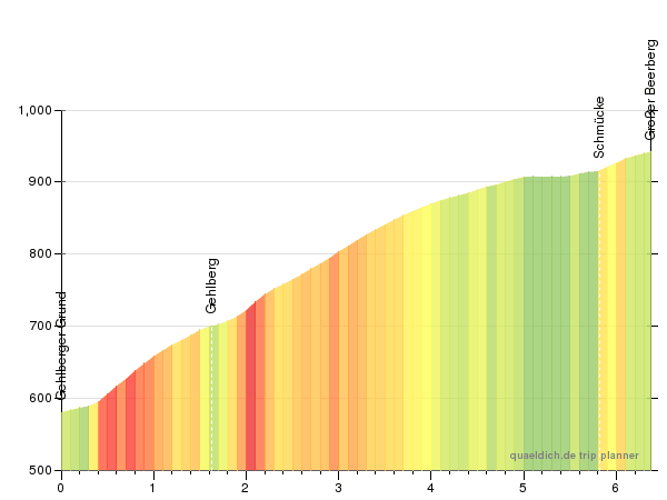
Großer Beerberg (Schmücke)(cat.2) 5,8km @ 5,9%

It's the Friday of week 1 in Germany, and it's been a long week, as though without any real serious mountains and under 20km against the clock the riders will have had to be attentive and fight throughout. Clausthal-Zellerfeld has been the only real stage for sprinters, though of course more durable ones could contest the Lüneburger Heide stage. There have been two cobbled stages, plus two different hilly stages which use their weapons in different ways. Now we move back east with another difficult intermediate stage which is tailor-made for a breakaway and will be a struggle for teams to control.

After the connection to the Brothers Grimm in the Winterberg stage, starting in Göttingen and going through Kassel, stage 7 continues the link to the legendary scholars, writers and archivists, who were born in Hanau, a town just to the east of the Frankfurt am Main conurbation. Like yesterday's stage finish the city is on the Rhein-Main-Verkehr local network so access will be easy for fans throughout the region. The first part of the stage, traversing eastern Hesse, is fairly straightforward, with only one fairly inconsequential climb in the first third of the stage. The first real test is Wasserkuppe, the highest peak in the Rhön mountains, popular with gliders and light aircraft and also with a small skiing area. The climb is a solid cat.2 with the last 4km averaging just under 8%; the record for many years was held by local rider Patrik Sinkewitz. Shortly after this we cross over into Thüringen via the climb into the village of Birx; I have erroneously labelled it "Birxsteig" by dint of association with the infamous climb at the Oberhof biathlon venue.

After this, you know what you're getting with the Thüringer Wald - lots of scenic forestry but lots of frustrating up and down. No gradients likely to create a Murito speciality zone, no climbs long enough for the endurance climbers to be favoured, but no respite. After the intermediate sprint in Zella-Mehlis with 55km to go, there are three climbs back to back, first the scenic Ruppberg, which is short-to-mid length and inconsistent, but backs absolutely directly into a climb which goes by the official name of Grenzadler, but crests at the legendary aforementioned DKB-Ski-Arena, the Oberhof biathlon arena which is arguably the most famous of all the venues for the sport. This climb is hardly steep (averaging 4,5%) though the last two kilometres are around 6%; straight off the back of the Ruppberg with no respite however we could see the break start to splinter here. The descent goes through the actual town of Oberhof with a fairly gradual but in its second half quite technical descent before the final climb, which crests with 25km remaining.

The Großer Beerberg is the highest peak in the Thüringer Wald, although the road that we are climbing does not go all the way to the top. The road actually passes slightly higher than we're going, passing between the Großer Beerberg and its neighbour, Schneekopf, however this road would only lead us back into Zella-Mehlis or Oberhof. Instead we're heading south by including all the steeper lower slopes of the climb but at the Waldgasthof of Schmücke we continue on to the south towards our finish.
490_548_gradient_600_450.gif


After this summit, the riders have a brief descent, about 5km flat, then around 8km of shallow descent before the rest of the stage is simply downhill false flat to the line in the town of Schleusingen, close to the border between Thüringen and Bayern. This is in some ways along the lines of the stage of the 2014 Tour that Tony Martin won on his long-range breakaway; here the climbs are easier, but they are also placed nearer the finish to make a sort of micro-version. Controlling this will be the key because a break could easily get out of sight and out of mind here, and groups could splinter. We could see anything from a complete GC shakedown to, if a team is strong enough and backs their guy enough to strangle those breakaways, the likes of Gerrans being interjected as a possibility.

Hanau:
1620389_1_32zh0138.jpg.0.jpg


Schleusingen:
87049_1_lightbox_georg1.jpg
 
Jun 30, 2014
7,060
2
0
Visit site
Libertine, I really like stage 7, that sstage could have many different possible outcomes and should be fun to watch.
I have designed a Vuelta Ciclista a Venezuela because the real one is too easy and has, at least for my taste, too many flat stages for the sprinters.
Right now don't have time to post the race, I'll start posting it in one or 2 weeks.
The race will have 10 stages like the real Vuelta a Venezuela, but it wil be a way harder race, hard climbs, am ITT of decent length, stages at high altitude and even a few hilly/medium mountain stages.
We won't visit Tachira, but we'll have more than enough climbing.
 
Jun 30, 2014
7,060
2
0
Visit site
Vuelta Ciclista a Venezuela stage 1: Mérida - Barinas
akecvj35x8c.png

ow96szcyzm4.png

Finally my Vuelta a venezuela starts and I choose to start the race in Mérida for a practical reason, the riders will be able to have training camps at high altitude in the area around Mérida, so they should be well prepared at the start of the Vuelta.
After the start only the first 13,4km are false flat, then the riders will already meet the first climb of the race and it's one hell of a long drag, they'll climb the Troncal 7 road until the reach Apartaderos, then they'll turn left and climb the final 2km of the climb until they ride past the stunning Laguna de Mucubají. The whole climb is 53,7km at 3,8%, it's a long drag with over 2000m of altitude gain, but mostly between 4 and 5% steep with a few sections of flat.
The now following descent would be the harder side of this climb, the final 29km are at 6,7% and, and ends with 27km to go. The final 27km are flat and on a large road and will bring the riders to Barinas.
This is just stage 1, so the climb is far away from the finish, but it should be hard enough to get rid of all the sprinters. The descent and the final 27km of flat will be interesting, will the sprinters be able to reach the main group or will the teams of the more well rounded riders that are also decent sprinters be able to set a pace that is high enough to keep them away. Some stagehunters could attack on the climb, but with the easy final they should get caught, so they'll probably just attack to give their teams and their sponsors some TV (or radio) time.
Mérida:
ciudad05-700x320.jpg

scaletowidth

Barinas:
01_Barinas,_estado_Barinas._Venezuela..jpg
 
Re:

Pricey_sky said:
Im thinking of designing a new race, but I need some inspiration and a country, maybe even several countries. Perhaps based in Africa or Asia where I have little knowledge and a blank canvas to start.

I always enjoy designing more if there is Street View coverage, it gives you idea of the road you use and the surroundings too. Italy has great coverage of unpaved roads for example, so that helps a lot when designing a race with sterrato. Even elsewhere when including unpaved road it's nice to check if it's actually rideable on a road bike.

That's why I liked designing in South Africa or Thailand. I haven't done anything in Japan, perhaps because it's so big, but also Taiwan looks like it has potential for some cruel stages (like we've seen in this thread after all).
 
Jun 30, 2014
7,060
2
0
Visit site
Volta a Venezuela Stage 2: Barinas- Boconó; 230km
js9qfayi5n6.png

5g9n3a1d36ga.png

The stage starts in Barinas, so the riders won't be forced endure a long bus ride after stage 1.
The first 130km are false flat, then the first tempogrinder starts, the Biscucuy-Boconó road, 36,1km at 3,8% with the final 9,6km at 5,8%. After the descent the riders will reachBoconó for the first time, then the 2nd tempogrinder starts, the Trujilo-Boconó road, 17,7km at 3,9%. After a hort descent we have a few km of rolling terrain, it's 5,1km at 4,4%, another short descent until we reach the final climb of the day, 2,8km at 10,4% with a few 14% steep sections on a nice unpaved road, without rain it shouldnt be a problem for the riders, with rain it could be really awesome.
On top of the climb we once again have a paved road, the final 6km are false flat and we'll reach Boconó once again.
Boconò is a nice town with over 50,000 inhabitants, the whole municipality has a population of nearly 80,000 inhabitants and ist mostly known for the beautiful hills that surround it, Simón Bolívar even called it El Jardín de Venezuela, the "Garden of Venezuela".
This could be a very interesting stage, if the 2 tempogrinders are raced hard enough we could see a few riders crack on the short steep climb. The final 6km are flat, so the riders that suffer on the steep final climb could come back and contest the sprint for the stage win.
This could be a stage for the breakaway, but given the fact that it's stage 2 and an early test for the gc rider, think about a Mende stage with 2 long gentle climbs before the final one it and 6km of false flat after the climb, it should be a pretty good stage.
he next stage will be the first real mountain stage and the only MTF of the race, the final climb is a real monster...
Boconó:
pho59960_iglesia-de-bocono-reconstrucion-total_H.jpg

Vista_de_la_ciudad_bocono_estado_trujillo.jpg

bocono.jpg
 
Jun 30, 2014
7,060
2
0
Visit site
Volta, a Venezuela Stage 3: Boconó – Collado del Cóndor; 171km
vjcohirjn1nd.png

w55ssczeji7.png

The first hard mountain stage and only MTF of the race, if you consider the altitute gain it's the hardest MTF that I've ever designed.
The stage starts in Boconó and after a short descent we have 10km of false flat before the climb between Boconó an Trujilo starts, 20.8km at 4%, a nice warm-up. After a few rolling km on top of the climb the descent that will bring the riders to Valera, the commercial center of Trujillo state, starts. 3Km after Valera the absurdly long and hard climb starts, Collado del Cóndor/Pico El Águila, 65km at 5,6%, over 3600m of altitude gain, and a MTF over 4100m above sea level.
We are talking about a climb that is harder than the iconic Colombian climb Letras, it's 18km shorter but has 400m of additional altitude gain. We can expect this stage to be total carnage, riders will loose a huge amount of time and the altitude gain will make this climb a nightmare for everyone.
The bronze statue of a condor at the top of the pass that commemorates when Simon Bolivar and his army of liberation passed the Andes in 1813, it's an awesome climb
I know that this one is really pushing the boundaries of what's possible, but the race starts in Mérida, so the riders should have the possibility to have their training camps before the Vuelta at high altitude. Still, this climb remains a real Monster and climbing it will be a real torture for most of the riders, but I think that the real Vuelta a Venezuela is too easy, so I've decided to make this one really hard. We will only have 3 high mountain stages, but those 3 will be hard enough to create decent gaps, I'm sure that Rujano and the Camargos would love this climb. :D
Collado del Cóndor:
Diciembre-2006-M%C3%A9rida-IV-082-710x533.jpg

colladodelcondor.jpg

9893260.jpg
 
My next race will be a Tour of Yorkshire. I thought this year was rubbish so here is a better one (in my mind!) that is four days (like next years) and wont have the french branding (like Tour de Yorkshire or Côte de Cow and Calf). This is better in my view so you can say your own opinions about it!
 
Jun 30, 2014
7,060
2
0
Visit site
Volta a Venezuela stage 4: Valera - Cabimas; 173,9km
2qhbv94hwt.png

d2c6e8meynme.png

After such a hard MTF we now have one of the few easy stages for the sprinters.
The stage starts in Valera and the first 110km should be pretty boring, durning the last 60km the riders will ride anlongside the coast line of theLago de Maracaibo, a large brackish bay, so maybe we could get some wind to spice things up.
The stage ends on Cabimas, a town mosty known for his lage port and the oil industry, just like the whole Lago de Maracaibo. Lake Maracaibo is also known for the catatumbo lightning, perhaps the most impressive lightning storms on earth, according to wikipedia they occur during 140 to 160 nights a year, 10 hours per day and with up to 280 lightning strikes per hour.
Valera:
VENEZUELA_-_Valera_Catedral.jpg

918433.jpg

Cabimas:
abvmtm-bg.jpg

Cabimas.jpg
 
Aug 21, 2015
380
0
0
Visit site
Finally finished mapping out my go at a TDF on here(I know, there have been plenty on here already. I'll try some different races after this when I get the time, possibly California). Still gotta tidy up some stuff with it but I'll start getting the stages pumped out here soon. No real theme for this race or anything like that, just my go at making a fun course and getting as much action into 21 stages as I can without going full Zomegnan or at least limiting that to a couple stages. There was a lot of areas I wish I could have gotten to but the hardest part about designing a TDF is not about what to put in but what to leave out. Won't go too much into it as to not give anything away but the Grand Depart will be from the beautiful St. Malo.

201306067_Etape-10_ville-arrivee_saint-malo.jpg
 
Jun 30, 2014
7,060
2
0
Visit site
Vuelta a Venezuela stage 5: Maracaibo ITT; 29km
epcvdrbu3a9j.png

rehxlzi7h3l.png

Today we have the only ITT of the race, not the longest one, but it's a medium length ITT for the specialists.
Maracaibo is the 2nd largest metropolitan area of Venezuela and is mostly known for his big port and the oil industry and it's also the hometown of the track cyclist Daniela Larreal.
The ITT starts on the Plaza de la República and durining the 2nd part of the ITT we ride past the Estadio Luis Aparicio de Maracaibo and finish in the Ciudad Universitaria, the university centre.
After todays stage the riders we'll have a long transfer to Santa Ana de Coro, but the riders will be able to use the local Airport and maybe the ITT could start a little bit earlier than usual, so it shouldn't be a problem
Maracaibo:
950px-MaracaiboView.jpg
 
Jun 30, 2014
7,060
2
0
Visit site
Vuelta a Venezuela stage 6: Santa Ana de Coro - Santa Cruz De Bucaral; 156km
tv7bkzmjt1z5.png

7een7geg7l99.png

After the ITT and a long transfer, fortunately both cities have an airport, a nice hilly stage.
The race starts in Coro, the capital of Falcón, a town known for his well preserved Colonial architecture.
This stage features a decent amount of climbing, over 3000m of altitude gain, and the descent of the cat 1 climb looks rather technical. I don't know the names of all those climbs, so I can't tell you a lot about them, they are all paved and the roads seem to be pretty good.
After the final climb we have a short decent, it's not a technical one, and only 4,6km of flase flat before we reach Santa Cruz De Bucaral, the capital of the municipality Unión.
I don't know how much of an impact this stage will have on the gc, the climbs are not that hard and the hardest climb ends 110km away from the finish line, but still, it's a nice hilly stage and it comes right after the ITT so we could see some attacks, if not it should still be an entertaining breakaway stage.
Santa Ana de Coro:
dbddc4f7b7f8553eaa5884cf2935f3a6.jpg

Visit-Coro-Falc%C3%B3n-State-Venezuela-651x367.jpg

Santa Cruz De Bucaral:
7633170.jpg
 
Re:

52520Andrew said:
Finally finished mapping out my go at a TDF on here(I know, there have been plenty on here already. I'll try some different races after this when I get the time, possibly California). Still gotta tidy up some stuff with it but I'll start getting the stages pumped out here soon. No real theme for this race or anything like that, just my go at making a fun course and getting as much action into 21 stages as I can without going full Zomegnan or at least limiting that to a couple stages. There was a lot of areas I wish I could have gotten to but the hardest part about designing a TDF is not about what to put in but what to leave out. Won't go too much into it as to not give anything away but the Grand Depart will be from the beautiful St. Malo.

saint-malo-07.jpg

Great! A new TdF course is always a delight. I have been messing with Cronoescalada for a while since I saw the icon on a design from Libertine Seguros (Fantasy Doping Draft) a while back. My TdF is in the works. To your "what to leave out?" point, for me, the objective is to leave out the same-old-same-old that we get fed every July.
 

TRENDING THREADS