• The Cycling News forum is looking to add some volunteer moderators with Red Rick's recent retirement. If you're interested in helping keep our discussions on track, send a direct message to @SHaines here on the forum, or use the Contact Us form to message the Community Team.

    In the meanwhile, please use the Report option if you see a post that doesn't fit within the forum rules.

    Thanks!

Race Design Thread

Page 169 - Get up to date with the latest news, scores & standings from the Cycling News Community.
Aug 21, 2015
380
0
0
Visit site
Re: Re:

Tonton said:
Great! A new TdF course is always a delight. I have been messing with Cronoescalada for a while since I saw the icon on a design from Libertine Seguros (Fantasy Doping Draft) a while back. My TdF is in the works. To your "what to leave out?" point, for me, the objective is to leave out the same-old-same-old that we get fed every July.

Thanks, look forward to seeing your design as well. I tried to include quite a few underused areas as well, couldn't get to everything as there are quite a few good areas to get into but you should have no problem finding some good roads.
 
Aug 2, 2015
71
0
0
Visit site
Re: Re:

52520Andrew said:
Tonton said:
Great! A new TdF course is always a delight. I have been messing with Cronoescalada for a while since I saw the icon on a design from Libertine Seguros (Fantasy Doping Draft) a while back. My TdF is in the works. To your "what to leave out?" point, for me, the objective is to leave out the same-old-same-old that we get fed every July.

Thanks, look forward to seeing your design as well. I tried to include quite a few underused areas as well, couldn't get to everything as there are quite a few good areas to get into but you should have no problem finding some good roads.
Look out. It is quite a problem. I'm checking France in streetview for more than a year and i've found a lot of flaws in their engineering idea. In their cities roads are often so narrow that a truck won't fit. That's fine, as the pre-XVIIIc. western architecture was very squeezed and almost all of the towns (even villages) are older. The problem is, that quite some number of these settlements don't have any truck roads and TdF doesn't like to smash through those narrow, often cobbled chemins in the downtown.

French roads have a tendency to have too much of the rond-points and road islands. Having road islands is good for the safety on the zebra, but often you can find those in completly remote and illogical locations on roads, that doesn't seem to be busy. The most extreme case i found is in Rennes. If i recall correctly the sinish line was mostly on the close to end of the Avenue Professeur Charles Foulon making it around 700m straight. It's more than enough for a theoretically safe TdF sprint (i think 300m straight is enough for TdF sprint stage). Sadly, in 2011 a road island was build for some enigmatic reasons in the most strategic place - middle of the straight and now this finish place is no longer usable.

I have a small tip that might be helpful. TdF seems to like finishing near stadiums.
 
I'm working on my first ever mapping project as far as stage racing goes. It's a Tour of the Baltics. It's proving to be quite difficult to create meaningful racing there, just like on a Tour of Denmark. The highest point in all three Baltic states are usually at about 300 metres above sea level. This is flatland for the most part. But we'll get some interesting racing anyway.
 
Ok. Here we go. This will be a mostly flat stage race, given that the the options are very limited in terms of terrain. There will be some potential epic stages though.

Tour of the Baltics Stage 1: Kaliningrad - Suwałki 221km
wxLy8pw.png

0VJs5cL.png


Funny enough, this first stage doesn't even pass through the any of the actual Baltic states. But the Kaliningrad Oblast was previously a part of East Prussia as Königsberg and historically a part of the Baltic region. We will end in the Polish town of Suwałki, which is a more definite step outside Baltic territory. However this town has been in Lithuanian hands before. Not only because of its history during the Polish-Lithuanian Commonwealth, but the town exchanged hands a few times in the 20th century as well when both Poland and Lithuania were resurrected from being partitioned between greater powers.

The stage starts at the very scenic Königsberg Cathederal. Also very close to the tomb of Immanuel Kant, one of our world's most important philosophers to date.
dW3ZJ8Q.jpg


The stage is mostly flat and will probably be won by a sprinter, despite the very narrow roads in the last 25km or so. On these narrow roads we also have our lone climb of the day (and one of only three categorized climbs
of the race), near Żywa Woda north of Suwałki. 1km at 4.5% doesn't sound difficult at all, but it has a section of 500m at 7%. At the very least it will probably create some more action than a straight run into town.

The finish is located on a long straight into town, finishing right near the St. Alexander Church in the center of town.

J9ZnqIY.jpg
 
Aug 21, 2015
380
0
0
Visit site
Re: Re:

dpm1991 said:
52520Andrew said:
Tonton said:
Great! A new TdF course is always a delight. I have been messing with Cronoescalada for a while since I saw the icon on a design from Libertine Seguros (Fantasy Doping Draft) a while back. My TdF is in the works. To your "what to leave out?" point, for me, the objective is to leave out the same-old-same-old that we get fed every July.

Thanks, look forward to seeing your design as well. I tried to include quite a few underused areas as well, couldn't get to everything as there are quite a few good areas to get into but you should have no problem finding some good roads.
Look out. It is quite a problem. I'm checking France in streetview for more than a year and i've found a lot of flaws in their engineering idea. In their cities roads are often so narrow that a truck won't fit. That's fine, as the pre-XVIIIc. western architecture was very squeezed and almost all of the towns (even villages) are older. The problem is, that quite some number of these settlements don't have any truck roads and TdF doesn't like to smash through those narrow, often cobbled chemins in the downtown.

French roads have a tendency to have too much of the rond-points and road islands. Having road islands is good for the safety on the zebra, but often you can find those in completly remote and illogical locations on roads, that doesn't seem to be busy. The most extreme case i found is in Rennes. If i recall correctly the sinish line was mostly on the close to end of the Avenue Professeur Charles Foulon making it around 700m straight. It's more than enough for a theoretically safe TdF sprint (i think 300m straight is enough for TdF sprint stage). Sadly, in 2011 a road island was build for some enigmatic reasons in the most strategic place - middle of the straight and now this finish place is no longer usable.

I have a small tip that might be helpful. TdF seems to like finishing near stadiums.

Yeah always gotta double check the route when I put it in. I had it route me on some narrow roads a couple times although the bigger problem for me was that it kept putting me on big highways.
 
Tour of The Baltics Stage 2: Marijampolė - Vilnius 196km
cy4oBpl.png

XWN6fvF.png


To start this stage, we have transfered about 100km from the finish of the last stage. We begin in the town of Marijampolė, a town with rich history - especially Jewish history. We start near the city centre, with a view over the famous St. Michael's Small Basilica.
lGK5PFr.jpg


The road to Vilnius is fairly easy, no real difficulties. However the stage will end with a circuit (within UCI regulations) in central Vilnius, finishing in Vilnius Old Town. The circuit is about 5.2-5.3km long and has a 1km long cobbled stretch. The cobbles are of no significant difficulty though, they are about as difficult as the last sector of cobbles in Paris-Roubaix, the Espace Charles Crupelandt. The finish line is situated about in the middle of this cobbled section.

The circuit is not completely flat, but the small bumps that exist are probably too easy to create any gaps. The slight uphill finish makes this perfect for a rider like Degenkolb though.

The finishing circuit: (4 laps)
jaS2Jv4.png


Vilnius:
2.jpg


The finish:
56tIn2n.png
 
I'm going to be fairly quick with revealing this entire route, not this one stage a day BS. And it's time for a brutal stage. YOU ASKED FOR STERRATO? YOU WILL GET STERRATO!

Tour of The Baltics Stage 3: Kaunas - Plungė 225km
GG6fbeP.png

hxQsRLr.png


You can see something in the profile (excuse the uglyness of my sloppy ass MS Paint skills). Four long ass sectors of, you guessed it, gravel roads. All in all, this day has more than 100km of gravel road. This is going to be a long grueling stage. One might even think, is this even a stage worthy of being a road race? Well. This is road, isn't it? Road Race cycling doesn't have to be limited to asphalt. This is more of a war of attrition style of design than bursts of gravel sections like in Strade Bianche.

In this stage race, I have three categories for the difficulties of the gravel roads the riders will face. Just like in Paris-Roubaix I will use stars. One star for the mildest, three stars for the most difficult.

The sectors in this stage are as following:
Sector 4: Veliuona - Šimkaičiai (*) (25.0km)
Sector 3: Eržvilkas - Nemakščiai (**) (18.6km)
Sector 2: E77 - Varniai (*) (36km)
Sector 1: Žarėnai - Plungė(*) (26.1km)

One side note: Sector 2 could be divided up into two sections, because there is a stretch of a few hundred metres of poor asphalt in the middle of it passing through a small town. Still brutal no matter how you slice it.

Now on to the stage narration:

We start at the Vytautas monument in the centre of Kaunas. A very grand location for a start of the stage, and we come here after a 105km long transfer from the previous finish in Vilnius. We immediately head west, towards the coast, but not going all the way to the coast. We will follow big roads all the way to the first gravel sector.

Kaunas:
T1b0jnp.png


This Sector 4 comes after 65.6km into the stage, and is long but not relentless. It has its few bad spots here and there, but all in all the gravel section is wide and straight and you can go at it at high speed on a motorized vehicle without much difficulty. This sector is more about draining the energy of the riders on what will be a long and hard day.

Sector 4 glimpses:
jJ0MizU.png


The route now offers maybe 40 minutes of rest now before the next sector begins. This sector is the hardest of the day, and this is because the surface is much looser. The road is still wide and not very bumpy, but because of the looser gravel this gets a more difficult rating.

Sector 3 glimpses:
gXxEuvU.png


Not many km from the end of the previous sectors comes the feed zone. This is on a 14km stretch without gravel. So the riders can expect smooth surface for about 20-25 minutes. Then the longest sector will begin. Sector 2 is extremely long, but as mentioned before there is a small stretch of asphalt in the early middle part of it. It is very easy surface to ride on though, but expect the dust wind to firmly hit the riders here.

Sector 2 glimpses:
EuvOVMW.png


After that long sector the riders can expect fine asphalt for about 20km before the gravel commences. This sector starts with a mere 32km to the finish line and is also a long one at over 26km long. This sector has a few bumps in the road the riders will have to be cautious of, but for the most part the gravel is very fine and the road is for the most part fairly wide.

Sector 1 glimpses:
4VVuJuu.png


After that sector is finished the riders will see a 6km stretch into the finishing straight in the town of Plungė. The finish is on a pretty uninteresting straight next to a park on the main big road passing through town, but it will do. The riders will be too tired to notice any scenic places in the town anyway, and the run in was to be as short as possible from the end of the gravel sector to produce maximum carnage (we all like carnage).

Plungė:
PlungeDvaras.JPG
 
Tour of The Baltics Stage 4: Klaipėda - Ventspils 214km
JTcRZOT.png

WilWeMS.png

You want echelons? We might get them. Oh, and a dirt road at the end to mix things up a bit.

Sector 1:
P111-Cirpstene (**) (14.1km)

After a 60km transfer from the previous finish, we start in the important port town of Klaipėda.
apie_04.jpg


This stage moves along the coast most of the time, and can definitely create selections. However, large sections of the road are sheltered from the wind by forest. There will be some sections that look more like this though:
OdOPRrE.png

Here the crosswinds can be felt without a doubt. And the strong winds don't always necessarily come from the sea, some times they come from inland from where the road is less sheltered. This would really split up the bunch.

Towards the end of the stage the riders will also face the only sterrato sector of the day. The sector starts out easy, but gets progressively less maintained closer to the finish. A peak at the latter part of the sector:
XrYK2hV.png


Oh, and did I mention? Some parts of this dirt road lay completely exposed to the wind. Will make it way more difficult.

The finish area looks something like this, right next to the sea:
gKaChWt.png


Ventspils, the birth town of my grandmother, is one of the most important towns in Latvia, given its location as an ice-free port with great access to the seas.
uy8naIG.png
 
Tour of The Baltics Stage 5: Jūrmala - Rīga 23km (ITT)
tyymru5.png

oUXf9GH.png


Well. Time for an ITT. This is pancake flat. The only difficult section of this might be the last km or so, which is on light cobbles.

The start is close to the beaches of Jūrmala:
WaGh8D8.jpg


Cobbles:
AKpUFW6.jpg


The finish is near the Freedom Monmument in Rīga.
MovvgO6.jpg
 
This is the grand daddy stage. Especially if the weather turns sour, this will be an insane stage to watch. Coming off the back of a TT, there are guaranteed to be gaps going into this stage, and there's going to be gaps created on this stage, rest assured. This stage will have the toughest climb of the race as well as more than 60km of sterrato.

Stage 6: Cēsis - Suur Munamägi 194km
IgVkEbQ.png

O1wX8rE.png


To begin with, let me introduce the sectors:

Sector 7: Liepa - Lisa (*) (15.2km)
Sector 6: Variņi - P27 (*) (3.1km)
Sector 5: Sinole - Lejasciems (***) (8.1km)
Sector 4: Strautiņi - Alūksne (**) (12.4km)
Sector 3: Māriņkalns - E77 (*) (9.7km)
Sector 2: Murati - Ruusmäe (**) (7.4km)
Sector 1: Plaani - Haanja (***) (6.5km)

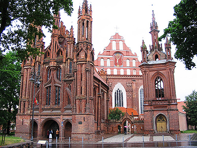
Now. The start is at the town of Cēsis, known for its role as a heavily fortified city because of its castle in many wars. To get here we have transfered 100km from Riga. Here's a picture of Cēsis with its castle in the bottom left.
Cesis.jpg


And away we go. We won't have to far to find our first sterrato section of the day. And it's actually the longest. Though there is a spot where it moves through a town where there is asphalt for a few hundred metres. This is probably the easiest sector of the day if we consider the road surface alone.

Sector 7:
5HNsTf4.png


The road is farily easy now up until the next sector. The next one starts after 66km and after having had about 35 of paved road inbetween the two sectors. This is also a very easy sector, and actually really short, but it's about there not being too much space between the sectors.

Sector 6:
EQqrP2T.png


We get back to the motorway after this sector. Unfortunately we have to stay here for 30km until the next sector. But it's worth the wait. This is going to be an exceptionally brutal sector. This is because about 5km of this sector is on what can pretty much only be deemed as tractor road. The beginning part is not to be disregarded, but pale in comparison to the latter half of the sector. The pictures will speak for themselves.

Sector 5:
IjYr9ft.png


Wow. Imagine that during a rainy day. At least the riders get a 30km break from any unpaved roads from this point forward. Now is where you have put your teammates up the road to wait for you after the sterrato sector to help you on the flat. The following 4 sectors are going to follow each other quite closely now, with little rest inbetween them. Starting with a two-starred story, earning its rating from its relatively bumpy surface.

Sector 4:
Eazy22K.png


After a few kilometers of rest comes the next sector. An easy one, comparable with the first of the day, yet nothing to frown upon.

Sector 3:
8Jkv5Kt.png


Another few kilometers of rest and away we go again. Sector 2 is slightly harder, because of slightly looser road surface. 7.4km of pure joy for the riders :). We also head into Estonia for our fourth and final border crossing of this stage race.

Sector 2:
VqLF4rh.png


The last sector is still to come. It starts out fairly easy, but the road turns sharply to the north and towards an extremely narrow and difficult section. The pictures will speak louder than my words.

Sector 1:
Za6BUnO.png

FVhCapL.png


Well. Now we only have about 1.5km left to the finish line. And if there is a group that comes out together from this sector, they will battle it out on the final climb. Here we will reach Estonia's highest point, with a water tower on the top. 450m @ 10.7% is not too bad of a finishing ramp. It's also one of three categorized hills of this entire race. Yay!

Suur Munamägi:
0808.jpeg
 
Might as well finish this off. I'd like some feedback too if I can get any. I know many people read this thread but don't normally reply.

Stage 7: Tartu - Tallinn 194km
NgzeMDT.png

HZERnkI.png


The finish is in the town of Tartu, located about 100km north of the previous stage finish.

We will start in and around the Old Town of Tartu.
tartu2.jpg


We will travel on pretty small roads most of the day, though they are asphalted today. This will just basically be a long travel into Tallinn. Here is where it gets interesting though. The Old Town in Tallin is located on a bit of a hill. And one of they ways to get up there is cobbled. The finish will be as stated in the profile, 400m at 6.3%. And it's cobbled. Here's what it looks like more or less:
5U8rkjG.png


Much more difficult than the finish in Vilnius. And we will end right by the Alexander Nevsky Cathederal.
AlexanderNevskyCathedral.jpg


Tallinn:
tallinn-air-1_AAl.jpg


So. That's it for this stage race. A shorter one-week one. Even though it's mostly flat, we're guaranteed to see better racing than just waiting for bunch sprints.

A conclusive map:
4DC5y8A.png

A total of 1270km of racing, including more than 175km of sterrato.
 
I did check out Kaunas before, but any circuit there with a finish actually inside town would be fairly weak.

Sigulda is interesting, didn't know about it. You can find a 800m stretch at 10%. That's almost unheard of in the flatland over there :D.

That wall in Viljandi I did not know about, but it's really fun. I find it difficult to create anything meaningful there as far as a lap goes though, because if you want to use the two roads that are actually steep in conjunction you would have to pass the exact same road twice (without possibility of doing on like WC courses where you put a fence through the middle of it). This is the best I can come up with:
1wJGVUZ.png


Which is an OK stage finish I guess. Michael Matthews FTW.

And by the way, why does cronoescalada remove the last few hundred metres of every map I create on the profile but not on the map? WTF IS UP WITH THAT. I MEAN, IT'S GREAT AND ALL BUT SOMETIMES THIS SITE JUST BUGS OUT COMPLETELY WTF. I had to use mapmyride for this instead now

Thing about the route I made, I wanted to visit most of the major cities in the region (and a stage finish in all the capitals), and not grotesque transfers like in this years Vuelta. Seeing these other options are great too, but not game-changing as to how racing can be done in this area of the world. The best thing in this race is sterrato anyway.
 
Re:

jsem94 said:
And by the way, why does cronoescalada remove the last few hundred metres of every map I create on the profile but not on the map? WTF IS UP WITH THAT. I MEAN, IT'S GREAT AND ALL BUT SOMETIMES THIS SITE JUST BUGS OUT COMPLETELY WTF. I had to use mapmyride for this instead now
It's happened to me: you need to hit show profile last, otherwise it may "forget" your last segment/click. Otherwise, I like both the course and the narrative.
 
I've almost finished my last project; another version of the Giro. Perhaps not the most original idea, but still it's definitely the country with most opportunities to create races with interesting routes.

- The Giro will start in Puglia, probably Taranto, and finish in Milano.
- There will probably be 6 medium or high MTF.
- Cima Coppi will be at 2130m
- The race will not go through Toscana, Liguria and Piemonte as in my last version, but through Emilia Romagna, Veneto and Friuli Venezia Giulia.

I will start posting in a few days. There are still some minor details to be sorted out.
 
AND NOW FOR SOMETHING COMPLETELY DIFFERENT


1bxi6pO.png


My idea for a World Championship route in Stockholm. My birth town. I love that city, and well, it's mostly flat and boring but there are a few ways to make a route interesting. Here we go. One thing is false in this profile though. That's the bridge of Västerbron. It doesn't get recognized as rising in altitude here, but I will fill you in anyway on the stats as we go along.

There are basically five things one could call bumps on this route. Two of them are barely noticeable but I'll mention them anyway, because why not, and they're all concentrated towards the end of the course. Here they are in more detail:

Igeldammsbacken (6.7km to go) - 270m @ 7.5%
Västerbron (4.9km to go) - 300m @ ~4.5%
Högalidsgatan (4km to go) - 210m @ 5.5%
Skinnarbacken (3.1km to go) - 200m @ 7.5%
Bastugatan - (1.4km to go) - 260m @ 8.9% (max 16% cobbled)

Breaking down this last climb a bit further:
- The first 55m are fairly steep, but it's hard to find an accurate figure on how steep this section is. Around 12% seems a reasonable guesstimate.
- The final 205m are cobbled.
- The last 110m are steeper than 12%, and the last 30m steeper than 15%.

And it's not just any cobbles... It looks a little bit like this:
cVjQhTp.png

RbiBgRN.jpg


1.4km later we have the finish will be near the statue of Gustav III on the Skeppsbron in Gamla Stan (Old Town):
1BQV0em.png


Stockholm:
stockholm.jpg


All in all, it's pretty much a slightly weaker route than Richmond.
 

TRENDING THREADS