• The Cycling News forum is looking to add some volunteer moderators with Red Rick's recent retirement. If you're interested in helping keep our discussions on track, send a direct message to @SHaines here on the forum, or use the Contact Us form to message the Community Team.

    In the meanwhile, please use the Report option if you see a post that doesn't fit within the forum rules.

    Thanks!

Race Design Thread

Page 171 - Get up to date with the latest news, scores & standings from the Cycling News Community.
Re:

52520Andrew said:
Cronoescalada moved the zoom and street view buttons!!!

They are now along the upper left side under the option to go to satellite or map mode. Still no zoom slider but really happy to see this at least as it makes it a lot easier to go through stuff on my lap top.
And they added a "avoid highways" button. That makes it so much better.
 
Re: Re:

Gigs_98 said:
Valv.Piti said:
fauniera: I find a Giro 100x more interesting than some stage race in the UK. Keep it up, I'll follow it for sure.
My comment wasnt meant that way if you write this because of it. I love giro's and it will always be the gt I enjoy the most to design, but at the moment I see 7 different giro stages every second day and it feels like I have seen any little bump of italy in the last month.
And just in case you didnt know, there is a race design challenge in the games section of the forum

jsem94 said:
Libertine, if you wouldn't mind? :D

I know it's a pain in the ass, but it'd be nice to have a functioning library.
Is it possible that you didnt follow the thread after the update? Libertine tries to recreate the Library but thats more than a lot of work, so we probably have to wait for a while :(

I didnt know. Thanks
 
Aug 21, 2015
380
0
0
Visit site
Re: Re:

Gigs_98 said:
52520Andrew said:
Cronoescalada moved the zoom and street view buttons!!!

They are now along the upper left side under the option to go to satellite or map mode. Still no zoom slider but really happy to see this at least as it makes it a lot easier to go through stuff on my lap top.
And they added a "avoid highways" button. That makes it so much better.

That is great news as well, really liked to stick you on highways so not having to worry about that also helps bring the number of waypoints down
 
Re: Re:

Gigs_98 said:
My comment wasnt meant that way if you write this because of it. I love giro's and it will always be the gt I enjoy the most to design, but at the moment I see 7 different giro stages every second day and it feels like I have seen any little bump of italy in the last month.
And just in case you didnt know, there is a race design challenge in the games section of the forum

So THAT's what happended to the race design challenge. I missed that completely! Now I understand why you want to see something different than the Giro in this thread.

Too bad I didn't get to enter with my Giro in the race design challenge. Though I guess I wouldn't have won anyway. My version wouldn't have scored very high on cultural rating. Not much hommage to Lombardia, MSR or stages to and in Roma and Firenze.
 
I posted this in another part of the forum without success, so I appeal to posters in here for help:

Whether one existed or someone was interested in making one, I'd like to know if there is a map of all the races that take place in Flanders or Belgium over the course of a calendar year (or perhaps from the beginning of the road season through to the end of the cyclocross season), including, men, women, u-23s, 'cross and post-Tour criteriums. Ideally it would be an overlay for google maps, but anyhow it would be fascinating to see exactly how much of the country is touched by a race at some point during the year, which towns are most visited, which mini-regions are favoured by which kind of racing, and so on.
 
Jun 30, 2014
7,060
2
0
Visit site
Vuelta a Venezuela stage 7: Santa Cruz de Bucaral - San Miguel; 194km
6so97s5rl1hh.png

d5vfxqnozn.png

Another stage with an interesting final. The stage starts in Santa Cruz de Bucaral, so no transfer after stage 6, and ends in San Miguel, a small town in Lara surrounded by stunning hills.
The stage won't feature many hard climbs, but most of the stage takes place on rolling terrain and the final 2 climbs should be fun to watch. The first one is 4,8km at 5,8% with a section at 9%, the 2nd one is 3,5km at 6,8% with a few 10% steep ramps, then a short descent will bring the riders to San Miguel.
This one could go to the breakaway, otherwise a late attack could also be successful. I don't expect bigger gaps between the gc riders, but the more exposive riders could try to gain some time on the final climb.
San Miguel:
95819596.jpg

11355095.jpg

39806592.jpg
 
Giro d'Italia

(Mon) stage 2: Castellemmare di Stabia - Avellino, 105 km

5jid9doc4su6.png

equbto3wmwri.png


Castellemmare di Stabia
q7fzvdvdg3iq.jpg


Monday sees one of the easiest stages of the entire Giro. We say goodbye to Vesuvio and ride a loop through Campania. At km 62 there is an intergiro in Montesarchio, followed by a hillier section. The steep descent you see in the profile at km 74 is this road dropping into Roccabascerana:

mc62gygkjs8.png


The final 20 km are flat and should lead to the first bunch sprint of the race. There are no tight corners in the final, however, the road is rising slightly in the last 3 km.

gcq3ibbhhkjl.png


Nobody will get dropped here, but obviously some sprinters are better at handling this sort of finish than others. The last bend with 180 meters to go:

lx6h17egn7x5.png


Avellino
av-%20piazza%20libert.jpg
 
Giro d'Italia

(Tue) stage 3: Benevento - Termoli, 214 km

195wtd2pqn5.png

p9vdc42yjin5.png


The first stage over 200 km crosses the Apennine and reaches the Adriatic coast. Like every crossing of the Apennine it is a rather hilly affair.


Benevento
benevento_corso-garibaldi.jpg


The first part of the stage takes place in the Monti Dauni at the very east of Campania, close to the border of Puglia. It is a very green and open countryside with windfarms on about every second mountain ridge.

rokqag88rj2v.png


The second climb, culminating at km 46, leads up to such a ridge full of windfarms. How about echelons in the mountains? Shortly after we leave Campania and enter Molise, where we will stay for the rest of the stage. The hardest climb of the day leads up to Pietracatella at km 110 (7 km at 6%).

xmnhhvz72dv.png


At km 168 the riders will experience riding above water at Lago di Guardialfiera.

znsuxopr1u23.jpg


After the crossing of the lake 45 km are left to ride, starting with another quite gentle climb. The final difficulty is the climb to the hilltop village of Guglionesi at km 198 (3 km at 6%). From there it is mostly donwhill to the finish. This could be a sprint from a reduced peloton, but obviously attackers have a good chance at this terrain.

Termoli
11572_TERMOLI%20-%20BORGO%20ANTICOweb.jpg
 
On the topic of my previous WC course:

Having now seen the WC in Richmond unfold, I'd say this route in Stockholm is about as difficult. The very last climb is more difficult than any of the ones in Richmond though, but riders might end up waiting til the lap for the substantial attacks. The cobbles on Libby Hill are NOTHING in comparison to the ones on Bastugatan.
 
Re:

jsem94 said:
On the topic of my previous WC course:

Having now seen the WC in Richmond unfold, I'd say this route in Stockholm is about as difficult. The very last climb is more difficult than any of the ones in Richmond though, but riders might end up waiting til the lap for the substantial attacks. The cobbles on Libby Hill are NOTHING in comparison to the ones on Bastugatan.
I think yours is harder, and most WCs are decided on the last lap, maybe not the last climb though.

Is it a must that WCs are circuits? Or can they be an Amstel/Flèche type design.
 
Well, this year it was decided on the penultimate climb. At least the rest time on my course between the difficult part is less than in it was in Richmond. The flat stretches were WAY too long. Only the last 4km had action in Richmond too. You're right. Maybe the Stockholm route is harder.
 
Jul 26, 2015
145
0
0
Visit site
Stage 16 : Andorre la Vieille - Ax-les-Thermes, 230km.

1_123125_2068716_2281369_2300843_2300844_110804_wt_sc_dutyfree1_ex.jpg.CROP.original-original.jpg

One of the major touristic hotspots of the principality.

After a deserved day of rest (or five weeks, for that matter, thanks to a seriously infuriating internet provider), we're back on the saddle. (Last stage : page 207 : viewtopic.php?p=1793584#p1793584)
With the start considered as mandatory in Andorra, we only have two options there. North, thats where we come from, or South.
The problem being that if you go to the north, you'll need to use Envalira twice.
The problem for the South side is the awfully long autopistas (Canto+Bonaigua) used to move back to France. There is no alternative there, and as you need more than 165k (with the Portillon) to get to Luchon, i feel thats not exactly the best way to use the area.
Not to mention that i'd prefer a punchier route for that stage, after the rest day, i feel its best to have a stage with much more rhythm.

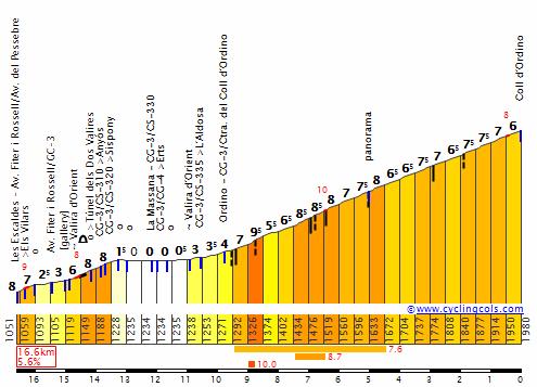
Thats why we get our asses back on the north, back into the Envalira, after a short but painful detour by Ordino, in order to start the race in a bang.
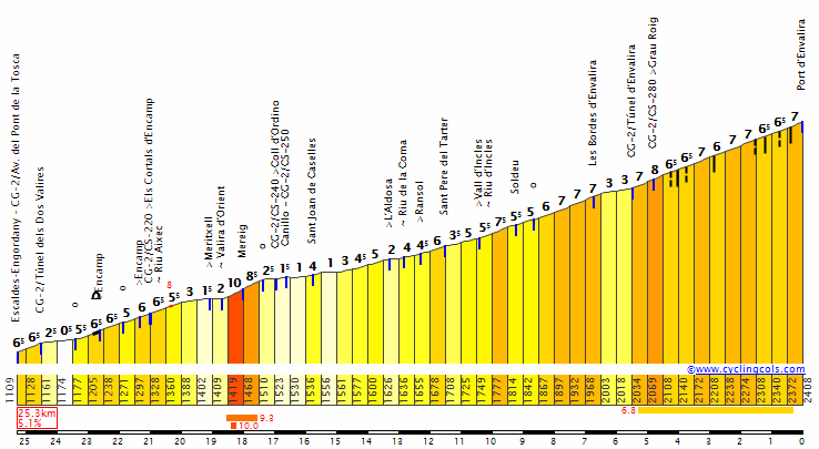
26km of climbing in the first 41, thats going to be rude for the riders, hopefully the long descent from Pas-de-la-Casa will be there to calm things down. But not too much.

OrdinoW.gif


EnvaliraW.gif


Then, we decide to go to an area rarely seen on the Tour : The Cerdagne.

Its just too far away from the main block of passes, like the Pays Basque. Worse, there is almost no pass and there isnt a true realistic stop there except for Font-Romeu, which is not in the best spot to do so cycling-wise.
For the basque region, its really a shame, for here, at least i can conceive that ASO wont move there too often...but come on, once in 40 years ?
In order to give a full explanation, i probably should tell you that this département is among the poorest of metropolitan France, with (by far) the worst unemployment-level (despite a lot of summer-jobs available, which should tell you how bad it really is) and other red flags in similar important areas.
For ASO, that wont be good. But as i seem to be a greater person than them, i dont care about the size of your bank account. Just of your breasts.

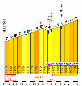
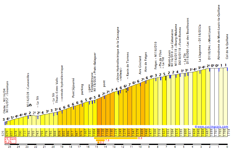
We'll start with the ascent to the ghost station of Err-Puigmal, as the snow went missing, the money disappeared as well, but we're going to stop at the midway point and go back in the plain.

ErrPuigmalW.gif


Rather than a plain, its more like a small poor man's altiplano, between two massifs and the Ebre valley.
No bowler hat and ponchos there, so we'll follow that pattern for a while, going up and down against the Puigmal and its neighbours on small roads, not very steep, but they just wont give an opportunity to rest.
Next, Mont-Louis, a beautiful fortress of Vauban.

ECH19970021_1.jpg


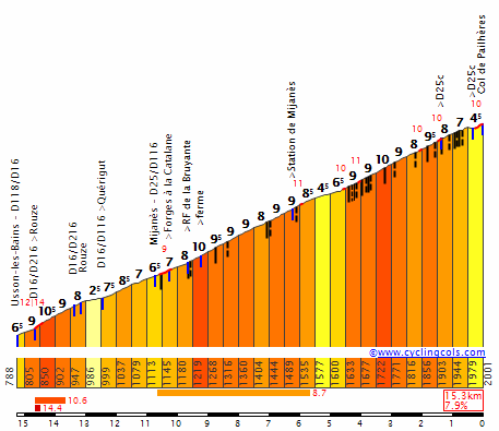
And then we'll move in the Aude valley after the Col de la Quillane.

QuillaneSE.gif


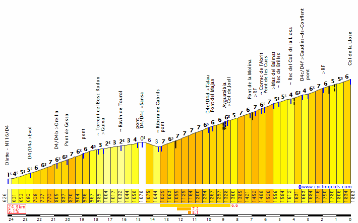
But instead of going down, lets take that road on the east with the short Col de Creu.

Again, not necessarily very tough, but there is no flat there.
In fact, this one is there in order to take the next one which follows smoothly : Le Col de la Llose.

LloseE.gif


13km long, thats a change from the previous ones. Other change with the road, which is very narrow at times, and of...inconsistent quality to say the least.
But bikes should not have any problem. The gradient is not horrible, and very consistent, actually.

Col%20de%20la%20Llose3.jpg

3480.jpg


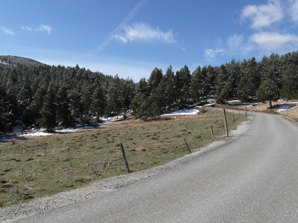
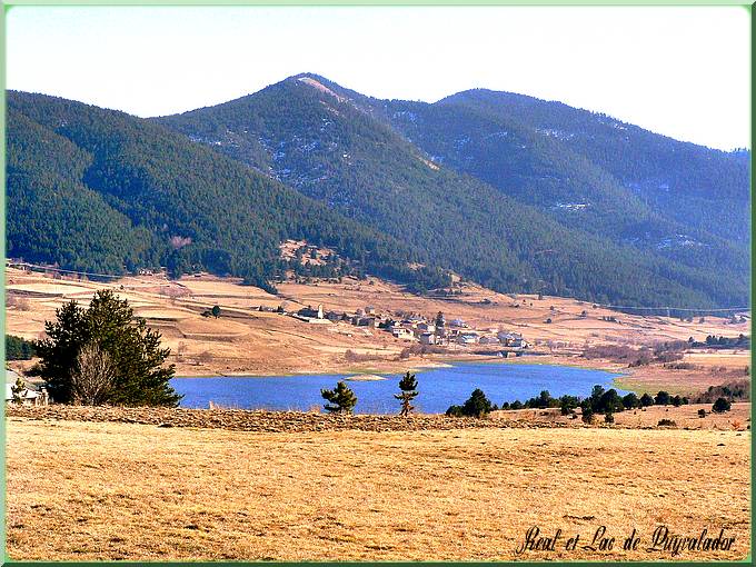
The small descent is done on the cleaner side, the road is perfectly fine there, and we get back next to the Aude valley, in the Capcir plateau, until the Lake of Puyvalador.

PuyvaladorLacReal680.jpg


The road was more of the false flat kind at this point, as the descent will really starts once we get in the forest. Watch out if you're not good at it.

Its very technical, the road is not in good shape, and there will be gaps created there.
Hopefully, no remake of the Bruyneel's antics of 1996 with the Madeleine, but the road, although good enough to be raced on, is going to be tricky.

mCIDQHM.jpg

1ItU7mo.jpg


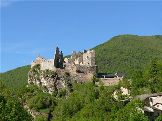
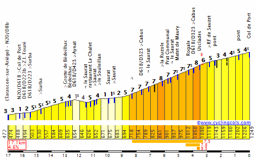
We'll finally reach the Usson Castle, with the Port de Pailhères waiting for us and separating us from the finish line, right at the bottom of the descent in Ax-les-Thermes.

ch%C3%A2teau%20d%20usson%20et%20maison%20du%20patrimoine%20021210.jpg


Its a popular climb, done 5 times in 10 years, and deservedly so. Its rough, and after racing for 195km with no flat whatsoever, thats rougher.

PailheresE.gif


Over 8% in average with several parts perfect to break the rythm of SRM-friendly riders.

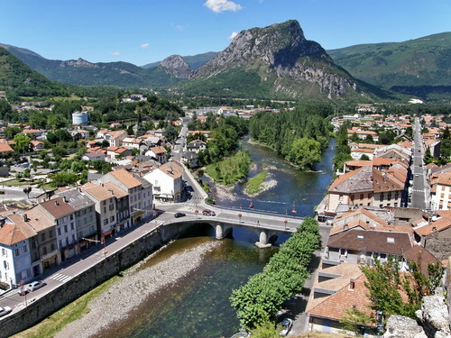
The descent is not easy as well and the finish is in Ax-les-Thermes, which is not common.
Indeed, we always have finished the stage in the region with a summit (Beille and Ax-3-Domaines are close) since 1965, over 11 stages.

I feel thats not necessary to have a finish in Ax-3 Domaines after a stage that should be difficult enough to see some sparkles.


QlIrPzW.png

RzwSbVk.png
 
Jul 26, 2015
145
0
0
Visit site
Stage 17 : Tarascon-sur-Ariège - Goulier-Neige, 131km

Tarascon already received the Tour, but its situation is not perfect.

tarascon.jpg


Its too far from the massive and prestigious climbs, and too close to other cities (Foix, Pamiers and Ax-les-Thermes) to be considered when the stage avoids those. So that city only received the tour once, in 1998.
Luckily enough, its perfect for us today.

For the last mountain stage of the race, we need to do the best we can with the area, and its more than enough to have a nice stage. And yes, that means no Tourmalet or no Aubisque.

As we cant start from Foix for reasons explained later, Pamiers is too far back in the valley, as is Ax-les-Thermes, which was already used anyway.
So we're left with only Tarascon, as we want to start right away with the climbing.
The Col de Port might not be the most difficult ascent of the Pyrénées, thats true, but at least, its not flat.

PortE.gif


It will allow us to reach the mighty Col de Péguère, with a shortcut.

3591.jpg


Which means that the only section (4km) left...is the one over 10%. With a brutal km with the gradient over 14%, there will be opportunities.

PeguereS.gif


As it is the last stage really likely to create big gaps, i want to encourage the riders to try something and move their asses. Not wait for the last moment.
That wall is perfect to throw dynamite in the wheels of several heavier riders.

Instead of going down to Foix (which is why we couldnt have started from there, as we would needed that road from the other side), we're going north through the Plantaurel, just to climb back from the other side.

5606131.jpg


To do that, we'll go through the Côte d'Esplas (3rd category) and use a forgotten climb on the Tour, the Col de la Crouzette. Unseen since 1976. Basically running a parallel way along Péguères, its easier, of course, but not that much.

CrouzetteN.gif


8km over 8% is no piece of cake, its not very long, but as we're going up and down all day, that one will hurts and is steep enough to offer some chances.
The Col de Saraillé is a big bump on the road to Ercé, and then we're heading south to Aulus-les-Bains.

SarailleN.gif


In this village starts the longest ascent of the day, the Col d'Agnès.

AgnesS.gif


Fantastic piece of pun material, french speaking guys there probably know what i mean, but also a difficult one.
Only seen 5 times on the Tour though.

Its not that long, actually, 10km, basically, but the incline at the bottom is real. 10.5% over 1Km, over 9% for the first half, it gets easier at the end, but at this stage, thats not an issue anymore as the biggest group of favourites should, hopefully, be less populated than the hamlets we're going through.

village1.jpg


The Port de Lers, in that direction, follows immediately, but its mainly there to just prevent any rest. Im sadistic.

LersW.gif


To be or not to be, that is the question, and it seems that i am.

The descent will be quickly done to reach Vicdessos, and then, the last major climb of the Tour awaits : Goulier-Neige.
Thats a new one, once again. Goulier-Neige is one of the smallest ski stations of the area.

s08032013513a0b6501fc3.jpg

Hopefully, we will have that kind of weather for the race.

The road is perfectly fine (until the last parking, filled with gravel), except for the punishing gradient we have there.

GoulierNeige.gif


Once again, as it is the case with most of the climbs of the vicinity, the length is not as impressive as the legends from the West, but the slope has nothing to be ashamed of.

The climb to the ski station is 9.4km long from Vicdessos, over 8% in average. There is a relapse in the village of Goulier, at the mid-way point, thats lowering that average, but otherwise, its more than enough to cause trouble.
Difficult enough to justify taking chances as controlling the race will be seriously challenging, but not difficult enough to justify the tragic waiting game we're too often used to see. Especially as the last big mountain stage.


7DSmYcx.png

JxsW9Xd.png
 
Tour of Japan: 'The Tour of the rising sun'

I decided to create a new stage race in a country I knew very little about in terms of route planning. Having spoke with a few posters it was decided that Japan would be my choice, So here it is, 9 stages with transfers kept down to as low as I could manage bar one long transfer. One thing is for sure, I cannot see many sprinters turning up! Hope you enjoy:

Stage 1: Aomori - Noshiro - 188km

6iazjql.png


ea68SWL.png


We start the Tour in the port of Aamori, the most Northern city of Japan. here we wind our way South-West to the town of Noshiro. There are 2 large hills to negotiate for the peloton at the halfway point of this stage, these climbs may be enough to put some riders into difficulty, However with almost 70km's of flat roads (bar one short hill) to the finish there should be a large group fighting it out for the first leaders jersey of the Tour.

bbrymQs.png


P9PQGaV.png
 
Stage 2: Akita - Mt Horaizan - 191km

Pgk8JIm.png


ivd8yh3.png


The 2nd stage of the Tour and things start to get serious already, the first of 3 mountain top finishes of the race. The peloton again start on the coast, this time in the city of Akita and begin making their way down South. The first half of the route is fairly hilly however there are no big tests. The three 3rd Cat climbs should all be swallowed up by the days break.
With just under 80km's to go the bunch hit the 1st Cat climb of Sensumori which should serve to soften the legs, A trip back down to the coast follows before they turn East towards the final mountain.
The climb actually follows the road up to Mount Chokai however there is no access up to the top unless you hike. The climb is 16.5k and averages just over 6%, it's fairly irregular with some false flat sections and some ramps of almost 10%. The winner here will surely believe he can go on and win this race, however there are some big tests still to go over the next 6 days.

743dwON.png


2bma2pg.png
 

TRENDING THREADS