• The Cycling News forum is looking to add some volunteer moderators with Red Rick's recent retirement. If you're interested in helping keep our discussions on track, send a direct message to @SHaines here on the forum, or use the Contact Us form to message the Community Team.

    In the meanwhile, please use the Report option if you see a post that doesn't fit within the forum rules.

    Thanks!

Race Design Thread

Page 172 - Get up to date with the latest news, scores & standings from the Cycling News Community.
Stage 3: Niigata iTT - 30.6km

Ku2AgVk.png


ponoRfz.png


The 3rd stage will see the riders tackle the clock for the only time of the Tour. The 30.6km route is mainly flat as we start and finish around Niigata, the busy port City on Japan's West coast and its suburbs.
There is one small test for the riders, after almost 8km they will head up the hill of Kukudayama which averages 8.5% for 2k's. Following the short descent there is 20km's of flat, open roads so the specialist's can really make some time back here.

wIyqUuV.png
 
Jul 26, 2015
145
0
0
Visit site
Gigs_98 said:
Today I also though about including this mtf in my next tdf, and as soon as I think about it someone uses it. :D

Well, you know your stuff, Sir.

Stage 18 : Pamiers-Montauban, 127km

pamiers_1.jpg


Pamiers is the largest town of the Ariège département, but received only once the Tour (2010).
As explained in the previous stage, its location is far from ideal, especially for ASO standards, the big mountains are just too far, and the Ariège is usually not used to the fullest.
So, we're leaving the area, and heading north. Montauban will be our stop, which is another city largely ignored, over 50K inhabitants and one only visit (1998).

montauban-268480.jpg


That one will be done quickly, as this stage is technically very uninspiring. We'll move around Toulouse, and basically stop as soon as possible to a decent-sized city.
Its short, its perfectly flat, and the outcome of the race at this point of the Tour will largely be decided by how the sprinters perform between themselves, if a sprinter is a step above the rest or if the wins are evenly distributed among the candidates, that kind of problem...


G3RZw16.png

6ZbnpsR.png
 
Jul 26, 2015
145
0
0
Visit site
Stage 19 : Cahors-Rocamadour, 60km, ITT.

Yes, the ITT is not on the stage 20, but the stage 19.
Thats a twist.

More seriously, the end of the Tour i draw follow a particular pattern i really want to see more often, you'll understand shortly enough.

Anyway, Cahors, is like Montauban, big enough to be an easy stop, but yet, almost never saw the Tour.

800px-Cahors_vue_pano.jpg


Same problem, Bordeaux is too close and often the first choice, and the Massif Central on the east is exactly at the wrong distance (too far to be a stage start, too close to make the jump for the next day, as that will wreck a day.)
Well, that assumes that ASO is actually using the Massif Central accordingly which is not the case (as the possible Limoges-SuperLioran stage is going to show us), so basically you're left with a position too far away from the usual suspects Pau and Bordeaux to be of any use.

Thats too bad, because the Quercy is a nice region (although not very populated, thats also a factor in the problem talked above), and we'll spend the second half of the day in the regional park of the Causses.

2076160-le-parc-naturel-regional-des-causses-du-quercy.jpg


Like around le Vigan, thats a seriously quiet place. Maybe because im absolutely not used to live in cities, but thats what i like.
The roads are not perfect, the route is not as favourable to the big engines as the first ITT, especially once we reach the park, roughly at halftime. You'll need to move your ass off the saddle quite often at the end of the stage.
The finish will be done in the only smurftown accepted on the route, Rocamadour.

rocamadour-1.jpg


pnr_causses_du_quercy_-_rocamadour.jpg


Yes, that rocks.
It is a smurftown (640 inhabitants), but with over 1 million of tourists per year, the Tour will merely be a statistical bump for the area.
Its actually a location known for a pilgrimage (with a black virgin), and there is a lot of churches up there.
Even though you're not of the religious kind, thats quite the place.

For the riders, the last 15km are going to be much more difficult, as explained earlier, you have bends, its twistier, but as you're coming closer to the finish, the road elevates itself.
Its not that difficult, we're talking about several short hills with a gradient around 5-6%, but its the third week.
The last hill being the one to move us in the back of the castle, right at the top, but its not that steep (4th cat. level at best).

Other thing to consider, the weather, as this area is often subject to severely hot temperatures in July, as illustrated in 2003, with the ITT of Gaillac (90km to the southeast).
With the pressure of the last ITT and the fatigue caused by the previous 18 stages, this is going to be a demanding day.

VCTEsof.png

HgWn5NG.png
 
Jun 30, 2014
7,060
2
0
Visit site
Vuelta a Venezuela stage 8: Barquisimeto - Puerto Cabello; 182km
6hpgopvhycxl.png

rs5fm1jntrh.png

After 2 hilly stages we have an easy stage for the sprinters before the final 2 mountain stages.
The stage won't feature any real climbs, just some rolling terrain.
It's a transitional stage and the last chance for the sprinters.
The stage starts in Barquisimeto, the the fourth-largest city in Venezuela, that is known to be the "Capital musical de Venezuela", the Musical capital of Venezuela and finishes in Puerto Cabello. Puerto Cabello has the biggest port in the country and is therefore very important for the oil industry.
Barquisimeto:
barquisimeto.jpg

barquisimeto-685x340.jpg

Puerto Cabello:
puerto%20cabello.JPG
 
Tour of Japan, Stage 4: Nagano - Azumino - 198km

RwrMW4a.png


D34MVZO.png


My 'Tour of the rising sun' returns with another stern test for the peloton. We start on day 4 in Nagano, where of course the 1998 winter Olympics were held. From Nagano we start climbing from the start with the 8% test of Santazan followed by a short descent straight into the hill of the Takaka shrine.
The riders will continue this up and down theme for most of the day with very little to flat to speak of. With just over 14km's to go the bunch (or whats left of it) will climb the final test of Hikakryoma. The hill is 4.3k long and averages out at 7.3%. With 10k to go at the top it could suit a late attacker who could get away on the descent. There are just 4km's of flat before the finish in Azumino. With over 6000m of climbing in the day the bunch will have earned their pay!

rKbdo0o.png

3uOhCYf.png

OOq2Up7.png
 
Stage 5: Toyama - Nanto -167km

RDvVV4Q.png


mAeuOyV.png


On stage 5 the riders start in the southern suberbs of Toyama, its another tough day for the bunch with 5 categorised climbs including 2 1st Cat mountains and some very steep ramps that are not classified. The riders start off with some gentle slopes in the opening 50k's however there it soon starts to turn cruel. Either side of the Togomura hill you can see 2 spikes, each of these is a short, sharp hill with both averaging around 25%.
On the descent from the 2nd sharp test the riders will head straight into the cat 1 mountain of Takashozu which should whittle down the peloton even further.
The route continues to meander up and down until we reach Mount Louzen. The 8.6km climb averages over 8% and should see some action amongst the GC men, perhaps even rider's who have lost time and been given the freedom to attack. Following the summit we have a fast descent into the town of Nanto, like yesterday a strong descender could attack here and put time into the other favourites.

Kt3Pc21.png

Y7Fenw5.png
 
Now that the Race Design Challenge is over, back to Germany.

The long pause means we may have lost the way of the route a bit, so here's a catch-up.

Stage 1: Schloß Pillnitz - Dresden (EZF)
Stage 2: Chemnitz - Halle (Saale)
Stage 3: Magdeburg - Buchholz in der Nordheide
Stage 4: Verden an der Aller - Clausthal-Zellerfeld
Stage 5: Göttingen - Winterberg
Stage 6: Frankenberg an der Eder - Königstein im Taunus
Stage 7: Hanau - Schlesingen
Stage 8: Bayreuth - Regensburg

Stage 9: Wasserburg am Inn - Berggasthof Obersalzberg, 182km

ip45d1.png


GPM:
Mooshäusl (cat.4) 1,6km @ 6,1%
Schwarzbachsattel (cat.2) 6,3km @ 6,2%
Hochschwarzeck (cat.2) 6,1km @ 6,5%
Hintenbrand (cat.1) 5,2km @ 11,3%
Ahornbüchsenkopf (cat.1) 7,0km @ 8,3%
Ahornbüchsenkopf (HC) 11,5km @ 8,7%
Berggasthof Obersalzberg (cat.2) 3,5km @ 11,8%

The first of our duelling queen stages in the Deutschlandtour sees us heading for the meanest mountains Germany has to offer, and that of course, just like everybody who ever tries to put together a Deutschlandtour, means heading for the Berchtesgadener Land, where the brutal ascents lie. Though it obviously is the most logical MTF host in the area, however, for historical reasons the Germans are reticent about celebrating the Kehlsteinhaus, the notorious Eagle's Nest, much as how no matter how many ideas for mountain stages in the Sierra de Madrid are talked about nobody expects the Vuelta to ever finish at Valle de los Caídos. As a result, therefore, we've gone for a smaller uphill finish, short but extremely steep, on the lower slopes. Which in itself will hopefully drag attacks earlier.

impressionen.jpg


We start in the scenic town of Wasserburg am Inn, which is a small city of 12 000 inhabitants which historically served as the port to Munich, but at present is perhaps best known as the hometown of biathlon star Franziska Preuß. The first half of the stage is little to write home about as we head inexorably towards the German Alps over rolling terrain, with only the small rise to Mooshäusl to break it up as we circle the Austro-Bavarian border before turning to enter the mountains themselves at Bad Reichenhall.

BGL11_01.jpg


The wick is slowly turned up in this stage, we don't head straight for the slaughter; there are a couple of warmup climbs before we get to the monsters. First up are the inconsistent ramps of Schwarzbachwachtsattel, then the less inconsistent but slightly steeper on average Hochschwarzeck, which leads to a well-known ski area.

im033a149aa713fb004.jpg


The descent from here takes us into, of course, Berchtesgaden itself, the town that the whole area is named for, and where the first intermediate sprint takes place. This is a symbolic intermediate which signifies the transition of the stage from tricky to MURDERKILLDEATH.

Straight from here we head into the ungodly steep Hintenbrand climb, which is a cat.1 climb despite being just 5km long, because, well, famous short steep cat.1 climbs like in the Vuelta - along the lines of Urkiola, Peña Cabarga or even Xorret del Catí - don't really compare. Urkiola is longer but 2% less steep; Peña Cabarga is just 300m longer and similar to Urkiola in gradient; it has the same maximum as Hintenbrand (18%) but it has a respite, which Hintenbrand does not; Xorret del Catí is the same steepness, but is over a kilometre shorter. This is horrible.

HinterbrandW.gif


The great thing about this as well is that the descent isn't really a respite, it is mostly downhill false flat, so riders aren't going to get the break they so desperately need after those slopes. And then, they enter a circuit. They actually enter just AFTER the finishing line (about 200m after it actually) so they do two laps including crossing the finishing line twice. This circuit includes the southern face of the brutal climb of the Roßfeld Panoramastraße (the summit chosen is called Ahornbüchsenkopf, after a spot near to it). This is a two-stepped climb; the first time we do just the second step, the second time we do the whole monstrous ascent, and then the final time we just do the first step, and finish at the Berggasthof Obersalzberg which you can see noted on the below profile:

RossfeldS.gif


The second half of the climb is a difficult enough beast, 7km at over 8% (I don't count the final kilometre of that profile on the basis that it's pure flat, from Ahornbüchsenkopf to the "true" summit of the Panoramastraße), and then there is a steep and very technical descent. The first crossing of the summit is at 46km from the finish, so only the truly adventurous will go for it from here, but the stacking together of this with Hintenbrand will surely lay waste to a lot of domestiques. The second time, when they climb that full profile, commences at 31km from the line and ends with just 19km remaining, so moves here are likely. The most brutal slopes being at the bottom will really harm the field and trim it down, so moves on the higher slopes and their dramatic backdrops will be vital - and with the rest day tomorrow, there's little excuse for not going for it.

15659933440_8638fafd59.jpg


49376577.jpg


I have also looked to incentivise the early move by placing the second intermediate sprint at the village of Untersalzberg at the end of the descent, just 5,3km from the line - however... the last 3,5km are the first 3,5km of the Roßfeld Panoramastraße, so they average over 11%. Even if people leave it until then there will be some time gaps to open up as surely the domestiques will come at a premium with Ahornbüchsenkopf just 19km from home.

There is happily plenty of parking space at the Berggasthof Obersalzberg, near the Dokumentationszentrum and serving as a link both to the salt mines and the Eagle's Nest, and this means that it can be a viable host for a finish. The climb is steep enough to scare, long enough at that gradient to ensure gaps are opened, yet short enough to tempt early moves with a rest day to come. And given many climbers could have lost a lot of time in the opening ITT and the cobbled monstrosity of a stage to Halle and the long cobbled stage to Buchholz, maybe they'll need to.
 
Into week 2 we go:

Stage 10: Ruhpolding (Chiemgau-Arena) - Mittenwald (Kalvarienberg), 161km

amxrgy.png


f3t3jr.png


Climbs:
Wallhöhe (cat.3) 4,0km @ 5,7%
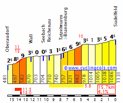
Südelfeldpass (cat.2) 8,0km @ 4,7%
Kesselberg (cat.3) 4,4km @ 5,2%
Kalvarienberg (cat.4) 0,9km @ 7,0%

I'm not sure if I've ever mentioned this, but I love wintersports, in particular Nordic skiing and biathlon.

</sarcasm>

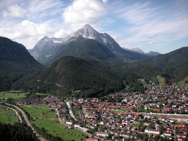
Right, given that I'm now transitioning across the south of Bavaria to link the Berchtesgadener Land high mountain stage with the climbing to come, the first stage after the rest day is a similarly transitional stage which hops along the Austrian border in the foothills of the Alps and isn't likely to be too much of a challenge but still offers a couple of questions for the top guns to answer. And speaking of guns and challenges in the Alps, what better to do than to traverse the well-known sites for my other favourite sports? And that's why we find ourselves starting in the glorious, recently rebuilt mecca of biathlon, the chocolate box town of Ruhpolding, or more accurately, the state of the art biathlon and cross-country skiing arena just outside it? The Germans love their biathlon, and annually in January they pack the stands to cheer on everybody in sight, especially their own and near-neighbours the Austrians.

preview_0.jpg


Rolling westwards from here, the first significant town we come across in the Alpine valleys is Reit im Winkl, which recently hosted a mountaintop finish on Winklmoosalm in the Bayern-Rundfahrt (one of the few stages in the recent history of that race to actually show some tiny modicum of understanding of the terrain available in Bavaria!) and serves as the hometown to XC skier (and late biathlon convert) Evi Sachenbacher-Stehle and biathlete Andi Birnbacher. After this there is a short period traversing Austrian territory to get across the Inn floodplain, before entering the mountains again with the two-stepped ascent (split into two climbs in the categorization) of Südelfeldpass.

SudelfeldE.gif


A tough descent into Bayrischzell follows, before a long flat period enjoying the scenery of the valley roads and foothills. The stage only really offers further challenge in the last 35km, at which point the riders take on the scenic and twisty 
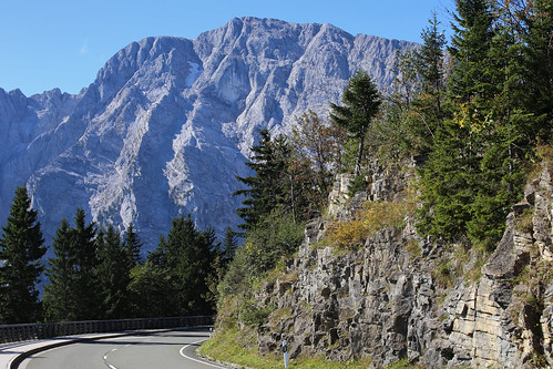
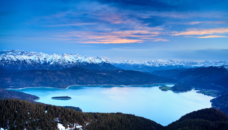
Kesselbergstraße which takes us to the shores of the scenic Walchensee, which we ride along the edge of for a few kilometres of amazing helicam footage.

MG_2022k.jpg


The next thing to come is the last intermediate sprint, in the small town of Wallgau, after some rolling terrain and uncategorized ramps. Wallgau is a piece of everything you expect from Upper Bavaria, with chocolate box scenery, men in Lederhosen, women in Dirndls, Alpine Gasthöfe, beer, wurst, and everything else you expect. It's also famous primarily nowadays for its most famous and beloved daughter (and walking Bavarian stereotype), Magdalena Neuner (now Holzer, but still universally known by her maiden name), an unreliable but at times unbeatable biathlon great who won multiple Olympic titles, ten world titles, multiple overall World Cup titles, and still retired aged 25. The rest of the stage is uphill false flat that takes us the remaining 13km into Mittenwald, which is where many of the training routes that the Garmisch-Kaltenbrunn-Mittenwald talent factory uses is located - a multitude of Germany's best biathlon stars have come out of this facility in recent years, although curiously as I've mentioned before, all of them female.

Mittenwald is yet another piece of ludicrously scenic Bavarian scenery, sitting in the shadow of the Karwendel mountain and serving as the border outpost, the last stop for Germans before crossing the threshold into Austria. Like every town round here it has its own wintersports icon, and here it is multiple Olympic medallist Martina Beck (née Glagow), who the town's park is named for. No matter where you go in Mittenwald, the mountains remind you of their imposing power even amidst the beauty.

gjaidsteig1-mittenwald-93.jpg


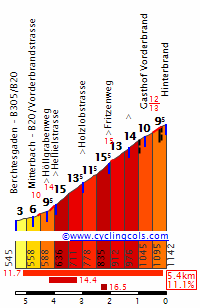
Here, however, there is a sting in the tail, because the closing kilometre is a tricky one. Perhaps giving it mountains points is a bit excessive, but it isn't quite the sprint. After all, the historic centre of Mittenwald needs to be traversed first, and it's better not to finish on a technical test in case crashes make a big mess of things. Riders will however need to place themselves well, because the final kilometre is uphill heading west from Mittenwald to the chapel at Kalvarienberg; there is a sharp left hander with 400m to go and the last kilometre being mostly uphill at 7% makes there the potential for a few seconds to be won or lost here. This would typically be a stage for the break, but with this finish then puncheurs or more adept hill sprinters in contention for the win and needing time, like Valverde or Rodríguez, might want to see if they can pick up bonus seconds on this finish from less punchy riders. After all, it's only 900m and this is nothing like Valdepeñas de Jaén - this shouldn't be outside the remit of the likes of Matthews or Lobato, and also, I'm afraid to say, our new World Champion, unfortunately.

It may go to the break anyway given the days coming up, though, in which case it might be interesting to see who has the legs on the last ramps.

012_Mittenwald_aerial.JPG
 
Great stuff once again, Libertine.

Giro d'Italia

(Wed) stage 4: Peschici - Vieste, 161 km

p9n7ur1lch19.png

cqgr7nc9xi8l.png


The stage takes place entirely on the Gargano Peninsula, the "spur" on the Italian "boot". The Giro had a brief love affair with Gargano in the noughties with three stages ending in Peschici. In 2000 they came from Matera, climbed Monte Sant'Angelo and rode up the coast road. Di Luca won. In 2006 they also climbed Monte Sant'Angelo, but then continued inland and descended into Peschici. Pellizotti won. In 2008 the skipped Monte Sant'Angelo and took the coast road. The planned Circuito del Gargano did not happen though, as the riders protested the planned length of the stage (265 km). The shortened stage (still 232 km) was won by Priamo. All three stage winners have been suspended since.

Peschici
foto_01.jpg


This time Peschici holds the start of the stage. Soon after the start the riders will climb the mountain massif in the center of the Gargano. This area is (quoting wikipedia here) partly covered by the remains of an ancient forest, Foresta Umbra, the only remaining part in Italy of the ancient oak and beech forest that once covered much of Central Europe.

We stay on this plateau for some good 40 km, then descend to sea level, just to start climbing again. Via tons of switchbacks we reach Monte Sant'Angelo, a town of 13.000 people and a popular destination for pilgrims. It is a very regular climb, 10,6 km at 6%. After the descent we spend the rest of the stage near the coast, which looks like this:

km 122
6q2povcquyk.png


km 146
3oetjz6le265.png


km 150
3ij3q82orzwb.png


km 156
8icgbi2dmouf.png


Here is a profile of the final 20 km:

n84r46dlcex2.png


This obviously is perfect terrain for attacking. Should be pretty exciting, up to the finish under palm trees in Vieste.

Vieste
fbkt5lxv2kp3.jpg
 
We all know that Libertine's stage is great but aren't you overacting a bit? A few months ago I made almost the same stage, only with a downhill finish in Berchtesgaden instead of the uphill finish, and it wasnt the event of the year too. (Although that doesnt mean that the stage isnt great, it just isnt much better than many other stages on this thread
 
Tour of Japan: Stage 6: Kyoto - Ako - 209km

BZIlTux.png


nKog5Js.png


Day 6 starts in the large city of Kyoto, which was once Japan's capital city. Opportunistic riders will have marked this one out from the start as it really should be a day for the breakaway. We have 4 main climbs in the opening half of the stage, almost straight away the peloton will climb up to the Konzo Ji Temple which has slopes approaching 10%. The main climb of Mount Rocco is passed with 75k's gone and by this point the few sprinters here will surely be put in to trouble.
If a good break works well together they should build a big enough gap over the bunch inside the last 100km's which are relatively flat. With just over 40km's to go the bunch climb the steep hill of Shiroyama, it averages 17% for 1k with a max slope of over 25%. With the coastal city of Ako in sight the riders hit an uncategorised ramp with 10k's to go which averages around 5%. The final 1.5km's are a slightly uphill drag of between 4-5% so we could see a few splits from the GC group if riders are not careful.

ROivihA.png

nHR2Kxm.png

Ij1bE8C.png
 
Re:

PremierAndrew said:
LS, how long does it take you to 'make' and write up one of these stages on average
Designing varies, usually I have an idea of what the race route will be in stage races based on key locations and stages I want to include, and work out how to link them (and then modify the original ideas based on the results of that). Interesting flat stages and cobbled ones take longer than the hilly and mountainous stages as more local knowledge is needed and I know how to link most of the main climbs in the major ranges.

I tend to either abandon a race before all stages are completed or I will get everything completed before I start posting them; as a result time constraints, distraction, motivation and laziness are usually the reasons for long gaps in posting races (e.g. the Deutschlandtour has been rather abandoned of late because of the Race Design Challenge and the Vuelta taking up much of the time I spend on such things). The posts tend to vary in how long they take, but really, I dread to think how much time I've spent putting them together.
 

TRENDING THREADS