• The Cycling News forum is looking to add some volunteer moderators with Red Rick's recent retirement. If you're interested in helping keep our discussions on track, send a direct message to @SHaines here on the forum, or use the Contact Us form to message the Community Team.

    In the meanwhile, please use the Report option if you see a post that doesn't fit within the forum rules.

    Thanks!

Race Design Thread

Page 180 - Get up to date with the latest news, scores & standings from the Cycling News Community.
Lusette-Aigoual, since Puy de Dôme is inaccessible it's arguably the only HC in the Massif Central, depending on your geographical limits re Ventoux.

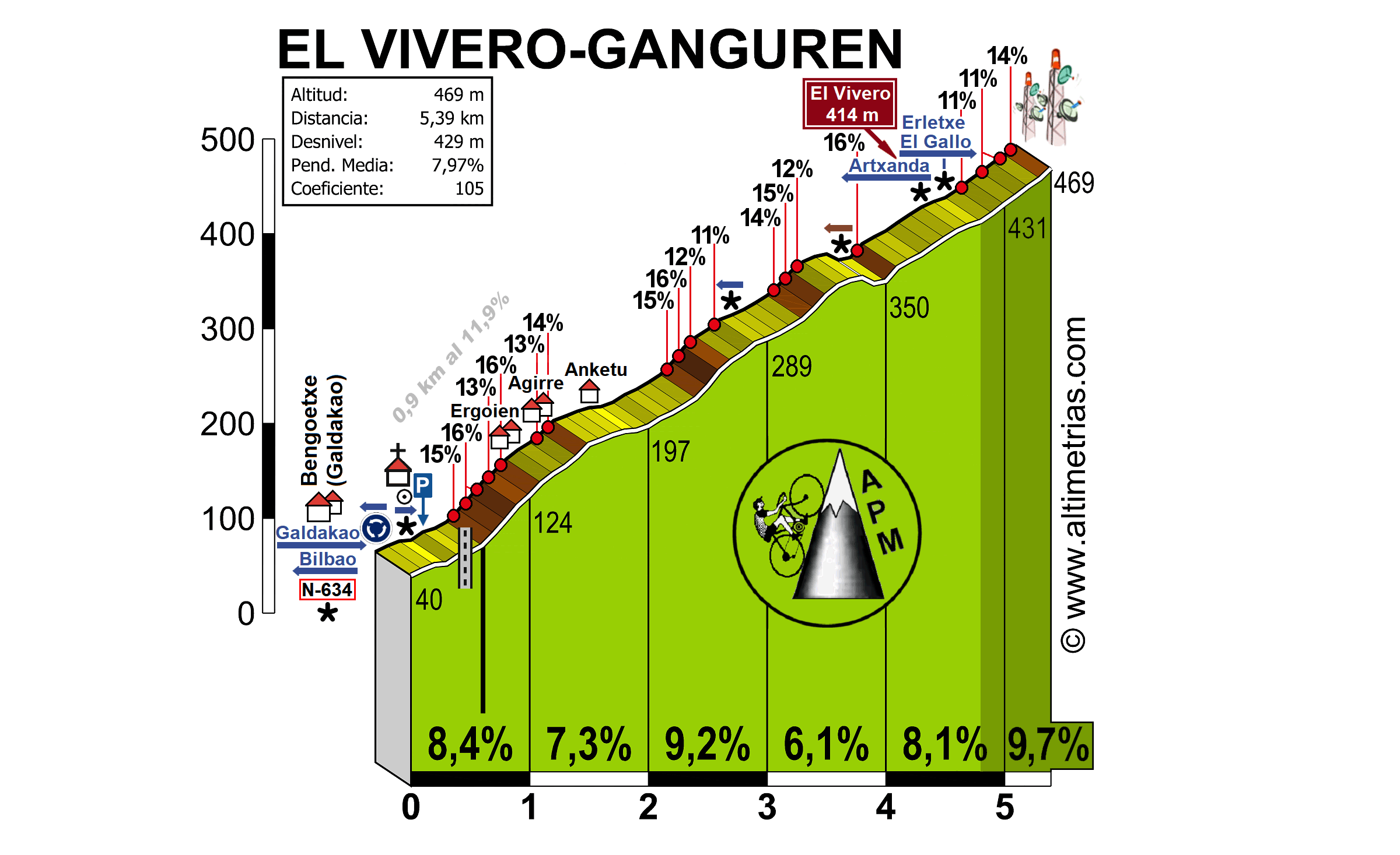
Stage 9: Solsona - Monestir de les Avellanes, 189km

2ikqzjd.png


359jzb9.png


GPM:
Alt de Serra-Seca (cat.2) 10,6km @ 5,8%
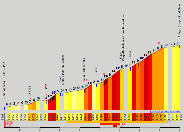
Coll de Boixóls (cat.1) 14,4km @ 5,1%
Alt de Montllobar (cat.2) 15,0km @ 4,0%
Coll d'Ares (cat.ESP) 16,9km @ 6,4%
Port d'Áger (cat.3) 4,1km @ 6,6%

Following on directly from yesterday's brutal stage it's another of that type of stage the Vuelta never seems to do - and when it does, it gets great racing like stage 20 this year - where the stage doesn't finish in a climb and the key climb isn't the last one. After yesterday however, today is all about a different type of climbing. Whereas yesterday was all brutal hell-slopes, this is a more sedate, rhythmical climbing that will hopefully suit an entirely different type of climber.

576_1351061971faana_ciutat_nvol_pt_modified.jpg


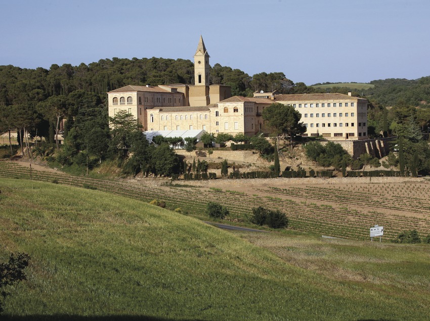
Today's stage is effectively the race of Monasteries; we start in the medieval centre of Solsona with its impressive cathedral and monastery complex, and end at a somewhat more isolated Monastery, the Monestir de les Avellanes. The transfer from yesterday's finish, for once, is short, so the riders should be well rested, which is good as there's once more quite a lot of climbing to do today.

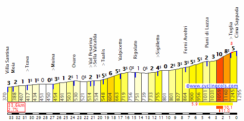
Unlike yesterday, when the riders were eased into the stage before all hell broke loose in the second half, today there should be battles right from the gun, because there's an early ramp and then we're straight into the Alt de Serra-Seca, a cat.2 climb which might have been cat.1 if placed in a more integral point. It was a cat.1 when it was used in the 2009 Tour de France in the otherwise anæmic Arcalis stage. It's realistically a bit shorter and steeper than its stats show owing to its last couple of kilometres being essentially flat passing the Mirador de Serra-Seca which offers some stunning views. We then have the Coll de Boix, which was named Port del Compte after the nearby ski station (and shouldn't have been, Port del Compte is an entirely different summit) in the 2009 Tour (one of the smaller things it got wrong, admittedly, since that shingle-inducing Tour is one of the worst-designed races in history). It's about 3km at between 5 and 6%, I elected to go the "no puntable" route; there are more than enough points-paying climbs in this Vuelta.

82252577.jpg


The wide and sedate descent takes us into the scenic river crossing town of Coll de Nargó, before the road turns uphill again, this time for a longer but more gradual climb, to another classic of the Catalan Pyrenean foothills, the Coll de Boixóls. Given that the Volta a Catalunya now takes place in March, sometimes some of the highest passes can be an issue so we are more frequently seeing the stages through the foothills, which means more attention on climbs like this one. Like a lot of Catalan climbs it is long rather than complex, with mostly consistent gradients broken up by a brief plateau. This often means cumulative climbing is the way to enforce selectivity as steep ramps on connecting climbs aren't always available, which is the approach I've gone for here given that until the business end of the stage the hardest ramps are on Serra-Seca.

99dd8af1a6b4d47037476c7203ac3436o.jpg


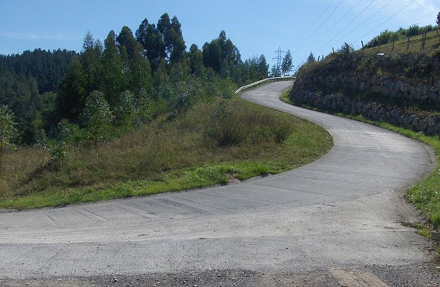
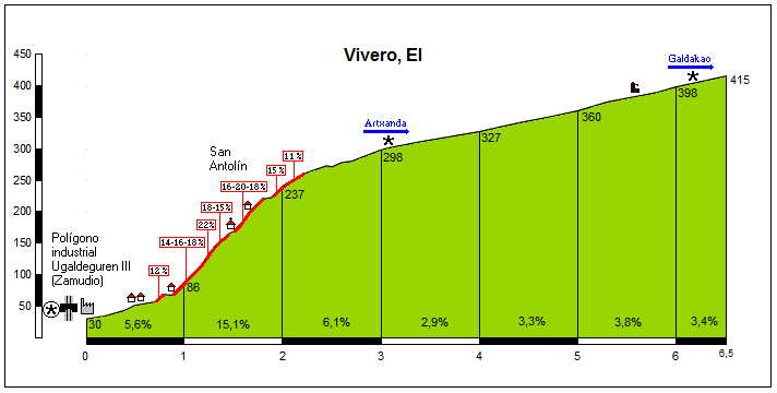
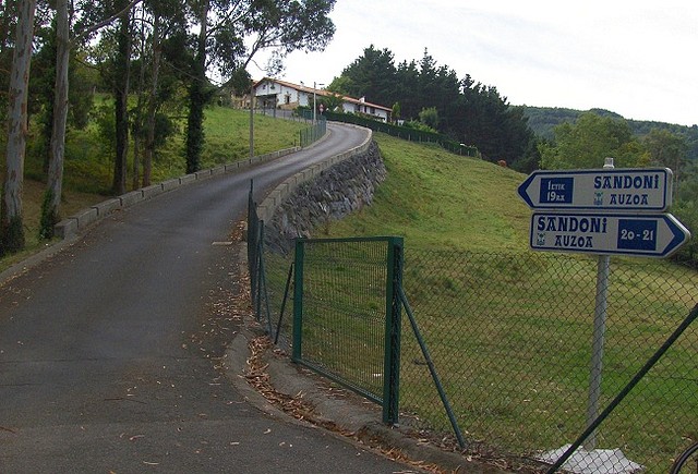
The little descent off of the Coll de Boixóls is pretty stunning as seen above, but like Serra-Seca there is a post-summit sting in the tail as well, as much as Boix and Serra-Seca are a double summit on the same road (as opposed to, say, Fumanyà-Pradell, which is a double-summit deliberately sought), Boixóls has a twin in the form of the Coll de Faidella, which from this side is a no puntable 2km at 5,4%, before a long descent which is very technical for the first 2/3 distance, the profile of which is here. This leads quite satisfyingly for the riders into a period of respite where the break can consolidate - I would anticipate at least 15 riders up the road, possibly more than 20-25 - and the Jersey rojo team can race manage. After passing through Tremp, the road goes uphill again, but once more the climbing is pretty gradual, being the two-stepped Alt de Montllobar which despite its length is only awarded second category status owing to the low average gradient; the first part is little more than false flat, while the final stretch is 8,5km at around 5,5% so not really cat.1-worthy (especially if Serra-Seca isn't!!!). The descent from this takes us down to Puente de Montañana, after which all hell is prepared to break loose as we take on the toughest climb of the day.

ares-por-alsamora.jpg


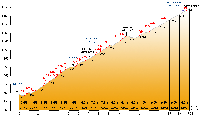
A thundering climb in western Catalunya, this Coll d'Ares is not to be confused with the more gradual and famous namesake on the French border in Pyrenees-Orientales. This Coll d'Ares has an average of 6,4% over 16 kilometres, so not perhaps the most dramatic ESP category you will ever find, but it does feature more than 20 ramps of over 10%, so consistency is an issue considering the way the rest of the climbing has been today. There are some spectacular hairpins and that for the most part the steepest parts are at the bottom should ensure this one creates some interesting scenarios in the race after yesterday's hell-slopes.

AgerLaunch.jpg


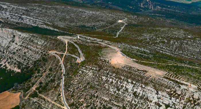
A similarly tricky descent into Áger follows, after the crest of the Coll d'Ares 33km from the line. The rest day is not tomorrow, although tomorrow's stage (the last before the rest day) is significantly easier in order to incentivize attacks today. For that reason as well, the intermediate sprint in Áger includes bonus seconds of course, 19km from the line, before throwing us into the final slopes of the day, a short sharp cat.3 burst up to the Port d'Áger. The full climb featured mid-stage in a 2013 Volta a Catalunya stage however we are only doing the last few kilometres having joined after the Coll d'Ares descent, giving us this final profile. As you can see it's pretty consistent climbing at mid 6s in the gradient, but cresting at 14km to go with only a short descent and false downhill flat to come should tempt some movers - again, there are very few mountaintop finishes in this race and none of cat.1 or ESP left for riders to save themselves for. The riders then leave the main road after the village of Les Avellanes to take a trunk road that leads to the Monastery, mainly for safety purposes as I didn't want to put the finish on the main road nor put a sharp left hander with only 100m to go. It only extends the run-in by about a kilometre, though, so I don't think it will too negatively affect the racing on Ares or Port d'Áger.
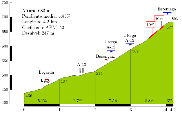
Monestir-les-Avellanes.jpg
 
DACH Rundfahrt stage 9: Passau - Kehlsteinhaus (197 km)

difficulty: ****
VnMPJcI.png

3YTfj9o.png


So we reached the last stage of the first week which also is the last stage of this tour, in Germany. However the riders are only a few kilometers away from the Austrian border through the whole stage. The start is in Passau. Although I basically write every time how beautiful the city is, and the sentence "the city is beautiful" probably doesnt mean that much anymore (although most of these cities are actually really nice). However in this case I have already visited the town and believe me, I haven't seen many more beautiful places than Passau. Just as an explanation, Passau is the place where the Danube and the Inn become one river. That doesnt only cause a natural spectacle, it also was a reason for old tribes to build a village, which later became Passau. Besides the two rivers the centre of Passau is also beautiful because of its narrow streets and old houses.
VtO34Ov.jpg


Although this is the first high mountain stage, the first 150 km's are almost panflat. That's because this whole part of the stage isnt in the Alps yet. As soon as the riders arrive in the mountains they start to climb with the first, easy pass of the stage, the ascent up to Hallturm. Although the climb is over 6 kilometers long its only slightly over 3% steep so its more a warmup than a real test for the gc contenders. However Shortly after the descent the real racing starts with the first HC climb of the stage, and probably the most famous climb of germany, the Roßfeld Höhenringstraße. There are basically 4 ways to go up this street: The probably hardest one starts in Berchtesgaden, one in Austria and two of which I use one start in Unterau. The ascent in this tour isnt as long as many other climbs I will use, but its very steep which makes it the first HC climb of the race. The descent isnt that difficult because although there are some switchbacks the street is very wide and in good condition. Moreover it isnt long because the descent, which normally goes down to Berchtesgaden gets interrupted by the start of the last climb of the stage.
2jFiQas.jpg


This last climb is another monster and the fact that its actually only 6.5 kilometers long only makes it seem to be easy until you hear that on this distance the riders go up an altitude difference of 750 meters which means that the average elevation gain of this climb is !!! 11.6% !!!. Thats very steep, Zoncolan steep, Angliru steep, or as the cycling fans would say after this stage "Kehlsteinhaus steep" ;) . Oh and because that alone is obviously not hard enough some parts of the climb are cobbled...have fun. Maybe some of you say that there is maybe not enough space up there, but there is a parking place and considering that the Vuelta can also finish everywhere they want, I hope it isnt such a big problem.
M89sMt5.gif

AsEz9Mf.jpg


This stage should cause the first really big gc shakeup. Cobbles, hills and the ITT might already have caused some time gaps but all in all many the time gaps between most riders will still be rather small. I know, the first mountain stage doesnt always have to cause time gaps, as we have seen in the tdf 2011 and steepness doesnt always mean action too as we have seen on the Zoncolan 2014, but some riders may already have a disadvantage, its almost impossible to control the peloton on such steep gradients and Tomorrow will be a rest day, so the riders shouldnt have anything to hold back. And don't be worried, after stage 10 there will be time gaps even if nobody has attacked so far
 
Oct 4, 2015
417
1
3,030
Visit site
Giro d'Italia Stage 3: Civitavecchia - Siena, 219km (**)
qs5h20.png

13z5n4m.png


Climbs: Radicofani (6,8km @ 5%)
Sterrato sectors: Murlo (5,5km, **), Radi (13,5km, ***), Colle Pinzuto (2,4km, ****), Le Tolfe (1,1km, ***)

Stage 3 takes us from Civitavecchia, a sea port located west-northwest of Roma, to Siena, known in the cycling world for being the finishing point of the Strade Bianche race - and sure enough, this stage features some of the race's signature sterrato roads. There are four sections in total (one of them, Radi, is broken up briefly by an asphalted section), which should be enough to cause some serious damage in the peloton. Particularly if it rains...
Other than that, it's a hilly stage, with only one categorized climb halfway through the stage, and very irregular terrain towards the end, where the sterrato sections are located.
 
Re:

52520Andrew said:
Stage 6, Clermont - Ferrand - Station du Lioran 207.8 km

I attack the Pas de Peyrol from the West as well but I follow the D 12 to the foot of the climb and bypass the Col de Nerrone. What I do by doing this is making the climb up the Pas de Peyrol harder in theory and it could give riders an opportunity to drop more by the time we reach the steep bit. What do I mean by the steep bit? The last 3 kilometers of this climb average around 11% and could make an excellent springboard for an attack. I doubt we see any GC men give it a serious go as it is too early in the race but it gets hilly the rest of the way after this with the descent, the climb up Perthus via the harder side, and then up to Lioran. This type of combo on stage 20 of a close race could be a lot more interesting. I have other plans for my stage 20 however so here it must go. It could however be a nice point for a dark horse to make a go for some time and a stage win however.

Just wanted to remark that Neronne from Le Falgoux is a pretty tough climb by itself, however there are 6 km from there to the start of Pas de Peyrol.

With Neronne

http://lescolsducantal.free.fr/images/Profil%20Falgoux%202.gif

Bypassing Neronne

http://lescolsducantal.free.fr/images/Profil%20Falgoux.gif
 
DACH Rundfahrt stage 10: Wien - Wien (46 km ITT)

difficulty: *****
vdFrHac.png

eyFFYDt.png


As some have you might have guessed, after I already talked about big time gaps on stage 10 in my last post, stage 10 is an ITT. It's the second one of the race but by far more difficult than the short opening circuit around Hamburg on stage 1. We are also in Austria for the first time of this tour and I think there is no better place for the first stage in Austria than Vienna. Vienna is clearly one of the most beautiful capitals of Europe, because of its important role in the history of the continent, which means that the city is full of old, historical buildings. The start of the stage is in front of one of those, the Wiener Riesenrad, one of the town's landmarks. Unfortunately parts of this Ferris wheel were destroyed in the 2nd world war, so it lost half of its capacity.
spEdHhU.jpg

The riders drive out of the Würstelprater, Viennas most famous theme park, and head south. After they arrive at the Danube (actually its only a sewer of the Danube, but in Vienna people simply called it the Donau, which means Danube, too. However the route quickly crosses the river and continues on the Gürtel, one of Vienna's most famous streets.
6TTQElF.jpg

A little bit later the riders leave the Gürtel and continue on the Heiligenstädter Straße. When talking about the most beautiful places of the city I'm sure absolutely nobody will mention this street in the middle of the industrial centre of the town, but its the best way to come into the north western part of the city. Moreover this section is once again short and the next section goes along the Danube again (this time the real Danube) and the riders wont leave the this road before they arrive in the next city, Klosterneuburg.
WRSVNAA.jpg

Klosterneuburg is also the point where the TT suddenly gets absolutely brutal. Thats because the first and only categorized climb, the Kahlenberg, starts here. Tbh, the simple data of the ascent isnt that impressive but the climb is cobbled. And not only this climb, the majority of the next 15 kilometers is on cobbled roads. These 15 k's are the Wiener Höhenstraße, a historical road which goes along the western border of Vienna and as you can see it on the profile, the western border is very hilly. Yeah, some of you might say that cobbles in a TT is a bit overkill, but a) the cobbles are in very good condition b) luckily the biggest part of the descents isnt cobbled c) I just love the Höhenstraße and really wanted to include it in this race. Originally I wanted to use it in a road stage, but I decided that an ITT on stage 10 is a good idea so I simply included it in this TT route.
lfCy91U.jpg

After the descent the route goes straight into the center of Vienna again. Here the riders ride over the whole Ringstraße, the definitely most famous street in Vienna, simply because every 2nd sight of the city is located here. The street was built during the regime of Franz Joseph (the guy who is jointly responsible for the 1st World War) who decided that Vienna doesnt need a city wall anymore and built this street where the wall stood before. The riders first pass the Museumsquartier, where the last split time will be taken, followed by the Heldenplatz, Volksgarten, the Parlament, the Rathaus, the Burgtheater, the Schottentor, the Schwedenplatz,....and the Staatsoper where the riders will detour into the finish line, the Kärntner Straße

Rathaus:
jFyCeXr.jpg

The Kärntner Straße is mainly famous for shopping, so its normally not allowed for cars to drive on it, but the street is very wide, so it shouldnt be a problem. The finish line is on the Stephansplatz, directly besides the Stephansdom, a famous cathedral in Vienna and known as the center of the city
vdG2KFS.jpg

Although there is a climb in the middle this stage should be for the TT specialists. However the time gaps between the gc contenders should be big and we would already have an idea how the final gc could look like.
 
Oct 4, 2015
417
1
3,030
Visit site
Giro d'Italia Stage 4: Siena - Pisa, 150km (*)
23wm9uo.png

28w2t7p.png

Climbs: San Gimignano (2,8km @ 6%), Compignano (3,7km @ 4%)

This stage is a pretty straightforward one; only 150km, with some hills early on but mostly flat towards the end. Sprinters should take this stage without too much trouble. GC riders will be recovering from the potentially-chaotic stage 3... and preparing for the very first summit finish of the race the next day.
 
Epic TT! Presumably after the rest day (9 & 15 is standard, I know we vary it a bit from time to time but given the format of your race it would seem sensible).

I am doing 10 + 6 + 5 in my Vuelta, so after the mountain heavy weekend, there's one stage left before the rest.

Stage 10: Huesca - Pamplona, 194km

332xeaa.png


30toswn.png


GPM:
Puerto del Perdón (cat.3) 4,2km @ 5,9%

After two days of heavy climbing duty, both inconsistent and steep (stage 8) and gradual and grinding (stage 9), the riders have just one more day to endure before earning a well-deserved rest day. And I've gone fairly easy on them as well; this is a nice little Worlds tune-up for the sprinters or the attackers, depending on position; I know many will leave the race after the rest day so may as well put it back a bit. Of course, there are further stages they may consider as tune-up stages, but it all depends on the year's routes really.

726477_1.jpg


The city of Huesca, with its iconic cathedral and double-lining of city walls, is one of the more famous towns in the north eastern corner of Spain outside of Catalunya. Its convenient location at the foot of the Pyrenées has led it to be a popular starting point for mountain stages in the Vuelta, with three of its last four appearances on the Vuelta route (in the real world) being at the beginning of a stage finishing with a summit finish. In 1999, we went to Pla de Beret; in 2004, the stage took us across the border to Cauterets for a finish at Cam Basque. In 2007 we went to that iconic 90s-early 00s Vuelta summit, Cerler. However, the last time the Vuelta set off from Huesca it was in 2012, going in the other direction, in the flat stage to Motorland Aragón referenced earlier.

After the riders start the day with a cup of coffee (Spanish Civil War/George Orwell reference) today, however, no mountains. We're going in the opposite direction to when Huesca has been approached in those previous stages, so instead of heading for the Catalan or Aragonese mountains, we will be leaving Aragón (our trip there was fleeting) and heading westwards into Navarre across a mostly rather flat and straightforward stage. While the scenery might be a little greener than that earlier in the race on the flat stages, owing to the more northerly location, this will still be one for wide open highways and distance, with the biggest town passed through being Ejea de los Caballeros.

Fotografia-aerea-ejea.jpg


It's not all flat though, as most visitors to this corner of the world will confirm for you. The Pamplona basin is more or less where the mountainous terrain of the Basque country meets the vast expanses of the plateau, but this could similarly be said of the area around Vitoria-Gasteiz, and the Sierra Alavesa is south of that. Even so, it is self-evident that the southern and eastern parts of Navarra are significantly less mountainous than the northern and western parts, which bear more resemblance geographically and culturally to the neighbouring Basque Country. And indeed, finishing in Pamplona will bring out many ikurriñak and lauburuak from those locals that identify as Basque, as seen at the 2012 Grand Depart when the race set off with a dramatic time trial. With Euskaltel being Basque and both Movistar and Caja Rural being based out of Navarre there was a real sense of home occasion (Caja Rural even wore a one-off San Fermín-themed TTT skinsuit for the first stage, tying in with Pamplona's most famous - and most controversial - tradition); though Euskaltel have disappeared, that the only teams flying the Spanish flag at the top level are both Navarrese will count for something here.

Of course, from the late 70s until 2011 País Vasco was kept off the Vuelta route; the part-Basque, part-Spanish nature of Navarra made it a difficult area to include as well even as the region produced the country's biggest star in cycling history, the great Miguel Indurain. Miguelón was guest of honour at the 2012 Depart, but the city duplicated its role as a stage host in 2014, hosting the start of the stage to nearby San Miguel de Áralar, arguably the toughest Basque mountain (again, depending on your definition, however it is in a comparatively nationalistic Basque part of the province). While the Basque separatists may have been a worry for the Vuelta, not so for the Tour, however, which attempted to honour Indurain with an epic stage finishing in his hometown, only for his dreams to have been quashed by then anyway, and the multiple major climbs before the long run-in only exacerbated this as he lost time. Nothing so complex as that today, however - just a single cat.3 climb, the short climb of the Puerto del Perdón 14km from the line.

Elperdon14.gif


16632134.jpg


Now, the road here only passes over the ridge that is the so-called Monte Perdón summit at a fairly low point, if we wanted an MTF we could ascend some way from this. But no summit finish is necessary here. For the most part the road is wide and easy-going, however the final kilometre being at 8,8% may put an attack to the front of the minds of some of the Classics men and those thinking about the Worlds, as an exploration of their form perhaps. I don't expect any GC men to really be tempted, even with the rest day tomorrow; it is still pretty close to the line though, so the temptation may be there... after this however it is just a rolling route in to Pamplona which will suit the bunch. Probably one for the durable sprinters - there is a lot of rolling terrain here and with Perdón so close to the finish the likes of Kittel may struggle to get back on in time if there's any action up front, but the Degenkolbs, Bouhannis and Lobatos of this world should have little trouble making it. I have resisted the temptation to extend the distance from the finish by doing a lap around the city as I love Pamplona and have been there several times; however given that I haven't really shredded the péloton down, making them take on some of those cobbled streets with a full péloton and putting those corners close to the line is spectacularly ill-advised, so instead they will race through town before turning right and finishing in front of the citadel. Rest day tomorrow...

pamplona1.jpg
 
Oct 4, 2015
417
1
3,030
Visit site
Giro d'Italia Stage 5: Massa - Zum Zeri (Passo dei Due Santi), 161km (****)
2h4cd8p.png

14ukqqv.png


Climbs: Passo Cento Croci (12,3km @ 5,7%), Passo del Brattello (11.8km @ 4,7%), Passo dei Due Santi (9.2km @ 8,2%)

Now we have our very first mountain stage of the race. Starting in Massa, the first half of the stage is flat, until riders reach the foot of the first climb of the stage, the cat.2 Passo Cento Croci.
CentoCrociS.gif

After Cento Croci there's little rest, as the riders will quickly take on Passo del Brattello, of similar length than Cento Croci but less steep.
BrattelloW.gif

Then comes a very irregular descent, followed by the climb to the summit finish in the small ski station of Zum Zeri. Starting with a 4km ascent averaging roughly 5%, followed by roughly 10km of false flat, and finishing with a steep final 10km section averaging 8,4%, with a full km at 12,5% towards the end.
DueSanti.gif

Any important gaps for the riders will likely be made in those final 3kms, with Cento Croci and Brattello selecting the riders that will fight for the stage. It's still early on the race, however, and a good performance here will likely lead to a run with the maglia rosa, so there should be some battle during the climb.
 
DACH Rundfahrt stage 11: Klosterneuburg - Mariazell (215 km)

difficulty: ***
1ruInqA.png

i52NL9k.png


After the ITT in Vienna we go into Alps, although not the high, western Austrian alps yet. We start in Klosterneuburg, the town which was already passed yesterday, before the Kahlenberg. I also forgot to mention that the Kahlenberg is known as the north western end of the whole Alps. That means that the start of this stage is already kind of in the Alps. However that will change quickly because the riders go through the Tullnerfeld, a completely flat area around the city Tulln, where the first intermediate sprint will take place. However after about 50 kilometers the riders enter the Wienerwald again, and have to face the first climb of the day, which will be the Klammhöhe, a flat little warm up climb. While the rider go on the mountains become a bit higher and the Wienerwald becomes the Gutensteiner Alpen. Here the riders have to up the Annental, an uncategorized, very flat climb. From here on the stage goes more or less always up and down. Next up comes the Ochsattel (3rd category), followed by the Kernhofer Gscheid (also 3rd cat.). Then there is no categorized climb one the next 35 km's, but an intermediate sprint after a little bump in Annaberg. The next climb is the steepest one of the stage, the Türnitzer Gscheid (3rd cat.) followed by the hardest climb of the stage, Wastl am Wald, the only 2nd category climb of the day.
olKYixP.gif


You might already see that there isnt that much to say about this route besides listing the climbs and intermediate sprints of the stage. The mountains around there aren't very high, no pass is so hard that it completely stands out and no big cities around here. There are only a few small skiing areas around here, but this part of Austria is just a low mountain range and there are no mountains higher than 2000m. I could have made this a real mountain stage by going more southwards, into an area called "Bucklige Welt" with some 1st category climbs, but there are enough mountain stages still to come, so I wanted to make this a medium mountain stage.

But lets come back to the stage. After the descent from Wastl am Wald, the riders go up the last climb of the stage, the Josefsberg. This little climb will probably be the decisive one for the stage, because there are only about 10 k's left after the top of the climb. However there is a short uphill section after the descent so its still possible to attack if a few riders are still together.

The finish is in Mariazell a beautiful place of pilgrimage, famous for its cathedral.
79gvwbv.jpg


This stage will probably go to the break, because I doubt that any team thinks its very likely they can control the race on such a hilly route and then win the stage. However its at least possible that a gc contender tries an attack on the last (and maybe although very very unlikely, also on the penultimate) climb because stage 12 will be the easiest one of the week, so the riders can rest a bit. The fight for the stage should be pretty interesting because I'd expect attacks from the beginning of the penultimate climb on, so this stage should be worth watching.

ps: I decided to cancel the Goldener Kilometer for the 2nd and 3rd week because something like that doesnt really make sense when the stages are way too hard for the sprinters to get points (and at the end it would probably make the competition less interesting because a rider like Sagan would take it easily)
 
Oct 4, 2015
417
1
3,030
Visit site
Giro d'Italia Stage 6: Borgo Val di Taro - Vicenza, 252km (**)
2rz8b5g.png

o58cyb.png


Climbs: Crosara (5,3km @ 6,8%), Perarolo (2,5km @ 7,6%)

Stage 6 is the longest stage of the race, clocking at a whopping 252km. It's a transition stage, as we head into the Alps. There are two climbs towards the end, the first being the climb to Crosara, used in 2013 and 2015, both in Giro stages finishing at or near Vicenza.
tappa_17_s_1.jpg

After Crosara there's the short climb to Perarolo, followed by its descent and 15 flat kms before the end of the stage.
The race's difficulty will start picking up after this stage as we head into the first weekend, starting with the first time trial of the race.
 
Oct 4, 2015
417
1
3,030
Visit site
Giro d'Italia Stage 7: Castelfranco Veneto - Montebelluna, 56km (ITT)
2q36tg9.png

iqifdd.png

Climbs: None

Next comes the first long individual time trial of the race, a 56km flat stage between Castelfranco Veneto and Montebelluna.
With lots of long straights and almost perfectly flat terrain, time trial specialists should be able to get sizable gaps on the weaker TT riders, and start clearing up the GC scene for the rest of the race. Climbers will have to cut their losses here; they'll get a chance to get back into the race starting next stage, as we head into the Alps.
 
The first stage after the rest day... it's not high mountains, but it's a brute.

Stage 11: Pamplona - Bilbao, 208km

2dgqd6q.jpg


30u77ts.png


GPM:
Alto de Ixua (cat.2) 5,2km @ 7,8%
Puerto de Lekoitzgane (cat.3) 3,4km @ 7,7%
Puerto de Aretxabalgane (cat.3) 6,9km @ 4,3%
Alto de Urruztimendi (cat.3) 2,0km @ 10,1%
Alto de El Vivero (Legina)(cat.3) 3,1km @ 8,2%
Alto de El Vivero (Ganguren)(cat.2) 4,8km @ 7,6%
Alto del Monteabril (cat.2) 3,0km @ 9,0%

The Vuelta comes rocketing out of the gate after the first day with a brutal up-and-down intermediate day, somewhere between an intermediate mountain stage and Liège-Bastogne-Liège. Over 200km with seven categorized climbs, these are somewhere between puncheur and climber territory and will create havoc to control. It would have been really easy to chain together a whole additional sequence of climbs; I could have got to Eibar via Elosua, Asentzio and Karabieta, for example - however, I wanted to keep the stage at least somewhat realistically achievable in modern cycling, so "only" the seven climbs in the second half of the stage as the race takes on the small but mighty mountains of the Basque Country.

As you will all know, the Basque Country has a strong tradition of cycling, and many localities have their local heroes in addition to the many years they spent cheering on anybody in the radiant orange of Euskaltel. The stage today begins in, of course, Indurain's hometown, and passes through the following riders' hometowns as well:
- Joseba Beloki (Lazkao)
- Gorka & Ion Izagirre (Ormaiztegi)
- Aitor González (Zumarraga)
- Amets Txurruka (Etxebarria)
- Roberto Laiseka & Joane Somarriba (Gernika)
- Valentín Uriona (Muxika)
- Igor Antón (Galdakao)

In addition, Bilbao is the home to Íñaki Gastón and David Herrero. Cycling heritage is hard to escape; nearly every little road you can find has some kind of cycling backdrop. I love the region as you will probably all know, and could probably produce weeks of racing and dozens of País Vasco routes if I could narrow each one down enough on what I wanted to do with them to make it realistic. Therefore, given the mountainous nature of many stages in this route, I've avoided making this a fifteen-climb monster to settle for something that will be super tough without the riders cancelling it through protest.

20081025Beltri053.jpg


The day opens with a flat ride through the valley carved between the Sierra de Urbasa and the Sierra de San Miguel, on which the mighty San Miguel de Áralar sanctuary is perched. No climbing to do just yet, however. Instead we turn right at Etxarri-Aranatz, one of the strongholds of Basque national identity in western Nafarroa, and head northwards into Euskadi proper, via a false flat pass and then a descent from the plateau towards Beloki's hometown of Lazkao and its near-neighbour, Beasain. From here we rumble over an uncategorized climb (but a climb nonetheless, a couple of kilometres at 5%) into Zumarraga, which has hosted a difficult finish in the Vuelta al País Vasco in 2011 and 2015 via the Alto de la Antigua, which we are not using (not necessary really). From here another uncategorized short ascent takes us into the descent into Bergara, after which we follow the valley road as far as Eibar, where we reach the halfway stage of the, er, stage.

eibar_85294.jpg


Eibar, home of high-flying overachievers SD Eibar, is a small Basque city of 25000 people whose name is a variant on a Basque word for valley and who lives up to this name perfectly, being as it is at the base of a high-sided valley such that they have escalators on the main streets to help people get to and from homes and places of work. It of course has almost unparalleled cycling history in the region, as it sits at the base of the legendary Arrate climb.

ib4010.jpg


This ascent is not the most threatening in the world, in fact realistically it's only a cat.2 (it was given cat.1 status in the 2012 Vuelta, but this was reaching), but it has magnificent cycling history owing to one of the oldest and most prestigious of the Spanish hillclimb classics (the Subida a Arrate ran from 1941 until the late 80s when it merged with the associated stage race, the Euskal Bizikleta, itself an antecedent to the Bizikleta Eibarresa, and had a stellar winners' list including record winner Federico Bahamontes, Raymond Poulidor, Julio Jiménez, Luís Ocaña, Ángel Arroyo, Íñaki Gastón, Stephen Roche and Francisco Gáldos), and the subsequent history with the Euskal Bizikleta and now, since its merger, the Vuelta al País Vasco, where it hosts an annual summit finish.

Today, however, no Arrate. Sort of. The first climb of the day (it is only right that a historic climb such as this should be honoured) is the Alto de Ixua, which is the pass a little below the summit of the Alto de Usartza, which is the actual summit before the little descent into the Santuário de Arrate. Ixua is used as part of the Eibar stage every year in País Vasco because it has all of the hardest parts of Arrate, as you can see from the profile there and that long stretch at 10%. The riders then descend from there into another historic spot in Basque sport, the city of Markina-Xemein, where zesta punta, the variety of pelota known in the rest of the world as Jai-Alai, was invented.

From here, another short, sharp climb begins, the cat.3 Lekoitzgane. I've called it the Puerto de Lekoitzgane, following Vuelta conventions, above, however this is something of a tautology given that "gane/gana" is the Basque word for a pass. As the profile shows, fewer super steep ramps on this one; we saw it in stage 5 and the stage 6 ITT in the 2014 Vuelta al País Vasco so riders will be familiar with it. And then there's some rolling terrain with no climbs as we head into the Urdaibai estuary, a remarkably scenic area with some gorgeous port towns (Aupa Urdaibai! They are my favourite of the teams in estropadak, the rowing races all along the north of Spain through the summer).

PanoramicaUrdaibai.jpg


This leads us in to the first intermediate sprint, in the legendary city of Gernika, famous originally for hosting the original Basque lawmaking spot, by a tree now protected, but now far more well known for being laid almost entirely to waste in the Spanish Civil War and subsequently immortalized by Picasso. There are 62km remaining in the stage, and it is finally time to end my Basque tourism press release, because things are about to hot up.

Shortly after leaving Gernika, the riders reach Muxika, and the first of five back-to-back climbs begins. There are many routes to Aretxabalgane, but I have chosen the Igertu version of the climb, which includes a fairly benign first half, a short descent and then a kilometre at 12%, a flattening out and then a spectacularly inconsistent final kilometre as seen here:

Aretxabalgane2.gif


Yes, we're properly in the Basque country now; climbs here are often much harder than the raw statistics would have you believe, thanks to some ridiculously inconsistent slopes, narrow corners, and ludicrously sharp rises. Here, we have a maximum of 19%, which compared to some could be called a rest period, but is still pretty tough. The descent starts steep then eases off before we turn up the wick once more with a less heralded climb, hidden away north of Lezama. Urruztimendi sees us break the 20% barrier for the first time and crests with 42km remaining. Nevertheless it is a short and sharp ascent, only 2km in length, perfectly tarmacked and through woodland that sees a lot of rain during the course of the year; though the chances of bad weather is minimized by the time of year in the Vuelta, Euskadi is known for its trademark euria and the Vuelta has been plagued by rain at key times before (Angliru 2002 flashbacks!!!).

344E7B0BC21F4E5D34AE1A4E5D3473.jpg


The descent takes us into Lezama's northern face. Lezama featured heavily in stage 1 of the 2015 Vuelta al País Vasco, as it was the Lezama side of El Vivero they climbed before the finish, and much TV time was given to the cantera of Athletic Club, which now hosts an arch from the original stadium which was recently, and sadly, replaced and pulled down.

vistas_Lezama.jpg


From Lezama we could climb the north face of El Vivero, but that would limit what we can do afterward. Instead I've elected to head east briefly and take on a new face of it. My run-in has some similarities with the PRC proposed Clásica Bilbao-Bizkaia, although they add another climb on the end of the race and don't include Urruztimendi. My original route only used the first side of El Vivero then descended into Lezama; I modified to include the two different sides after seeing their suggestion, removing another climb from earlier in the stage as it improved the connectivity of climbs; however I prefer the use of Urruztimendi and leaving out the super-steep version of Artxanda they used at the end. Anyway: first up, the Legina side of El Vivero, which is short but nasty. It crests 32,6km from the line, but all of its most brutal gradients (max 20%) are at the bottom. Which is on hormigón, just to add some further horror. This is nasty stuff, in fact the first kilometre averages a gut-punching 13%.

294D064B7E294CA8C466234CA8C313.jpg


In the words of Iggy Pop, no fun, my babe, no fun. From here we descend the eastern side of El Vivero and have the second intermediate sprint in Igor Antón's hometown of Galdakao. Though his career will be better known for Calar Alto or the 2010 Vuelta, perhaps the sweetest victory he ever tasted would be the one in Bilbao, in the 2011 Vuelta, when on the return to the race of Euskadi after over 30 years out, he attacked in his hometown, on the slopes of the climb he grew up racing on, to take the stage win for the home team. I was in Bilbao that day and it would have been almost impossible not to get caught up in it even if I wasn't already desperate for Igor to salvage something from the race (I'm sure everybody out there knows I am an Igor Antón fan, but for those that don't, there you have it). El Vivero from this side (the classic side) is just under 5km at 7,5%, but despite a relatively moderate max slope of 13% (classified as false flat in País Vasco), it's a painfully inconsistent climb which makes it a good platform for attacking, especially as it's the penultimate climb of the day, has a higher categorization than the climbs preceding it and crests just 19,5km out.

Vivero3.gif


To see the climb, you can watch that great 2011 victory again here. Of course, that day, the climb was closer to the finish, as they descended straight from El Vivero down the false flat road along the crest of the mountain then into the final descent into the city from Monteabril - as seen on the profile. However, we're not doing that. Well, we're doing the last 7,2km of that, the sharp descent from Monteabril into the city, so that video will show you the run-in for the last few kilometres. However, instead of going straight to the finish, we descend the steep Lezama side of El Vivero (this does not cross where we turned eastward from Lezama earlier, so the course does not link with itself), and turn toward the airport before turning back south for one final climb. And while the group should be shattered to pieces already, if it isn't, this one should break it apart. For we are now, just 10km from the line, taking on the first 3km of this:

vivero21.gif


Ramps of up to 22%, a kilometre at 15%, and some Aia-esque grinding... País Vasco has everything to offer if you like suffering. Imagine this, bedecked in thousands of screaming fans, cheering on every rider in sight (especially the stragglers), waving ikurriñak and showing that traditional Basque love for the sport...
2A4CFF429E364CA1BB5C364CA1BA33.jpg


All that remains is the descent into the city, which passes landmarks like the Guggenheim and Plaza Moyúa, before finishing on Gran Vía like in 2011... and given the barriers available for La Vuelta, they shouldn't be leaving metal posts unguarded this time like in the Vuelta al País Vasco this year. Even better: the riders shouldn't be arriving en masse for a sprint anyway. I love Bilbao, and you should too.

bilbao-9.jpg


gran-via.jpg
 
Aug 21, 2015
380
0
0
Visit site
Some really nice stages from everyone here, I'll get my next stage posted here in a bit. Libertine guessed correctly on the finish although it was a fairly easy one.
 
Aug 21, 2015
380
0
0
Visit site
Tonton said:
Damn it...MIllau with finish atop the Pouncho d'Agast :eek: . I'm back to the drawing board :( . Between ASO and the Super Lioran, and now this finish, that's a few setbacks for my own TdF design. BTW I'll let you guys finish before I post mine. Anyways, great job so far. I know this area quite well and there are ways to climb, descend, climb non-stop for great racing. No need to go vanilla in the Gorges du Tarn as in '15 and keep the toughy for Mende IMO. Nicely done :) .

Sorry and I agree on the TDF stage last year. There were a lot of things they could have done with that stage. It would probably put the Tour even more out of balance but had they put the proper amount of ITT in there then it would have been sweet.

roundabout said:
Just wanted to remark that Neronne from Le Falgoux is a pretty tough climb by itself, however there are 6 km from there to the start of Pas de Peyrol.

With Neronne

http://lescolsducantal.free.fr/images/Profil%20Falgoux%202.gif

Bypassing Neronne

http://lescolsducantal.free.fr/images/Profil%20Falgoux.gif

Thanks for the profiles, I am not the best at finding them right now so if you have any better ones for other passes I climb, just feel free to share. In fact, that second profile does a much better job at showing the route I am taking than what I found so I may just steal it(If that is alright with you) :p

The Neronne is a tough climb itself and it was tough to bypass it but the reason I did was because the flat and downhill between the 2 climbs would give the riders too much of a breather for me. It may not be as steep but having them do it all in one climb could wear them down a bit more once they reach the final 3 km. Of course I could be completely wrong on it as well as anything can happen on race day, maybe they hit the Neronne hard if I include it. One of the other reasons was that going straight up was about 5 km shorter and my tour was long enough already overall so I opted for the shorter route.
 
Aug 21, 2015
380
0
0
Visit site
Stage 9: Millau - Mont Aigoual 169.9 km

Stage%2B9.png


Stage%2B9.png


We wrap up the Massif Central today with the big day for the GC as we tackle the Col de la Lusette - Mont Aigoual combo. There are a couple decent climbs earlier in the day but I did not want to make the stage too hard before the final climbs as it would kill the action in the day before so they are there as a bit of a warm up. Just having this combo at the end could kill the action for the previous days depending on the riders. This will be the closest I get to a ____/ stage because of this. There is a nice bit of flat/downhill before the climb for everyone to get positioned for the climb as well. So without further ado, onto the climb.

Col_de_la_Luzette_L_Arboux_profile.jpg


The climb starts off fairly steep and then shallows out but after that it stays steady the rest of the way. I would imagine the GC men hit it hard and we should see a nice flurry of attacks all the way up with a rest day tomorrow. Once we get to the top of the Lusette, there is a small descent and some flat before a fairly shallow trek up the the summit of Mont Aigoual. Even though it is not very steep, after going off on the Lusette, the climbers will be tired at this point and the kilometers will go slowly which should make for a thrilling finish and a big chance for the climbers to get some time back. There is plenty of space at the summit for a stage finish and there is a road that loops around to a fairly big parking lot further down the climb for parking.

diapo-aigoual-1.jpg


A rest day welcomes the riders tomorrow as they transfer over to Marseille in anticipation of a very tough second week.
 
Oct 4, 2015
417
1
3,030
Visit site
Giro d'Italia Stage 8: Conegliano - Sorgenti del Piave, 178km (***)
153msk2.png

vyl1kx.png


Climbs: Sella Chianzutan (11,6km @ 5,1%), Sella Valcalda (7,7km @ 5,5%), Sorgenti del Piave (18,8km @ 5,4%)

Stage 8 takes us into the Alps, with a new summit finish, this time at Sorgenti del Piave, finish that has been rumored for the last two years yet hasn't been used in either.
The stage is actually pretty similar to the Zum Zeri one. In fact, both stages start off pretty similarly, with a mostly flat first half, cut off by a cat.2 climb - Sella Chianzutan in this case.
ChianzutanS.gif

The second climb here is slightly different, however. Sella Valcalda is a short climb, with a middle 3km section over 8.5%. Its descent is also shorter, so it connects more seamlessly with the final ascent.
ValcaldaE.gif

Then the riders will take on the long, very irregular climb to Sorgenti del Piave. With gradual sectors at 2-6% intercalated with steep 14% slopes, it will be very hard to catch a rhythm here. The hardest section comes near the end, with two 1km sections over 11% separated by a small 5% section, before the climb tapers off to a relatively easy final km at 4% (from km 21 to the top in the first profile, then the entire second profile).
SappadaE.gif
SorgentiDelPiave.gif

Some riders might suffer during the final climb, particularly if the pace is high (remember, the last three stages were a summit finish stage, a 252km stage, and a 56km time trial). There's also plenty of places from where to launch a potentially successful attack in the final climb. However, with two more mountain stages left before the first rest day, some riders might want to take it easy for now.
 

TRENDING THREADS