• The Cycling News forum is looking to add some volunteer moderators with Red Rick's recent retirement. If you're interested in helping keep our discussions on track, send a direct message to @SHaines here on the forum, or use the Contact Us form to message the Community Team.

    In the meanwhile, please use the Report option if you see a post that doesn't fit within the forum rules.

    Thanks!

Race Design Thread

Page 191 - Get up to date with the latest news, scores & standings from the Cycling News Community.
Re:

bp92 said:
The second stage features the first out of two summit finishes of the race, in Station des Rousses. This stage features seven categorized climbs too, most of them early in the race.
The first four climbs (Grésin-Raclaz-Semine-Billiat) are short and easy, located in an arch to the east and south of the starting town of Bellegarde-sur-Valserine. After Billiat the road starts heading north, going through the lomger and more difficult climb to Échallon, with a long and shallow early section followed by a much steeper final 3km or so.
After this the riders head through a flat 25km section, the easiest of the race, before taking on the hardest climb of the stage, the climb to Lamoura. Used as a summit finish in the 2010 Tour (in a stage billed as finishing in Station des Rousses), this time it's only the second-to-last climb. A long climb, with its steepest sections coming in the first few kms.
profilkms_7.gif

After Lamoura comes an irregular and long descent, with includes a slightly ascending section in the middle, before reaching the foot of the climb to the summit finish in Les Rousses.
Back in '81, with a rental bike (free for me) from the VVF Lamoura, mud guards and all, I did that last two climbs of your design. I actually had a bystander say that I was TdF winner material. WRONG...The road is grainy, if guys want to attack, there's an opportunity. It's no picnic.
 
Oct 4, 2015
417
1
3,030
Visit site
I'll post the entire race very quickly - I should be done by tomorrow at the latest.
@Tonton: I guess there might be gaps if a rider wants to attack... but then again the descent from Lamoura is long, and the climb to Les Rousses isn't steep. Also there will be better places for big attacks later in the race.
It all depends on the rider's attitude, anyway.

Tour du Jura Stage 3: Station des Rousses - Pontarlier, 201km (**)
npgbdk.png

mc9kk3.png

Climbs: Mijoux (4km @ 5,4%), Pratz (8,3km @ 4,5%), Bief-des-Maisons (8,8km @ 3,8%), Les Pontets (6,1km @ 3,5%), La Chevrette (5,3km @ 5%).

Stage 3 is the easiest stage of the entire race, and also the longest. The first quarter of the stage features two climbs (and the long descent down Lamoura, which was climbed the day before), which should allow a breakaway to form. The closing circuit, which features the climb to La Chevrette, should decide the riders that will fight for the stage. Expect a reduced sprint in Pontarlier, or maybe even a solo winner with a strong attack at the stage's final climb.
Next stage takes us into Switzerland, with the second summit finish of the race. And it's a tough one, too.
 
Oct 4, 2015
417
1
3,030
Visit site
Tour du Jura Stage 4: Pontarlier - Mont Chasseral, 172km (****)
30xjxc0.png

2py2pub.png

Climbs: Maîche (7,1km @ 4,8%), Les Bois (5,2km @ 6,1%), Les Tourbières (5,5km @ 6,3%), Chaumont (9km @ 7,5%), Chasseral (8,2km @ 7,9%)

Next comes one of the hardest stages of the race, as we head into Switzerland for the second summit finish of the race.
The stage starts off relatively easy, with some hilly terrain for the first 50km followed by a flat section before taking on the first climbs of the race. First to Maîche, then after an uncategorized climb to Fournet-Blancheroche we descend into the very scenic Gorges du Doubs, along the border between France and Switzerland. Then comes a second cat.2 climb, Les Bois, which is followed by rolling hills and then a steep descent to Saint-Imier.
From there, we take on the third climb of the stage (and the first that I could find a good profile for), Les Tourbières (until km. 8,4 in the profile below). Fairly steep (Les Bois may be steeper, though), but short.
ChasseralN.gif

After this, the riders descend towards Neuchâtel, from where they take on the first of two cat.1 climbs of he stage: Chaumont. With its very difficult middle section, which features gradients consistently around 10%, this one will be an important filter, particularly this late into the stage.
ChaumontW.gif

A short descent then leaves us almost straight into the beginning of the final climb of the stage (km. 9,5 to 1,3 in the profile below).
ChasseralSW.gif

Chasseral's numbers are pretty similar to Chaumont's, with a steep 6km section at 8-11% followed by a much easier final section until the Hôtel Chasseral, which will host the end of the stage. It's the highest point of the entire race, too, beating Grand-Colombier by about 50m. Most attacks should come at this climb, and pure climbers will want to get gaps here, particularly with a time trial still to come.
It comes next stage, though, so they might try to save some strength for then...
 
Jul 26, 2015
145
0
0
Visit site
No Morbier-Morteau stage ? I am disappointed. :D

STAGE 11 : Dushanbe - Dushanbe, 250km.

New country in the race, Tajikistan.
Whereas the other countries of Central Asia are of turkic or mongol background, tajiks are actually closer to persians.

Temp_1c08f9fa-9e71-4a13-92b1-1c1e86c3463e.jpg


Tajikistan-Dushanbe-Original-Museum.jpg

Tajikistan's National Museum

Dushanbe is the capital and biggest city of the country. Surprisingly, it means Monday in tajik.
Tajikistan is a country filled with mountains, so there is no surprise in the fact that the road is not going to be as flat as earlier today.
Far from it, even though we're not going to the highest parts of the country.

We'll go southwards, with the Sultonobod Pass, followed immediately by the climb to Balkhi.
Not huge challenges, but two solid climbs that should tire the legs.
We're reaching Yavan after the descent, and we're close to the Vakhsh river.

vakhsh_river2-2.jpg


Instead of going east to the Nurek Dam (which was the highest of the world until 2013) we're going to Vahdat, to actually do a loop around Dushanbe.

Nurek-dam.jpg

Nurek Dam

614597-lac-nurek-tadjikistan.jpg

And its reservoir.

And to do so, we'll need to climb the Chormagzak Pass, which is going to be the hardest of the day.
Its not a HC climb, but its irregular enough to cause trouble.

7164497.jpg


The first loop needs, unfortunately, too much flat for my taste, but the terrain is what it is, and after 40km, we're back on the foot of the Sultonobod pass, ready to use that road once again.

58296895.jpg

Bus station in Vahdat.

That means around 50km of climbing on the stage, which is not an easy day (its 250km long), but the difference is that the return to Dushanbe, this time, is going to be much harder.
The flat is cut short, from 40km to 20km, which should allow attacks and initiatives. We'll use the Ayni Street to go back to the capital, and as this one is right against the hills to the northeast, we'll allow two incursions on those roads.

We start softly, with a 1.2km at 6% detour. The second one is harder, above the Russian cemetery, its almost a cat.4 climb, 3.7km long at 4.3% average (with a km at 8%).

37434970.jpg


The stage should not be contested by a large group, and those hills are there to make sure of it.
Anyway, we'll have a uphill finish, as we'll go to the Pobedy Park (Victory Park). 7% average for the last kilometer, that's surely enough, i believe.

victory-park.jpg

victory_park.jpg


Its hard to know what to expect today, its not as hard as the stage in Tehran, so big manoeuvres are less likely, but the battle for the stage should be very interesting and open, and there is room for surprise and tricks among favourites.

gjNgkQO.png


(Chormagzak Pass : 4 - 6 - 8.5 - 9 - 2.5 - 8 - 5.5 - 3 - 2.5 - 4.5 - 0 - 0 - 7.5 - 6)

lmoger2.png
 
We are well into a tough final week of the Deutschland Tour.

Deutschland Tour Stage 12: Friedrichshafen - Bergstation Fellhorn/Schlappold-Alpe (136km) (Thur)

G9KRIW8.png


uMRIL2i.png


Climbs:
Pfänder
Sulzberg (Vorarlberg)
Riedbergpass
Fellhorn

Sprints:
Lindau
Oberstdorf

Feed Zone:
Scheidegg

After a small transfer out of the Schwarzwald, we reach the shores of Lake Konstanz or Bodensee. To be precise we start in Fredichshafen, although to be even more precise, the race will coincide with Eurobike so starts at the exibiton halls. This is probably the Geneva Motor Show of all things bikes but it competes with Interbikein America that takes place a week or so after with the rather strange location for a cyclo-cross race. Enough of that though, as we head south west along the shores of the lakes. They come across the prime at Lindau, before heading across the border into Austria. We reach the first climb of the day, after an almost pan flat opening to the stage. This is the Pfänder which is a first cat climb.After the short trip through Austria, they head back into Germany for the feed zone at Scheidegg. Once more, the riders will duck back into Austria as they tackle the next climb which is the Sulzberg (Vorarlberg). Unlike the previous climb, this is a cat 2. After that a descent follows before a long and gradual uphill, to some flat. When the flat ends the road rears upand hits the second cat Riedbergpass. Once peaked, they descend into a valley and into Oberstdorffor a prime. They leave and head for the final climb to Bergstation Fellhorn. This is a Hors Catorgory/Espescial climb as it is rather steep. Here in this linkis a profile right to the finish as the other one only goes to Schlappold Alpe. Looking at the route it also looks pretty steep

Fredrichshafen:
20118130221984717.jpg


Fellhorn:
images
 
You took me by surprise there, I was quite sure you were going to Tashkent and then into Kazakhstan resulting in a Shymbulak MTF!

Stage 11: Guadalajara - Riaza, 192km

209ra4k.png


2liybrd.png


GPM:
Alto de La Trampa (cat.3) 3,3km @ 7,8%
Puerto de la Puebla (cat.2) 9,9km @ 5,2%
Alto de la Hiruela (cat.3) 8,3km @ 4,3%
Alto de Roblelacasa (cat.3) 0,8km @ 10,0%
Puerto de la Quesera (cat.2) 27,0km @ 2,3%

We now have a medium mountain stage that heads through the Macizo del Pico del Lobo, the easternmost part of the Sierra de Madrid. It is another mountainous area that the Vuelta seldom uses and that I have not really used in my Vuelta routes thus far. In fact, Unipublic only really brought the region into the race this very year, with the Roa - Riaza stage which came in week 3 with the break taking it; Nicolas Roche took the stage solo, with the eternal attacker of the 2015 Vuelta, José Gonçalves, coming in 2nd a few seconds later. The race reports said he was third, but neglected to mention who was 2nd so I can only imagine it was either a mistake or a ninja...

RuinasAlcazarGuadalajara2006.jpg


We start in the city of Guadalajara, which despite a rich and storied history is far less famous than its Mexican namesake. A site of several key battles in the Spanish Civil War, it is only around 60km from Madrid in the northernmost part of Castilla-La Mancha. We are not going to end up around Madrid here, however, that's going to wait. We do, however, go into Comunidad de Madrid, and use some of the less well-known climbs in the area, as while the climbs to the north and west of Madrid such as Navafría, Morcuera, Cotos, Navacerrada, León and Abantos are Vuelta staples, there are some half-decent climbs elsewhere in the province that we never see.

The first of these is La Trampa, which is a little over 3km at a little under 8%. This is a short but tricky climb, which is on perfectly wide and good quality roads with a few steeper ramps. After this we have a rolling period through northeastern Comunidad de Madrid. This should be pretty scenic as we head towards Robledillo de La Jara, into an area of natural beauty between the Embalse de El Villar and the Embalse de El Atazar.

99703904.jpg


There is a slightly tricky rise through the area around Robledillo; it would almost be categorization-worthy, and maybe would have been earlier in the race. We then get a cat.2 climb to the Puerto de La Puebla, which is not especially steep, but very scenic and starts a chain of no remaining flat in the stage, so this ought not to be easy to control. It's also pretty scenic.

cima-del-puerto-de-la-puebla_original.jpg


Directly off the descent, we go straight to the Alto de La Hiruela, which is around 4% for a little over 8km; it is however relatively straightforward and consistent. Cresting with just under 70km to go, it won't create big gaps, but the amount of up and down all day should hopefully ensure the breakaway is strong. There is then another undulating stretch before a descent into the valley to cross the Rio Jaramillo. Then there is a very short but seriously brutal little climb to Roblelacasa. Finishing with 47km remaining, this is a kilometre at stupendous gradients... on hormigón.

5892181.jpg


The foreground of this photo shows you the surface... brutal hormigón. Riders will be glad this one's short, but it could catch a few people out. And then, we go into the Puerto de la Quesera, which we saw in the Vuelta this year, (over-)categorized 1st category. Unipublic only categorized the last part of the climb, but there are multiple little ramps that lead into it, which you can see from this profile which shows the multiple ascents:
- 2,4km @ 3,5% (max 12%)
- 3,4km @ 5,2% (max 16%)
- 900m @ 8,0% (max 17%)
- 300m @ 6,7% (max 12%)
- 1,6km @ 5,4% (max 12%)
Then, and only then, the final and most important part, 10km @ 4,9%, final 7km @ 6%, max 11%.

1726072.jpg


Cresting with 14km remaining, there's plenty of options to attack here. Realistically GC attacks are unlikely to be decisive, but on such an up and down all day stage there's the possibility that somebody could be taken off guard. The stage is likely to be one for the break, and it will need a strong climber in the break to capitalize on the opportunities the stage provides. You can have a look at what we can expect from the 2015 stage footage - although the stage up to that final 40km is much easier than mine. I'm using the same finish in Riaza, so like with the Cuenca stage yesterday, you can see the run-in from the video.

riaza1.jpg
 
Jun 30, 2014
7,060
2
0
Visit site
@Valv.Piti
Yes, according to .quaeldich.de it's 7,2km at 12%, but the first 2km feature a few flat sections, the final 5km are 13,5% steep with 20% steep ramps, nasty stuff but Austria has a few climbs that are even steeper and have a parking lot or something similar that could host a MTF.
 
Oct 4, 2015
417
1
3,030
Visit site
Tour du Jura Stage 5: Biel/Bienne - Biel/Bienne, 35km (ITT)(*****)
b4glza.png

28vd6w4.png

Stage 5 features the only ITT of the race. It's rather long for a one-week race, with 35km raced on a course to the south and east of Bienne, at the foot of the Jura. The parcours is mostly flat, with some short climbs, the hardest of which is about 3km at 5% near the end of the stage. A time trial for specialists, which should shake up the GC before the final two stages.
 
Oct 4, 2015
417
1
3,030
Visit site
Tour du Jura Stage 6: Solothurn-Délémont, 184km (****)
2qmnuqw.png

2mq7ujr.png

Climbs: Romont (5,2km @ 5,6%), Plagne (2,3km @ 6,4%), Pierre-Pertuis (3,3km @ 5,6%), Tramelan (3km @ 4,2%), Fessevillers (7,7km @ 4,7%), Montvoie (10,5km @ 4,2%), La Croix (3,7km @ 6,8%), Montenol (4,1km @ 7,3%), Montfaucon (7,3km @ 7,1%), La Caquerelle (4,7km @ 6,9%)

Right after the time trial comes a medium mountain stage between Solothurn and Délémont (start and finish of my one-day version of the Tour du Jura), featuring the scenic Gorges du Doubs.
And with a grand total of ten categorized climbs, it's a hard stage too.
The race starts in Solothurn, then heads west, heading through the two-stepped climb to Plagne (categorized as two different climbs this time), followed by two more cat-4 climbs, Pierre-Pertuis and Tramelan.
Then, we head down the Gorges du Doubs for the first time in this stage through a very steep road, then enter France briefly to take on the shallow climb of Fessvillers, which is followed by a 15km flat/downhill section before heading back down the Gorges. We then climb back up immediately via the Col de Montvoie, in the France-Switzerland border.
MontvoieS.gif

After a technical descent the riders reach the town of Porrentruy, host of a Tour de France finish in 2012, in what is the last "flat" section of the stage before the finish in Délémont.
The decisive part of the stage starts with the Col de la Croix. Short and extremely irregular, with a steepest km at 12%.
76184_8116_gradient_600_450.gif

It's followed by another short and steep climb in the Gorges, Montenol. Featuring a first steep section of 2,5 around 10%, followed by an easier section that brings down the overall gradient a bit.
76426_8117_gradient_600_450.gif

The climb is followed by an irregular section before the riders head back towards the Doubs river, then head out of the steep valley for the last time as we take on the stage's hardest climb: Montfaucon. Similar to Montenol in structure, but twice as long, with an 5km section at 8,8% followed by an easier final section. The wear of the stage should start catching up to the riders by this point.
76427_8118_gradient_600_450.gif

The final climb is the Côte de la Caquerelle. Similar to Montenol but less steep, with 3km at 9% for its hardest section. The stage winner will likely be decided by an attack here.
20hx454.png

Overall a very dangerous mountain stage. It will be extremely hard to control, particularly during the final 70km. Watch our for a breakaway, or for a surprise attack at Montfaucon. With the long TT just before this stage, the climbers will be looking to get some time back on the TTers, and this is probably the best chance to do that.

Final stage will be posted tomorrow.
 
Jul 26, 2015
145
0
0
Visit site
STAGE 12 : Tachkent - Kokand, 230km.

We're back in Uzbekistan.
Tachkent is the capital of the country and is another city of the area with a long history. Even with a Gengis Khan visit.

Tashkent.jpg

delovoy_rayon_tashkenta_2.jpg

7744136cd0f121f5d38d4d5e4246cdca-alisher-navoi-opera-ballet-theatre.jpg

Alisher Navoyi Opera and Ballet Theater

tashkent_tv_tower.jpg

The National Bank of Uzbekistan building with the TV Tower in the background.

It was and still is a major city even by Soviet standards, with over 2.300.000 inhabitants, and it was the fourth largest city of the USSR (behind Moscow, Leningrad and Kyiv).


Kokand is much smaller, but was significant back then. It was the main city of the eponym khanate who was one of the very last to have survived until the arrival of Imperial Russia 150 years ago. (1883)

kokand_khudoyarkhan_palace.jpg

The Khan's palace

But it was also important because of its geographical position, as we will see today.

Indeed, Kokand is right at the entry of the Fergana Valley when coming from the north or the west.
To link those two uzbek cities, we'll use the road everyone used even in the Middle Ages, which goes through the Kamchik Pass.

2014-06_1021.jpg


66513549.jpg


This stage is wide open. The road is flat until the pass, but its a serious one, and its going to be too hard for sprinters that can climb as there should (will?) be a push to kick (and keep) them out of the peloton.

A winning breakaway group is likely going to be a good bet today with a good occasion for disappointed riders to move up in the classification. That plus the potential stage win likely up for grabs, we should have a decent stage in our hands.

Only one climb, and if the summit is far from the finish (80km), the descent is actually really very long and there is only about 20km of flat to end the stage.
So, if you're in a good day, you can definitely try something relatively early as the gradients are hard enough to help you in that project.

clRRtgJ.png


(Kamchik Pass : 4 - 8.5 - 3 - 6.5 - 8 - 8.5 - 7 - 8 - 8.5 - 4 - 7.5 - 4 - 7 - 10 - 6.5 - 3.5)

mK8s4aQ.png
 
Stage 12: Aranda de Duero - Burgos, 154km

2j5b2oz.png


2zpp3kl.png


GPM:
Alto de Arroyo (cat.3) 3,1km @ 5,5%
Puerto del Manquillo (cat.3) 5,2km @ 5,1%

After the intermediate stage, we have another stage a sprinter ought to be able to survive. As there aren't many true flat stages here, they will need to make the most of stages like this one and the one in Cuenca.

centro-historico-aranda-duero_0.jpg


The profile makes it look like this is a tougher stage than it is; it is mostly about flat and false flat, although there are a couple of smaller climbs. The two smaller climbs, Arroyo and Manquillo, are not large; they're not realistically going to break many and they are some way from the finish. The last summit is over 60km from the finish, so there will be time for the likes of Kittel to get his team to knuckle down and bring him back. The one challenge that may get in the way of the pure sprinters will be the loop around the stage finishing host city of Burgos. This includes the climb up to the Castillo.

OBJ797619_1--644x423.JPG


Similar to the 2013 stage to Burgos which included a lap including the Castillo climb, which was won by Bauke Mollema with a late attack. The climb that day was not quite the same as this however; we are climbing as per the Vuelta a Burgos puncheur finish, which isn't really categorization worthy. Introduced in 2011 as a replacement for the Miranda de Ebro-San Juan del Monte finish, it has featured each year since save for 2015 when it was included in the Vuelta a España's ITT. The first year, it was a duel between the victorious Purito and the then-leader Samuel Sánchez, with Dani Moreno helping his leader to the line. A year later, Moreno went one better, besting Sergio Henao by 2 seconds, with another 15 riders around 9" back. As riders have become more au fait with the ascent, however, the gaps have got smaller as the more durable sprinters have learnt where to dose their efforts to prevent the leading puncheurs pulling away. In 2013, Simone Ponzi won, but couldn't distance Daniele Ratto, who along with Anthony Roux and Sergey Chernetskiy finished on the same time. 2014's stage saw a durable sprinter triumph for the first time, as Juanjo Lobato got away in the final 350m to win ahead of Moreno, with now disgraced French sprinter Lloyd Mondory in 4th.

As a result, this stage ought to be somewhat like an easier version of the Cuenca stage. It's short and relatively easy; the Castillo climb coming just 6km out should give puncheurs and those testing form for the Worlds a chance to hold on from a late attack, but the more durable sprinters like the aforementioned Lobato, Nacer Bouhanni, and our loathsome, most eminently punchable World Champion, will see this as a stage they can manage.

burgos_spain.jpg
 
Oct 4, 2015
417
1
3,030
Visit site
Stage 1: Aix-les-Bains - Culoz, 142km (*****)
Stage 2: Bellegarde-sur-Valserine - Station des Rousses, 166km (***)
Stage 3: Station des Rousses - Pontarlier, 201km (**)
Stage 4: Pontarlier - Mont Chasseral, 172km (****)
Stage 5: Biel/Bienne - Biel/Bienne, 35km (ITT)(*****)
Stage 6: Solothurn - Délémont, 184km (****)
Tour du Jura Stage 7: Délémont - Basel, 162km (***)
52xn28.png

t64imf.png

Climbs: Scheltenpass (7,7km @ 6,3%), Passwang (3,1km @ 9,5%), Seewenberg (3,7km 6,2%), Gempenberg (5,2km @ 6%), Schönmattberg (4,2km @ 6,8%, three passes).

The race ends in Basel, at the northern end of the Jura. The final stage isn't easy, though, as it features some notable climbs in the northern Jura.
The stage starts off with two difficult climbs chained up back-to-back (Scheltenpass-Passwang), followed by a downhill false flat section followed by the easier climb to Seewen.
After this climb, we take on the climb to Gempen (until km 5,4 in the profile below), whose descent leads us right into the ending circuit, on which we'll race three and a half laps.
68035_6776_gradient_600_450.gif

The circuit features two climbs, the most important of which is clearly the climb to Schönmatt (until km 3,8 in the profile below), which features some killer slopes in the first half of the climb, peaking with a whole km at 13,3%, with hardest slopes at around 20%. Any attempts at taking the GC should start off from this climb, with the third (and last) pass through here coming 15km away from the end. (climb goes until km 3,8 in the profile below)
68035_6718_gradient_600_450.gif

This climb is followed by a steep descent, followed by a short wall (around 1km at 10%), before the final descent to the finish line in Basel. Surprises could happen here, so the leader can't get relaxed.

2evc68n.png


So that's it for my 7-day Tour du Jura. Hope you enjoyed it.
 
Re:

lemon cheese cake said:
Tachkent: The home of Djamolidine Abdoujaparov the Tachkent Terror
The stage also goes through Olmaliq, hometown of Shakhid Zagretdinov, one of the oft-forgotten members of the Red Terrors, the Soviet cycling team of the late 70s and early 80s. He was Tatar, but from the age of 2 grew up in Olmaliq, studying in Tashkent, and won the Peace Race in 1981, taking three stages en route. After being part of a group of seven that took almost 10 minutes in the third stage to Erfurt, he won from a select group in a hilly stage to Prague, utilizing his sprint to best Czech perennial nearly man Jiří Škoda and climber compatriot Sergey Sukhoruchenkov, and take the lead. A few days later in the queen stage, from Mlada Bolesláv to Wałbrzych over several climbs, Soukho attacked early and the Soviets allowed the other threats to Zagretdinov to tire themselves out chasing the fabled climber, before Mishchenko pulled Zagretdinov over to Logvin, who was monitoring the counter-attack, and Soukho waited, leading to a four man TTT to the line which finished 2'34 ahead of the bunch.
 
Stage 13: Aguilar de Campoo - Cangas de Onis, 204km

24o4wsz.png


2w7pydf.png


GPM:
Alto de La Varga (cat.3) 9,8km @ 3,8%
Alto de Los Bedules/Collada Llomena (cat.1) 7,8km @ 9,0%
Collado Moandi (cat.2) 5,6km @ 7,5%
Alto de Bada (cat.3) 2,7km @ 8,7%

00933195.jpg


The Vuelta heads towards the penultimate weekend with a difficult medium mountain stage. GC men will know there are tough tests ahead in the next couple of days before the second rest day, so will want to try to preserve energy, but they also have the opportunity to take time here for minimal effort or will also need to be careful to ensure that they don't lose out. We're starting in Aguilar de Campoo, home of the largest manufacturer of galletas in the Iberian peninsula and a small city in the northeasternmost corner of the Provincia de Palencia, right by the border of the province with that of Burgos and also Cantabria. This is the kind of stage starting on the high plateau and ending in the low-lying mountains of the Picos de Europa that we often see in the Sierra Cantabria, except we're going into eastern Asturias rather than retreading the well-known climbs of Cantabria such as Caracol and Alisas (and also, I want to keep the likes of Cueva el Soplao and Peña Cabarga for a future route ;)).

Given that the finishing town, Cangas de Onis, sits at the base of the legendary climb to Lagos de Covadonga, this stage also gives an indication of how you could design a Covadonga stage that wasn't a pure one-climb stage too (which seems to be the Unipublic modus operandi). It also entails heading through some extremely scenic areas, first the Parque Natural Fuentes Carrionas y Fuente Cobre, then the Parque Natural Ponga, then finally the Parque Nacional de los Picos de Europa. The first sign of this is going past Cervera de Pisuerga to the scenic Parador overlooking the Embalse de Ruesga, which had a finish in the Vuelta a Castilla y León 2012.

parador-de-cervera-de.jpg


This takes us to the base of our first climb, the reasonably long but unthreateningly gradual Alto de La Varga. We then head past more scenic towns on a long flat stretch, including the town of Riaño, legitimately one of the most scenic in Spain.

riano.jpg


For the most part, the first 125km of the stage are just rolling though, so the riders will get the chance to enjoy some of the scenery. After this, the riders will cross the Puerto del Pontón and then there is a tough descent, which signals the beginning of a seriously difficult 80km to close this stage, so that the riders will have to take some care not to get caught out. There are three climbs, each progressively easier than the last. The first is, therefore of course, the hardest.

BedulesE.gif


The Alto de los Bedules, which is also called the Collada Llomena, is a practically unknown climb - a bit of a travesty, being around 8km at 9%. It is a surprisingly consistent ascent for a Spanish climb of that gradient actually; a bit like the Colle San Carlo in the Valle d'Aosta its raw stats showcase that it is a properly difficult climb, but other climbs of comparable stats could be more difficult; it is however tougher than the usual climbs that we see in the Cantabrian stage after descending into the northern low-lying mountain ranges. Los Bedules crests with 49km remaining. Hopefully its sustained gradients should rid us of some domestiques, but if not they need to work hard to keep everything together in the beautiful scenery of the Parque Natural Ponga.

00388150.jpg


After this, we head into our second climb of the trio, which is the Collada Mohandi, also called the Alto del Cazo after the village at the base. It's a cat.2 climb, again relatively consistent but with a few steeper ramps. Cresting at 27km remaining, it will hopefully see some action even if it's just with the breakaway. It has some excellent scenery but also some narrow and tricky roads.

AC_IMG_8908.jpg


The descent is perfectly wide and comfortable to do for top level cycling, which is excellent. There's a descent and then around 10km of wider, more normal roads before the final sting in the tail; a third category climb leading into Cangas de Onis. The ascent to Bada is surprisingly underused, certainly in the Vuelta's stages to Lagos de Covadonga they will be aware that riders are not going to attack on a cat.3 climb that is less than 3km long so close to the base of that Especial-category icon; however it can easily be appended whenever they use the Mirador del Fito as the lead-in or if they do an interesting intermediate stage into Cangas de Onis like stage 2 in 2003 (where Luís Pérez and Carlos Sastre got a few seconds ahead of a chasing group of around 30, while Joaquím Rodríguez - long before the Purito of modern lore was born - took over the lead of the race).

bada_o.png


Short and sharp, this is a little longer than your usual puncheur finish but not long enough to be a pure climber's ascent either... and even better? It finishes just 4,4km from the line. No reason not to attack here. No reason at all.

aire1.jpeg
 

w52

Aug 2, 2015
139
0
0
Visit site
Tour of Macaronesia

Stage 6: Santa Cruz de Tenerife - Teleferico del Teide (188,3km)


After a flat stage in Fuerteventura, where the wind was a role player, now we head to another island, still in Canaries where the scenario is tottaly different. In stage 6 we reach Tenerife and the monster that is Teide. First, some facts about the island of Tenerife. Tenewrife is the biggest island of the Canaries and the most populated of Macaronesia. El Teide dominates the landscape of the island reaching 3718m high, being the highest Spanish peak. The Island of Eternal Spring, is one of the most important tourist sites in Spain with 5 million visitor per year. The warm climate all year long, the amazing diversity of fauna and flora, Carnival celebrations, the world heritage site of San Cristobal de la Laguna as well as El Teide are some points of interest to tourists.

Teide
teide-volcano-in-tenerife.jpg


The stage in Tenerife is one of the most difficult in this race and can decide the final winner. Looking to the profile we can see why, 188,3km with 4 mountain passes, being the last of them coincident with the finish line, peaks above 2000m high, long climbs with an average gradient and 5 days of racing in the legs, would not make it easy.

maca_6_1.png


image.png


The stage starts in the capital, Santa Cruz de Tenerife and the riders start immediately with a very long climb to the Observatório del Teide. More than 40km of climb with a average gradient and a peak at 2290m will be a hell of a start to the stage.

tenerife.jpg


After Observatório we have a long descent to Puerto de la Cruz and some flat kilometers, until the start of the climb to the Ermida de San Francisco a long 1st cat climb al 1010m high. We have then another long descent until Fronton where starts another monster to climb. El Retamar is a 36km beast and the road from Fronton is one of the most popular among cyclists.

El_Retamar.png


At the top of El Retamar, we have a short descent, that will bring riders to the last and easier climb of the day to the Teleferico del Teide at 2320m high that will coincide with the finish line.

depositphotos_48938301-Tenerife-The-Road-to-Teide.jpg
 
Deutschland Tour Stage 13: Mittenwald - Kaprun, Austria (180km) (Fri)

l2n5gyN.png


3SwNvRm.png


Climbs:
Pass Thurn

Sprints:
Innsbruck
Kitzbühel

Feed Zone:
Wörgl

We start a reasonably easy day today in Germany. The is MittenwaldHowever after only 6 kilometres, we reach the border and enter Austria for the first time. Once in this foreign country we will stay here for the rest of the stage. After a little climb that isn't categorised we descend down out of the mountains into the valley where we head through the prime in Innsbruck. Continueing along the valley we reach the town of Wörglfor the feed. From here we leave the valley and enter the hills. An easy climb follows as we make our way into the town of Kitzbühel. This holds many sports events including the Tour of Austria the premier cycling race in Austria. It also hosts a triathlon which in prevoius years has been part of the World Series and has climbed the Kitzbüheler Horn. On the other side of the valley though, is one of the most famous mountains in Skiing. The Hahnenkammis one of most prestigous downhill skiing race in the World Cup. Away from that, as its the host of the second and final prime of the day. It is then on to the only categorised climb of the day, which is the Pass Thurn. A descent follows and leaves 23 kilometres of flat to go when they reach the bottom. This trip along the valley may be the opportunity for sprinters (if there are any left in the race! :D )to get back on to the peloton,as this is the last chance until Sundays finale in ______. The finish is in Kaprun. This is very close to Zell am See, who together hold the Ironman triathlon of Austria. The triathlon course has a rather hilly bike section, as the riders will find out on stage 14 (spoilers!).

Mittelwald:
012_Mittenwald_aerial.JPG


Kaprun:
kaprun-sommer-photogallery.jpg
 

w52

Aug 2, 2015
139
0
0
Visit site
Re:

Libertine Seguros said:
That's a nice Tenerife stage. I would of course say that - it's very similar to one from my second Vuelta route, long buried in the thread since the library doesn't work!

I thought that i was being original in this design, now i see i wasn't. My first option was start in Santa Cruz and climb to the Observatório from La Caleta but it would be too much, the gradients are insane and the road is narrow and in really bad conditions
 
LCC - minus points for Mittenwald start with no mention of Molly ;) I need to get on with this Vuelta because wintersports are coming (HALLELUJAH) and so Spain will be falling fast from my route-designing priorities.

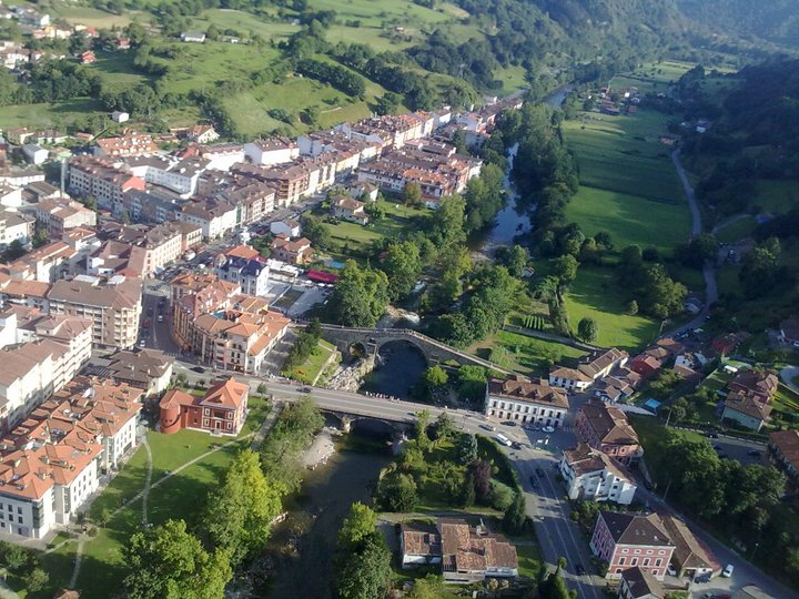
Stage 14: Cangas de Onis - Alto de La Cobertoria, 189km

2pzivef.png


i1cis8.png


GPM:
Collado Arnicio (cat.2) 9,6km @ 5,9%
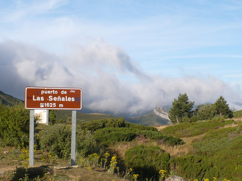
Puerto de Las Señales (cat.1) 18,2km @ 5,2%
Puerto de San Isidro (cat.3) 14,7km @ 2,5%
Collado Puerco (cat.1) 7,8km @ 9,6%
Alto de La Cobertoria (cat.ESP) 9,9km @ 8,8%

With zero transfer from yesterday's stage we head into the penultimate weekend with another HC mountaintop, which though one of the Vuelta's most well known summits has never been a mountaintop finish from this, its most difficult side. No need to continue on from the summit to Gamoniteiru, this is hard enough in its own right.

As things stand, the stage is all about the last couple of climbs, but it's not an easy stage before that, just that the climbing is more gradual and less hellacious. The first ascent is a Vuelta staple in east-central Asturias, Collado Arnicio, which I also used as an early-stage climb in my stage to Angliru in my third Vuelta (which could also have copied this stage as far as Cuchu Puercu if I was a bit more sadistic). The last five kilometres averaging over 7% mean it's not easy, but its function here will only be to ensure a decent composition to the breakaway, I think.

3248506.jpg


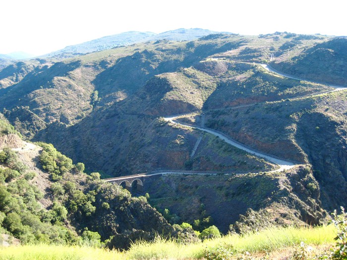
Descending from this, we take one of those long, drawn out, lopsided climbs that run from the low mountains and lead up to the high plateau, much as Orduña, Escudo, Sía, Estacas de Trueba, San Glorio, Palombera, Pajáres, Ventana and Somiedo do (also Pontón, which we descended yesterday). Some of these are genuinely tough climbs (Escudo for its steepness, the second half of San Glorio, Pajáres is highly historic as well), but many are relatively gradual, and so it is with today's climb, the Puerto de Tarna. Luckily for us, above the Puerto de Tarna there's a little extension in the northern Leonese mountains shortly after the crossing (at Tarna) between Asturias and Castilla y León, enabling us to continue climbing for a few kilometres up to the Puerto de Las Señales. Apart from a kilometre at 8% on a relatively early ramp, this is pretty consistent; no kilometres after that initial rise top 7%, and the max is just 10%. This is a perfectly wide and commonly used road; only the last few kilometres from Tarna to Señales will provide any real issue on that side of matters - and even then, the riders use far, far worse roads all over Europe. These are fine.

se%C3%B1ales.png


After descending into Puebla de Lillo, the riders have the easiest, most gradual ascent of the day, to the Puerto de San Isidro from by far its easier side. San Isidro is another of those lopsided climbs as we're now headed back into Asturias; the name is probably familiar to you all from the 2008 Fuentes de Invierno (named for the ski station off a trunk road at the summit) stage, which was won by Alberto Contador after he and Levi Leipheimer sucked Ezequiel Mosquera's wheel as he dropped all but the Astana duo, before popping out to take the stage with 200m to go, causing Xacobeo team boss Álvaro Pino to explode (not unjustifiably) with disgust. Here, there will not be any such action, as the difficult side is instead used as a tricky technical descent leading up to our final chapter, as all of the important action here will be in the final 40km.

puerto-san-isidro.jpg


Just before the riders arrive in Pola de Lena for the first time, however, there is a surprising "no puntable" climb. Realistically, we should categorize the Alto de Carabanzo, as it is 2,2km at 9,4%, a very serious climb as noted on this profile. It was also the final climb of the day in the 2013 Vuelta a Asturias first stage, just a few kilometres from the finish in Pola de Lena, a stage paved in greatness, for it was the site of Amets Txurruka's first career win. The aim here is to have riders a little off-guard before heading through Lena for the first time before starting the double act that will break the race apart.

4886916.jpg


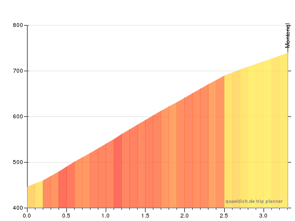
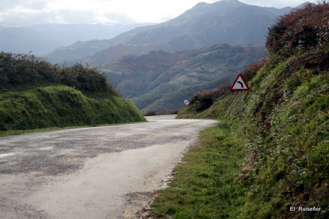
Pola de Lena, realistically, should be to the Vuelta what Cortina d'Ampezzo is to the Giro, or Briançon is to the French Alps. It is a hub from which a great many mountains can be accessed. To the south, the road forks with the Puerto de la Cubilla, an unused grind of a climb nicknamed the Spanish Galibier, to the west and the storied Puerto de Pajáres (plus its extension to Cuitu Negru) to the east. To the north it can be appended to Carabanzo which can be introduced via a number of other climbs. To the west of Lena, there is the Alto de La Cobertoria, from its hardest side. To the north there is the mid-length but steep Alto del Cordal. These two climbs are connected, however, by a third tough road which heads along a mountain ridge ascending above Cordal and rejoining the Cobertoria road a little before its summit. This is the Collado Puerco (known better by its Asturian name, Cuchu Puercu), and it's an undiscovered potential Vuelta beast.

Cuchu+Puercu+$28Cobertoria$29.gif


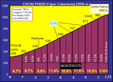
Like many climbs around here, Cuchu Puercu has many sides, but here is arguably the toughest. It includes the toughest part of the Cobertoria ascent, the 5km at over 11%, with a final kilometre after splitting with the Cobertoria road onto a smaller, narrower road at over 9% as well. This may be seen as an unusual way of going about drawing a GT climbing stage, with two times the same ascent only not going quite to the top the first time, however it's not uncommon in Spanish racing. The Tour may have utilized the format with a loop with Alpe d'Huez in 2013, however the Vuelta has used this exact format in the past, for example in 2008 with the La Rabassa stage with Coll de la Rabassa first and Naturlandia hosting the summit finish; also it is the format used repeatedly in the queen stages of two of the main Spanish short stage races, both the Alto de Ixua preceding Arrate in the Vuelta al País Vasco, and the Pasil de Rozavientos preceding Lagunas de Neila in the Vuelta a Burgos. Therefore I have no concern that this will be an unusual or unacceptable course design to the likes of Guillén. Also, the short and sharp nature of the climbs around here mean that the summit is just 22km from the line, even though for the most part the biggest GC riders will likely wait for the final climb given how steep it is. Half of that is taken up by the tricky descent via the Alto del Cordal, the last 5,5km of which average nearly 9% but has been descended in the Vuelta in both 2014 and 2015.

Alto+del+Cordal+%25285%2529.jpg


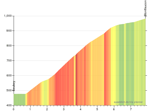
After this, an intermediate sprint in Lena, and then it's on to the famous Cobertoria climb... but like with San Isidro, the Vuelta has only ever used it as a summit from the opposite side (most recently used in 2006, when the Kazakh Bonnie and Clyde did their thing, with Vino winning but Valverde defending the maillot oro with Kashechkin in 3rd). They only recently discovered that, actually, for years they'd been descending the side they should have been climbing, owing to some absurdly hard gradients in the middle.

cob_pol_14.png


tuiza18.jpg


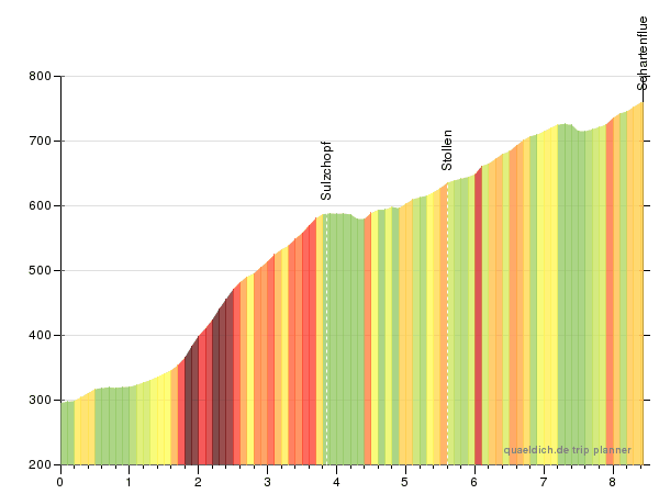
5,2km @ 11,5% in the middle there! A max of 16%! No, it's not the Zoncolan. But it is similar to Giau, but with an MTF. But also proving beneficial to the spectacle is that the last couple of kilometres are much easier, so you can't leave it late to attack here. It's hard enough that it should be breaking people up and meaning it becomes a race of attrition even if riders are conservative; but after Cuchu Puercu the riders will also have had a look at the steepest parts and know what they need to do as well. This may well be a one-climb stage, but there should be plenty of spectacle on that one climb. Especially as fans will hopefully crowd the toughest part of the climb, seeing the riders twice.
 

TRENDING THREADS