Stage 4: Radovljica - Bled, 211km
GPM:
Vršič (cat.1) 11,4km @ 6,9%
Kolovrat (cat.1) 11,0km @ 7,5%
Bohinjsko Sedlo (cat.1) 13,0km @ 6,0%
Pokljuka (cat.1) 10,8km @ 7,2%
The queen stage of the Tour de Slovénie circles around the Gorenjska and Goriška regions; the latter part of the Littoral region along the Italian border, and the former the heart of the Julian Alpine region and including some of Slovenia's most beloved tourist attractions. The stage is between two of these, the preserved medieval centre of Radovljica and the lakeside beauty spot of Bled. There's actually less than 10km between the two, however we're getting from one to the other via a long, mountainous loop with four category 1 climbs.
From Radovljica we head through the valley toward the Italian border, via the railway border town of Jesenice, where the trains for Austria split away. Before we get to Italy, however, we reach the Alpine skiing resort of Kranjska Gora, one of the eight million scenic spots in the region.

The town serves as the base for a wide range of skiing, and is indeed an annual host of the Alpine Skiing World Cup; there is a large network of runs around here as far as the mighty mountain pass that we're headed for, some way from the small town that Kranjska Gora itself actually is. It is likely that a break will already have formed by this point, but if it has not then a very strong escape will be likely to form on the first climb of the day (and if it has, there will be counterattacks for sure) - the most mythical ascent in Slovenia (Mangart is not used in the national Tour, for pedants), the highest pass in the country and a mighty climb in its own right, the savage Prelaz Vršič, known to Italians as Passo della Moistrocca and Germanophones as Werschetzpass. The climb has
sections of cobbles and spectacular scenery, along with some savage gradients including the last 6km averaging over 9%.
It has featured as a mountaintop finish in recent Tours de Slovénie, although Trije Kralje has seemingly taken that mantle recently; Radoslav Rogina beat the 21yo Jan Polanc there in 2013, Nibali won in 2007 and Przemysław Niemiec in 2005, so there's pedigree. Vršič also serves as the boundary between Gorenjska and Primorska (Littoral), where we take on a very technical and similarly steep descent into the Trenta valley, which leads us to the city of
Bovec. Turning right here could lead us into Italy via the Passo del Predil or to the mighty summit of Mangart, but we have more work to do; instead we continue in the valley roads to
Kobarid, where the road will turn uphill once more into a brutal ascent close to the Italian border, to the summit of the Kolovrat ridge, a steep ridge that separates the two countries with two parallel roads along it, close to Monte Matajûr. The name of the ridge is the same as that of an old Slavic sun-symbol which resembles an eight-headed swastika; it has, especially in Russia, unfortunately been appropriated via neo-paganism by nationalist and far right organizations, especially following the racist thrash metal band of the same name. Anyway, that's more than enough attention given to such unsavoury people, I'd much rather talk about the mountain. The ascent is
rather two-stepped, consisting first of the
5km at nearly 10% into Livek, then a km or so of false flat, then another 5km at closing in on 8%. After a brief plateau there's a similarly steep descent although with
relatively fresh tarmac this may be narrow and technical but shouldn't pose a problem. After the descent we don't actually go into the nearby town of Tolmin but instead take a smaller, shorter route into the valley we're headed for, via the spectacular small town of Most na Soči (Bridge on the Soča).
From here we briefly head through Notranjska to get to the base of our third climb of the day, with the third and fourth backing directly into one another. While I may have described Kolovrat as being slightly two-stepped, there's no "slightly" about Bohinjsko Sedlo, which consists of
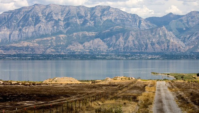
about 6km @ just under 7% from Podbrdo, then a descent, then another 6km @ just under 7% to the summit. With the summit coming at 46km from the line and that 2km @ nearly 9,5% approaching it, this could be where the first moves in earnest are made, although I expect the main GC contenders to wait until the final climb; the likes of Nibali may however consider a move on the descent, unless the riders are too transfixed by the views, for all the way down the descent the riders will have a perfect view down to the "other" great lake of Slovenia, the mighty Lake Bohinj. Larger than Lake Bled, it is less heralded but hardly less scenic and serves as yet another of the great attractions of the country. And who doesn't like a scenic Alpine lake?

From the base of the descent, in the town of Bohinjska Bistrica, we have the final ascent of the day, and it's a savage one, an inconsistent one, and yes, of course those of you who've been around the forum a while knew exactly what it would be... the Pokljuka Plateau. This scenic plateau sits in Triglav Narodni Park, in the shadows of Slovenia's eternal national symbol, and is best known to the outside world for its vast expanses of Nordic trails and, of course, more than anything, the World Cup
biathlon centre at Rudno Polje. Fabled for its difficult trails and its comparatively high altitude for a Nordic venue in Europe, it is one of the smallest venues on the World Cup circuit, but is popular with athletes for its challenge. It also throws up some surprising results sometimes.
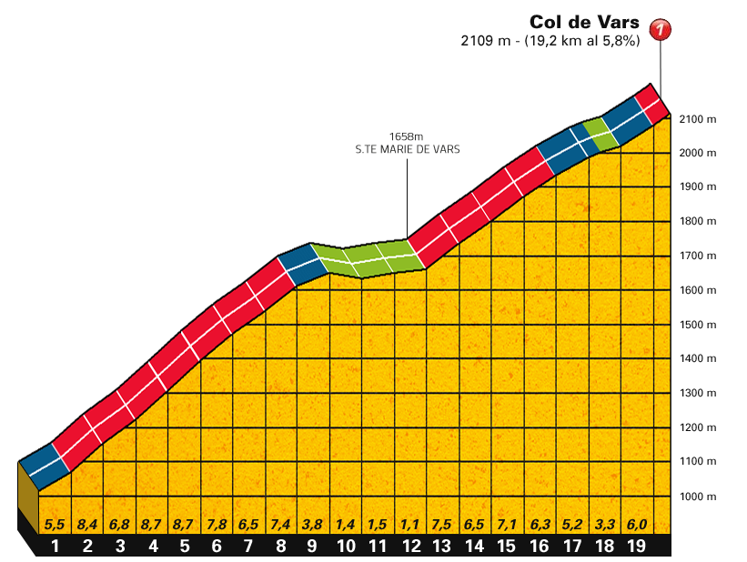
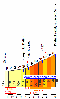
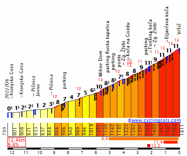
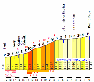
Unlike what you may have expected, however, I'm not putting the stage finish at the biathlon venue - in fact we're not quite going to it. We are taking the hardest of the three ways up to the plateau (one from Bled, two from Bohinj), via the narrow roads through the village of
Podjelje. This is an inconsistent and tricky climb that belies its fairly standard (11km, 7%) statistics, as you can see from the profile:
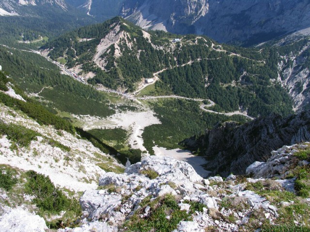
With maximum gradients of 19%, these slopes should really break the race apart; the summit is at 21km from the line, most of which is descent, so this is where to go for it. In particular on the middle section of the climb; after an initial 1600m at around 7%, a flat kilometre or so leads into 3km at an average of around 11% and a steepest kilometre of 13% - certainly no laughing matter. There's then a flat period before two more kilometres averaging around 8-9% with some ramps of up to 15%; it then becomes more benign before flattening out, then ramping up to a final 500m at 7%. No fun at all, except for those of us who get to look at the views. The descent is
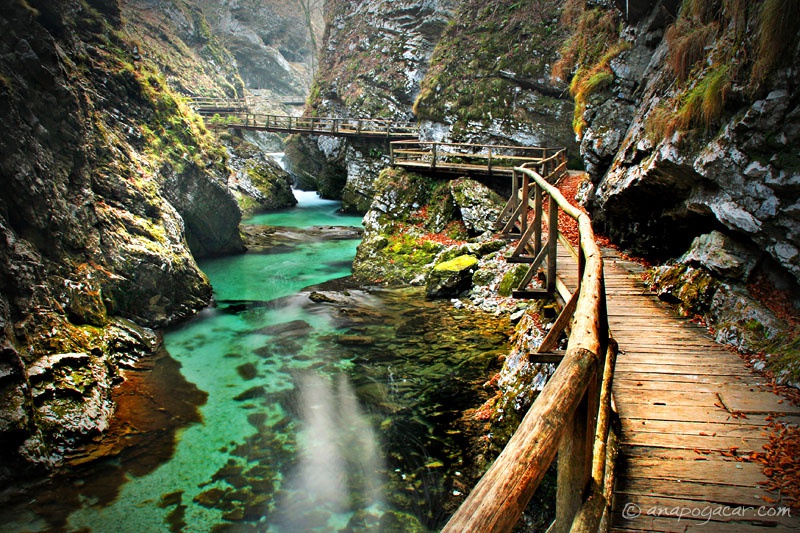
initially wooded before giving way to sweeping vistas of the valley below; there are some steep sections in the middle of the descent but much is relatively benign. The steepest ramps are 18%, so riders will have to watch out for those. We pass a few sights on the way down, for example in Spodnje Gorje the riders will cut away from the road down to the absurdly pretty Vintgar Gorge.
I have, however, extended the descent slightly, mainly as after Spodnje Gorje you could go past the LipBled industrial park straight past the castle into town, but where's the fun in that? Instead, the riders will hang a right and pass the small
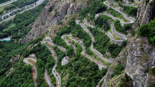
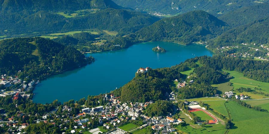
Bled Jezero (Lake) station, allowing us to circle around the side of Lake Bled itself on its southern tip, giving perfect views of
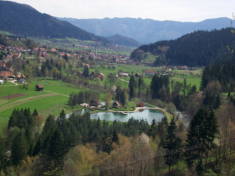
the island and basically going all around the top half of the lake as shown in this picture:
For a view from the other side,
this photo will show what the riders are dealing with, starting bottom left and circling the lake anticlockwise to the top right. The finish will be on the slight uphill drag of
Ljubljanska Cesta.
With over 200km, four cat.1 climbs and such ludicrously good scenery, this one should be a treat. And with the race carefully set up by the ITT and the puncheur finish, and with just one stage to go, this one should see plenty of action. And if it doesn't, hey, let's just send out the helicam.