• The Cycling News forum is looking to add some volunteer moderators with Red Rick's recent retirement. If you're interested in helping keep our discussions on track, send a direct message to @SHaines here on the forum, or use the Contact Us form to message the Community Team.

    In the meanwhile, please use the Report option if you see a post that doesn't fit within the forum rules.

    Thanks!

Race Design Thread

Page 200 - Get up to date with the latest news, scores & standings from the Cycling News Community.
Re:

Brullnux said:
@Libertine Seguros:
I really liked the pursuit idea but what happens when some people are s/t? I imagine a TTT-esque starting ramp might be in order?

In Nordic Combined and Cross-Country, they line the whole startlist up pre-race, usually three abreast, so that when athlete number 1 starts, athlete number 4 steps up to the start gate behind them, and when athlete 2 starts, athlete 5 steps up behind them. There's a five second beeping countdown (like we see in ITTs) before the start, and then a new one for each starter, with a different sounding beep for each athletes' start time (so that athletes less than 5 seconds behind the last don't miss their start time) In biathlon, the same principle is in operation but they start four abreast rather than 3, and they don't have a time beeper after the first athlete is away; athletes are expected to know their start time and set off accordingly, accruing a minimum 30" penalty for starting early (decided by race juries, some are stricter than others).

Athletes in the "wave" set off at the same time, but if you're further down the standings, you're further back in the queue so you get held up a bit by others before you, but that's less relevant since times will be adjusted at the end and they're only in the wave because they're a long way down the GC anyway.
 
Giro d'Italia

first week
(Mon) rest day
(Tue) stage 9: Siena - Terni
(Wed) stage 10: Spoleto - Recanati
(Thu) stage 11: Jesi - Urbino

(Fri) stage 12: Fano - Ferrara, 186 km

ZKoGy9v.png

4lT0VWN.png


Situated between the sterrato stage and the Alps lies this flat stage into the the Po valley. This obvioulsy should be one for the sprinters, if they don't mess it up like in Forli last year. The finishing straight on the Viale Cavour is one kilometre long.

Fano
2dkmUZK.jpg


Ferrara
hkGns4w.jpg

jGOGJW7.jpg
 
Great courses! I truly enjoy them. I'm waiting for w52 to finish his TdF before I post my second Vuelta de Francia as someone here dubbed my first edition. It's ready to go. Still mountainous, somewhat more traditional, but many twists guaranteed. Including this "retro" last stage finish:
 

Attachments

  • Stage 21 - 1974.jpg
    Stage 21 - 1974.jpg
    83.1 KB · Views: 745
Jun 30, 2014
7,060
2
0
Visit site
I've also finally finished my first real Tour de France, I'll start posting it in February, right now I have to finish an important paper.
I've also finished my 3rd Österreichrundfahrt/Tour of Austria, maybe I'll post it before the Tour.
 
Re:

Mayomaniac said:
I've also finally finished my first real Tour de France, I'll start posting it in February, right now I have to finish an important paper.
I've also finished my 3rd Österreichrundfahrt/Tour of Austria, maybe I'll post it before the Tour.
Let me know if you want to go before me. And I'll post my Tour de Franche-Comte first/instead ;) .
 
Jun 30, 2014
7,060
2
0
Visit site
Re: Re:

Tonton said:
Mayomaniac said:
I've also finally finished my first real Tour de France, I'll start posting it in February, right now I have to finish an important paper.
I've also finished my 3rd Österreichrundfahrt/Tour of Austria, maybe I'll post it before the Tour.
Let me know if you want to go before me. And I'll post my Tour de Franche-Comte first/instead ;) .
No, please go first.
Libertine, you can probably understand why I created a 3rd Österreich Rundfahrt, there are just way too many awesome climbs in Austria.
 
The thing with the Österreich Rundfahrt is that, as Mayomaniac points out, there's simply TOO MUCH choice. Everything's too close to one another to be able to do a full GT's worth of routes, but so much of the country is so heavily mountainous that you're spoilt for choice, and cutting a route down to 8 stages without making it absurdly mountain-fetishist is really difficult. In addition, many of the options are dead-end monster ascents to ski stations with known ascents like the Kitzbüheler Horn, Rettenbachferner and so on, but also climbs as yet undiscovered by pro racing such as Idalpe, Hochsteinhütte, Steinplatte or Lienzer Dolomitenhütte.

The other issue is that the Österreich Rundfahrt goes head to head with the start of the Tour de France, which limits its broadcast opportunities and the field, but it does mean that you quite often get some interesting results. Because of the broad range of options and the weird formatting of the race (all too often starting with its most brutal stages and then petering out in the second half) I've had a great many goes at the race, but trying to come up with a cohesive route has proven difficult; I needed something to work with to tie it all together, create some kind of theme to apply that would give the race an identity aside from being a collection of almighty monolithic ascents in Austria.

Over the past few days I've been watching the Tour de Ski. Obviously any of you who haven't by now worked out that I'm a massive mark for wintersports in general, and XC skiing and biathlon in particular, must not have been paying much attention; I did a Giro del Trentino based on XC and biathlon (albeit mostly omitting the Val di Fiemme, rather criminally), my Tour of Norway was similarly an homage to those finest of sports, I have included Pokljuka in my Tours de Slovénie, my Deutschlandtours have been a veritable travelogue of Nordic venues, Laura in my Tour of Russia, Sansicario in a Giro... the list goes on. And obviously the Tour de Ski itself was produced under the influence of cycling, with the organizers even meeting with RCS in order to discuss the nuances of stage racing to see how best it could be applied to XC skiing. So time for a bit of cross-pollination, as the Tour de Ski reflects back into cycling in my Österreich Rundfahrt.

Österreich Rundfahrt

Stage 1: Sankt Anton am Arlberg - Lech am Arlberg, 21,6km (Serienrennen)


290s96b.png


28rzhy0.png


Climbs:
Arlbergpass (cat.2) 7,0km @ 7,2%
Flexenpass (cat.3) 2,1km @ 7,2%

Yup, it's a stage based on my second least favourite XC skiing format (the least favourite is the execrable Team Sprint, a format which has literally no reason to exist outside of exhibition events), the sprint. I'm not the first to introduce the concept of a series race in cycling to this thread - Lupetto has done so twice, in fact, once in the same way that I introduce it, as a replacement for a prologue or team time trial on day 1 of a long stage race (in their case a GT-length Tour of Japan), and then two semitappes in an experimental Tour Méditerranéen. You will also of course be aware that I like to reference or adopt unusual racing formats, something that has come from my fascination with Eastern Bloc cycling and the Peace Race - my Deutschlandrundfahrt included a TT+pursuit at the Nürburgring and a relay race, while the pursuit has resurfaced in my Liechtensteinrundfahrt and Tour de Slovénie, plus the crits with generous time bonuses in the Liechtensteinrundfahrt. But back to the series race. This unusual format of racing has also been seen professionally - the 1988 and 1989 Vueltas featured such races on stage 1 as a faux-prologue.

Now, a word on the logistics of this. The good news on this is that underneath the Arlbergpass is a tunnel, so the disruption to traffic would be minimal as the only people disrupted would be those literally on the race route, in which case the disruption is no more than a time trial would cause; the other thing is because of the large loops around the mountains getting team cars moved around could be problematic; the tunnel helps things, because once a series race finishes, that car can then drive back over Flexenpass and return to Sankt Anton via the tunnel, thus not disrupting the following race. Each series race will have only one service car per team required. An alternative would simply be that as there would only be 16-20 riders in each race, neutral service only.

13-StantonOrt_%20Foto%20Julia%20Boyn.jpg


You see, my thinking is that the Österreich Rundfahrt is actually a pretty perfect race to experiment with; as it's going head to head with the Grand Départ, it needs to do something unusual to grab audience attention. Series racing would fulfil that, no doubt. I would suggest that, much like a time trial, teams will simply choose which of their riders go in which heat, 1-8, but they don't get to know what other teams have chosen. Or, alternatively, the riders draw lots, 1-8. Either way we end up with 8 short races including one rider from each team, which when totalled up will match up to a normal stage length!

Racing in such a style will create unusual situations. There will be 3, 2 and 1 seconds bonus at the intermediate, and 10, 6 and 4 at the line in EACH heat. Therefore you'll have GC riders having to consider whether they should stay with the group to conserve energy with the stages to come and risk losing time in the overall if other stages are faster, or attack and try for a Riis at Sestrières move, gaining time but potentially being more fatigued than somebody who was able to sit in the group in a faster heat - and with two sets of mountain primes available (points available for fastest times between the intermediates) and for the points classification at the intermediate there are other incentives. In addition, chases could well be disorganized in slower heats if riders feel that the chance of leading the GC is gone, and with points for that classification in all of the heats that could become important. Will the weather change, leading to all the teams wanting their leaders to go in the best conditions? What if your leader finds themselves with a bunch of rouleur domestiques with no interest in the stage while other leaders are drawn in the same heat and work together to set a fast time? The implications are many. How about a small Austrian domestic team whose durable sprinter gets drawn in a stage with no fast men in it but enough useful climbers he can stay with to get a good pace and, with time bonuses, a day in yellow? Or from somebody with overall GC ambitions, they may work to set a fast time and not mind somebody sucking their wheels, but somebody else keen on the financial incentive for winning the heat may slow theirs down if somebody's sucking their wheel in that fashion.

800px-St._Anton_am_Arlberg1.jpg


Once we get past the concept of the series race, what we have is a short and difficult stage with two significant obstacles, aimed at trying to split time gaps left right and centre and already splinter the GC before the more "normal" road stages to come in a more interesting and unusual way than a prologue or team time trial.

The start town of Sankt Anton am Arlberg is, as with many places around these parts, tied in with skiing, but unfortunately for me it's that strange, silly type of skiing where you don't go uphill or strap your heel into the ski (!); having hosted the Alpine Ski world championships in 2001, and the World Cup most years (not this year due to lack of snow), it is a world renowned ski resort town, and sits at the base of one of Austria's best known mountain passes, the Arlbergpass.

ArlbergE.gif


You can see from that profile that Sankt Anton is around 7km from the end, slightly less in fact; we do a little loop around the town for the start so what we actually climb is from the 7km mark. It also means we have a stage which is scenic from the start.

arlberg1.jpg


After the top of the climb, the riders then descend the first few kilometres towards Stuben and Klösterle, but swiftly turn right to take on the last couple of kilometres of Flexenpass, which as you can see includes a kilometre at 8,5% finishing at the 6,7km to go mark; the descent is very straight and fast and corresponds to the final 6km of this profile.

csm_3500075_26_7973335c6b.jpg


The descent features some noteworthy tunnels, but they're the sort that allow plenty of light in and shouldn't cause any trouble especially in small-sized groups such as these. The finishing town of Lech am Arlberg is also a picturesque skiing resort town, and this one quite a renowned and expensive one as well. This will be a fascinating and bizarre first stage; I would anticipate a finishing time for each race of somewhere around 35-40 mins, so eight of these would total around 5 hours, most of which would feature something of some interest (how fast is this heat running over the Arlbergpass? How will the as-it-stands GC be affected?), which is more than we usually get. Fairly long, but still, if it can get on early enough to get some coverage before the Tour (or for highlight packages to be edited together quickly enough for broadcast after the Tour stage) it will help, right?

lech8_02.jpg


Is it a bit gimmicky, a bit artificial? Absolutely. And I would be absolutely apoplectic if it took off and became more than a once-in-a-blue-moon kind of event unless it became a staple of one particular race giving it a kind of identity with the stage (the same way as the one-off Mount Fuji Hillclimb is now a staple of the Tour of Japan). I remember saying to Lupetto way back when that I don't even particularly like the format in XC skiing (although it's more FIS' abject overuse of the format that rankles with me, it's supposed to be cross country, hence the name. In 2013-14 they accounted for almost half the calendar, with an almost equal split of "sprint" and "distance", the latter accounting for anything from 5km to 50km in distance!!!) .But would it be interesting to see how this type of stage could work in modern cycling? Absolutely. And would it not make most sense to try it in a race where the field is strong enough for it to work but, given it's competing against the Tour, if it doesn't work it can be quietly retired without much hassle?
 
Critérium du Dauphiné by railxmig - opening post

I'm extremely lucky person. After 3 months i managed to end my try at Dauphine to acknowledge that LS just begun his/hers/its 10km 10% climbs parade and other well respectable users: Tonton and Mayomaniac will post their races. I think i will need to fight for this meat and up myself to the challenge. My lack of knowledge in french geography, culture, heritage and still abysmal knowledge of english language are definitively not helping here. I hope for a proper, honorable fight and that your races will be as best as they only can be.

Below is a list of the stages of my Dauphine that i will be completing when each stage will be posted. The list additionaly will have links to every post with the stage so finding such stage should be easier and it (i hope) should be easier for LS to it's Race Design Thread library. Every stage post should have a link to this post to keep some sort of communication between each post.

Stage: start – finish, length, type, difficulty:
1. Villars-les-Dombes - Parc des Oiseaux, 10km, ITT **
2. Bourg-en-Bresse - Aillons-Margériaz, 213km, Mountain MTF *****
3. Chambéry - Bourgoin-Jallieu, 169km, Medium Mountain **
4. Villefontaine - Vienne, 40km, ITT *****
5. Vienne - Saint-Marcel-lès-Valence, 155km, Flat *
6. Portes-lès-Valence - Sanctuaire de Notre-Dame de la Salette, 181km, Medium Mountain MTF ****
7. Le Bourg-d'Oisans - Bourg-Saint-Maurice, 162km, Mountain *****
8. Beaufort - Grenoble, 153km, Hilly *

Overview:
1. Villars-les-Dombes - Parc des Oiseaux
buhb9uE.png


2. Bourg-en-Bresse - Aillons-Margériaz
BwRsjBw.png


3. Chambéry - Bourgoin-Jallieu
B5wIsnP.png


4. Villefontaine - Vienne ITT
nC9F3iN.png


5. Vienne - Saint-Marcel-lès-Valence
Mk0PAB4.png


6. Portes-lès-Valence - Sanctuaire de Notre-Dame de la Salette
yyleTte.png


7. Le Bourg-d'Oisans - Bourg-Saint-Maurice
KRObo8w.png


8. Beaufort - Grenoble
ByIL1qL.png


Departaments:
Ain, Drôme, Isère, Rhône, Savoie, Haute-Savoie

Introduction:
This is my first stage race I decided to publicize. I'm not extremely happy with the outcome but I'm not cringing either. This race has it's flaws and design mistakes but I don't want to change the race for like 5th time and come up with even worse design. I'm not either French or English so my english language and french geography are quite abysmal, i'm sorry in advance.

I've created this Dauphine as a run-in to my try on Tour de France that is under construction since 2013. Thankfully Dauphine is not as restricted to roads and cities as TdF (thanks TdF 2016, big thanks to you buddy) so I can be at least slightly more creative with my choices and start/finish places. I've tried to make a realistic race, but with some flavour of wildness in design and unorthodx solutions. How it ended up? I'm fine with the stages but i'm worried they are not the most realistic (or challenging obviously) in the world with some roads propably being unable to hold a race (some short and apparently used by Tour and Dauphine, but dodgy unlit tunels and maybe closeby protected sites). I know that to design a stage you don't need to be realistic, but my plan was to be at least partly realistic.

I tried to not use any of "easy" climbs like Mont du Chat, Grand Colombier, Cyclotouristes, Bisanne, Alevard MTFs, Luitel, Parquetout etc. They were reposted so many times that i consider using them (or at least in obvious ways) as lame as most of Vuelta MTF stages nowadays.

My descriptions of the stages will be kinda bland and concentrated on the road and difficulties of the stage rather than touristic values, history and cyclists. It just takes too much time to research. I just don't know and don't have any interested in where some random spanish climber no different to other random spanish climber had his first teething or where a german biathlonist had his first gas excretion. Actually it sounded funnier in my head...

Outside stage 1 (too short to write tons of useless stuff) i will try to have my descriptions clear and clean. Those walls of text will be parted into couple of subparts. At the beginning i tried to give some damn into touristic values in given stages but soon i've realised it's a time consuming chore so i decided to limit them just to short lists with couple of jpgs slaped on. I tried to mark the quality of roads, climbs, start, finish, sprint and feed zone exact locations, stage's purpose, possible outcomes, alternatives and optionaly more intersting ideas.

Stage categorisation:
Stages will be categorised by an estimated amount of uphill meters. I've calculated them myself as i didn't count every uphill stretch in the stage, only the significant or visible ones. So, if there is a very bumpy stage but with max cat. 4 or 3 climbs then the estimated uphill meters can be much lower than the tracking device is showing.

I've separated stages into four categories:
1. flat – <1000m uphill,
2. hilly – 1000m – 2000m uphill,
3. medium mountain – 2000m – 3500m uphill
4. mountain – >3500m uphill.

This categorisation can be changable. It depends on location of the climbs/hills. The closer the climbs are to finish line the stage will have a chance of higher category.

Short description of the race:
Statistics:
Flat/Hilly Stages: 2
Medium Mountain Stages: 2
Mountain Stages: 2
# of Categorized Climbs (Cat 2, 1, HC): 16
Summit Finishes: 2
ITT: 50km
TTT: 0km
Overall Distance: 1085km
road stages medium length: 172km
acumulation of uphill meters: ~15000m
begun: 10.10.2015
ended: 10.01.2016

Previous races:
2015: 1214km, 16 Cat. (25km TTT)
2014: 1189km, 19 Cat. (10km TT)
2013: 1138km, 14 Cat. (32,5km TT)
2012: 1052km, 11 Cat. (58km TT)

My Dauphine is the shortest one since TT heavy 2012 edition and reduces the accumulated amount of tranfers to around 220km. This edition has slightly less TT kilometers – 50km compared to 2012's 58km and more climbs – 16 cat. 2 or more compared to 2012's 11 cat 2 or more. The race will visit 6 departaments: Ain, Drôme, Isère, Rhône, Savoie, Haute-Savoie. Stages 2, 3 and 6 will partly contain roads that will be in my Tour. Most of the stages are similiar to those present in my Tour.

There will be 5 start/finish sites that propably are new to Dauphine. There are two MTFs, both propably new to the race, with the one on stage 6 being the hardest. There will be only 3 HC climbs with only one of them being a proper HC but to compensate there will be a fair amount of cat. 1 and 2 climbs. Interesting fact is that there are less cat. 4 bumps than cat. 3. There are technically much more bumps that could be categorised but i either rejected them or didn't bother to categorise to keep my profiles kinda clean and easy to read.

The race will start with obvious 10km prologue/short TT in Parc des Oiseaux and end with the classic south side hilly stage to Grenoble. This Dauphine will tackle a fair amount of new roads with basically only first stage being entirely on known roads.

Climbers should be among contenders for overall classification thanks to the accumulation and difficulty of climbs in stages 2, 6 and 7. The time trial should however nerve a bit pure climbers in favour of those that have some skill in TT. I don't think that pure TT-ers, punchers or baroudeurs will have a chance in winning the GC.

Fight for the sprint points can turn to be interesting as most of the sprints will most propably be contested between breakaways and there is not enough sprints or MTFs to favourise one type of a rider. I think if somebody's willing and will have enough luck to be in a couple of breakaways then he can try to at least be a contender to win the green jersey.

Short description of upcoming stages:
Stage 1 is a 10km prologue/TT, flat and straightfoward with only 5 turns (two 90-degree). It should be won by a prologue or TT specialist. The differences shouldn't be big.

Stage 2 is the first mountain stage ended with cat. 1 MTF and difficult last 50km. It's propably for the first time this MTF is in Dauphine. It's the first important day for the riders targeting GC. Riders planning on Tour should look out for the first couple of kms and one of the later climbs.

Stage 3 is a very interesting stage. The first part is quite mountainous, definitely climbers friendly while the second half is flat to hilly. The whole stage however is quite technicall with a chunk of twisty, varied quality roads and complicated finale. It is a stage mostly for baroudeurs especially as the day before is hard, so fatigue will have a vital opinion here. There is however a slim chance of it being an interesting fight between punchers and tougher sprinters. Fatigue will be a very important factor in this stage.

Stage 4 is an ITT. It's a hilly one with 3 hills that could be categorised as cat. 4. The first part of the ITT is straightfoward and technically unchalenging while the second part is the opposite with twisty roads and bumpy terrain. Still this stage should favour TT specialists but thanks to the more difficult second part climbers might not lose as much as they would on a straightfoward course.

Stage 5 is the stage for sprinters. For the rest of the bunch is the day to recover as much energy as they can because next two days will be hard.

Stage 6 is the third important day for GC. It's a medium mountain stage ending on a cat. 1 MTF, propably first time Dauphine will held a stage finish there. The terrain before is very bumpy but with only cat. 2 being the hardest one, so any attacks should be limited only to MTF.

Stage 7 is another mountain stage but this time ending with a descend. Technically it should be the most important stage in this Dauphine with 4 big climbs and last climb being 10km from the finish line. The descend is actually quite straightfoward and not that steep with 6km at 6% and a plateau on the top of the climb. Last kms could either be the one crushing any attack attempt or providing a good place to gain more time than on a more difficult descend.

Stage 8 is a classic parade to Grenoble. This time it's the south variant with Col Barioz. It will be a very similiar stage to the one in 2013 edition with only minor differencies. It shouldn't be GC relevant.

I'm not 100% happy with the outcome but i think more drudgery would only worsen the effect. I will see, how long it will take to post one stage, so i will see if i can be fast enough to post one stage a day. And please, be polite. It's basically first time i ever publicized a stage race and stage descriptions not counting that classic race in Brittany. Have a good day.

Rejected idea:
I was thinking of posting something before, but i finally rejected it. I was thinking of something like a l'Avenir one-day prep race from Albertville to Beaufort contesting extremely favourised here Val Doron climbs of Cyclotouristes - Bisanne - Plan du Chuet (east of D218 Arêches - Beaufort road) - Col du Pré - Col de Méraillet - Beaufort. The race would be something like a points race with separated timed sections. Every fastest rider in each of the sections would have like 100 points or something and at the end those points would be summarised and the winner would obviously have most points. Sections would be like uphill to Cyclotouristes, another section would be downhill from Cyclotouristes, another one uphill to Bisanne and so on. In last section 100 points would go to the fastest rider in that section and the rider who first crossed the finish line. Then second on the line and second fastest in that section would have like 80 points and so on.

Example:
At Cyclotouristes there would obviously be smaller groups of riders. At the top the fastest would win 100 points. The race does not stop here but goes on. Differences and groups stay the same like in a normal race, but each of the riders have their times reseted. Then the fastest on the descend section will have 100 points even if he is in groupetto. It would be like a mass start in first section and then onwards each section would be like a pursuit race until finish line. I warn you that i'm not a cross country specialist of big of a fan either. Sometimes i watch but i'm mostly a casual fan.
 
Critérium du Dauphiné by railxmig - stage 1

Library: click here

Villars-les-Dombes - Parc des Oiseaux ITT, 10km, ~15m asc

AH2hhc4.jpg

buhb9uE.png


start: Villars-les-Dombes, Avenue des Nations
finish: Villars-les-Dombes, Parc des Oiseaux
departament: Ain

A small technicality before I get to the topic. I personally don't like uneven numbers so I always have a tendency to threat TTs of 10kms or less as prologues. I will count this stage as a prologue but in reality i think it would be a very short TT.

My Dauphine enters with a borderline prologue/TT around Parc des Oiseaux. The region is very flat and perfect for a TT with most of the roads being long, two-lane straights. This region seems to like working with ASO in last couple of years so I'm quite confident that such a prologue might happen in real life.

The stage begins in Villars-les-Dombes on Avenue des Nations. Villars-les-Dombes is a town/small city located in the centre of Dombes known for it's ponds. You can find there a castle mound known as poype from X century (now overgrown) and obviously a church (Église de la Nativité-de-la-Sainte-Vierge) with surroundings taken straight from middle-ages.
Fh9QFzB.jpg


The stage is very flat and straightfoward with practically only 5 turns in span of 10kms. After leaving Villars-les-Dombes riders turn into D2. After 2kms there is a slight right turn and after another 2kms riders turn 90 degree right into slightly narrower D2D (theoretically still two-line road). After another 2,5km or so riders turn right into D1083 where they will have another wide, flat 4km straight with very small right turn halfway that will lead them to the finish line in Parc des Oiseaux. Is is a bird park located close to Villars-les-Dombes, known allready from Dauphine and Tour.

Purpose of this stage? A simple show act to see all riders, give somebody the jersey and maybe attract more time trialists to the rooster. Stage favourites? Propably TT specialists, either long TT or prologue specialists. GC significance? Propably non unless you're Piepoli or Landa.

I think that's it for today. Stage is short and there's just not much to write as it's not GC significant and the road is mostly wide, stright and flat. Next stage however will be the first one for the GC as it'll be a mountain stage. There will be no Biche-Colombiere combo. It's a fine combo but it's just overused. The stage will end in a MTF, propably new to Dauphine.
 
Jan 13, 2014
898
0
0
Visit site
Vuelta de Argentina 2016 - Santa Cruz

For a long time i've a fan of this thread and track editors, but because of my awful english i didn't post a route/race until today (and not because i improve my language skills).

I'll try to make various editions of (in the real life defunct) "Vuelta de Argentina". Now in a more realistic aproach as 3 day early season race, every year held in a different region.

2016vamap.jpg


For the 2016 edition the race will be held in the south-west part of the Santa Cruz province. An important tourist destination, home of the Los Glaciares National Park. The lack of roads, pavement and towns complicate the design of the parcour... anyway here we go!

Stage 1 - Glaciar Perito Moreno (ITT) 13.2 km

A back to back 13.2 ITT, from (and to) the Glaciar Perito Moreno lookout through a winding road, with soft rolling hills.

2016va01.jpg
 
Critérium du Dauphiné by railxmig - stage 2

I've tried to put some description but it balooned to an elaborated mess so i decided to screw this and just post an abstract of it.

library: click here

Bourg-en-Bresse - Aillons-Margériaz, 213km, ~4050m asc, Mountain/MTF

50bwHAF.jpg

BwRsjBw.png


Start: Bourg-en-Bresse, Avenue Paul Barberot
Km 0: Bourg-en-Bresse, Avenue Amédée Mercier, 3,5km from the start
Finish: Aillons-Margériaz, ski station, parking
Sprint: Oyonnax, Rue Jules Michelet, 450m straight
Feed zone: Bassy, Route de Challonges

Start - km 0:
Avenue Paul Barberot - Boulevard André Lévrier - Avenue Maginot - Rue du 19 Mars 1962 - Place Bernard - Cours de Verdun - Rue du 4 Septembre - Boulevard de Brou - Boulevard Saint-Nicolas - Place du Maquis Colonel Romans Petit - Avenue Amédée Mercier

List of climbs:
Col de Berthiand - 6,4km, 8%, 1 Cat. 780m
Côte de Samognat - 4,5km, 5,4%, 3 Cat. 634m
Côte d'Échallon - 8km, 5,3%, 2 Cat. 970m
Côte de Franclens - 4,4km, 4,3%, 4 Cat. 522m
Côte de Marcellette - 2,5km, 5%, 4 Cat. 493m
Mont Revard - 17,6km, 6,6%, HC Cat. 1463m
Col des Prés - 8.8km, 7,1%, 1 Cat. 1142m
Aillons-Margériaz (Stade de Neige du Margériaz) - 6,3km, 8%, 1 Cat. 1400m

Departaments:
Ain, start - 91,2km
Haute-Savoie, 91,2km - 148,7km
Savoie, 148,7km – finish

Preface:
Even if its just the 2nd stage it's one of hardest if not even the hardest stage in this race. It's the longest stage and the only one beyond 200km of this Dauphine. This stage is filled with mountains, hills and bumps. There are hardly any really flat sections – around 30kms of those. This stage can be separated into three parts:
first part – 0km – 73km. It's in the Jura mountains so it's obviously very bumpy. In span of 70kms there are three categorised climbs with cat. 1 being the toughest and a number of hills that could be categorised. It ends where the 3rd climb's descend ends;
second part – 73km – 155km. It's the flattest part of this stage and arguably the most touristically attractive. There are only two cat. 4 climbs in this part but not many really flat parts. It's still a bumpy terrain.
Third part – 155km – finish. It's the most montainous part as the stage goes through Massif des Bauges. It now goes fully into a real mountain stage as there are three climbs in quick succession, no one of them is below cat. 1.

Purpose:
It's the first stage of this Dauphine and it's allready very important to GC. It's purpose is to create as big gaps as there only can be between GC favourites, show off, who's lagging behind in prep and promote those, who actually were preparing for and targets Dauphine. Outcome of this stage can limit the risk of crashes in following stages. The stage does share some roads with my planned Tour so riders can adapt to them beforehand combining training and road recognition.

Start:
Stage will start in Bourg-en-Bresse on Avenue Paul Barberot. Bourg-en-Bresse has very rich history with cycling races. It hostes a lot of stages in Tour and Dauphine. Most of them were hilly parades through Jura (Faucille, Croix de la Serra, easier Berthiand etc.). It will start the Culoz stage in 2016 Tour with Berthiand from much harder side. The km 0 will be on Avenue Amédée Mercier [D979], 3,5km from the start. To reach km 0 peloton will follow:
Boulevard André Lévrier - Avenue Maginot - Rue du 19 Mars 1962 - Place Bernard - Cours de Verdun - Rue du 4 Septembre - Boulevard de Brou - Boulevard Saint-Nicolas - Place du Maquis Colonel Romans Petit.
D32qzYU.jpg


Bourg-en-Bresse:
bAvGjCV.jpg

photo: Emilio Bertrand, 2013

Climbs:
Most of the climbs on this stage are known from Tour and Dauphine but are tackled from, most often, descended sides. Interestingly those sides are often harder than the more popular ones. Below is a list of categorised climbs to tackle and their short description.

Col de Berthiand (780m). The first climb of the day close to Montagne de Berthiand (836m) is 6,4km at 8%. It's a borderline 1/2 cat. I've promoted it to a cat. 1 because the first 2kms are very tough at 11%. Such percentages are quite rare on big and quite important roads (we're still on D979, Bourg-en-Bresse – Annecy road). Next kilometers towards the summit are progressively easier to flatten out on top. I think that profile below isn't most accurate but it's the only one i could find.
J3rpduE.jpg


Côte de Samognat (634m). It's located just west of Oyonnax. It's 4,5km, 5,4%, that makes it a cat. 3 climb. It's quite consistent with slopes in between 5% and 6%.

Côte d'Échallon (970m) begins just after Oyonnax. It's a cat. 2 climb, 8km at 5,3%. It is simillar to the climb before, it's consistent with slopes in between 5% and 6% though first stretches still in Oyonnax are steeper. After the summit there is a small plateau before a long, shallow descend. It was present in Dauphine and Tour a bunch of times.

Côte de Franclens (522m). Climb simillar to Col de Berthiand but obviously shorter and shallower. It is a cat. 4 climb – 4,4km, 4,3%. It begins steep with 2km at 6,3% and progressively flattens towards the top.

Côte de Marcellette (493m). It's a cat. 4 climb, 2,5km, 5%. It's an opposite of it's predecessor. It begins as a false flat and progresively steepens towards the top with last km at 5,5%.

Mont Revard (1463m). There will be 3 climbs in this Dauphine that could be categorised as HC. This is the first one. It's a borderline 1/HC, promoted to HC because Dauphine is a smaller race. In Tour it would propably be a cat. 1. It's 17,6km at 6,6%. It's mostly a consistent climb with only one 1km long flat plateau in Trévignin 5,5km from the base of the climb. Most of the climb is between 7% and 8% with max. being 10%. It flattens on the top with 2km at 5,5%. The climb begins in Grésy-sur-Aix, just north of Aix-les-Bains and joins the main road (D913) in Trévignin. I think this side was never tackled in real Tour but will be partly present in my upcoming Tour. I don't know about Dauphine but propably not as this is the least known/popular side of this well known climb. Part of this climb up to Trévignin was present at the beginning of 2013 Dauphine stage 5 to Valmorel as a cat. 3 Côte de Trévignin, 4,4km at 6,6%. Last 1,5km in profile below are not included.
JEUfd0X.gif


Col des Prés (1142m). It comes just after Monte Revard. It's much shorter than it's predecessor but steeper and less regular. It is a cat. 1 climb, 8.8km at 7,1%. This climb begins steep with 1km at 7,5% (max 10%) before reaching village of Thoiry. Then it slightly flattens for next 3km before again going steep with 3km at 8,5% (max 12%) before reaching last flat km. Descend of this climb is short and quite shallow. This climb quite regulary features in Tour and Dauphine, last time in Tour in 2013 from the different side. Part to Saint-Jean-d'Arvey in profile below is not included.
xcWK7so.gif


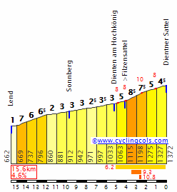
Aillons-Margériaz (Stade de Neige du Margériaz) (1400m). This is the MTF of this stage up to ski station Aillons-Margériaz. It comes after Col des Prés with 3km flat section in between. It is a cat. 1 climb, 6,3km at 8%. This climb is hardest in the middle with 2km at roughly 10%. First 2km are at around 8,3% and last 2km are flatter at 6,5%. I don't know if this climb featured in either Tour or Dauphine, i couldn't find any information about it. Propably it was in Dauphine in more historic times. Only last 6km of profile below are included.
hEMcaH4.gif


Besides the climbs listed above there are plenty of other hills and bumps that are borderline into categorisation or just left uncategorised. Worth mentioning is Col de la Roche (400m) located a couple of kms before Col de Berthiand. It is 1,4km at 7,2%. It could be a borderline 3/4 cat. It isn't categorised because there are enough categorised climbs on this stage and its location is unfortunate. Being close to Col de Berthiand and start of the stage proves for me to be problematic to put in the profile while not losing it's clarity. In real-life Dauphine or Tour it would be categorised and knowing the downward trend of categorisation nowadays it would be a cat. 3.

Sprint:
Today the sprint will be held after 52,2kms in the city of Oyonnax on Rue Jules Michelet at the end of 450m straight road. The road is two-lane, 6m wide. The sprint will be situated around 150m before railroad cross. It should be safe enough to not pose any or too much logistical problems. If not, then just move it like 100m before and it shouldn't cause any safety problems. The sprint should be won by a breakaway or a strong sprinter/fast puncher.

Feed zone:
Feed zone is located just outside town of Bassy on Route de Challonges after 102km from start, just before Seyssel.

Finish:
Finish will be held on the ski station Aillons-Margériaz (Stade de Neige du Margériaz is a parallel name) on top of a 6,3km, 8% climb. The station is in shadows of Mont Margériaz, 1845m (Massif Aillons-Margériaz). In the station is a triangle-shaped parking space at around 4000m^2. The space is approximately as big as was in Superdévoluy in 2013 (my own estimations using satelite view). It should be big enough to at least hold the most important cars and installations. I'm not sure if the buses could squeeze there and i don't see any closeby space to put them. Maybe just left them on D59 as it is a two-line road. I don't think it would pose much logistical and transport problems as this road doesn't seem to be of most importance or traffic heavy.
kV2NkPx.jpg


Roads:
Most of the roads are two-lane and their overall quality should be enough to hold a cycling race. There are some stretches that are narrower. There is almost two-lane, 5km long D31 Alby-sur-Chéran – Gruffy (135-140km), occasional narrowings in D14 Val-de-Fier (110-115km), a kilometre long D31 Pont de l'Abime – one-line around 3,5m wide (142-143km), and eventual narrowings in towns and cities. It makes less than 15km of roads narrower than a two-lane wide. The road to the finish, judging from satelites, is propably two-lane.

This stage uses 40kms of red roads (important ones that should be limited as much as possible for cycling tours) separated into three stretches: D979 Bourg-en-Bresse – Annecy road from 0-33,5km, D979 from 72-78km and D1201 from 134,3-135km. The stage doesn't interfeer with any autoroute or express road's junctions.

I'm not sure if I actualy can use Val de Fier as it can be a protected site, might collide with the dam and there is some risk of flooding or rock avalanches. All tunels are either short galleries or short and lightened so there shouldn't be much trouble with them. If there will be any problems with the road then I have prepared an alternative route via Vanzy – Frangy – Côte de Bossy (cat. 3 climb on D910 road) – Clermont‑en‑Genevois to link the roads in Vallières. I hope that there won't be any issues with Gorges du Sierroz.

Possible outcome:
Because it's the first stage of this Dauphine, amount of points to get for points and climbers jerseys and the first part of this stage being hilly, propability of a large breakaway is very high. The breakaway's size can cause a very hectic first kms with possibility of peloton breaking apart on Col de Berthiand. The race should slow down after either Col de Berthiand or on Côte d'Échallon (because sprint in Oyonnax) with the breakaway of non-contenders going away for 5-7 minutes.

The flatter central part of the stage should be used to slow down after the first part and to reorganize/prepare for upcoming difficulties. Propably somewhere there the TV cameras will be turned on so some of today's attractions could be shown. Difference to the breakaway can be at around 3-4 minutes.

Mont Revard is long and regular. It should be a good warm up for the last kilometers and provide big passive selection. On the top there could be around 30 riders in the peloton. Just as the descend ends Col des Prés begins. It can be either continuation of the selection up to like 15-20 riders at the top, stabilisation or first shy attacks by GC second tier contenders. I think propability of such attacks being succesful is quite low. Those two climbs should warm up the legs for the Aillons-Margériaz MTF looming ahead. The attacks for the win and GC propably will be around 4-3kms to the finish as those are the hardest moments (10%) on this climb. Last two kilometers are easier, so differences made by the attacks should at least hold.

Let's think about the most propable scenario. Differences between top 10 should be moderate – around 1:30 between 1st and 10th. Difference between first two at around 20-25sec. I think that 20th guy should be barely inside 5:00 mark and grupetto aroud 40 minutes down. Presence of the Jura climbs at the beginning could pose problems for some riders in trying to keep the loses inside time limit.

Tourist attractions:
Ceyzériat (6km) – Cascade de la Vallière
q7UGHyt.jpg


Hautecourt-Romanèche (16km) – Grotte de Hautecourt.

Izernore (37,2km) – important town in the Gallo-Roman era. It was one of the main towns of Bugey region (Grand Colombier). To this day there is a preserved Gallo-Roman temple.
uJzZuOm.jpg


Samognat/Metafelon (42,8km) – Barrage de Matafelon, Sauts de Charmine
3lGYLCK.jpg


Barrage de Génissiat (91km)
NVqDBQW.jpg


Seyssel (107km) – an interesting place as it's disjoined by Rhône river where the border between Haute-Savoie and Ain departaments is located. That's why officialy there are two Seyssels, the biger one in Haute-Savoie and smaller one in Ain.
Barrage de Seyssel – smaller than neighbouring Barrage de Génissiat, it's used to regulate the flow of the Rhône after Barrage de Génissiat.
Église Saint-Blaise de Seyssel – from VI century,
Pont de Seyssel – suspension bridge from 1838, one of the oldest of it's kind.
5FmfXzW.jpg


Vens (110km) – Château de Vens – stronghold used in history to protect the entrance to Val de Fier and was the home to lords of Vens.

Val de Fier (110-115km) – propably the most beatiful attraction we encounter on this stage. It's a sight more typical for Pyrenean valleys. I don't think it's as pretty as the, quote, FEDAIA!!11oneone one (#libertine_s #steve_harvey #meat_missile #tickle_my_pickle) but it's not that far away. It's located between Montagne de Gros Foug (known for Mont Clergon and Col du Sapenay) on south side and Montagne des Princes on north side. On both sides the almost vertical drop is around 650-700m high with the river at roughly 270m and both plateaus over 900m. The road is slightly uphill and it goes through some galleries and one 100m long, lightened tunel. It has a varied width, most narrow (1,2 lane wide) around Barrage de Motz. It's a dam on Fier river just after the tunnel. The original road through Val de Fier was build by Romans. The valley ends after 5kms in Saint-André, a village belonging to Val-de-Fier commune. The road below is where the race will be held.
2mK6xgW.jpg


Val-de-Fier (115km) – to Val-de-Fier belongs Saint-André and Sion (2kms down the road) that is known from Romans times as Sedunum. In Saint-André you can find ruins of a church from V century while in Sion is Château de Sion from XIIIc. Attractions: Château de Sion, ruins of Église Saint-André.
z1DtVmb.jpg


Vallières (121km) – Pont Coppet – old (XVIIc.) stone bridge on an ancient Geneva – Chambery road.
h1pOl4Y.jpg


Alby-sur-Chéran (135km) – in middle-ages was a part of a defensive system controlling the passage of Chéran river. In the commune there are six castles/strongholds: Le Châteauvieux, Château de Montconon, Château de Montdésir, Château de Montpon, Château de Montvuagnard, Château de Pierrecharve.

Gruffy (140,5km) – Château de Gruffy from IX century. Le Mollard – remains of human presence dating from the Neolithic period.
QM99TyQ.jpg


Pont de l'Abime, 545m (142,9km)
zeYCGoQ.jpg


Gorges du Sierroz (151,5-154km) – part of Val de Sierroz just outside Grésy-sur-Aix. Popular tourist destination in XIX-XX century, closed in 1980, now a protected ecological site with a bunch of rare plants.
F5dsz8A.jpg


Grésy-sur-Aix (154,8km) – Château de Grésy – former stronghold from XIIc., Château des Contes de Loche, Château du Fontany ou Fontanil, Château de Mouxy, Église de Saint-Jean-Baptiste.
ZzVhsJ9.jpg


Mont Revard (173km) – Belvédère du Revard – outstanding views; too many photos to post here.
 
I really like Libertines idea of a such a stage. I think this would be quite interesting. Moreover I think there will already be very big time gaps because some gc riders will really be completely on their own.

I also like the second stage of the Dauphine. Extremely hard and 3 great climbs at the end, directly after each other.
 

w52

Aug 2, 2015
139
0
0
Visit site
Nice stages here in the last couple of days. I will try to finish my TdF.

Tour de France

Stage 15: Thuir - Ax-3-Domaines (173.2km)


et15_173_2.png


et15.png


In the Tour de France we are now in the end of week 2, and this Sunday will not be an easy one to the riders. Stage 15 is synonymous of MTF, the third of this Tour, in the cat.1 of Ax-3-Domaines, in a 173km jouney that starts in Thuir, where stage 14 finished in the day before.

Like i previously mentioned, the stage starts in Thuir and the first 30km will be in false flat until the first climb of the day in the Col de Jau. This climb is long but is not the steepest the average gradient is +/- 5%, it will be a nice warm up for the remaining of the stage

jau.PNG


Stage continues after the top of Jau with a long descent that will bring the riders to the last 90km of the day, that will be full of difficulties with 4 climbs without any kind of flat terrain. The first climb of the menu is the very well known Col de Pailheres, an hors category climb and the most diffficult of the day with it's 11,5km at 8.7% (from Mijanes)

Col_de_Pailh_res_Mijanes_profile.jpg


Instead of the typical combo Pailheres-Ax-3-Domaines, this stage will have two more climbs after Pailheres. The first one is a cat.2 in the Col de Ladauri (6.3km 7.7%), this climb is not very long but is steep and the road is narrow, being ideal to a long range attack, once the group should be short in number after Pailheres.

Sem_T_tulo.png


After the descent of Ladauri (in the same narrow roads of the ascent) we have a non categorized climb followed by the cat.4 of Col de Chioula

col_du_chioula_prades_profile.png


Finished Chioula there is a long descent to Aix-les-Thermes, where we finally start the ascent to Ax-3-Domaines a recent climb in the Tour, thar were used for the first time in 2001. Last time this climb was used in the Tour was in 2013 in a stage won by Chris Froome

Ax3domaines.png


In the finish line big gaps are expected, but this isn't the last mountain stage and the time won/lost here is not crucial yet
 
I am amazed, railxmig has managed to put together some posts that make my route posts seem pretty lazy and ill-thought-out, WITHOUT drawing attention to birthplaces of Spanish climbers (who are all unique and different in their own ways) or German biathletes (some of whom are more flatulent than others). Focusing on the cycling route at the expense of a Nordic sports travelogue simply will not do, so luckily I'm here to address that.

Stage 2: Montafon - Seefeld in Tirol, 170km

2v8qrr7.png


b6yp2t.png


GPM:
Bielerhöhe (cat.1) 16,0km @ 6,5%
Tobadill (cat.3) 3,1km @ 8,1%
Pillerhöhe (cat.1) 7,5km @ 9,5%
Silzer Sattel (HC) 9,7km @ 10,4%
Kühtai Sattel (cat.2) 7,1km @ 6,6%
Seefelder Sattel (cat.2) 8,8km @ 6,3%

The Österreich Rundfahrt is seldom shy about putting its toughest stages early on; indeed most years the famous Kitzbüheler Horn MTF takes place on stage 2. In 2013 they even stuck two MTFs on the first two days, one at Kühtai Sattel and one at Kitzbüheler Horn. And with there likely being some noteworthy gaps already owing to the difficult parcours in the series race yesterday, this stage - on the Sunday, so likely going up against a tedious flat stage in Le Tour - should see some action as it is arguably the toughest stage of the entire race (but only arguably), with a serious finish and several difficult climbs.

schruns-tschagguns.jpeg


The opening to the stage is in the town of Schruns, the biggest town in the Montafon valley area, known like most of the area for its ski resorts; it also hosted the ski jumping, XC and Nordic Combined in the European Youth Olympic Festival last year. Montafon consists of eleven villages and resorts, from the valley floor to the summit of the Silvretta-Hochalpenstraße, also known as Bielerhöhe. It is this mighty pass which is the first challenge of the day, and with the road climbing almost from the word go, a strong breakaway is surely assured on these classic slopes.

hochalpenstrasse-silvretta-oeffnungszeiten.jpg


The road as you can see is as pure an Alpine road as you can get; wide open, perfect tarmac, and more hairpins than you could ever reasonably need - topped off with a gorgeous lake backdrop and tough but not too tough climbing gradients. As noted in Gigs' post in the Unknown Climbs thread about Zeinisjoch, however, Bielerhöhe (which featured in the Tour de Suisse last year as the main obstacle before the MTF in the Rettenbachferner stage, and serves as the main viable alternative to the Arlbergpass in the area) is one of those massively lop-sided climbs that you sometimes see in the area (the other really notable one for me being Staller Sattel) where one side is just false flat and the other is a legit cat.1 or more. This means that the break will need to use this downhill false flat to consolidate the advantage built up on the climb, and the race will likely settle back down a bit on the long downhill towards Landeck. Before we get there, however, there is a short punchy climb into a smallish hilltop village called Tobadill; this will break up a bit of the rhythm ahead of the intermediate sprint in one of those classic Germanic valley-floor towns that dot this part of the Alps.

D_Landeck_Sommer.jpg


Following the intermediate, the road immediately heads uphill again. Pillerhöhe from this side (it has several) is much shorter than Bielerhöhe - less than half its length in fact - but at 9,5% for over 7km it is a force to be reckoned with and earns cat.1 status, comparable to Cuchu Puercu or a tougher version of Ax-3-Domaines/Bonascre. It's windy and much narrower than Bielerhöhe, and should cause some difficulties but ultimately is far enough from the line to prevent too much carnage.

treffbild.php


Again, we descend a much more gradual side of the climb before a bit of rolling valley-floor terrain leads us to the grandest stage of the... er... stage: the mighty Kühtai Sattel, split into two because we're going via the almost inhumane Silzer Sattel side. According to quäldich, the total climbing insgesamt here is 19,2km @ 7,7%, however as the Österreich Rundfahrt likes to break up these multi-stepped climbs and, well, we are dealing with two clearly definable separate climbs, I have categorized them separately... and still given HC status to the Silzer Sattel. That's because this mighty, savage brute of an ascent averages around 10% for 10km (slightly more for slightly shorter).

SilzerN.gif


Say hello to the Austrian Mortirolo, or actually realistically one of about 35 Austrian Mortirolos. It's not as long as its Italian counterpart (the statistics of the Mortirolo actually match up nigh on perfectly with the Rettenbachferner, but that can only be an MTF), but there's not the respite after it if you go with the same styled stage climbing to Kühtai - it's narrower and more savage than its predecessors, 2km longer than Pillerhöhe and even steeper whilst totally exposed to the July sun. I expect to see pure attrition here as lots of domestiques fall apart. Cresting with 47km remaining, this will be agonizing, and leaders who are left alone now will have a lot of defending themselves to do.

Except it doesn't really crest then, because there isn't the traditional respite of a descent, instead only 2km later the road switches back up again for the final 7km of this side of the Kühtai Sattel, one of Austria's best-known climbs, and which features a toughest kilometre at 10% early on - much as with Aprica, this may actually break the field apart more than Silzer Sattel as those tired legs scream for mercy rather than climb some more with so little respite after such a monster.

irzwaende-2777-m-2757-m-und-der-hochalter-2678-m-kuehtai,7767222.jpg


The Kühtai Sattel from this side has been given 2nd category, although it's somewhat easier than the final climb which has the same categorization. However altitude and the predecessor climb (plus the Österreich Rundfahrt tendency to over-categorize secondary summits, such as Hochtor after Fuscher Törl getting cat.2) leads to that categorization; the climb crests 38km from home, and then a long, sweeping descent begins. We pass the valley turning for Axamer Lizum, which hosted the Alpine Skiing at the Innsbruck Winter Olympics and featured as an MTF in my Deutschlandrundfahrt; however we sweep past it. We're honouring a different venue from those Olympics today, because we descend all the way to Zirl after which the road turns skywards one last time for a mid-length climb which, from its average gradient, wouldn't seem that imposing.

76755426.jpg


However, there are some brutal ramps of over 20% in the first few kilometres of the ascent - in fact, the first 3km of the ascent average 10%, before it ramps down toward false flat as you can see on the profile. Therefore we can expect the moves to be early on and then riders fighting to stay with it as the road eases up; turning uphill again at such steep gradients will be a real shock after the long winding downhill following the brutal Silzer Sattel/Kühtai Sattel double act, and then the final climb crests 2km from the line, with a short flat run-in to allow Steve Cummings to catch the local attackers ;)

B_seefeld_luftbild.jpg


Seefeld in Tirol is another of those beautiful towns that you often see in this part of Austria, linking chocolate box scenery, painted housing, a very Germanic brand of Catholic art and architecture, and idyllic backdrops... but also plenty of scope to hold the race thanks to the broad range of wintersport infrastructure here meaning hotels, space etc.. Seefeld is where the Nordic disciplines (except ski jumping) took place in the Innsbruck Olympics, and to this day it is one of Austria's most beloved spots for cross-country, with dozens of kilometres of perfectly groomed Loipe (making the assumption of course that there is snow, which this winter is quite a large assumption to make!!!); a large and high-tech biathlon facility for the Austrian team to train at and for the public to try out has been opened at the town in recent years, and was used for the Youth Olympics in 2012. And of course, every year (weather permitting, once more), the Nordic Combined World Cup shows up in town to utilize the Loipe and also the Toni-Seelos-Schanze in town (which hosted Normal Hill competitions in the Innsbruck Olympics, as opposed to the large hill competitions at the Bergiselschanze, on the outskirts of Innsbruck itself). So plenty of sporting heritage, plenty of scope for great racing, plenty of great scenery. The GC should be all over the place after just two stages.
 
Jun 30, 2014
7,060
2
0
Visit site
Great stage, I didn't expect the stage to end in Seefeld, I always thougth that Silzer Sattel-Kühtai Sattel was the perfect combination to have at the end of a stage, but it's a great option.
My Österreich-Rundfahrt starts in the easter part of Austria, has the ITT on stage 3 and the hardest road stages later on.
 
Aug 21, 2015
380
0
0
Visit site
Looking forward to a lot of the races soon to be posted. I am done mapping my 2 week Tour of California but I still have to tidy things up a bit so it will be a while. It is not the most realistic race but I wanted to show off some of the great terrain in the state and I think I succeed at doing so.
 
Re:

Mayomaniac said:
Great stage, I didn't expect the stage to end in Seefeld, I always thougth that Silzer Sattel-Kühtai Sattel was the perfect combination to have at the end of a stage, but it's a great option.
It's only stage 2, and there is method in my madness...

Stage 3: Innsbruck - Bischofshofen, 191km

35a21vk.png


zlptz5.png


GPM:
Gerlospass (cat.1) 25,3km @ 3,8%
Filzensattel (cat.3) 3,1km @ 8,9%
Dientner Sattel (cat.3) 4,1km @ 6,4%

What's going on should now be becoming clear as I unleash the first weekday stage of the race, a somewhat easier affair which I can get away with, because the Österreich Rundfahrt takes place in July, and therefore a certain execrable excuse for a human being who may or may not be World Champion will be likely racing in France and therefore not winning this, a stage which would seem well-suited to him. And the race is the better for it, of course.

Innsbruck and Bischofshofen are of course both intrinsically linked due to the Vierschanzentournee, or Four Hills, the most prestigious annual ski jumping event, with four large hills over the course of a week or so (the other two are in Germany, for those not aware - Oberstdorf and Garmisch-Partenkirchen), complete with a unique head-to-head knockout style of determining the second round; as a result you may see an unusual result here and there but typically the good will out and only the very best are consistent enough to take home the overall trophy; cases of one-hit-wonders like 2013-14 winner Thomas Diethart, who appeared from out of obscurity, won the Four Hills, had a great Olympics, and then promptly got deposited back there, are rare. More common is last week's winner, Peter Prevc, pretty undisputably the best ski jumper in the world right now. Innsbruck and Bischofshofen are also, rather conveniently, approximately cycling stage length apart, so this one was a no-brainer for me.

innsbruck.jpg


There's a lot more you can do with Innsbruck, perhaps the most famous of all Austria's cities-in-the-mountains, than I'm doing; but I'll leave that for Thomas Rohregger and his proposed World Championships routes. Here we're taking a transitional eastward stage, mostly through nice flat valley roads which will serve as a wonderful respite for the riders after the unusual first stage and the monstrous second one. However, we are still in Austria, and so there are still a few obstacles; the main one on this stage is the lengthy Gerlospass; perhaps overcategorized 1st category, it is long but relatively uncomplicated; it essentially consists of a 2nd category and a 3rd category climb linked by several kilometres of false flat. Even for a relatively benign climb that will only drop the Kittels and Guardinis of this world (you would expect the Swifts, Lobatos and Bouhannis to still be around after this, but many of them will be in France), its length may cause some attrition. It still has its perks: like much of this part of the world, it's pretty impressive-looking.

p1020562.jpg


Here is where a typical Österreich Rundfahrt would move away from here, going over Paß Thurn to Kitzbühel. Or, more likely, they would bypass all introductory climbs entirely and just go straight from Innsbruck through the gradually rising valley to Kitzbühel. But while my route may be absolutely chocked full of wintersports history, the fact that the real race annually uses the city and climb means that I bypass arguably the most famous of all Austrian ski resorts! Instead we continue eastward and head along the shores of Lake Zell.

csm_seecamp_sommer05_ed988fd1a2.jpg


After this we go through Saalfelden, another scenic town which plays host to a well known waterpark and another ski jump. After this, it's time for two short, sharp climbs before heading in to the finish, so as to thin the pack down, tempt puncheurs and attackers to have a go at getting away and try to discourage the sprinters' teams; with the mountainous route and the head to head with the Tour de France, many front line sprinters will not be present, so the strength of the leadouts will be limited giving more chance for escapes to be successful, or so the theory goes.

First up is the wide open Filzensattel and this is soon followed by Dientner Sattel; back to back they crest at 23 and 17km from the line respectively, with the former being the harder of the two, as we do this profile in its entirety:

FilzenW.gif


followed by the last 4km of this one:

DientnerW.gif


We then have this technical descent to deal with including some steep gradients, before a fast sweeping route into Bischofshofen to finish. This one may see opportunities for GC men to take a bit of time, but it's unlikely they'll dare, wanting a bit of time to recuperate after the opening weekend, unless they're a long way down and need to take risks. However, time can be gained especially if the chase is disorganized and a puncheur or Ardennes specialist type rider gets away.

Ortsansicht_Bischofshofen_07_78313074da.jpg
 
Jan 13, 2014
898
0
0
Visit site
Vuelta de Argentina 2016 - Santa Cruz

Stage 2: El Calafate - Esperanza (163 km)

Early in the stage the riders will face the Cuesta de Míguez (10,9 km @ 4,4%). But most important, as soon they leave El Calafate not a single tree in the roadside will be found, and that's bad news because strong winds are very likely. The finish is in the small town of Esperanza, probably a small bunch sprint.

2016va02.jpg
 
Damn, that Österreich Rundfahrt Is great. I Love every Stage so far and every Stage would be Great to watch. I'm already excited how the stages in the East will looke like and I hope either libertine or Mayo will use my beloved Wienerwald an area which is hardly ever uses in the races here (well, except of my races which visit the Wienerwald almost too often)
Btw, I'm a but surprised libertine didn't mention that the Nordic skiing World Championships in Seefeld 2019. :p
 

TRENDING THREADS