lemon cheese cake said:
I started in Le Teil, as the race will only go into the Rhone Alpes region of france. As Avignon and Orange are both in the Vauclause department, I can not start in those two towns. In Hindsight, Montelimar is larger and probalby better to host the grand depart.
I wanted this to be a sort of test event for the Tour de France, so that's why the race finishes there. It finishes just outside the town on the D290 in between the two roundabouts just south of the town.
If I'm as slow at posting this as I am at posting my Deutschland Rundfahrt, then you'll have completed all of the races that the ASO organise, before I get to the Alpes.

I guess that's fair. Wait a sec... Ardèche is in Alpes!? Seemingly it is (checked out wikipedia to be sure). How far does Alpes reach? Pyrenees? I've always thought Alpes reach as far as Rhône. You don't need to post anything, theoretically the race can begin or end wherever you like to, it's your race. I was more messing around finding concepts and options. Sorry if you were offended or sth like that.
Critérium du Dauphiné by railxmig - stage 6
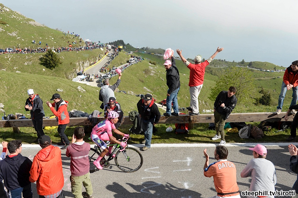
I guess i'll speed up to not conflict with you. I will go more religious today even if i'm not the most religious lad out there. I think i've seen this place in this thread once, so it should not be anything new to the public. It is a controversial place, as there is not that much of available space. Kind of a shame, as it looks like a nice place for a MTF in a medium-size french race like Dauphine or Paris-Nice. Maybe l'Avenir could use this place in real life. It's first of two Alpine stages that should decide the GC.
Library:
click here
Portes-lès-Valence - Sanctuaire de Notre-Dame de la Salette, 181km, ~2200m asc, Medium Mountain/MTF
Start: Portes-lès-Valence, Avenue de la Résistance, intersection with Rue Emile Zola
Km 0: Portes-lès-Valence, Route de Beauvallon, 3,4km from the start
Finish: Sanctuaire de Notre-Dame de la Salette, parking
Sprint: Die, Avenue Sadi Carnot, 550m straight
Feed zone: Aix-en-Diois, Le Prieuré, D539
Start - km0:
Avenue de la Résistance - Rue Emile Zola - Rue Jean Jaurès - Rue Marx Dormoy - Avenue de la Résistance - Place des Droits de l'Homme - Avenue de l'Europe - Route de Beauvallon
List of climbs:
Côte du Recru - 7,1km, 4,9%, 3 cat. 515m
Côte de Chambaran - 4,3km, 4,7%, 3 Cat. 579m
Departaments:
Drôme, start - 104,5km
Isère, 104,5km - finish
Preface:
After a couple of days in Val du Rhône the race comes back to Alpes with a cat. 1 MTF in Sanctuaire de Notre-Dame de la Salette at the edge of Massif des Écrins. The terrain before it is very bumpy with a couple of cat. 2 and 3 climbs but not enough to call it as a mountain stage. This stage can be separated into two parts.
First part. First 80km up to Aix-en-Diois is flat with an uphill tendency, characteristic for stages finishing in Gap. It's where the sprint and feed zone are located.
Second part. It begins with Col de Grimone ascent. Those around 100km are very hilly with 2 cat. 2, 2 cat. 3 and 2 uncategorised ascents. Most of this part will be featured in my Tour de France.
Purpose:
Second MTF of this race. Technically it's around the same difficulty as the one in stage 2. The stage before it is hilly, but propably not hilly enough to shake off less climbing capable GC threats. Climbers should use this stage to take back at least some eventually lost (most propably in TT) time on last MTF and mainly to create a pace hard enough to be feeled on the next, harder day. Next stage is theoretically hardest in the whole race. It might be used for a team like Sky to put the hammer down and unleash their extraterrestial power and tactical prowess, but such scenario is more propable on stage 2. Other purpose of this stage is to create a classic combo of a MTF hard day followed by even harder, downhill finish day.
Start:
Stage will start in Portes-lès-Valence on Avenue de la Résistance close to intersection with Rue Emile Zola. Portes-lès-Valence is part of Valence aglomeration. It's a couple of kms south of Valence. It's growth is thanks to being located on N7/A7, one of the busiest roads in France. It mostly has an agricultural, suburb like architecture but west and north sides are industrial (oil rafinery). Km 0 will be in (practically outside) Portes-lès-Valence on Route de Beauvallon, 3,4km from the start. To reach it peloton will follow:
Avenue de la Résistance - Rue Emile Zola - Rue Jean Jaurès - Rue Marx Dormoy - Avenue de la Résistance - Place des Droits de l'Homme - Avenue de l'Europe - Route de Beauvallon
I don't think it ever hosted any of Paris-Nice, Dauphine or Tour stages before. I don't think this town will ever host any stage in real life. There is actualy quite a chunk of space on Avenue de la Résistance and surroundings that seem to be available and on Place/Rue du 8 Mai a small village could be established (or on this unidentified space between Avenue de la Résistance and Avenue de l'Europe). The alternative start could even be close to this place on Rue Auguste Delaune, Rue Emile Zola or Rue Jean Jaurès. I've chose this place mostly to be original, because stage races seems to like suburban towns that are part of bigger aglomeration and because propably nobody will ever think to put either a start or finish here (same with Saint-Marcel-lès-Valence).
Climbs:
This stage is very bumpy. Some of those hills will be categorised, some missed the mark.
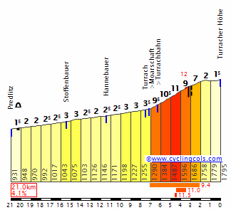
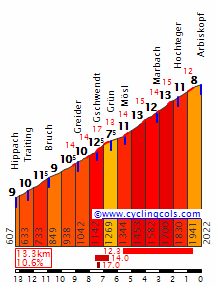
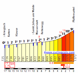
Col de Grimone (1318m). The first climb of the day is a cat. 2 climb – 12km at 4,9%, 97km from the start. It's located in Haut-Diois between Le Jocou (2051m, highest in the region) and Toussière (1916m). It's long and not steep but it's quite irregular with slopes averaging between 3 and max 9%. There are some small plateaus and tougher slopes, but nothing too horrific. Hardest parts are just before and after the village of Grimone.
Col du Banchet (900m). Cat. 3 climb – 2,6km at 6% lying 20km after Col de Grimone. Located in Trièves between Vercors and Dévoluy massifs at the foot of Le Ménil (1594m). Propably not the first time Dauphine sees it. It's tackled from the harder west side. This ascent is quite regular at mostly 6% with 3 serpentines.
Côte du Crozet (750m). Another cat. 3 climb just outside La Mure. It's located 33km after Col du Banchet. It's actualy very similar to Col du Banchet, a regular ascent of 2,6km at 6%.
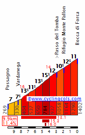
Col de l'Holme (1215m). This, located in the northwest edge of Massif du Valgaudemar between le Chauvet (1705m) and Mont de Rousse (1877m) climb is quite important as it lies just 14km off the base of the MTF. Pace here will most propably be quite high. It's a cat. 2 climb – 6,9km at 5,6%. It's mostly regular, but gets progressively steeper towards the summit, where it reaches a 3km long plateau. The actual KOM will be where the intersection with Col de Parquetout (we're just a couple of kms away from this famous col) road is rather than where actual col is located, 3kms later. At the top there is a 3km long plateau and then a quite shallow but technically tricky descend. It was present at least once in Tour de France and propably a couple of times in Dauphine.
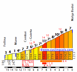
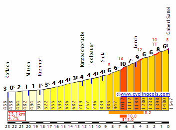
Sanctuaire de Notre-Dame de la Salette (1748m). This is the MTF of this stage up to the sanctuarium. It starts a couple km after Corps and comes 14km after Col de l'Holme. It is a cat. 1 climb, 11,7km at 6,6%. Located in the northwest edge of Massif du Valgaudemar at the foot of Mont Gargas (2208m).
This climb can be separated into three ascents with small 1km plateaus. First climb is up to Saint-Julien village, it's about 3,3km at 7,5% with first couple of meters being the hardest with max 10%. it's actualy the toughest slope of the whole climb. Next ascent is up to Col des Prés-Salés (a 1km after the actual col). It's around 5km at 7,6% and max slope at rougly 9%. It's quite consistent but gets progressively flatter towards the summit. Last part of the climb starts from Col de l'Homme (not to mistake with Col de l'Holme) to the actual sanctuary. It's slightly over 1km at around 9%.
I don't know if this climb ever featured in Dauphine, i couldn't find any information about it. It could be in Dauphine in older times. Because this climb is quite inconsistent it can end up being quite selective and not easy for the diesel climbers.
There are a couple of smaller hills that could be categorised but either just missed the mark or I've just decided to not bother with them to keep the profiles relatively clean. There are two hills that stand out from other bumps.
Col de la Croix-Haute (1179m). It's a very important col – 3km at roughly 4%. It is one of the rare cols that comfortably links Grenoble with Val Durance (Sisteron, Manosque). This, located between Trièves and Haut-Diois col is very important transport-vise as it's on the Genève/Lyon – Marseille E712 road. It's in between Col de Grimone and Col du Banchet. Dauphine used this col in 2015 Costa/Nibali breakaway stage.
Col Accarias (892m). It could be categorised as a borderline cat. 4 climb with 3km at 3,6%. i decided against it as it is almost a false flat. It's located in Trièves at the south bank of Drac river. At the top of this col Château d'Accarias is located.
Sprint:
Sprint will be held after 60,2km in Die on Avenue Sadi Carnot at the end of 550m straight line. Wondering if any of the sprint teams will be eager to maintain a big tempo for those 60 flat kms to give their sprinters any chance for the points jersey as the next stage is not suited for them.
Feed zone:
Feed zone is located on D539, close to Le Prieuré village in commune of Aix-en-Diois after 68kms, 8kms after the sprint and around 18km off Col de Grimone base. Riders should be careful with their eating program as the feed zone is located quite early in the stage (113km from the finish line).
Finish:
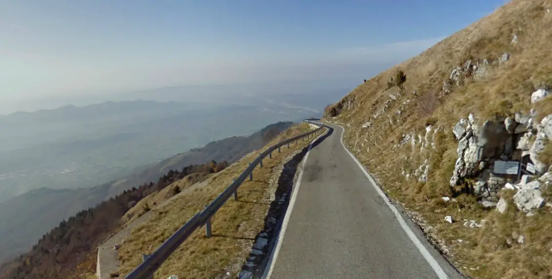
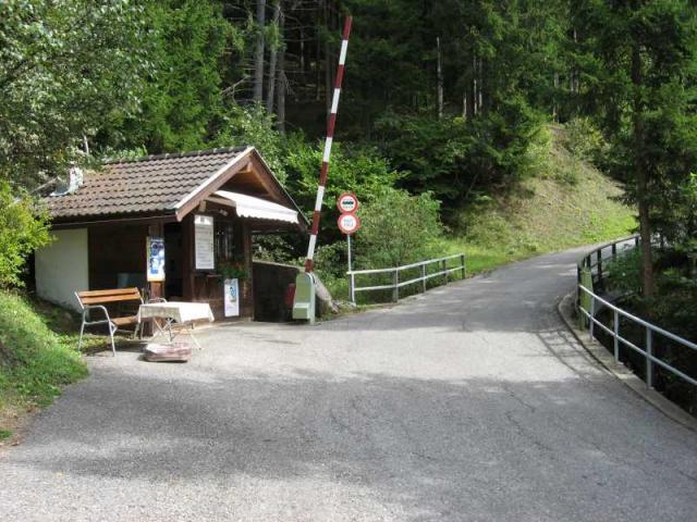
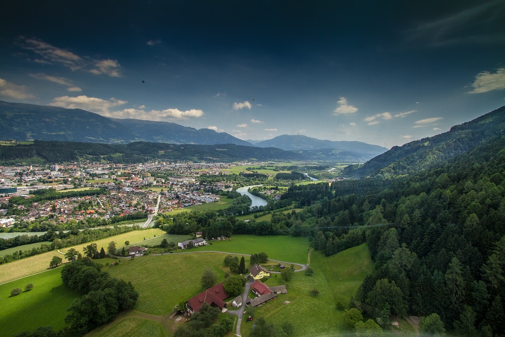
Finish will be held in Sanctuaire de Notre-Dame de la Salette, close to Mont Gargas (2208m) in Massif Valgaudemar, part of Massif des Écrins. it's on top of a cat. 1 ascend – 11,7km, 6,6%. The road up to Sanctuaire is two-lane in a very good surface condition with around half of the ascent (as of 2014) being on a new surface (2 or 3 years old). Maybe right now the whole ascent is on a new surface. Sadly, theres not that much space (only about max 1000m^2). The buses could stay in ex. Corps where there seems to be some space availaible (a small chunk, but i think it once hosted a Dauphine stage before somehow, i don't remember if it was a start or a finish). I'm not sure if la Salette ever been in Dauphine or Paris-Nice before. I kinda doubt it as there isn't that much space but because it's a relatively big tourist attraction so maybe in more historic time there was an actual finish.
Roads:
Most of the time varied terrain means varied road width and quality. This stage is no exception. First 80 km are flat so the roads are wide and in good contidion, outside the towns of course. Most of those kms are on well known from any cycling races D93 Valence – Gap road that was used many times ex. on last year Tour. Those well documented roads end in Aix-en-Diois where the stage turns east into Col de Grimone (D539) and Col de Menée (D120) where the road width and quality are varied.
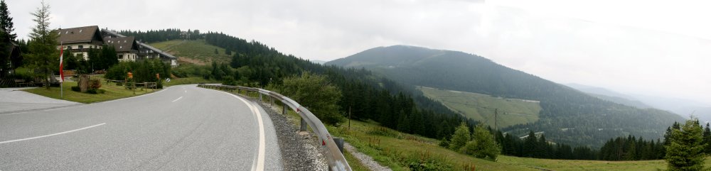
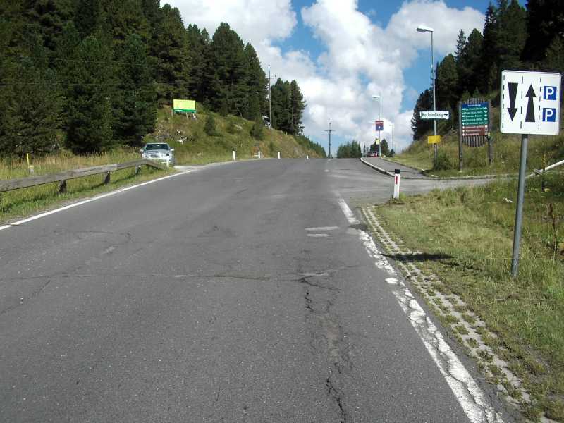
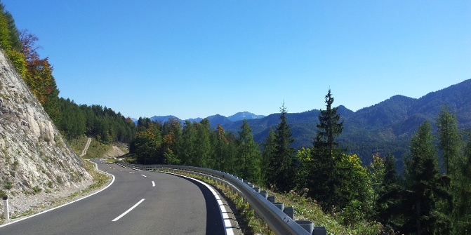
I've had a tough nut to crack as both those cols were present in Tour and Dauphine (last time around 10-15 years ago) but they're maybe not the most suitable of the cols for today's standards. On both of the roads there are some short but unlight tunels. One is on top of Col de Menée, it's around 250m long, on a two-lane road and it's straight, but it's unlightened and 250m for unlit tunel (even if straight) is quite long. On the Col de Grimone road there are a couple of unlit tunels around 10km before actual col with the longest one being around 100m long but they're on a quite twisty and not that wide road. I've decided for Col de Grimone because of the environment (Gorges des Gâts) while Col de Menée road is a regular medium-mountain road. Col de Grimone propably will be in my Tour de France.
The descend from Col de Grimone doesn't have any hazards as it's on a two-lane, medium quality road. Then the stage turns north into E712 for about 7kms. As the name points it's an important european road. I would never decide to use it if not last year's Dauphine where this road plus Col de la Croix-Haute was actualy used. Then D66 (Saint-Maurice-en-Trièves – Mens) and D526 (Mens – La Mure) roads are used. They're mostly two-lane on mostly good quality surface outside of Mens, where quality drops and road narrows (as it's with 90% of french towns). Then the well known Route Napoléon N85 is used up to La Salle-en-Beaumont where the stage turns into D212 road.
It's one of those traceur must known's as it links with Col de l'Holme and famous Col de Parquetout. Obviously Col de Parquetout is out of my reach and i doubt it will ever be in any of the bigger races, but Col de l'Holme has some history with Dauphine and Tour and seems to be accesible. The road is obviously narrower (around 1,3 lane) and it's quality looks dodgy, but still wider and better looking than Col de Parquetout. The descend from Col de l'Holme to Corps is difficult but mostly because of the road's width rather than dificult turns. Most of this descend is quite straightfoward with a couple of loose turns. In Corps the D212C road up to the sanctuary is introduced. It's a two-lane road that has (partly or totaly) a new surface.
This stage uses around 80km of important roads (D111 Valence – Nyons – Avignon, D93 Valence – Gap, E712 Lyon – Marsillie and N85 Route Napoléon), but all of those were used before in either Tour or Dauphine recently so there shouldn't be many problem in using them.
Possible outcome:
Either a breakaway win or GC riders sprinting up this cat. 1 MTF. It should be hard enough to not end in a 10 or more group sprint but i don't think the time differences will be big especially as the whole stage is not the most challenging. Maybe somewhere around 1:00 to 1:30 from 1st to 10th. Pace in the first 60km, where the sprint is located, can be very fast if sprinter teams are willing to work. Rest of the stage should be quite slow. Change of the pace should be propably on the next-to-last climb – Col de l'Holme. Peloton at the foot of the last climb should be relatively big – around 60-man group.
Possible variations:
The most obvious possibility is to use
Col de Menée as a replacement for Col de Grimone. Then propably the stage would go via Clelles crossing with E712 and then D526 straight into Mens to connect with the actual stage. This potential stage would be 180km long with Col de Menée as a borderline cat. 1/2 – 15km at 5,1% but without cat. 3 Col du Banchet. It can be a possible replacement if the tunel on top of Menée will be accepted.
Another obvious (and propably designers favourite) possibility is to use
Col de Parquetout and it's famous last 5km at 11% rather than Col de l'Holme, but not only road on Parquetout is at best barely passable in real life (i think it will never see any of the biger races, maybe l'Avenir?) but i feel like using it would be lazy and repetitive. Col de l'Holme is easier and smaller sister, but is a lot more passable than Parquetout, even if it still would have problems in real life. But if even l'Holme won't pass then just go with Route Napoleon as far as Corps.

If la Salette won't be able to handle the stage then i projected an alternative finish in Superdévoluy. It even could go with the Noyer side as the stage would be something like 210km long with last 30km taken straight from 2013 stage. Even if i would prefer a shorter stage (i'm happy with the one i've managed here – 180km) it still would be passable. Actually, Superdévoluy is one of my favourite climbs as it can be a perfect finish for some really hard, unrealistic monsters like this one i've created back in october 2013:
Geography:
Start of this stage – Portes-lès-Valence is located in Val du Rhône, by the Rhône river just outside Valence in the historic region of Valentinois. Then stage goes west through Val de Drôme in between Massif du Vercors and Massif du Diois into Haut-Diois where Col de Grimone lies. Then north into Trièves – a medium-mountain range where next two cat. 3 climbs are located. Stage then keeps going north-east changing direction into south-east in Crozet just before La Mure. Trièves ends just before Crozet where the stage croses Drac river on D526. After Crozet the stage crosses La Bonne river and enters the north-west edge of Massif Valgaudemar, part of Massif des Écrins keeping close to Drac river. Stage continues for a couple of kms south-east and then in Corps turns east into Valgaudemar and sanctuaire where the finish line is drawn.
Val de Drôme – located in between Massif du Vercors and Massif du Diois. Crests from Crest up to Beaurières at the foot of well known Col de Cabre (1180m) in span of 70km. Main road here is Valence – Gap D93 road. Main locations are Saillans, Die and Luc-en-Diois.
Massif du Vercors – mountain range between Drac and Rhône river. Made mainly of limestone. Mountains here have an apperance more resembling of Jura rather than Alpes. There are a lot of high plateaus between smaller mountain ranges, mostly forested by coniferous trees. Highest peak – Grand Veymont (2341m).
Massif du Diois – mountain range between Vercors (separated by Drôme river) and Barronies (separated by L'Eygues river). Like Vercors it's made mainly of limestone, but their presence is more resembling of Alpes rather than Jura mountains. Highest peak – Le Jocou (2051m).
Trièves – a dale squished between Vercors (west), Diois (South), Dévoluy (South-East), Écrins (East) and Taillefer (North) mountain ranges. It's a medium mountain territory with terrain between 500m and 1000m a.s.l. The climate here is particulary dry for it's altitude.
Massif Valgaudemar – high mountain range in Massif des Écrins, west to north-west branch of Barre des Écrins (4102m), highest mountain in Écrins and the southernmost alpine 4000m peak. It ranges from it to approximately Saint-Michel-en-Beaumont (Signal de Saint-Michel, 1428m) where it is separated from Valbonnais range by La Bonne river. This range is of glacial origin with typical alipne appearance. East part of this range is included in Ecrins National Park.
Tourist attractions:
Montoison (10km) – Jardin des Oiseaux
Crest (23,3km) – Tour de Crest – one of the tallest towers in Europe at 52m high from X c. Neolithic and Gallo-Roman archeological sites, Église du Saint-Sauveur.
Pontaix (50km) – Château de Pontaix – ruins of a castle from XIIIc. destroyed at the end of XVIc.
Die (60,5km) – museum with remains from Neolithic and Gallo-Roman ages, Col du Rousset ski station, remains of Gallo-Roman ramparts and Porte Saint-Marcel gate from III c. Cathédrale Notre-Dame de Die from XII c. Tour de Purgnon – remains of a episcopal castle. Château Saint-Laurent.
Châtillon-en-Diois (75km) – ramparts from XIVc. Clocher du Beffroi from XVIII c.
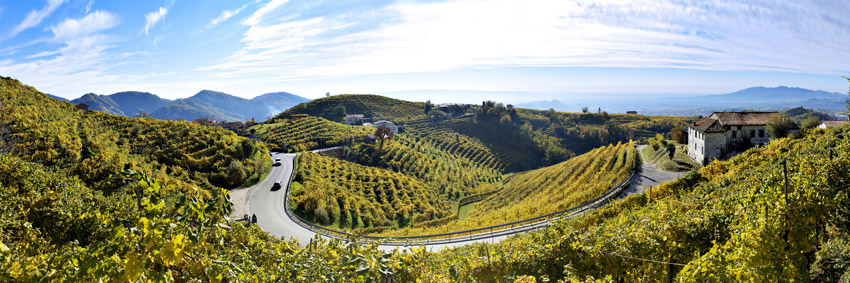
Gorges des Gâts (80-90km) – high valley with cliffs up to 400m high between Châtillon-en-Diois and Glandage with Ruisseau des Gas river. The road at times goest through a set of small tunels, galleries or is caved in those limestone cliffs. L'Arche des Gorges des Gats, Les Sucettes de Borne, tons of smaller or bigger waterfalls, ponds, cliffs and caves. Not as famous as Fedaia (!!IIii11oneone) but not that far away from it.
Saint-Baudille-et-Pipet (121km) – Château de Montmeilleur from XV c.
Mens (125km) - Halle de Mens, Fontaine de la Place de la Mairie, Église Notre-Dame de Mens. A large block of limestone whose upper part is flat, horizontal and without roughness, located above Mens, on the way to Chatel, is considered as a "sacrificial stone".
Accarias (128,5km) – Château d'Accarias – castle from XVII c. Used as a fortress guarding Col Accarias.
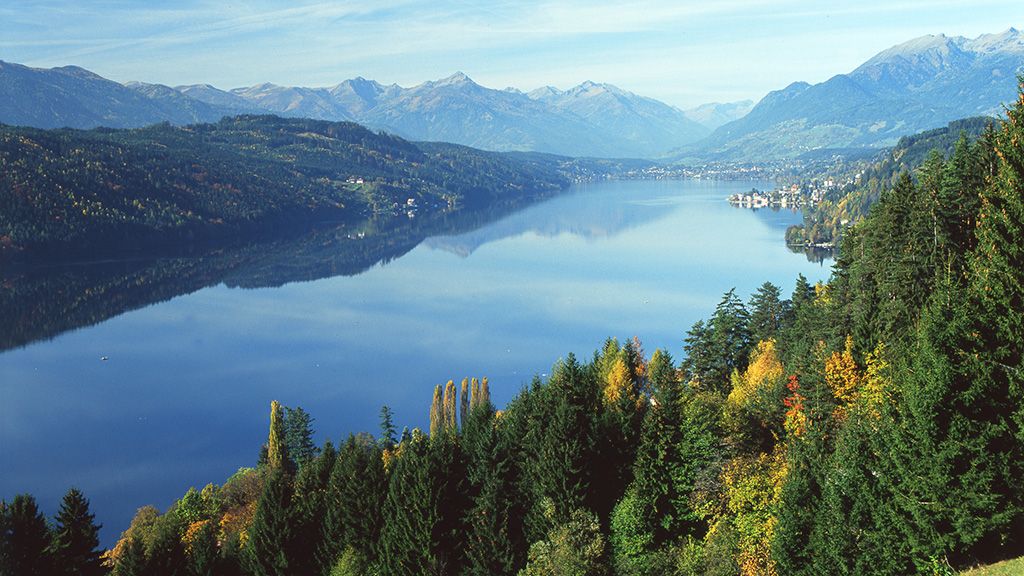
Notre-Dame de La Salette (finish) – some young sheperds on some good drugs in 1846 in a nearby La Salette-Fallavaux village claimed they've seen Virgin Mary and obviously a sanctuarium was created. This sanctuary looks gorgeous.