
Race Design Thread
Page 203 - Get up to date with the latest news, scores & standings from the Cycling News Community.
You are using an out of date browser. It may not display this or other websites correctly.
You should upgrade or use an alternative browser.
You should upgrade or use an alternative browser.
It's been a while since I posted a race over here, so to work myself back into a decent shape I'll start with something quite easy. I will take another approach to my beloved (design-wise) Tour de France.
I find the course of the 2016 TdF rather good, but it still has some major flaws. The two most obvious, in my opinion, are the lack of flat ITT kilometres and the lack of a real queen (or king) stage in the Alps, combined with the below par use of a fine climb like Montée de Bisanne.
So in my next posts I will try to set things straight. I will use the same start and finishlocations (not necessarily exactly the same spot, and not in necessarily in the same order).
Off we go....
The slightly modified 2016 Tour de France
Stage 1: Mont-Saint-Michel - Utah Beach Sainte-Marie-du-Mont: 188 km, flat
No changes. An easy start for me, and for the riders. Although crosswinds and bad weather on the Cotentin peninsula can play a major role.
Stage 2: Saint-Lô - Cherbourg-en-Cotentin: 217km, hilly
The original stage was rolling with a hilly final (a 4th category climb with 8km to go and finish on a 3km long 3rd category climb), I'll make it hilly with a flat final 3km. I wanted to get rid of the final climb because I think that will paralyze action from classic specialists.
I hope the many hills in the last 100 or so km, combined with likely crosswinds, will provide a decent amount of action. This stage now rather is a shortened Tour of Flanders without cobbles or a shortened AGR than a poor man's Fleche Wallonne.
Map & Profile:

Climbs:
Côte de Hauteville: km122; 800m @ 8%; 4th cat
Côte des Pieux: km129.5; 1.6km @ 7%; 3rd cat
Côte des Vantroux: km158; 1.3km @ 8.8%; 3rd cat
Côte des 13 Vents: km162; 1.2km @ 7.9%; 4th cat
Côte du Mesnil: km166; 1.6km @ 7%; 3rd cat
Côte des Guillemins de Ham; km172; 1.4km @ 6.6%; 4th cat
Côte de Hameau Fleury: km175; 1.2km @ 6.8%; 4th cat
Côte de Hameau ès Clerges: km180.5; 900m @ 6.1%; not categorised
Côte de Haut Hameau: km191; 1km @ 7.4%; 4th cat
Côte du Haut de Nacqueville: km195.5; 800m @ 9.5%; 4th cat
Côte d'Amféville: km198.5; 700m @ 8.6%; 4th cat
Côte du Hameau le Breton: km202; 1km @ 5.2%, nc
Côte du Fort du Tot: km207; 1km @ 5%, nc
Côte de Saint-Sauveur: km212; 1km @ 6%; 4th cat (this is the 4th cat climb with 8km to go in the original course)
For a while I thought about a total makeover for the Grand Départ. The first stage would then be Mont Saint-Michel - Cherbourg with the same final 100km as this one and the 2nd stage would be Saint-Lô - Utah beach, a flat ITT of about 43km. But that would neutralize the first stage too much, so I let that idea go.
Stage 3: Granville - Angers: 222km, flat
No changes
Stage 4: Saumur - Limoges: 232km, rolling
No changes. We don't have an exact profile of the final of this stage, but it can be quite tricky. In 1995 Pantani attacked the peloton in the final km's and gained 20 seconds. In 2007 a stage in Paris-Nice finished in Limoges with Pellizotti as winner and Purito in the top 5. The peloton fractured in the closing kilometres on that occasion and the first group only counted about 25 riders.
Stage 5: Limoges - Le Lioran: 217km, medium mountains
Some minor changes. I'm including the Col de Néronne before the Pas de Peyrol, skipping the long false flat run-in to the steep part of the latter. In the final I choose the Col de Cère instead of the Col de Font de Cère. The former is a bit shorter and steeper, and a bit closer to the finish. The Col the Font de Cère, however, is followed by a technical but not too steep downill and a final uphill stretch of about 500m @ 6%. My finish (which is actually the same as that of the real course) is located after a short descent (500m @ 6-7%).
Map & Profile:

Climbs:
Côte de Chassagne: km62; 1km @ 7.2%; 4th cat
Côte de la Croix de Pey: km75.5; 4.7km @ 5.8%; 3rd cat
Côte de Saint-Yrieix-le-Déjalat: km90.5; 3.5km @ 5.7%; 3rd cat
Côte de Soursac: km125; 4.2km @ 5.1%; 3rd cat
Côte de Chalvignac: km136; 2.6km @ 8%; 3rd cat
Col de Néronne: km176.5; 3.9km @ 8.9%; 2nd cat
Pas de Peyrol: km188; 5.4km @ 8.1%; 2nd cat
Col du Perthus: km204.5; 4.4km @ 7.9%; 2nd cat
Col de Cère: km214.5; 5.9km @ 4.8%; 3rd cat
Stage 6: Arpajon-sur-Cère - Montauban: 187km, rolling
No changes.
I find the course of the 2016 TdF rather good, but it still has some major flaws. The two most obvious, in my opinion, are the lack of flat ITT kilometres and the lack of a real queen (or king) stage in the Alps, combined with the below par use of a fine climb like Montée de Bisanne.
So in my next posts I will try to set things straight. I will use the same start and finishlocations (not necessarily exactly the same spot, and not in necessarily in the same order).
Off we go....
The slightly modified 2016 Tour de France
Stage 1: Mont-Saint-Michel - Utah Beach Sainte-Marie-du-Mont: 188 km, flat
No changes. An easy start for me, and for the riders. Although crosswinds and bad weather on the Cotentin peninsula can play a major role.
Stage 2: Saint-Lô - Cherbourg-en-Cotentin: 217km, hilly
The original stage was rolling with a hilly final (a 4th category climb with 8km to go and finish on a 3km long 3rd category climb), I'll make it hilly with a flat final 3km. I wanted to get rid of the final climb because I think that will paralyze action from classic specialists.
I hope the many hills in the last 100 or so km, combined with likely crosswinds, will provide a decent amount of action. This stage now rather is a shortened Tour of Flanders without cobbles or a shortened AGR than a poor man's Fleche Wallonne.
Map & Profile:
Climbs:
Côte de Hauteville: km122; 800m @ 8%; 4th cat
Côte des Pieux: km129.5; 1.6km @ 7%; 3rd cat
Côte des Vantroux: km158; 1.3km @ 8.8%; 3rd cat
Côte des 13 Vents: km162; 1.2km @ 7.9%; 4th cat
Côte du Mesnil: km166; 1.6km @ 7%; 3rd cat
Côte des Guillemins de Ham; km172; 1.4km @ 6.6%; 4th cat
Côte de Hameau Fleury: km175; 1.2km @ 6.8%; 4th cat
Côte de Hameau ès Clerges: km180.5; 900m @ 6.1%; not categorised
Côte de Haut Hameau: km191; 1km @ 7.4%; 4th cat
Côte du Haut de Nacqueville: km195.5; 800m @ 9.5%; 4th cat
Côte d'Amféville: km198.5; 700m @ 8.6%; 4th cat
Côte du Hameau le Breton: km202; 1km @ 5.2%, nc
Côte du Fort du Tot: km207; 1km @ 5%, nc
Côte de Saint-Sauveur: km212; 1km @ 6%; 4th cat (this is the 4th cat climb with 8km to go in the original course)
For a while I thought about a total makeover for the Grand Départ. The first stage would then be Mont Saint-Michel - Cherbourg with the same final 100km as this one and the 2nd stage would be Saint-Lô - Utah beach, a flat ITT of about 43km. But that would neutralize the first stage too much, so I let that idea go.
Stage 3: Granville - Angers: 222km, flat
No changes
Stage 4: Saumur - Limoges: 232km, rolling
No changes. We don't have an exact profile of the final of this stage, but it can be quite tricky. In 1995 Pantani attacked the peloton in the final km's and gained 20 seconds. In 2007 a stage in Paris-Nice finished in Limoges with Pellizotti as winner and Purito in the top 5. The peloton fractured in the closing kilometres on that occasion and the first group only counted about 25 riders.
Stage 5: Limoges - Le Lioran: 217km, medium mountains
Some minor changes. I'm including the Col de Néronne before the Pas de Peyrol, skipping the long false flat run-in to the steep part of the latter. In the final I choose the Col de Cère instead of the Col de Font de Cère. The former is a bit shorter and steeper, and a bit closer to the finish. The Col the Font de Cère, however, is followed by a technical but not too steep downill and a final uphill stretch of about 500m @ 6%. My finish (which is actually the same as that of the real course) is located after a short descent (500m @ 6-7%).
Map & Profile:
Climbs:
Côte de Chassagne: km62; 1km @ 7.2%; 4th cat
Côte de la Croix de Pey: km75.5; 4.7km @ 5.8%; 3rd cat
Côte de Saint-Yrieix-le-Déjalat: km90.5; 3.5km @ 5.7%; 3rd cat
Côte de Soursac: km125; 4.2km @ 5.1%; 3rd cat
Côte de Chalvignac: km136; 2.6km @ 8%; 3rd cat
Col de Néronne: km176.5; 3.9km @ 8.9%; 2nd cat
Pas de Peyrol: km188; 5.4km @ 8.1%; 2nd cat
Col du Perthus: km204.5; 4.4km @ 7.9%; 2nd cat
Col de Cère: km214.5; 5.9km @ 4.8%; 3rd cat
Stage 6: Arpajon-sur-Cère - Montauban: 187km, rolling
No changes.
- Feb 20, 2010
- 33,248
- 15,772
- 28,180
I'm going with something slightly out of the ordinary for me - a rouleur's 1.1 race.
Over the course of the thread I've done a few one-day races, Worlds circuits and the like, and I did a couple of one day races in tribute to deceased riders (Xavier Tondó and José María Jiménez, for those that didn't already know/hadn't read/hadn't already guessed). I'm now going to do a race in tribute to a guy who in fact has not died, but who is now for the most part lost to the annals of time in the sport, but whose country does play a role in the sport and in fact is organizing an increasing number of races.
The country is Estonia, and the rider is one of the most talented guys ever to come out of the Soviet Union and a personal favourite of mine from the Ostbloc days, the phenomenal engine that is Aavo Pikkuus. Aavo had an interesting career, emerging as a supertalent very young. He was born in November 1954 in the small village of Kapera, near Vastselinna in the southeastern Estonian province of Võrumaa, and raced for SC Dynamo Tartu regionally, the Estonian SSR supraregionally, and soon enough the USSR internationally. He was trained by Rein Kirsipuu, father of the now more famous Jaan. His breakthrough came as an 18-year-old when he was runner up in the Tour of the Baltic, a pseudo-precursor to the modern race through the Estonian, Latvian and Lithuanian SSRs over many kilometres of horrible dirt roads. At the time he was already the regional champion of Estonia, which he'd won the previous summer in a surprise escape. His prowess against the clock and in powering over the horrible road surfaces led to selections to race internationally the following year, capped with a podium at the Circuit de la Sarthe and an impressive introduction to the Peace Race - finishing 2nd in the opening ITT and leading for four days through Poland, before falling away, before a 3rd place in the queen stage to Ustí nad Labem pulled him up to 5th in the GC.
After turning 20, international wins started to follow. Winning the GP de l'Independence was followed by a 2nd in the mountainous Tour d'Algérie behind Sven-Åke Nilsson, the Swede who later went on to two Tour top 10s and a Vuelta podium. He upgraded his Friedensfahrt performance to 3rd, mostly keeping his powder dry but finishing 2nd in the long ITT, the only one of the race. He then won the Tour du Hainaut-Occident in Belgium, and the 1975 Tour de l'URSS (the 'Soviet National Championships in Stage Racing', a two week race in the autumn which moved locations year to year) to cement his reputation. In 1976 he backed down from stage racing to focus on the 100km four-man TTT, returning with a gold medal.
But 1977 was where his real glory lay. Opening the season with two stages of the Vuelta a Cuba, he easily won the Tour of Sochi, the most mountainous stage race in the Soviet calendar (until the Tour de l'URSS moved to the Crimea at least) and the Circuit de la Sarthe, leading to another Peace Race selection. The domination of the 1977 Friedensfahrt is one of the legends of Ostbloc cycling, to the extent that his French wikipedia page quotes Miroir du Cyclisme in its heading - "Aavo Pikkuus vainqueur à la Jacques Anquetil". And it's true - it's the kind of win that Monsieur Chrono would have been proud of. Klaus Ulrich Huhn, sports editor of Neues Deutschland and part of the organizing committee, described it as "eine sportlich fast langweilige Fahrt". Aavo won the opening ITT in Warsaw, gained time in a late move on stage 2 and with the help of loyal lieutenant Vladimir Osokin extended his lead further in stages 4 and 5; the two beat the field again in the ITT in Berlin, and then Pikkuus stuck three minutes on the field in the toughest mountain stage before letting Osokin do the same a day later to ensure the Soviet 1-2. The USSR won the team competition by ten minutes; Aavo won the Activity jersey, the mountains jersey, the Nachwuchs (youth) jersey and the combination jersey. It was pure domination, and despite Hartnick's 1976 triumph, Aavo's victory - and the manner of it - signalled that the era of the great Polish team of the 70s was over, and ushered in an era of Soviet domination in the biggest amateur races. At age 22, Pikkuus was the coming man.

Aavo in the leader's jersey of the Friedensfahrt in 1977, next to defending champion Hans-Joachim Hartnick
The following year, he was 15 seconds off the lead of the Friedensfahrt when teammate Aleksandr Averin got into a break which pressured the leaders. Refusing to chase down his teammate, the reigning champion gave up the defence in order to play the role of teammate (an important factor in those days, of course), falling to sixth in the course of putting his formidable engine to use as a domestique; Averin repaid the favour by helping Pikkuus to the victory in the more mountainous Tour of Yugoslavia. The Estonian also won the Giro delle Regioni for good measure. In 1979, we had an abnormally mountainous Course de la Paix, and with Sergey Sukhoruchenkov rushing to a huge lead in the first few days through the Slovakian mountains, Aavo was his strongest domestique, finishing 5th and winning the Combination classification. He podiumed his favourite western race, the Circuit de la Sarthe, once more, and won closer to home in the Saaremaa Velotuur, the biggest Estonian race at the time.

Becoming bored with life as a cyclist in the Communist world of no-professionals-allowed, however, Aavo returned to his first love, which was cars. As a child he had dreamed of the likes of Juan Manuel Fangio, and so it came to be. Late in 1981, just before his 27th birthday, Pikkuus asked not to be considered for international selection anymore - he was retiring from the bicycle, and becoming a rally driver. He wasn't a bad one either - finishing 4th in the USSR championship one year in fact, and after retiring he became a rally organizer along with running a sports company after the collapse of the USSR and the subsequent independence of his homeland.
There is a book about him, unfortunately as far as I can tell it has never been translated out of Estonian, which is a shame as I would love to read it; he's one of the most interesting characters and personalities of the Ostbloc days. Nowadays beset with health problems as he heads into his sixties, Aavo is still something of a cult hero in Estonia, cropping up from time to time. And what better way than to give him his own race, to help develop and discover the Aavo Pikkuuses of the future in the Baltic states?

GP Võru-GP Aavo Pikkuus, 184km


As you can see, I've placed the start and finish in Võru, since it will take place around Võrumaa. Tartu has its own GP already (partially subsumed into the Tour of Estonia) and this is closer to Aavo's hometown anyway. It serves as an attractive lakeside location, and the race can be placed on the calendar as close as possible to either the Baltic Chain Tour or the Tour of Estonia to benefit the field. As ever with Eastern European .HC and .1 races I don't expect much WT interest, though from ProConti CCC, ActiveJet and Gazprom-Rusvelo are a possibility. The bulk of the field would be Continental, with some Baltic States and Scandinavian teams complemented by some national squads made up of Continental-level riders and U23s being most likely. Maybe some German development teams and, given the nature of the race, Belgian cyclocross teams, could make the trip.

The main issue with the race is, as you will see from the profile, that I have "shaded" or rather "un-shaded" several sections of the route; that is because these sections are unpaved, unsealed sterrato or dirt roads. Of the 184km of racing, over 50 are on dirt roads, over five sectors (one is undertaken multiple times). Aavo himself was a monster rouleur capable of putting down some of the most formidable power the Ostbloc has ever seen over the rough surfaces, cobbles and Plattenwege of the Peace Race, plus also as a rally driver has had plenty of action on gravel, dirt and unsealed roads, so it only seems fitting that, given Estonia is hardly known for its hills, we make the race selective in another way that pays tribute to its namesake.

Sector 1: Plaani - Haanja
The first sector is the longest, over 10km in length from Plaani to the junction for the road between Rõuge and Haanja (Haanja is also a well-known cross-country skiing town in Estonia, though I didn't include it for that reason for once) but well over 100km from the finish. Even away from the gravel the roads aren't exactly special in terms of quality but we do get plenty of colourful, scenic countryside. There's a long trip over to Vastseliina with its ruined castle, which takes in our second sector, wide and dusty.

At this point we enter a circuit of 13,2km which we do five laps of. This tricky, rolling course has been selected because it passes around the hamlet of Kapera, where Aavo was born, and so there will be sprint primes in the tiny village each time they pass through. To add to the difficulty, there are 6,7km of the lap on sterrato, though for the most part it's wide enough and in decent enough condition that it shouldn't be any logistical problem.

Sector 3: Kapera - Kaagu via Kerepäälse
So yes, that's five times around a circuit where 6,7km is sterrato and 6,5km is narrow, rough tarmac. This should be enough to cause things to break apart and I wouldn't be surprised if some backmarkers have to be pulled from the circuit to be lapped here. The final time the riders take this sterrato, the sector finishes with 29km to the line so there's plenty of opportunity to make moves by then. When leaving the circuit, we turn right when we rejoin tarmac rather than left into Kaagu village, and head towards the town of Loosi. This allows a short respite for the riders before another 7,5km of sterrato begins, ending 17km from the line.

Sector 4: Loosi - Panometsa
After this it's just a mostly flat route on slightly better roads into Võru, broken up for a short uphill drag and then a brief (around 1km in length) stretch of dirt road at 7km from the line. The finish is on a nice open road in case it comes down to a sprint, although I'd expect small groups at most. Aavo Pikkuus was not about riding to the finish in a large bunch when he wanted to win, so I don't think people here should be.
Over the course of the thread I've done a few one-day races, Worlds circuits and the like, and I did a couple of one day races in tribute to deceased riders (Xavier Tondó and José María Jiménez, for those that didn't already know/hadn't read/hadn't already guessed). I'm now going to do a race in tribute to a guy who in fact has not died, but who is now for the most part lost to the annals of time in the sport, but whose country does play a role in the sport and in fact is organizing an increasing number of races.
The country is Estonia, and the rider is one of the most talented guys ever to come out of the Soviet Union and a personal favourite of mine from the Ostbloc days, the phenomenal engine that is Aavo Pikkuus. Aavo had an interesting career, emerging as a supertalent very young. He was born in November 1954 in the small village of Kapera, near Vastselinna in the southeastern Estonian province of Võrumaa, and raced for SC Dynamo Tartu regionally, the Estonian SSR supraregionally, and soon enough the USSR internationally. He was trained by Rein Kirsipuu, father of the now more famous Jaan. His breakthrough came as an 18-year-old when he was runner up in the Tour of the Baltic, a pseudo-precursor to the modern race through the Estonian, Latvian and Lithuanian SSRs over many kilometres of horrible dirt roads. At the time he was already the regional champion of Estonia, which he'd won the previous summer in a surprise escape. His prowess against the clock and in powering over the horrible road surfaces led to selections to race internationally the following year, capped with a podium at the Circuit de la Sarthe and an impressive introduction to the Peace Race - finishing 2nd in the opening ITT and leading for four days through Poland, before falling away, before a 3rd place in the queen stage to Ustí nad Labem pulled him up to 5th in the GC.
After turning 20, international wins started to follow. Winning the GP de l'Independence was followed by a 2nd in the mountainous Tour d'Algérie behind Sven-Åke Nilsson, the Swede who later went on to two Tour top 10s and a Vuelta podium. He upgraded his Friedensfahrt performance to 3rd, mostly keeping his powder dry but finishing 2nd in the long ITT, the only one of the race. He then won the Tour du Hainaut-Occident in Belgium, and the 1975 Tour de l'URSS (the 'Soviet National Championships in Stage Racing', a two week race in the autumn which moved locations year to year) to cement his reputation. In 1976 he backed down from stage racing to focus on the 100km four-man TTT, returning with a gold medal.
But 1977 was where his real glory lay. Opening the season with two stages of the Vuelta a Cuba, he easily won the Tour of Sochi, the most mountainous stage race in the Soviet calendar (until the Tour de l'URSS moved to the Crimea at least) and the Circuit de la Sarthe, leading to another Peace Race selection. The domination of the 1977 Friedensfahrt is one of the legends of Ostbloc cycling, to the extent that his French wikipedia page quotes Miroir du Cyclisme in its heading - "Aavo Pikkuus vainqueur à la Jacques Anquetil". And it's true - it's the kind of win that Monsieur Chrono would have been proud of. Klaus Ulrich Huhn, sports editor of Neues Deutschland and part of the organizing committee, described it as "eine sportlich fast langweilige Fahrt". Aavo won the opening ITT in Warsaw, gained time in a late move on stage 2 and with the help of loyal lieutenant Vladimir Osokin extended his lead further in stages 4 and 5; the two beat the field again in the ITT in Berlin, and then Pikkuus stuck three minutes on the field in the toughest mountain stage before letting Osokin do the same a day later to ensure the Soviet 1-2. The USSR won the team competition by ten minutes; Aavo won the Activity jersey, the mountains jersey, the Nachwuchs (youth) jersey and the combination jersey. It was pure domination, and despite Hartnick's 1976 triumph, Aavo's victory - and the manner of it - signalled that the era of the great Polish team of the 70s was over, and ushered in an era of Soviet domination in the biggest amateur races. At age 22, Pikkuus was the coming man.
Aavo in the leader's jersey of the Friedensfahrt in 1977, next to defending champion Hans-Joachim Hartnick
The following year, he was 15 seconds off the lead of the Friedensfahrt when teammate Aleksandr Averin got into a break which pressured the leaders. Refusing to chase down his teammate, the reigning champion gave up the defence in order to play the role of teammate (an important factor in those days, of course), falling to sixth in the course of putting his formidable engine to use as a domestique; Averin repaid the favour by helping Pikkuus to the victory in the more mountainous Tour of Yugoslavia. The Estonian also won the Giro delle Regioni for good measure. In 1979, we had an abnormally mountainous Course de la Paix, and with Sergey Sukhoruchenkov rushing to a huge lead in the first few days through the Slovakian mountains, Aavo was his strongest domestique, finishing 5th and winning the Combination classification. He podiumed his favourite western race, the Circuit de la Sarthe, once more, and won closer to home in the Saaremaa Velotuur, the biggest Estonian race at the time.
Becoming bored with life as a cyclist in the Communist world of no-professionals-allowed, however, Aavo returned to his first love, which was cars. As a child he had dreamed of the likes of Juan Manuel Fangio, and so it came to be. Late in 1981, just before his 27th birthday, Pikkuus asked not to be considered for international selection anymore - he was retiring from the bicycle, and becoming a rally driver. He wasn't a bad one either - finishing 4th in the USSR championship one year in fact, and after retiring he became a rally organizer along with running a sports company after the collapse of the USSR and the subsequent independence of his homeland.
There is a book about him, unfortunately as far as I can tell it has never been translated out of Estonian, which is a shame as I would love to read it; he's one of the most interesting characters and personalities of the Ostbloc days. Nowadays beset with health problems as he heads into his sixties, Aavo is still something of a cult hero in Estonia, cropping up from time to time. And what better way than to give him his own race, to help develop and discover the Aavo Pikkuuses of the future in the Baltic states?
GP Võru-GP Aavo Pikkuus, 184km
As you can see, I've placed the start and finish in Võru, since it will take place around Võrumaa. Tartu has its own GP already (partially subsumed into the Tour of Estonia) and this is closer to Aavo's hometown anyway. It serves as an attractive lakeside location, and the race can be placed on the calendar as close as possible to either the Baltic Chain Tour or the Tour of Estonia to benefit the field. As ever with Eastern European .HC and .1 races I don't expect much WT interest, though from ProConti CCC, ActiveJet and Gazprom-Rusvelo are a possibility. The bulk of the field would be Continental, with some Baltic States and Scandinavian teams complemented by some national squads made up of Continental-level riders and U23s being most likely. Maybe some German development teams and, given the nature of the race, Belgian cyclocross teams, could make the trip.
The main issue with the race is, as you will see from the profile, that I have "shaded" or rather "un-shaded" several sections of the route; that is because these sections are unpaved, unsealed sterrato or dirt roads. Of the 184km of racing, over 50 are on dirt roads, over five sectors (one is undertaken multiple times). Aavo himself was a monster rouleur capable of putting down some of the most formidable power the Ostbloc has ever seen over the rough surfaces, cobbles and Plattenwege of the Peace Race, plus also as a rally driver has had plenty of action on gravel, dirt and unsealed roads, so it only seems fitting that, given Estonia is hardly known for its hills, we make the race selective in another way that pays tribute to its namesake.
Sector 1: Plaani - Haanja
The first sector is the longest, over 10km in length from Plaani to the junction for the road between Rõuge and Haanja (Haanja is also a well-known cross-country skiing town in Estonia, though I didn't include it for that reason for once) but well over 100km from the finish. Even away from the gravel the roads aren't exactly special in terms of quality but we do get plenty of colourful, scenic countryside. There's a long trip over to Vastseliina with its ruined castle, which takes in our second sector, wide and dusty.
At this point we enter a circuit of 13,2km which we do five laps of. This tricky, rolling course has been selected because it passes around the hamlet of Kapera, where Aavo was born, and so there will be sprint primes in the tiny village each time they pass through. To add to the difficulty, there are 6,7km of the lap on sterrato, though for the most part it's wide enough and in decent enough condition that it shouldn't be any logistical problem.
Sector 3: Kapera - Kaagu via Kerepäälse
So yes, that's five times around a circuit where 6,7km is sterrato and 6,5km is narrow, rough tarmac. This should be enough to cause things to break apart and I wouldn't be surprised if some backmarkers have to be pulled from the circuit to be lapped here. The final time the riders take this sterrato, the sector finishes with 29km to the line so there's plenty of opportunity to make moves by then. When leaving the circuit, we turn right when we rejoin tarmac rather than left into Kaagu village, and head towards the town of Loosi. This allows a short respite for the riders before another 7,5km of sterrato begins, ending 17km from the line.
Sector 4: Loosi - Panometsa
After this it's just a mostly flat route on slightly better roads into Võru, broken up for a short uphill drag and then a brief (around 1km in length) stretch of dirt road at 7km from the line. The finish is on a nice open road in case it comes down to a sprint, although I'd expect small groups at most. Aavo Pikkuus was not about riding to the finish in a large bunch when he wanted to win, so I don't think people here should be.
- Jun 30, 2014
- 7,060
- 2
- 0
Stage 7: Brixlegg - Imst; 141km


After the hardest stage of my Österreich Rundfahrt we have a pretty short road stage.
The stage starts in Brixlegg, the hometown of the former alpine skiing star Stephan Eberharter, aka the guy who dominated the speed races after the Herminator's near-fatal motorcycle accident.

The first 21km are false flat, then the Mairbach climb starts, 3.3km at 8.6% with a few sections at 13%. On top of the climb we have 5km of false flat, then a pretty easy highspeed descent will bring the riders down to Hall in Tirol, a town know for it's rather odd looking coat of arms.

Then we have one of the climbs that you can find around Innsbruck, Lans, 4.9km at 5.3%.
After the descent the riders will ride trough Innsbruck, the next 24km are false flat.
The next climb starts in Zirl, it's the Seefelder Sattel, 9.8km at 6% with 2km at 12% and a max. gradient of 18%, followed by 14km that are mostly false flat/slightly rolling.
It's this climb until Seefeld (after Seefeld you have an even longer section of false flat):
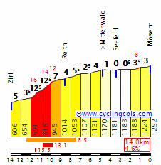
The following descent to Telfs is rather steep ( about7km at 8.5% before the false flat starts).
Before the final climb of the stage we have 12km of false flat, then Holzleitensattel starts, 11km at 4.4% with a few short 11% steep ramps near the top of the climb.
It's not a very spectacular climb, but it's still pretty stunning:


After the descent we still have 12.5km of false flat before the riders will reach Imst, you should know Imst because in 1949 Hermann Gmeiner founded the first SOS Children's Village in the Sonnberg district of Imst. SOS Children's Villages is an independent, non-governmental international development organization which has been working to meet the needs and protect the interests and rights of children since 1949.Some of you will also know Imst because of it's Luge track, even it's not exactly one of my favourite sports.
Imst:

This one should go to the breakaway, I just can't think of too many teams that would bother to control this stage, maybe OGE would try to control it. A few of the climbs are also hard enough to drop most of the sprinters.
If you have a decent sprint and you're able to climb a little bit this is the stage to join the breakaway.
If you'd like to have a vueltaesque uphill finish you could have one in Hochimst, the climb is 2.1km at 12.2% with a max. gradient of 17%, someone like Purito would love it, but I didn't want to have an uphill finish and with stage 6 being so hard a wanted to have an easier stage before the hard final stage of my Österreich Rundfahrt.
After the hardest stage of my Österreich Rundfahrt we have a pretty short road stage.
The stage starts in Brixlegg, the hometown of the former alpine skiing star Stephan Eberharter, aka the guy who dominated the speed races after the Herminator's near-fatal motorcycle accident.
The first 21km are false flat, then the Mairbach climb starts, 3.3km at 8.6% with a few sections at 13%. On top of the climb we have 5km of false flat, then a pretty easy highspeed descent will bring the riders down to Hall in Tirol, a town know for it's rather odd looking coat of arms.
Then we have one of the climbs that you can find around Innsbruck, Lans, 4.9km at 5.3%.
After the descent the riders will ride trough Innsbruck, the next 24km are false flat.
The next climb starts in Zirl, it's the Seefelder Sattel, 9.8km at 6% with 2km at 12% and a max. gradient of 18%, followed by 14km that are mostly false flat/slightly rolling.
It's this climb until Seefeld (after Seefeld you have an even longer section of false flat):
The following descent to Telfs is rather steep ( about7km at 8.5% before the false flat starts).
Before the final climb of the stage we have 12km of false flat, then Holzleitensattel starts, 11km at 4.4% with a few short 11% steep ramps near the top of the climb.
It's not a very spectacular climb, but it's still pretty stunning:
After the descent we still have 12.5km of false flat before the riders will reach Imst, you should know Imst because in 1949 Hermann Gmeiner founded the first SOS Children's Village in the Sonnberg district of Imst. SOS Children's Villages is an independent, non-governmental international development organization which has been working to meet the needs and protect the interests and rights of children since 1949.Some of you will also know Imst because of it's Luge track, even it's not exactly one of my favourite sports.
Imst:
This one should go to the breakaway, I just can't think of too many teams that would bother to control this stage, maybe OGE would try to control it. A few of the climbs are also hard enough to drop most of the sprinters.
If you have a decent sprint and you're able to climb a little bit this is the stage to join the breakaway.
If you'd like to have a vueltaesque uphill finish you could have one in Hochimst, the climb is 2.1km at 12.2% with a max. gradient of 17%, someone like Purito would love it, but I didn't want to have an uphill finish and with stage 6 being so hard a wanted to have an easier stage before the hard final stage of my Österreich Rundfahrt.
The slightly modified 2016 Tour de France, part 2: the Pyrenees and beyond
I think the three individual Pyrenean stages are well designed, but they should be held in the reverse order.
The stage to Pau is a hard one, but I think the main favorites won't take full advantage of it, out of fear from the next stage to Andorra-Arcalis. The stage to Lac de Payolle would be a nice way to leave the mountains: a final chance to grab some time before the transitional stages, but as first of a triptych, it probably only will serve to stretch the legs a bit.
Sadly enough, there's no way to sort those stages in a way I would like and within the boundaries of modern cycling (i.e.: no 300km long stages). So, I guess I have to redesign it a bit to increase the likeliness of a "long" range attack.
Stage 7: l'Isle Jourdain - Lac de Payolle: 181km, high mountains
Changes: I included the Port de Balès and Peyresourde before the Col d'Aspin. That will at least sap the legs a bit, and I took a shortcut on the Aspin, resulting in a steeper climb.
Map & Profile:

Climbs:
Port de Balès: km 119.5; 19.1km @ 6.1%; HC
Col de Peyresourde: km144.5; 9.8km @ 7.6%; 1st cat
Col d'Aspin: km174.5; 10.7km @ 7.1%; 1st cat
Stage 8: Pau - Luchon: 183km, high mountains
Probably the best designed stage of the lot, so why change it?
Stage 9: Vielha - Andorra/Arcalis: 184km, high mountains + mtf
There are definitely better options around, but I like the fact that it isn't too hard, so it leaves some space for action on the previous day. But not enough, I'm afraid.
Stage 10: Escaldes-Engordany - Revel: 194km, hilly
This stage starts with the highest climb of the whole tour, but than it peters out. Probably something for the strong sprinters or a breakaway. In 1997 a similar stage was won by Laurent Desbiens from a small breakaway with the peloton at 18 seconds.
Stage 11: Carcassonne - Montpellier: 161km, flat
Here i will change the layout from the stage. Originally, it was designed to venture inland, on a rolling course. I will design it to be held mainly on coastal roads, with the punchy Mont Saint-Clair with 30km to go. Hopefully crosswinds and the climb in Sète can create some havoc.
Map & Profile:

Climb:
Mont Saint-Clair: km128; 1.2km @ 11.7%; 3rd cat
Stage 12: Montpellier - Mont Ventoux: 185km, flat + mtf
No matter what, a stage to the Mont Ventoux will always come down to the final ascent, so no need to change anything.
Stage 13: Bourg Saint-Andéol - Vallon Pont d'Arc: 62km, itt
To compensate for the more difficult mountain stages, I also designed a way longer and generally flatter itt. I'm still not fully convinced of that final uphill stretch, though.
Map & Profile:

Stage 14: Montélimar - Villard-les-Dombes/Parc des Oiseaux: 208km, flat
Obligatory stage in the Rhône valley. No changes.
I think the three individual Pyrenean stages are well designed, but they should be held in the reverse order.
The stage to Pau is a hard one, but I think the main favorites won't take full advantage of it, out of fear from the next stage to Andorra-Arcalis. The stage to Lac de Payolle would be a nice way to leave the mountains: a final chance to grab some time before the transitional stages, but as first of a triptych, it probably only will serve to stretch the legs a bit.
Sadly enough, there's no way to sort those stages in a way I would like and within the boundaries of modern cycling (i.e.: no 300km long stages). So, I guess I have to redesign it a bit to increase the likeliness of a "long" range attack.
Stage 7: l'Isle Jourdain - Lac de Payolle: 181km, high mountains
Changes: I included the Port de Balès and Peyresourde before the Col d'Aspin. That will at least sap the legs a bit, and I took a shortcut on the Aspin, resulting in a steeper climb.
Map & Profile:
Climbs:
Port de Balès: km 119.5; 19.1km @ 6.1%; HC
Col de Peyresourde: km144.5; 9.8km @ 7.6%; 1st cat
Col d'Aspin: km174.5; 10.7km @ 7.1%; 1st cat
Stage 8: Pau - Luchon: 183km, high mountains
Probably the best designed stage of the lot, so why change it?
Stage 9: Vielha - Andorra/Arcalis: 184km, high mountains + mtf
There are definitely better options around, but I like the fact that it isn't too hard, so it leaves some space for action on the previous day. But not enough, I'm afraid.
Stage 10: Escaldes-Engordany - Revel: 194km, hilly
This stage starts with the highest climb of the whole tour, but than it peters out. Probably something for the strong sprinters or a breakaway. In 1997 a similar stage was won by Laurent Desbiens from a small breakaway with the peloton at 18 seconds.
Stage 11: Carcassonne - Montpellier: 161km, flat
Here i will change the layout from the stage. Originally, it was designed to venture inland, on a rolling course. I will design it to be held mainly on coastal roads, with the punchy Mont Saint-Clair with 30km to go. Hopefully crosswinds and the climb in Sète can create some havoc.
Map & Profile:
Climb:
Mont Saint-Clair: km128; 1.2km @ 11.7%; 3rd cat
Stage 12: Montpellier - Mont Ventoux: 185km, flat + mtf
No matter what, a stage to the Mont Ventoux will always come down to the final ascent, so no need to change anything.
Stage 13: Bourg Saint-Andéol - Vallon Pont d'Arc: 62km, itt
To compensate for the more difficult mountain stages, I also designed a way longer and generally flatter itt. I'm still not fully convinced of that final uphill stretch, though.
Map & Profile:
Stage 14: Montélimar - Villard-les-Dombes/Parc des Oiseaux: 208km, flat
Obligatory stage in the Rhône valley. No changes.
@rghysens. It's worth to note that's much more technical course and it can turn out to be more problematic for some of the riders. Guy like Froome can have more problems with getting bigger advantage here over less TT suited GC threats while guys like Contador, Valverde, Nibali or Bardet, who knows their handling ABCs can lose less time than normaly expected.rghysens said:Stage 13: Bourg Saint-Andéol - Vallon Pont d'Arc: 62km, itt
To compensate for the more difficult mountain stages, I also designed a way longer and generally flatter itt. I'm still not fully convinced of that final uphill stretch, though.
Map & Profile:
@Libertine_Seguros. I don't even think i want to know, from where you have all this information about now obscure Aavo Pikkuus. If you wrote this stuff just like it's nothing then you may be thankfull that we (earthlings) still don't know how to steal somebody's mind. You can find tons of not bad looking sterrato in Baltic or Central-East Europe countries while in Poland and Czech Republic there are some amount of those old German concrete roads (Plattenweg, that's their name?). You obviously know some of them from your German Tour, Tour de Pologne and Peace Race. Maybe in the future i'll try something in Central/Eastern Europe with less known roads/regions.
Guess i'll try to end my Dauphine and today it seems i'll try my first ever public try at queen stages. I wonder how it will turn out. I tried to be as short as i can be while keeping most of the in my opinion important information.
Critérium du Dauphiné by railxmig - stage 7
Queen stage of the Dauphine and propably the last chance to take back any lost time and fight for the GC win. Last stage will be hilly with a flat/false-descend finish to Grenoble and it shouldn't be any challenge for GC riders.
Library: click here
Le Bourg-d'Oisans - Bourg-Saint-Maurice, 162km, ~4000m asc, Mountain


Start: Le Bourg-d'Oisans, Avenue de la République
Km 0: Le Bourg-d'Oisans, D1091, 3,7km from the start
Finish: Bourg-Saint-Maurice, Avenue de l'Arc en Ciel, ~130m sraight
Sprint: Saint-Étienne-de-Cuines, Avenue de la Gare, 800m straight
Feed zone: Bonneval, Villard-Benoit, D213
Start - km0:
Avenue de la République - Avenue de la Gare - D1091
List of climbs:
Col du Glandon - 21,7km, 5,1%, Hc Cat. 1924m
Col de la Madeleine - 19,2km, 8%, HC Cat. 2000m
Col du Tra - 9,8km, 7,9%, 1 Cat. 1310m
Montée de Valezan - 9km, 6,2%, 2 Cat. 1219m
Departaments:
Isère, start - 29,5km
Savoie, 44,5km - finish
Preface:
This stage is very classical with classic Glandon-Madeleine (imo never overused, Madeleine south is plain majestic) combo, but it's quite far from the finish line and classic start and finish locations (they're strategically placed and always content to host any race). The actual battle will be held on last, mostly unknown, two climbs in Val d'Isère - Col du Tra (or Notre-Dame-du-Pré, seems to be quite popular in stage design community) and Montée de Valezan (La Côte-d'Aime, D86). It's a multi-mountain stage with 4 climbs among which two of them are HC. In this Dauphine only three climbs are categorised as HC (only one proper – Madeleine) with Mont Revard on 2nd stage being the missing one here. It's theoretically the hardest stage of the whole race, but stage 2 does give it a run for it's money. It has similiar accumulation of estimated 4000m uphill.
This stage is actualy not that long, just over 160km but a hard stage before, 4 hard climbs today and the vision of it being last hard day should provide at least some sort of pace. MTF stage day before should weaken some legs creating more chances to get more time on someone than normaly expected. This stage can be divided into two parts.
First part – 0km – 120km. It's a high mountain part with two HC climbs almost back to back but proceeded by 15km of flat around Moûtiers.
Second part – 120km – 162km. A medium mountain part with a back to back cat. 1 and 2 climbs with a quite shallow downhill to Bourg-Saint-Maurice. This is where the whole race should be decided.
Purpose:
There were two MTFs and basically that's all there was for climbers. Now it's teoretically time for climbers that are either good descenders or just have good resistance. The design of this stage can tolerate any long range tries or strong brakaways. Basically it's the last and only chance for any bigger attacks to work. Because it's the last hard stage of the Dauphine and is after a hard stage with a MTF it can turn out to be deadly for riders with worser recouperation or who just didn't sleep well. Besides, the "MTF with descend finish next day" combination seems to be quite attractive for good racing and is somehow underused in real stage races. Now only hoping that any of those RFC (Random French Climber), Contadors or Nibalis didn't loose that much time to RSC (Random Sky Cyborg) and have enough strength, will and inteligence to properly test them out.
Start:
I don't think this place needs any explanation. Stage will start in Le Bourg-d'Oisans on Avenue de la République. Km 0 is located on D1091, 3,7km from the start. To reach km 0 peloton will follow:
Avenue de la République - Avenue de la Gare - D1091

I think ASO will be frustrated to not use their pet l'Alpe MTF. It's not a bad climb, but her location is a disaster with quite a lot of flat from either Galibier or Glandon. Ornon side is nicely linked but Ornon is sadly very easy and Col du Solude is way too far to be raceable.
Climbs:
This stage is the queen stage of this Dauphine so the climbs here will held crucial role with last two propably deciding the outcome of whole race. First two climbs are one of the best known in the world while next two ones are more traceur's stuff.
Col du Glandon (1924m). 21,7km at 5,1%. Nothing to add here as whole books were written about this col. I tackle the easiest south side that i generously categorised as HC. It technically should be a cat. 1 but otherwise I would have only one proper HC in the entire race, that's why i decided to be more generous here. It should prompt some of the riders chasing KOM points into a more populated breakaway.

Col de la Madeleine (2000m). 19,2km at 8%. Nothing to add here either. For a long time i was thinking about including the Montgellafrey side but decided agains it and i explain it later. I didn't lose anything as both those sides are similar in length and slope, but Montgellafrey side is more irregular, thus can be more difficult for some riders. Wonder if there is a realistic possibility (place) to have a finish in, or close to, Aigueblanche.

Col du Tra (1310m). First of the lesser known climbs located at the south edge of Val Tarentaise in west side of Vanoise Alpes at the base of Mont Jovet (2558m). It is a cat. 1 climb – 9,8km at 7,9%. It can be rounded up to 10km at 8%. It's quite regular with first 5kms being hardest at around 9% and max 12% while next 5kms are slightly easier towards the top with max 11%. It is a very technicall, interval ascent with 27 serpentines in 10kms (avg every 270m). It begins in Saint-Marcel, halfway between Moûtiers and Tunnel du Siaix on N90 road. At the top of this climb lies Notre-Dame-du-Pré village. This climb could be used in Dauphine in much older times but i doubt it. It seems however to be quite popular in race design community. The profile presented below has slightly different last 1-1,5km.

Because this climb is on a plateau (the road goes along the slope) so real descend starts after about 3,5km off the summit. Then it continues for another over 8km at around 6,5% before reaching Aime. The whole descend isn't very challenging and should be safe enough to be included in Dauphine widthout much problems.
I'm not sure about the name of this climb. I've seen it naming after the village on top. But I've seen i think two examples of refeering to this climb as Col du Tra. One of the heights close to the col is apparently named as Le Tra (1337m). I don't know the actual geography of this place and there's no sign at the top or before. For a long time i was divided between naming it after the village and adding Côte/Montée to the name, calling it as Col du Pré or Col du Tra. I decided to risk it and call it Col du Tra.
Montée de Valezan (1219m). Last climb of this stage located in Val Tarentaise at the foot of Mont Roignais (2995m) in southeast Beaufortain Alpes.

It's a cat. 2 climb with 9km at 6,2%. This climb is like an easier version of Col du Tra with first part being the hardest and then letting off towards the flattish summit on a plateau. First 6km are the most challenging ones at 7,3% with 2kms at over 8% while last 3kms on the top are relatively flat at 4%. The actual KOM is around 2km after Valezan village where the road crosses Nant des Combes creek. First, harder part of this ascent is quite technical with 11 serpentines in 5kms. Second part isn't difficult with no serpentines and only regular turns. I've managed to create an estimated profile of this ascent, I hope it is close enough to reality.

Because this climb tops at a plateau (similar case to Col du Tra) the summit and another around 4kms up to Montgirod are relatively flat. Next 5,5kms left to Bourg-Saint-Maurice is only slightly more downhill at roughly 6% so no one will have an easy time to rest. The whole descend isn't very challenging but has quite a lot of smaller, more or less profiled turns that can turn to be quite nasty for tired riders.
There are three sides of this climb: Aime side (climbed one), Bourg-Saint-Maurice side (descended one) and little known le Praz side (south side from N90 to Valezan). This side, up to Valezan village, is 5,5km at roughly 8%, so slightly harder than the Aime side but still cat. 2. I was for some time interested in this side but excluded it to not overuse N90 road, have better linking with climb before and because the road is very narrow (around one line wide) but interstingly asphalted. If it would be Giro or something smaller from RCS then i would seriously think about this side.

I've had similar problems with naming this climb as in Col du Tra example. This time I couldn't find much about this ascend or this road so I decided to go with universal naming and use the village's name near the top and add Côte/Montée. I've decided to include the latter one because i don't feel it could get just a Côte (Montée d'Hauteville). I don't know the exact criterias between using Côte/Montée prefixes.
Sprint:
Sprint will be held just after descend from Glandon, 60,2km into the race in Saint-Étienne-de-Cuines on Avenue de la Gare at the end of 800m straight line. It should be a breakaway contest and that group propably will be quite big. Besides, i don't think that sprinters will made to it, maybe somebody like Sagan could try but he will propably be in the breakaway.
Feed zone:
Feed zone is located on D213 in a small community of Villard-Benoit belonging to Bonneval village. It's placement is very interesting as it's on the bigger plateau on the Madeleine north ascent. This plateau is around 3-4km long and the feed zone starts just as this plateau begins.
Finish:
Like start, this obvious place doesn't need any explanation at all. Finish will be held in Bourg-Saint-Maurice, on Avenue de l'Arc en Ciel at the end of around 150m straight line. Unlike in 2009 Tour de France this time it will be approached from south.

Roads:
Rroads are mostly multi-quality as it likes to be in the mountains. From nice roads in the valleys culminating in N90 Alberville – Bourg-Saint-Maurice to an almost goat track on Col du Tra. Actually, this road up to Tra isn't that bad and most of the descend is actually on a nice road.
This stage begins on the famous Col du Lautaret D1091 Grenoble – Briançon road. Then turns into D526 Col du Glandon road. It was used in Tour and Dauphine sheepload of times. It's a nice two-lane road up and down. Then the stage heads into a place i like to call as "Decision".
This place is basically La Chambre A43 highway exit. I wouldn't have any problem with it but for some reason ASO fears it like some sort of venomous snake. If the Glandon-Madeleine combination was going to be crucial, then i would propably use this exit but because it isn't, then i decided to play it safe and go with ASO solution of going through D75E viaduct in La Girard. It does result in like 10km flat more, but it shouldn't change the outcome of this stage. Maybe closing this exit would be too costly, but ASO didn't have any problem with closing exits on the same autorute up to Saint-Jean-de-Maurienne.
After dealing with the "Decision" stage enters Col de la Madeleine's D213 road. It's the same road quality like Glandon one. For a long time i was concerned about Montgellafrey D76 side that is a lot more irregular but the road width and quality is quite dodgy (maybe slightly better than Col de Parquetout). I decided to not overstrain and just go with the regular side. If somebody and if money is willing then the Montgellafrey side can be used. I have nothing against it. Why I didn't liked Montgellafrey side will be explained in a minute...

After the descend stage enters Isère valley and turns south-east into Moûtiers on D990 road, parallel to N90 express road. Obviously the roads here are wide and dandy. After passing Moûtiers some problems arise. I didn't use Madeleine's Montgellafrey side because I will use N90 that doesn't seem to be used in actual Dauphine/Tour too much, so i'm not sure if i have any realistic access to this road. I just don't want to push the problems further, as Montgellafrey road is in pretty bad quality and I won't loose much. Madeleine isn't the core of this stage and the actual parameters will stay the same, only the actual ascent is more regular. Summarising, i've excluded Montgellafrey side to have a bigger propability in using N90 Albertville – Bourg-Saint-Maurice road. I will go with N90 (no longer express status) for around 4,5km up to Saint-Marcel-Les-Bermonts where the stage turns east into D88 where another climb starts.
D88 Notre-Dame-du-Pré isn't the worst road i've seen. Maybe it was even used in Dauphine in older times. It's not that narrow at mostly 1,5 lane width but the surface isn't in best of conditions. It's very twisty with 27 serpentines in 10kms. The road's maintenance seems to be fine, as harder turns are protected with barriers. First 3,5km of the descend is on a similar road with maybe slightly better surface quality but then, just after the bridge on Nant Thieret creek this road widens into a two-lane road with a seemingly very good surface. This first part of descend (or half-descend as we're on a plateau) isn't technical with only four turns and a couple of small bends that most of them can be cutted. This descend continues for another 8kms where the road is wide and good, but get's slightly more technicall with 8 sperentines to tackle and an obvious narrowing in Longefoy (km 3).
The stage then continues under N90 and enters Aime where it turns north-east into D86 Aime – Valezan – Bourg-Saint-Maurice road where basically rest of the stage continues. Up to Valezan (around 7,5km) the road is two-lane on a seemingly good surface but then at the top it turns into a similar road to the one up to Notre-Dame-du-Pré. It continues for next 4,3km to Montgirod where it turns back into a two-lane road with fine surface and that road continues to the finish line. The worser road is on a plateau and isn't technically difficult so it shouldn't provide any security problems. This whole descend is not difficult with only 5 wide turns and a couple of smaller ones.
Possible outcome:
There are a lot of those. Among them are: 10 GC-man sprint group with obvious Valverde or Mollema win, a GC threat beating favourites group by around 1:00 – 1:30, a breakaway win by a RFC who lost around 5min in GC somewhere before and many others. I will try to focus here more on the last 40kms.
40km before the finish there propably will be a quite big breakaway around 2min ahead of peloton. Knowing life, in this breakaway there will be some riders who won't contribute to the pace as they're from favourites group waiting to work as relay stations. Problem is, if and where the potential attacks can occur. Col du Tra is consistent and steep but it's quite far from the finish, the descend isn't the most challenging one with only 6 serpentines and it's proceeded by Montée de Valezan. While Montée de Valezan has steep first 6kms but last 3kms are flattish and it does continue after the actual KOM. Besides, downhill from Valezan is quite easy and shallow (mostly 5 to 6%) so it can hamper any long range tries. This descend seems to be more designed for bigger groups rather than individuals trying to take any time. It can be defective though, as resistance will be tested to it's maximum and an unorganised chase can lose a lot of time on those flattish secions.
Propably an actual try on Col du Tra will have bigger chances to be profitable than on Valezan. An attacker will need then to rely on relay stations and his climbing/TT skills rather than technical skills. Why do I feel like it could be a good terrain for a long-range Froome attack? Even if Froome rarely (i don't remember him, or just forgot, ever doing such thing) does such audatious moves (in Sky's book of truth). Darn, those Sky lads are quite effective in their job.
Possible variations:
No Val Thorens, Mottaret or Courchevel. I wasn't seeking for a MTF and those ascends are very popular and well used. I try to not copy anyone's stage and ending in any of aforementioned ski stations would obviously copy somebody's stage. Besides, it would be boring and repetitive.
Propable, unrealistic but harder variation can include Peisey-Nancroix – Les Arc 1800 climb (D226) but then downhill from Valezan climb not straight into Bourg-Saint-Maurice but to Bellentre turning just before Montgirod (D86B), or Col de la Chal (2457m) if you prefer mountain biking (col between Les Arc 2000 and Peisey-Nancroix).
If you're interested in a hilly/medium mountain stage to Bourg-Saint-Maurice then you can use Col du Tra (unless you're willing to go through Tunnel du Siaix on N90) and then just go through D220. It's a parallel road to N90 but goes on the other side of Isère. Most of this road, beside obvious narrowings in villages, is two-lane on a fine surface. Then, just before reaching Bourg-Saint-Maurice you can use a small and short road (D220E) through La Ravoire village. It's 2,1km long and it's wide enough (1,3 to 1,5 lane) to handle for ex. Dauphine. It's surface isn't in the best of shapes but not the worst i've seen. This hill would be 2,1km long at roughly 7% (948m a.s.l.), a fine cat. 3 hill quite close to the finish line (4,6km). Descend would be then on a D119 Les Arcs road.
Geography:
I don't think most of this stage's locations need any explanation at all as they're basically every year in ASO races. The last part of the stage after Moûtiers is in Val Tarentaise.
Val Tarentaise – Isère valley in the area from Moûtiers to Bourg-Saint-Maurice, between Vanoise and Beaufortain Alpes. Mostly known from tourist industry and winter sports as there are many ski stations that were present in '92 Albertville winter olympic games (Courchevel, Meribel-Mottaret, Les Menuires, Val Thorens, Les Arcs, La Plagne, Tignes and Val d'Isère). It has the largest concentration of ski areas in such small space in the world.
Massif de la Vanoise – mountain range belonging to French Alpes between Arc and Isère rivers and Col de la Madeleine. It's entirely located in Savoie. It's a typical high-alpine range with a lot of glaciers, lakes and rough, rocky peaks. It has however a quite complex geology as basement is crystalline with metamorphic rocks (granit, gneiss, schist) while the summits are covered with sedimentary rocks, shales or clay. Highest peak – la Grande Casse (3855m).

Tourist attractions:
Because most of the stage uses the terrain used almost every year i will constrain myself only to the Tarentaise valley.
Moûtiers (117km) – Cathédrale Saint-Pierre de Moûtiers – HQ of the now defunct Archdiocese of Moutiers-Tarentaise, Pont Saint-Pierre – bridge over Isère from 1785.

Longefoy (136km) – Chapelle de la Superga – a reproduction of that famous Superga one in Turin
Aime (144km) – Basilique Saint-Martin d'Aime from XI c. Tour de montmayeur – an ancient fortified house protecting an old ford and now bridge over isère. Église Saint-Sigismond – originally a parish church of Aime built on Saint-Sigismond hill. La Plagne ski station.


Valezan (151km) – Chapelle de la Notre-Dame de Lourdes

- Jun 30, 2014
- 7,060
- 2
- 0
That's an awesome queenstage railxmig, hats off to you!
I'll post the final stage of my Österreich Rundfahrt durning the evening.
I'll post the final stage of my Österreich Rundfahrt durning the evening.
- Jan 13, 2014
- 898
- 0
- 0
2017 Vuelta de Argentina - Jujuy

Elevation is the key word for the 2017 Vuelta de Argentina, in this oportunity held in the Jujuy high mountains region.
Stage 1 - El Cármen - Abra Santa Laura (17.1 km)
The first stage is a short TT passing by the south of dikes La Cienaga and Las Maderas, a beautiful narrow road with lots of curves and souranded by trees. The 1.6 @ 4.2% Abra Santa Laura is the lonely climb of the stage.


Stage 2 - San Salvador de Jujuy - Cuesta de Lipán ( 117.8 km)
After a small pass through Los Alisos dike, the stage will be heading north to the Cuesta de Barcena 10.2 km @ 4.9 before the big finale, Cuesta de Lipan. This climb is a monster, the 34.7 km are endless, the base height is at 2220 m (altitude sickness can occur at 2400 m) and the top is at 4170 m. The slopes average 5.6% of gradient, this is pure climbers territory.


Stage 3 - Humahuaca - La Quiaca (154.9 km)
Final stage is from the colourful valley of Humahuaca to the northernmost argentinian city of La Quiaca. The only climb is the 1 km @ 5.2 Chorrillos, but most important almost the full stage is above 3500 m through an arid desert road exposed to crosswinds. can the climbers mantain the difference of yesterday stage?


Elevation is the key word for the 2017 Vuelta de Argentina, in this oportunity held in the Jujuy high mountains region.
Stage 1 - El Cármen - Abra Santa Laura (17.1 km)
The first stage is a short TT passing by the south of dikes La Cienaga and Las Maderas, a beautiful narrow road with lots of curves and souranded by trees. The 1.6 @ 4.2% Abra Santa Laura is the lonely climb of the stage.
Stage 2 - San Salvador de Jujuy - Cuesta de Lipán ( 117.8 km)
After a small pass through Los Alisos dike, the stage will be heading north to the Cuesta de Barcena 10.2 km @ 4.9 before the big finale, Cuesta de Lipan. This climb is a monster, the 34.7 km are endless, the base height is at 2220 m (altitude sickness can occur at 2400 m) and the top is at 4170 m. The slopes average 5.6% of gradient, this is pure climbers territory.
Stage 3 - Humahuaca - La Quiaca (154.9 km)
Final stage is from the colourful valley of Humahuaca to the northernmost argentinian city of La Quiaca. The only climb is the 1 km @ 5.2 Chorrillos, but most important almost the full stage is above 3500 m through an arid desert road exposed to crosswinds. can the climbers mantain the difference of yesterday stage?
- Sep 28, 2014
- 3,639
- 1,608
- 16,680
As promised, there would be long gaps between posting stages.
Critérium du Dauphiné Stage 2 Aubenas - Saint Ètienne (185km) (Sun) (Medium Mountains)


Climbs:
Col de l'Escrinet 13.4km @ 4.4%
Col des Quatre-Vios 18k @ 2.3%
Saint-Agrève 14.5km @3.5%
Col du Grand-Bois 12.1km @ 5.2%
Sprints:
Saint Martin de Valamas @ 73.5
Annonay @ 135.9
We continue the Dauphiné, by starting in the town of Aubenasin the Ardeche again. From the very begining we start climbing. The riders leave the town and head uo the D104 and up the Col de l'Escrinet. After a very brief descent, the riders leave the road to Privas and head up the next climb of the day. This is the Col des Quatre-Vios. After a little more climbing, the riders will then decsend into the town of Saint Martin de Valamas. Followin this, the riders will then start climbing up to Saint-Agrève Again there is more climbing after the summit of the categorised climb, but once that has been done, the riders will then descend into a a valley, where the second prime is in Annonay. Some rolling terrain follows as the riders ride through the valley to the foot of the third cat Col du Grand-Bois. After this, a descend into the town of Saint Ètienne for the finish.
Aubenas:

Saint Ètienne:

Critérium du Dauphiné Stage 2 Aubenas - Saint Ètienne (185km) (Sun) (Medium Mountains)
Climbs:
Col de l'Escrinet 13.4km @ 4.4%
Col des Quatre-Vios 18k @ 2.3%
Saint-Agrève 14.5km @3.5%
Col du Grand-Bois 12.1km @ 5.2%
Sprints:
Saint Martin de Valamas @ 73.5
Annonay @ 135.9
We continue the Dauphiné, by starting in the town of Aubenasin the Ardeche again. From the very begining we start climbing. The riders leave the town and head uo the D104 and up the Col de l'Escrinet. After a very brief descent, the riders leave the road to Privas and head up the next climb of the day. This is the Col des Quatre-Vios. After a little more climbing, the riders will then decsend into the town of Saint Martin de Valamas. Followin this, the riders will then start climbing up to Saint-Agrève Again there is more climbing after the summit of the categorised climb, but once that has been done, the riders will then descend into a a valley, where the second prime is in Annonay. Some rolling terrain follows as the riders ride through the valley to the foot of the third cat Col du Grand-Bois. After this, a descend into the town of Saint Ètienne for the finish.
Aubenas:
Saint Ètienne:
- Feb 20, 2010
- 33,248
- 15,772
- 28,180
I do sometimes forget that not everybody is as fascinated by Ostbloc cycling as me, as I found when I picked what I thought was a tricky-but-not-impossible "Guess who?" rider in Joachim Halupczok... nevertheless, helpfully with the Friedensfahrt, I can devour German-language sources, while there's a decent amount of Francophone material too. I did a fair bit of research and palmarès compiling and at one point wanted to do a thread on "the A-Z of cycling in the Eastern Bloc" or "the top 100 riders of the Eastern Bloc" where I would draw attention not only to the riders from the Wende (Ugrumov, Abdoujaparov, Ludwig, Ampler) and earlier huge stars (Schur, Szurkowski, Sukhoruchenkov) but some of the more obscure names who carved out strong niches and maybe even some of the trailblazers in western pro competitions and GTs (Lech Piasecki, Ivan Ivanov, Primož Čerin), but the amount of work that it would be compared to the number of people who'd likely care meant I rather lost interest a bit. Aavo is one of the big underrated names of the era though, because he was around and successful for enough years to say that he wasn't a one-hit wonder with a brief heyday like a Yuri Barinov (though what a hit it was!), but his early retirement meant he never compiled the breadth of palmarès that some athletes who kept competing well into their 30s did, like Jiří Škoda or Bernd Drogan.railxmig said:@Libertine_Seguros. I don't even think i want to know, from where you have all this information about now obscure Aavo Pikkuus. If you wrote this stuff just like it's nothing then you may be thankfull that we (earthlings) still don't know how to steal somebody's mind. You can find tons of not bad looking sterrato in Baltic or Central-East Europe countries while in Poland and Czech Republic there are some amount of those old German concrete roads (Plattenweg, that's their name?). You obviously know some of them from your German Tour, Tour de Pologne and Peace Race. Maybe in the future i'll try something in Central/Eastern Europe with less known roads/regions.
- Jun 30, 2014
- 7,060
- 2
- 0
Stage 8: Imst - Dornbirn; 182km


This is the final stage of my Österreich Rundfahrt and it will be the last chance to attack, it's a hard stage that could create decent gaps if it is raced hard enough.
The stage starts in Imst, so we don't have a transfer after stage 7, but right after the start of the stage we already have the only HC climb of the day, Hahntennjoch from Imst, 14.2km at 7.4% with a max. gradient of 14% multiple over 10% steep ramps and 2km at 11% in the middle of the climb.
It's this climb from Imst onwards:

It's also a pretty stunnig climb:


After the descent we have about 25km of false flat before we reach Steeg, a municipality that lies on the border to the state of Vorarlberg, then the next climb, Flexenpass, starts.


It's a rather easy climb, but the next climbs will be harder.
The following descent features a few hairpins, then we have about 30km of false flat before the next climb starts.
Then the next hard climb starts. It's the Thüringerberg-Faschinajoch combination, all in all 20.6km at 4.6%, but those numbers don't tell the whole story, there's a decent and false flat between those 2 climbs, Thüringerberg features a km at 12%, while Faschinajoch has 2km at 11%.


The following descent features a few steeper parts, but it's not a very technical descent, so the riders could reach pretty high speeds.
The next 18km are false flat, the riders will ride through the Bregenzerwald, one of the main regions in the state of Vorarlberg.
The final climb of the day is the eastern side of Bödele, 7.3km at 7.3% with multiple 10% steep ramps.


The final descent of the race is about 8.3km log and rather steep, only the final km is false flat.
The stage finishes in Dornbirn, the largest city in Vorarlberg and the tenth largest in Austria. Dornbirn only became such an important town at the end of the 19th century when it became a major centre of the textile industry.
Dornbirn:


This one should be interesting, with such a hard climb at the start of the stage we could get a very strong breakaway and the fight to get in the breakaway could make the first ascent of the day pretty fast, not everyone will like that.
If the race leader has a weak team the other teams will try to send their riders in the breakaway and we already could see attacks on the Faschinajoch, their teammates in the breakaway could support them on the false flat between Faschinajoch and Bödele and we could get big gaps.
If one team has more than one rider in the overall top 10 we even could get a situation like in 2012, when RadioShack send Birdsong in the Breakaway to help Rohregger, but the race leader Di Luca refused to chase and so Birdsong got a big lead an was able to win the stage and the whole Österreich Rundfahrt.
This is the end of my 3rd Österreich Rundfahrt, I hope you enjoyed it!
This is the final stage of my Österreich Rundfahrt and it will be the last chance to attack, it's a hard stage that could create decent gaps if it is raced hard enough.
The stage starts in Imst, so we don't have a transfer after stage 7, but right after the start of the stage we already have the only HC climb of the day, Hahntennjoch from Imst, 14.2km at 7.4% with a max. gradient of 14% multiple over 10% steep ramps and 2km at 11% in the middle of the climb.
It's this climb from Imst onwards:
It's also a pretty stunnig climb:
After the descent we have about 25km of false flat before we reach Steeg, a municipality that lies on the border to the state of Vorarlberg, then the next climb, Flexenpass, starts.
It's a rather easy climb, but the next climbs will be harder.
The following descent features a few hairpins, then we have about 30km of false flat before the next climb starts.
Then the next hard climb starts. It's the Thüringerberg-Faschinajoch combination, all in all 20.6km at 4.6%, but those numbers don't tell the whole story, there's a decent and false flat between those 2 climbs, Thüringerberg features a km at 12%, while Faschinajoch has 2km at 11%.
The following descent features a few steeper parts, but it's not a very technical descent, so the riders could reach pretty high speeds.
The next 18km are false flat, the riders will ride through the Bregenzerwald, one of the main regions in the state of Vorarlberg.
The final climb of the day is the eastern side of Bödele, 7.3km at 7.3% with multiple 10% steep ramps.
The final descent of the race is about 8.3km log and rather steep, only the final km is false flat.
The stage finishes in Dornbirn, the largest city in Vorarlberg and the tenth largest in Austria. Dornbirn only became such an important town at the end of the 19th century when it became a major centre of the textile industry.
Dornbirn:
This one should be interesting, with such a hard climb at the start of the stage we could get a very strong breakaway and the fight to get in the breakaway could make the first ascent of the day pretty fast, not everyone will like that.
If the race leader has a weak team the other teams will try to send their riders in the breakaway and we already could see attacks on the Faschinajoch, their teammates in the breakaway could support them on the false flat between Faschinajoch and Bödele and we could get big gaps.
If one team has more than one rider in the overall top 10 we even could get a situation like in 2012, when RadioShack send Birdsong in the Breakaway to help Rohregger, but the race leader Di Luca refused to chase and so Birdsong got a big lead an was able to win the stage and the whole Österreich Rundfahrt.
This is the end of my 3rd Österreich Rundfahrt, I hope you enjoyed it!
I barely know any word in French or German so i can only operate on translators. From the names you mentioned i recognize besides obvious picks "from the Wende" (whatever that means) hmm...Libertine Seguros said:I do sometimes forget that not everybody is as fascinated by Ostbloc cycling as me, as I found when I picked what I thought was a tricky-but-not-impossible "Guess who?" rider in Joachim Halupczok... nevertheless, helpfully with the Friedensfahrt, I can devour German-language sources, while there's a decent amount of Francophone material too. I did a fair bit of research and palmarès compiling and at one point wanted to do a thread on "the A-Z of cycling in the Eastern Bloc" or "the top 100 riders of the Eastern Bloc" where I would draw attention not only to the riders from the Wende (Ugrumov, Abdoujaparov, Ludwig, Ampler) and earlier huge stars (Schur, Szurkowski, Sukhoruchenkov) but some of the more obscure names who carved out strong niches and maybe even some of the trailblazers in western pro competitions and GTs (Lech Piasecki, Ivan Ivanov, Primož Čerin), but the amount of work that it would be compared to the number of people who'd likely care meant I rather lost interest a bit. Aavo is one of the big underrated names of the era though, because he was around and successful for enough years to say that he wasn't a one-hit wonder with a brief heyday like a Yuri Barinov (though what a hit it was!), but his early retirement meant he never compiled the breadth of palmarès that some athletes who kept competing well into their 30s did, like Jiří Škoda or Bernd Drogan.railxmig said:@Libertine_Seguros. I don't even think i want to know, from where you have all this information about now obscure Aavo Pikkuus. If you wrote this stuff just like it's nothing then you may be thankfull that we (earthlings) still don't know how to steal somebody's mind. You can find tons of not bad looking sterrato in Baltic or Central-East Europe countries while in Poland and Czech Republic there are some amount of those old German concrete roads (Plattenweg, that's their name?). You obviously know some of them from your German Tour, Tour de Pologne and Peace Race. Maybe in the future i'll try something in Central/Eastern Europe with less known roads/regions.
Szurkowski is propably one of the most famous Polish cyclists in history, back when they had one of the best TTT squad in the world. Wasn't he like 2nd in Paris-Nice once only behind Merckx in '73 or '74? When Paris-Nice was open for amateur cyclists.
Sukhoruchenkov. He smashed the olympic race in Moscow '80 if i remember correctly? Supposedly a great climber, wonder how he would fare in western races, but there's no or too small amount of information to even begin any estimation process.
From others i think i can only recognize Piasecki, who i think had some success in Italy in 80-ties with Lang?
I really like this map. It's refreshing and quite professional. Thumbs up.Guybrush said:2017 Vuelta de Argentina - Jujuy
I think there are like a bunch of such climbs in South America. This one is quite regular, but the length of it can provide some selection. Hoping only, that it won't be another Sierra Nevada that last time ended basically in a 30-man sprint (it was in 2010 or 2011), but i think the fact of it being basically the race decider should provide good racing and at least some gaps.Guybrush said:Stage 2 - San Salvador de Jujuy - Cuesta de Lipán ( 117.8 km)
After a small pass through Los Alisos dike, the stage will be heading north to the Cuesta de Barcena 10.2 km @ 4.9 before the big finale, Cuesta de Lipan. This climb is a monster, the 34.7 km are endless, the base height is at 2220 m (altitude sickness can occur at 2400 m) and the top is at 4170 m. The slopes average 5.6% of gradient, this is pure climbers territory.
This stage wasn't that awesome. The design can be dodgy, but i realised about them when i had the whole race ready to post. It doesn't really look like it looks on the first sight. I wrote about most of those problems in the stage's post, but i'll try to recap it here.Mayomaniac said:That's an awesome queenstage railxmig, hats off to you!
I'll post the final stage of my Österreich Rundfahrt durning the evening.
Biggest problem is those descends from last two climbs. They're not that difficult or technical and are mostly shallow (6 to 7% max). On the top of those climbs there are quite longish flat/false-flat sections. It is more a test of resistance rather than climbing, downhill and handling exploit. Those French quadruplets - Pinot, Bardet, Barguil and Roland, even if most of the time eager to attack from far away, will propably struggle on this course as they're rely on their more explosive nature and fine technical skills rather than maintaing a good overall tempo. They will need to rely on your teammate(s) that should be with them on those flattish and downhill/false-downhill sections. I think this stage would be curiously good for somebody like Froome, who can maintain a good tempo for a long time, if he'd lose some time and would not be Sky's pet cyborg.
I'll try to end my Dauphine tomorrow with a last stage and a small recap. It should give @lemon_cheese_cake full space for his Dauphine. I hope that my race doesn't interfere too much with your race.
After some busy weeks i will try to finish my TdF.
Tour de France
Stage 17: Lourdes - Errozate (185.9km)


After the rest day, we have the last MTF of the race abd maybe the last chance for pure climbers to gain or recover precious time before the last ITT. This stage can also be the one to finish all the doubts in relation to the GC winner.
The day starts in the city of Lourdes, known worlwide due to religious reasons and the temple in devotion to the virgin Mary.

The first kms of race are easy with some flat terrain before the first climb of the day. After 15km the riders will have climb the Aubisque from Soulour a HC climb that will make great damage in the main group and can be a good climb to some collective moves in order to destroy the leader block.

After Aubisque there is a long descent, where some riders can regain position in the main group, however in the final of the descent is another climb and a hard one. The 2nd ascent of the day is the Col de Marie Blanque a cat1 (10.8km@5.5) from Bielle. Its not the hardest side of the climb but it will not be easy to a tired group after 16 stages and Aubisque

After Marie Blanque is the easiest part of the stage, which presents a +/- long period of flat where the riders can recover some energies for the final part of the stage and for the final attacks. The last 75km will be decisive with 5 climbs close to each other, the first is the Pas de Lamayo, a HC climb in the roads of La Pierre Saint Martin. The ascent is the same of Pas de Guillers but include a final ramp to the Pas de Lamayo

After a brutal climb there is a long descent, that will bring the riders to the final combo of mountains. Starting in Larrau a 2.4km wall that marks the kick off to the nasty col de Bagargui

The previous climb is ideal to a medium range attacks, since the descent is short and until the final there are more difficulties, with the cat.4 of col de Surzay. After that ascent is the last climb of the day Errozate from south wich has some walls with 17% and where will be discussed the stage and maybe the race winner

P.S: There was an error with Cronoescalada and the last climb isn't a cat.3 for sure
Tour de France
Stage 17: Lourdes - Errozate (185.9km)
After the rest day, we have the last MTF of the race abd maybe the last chance for pure climbers to gain or recover precious time before the last ITT. This stage can also be the one to finish all the doubts in relation to the GC winner.
The day starts in the city of Lourdes, known worlwide due to religious reasons and the temple in devotion to the virgin Mary.
The first kms of race are easy with some flat terrain before the first climb of the day. After 15km the riders will have climb the Aubisque from Soulour a HC climb that will make great damage in the main group and can be a good climb to some collective moves in order to destroy the leader block.
After Aubisque there is a long descent, where some riders can regain position in the main group, however in the final of the descent is another climb and a hard one. The 2nd ascent of the day is the Col de Marie Blanque a cat1 (10.8km@5.5) from Bielle. Its not the hardest side of the climb but it will not be easy to a tired group after 16 stages and Aubisque
After Marie Blanque is the easiest part of the stage, which presents a +/- long period of flat where the riders can recover some energies for the final part of the stage and for the final attacks. The last 75km will be decisive with 5 climbs close to each other, the first is the Pas de Lamayo, a HC climb in the roads of La Pierre Saint Martin. The ascent is the same of Pas de Guillers but include a final ramp to the Pas de Lamayo
After a brutal climb there is a long descent, that will bring the riders to the final combo of mountains. Starting in Larrau a 2.4km wall that marks the kick off to the nasty col de Bagargui
The previous climb is ideal to a medium range attacks, since the descent is short and until the final there are more difficulties, with the cat.4 of col de Surzay. After that ascent is the last climb of the day Errozate from south wich has some walls with 17% and where will be discussed the stage and maybe the race winner
P.S: There was an error with Cronoescalada and the last climb isn't a cat.3 for sure
- Jun 16, 2015
- 1,948
- 527
- 12,080
Here we go again. Time to continue race designing where I left off under the nickname of Lupetto, just before the relaunch of the forum.
Clásica das Estevas
Fortaleza de Sagres › Cabo de São Vicente (236k)
Oh yes, it is a one day race and it is a one day race in Portugal. Or like the Kaiser once said: "We call it a Klassiker". So to say this is a rare occasion to get into one day racing in Portugal. Libertine wrote a lot about the history of one day racing in Portugal, so there isn't much to add. Besides the fact, that it's gone.")
I decided to locate my race in the south-western part of the country. This small coastal slice of land is known as "Parque Natural do Sudoeste Alentejano e Costa Vicentina" and it is a mecca for Surfers. And given the fact that there a like hundreds of praias, I thought about combining the beaches with the cycling race and my love for dirt roads. In this case riders will face around 30 kilometers of dirt roads around the beaches.
But first things first: What is an Esteva?

Well...these things are also known as rock rose and they grow above the beaches everywhere in Algarve. So riders will ride across thousands of these little plants and they will no doubt smell their very distinctive aromatic scent. So if this race goes done in April, Daniel Martin should better stay at home. The other option would be September or even Ocotber. Well the two dirt road downhills also exclude Dan Martin, but that's another story.

Climbs
1 Alto da Fóia 9,1 km @ 5,3% (km 92)
2 Vale d'Água de Cima 3,4 km @ 4,7% (km 110)
3 Alto da Ribeira de Seixe 1,4 km @ 8,4% (km 138)
4 Alto do Castelo de Aljezur 1,8 km @ 6,8% (km 165)
5 Alto da Praia do Canal 3,5 km @ 4,7% (km 185)
As some of you guys might know from Volta ao Algarve, that my start point Fortaleza de Sagres is only about three kilometers away from the finish at Cabo de São Vicente, the southwesternmost point in Portugal. Actually it is tourist spot and it can be a bit crowded, but especially in the evening hours just before the sundowner it is really spectacular.
Fortaleza da Sagres

So the race will take place between these monuments of former Portuguese naval history. The first 70 kilometers along the southern coast of the Algarve through the well known cities of Lagos and Portimão are really flat and since I don't expect much wind, this will be just a stretch to get the legs warm.
After leaving the coast and heading north, the pelotão will reach Monchique and from there they have to climb the first and biggest obstacle of the day. Alto da Fóia is the highest point of the Algarve and will be ridden as a mountain top finish in this year's Volta ao Algarve. I decided to go for the not so common approach from the north via M501. The last part of the climb is about 5,5 kilometers long and features 9% to 13% from kilometer 2,5 to kilometer 4. So if somebody decides to spice things up, this would be the place.
From here on the race should be on, as riders will enter a zone of bad, but still paved roads on a rolling flat terrain. This is really not easy to do. Then we are heading to Odeceixe and from here on the climbing around the coast line begins. Actually there are no real climbs, but there are little nasty stings. The hardest of them before the dirt roads, will be the Castelo de Aljezur. At all it is only 1,8 km @ 6,8%, but as you can see on the profile, there are bad things happening here. Needless to say, that the hardest parts of the climb are cobbled. I mean...really...what else to expect?!
From the castelo it is rolling flat once more until Vale da Telha, where the infamous Praia do Arrifana is situated. Please google it, you can't get enough of this scenery. Ah no...don't google it...book yourself the next best flight and visit.
Now enough talk, as Conan would say. The carnage is about to begin.
Sector I

The first sector starts shortly after Vale da Telha and yes, it goes downhill first. All the way down to Praia Do Canal. And yes, this looks like putting Colle delle Finestre into a alpine stage. But this is only one kilometer of climbing after the beach. Well, it is around 10-15%. Things will break apart quickly on this sector. After the first steep part, there are still a few parts of falso piano. I guess here it will be, where an elite group of riders will take this into their hands.
Sector II

Then riders will take the road down to Carrapateira, which will take about 10-12 kms after the first sector. Here at the beach, they will face sector two, which is the longest, is situated directly above the sea and is about nine kilometers long. And oh god...the second part of this dirt road is a real treat, given the fact, that we have parts of 20%.
Sector III

After only four kilometers of asphalt, they will hit the third dirt road. It also includes a little downhill and to make things even worse there is of course another last climb to do. And this one isn't that steep compared to the other ones.
Sector IV

Sector IV is the shortest of them and also it is almost flat. Here you will have to go full gas on the way towards the finish line. This sector and also the the following four kilometers, the roads are completely exposed to the wind. From my experience there is always wind here. So yes...only four kilometers left to the Cabo and the finish.
Cabo de São Vicente

Clásica das Estevas
Fortaleza de Sagres › Cabo de São Vicente (236k)
Oh yes, it is a one day race and it is a one day race in Portugal. Or like the Kaiser once said: "We call it a Klassiker". So to say this is a rare occasion to get into one day racing in Portugal. Libertine wrote a lot about the history of one day racing in Portugal, so there isn't much to add. Besides the fact, that it's gone.
I decided to locate my race in the south-western part of the country. This small coastal slice of land is known as "Parque Natural do Sudoeste Alentejano e Costa Vicentina" and it is a mecca for Surfers. And given the fact that there a like hundreds of praias, I thought about combining the beaches with the cycling race and my love for dirt roads. In this case riders will face around 30 kilometers of dirt roads around the beaches.
But first things first: What is an Esteva?
Well...these things are also known as rock rose and they grow above the beaches everywhere in Algarve. So riders will ride across thousands of these little plants and they will no doubt smell their very distinctive aromatic scent. So if this race goes done in April, Daniel Martin should better stay at home. The other option would be September or even Ocotber. Well the two dirt road downhills also exclude Dan Martin, but that's another story.
Climbs
1 Alto da Fóia 9,1 km @ 5,3% (km 92)
2 Vale d'Água de Cima 3,4 km @ 4,7% (km 110)
3 Alto da Ribeira de Seixe 1,4 km @ 8,4% (km 138)
4 Alto do Castelo de Aljezur 1,8 km @ 6,8% (km 165)
5 Alto da Praia do Canal 3,5 km @ 4,7% (km 185)
As some of you guys might know from Volta ao Algarve, that my start point Fortaleza de Sagres is only about three kilometers away from the finish at Cabo de São Vicente, the southwesternmost point in Portugal. Actually it is tourist spot and it can be a bit crowded, but especially in the evening hours just before the sundowner it is really spectacular.
Fortaleza da Sagres
So the race will take place between these monuments of former Portuguese naval history. The first 70 kilometers along the southern coast of the Algarve through the well known cities of Lagos and Portimão are really flat and since I don't expect much wind, this will be just a stretch to get the legs warm.
After leaving the coast and heading north, the pelotão will reach Monchique and from there they have to climb the first and biggest obstacle of the day. Alto da Fóia is the highest point of the Algarve and will be ridden as a mountain top finish in this year's Volta ao Algarve. I decided to go for the not so common approach from the north via M501. The last part of the climb is about 5,5 kilometers long and features 9% to 13% from kilometer 2,5 to kilometer 4. So if somebody decides to spice things up, this would be the place.
From here on the race should be on, as riders will enter a zone of bad, but still paved roads on a rolling flat terrain. This is really not easy to do. Then we are heading to Odeceixe and from here on the climbing around the coast line begins. Actually there are no real climbs, but there are little nasty stings. The hardest of them before the dirt roads, will be the Castelo de Aljezur. At all it is only 1,8 km @ 6,8%, but as you can see on the profile, there are bad things happening here. Needless to say, that the hardest parts of the climb are cobbled. I mean...really...what else to expect?!
From the castelo it is rolling flat once more until Vale da Telha, where the infamous Praia do Arrifana is situated. Please google it, you can't get enough of this scenery. Ah no...don't google it...book yourself the next best flight and visit.
Now enough talk, as Conan would say. The carnage is about to begin.
Sector I
The first sector starts shortly after Vale da Telha and yes, it goes downhill first. All the way down to Praia Do Canal. And yes, this looks like putting Colle delle Finestre into a alpine stage. But this is only one kilometer of climbing after the beach. Well, it is around 10-15%. Things will break apart quickly on this sector. After the first steep part, there are still a few parts of falso piano. I guess here it will be, where an elite group of riders will take this into their hands.
Sector II
Then riders will take the road down to Carrapateira, which will take about 10-12 kms after the first sector. Here at the beach, they will face sector two, which is the longest, is situated directly above the sea and is about nine kilometers long. And oh god...the second part of this dirt road is a real treat, given the fact, that we have parts of 20%.
Sector III
After only four kilometers of asphalt, they will hit the third dirt road. It also includes a little downhill and to make things even worse there is of course another last climb to do. And this one isn't that steep compared to the other ones.
Sector IV
Sector IV is the shortest of them and also it is almost flat. Here you will have to go full gas on the way towards the finish line. This sector and also the the following four kilometers, the roads are completely exposed to the wind. From my experience there is always wind here. So yes...only four kilometers left to the Cabo and the finish.
Cabo de São Vicente
- Aug 21, 2015
- 380
- 0
- 9,280
- Feb 20, 2010
- 33,248
- 15,772
- 28,180
The "Wende" is from the German word for "to change", and is a historical term for the period of transition in central and Eastern Europe away from Communism, the exact periods referred to vary state to state. So riders "from the Wende" are riders who were already big names in Ostbloc cycling when Communism fell, then were able to go to the West and turn pro, many of whom built up a notable palmarès in the early 90s in the races they had never previously been able to do - Ugrumov, Ampler, Ludwig, Abdoujaparov, Konyshev and Jaskuła are a few notable examples.railxmig said:I barely know any word in French or German so i can only operate on translators. From the names you mentioned i recognize besides obvious picks "from the Wende" (whatever that means) hmm...
Szurkowski is propably one of the most famous Polish cyclists in history, back when they had one of the best TTT squad in the world. Wasn't he like 2nd in Paris-Nice once only behind Merckx in '73 or '74? When Paris-Nice was open for amateur cyclists.
Sukhoruchenkov. He smashed the olympic race in Moscow '80 if i remember correctly? Supposedly a great climber, wonder how he would fare in western races, but there's no or too small amount of information to even begin any estimation process.
From others i think i can only recognize Piasecki, who i think had some success in Italy in 80-ties with Lang?
Joachim Halupczok - Polish rising star of that era, who won the Amateur Worlds solo in 1989, was lying in the top 10 of the Giro GC a year later when he pulled out for reasons never quite explained. His career was derailed by cardiac arrhythmia problems and he died aged just 25. It is often surmised that his death was to do with doping, and more specifically early EPO abuse, though like Draaijer and others who died young at the time, no connection has ever been fully proven.
Gustav-Adolf "Täve" Schur - a case could be made that Täve was the greatest German cyclist ever. He was certainly the most popular; he was voted the DDR's greatest ever sportsman repeatedly, even nearly 30 years after his retirement. He was the first man to win the Peace Race twice, the first East German to win it outright, and he would have won three Amateur World Championships back to back if he hadn't sat up and waited for teammate Bernhard Eckstein to gift the race to. He spent a long time as a member of the Volkskammer and as a result, a bit like Fiorenzo Magni his link to the politics of the day sometimes hurts the esteem with which his cycling achievements are held. He was, however, undisputably one of the Ostbloc's greatest.
Ryszard Szurkowski - the Communist Cannibal. You are correct in remembering the Paris-Nice result, though it was only in a stage that he was 2nd to Merckx - he dropped time on Mont Faron and ended up 28th or so overall. However, that an amateur could come close to the great Merckx was seen as a potential propaganda tool, and led to more Eastern Bloc national teams competing in Western European races, and also more smaller races seeing "Open"/Pro-Am status as a way to provide an attraction, meaning rather than have pros beat up on amateurs, instead the pros riding for form at bigger races would race on relatively equal footing with the Eastern Bloc amateurs. Winner of four Peace Races, a feat only equalled long after the race had fallen from grace - I don't think it's unreasonable to say that realistically we can't rate Wesemann's five wins as even remotely equal to Szurkowski's four.
Sergey Sukhoruchenkov - the greatest climber the Ostbloc ever produced, no doubt about it. He won anything mountainous he entered amongst Eastern Bloc riders, but missed out on a lot of entries in less mountainous races. He's the only man to win the Tour de l'Avenir twice and achieved better results in western races than most of his contemporaries. There's a great picture from the mountains in the 1982 Tour de l'Avenir of Greg Lemond leading him and I believe Ugrumov up the mountainside, though ultimately Soukho disappointed that year.
Lech Piasecki - "traded" to the West after his 1985 successes (winning both the Friedensfahrt and the Am Worlds) and his friendship with Lang in exchange for a team's worth of brand new Colnago top of the range bicycles. Strong time triallist. Became the first Pole to wear the maillot jaune at the Tour de France.
Ivan Ivanov - a strong climber who only entered mountainous races; led the Soviet assaults on the Vuelta in the mid-80s, with several top 20s and his best result being 6th including a stage win at Pajares in 1989.
Primož Čerin - Slovene who managed several podiums in Italian one-day races in the early 80s and finished top 20 in the Giro along with two reasonably good Tour finishes in the mid 80s.
Yuri Barinov - short-lived Soviet sensation in '80-'82, with next to no results outside that period. Won the Peace Race and the bronze medal in the Moscow Olympics, also quite randomly podiumed the Coors Classic.
Jiří Škoda - stalwart Czech who amassed a ginormous palmarès of placements from the mid 70s to late 80s. Never made the podium of the Peace Race but several top 10s; won Regioni twice and turned pro into his 30s in 1987. Perhaps didn't get the wins his talent deserved due to competing for a comparatively weak team compared to the destructive Soviets and East Germans of the time.
Bernd Drogan - prominent one-day racer and small-race specialist in East Germany from the mid 70s to mid 80s whose biggest win was the Am Worlds in 1982. Several time winner of the DDR-Rundfahrt but rather left behind once the Ampler-Ludwig generation became the core of the East German team.
- Aug 3, 2015
- 22,826
- 10,850
- 28,180
Libertine Seguros said:The "Wende" is from the German word for "to change", and is a historical term for the period of transition in central and Eastern Europe away from Communism, the exact periods referred to vary state to state. So riders "from the Wende" are riders who were already big names in Ostbloc cycling when Communism fell, then were able to go to the West and turn pro, many of whom built up a notable palmarès in the early 90s in the races they had never previously been able to do - Ugrumov, Ampler, Ludwig, Abdoujaparov, Konyshev and Jaskuła are a few notable examples.railxmig said:I barely know any word in French or German so i can only operate on translators. From the names you mentioned i recognize besides obvious picks "from the Wende" (whatever that means) hmm...
Szurkowski is propably one of the most famous Polish cyclists in history, back when they had one of the best TTT squad in the world. Wasn't he like 2nd in Paris-Nice once only behind Merckx in '73 or '74? When Paris-Nice was open for amateur cyclists.
Sukhoruchenkov. He smashed the olympic race in Moscow '80 if i remember correctly? Supposedly a great climber, wonder how he would fare in western races, but there's no or too small amount of information to even begin any estimation process.
From others i think i can only recognize Piasecki, who i think had some success in Italy in 80-ties with Lang?
Joachim Halupczok - Polish rising star of that era, who won the Amateur Worlds solo in 1989, was lying in the top 10 of the Giro GC a year later when he pulled out for reasons never quite explained. His career was derailed by cardiac arrhythmia problems and he died aged just 25. It is often surmised that his death was to do with doping, and more specifically early EPO abuse, though like Draaijer and others who died young at the time, no connection has ever been fully proven.
Gustav-Adolf "Täve" Schur - a case could be made that Täve was the greatest German cyclist ever. He was certainly the most popular; he was voted the DDR's greatest ever sportsman repeatedly, even nearly 30 years after his retirement. He was the first man to win the Peace Race twice, the first East German to win it outright, and he would have won three Amateur World Championships back to back if he hadn't sat up and waited for teammate Bernhard Eckstein to gift the race to. He spent a long time as a member of the Volkskammer and as a result, a bit like Fiorenzo Magni his link to the politics of the day sometimes hurts the esteem with which his cycling achievements are held. He was, however, undisputably one of the Ostbloc's greatest.
Ryszard Szurkowski - the Communist Cannibal. You are correct in remembering the Paris-Nice result, though it was only in a stage that he was 2nd to Merckx - he dropped time on Mont Faron and ended up 28th or so overall. However, that an amateur could come close to the great Merckx was seen as a potential propaganda tool, and led to more Eastern Bloc national teams competing in Western European races, and also more smaller races seeing "Open"/Pro-Am status as a way to provide an attraction, meaning rather than have pros beat up on amateurs, instead the pros riding for form at bigger races would race on relatively equal footing with the Eastern Bloc amateurs. Winner of four Peace Races, a feat only equalled long after the race had fallen from grace - I don't think it's unreasonable to say that realistically we can't rate Wesemann's five wins as even remotely equal to Szurkowski's four.
Sergey Sukhoruchenkov - the greatest climber the Ostbloc ever produced, no doubt about it. He won anything mountainous he entered amongst Eastern Bloc riders, but missed out on a lot of entries in less mountainous races. He's the only man to win the Tour de l'Avenir twice and achieved better results in western races than most of his contemporaries. There's a great picture from the mountains in the 1982 Tour de l'Avenir of Greg Lemond leading him and I believe Ugrumov up the mountainside, though ultimately Soukho disappointed that year.
Lech Piasecki - "traded" to the West after his 1985 successes (winning both the Friedensfahrt and the Am Worlds) and his friendship with Lang in exchange for a team's worth of brand new Colnago top of the range bicycles. Strong time triallist. Became the first Pole to wear the maillot jaune at the Tour de France.
Ivan Ivanov - a strong climber who only entered mountainous races; led the Soviet assaults on the Vuelta in the mid-80s, with several top 20s and his best result being 6th including a stage win at Pajares in 1989.
Primož Čerin - Slovene who managed several podiums in Italian one-day races in the early 80s and finished top 20 in the Giro along with two reasonably good Tour finishes in the mid 80s.
Yuri Barinov - short-lived Soviet sensation in '80-'82, with next to no results outside that period. Won the Peace Race and the bronze medal in the Moscow Olympics, also quite randomly podiumed the Coors Classic.
Jiří Škoda - stalwart Czech who amassed a ginormous palmarès of placements from the mid 70s to late 80s. Never made the podium of the Peace Race but several top 10s; won Regioni twice and turned pro into his 30s in 1987. Perhaps didn't get the wins his talent deserved due to competing for a comparatively weak team compared to the destructive Soviets and East Germans of the time.
Bernd Drogan - prominent one-day racer and small-race specialist in East Germany from the mid 70s to mid 80s whose biggest win was the Am Worlds in 1982. Several time winner of the DDR-Rundfahrt but rather left behind once the Ampler-Ludwig generation became the core of the East German team.
Weird, but I somehow enjoyed this post.
The slightly modified 2016 Tour de France, part 3: to the Alps
Stage 15: Bourg-en-Bresse - Culoz: 155km, medium mountains
I guess I wasn't the only one who thought "my God, my God, why have thou forsaken me?" when I saw this stage during the presentation in october. There are so many possibilities to make a really hard stage in this region. There's the neglected Col de la Biche, the climb to the Grand Colombier from Virieu-le-Petit with the very steep part. But gradually I started to appreciate the spirit of the design of this stage. I don't think it was ever meant to give the advantage to the best climbers, but rather to the most daring. Still I think the final flat part of 9km may have a big influence. That's why I changed the direction of the local lap on the flanks of the Grand Colombier. That way the race finishes immediately after a descent, and the used descent is more technical than the one in the original course. A second change I made is that in my design the Grand Colombier is climbed by its steepest side.
Map & Profile:

Stage 16: Moirans-en-Montagne - Bern: 206km, flat-hilly
no changes
Stage 17: Bern - Finhaut-Emosson: 218km, high mountains+mtf
I included the Col du Lein, just because it's awesome. I doubt we'll see much action on it, given the following stages, but it'll still split the peloton.
Map & Profile:

Up until now there haven't been much changes, but I have to admit that I did this whole exercise just for the next two stages, most of all the stage to Le Bettex. In my opinion that's a wasted opportunity in the original design. I'll elaborate on that in my next post.
Stage 15: Bourg-en-Bresse - Culoz: 155km, medium mountains
I guess I wasn't the only one who thought "my God, my God, why have thou forsaken me?" when I saw this stage during the presentation in october. There are so many possibilities to make a really hard stage in this region. There's the neglected Col de la Biche, the climb to the Grand Colombier from Virieu-le-Petit with the very steep part. But gradually I started to appreciate the spirit of the design of this stage. I don't think it was ever meant to give the advantage to the best climbers, but rather to the most daring. Still I think the final flat part of 9km may have a big influence. That's why I changed the direction of the local lap on the flanks of the Grand Colombier. That way the race finishes immediately after a descent, and the used descent is more technical than the one in the original course. A second change I made is that in my design the Grand Colombier is climbed by its steepest side.
Map & Profile:
Stage 16: Moirans-en-Montagne - Bern: 206km, flat-hilly
no changes
Stage 17: Bern - Finhaut-Emosson: 218km, high mountains+mtf
I included the Col du Lein, just because it's awesome. I doubt we'll see much action on it, given the following stages, but it'll still split the peloton.
Map & Profile:
Up until now there haven't been much changes, but I have to admit that I did this whole exercise just for the next two stages, most of all the stage to Le Bettex. In my opinion that's a wasted opportunity in the original design. I'll elaborate on that in my next post.
- Oct 12, 2013
- 2,430
- 31
- 6,530
Giro d'Italia
week one (South)
(Mon) rest day
week two until friday (Central)
(Sat) stage 13: Valdobbiadene - Monte Grappa
(Sun) stage 14: Bassano del Grappa - Völs am Schlern, 232 km


With 6.900 meters of climbing this is objectively the hardest stage of this Giro. Whether this translates into a great stage remains to be seen. The main difficulties are some 50 km before the finish. The intention is to provoke relatively early action from the favourites. If this works, it should be awesome. If not it would still be a very long and hard day in the saddle. Monday is a rest day, so there is no reason to hold back.
Bassano del Grappa

The first climb leads up to the Altopiano di Asiago.

Next is the very regular Cima di Campo.

This is followed by the mighty Manghen, one of the hardest climbs in Italy.

After 170 km the climb to Jochgrimm (Passo Oclini) begins.

It is 10,7 km long and averages 8%, but that is only half the story. The first 4,7 km to the village of Radein are 10,4% steep. The final 6 km are on sterrato. The first 4,6 km of sterrato average 8%, including a section of 400 meters at 13,5%. The final 1,4 km are nearly flat.


After a long descent into Eggental the penultimate climb has to be tackled, Obergummer (6,5 km 8,4%). Its south side is not as hard as the north side, but it includes a section of 0,4 km at 19%.

The descent features 15 hairpins on the way down from Steinegg to Blumau. Without any flat in between the final climb to Völs am Schlern begins right away.
final 12 km

The first 6,5 km average 8%, but as you can see, it is a very irregular climb. There is for instance a very steep stretch leading up to Schloss Prösels. The final steep step of 0,5 km at 13% comes with just 4 km to go. The final kilometers are flat amidst wonderful scenery of the Schlern plateau.
Völs am Schlern

week one (South)
(Mon) rest day
week two until friday (Central)
(Sat) stage 13: Valdobbiadene - Monte Grappa
(Sun) stage 14: Bassano del Grappa - Völs am Schlern, 232 km
With 6.900 meters of climbing this is objectively the hardest stage of this Giro. Whether this translates into a great stage remains to be seen. The main difficulties are some 50 km before the finish. The intention is to provoke relatively early action from the favourites. If this works, it should be awesome. If not it would still be a very long and hard day in the saddle. Monday is a rest day, so there is no reason to hold back.
Bassano del Grappa
The first climb leads up to the Altopiano di Asiago.
Next is the very regular Cima di Campo.
This is followed by the mighty Manghen, one of the hardest climbs in Italy.
After 170 km the climb to Jochgrimm (Passo Oclini) begins.
It is 10,7 km long and averages 8%, but that is only half the story. The first 4,7 km to the village of Radein are 10,4% steep. The final 6 km are on sterrato. The first 4,6 km of sterrato average 8%, including a section of 400 meters at 13,5%. The final 1,4 km are nearly flat.
After a long descent into Eggental the penultimate climb has to be tackled, Obergummer (6,5 km 8,4%). Its south side is not as hard as the north side, but it includes a section of 0,4 km at 19%.
The descent features 15 hairpins on the way down from Steinegg to Blumau. Without any flat in between the final climb to Völs am Schlern begins right away.
final 12 km
The first 6,5 km average 8%, but as you can see, it is a very irregular climb. There is for instance a very steep stretch leading up to Schloss Prösels. The final steep step of 0,5 km at 13% comes with just 4 km to go. The final kilometers are flat amidst wonderful scenery of the Schlern plateau.
Völs am Schlern
- Aug 21, 2015
- 380
- 0
- 9,280
I have just gotten into Italy a bit brainstorming for a Giro and there are just so many possibilities there. Gonna have to show some serious restraint on my part lol.
Great stage by fauneria
Great stage by fauneria
@LS. I forgot to mention Halupczok, i've remembered he was in top 20 in Giro '89 or 90. After checking that out it seems that he actually was 20 in Giro '90. You seem to have developed a some sort of knowledge in writing productive, feuilleton-esque posts. Such thread like "Ostbloc" cyclists shouldn't be anything bad for world's culture. I would definitely read your bio's on those "amateur" two-wheel masters.
@fauniera. If it wouldn't be in Italy or Austria i guees i would give you all my life savings. That's why i don't touch these two countries. There are just to many possibilities for some heaven stages (completly unrealistic ofc). Still this stage is imo weaker than some of All Mountain Giri stages (by Eshnar if i remember correctly?). Sorry, but i cannot treat it just like a casual stage. I have no clue, what will happen on such a stage but the length of it and the climbs can encourage riders to be passive. I doubt even Pantani would have any courage to try something bigger here.
I guess i need to end my race, so better do it now than later. I've actually won't be writing almost anything on today's stage, as it is almost a carbon-copy of 2013 stage 6.
Critérium du Dauphiné by railxmig - stage 8
Library: click here
Beaufort - Grenoble, 153km, ~1400m asc, Hilly


Start: Beaufort, Avenue du Capitaine Bulle
Km 0: Beaufort, Les Glieres, D925, 1,7km from the start
Finish: Grenoble, Boulevard Clemenceau, Palais des Sports de Grenoble, 200m straight
Sprint: Pontcharra, Avenue de la Gare, 700m straight
Feed zone: Allevard, Route de Grenoble
Start - km 0:
Avenue du Capitaine Bulle - Avenue des Sports - Les Glieres, D925
List of climbs:
Côte de La Chapelle-Blanche - 2,3km, 6,1%, 3 Cat. 486m
Côte de Moutaret - 7,3km, 3,9%, 3 Cat. 560m
Col du Barioz - 7,1km, 7,3%, 1 Cat. 1038m
Col des Ayes - 3,8km, 8,1%, 2 Cat. 944m
Col des Mouilles - 2km, 6,1%, 4 Cat. 1020m
Departaments:
Savoie, start - 60,3km
Isere, 60,3km - finish
Last stage ends in, as i like to cal it, the Paris of Dauphine – Grenoble.

In last years somehow it is not as popular finish destination as it was before. Grenoble stages has mostly two sides. First one is the harder north side in Chartreuse with Granier, Porte and Cucheron. Second one is the easier south side with Col du Barioz. I decided to go with the south side.
I've decided to go with the south side to not intersect with stage 2 (Granier) and to not overuse hard stages, as it is after two basically back to back mountain stages. Interestingly, this stage is squished between stage 2 and 7 of my Dauphine but doesn't intersect with any of those stages. This time faster, more punchy riders and maybe even sprinters might have a chance to win this stage but most propably it will go to a breakaway.
This stage starts in Beaufort. It's not the most obvious of locations to host a stage, but it propably had stages in Dauphine (Tour?) in older times. The obvious choice for a start is Albertville but then a potential stage would have barely over 130km and I want to keep a reasonable overall length of the whole race. Alternatively if Beaufort won't manage then Albertville can be used.

This stage does two changes to Dauphine 2013 stage 6. First 18km are different (i begin in a different valley) and i've included a small detour to Pontcharra to have a sprint there. This detour will go through D202 (Laissaud) and, after Pontcharra, either main D925 road or D9 Le Moutaret sideroad. I guess that D9, besides being mostly 2-lane on a good surface, never was in any race. I've decided to risk and include this road, but if it's unavailable then i'' go with regular roads. If the D9 road would be accepted, then it'll come back to 2013 stage 6 in Allevard. If not, then it'll come back in Détrier, just outside La Rochette.

I went with Pontcharra because it seems like a perfect town to have a sprint or even a stage finish. It looks different to other French towns that are mostly squished an irregular. Pontcharra resembles more of USA towns than west European towns. Sprint will be held on Avenue de la Gare at the end of a 700m straight line.
On this detour there are two cat. 3 climbs that i'm not sure if they were ever used in Dauphine or Tour - Côte de La Chapelle-Blanche and Côte de Moutaret.
Côte de La Chapelle-Blanche (486m). It's a cat. 3 climb - 2,3km at 6,1%. Located on the south slope of Montraillant (809m). It begins steep, but then flattens towards the top. First roughly 1,3km are at 7,5% while next 1km up to the summit is basically a false flat at rougly 3,5%. The descend from this climb is quite technical with 9 turns in span of 4km. It is important for any riders fightning for points as this descend ends close to 6km off the sprint. Road up- and downhill is two-lane on an average surface quality.
Côte de Moutaret (560m). It's a cat. 3 climb - 7,3km at 3,9%. It begins just after Pontcharra. It's a two-step type of climb, where first 2 to 2,5km are the hardest. First roughly 2,8km are at 6%, next 1,2km is flat while last 3,3 are slightly inconsistent at 3,3%. THe road is mostly two-lane on a good surface quality, but it narrows in Moutaret. Just before Moutaret there is a small chapel on the side of the road.

If somebody is interested in a punchy hill in this region then it can check out a sideroad (D9A) from outside Détrier directly to the Moutaret village. It would be then a 3,3km at roughly 6,4% making it a cat. 3. If somebody's thinking about finishing in Pontcharra or Allevard and not on a MTF, then it can be a vital punchy hill close to the finish line. There is one problem though, as the road on this side is quite narrow, but asphalted.

I don't have much to add, as rest of the stage is 2013 stage 6.
@fauniera. If it wouldn't be in Italy or Austria i guees i would give you all my life savings. That's why i don't touch these two countries. There are just to many possibilities for some heaven stages (completly unrealistic ofc). Still this stage is imo weaker than some of All Mountain Giri stages (by Eshnar if i remember correctly?). Sorry, but i cannot treat it just like a casual stage. I have no clue, what will happen on such a stage but the length of it and the climbs can encourage riders to be passive. I doubt even Pantani would have any courage to try something bigger here.
I could never understand, why this Col du Lein is awesome. It looks like nothing in comparison with Croix de Coeur (over Verbier). It's a lot longer with similar steepness and both of them are on sterrato (propably never suitable for any race besides Zomegnan's Giro).rghysens said:Stage 17: Bern - Finhaut-Emosson: 218km, high mountains+mtf
I included the Col du Lein, just because it's awesome. I doubt we'll see much action on it, given the following stages, but it'll still split the peloton.
I guess i need to end my race, so better do it now than later. I've actually won't be writing almost anything on today's stage, as it is almost a carbon-copy of 2013 stage 6.
Critérium du Dauphiné by railxmig - stage 8
Library: click here
Beaufort - Grenoble, 153km, ~1400m asc, Hilly
Start: Beaufort, Avenue du Capitaine Bulle
Km 0: Beaufort, Les Glieres, D925, 1,7km from the start
Finish: Grenoble, Boulevard Clemenceau, Palais des Sports de Grenoble, 200m straight
Sprint: Pontcharra, Avenue de la Gare, 700m straight
Feed zone: Allevard, Route de Grenoble
Start - km 0:
Avenue du Capitaine Bulle - Avenue des Sports - Les Glieres, D925
List of climbs:
Côte de La Chapelle-Blanche - 2,3km, 6,1%, 3 Cat. 486m
Côte de Moutaret - 7,3km, 3,9%, 3 Cat. 560m
Col du Barioz - 7,1km, 7,3%, 1 Cat. 1038m
Col des Ayes - 3,8km, 8,1%, 2 Cat. 944m
Col des Mouilles - 2km, 6,1%, 4 Cat. 1020m
Departaments:
Savoie, start - 60,3km
Isere, 60,3km - finish
Last stage ends in, as i like to cal it, the Paris of Dauphine – Grenoble.
In last years somehow it is not as popular finish destination as it was before. Grenoble stages has mostly two sides. First one is the harder north side in Chartreuse with Granier, Porte and Cucheron. Second one is the easier south side with Col du Barioz. I decided to go with the south side.
I've decided to go with the south side to not intersect with stage 2 (Granier) and to not overuse hard stages, as it is after two basically back to back mountain stages. Interestingly, this stage is squished between stage 2 and 7 of my Dauphine but doesn't intersect with any of those stages. This time faster, more punchy riders and maybe even sprinters might have a chance to win this stage but most propably it will go to a breakaway.
This stage starts in Beaufort. It's not the most obvious of locations to host a stage, but it propably had stages in Dauphine (Tour?) in older times. The obvious choice for a start is Albertville but then a potential stage would have barely over 130km and I want to keep a reasonable overall length of the whole race. Alternatively if Beaufort won't manage then Albertville can be used.
This stage does two changes to Dauphine 2013 stage 6. First 18km are different (i begin in a different valley) and i've included a small detour to Pontcharra to have a sprint there. This detour will go through D202 (Laissaud) and, after Pontcharra, either main D925 road or D9 Le Moutaret sideroad. I guess that D9, besides being mostly 2-lane on a good surface, never was in any race. I've decided to risk and include this road, but if it's unavailable then i'' go with regular roads. If the D9 road would be accepted, then it'll come back to 2013 stage 6 in Allevard. If not, then it'll come back in Détrier, just outside La Rochette.
I went with Pontcharra because it seems like a perfect town to have a sprint or even a stage finish. It looks different to other French towns that are mostly squished an irregular. Pontcharra resembles more of USA towns than west European towns. Sprint will be held on Avenue de la Gare at the end of a 700m straight line.
On this detour there are two cat. 3 climbs that i'm not sure if they were ever used in Dauphine or Tour - Côte de La Chapelle-Blanche and Côte de Moutaret.
Côte de La Chapelle-Blanche (486m). It's a cat. 3 climb - 2,3km at 6,1%. Located on the south slope of Montraillant (809m). It begins steep, but then flattens towards the top. First roughly 1,3km are at 7,5% while next 1km up to the summit is basically a false flat at rougly 3,5%. The descend from this climb is quite technical with 9 turns in span of 4km. It is important for any riders fightning for points as this descend ends close to 6km off the sprint. Road up- and downhill is two-lane on an average surface quality.
Côte de Moutaret (560m). It's a cat. 3 climb - 7,3km at 3,9%. It begins just after Pontcharra. It's a two-step type of climb, where first 2 to 2,5km are the hardest. First roughly 2,8km are at 6%, next 1,2km is flat while last 3,3 are slightly inconsistent at 3,3%. THe road is mostly two-lane on a good surface quality, but it narrows in Moutaret. Just before Moutaret there is a small chapel on the side of the road.
If somebody is interested in a punchy hill in this region then it can check out a sideroad (D9A) from outside Détrier directly to the Moutaret village. It would be then a 3,3km at roughly 6,4% making it a cat. 3. If somebody's thinking about finishing in Pontcharra or Allevard and not on a MTF, then it can be a vital punchy hill close to the finish line. There is one problem though, as the road on this side is quite narrow, but asphalted.
I don't have much to add, as rest of the stage is 2013 stage 6.
Critérium du Dauphiné by railxmig - recap
A small recap of my race with links to each stage's posts and their respective profiles. I was going to include those small wikipedia png's but Libertine overtook me thanks to my complete lack of memory, so right now i won't copy his idea.
Stage: start – finish, length, type, difficulty:
1. Villars-les-Dombes - Parc des Oiseaux, 10km, ITT **
2. Bourg-en-Bresse - Aillons-Margériaz, 213km, Mountain MTF *****
3. Chambéry - Bourgoin-Jallieu, 169km, Medium Mountain **
4. Villefontaine - Vienne, 40km, ITT *****
5. Vienne - Saint-Marcel-lès-Valence, 155km, Flat *
6. Portes-lès-Valence - Sanctuaire de Notre-Dame de la Salette, 181km, Medium Mountain MTF ****
7. Le Bourg-d'Oisans - Bourg-Saint-Maurice, 162km, Mountain *****
8. Beaufort - Grenoble, 153km, Hilly *
New (propably):
Aillons-Margériaz, Villefontaine, Saint-Marcel-lès-Valence, Portes-lès-Valence, Sanctuaire de Notre-Dame de la Salette, Beaufort.
Overview:
1. Villars-les-Dombes - Parc des Oiseaux

2. Bourg-en-Bresse - Aillons-Margériaz

3. Chambéry - Bourgoin-Jallieu

4. Villefontaine - Vienne ITT

5. Vienne - Saint-Marcel-lès-Valence

6. Portes-lès-Valence - Sanctuaire de Notre-Dame de la Salette

7. Le Bourg-d'Oisans - Bourg-Saint-Maurice
8. Beaufort - Grenoble
Nex stop - propably Tour de France. In creation since summer 2013 and it will propably take for me like next 2 or so years. I technically have it right now, but widhout profiles and specifics. I might have it in up to maybe a month (depends on my studies) if i will abandon specifics and just post the profiles and most basic of information.
A small recap of my race with links to each stage's posts and their respective profiles. I was going to include those small wikipedia png's but Libertine overtook me thanks to my complete lack of memory, so right now i won't copy his idea.
Stage: start – finish, length, type, difficulty:
1. Villars-les-Dombes - Parc des Oiseaux, 10km, ITT **
2. Bourg-en-Bresse - Aillons-Margériaz, 213km, Mountain MTF *****
3. Chambéry - Bourgoin-Jallieu, 169km, Medium Mountain **
4. Villefontaine - Vienne, 40km, ITT *****
5. Vienne - Saint-Marcel-lès-Valence, 155km, Flat *
6. Portes-lès-Valence - Sanctuaire de Notre-Dame de la Salette, 181km, Medium Mountain MTF ****
7. Le Bourg-d'Oisans - Bourg-Saint-Maurice, 162km, Mountain *****
8. Beaufort - Grenoble, 153km, Hilly *
New (propably):
Aillons-Margériaz, Villefontaine, Saint-Marcel-lès-Valence, Portes-lès-Valence, Sanctuaire de Notre-Dame de la Salette, Beaufort.
Overview:
1. Villars-les-Dombes - Parc des Oiseaux
2. Bourg-en-Bresse - Aillons-Margériaz
3. Chambéry - Bourgoin-Jallieu
4. Villefontaine - Vienne ITT
5. Vienne - Saint-Marcel-lès-Valence
6. Portes-lès-Valence - Sanctuaire de Notre-Dame de la Salette
7. Le Bourg-d'Oisans - Bourg-Saint-Maurice
8. Beaufort - Grenoble
Nex stop - propably Tour de France. In creation since summer 2013 and it will propably take for me like next 2 or so years. I technically have it right now, but widhout profiles and specifics. I might have it in up to maybe a month (depends on my studies) if i will abandon specifics and just post the profiles and most basic of information.
- Aug 21, 2015
- 380
- 0
- 9,280
Re: TOC Stage 1
Before I start my Tour of California, I figure that I should fill you in on the details of the race and give an overall outline of what is to come.
In this hypothetical world, the Tour of California has been moved to late August to avoid snow concerns and has been made into a 14 stage affair. Even with these changes, there still will be some unrealistic stages. I have tried to make the race as realistic as I can but there are some liberties I have taken so I do not have to sacrifice showing off some of the climbs in the state. One thing that I have introduced for this race is a segment on why the stage wouldn't work or if the stage can work, some potential areas that could be problems. This should also allow me to share my thoughts on the actual Tour of California as well.
Now some may argue that if this race is not the most realistic that there is not much use in making it because some of the stages have almost no chance of happening anytime soon. The thing that makes this worth it though is being able to show off the great diversity in the state of California and some of the great possibilities for stages even if they are not the most realistic at this time. Now since I am sure a lot of you know the state of California well, this should all be a dead giveaway that I am going to be hitting a certain area among others(only place that was too unrealistic for me given the time I have this tour is Death Valley and that area as it will just be too hot but I may end up doing something in that area here next) but we can get to that when we get there.
This edition of the race starts in San Diego and finishes near the state capital building in Sacramento. So without further ado, lets get on with it.
Tour of California Stage 1: San Diego - Dana Point 192.3 km


This edition of the tour will start along Park Boulevard just to the north of downtown San Diego and not far from the San Diego Zoo among other areas of entertainment like the San Diego Air and Space Museum, the Reuben H. Fleet Science Center, among other areas of interest. The Tour itself will start technically on President's way in the parking lot before turning onto Park Boulevard and heading north and out of San Diego.
The first main point of interest along the road is the feeding station in Escondido about 65 km into the race before our first categorized climb of the race, the Lillac Pass. It is not overly challenging, just an opportunity for a rider to get a KOM point although the main KOM points will be available later in the stage.
We then get to the sprint point for the riders in Temecula before going along the shores of Lake Elinsore and arriving at the foot of the major climb of the day. Ortega Highway is a very dangerous road for cyclists most of the time as there are a lot of turns and people like to be a bit too aggressive on the road but it should be a lot of fun to watch the riders go up the climb. This climb will be the big test for any sprinters that want to win the stage and take home the leaders jersey and will also be the platform for attacks for other riders to do the same. The climb is not overly steep and should not concern the GC men too much but it should provide some entertainment for everyone. After the climb, it is all descent to the finish in Dana Point and should provide a nice chase from the Sprinters teams to track down any attackers on the climb.
The finish of the race will be along the Dana Point Marina which should have plenty of space to host the finish. The track into the finish should be fairly open as well with the main obstacle before the finish being a gradual right hand turn with a few hundred meters to go. It should be a day for the sprinters but they will have to prove their worth and stay on guard from an attack on the final climb.

The marina at Dana Point. The finish is along the left side(from our vantage point) of the road along the bottom left hand corner just before the turn.
The podium may be brought out to the man made island at the other side of Island Way(the road with the bridge over to the other side) to provide a nice backdrop of the Pacific Ocean. This would be at the right side of the image at the end of Island Way.
What makes the stage unrealistic?
Overall this should be a realistic stage for the Tour of California to pull off. Should be plenty of space at the start and finish for the usual pre/post race ceremonies. Maybe Dana Point doesn't have as much money to host a finish as they aren't as big as places like Newport Beach or Carlsbad/Oceanside but that is nitpicking more than anything. This is not going to be so easy as we get later on into the race.
Up next is a transfer to Escondido where we get a little more serious in Stage 2
Before I start my Tour of California, I figure that I should fill you in on the details of the race and give an overall outline of what is to come.
In this hypothetical world, the Tour of California has been moved to late August to avoid snow concerns and has been made into a 14 stage affair. Even with these changes, there still will be some unrealistic stages. I have tried to make the race as realistic as I can but there are some liberties I have taken so I do not have to sacrifice showing off some of the climbs in the state. One thing that I have introduced for this race is a segment on why the stage wouldn't work or if the stage can work, some potential areas that could be problems. This should also allow me to share my thoughts on the actual Tour of California as well.
Now some may argue that if this race is not the most realistic that there is not much use in making it because some of the stages have almost no chance of happening anytime soon. The thing that makes this worth it though is being able to show off the great diversity in the state of California and some of the great possibilities for stages even if they are not the most realistic at this time. Now since I am sure a lot of you know the state of California well, this should all be a dead giveaway that I am going to be hitting a certain area among others(only place that was too unrealistic for me given the time I have this tour is Death Valley and that area as it will just be too hot but I may end up doing something in that area here next) but we can get to that when we get there.
This edition of the race starts in San Diego and finishes near the state capital building in Sacramento. So without further ado, lets get on with it.
Tour of California Stage 1: San Diego - Dana Point 192.3 km
This edition of the tour will start along Park Boulevard just to the north of downtown San Diego and not far from the San Diego Zoo among other areas of entertainment like the San Diego Air and Space Museum, the Reuben H. Fleet Science Center, among other areas of interest. The Tour itself will start technically on President's way in the parking lot before turning onto Park Boulevard and heading north and out of San Diego.
The first main point of interest along the road is the feeding station in Escondido about 65 km into the race before our first categorized climb of the race, the Lillac Pass. It is not overly challenging, just an opportunity for a rider to get a KOM point although the main KOM points will be available later in the stage.
We then get to the sprint point for the riders in Temecula before going along the shores of Lake Elinsore and arriving at the foot of the major climb of the day. Ortega Highway is a very dangerous road for cyclists most of the time as there are a lot of turns and people like to be a bit too aggressive on the road but it should be a lot of fun to watch the riders go up the climb. This climb will be the big test for any sprinters that want to win the stage and take home the leaders jersey and will also be the platform for attacks for other riders to do the same. The climb is not overly steep and should not concern the GC men too much but it should provide some entertainment for everyone. After the climb, it is all descent to the finish in Dana Point and should provide a nice chase from the Sprinters teams to track down any attackers on the climb.
The finish of the race will be along the Dana Point Marina which should have plenty of space to host the finish. The track into the finish should be fairly open as well with the main obstacle before the finish being a gradual right hand turn with a few hundred meters to go. It should be a day for the sprinters but they will have to prove their worth and stay on guard from an attack on the final climb.
The marina at Dana Point. The finish is along the left side(from our vantage point) of the road along the bottom left hand corner just before the turn.
The podium may be brought out to the man made island at the other side of Island Way(the road with the bridge over to the other side) to provide a nice backdrop of the Pacific Ocean. This would be at the right side of the image at the end of Island Way.
What makes the stage unrealistic?
Overall this should be a realistic stage for the Tour of California to pull off. Should be plenty of space at the start and finish for the usual pre/post race ceremonies. Maybe Dana Point doesn't have as much money to host a finish as they aren't as big as places like Newport Beach or Carlsbad/Oceanside but that is nitpicking more than anything. This is not going to be so easy as we get later on into the race.
Up next is a transfer to Escondido where we get a little more serious in Stage 2
TRENDING THREADS
-
 Paris-Roubaix 2026, one day monument, April 12
- Started by Lequack
- Replies: 2K
-
 Itzulia Basque Country 2026, April 6-11
- Started by Dazed and Confused
- Replies: 2K
-

-
 Ronde van Vlaanderen 2026, monument, April 5 (men's)
- Started by Krzysztof_O
- Replies: 1K
-

-

-
 Teams & Riders The Remco Evenepoel is the next Eddy Merckx thread
- Started by DNP-Old
- Replies: 39K


Cyclingnews is part of Future plc, an international media group and leading digital publisher. Visit our corporate site.
© Future Publishing Limited Quay House, The Ambury, Bath BA1 1UA. All rights reserved. England and Wales company registration number 2008885.