• The Cycling News forum is looking to add some volunteer moderators with Red Rick's recent retirement. If you're interested in helping keep our discussions on track, send a direct message to @SHaines here on the forum, or use the Contact Us form to message the Community Team.

    In the meanwhile, please use the Report option if you see a post that doesn't fit within the forum rules.

    Thanks!

Race Design Thread

Page 252 - Get up to date with the latest news, scores & standings from the Cycling News Community.
Re:

Netserk said:
Has Spandelles become worse since it was used in Route du Sud?
It was?? When?? I didn't know that. There's streetview for that climb from both sides and on some turns there's barely any asphalt. There are some nasty potholes but this streetview is only from i think 2009 or 2010 so a lot could have changed. I need to investigate the satelites... The satelites doesn't seem to show anything interesting but they seems to be from a couple of years ago.
 
2012
profile-3.jpg
 
railxmig said:
Tarare is only one of the problems in this tour. There's Les Deux Alpes stage with a descent from Solude. I think not only the top of Solude is unpaved but also the descent is on that cliff road with tons on narrow and unlit tunnels and a couple hundred meters drop on one side. It's a visually stunning road but not for a descent.

Other problem is Spandelles, where there's barely any road (and the climb itself is nothing special to justify the decision) and Laberouat, which is a tiny refuge with barely any space for anything. I doubt even Route du Sud would manage to have finish there. Col des Cyclotouristes and Col de l'Arpettaz are also very awful as far as i remember. Those are of course only small nitpicks if somebody cares about road conditions and/or logistics etc.
I will probably fix the Tarare stage in a few days. Spandelles was used in Route du Sud 2012 with Quintana destroying the field there. Also if the Vuelta can finish on Bola del Mundo Tour can also finish at L'Aberouat.
Solude can be asphalted as well. Cyclotouristes and Arpettaz don't have that big of a problem compared to Solude.
And Spandelles is perfectly connected with Aubisque :)

And looking forward to your TDF :)
 
Re:

Netserk said:
That's interesting. Also interesting is the fact it didn't finished in much bigger Argelès-Gazost, but in much smaller Arras-en-Lavedan. I guess it was (still kinda is) a rather small race but if then nothing bad didn't happen then maybe. But i can see some of the riders whining about this descent as it's quite nasty. Most of it is unprotected and in a forest. Still it's much safer than Col du Solude descent on that cliff road.

Now to my Tour. In this one there also will be some awful roads. As i wrote before, 100% realism wasn't my goal for this one.

Opening post: click

Tour de France by railxmig – prologue. Brest – Brest-Océanopolis ITT, 6,3km, ~70m asc.
ZShOmGE.jpg

Jy7H43o.png


Start: Brest, Place du Général de Gaulle
Finish: Brest, Rue des Cormorans

Route:
Place du Général de Gaulle - Rue du Château - Place Wilson - Jardin Kennedy - Rue Yves Collet - Rue Saint-Marc - Rue de Verdun - Place Vinet - Rond-Point de Palaren - Rue Eugène Berest - Rond-Point Eric Tabarly - Rue Alain Colas - Rond-Point des Fous de Bassan - Rue des Cormorans

Brest is the westernmost metropolie in France and also the second French military port after Toulon. It's a former Roman fortress (Château de Brest). The main sights are the 2nd highest vertical-lift bridge in Europe Pont de Recouvrance, Château de Brest which dates back to the Roman Empire and now houses a National Navy Museum, Tour Tanguy housing a history museum of Brest and Place de la Liberté. Tour de France was a couple of times in Brest, hosting grand départ in 1952, 1974 and 2008. In 2008 the stage from Brest ended on a hill near Plumelec (the same used in 2015 TTT).

FR9tdcD.jpg

Start.

wCtYS73.jpg

Château de Brest with Tour Tanguy.

hJmyU0u.jpg

Place de la Liberté.

This just over 6km prologue will go from the Château on Place du Général de Gaulle uphill through one of the main Brest's highways to Rue Saint-Marc (2km at roughly 3%, max 5%) and then downhill through Rue du Verdun (short but quite steep descent with max 7-8%) to Port de Plaisance du Moulin Blanc and Océanopolis – one of the biggest aquariums in France. The finish line is on Rue des Cormorans. Most of the route is on wide and well maintained roads but there are some slightly narrower parts like a part of Rue Saint-Marc and Rue de Verdun.

BGJbyeR.jpg

Finish.

pf043sN.jpg

Brest, Océanopolis.

My other idea for a grand départ was to start with a prologue in Avignon and then have a hilly stage to either Manosque or Aix-en-Provence (with cat. 1 Col de Lagarde-d'Apt – 11km at 7%) and then straight into Alpes. Some parts of this tour were used in the alpine stages of this tour.

Next stage is continuing with the water theme starting near a big aquapark at the edge of Brest and adjacent towns of Guipavas and Le Relecq-Kerhuon.

Tour de France by railxmig – stage 1. Brest-Spadiumparc - Crozon-Perros-Trébéron, 158km, ~1200m asc.
JRHr7G7.jpg

BNN2Nof.png


Start: Brest, Spadiumparc
Km 0: Plougastel-Daoulas, Keralliou, 3,4km from the start
Finish: Crozon, Perros-Trébéron, 400m, 10% uphill
Sprint: Huelgoat, Rue Joliot Curie, 0,5km, 8% uphill
Feed zone: Lannédern, Croas ar Hars, D14
Start - km 0: Spadiumparc - Guipavas, Rue de Palaren - Le Relecq-Kerhuon, Boulevard Léopold
Maissin - Le Relecq-Kerhuon, Pont Albert Louppe - Plougastel-Daoulas, Keralliou

Climbs:
Côte de Gorré Ménez - 2,4km, 3,8%, 4 cat. 158m
Côte de la Croix Neuve - 3,4km, 5% (max 15%), 3 cat. 173m
Côte de Roch Béghéor - 2,8km, 6%, 3 cat. 267m
Côte de Ty Provost - 3,4km, 5% (max 15%), 3 cat. 182m
Côte de Crozon - 1km, 6,4% (max 14%), 4 cat. 82m
Côte de Perros-Trébéron - 0,4km, 10,8% (max 17%), 4 cat. 50m

Ribin:
Clouchouren - Bellevue, 4,6km
Crozon, 0,8km

This stage is hilly with a difficult ending on various short but steep bumps and some white roads. In Bretagne these are known as ribins. Of course the Tour doesn't bother with these for at least 30 or so years and the only bigger race dealing with them is Tro-Bro Léon going around the region of Bas-Léon north of Brest. This stage however will focus mainly on the Crozon Peninsula south of Brest.

This stage starts outside of Spadiumparc – an aquapark at the edge of Brest, Guipavas and Le Relecq-Kerhuon. The km 0 is in Keralliou on the other side of Pont Albert Louppe – a historical bridge on the Élorn bay.

6C4b3XD.jpg

QtM0wMD.jpg

Start in Brest.

zubogOR.jpg

Spadiumparc.

bw1Ymoc.jpg

Pont Albert Louppe.

The stage will first go through Haut-Léon starting straight with two categorised climbs - Côte de Gorré Ménez and Côte de la Croix Neuve. After that the stage goes through Monts d'Arrée which are very rocky and windy. They will be culminated by the well known Col du Trévézel (only 4,5km at 2,1% so not worth categorisation) and a lakeside town and a prehistoric archeological site of Huelgoat where a sprint will be held on Rue Joliot Curie on top of a small 0,5km at 8% hill. Of course the region is known for small stone chapels, menhirs and windy open fields (sort of a Scottish landscape).

H4fbvTV.jpg

Monts d'Arrée.

tRnoZnY.jpg

Huelgoat.

From Huelgoat the stage will go back to the Atlantic coast visiting two more categorised climbs Côte de Roch Béghéor (still part of Monts d'Arrée) and Côte de Ty Provost before entering the Crozon Peninsula. Here the stage will go nearby a naval base in Lanvéoc and a nuclear submarines base on Île Longue before entering the first ribin. I'm a pacifist so i'm obviously against such weapons.

The first ribin section is 4,6km long and goes from Clouchouren to Bellevue. It seems to look smooth but it's mainly a field road so it does have a lot of bumps created mainly by the combines and other agro vehicles. It's also quite hilly with a short and steep descent followed by a short and steep ascent before connecting with D55. Of course if the weather will be awful, and Bretagne is known for its local rain showers, then some people will be hurt. Still, i don't really expect any very big gaps as the peloton was only stretched in the similar to this Paris-Nice stage from last year but considering the finale some guys like Stybar, Sagan, Vanmarcke or even GT should try to shake off guys like Valverde, Bardet or Alaphilippe.

tYzJZA9.jpg

First ribin section from Clouchouren to Bellevue.

Next roughly 9km are relatively calm going near Camaret-sur-Mer (the tip of the peninsula) before coming back on D08 to Crozon – the capital of the peninsula known for its beaches Plage de Morgat and Plage de Postolonnec and coastal cliffs like Pointe des Grottes or Pointe du Menhir. At the entrace to the city there will be a small detour consisting of the last, short ribin section and a short but steep (max 14%) cat. 4 hill.

4HbZlIg.jpg

Last ribin section in Crozon.

GjXV3Gv.jpg

Plage de Postolonnec in Crozon with the finish line on top of a cliff on the other side.

From the top of this hill (which is in the centre of Crozon) the stage goes through a steep but very picturesque downhill (straight, wide 2-lane road) to Plage de Postolonnec, where a parking lot is located and then continues on a short but very steep (max 17%) cat. 4 hill to the finish line at the top of that cliff (Pointe de Trébéron) in the village of Perros-Trébéron (hence the name of the finish).

Olkv4Oj.jpg

M1NFWaB.png

GfeWKEk.jpg

Finish in Perros-Trébéron.

Interestingly there is some space at the top (i wasn't expecting this) which combined with a paring on Plage de Postolonnec and nearby city of Crozon makes this finish not that logistically challenging. It should be too small for Tour but for something like Tour de Bretagne or even Vuelta it should be fine.

This stage should have an interesting last 20km with 5km of ribin and two steep cat. 4 hills. It should be an interesting banter between powerhouses like Stybar, Kwiatkowski or Thomas an punchers like Alaphilippe, Valverde or Bardet. The gaps shouldn't be big but i guess the winner of this stage will wear the yellow for maybe even the next 3 stages. That guy could even try to extend the lead a lil bit because the next stage is similar to this one.

Tour de France by railxmig – stage 2. Quimper - Plouay, 183km, ~900m asc.
QIms4rB.jpg

URYaYyb.png


Start: Quimper, Rue de la Déesse, Place de la Résistance
Km 0: Ergué-Gabéric, Route d'Elliant, 8,3km from the start
Finish: Plouay, Boulevard des Championnats du Monde, 500m straight
Sprint: Plouay, Boulevard des Championnats du Monde, 500m straight, lap 1
Feed zone: Le Faouët, Kercalvez, Rue du Faouët
Lap: Plouay, 14,5km, x3

Climbs:
Côte de Beg ar Ménez - 1,8km, 5,6%, 4 cat. 224m
Col de Toullaëron - 2,5km, 4,4%, 4 cat. 266m
Côte de Kerroc'h - 2,2km, 4,1%, 4 cat. 275m
Côte de Ty-Marrec - 1,4km, 5,1%, 4 cat. 124m

Start - km 0:
Rue de la Déesse - Pont Max Jacob - Quai de l'Odet - Rue du Parc - Boulevard Amiral de
Kerguélen - Rue Aristide Briand - Rue de l'Hippodrome - Avenue des Sports - Avenue Saint-
Denis - Rue Kerhuel - Rue Philippe Lebon - Rond-Point Philippe Lebon - Route de Coray -
Ergué-Gabéric, Rond-Point du Rouillen - Ergué-Gabéric, Avenue du Rouillen - Ergué-Gabéric,
Avenue de Coray - Ergué-Gabéric, Rond-Point de Kerourvois - Ergué-Gabéric, Avenue de Garsalec

This stage starts in Quimper, 2nd biggest and important city in west Bretagne. It's the capital of the Finistère department (most of the Bretagne). Main sights include the cathedral and a very specific vernacular architecture in the historic centre. The city hosted a Tour de France stage 6 times, last time in 2004 with a sprint stage won by Thor Hushovd. The start is on Place de la Résistance on the south bank of Odete. Km 0 is in Ergué-Gabéric, 8,3km from the start.

Xu9dOyq.jpg

3HdEibU.jpg

Start in Quimper.

MVoJNSm.png

Quimper and the Odet river.

tNYTz3B.jpg

Very characteristic (dutch-like) architecture in Quimper.

From Quimper the stage goes mainly east through small but steep valleys and Montagnes Noires (just south of Monts d'Arrée). They are geologically very similar to Monts d'Arrée but they're much densly forested. On this stage Montagnes Noires are presented by two cat. 4 hills Côte de Beg ar Ménez and Col de Toullaëron. Like most of Bretagne this area is full of menhirs. Also worth mentioning is a nearby beautifull Château de Trévarez.

x9XamMU.jpg

Karreg an Tan near Gouézec.

c5tPagM.jpg

Menhir de Trimen.

4UOXcDh.jpg

Château de Trévarez.

From there the stage wanders a bit before hitting Plouray and the highest hill of the day - Côte de Kerroc'h. Then it goes south to the well known laps of GP de Plouay. There are 3x14,5km long laps around Plouay which were used in the 2000 WC which was held here. It was mainly a puncher galore with now rather forgotten powerhouses Vainsteins and Spruch fightning for the win and Oscar Freire taking bronze. The pivotal point of them are uncategorised Côte du Lézot – 1km at 5,7% and categorised only once (next to last lap) Côte de Ty-Marrec. The intermediate sprint is on the first passage of the finish line.

dBHJ4z3.png

Last 3 laps around Plouay.

0Zo7woR.jpg

Église Notre-Dame, Kernascléden.

Côte de Ty-Marrec is the main obstacle of this lap. The toughest part is 0,7km at 8% which is roughly 3km from the finish line – at the same place as in 2000 WC. I think this stage should be a bit too hard for normal sprinters but guys like Sagan and Albasini could be favourites. I consider it an easier stage than the previous one and i don't expect any strong selection attempts so a 30-50-man sprint should be the most probable scenario.

xopJNwA.jpg

xNHghZR.jpg

Finish in Plouay.

jjUUEb8.jpg

Plouay.

The first 3 stages are not the easiest one and should generate some splits. Outside of 2 ribin sections the roads are not in the worst of conditions so i hope the amount of crashes should be limited especially as there's only a small amount of straight highways. I assume a puncher should have the yellow after these stages. Next 3 stages will go alongside the Atlantic coast so either they'll be boring or there'll be plenty of echelon action.
 
After hilly Bretagne stages it's time for 2 flat ones which may or may not be spiced up by wind. It's also worth noticing there will be no categorised climbs today so the last 2 Bretagne stages were important for the early maillot à pois competition.

Last 3 stages: click

Tour de France by railxmig – stage 3. Vannes - Saint-Gilles-Croix-de-Vie, 190km, ~150m asc.
rNcq2BV.jpg

Jz1XKTT.jpg


Start: Vannes, Place de la Libération
Km 0: Theix, D780, 8,4km from the start
Finish: Saint-Gilles-Croix-de-Vie, Rue Ambroise Paré, 680m straight
Sprint: Beauvoir-sur-Mer, Rue des Sables, 220m straight
Feed zone: Saint-Père-en-Retz, la Giguenais, D5

Start - km 0:
Place de la Libération - Rue Hoche - Place Maurice Marchais - Rue Thiers - Place Gambetta - Rue Alexandre le Pontois - Rue Francis Decker - Rue du Maréchal Leclerc - Place de Stalingrad
- Boulevard de la Paix - Avenue du Président Edouard Herriot - Route de Nantes - Theix, Poteau Rouge - Theix, D780

This stage starts in Vannes, which saw Tour in 2015 TTT to Plumelec. Interestingly there were only two finishes in the city (1947 & 1993) even if i think Avenue du Président Franklin Roosevelt (west of Place de la Libération) seems to be good for a Tour finish. Vannes, located on the Gulf of Morbihan, was located by Celts. It was a relatively big city in the middle ages which resulted in a sizeable gothic Cathédrale Saint-Pierre de Vannes and extensive city walls.

jUmy7Zp.jpg

Ki1Ilvy.jpg

Start in Vannes.

FjYt5Y5.jpg

Vannes.

Practically the entire stage goes alongside the Atlantic coast going as far inland as only 25km. Also most of the roads, especially in the last 50km, are very open. The wide, straight and open roads combined with nearby coast and an intermediate sprint in Beauvoir-sur-Mer might do some damage to the peloton. Otherwise it's a relatively lazy ride through the fields of Loire-Atlantique and Vendée.

H48pzE3.jpg

A stretch of road between Beauvoir-sur-Mer and Saint-Jean-de-Monts.

The main sight on this stage is Saint-Nazaire with its massive Pont de Saint-Nazaire, which obviously will be ridden. Most of the stage is almost an opposite version to the 2011 Redon stage. The ascent to the top of this bridge is 1,2km at 5.2%. Somehow it wasn't picked on the profile but even if it did i doubt i would categorise it.

nNY77sO.jpg

Pont de Saint-Nazaire.

The last roughly 20km from Saint-Jean-de-Monts are slightly more covered from wind but there are still some open fileds so riders should still hold on to their positions. Also the direction changes from mainly south to east so the last 20km can be under a possible tailwind, which means any potential gaps might be slightly more difficult to erase.

Originally i planned a finish in Challans, like it was in 2000, but ultimately decided on a slightly more (logistically) challenging finish in Saint-Gilles-Croix-de-Vie. It is on Rue Ambroise Paré at the end of a 680m straight, but there are some small road islands to take care of. Also the direction can be the one i went with or the opposite one as there's plenty of space on both ends. Also this finish is slightly uphill and the run-in is through the city so it's not the easiest of finishes. Saint-Gilles-Croix-de-Vie hosted two Tour de France stages in the 70's.

JXEPIO7.jpg

pILQ1PS.png

7xlOya2.jpg

Finish in Saint-Gilles-Croix-de-Vie.

zzz1KX6.jpg

Saint-Gilles-Croix-de-Vie.

If there won't be any wind then no worry because the next stage also goes alongside the coast, but this time the impact of it should be slightly lesser as roads are more covered and change directions much more often.

Tour de France by railxmig – stage 4. La Roche-sur-Yon - Saint-Pierre-d'Oléron, 190km, ~50m asc.
rrrqWNi.jpg

RZrGJVk.png


Start: La Roche-sur-Yon, Place Napoléon, Rue Georges Clemenceau
Km 0: La Roche-sur-Yon, Rue Duchesne de Denant, 4,4km from the start
Finish: Saint-Pierre-d'Oléron, Rue du Colonel Durand, 640m straight
Sprint: Ciré-d'Aunis, D5
Feed zone: Ciré-d'Aunis, Soumoran, D5

Start - km 0:
Place Napoléon - Rue Georges Clemenceau - Boulevard Aristide Briand - Rue du Maréchal Lyautey - Boulevard Gaston Guitton - Place Turgot - Boulevard de l'Industrie - Rond-Point Duchesne de Denant - Rue Duchesne de Denant

It's yet another very flat stage. It finishes on the biggest coastal French island – Île d'Oléron. I was also thinking about a finish on neighboring Île de Ré but the stage then would be way too short. Start is in the capital of Vendée – La Roche-sur-Yon, which apparently never hosted a Tour stage before (i don't really believe it, i probably missed it). La Roche-sur-Yon is a relatively new city reaching early XIX c. when Napoleon chosen it as the new capital of Vendée. The main sight is a monumental Place Napoléon, where the start will be held on.

5xyugE1.jpg

tMQ1Qfg.jpg

Start in La Roche-sur-Yon.

YwSNPes.jpg

Place Napoléon.

From La Roche-sur-Yon the stage goes mainly south, sometimes changing direction to either west or east. It goes through Vendée and then Charente-Maritime passing close to the French naval bases of La Rochelle and Rochefort.

0pgZftu.jpg

Aerial view of Rochefort.

From Rochefort the road opens up a bit as riders will enter the island. The coast is heavily fortified with leftovers from WW2. One of such is a dramatically located Fort Louvois near the bridge to the island which can be reached by foot on low tides or Fort Boyard between a small Île-d'Aix and Île d'Oléron. The bridge itself is very open to crosswinds.

D2q9wkU.jpg

Fort Louvois.

5M1N6F5.jpg

Fort Boyard.

rmJ5Wmn.jpg

Pont de l'Île d'Oléron.

On the island there is a sizeable almost lap around the island to gain some kms. Stage leaves the main road in Dolus-d'Oléron (not far from the finish line) and goes on sometimes smaller roads alongside the north coast. The road is relatively twisty and at times open to crosswinds.

DtqnJov.jpg

Open road on Île d'Oléron.

When reaching Saint-Denis-d'Oléron (the tip of the island) the stage gets back to the middle of island to finish in Saint-Pierre-d'Oléron – the biggest city and capital of the island. The finish line is on Rue du Colonel Durand at the end of a 640m straight. Tour only once finished here in 1983.

hQKhu6u.jpg

7EBdSls.png

NiwE0H1.jpg

Finish in Saint-Pierre-d'Oléron.

GNQMWLS.jpg

Saint-Pierre-d'Oléron.

The wind on this stage should have a lesser impact but the last roughly 50km on the island can be a bit tricky with at times slightly narrower, twisty and open roads. If there won't be any wind then the last two stages should be rather boring sunday ride, this one more probable as the next stage is the first real time test of this tour.

Tour de France by railxmig – stage 5. Jonzac - Cognac ITT, 41km, ~50m asc.
SOETD9V.jpg

86MThsl.png


Start: Jonzac, Val de Seugne, Casino Jonzac
Finish: Cognac, Allée de la Corderie
Time check 1: Marignac, Chez Nicot, Route de Jonzac
Time check 2: Pérignac, Avenue de Cognac

Normally i have a two TT system with first one in the first week being the flat and straight one while the 2nd TT in the last week is normally more hilly and technical. This time i decided for the north Aquitaine to host the TT. Incidentally this TT does have some small bumps reaching inclines as high as 6% but they're very small and rather unsignificant.

The stage starts in Jonzac in front of a casino and an aquapark Les Antilles de Jonzac on Val de Seugne. Outside of the casino and aquapark the main sight is XII c. Château de Jonzac. For the first roughly 5km the stage goes through the city and outside of the château before leaving it heading into Pons.

3Yx8jvW.jpg

XGB171s.jpg

Start in Jonzac.

qDLC0pn.jpg

Château de Jonzac.

This stage is held on wide and straight but slightly hilly roads. The only significant turn is in Pons, halfway through the stage. Pons is an interesting small medieval city and a Roman archeological site built upon an older roman town of either Novioregum or Civitas Santonum. It has a bunch of monuments like Château des Sires de Pons, Château de Husson or an unusual wind turbine Éolienne Bollée.

ZbX5AWO.jpg

Château des Sires de Pons.

This stage is more inland than the previous two but still Cognac is only roughly 60km from the coast so the wind could have some impact on riders especially as they'll be alone on the road. Rest of the stage from Pons to Cognac is slightly flatter.

You should recognize the name Cognac as it's a famous high-end brand of an alcohol (i don't know jack about alcohols) which is brew in the area. Cognac is in Charente, part of Poitou-Charentes. In the middle ages it was one of the stops en route to Santiago de Compostela. It's also the birthplace of a French king François I which has it's own castle in the city. For a quite important French city with it's own famous brandy and a number of monuments it was featured in Tour only once in 2007 famous TT destroyed by Levi Leipheimer and Cadel Evans, where Contador secured his win by only roughly 20s on both of them. The finish is on Allée de la Corderie.

hOeApTO.jpg

ds4jy6v.jpg

Finish in Cognac.

slmRy9x.jpg

La porte Saint-Jacques with Château François I, Cognac.

Last 2 road stages could be very important for GC or just a sunday ride prep for the TT which is one of the pivotal points of this Tour. Most of the 1st week designed for ruleurs is very tricky and can be deadly or just a filler before the TT. After TT there is a sizeable transfer to the very centre of France where the next couple of stages will leave the Atlantic coast heading straight into Alps.
 
railxmig said:
Tarare is only one of the problems in this tour. There's Les Deux Alpes stage with a descent from Solude. I think not only the top of Solude is unpaved but also the descent is on that cliff road with tons on narrow and unlit tunnels and a couple hundred meters drop on one side. It's a visually stunning road but not for a descent.
Yes Solude descent is a bit problematic and if the riders complain about the descent of Villard Notre Dame side they instead fully descend Ornon and climb Solude from the Villard Notre Dame side which was descended in the original profile and they descend the side which was climbed in the original profile.
It makes the stage around 165 km and Solude becomes HC since it is climbed from the harder side.

This is a part of the alternative version of the stage:(I didn't add the start and finish part since it is the same)
https://www.la-flamme-rouge.eu/maps/viewtrack/hd/109078
 
Forever The Best said:
railxmig said:
Tarare is only one of the problems in this tour. There's Les Deux Alpes stage with a descent from Solude. I think not only the top of Solude is unpaved but also the descent is on that cliff road with tons on narrow and unlit tunnels and a couple hundred meters drop on one side. It's a visually stunning road but not for a descent.
Yes Solude descent is a bit problematic and if the riders complain about the descent of Villard Notre Dame side they instead fully descend Ornon and climb Solude from the Villard Notre Dame side which was descended in the original profile and they descend the side which was climbed in the original profile.
It makes the stage around 165 km and Solude becomes HC since it is climbed from the harder side.

This is a part of the alternative version of the stage:(I didn't add the start and finish part since it is the same)
https://www.la-flamme-rouge.eu/maps/viewtrack/hd/109078
I'm not sure if Solude does have any point in that stage. It's followed by Sarenne, on which all the fight should happen if anyone thinks of creating bigger gaps. Yes, there is this legs weakening factor but i guess Solude would be softpedalled so the impact on legs would be rather small. But that's of course my own opinion and my opininon is often too pesimistic.

I have a bit of free time right now and the next entry is quite short so i'll post it right now.

Last 3 stages: click

Tour de France by railxmig – stage 6. Guéret - Circuit de Nevers Magny-Cours, 170km, ~500m asc.
JAnD55S.jpg

nsd8C31.png


Start: Guéret, Place Bonnyaud
Km 0: Guéret, D940, 2,8km from the start
Finish: Circuit de Nevers Magny-Cours, 220m straight
Sprint: Saint-Amand-Montrond, Avenue Jean Giraudoux, 470m straight
Feed zone: Saint-Christophe-en-Boucherie, Les Bindets, D940

Climbs:
Côte du Chêne - 3,8km, 3,6% (max 7%), 4 cat. 497m

Start - km 0:
Place Bonnyaud - Avenue de la République - Place Molière - Rue Alfred de Musset - Rue de Stalingrad - Rond-Point de la Gane - Avenue du Berry - Rond-Point du Colonel Fabien – D940

Creuse is a relatively small departament which is normally ignored by Tour. Only once Tour hosted a stage here, in 2004. It was from Guéret to St-Léonard-de-Noblat which was won by Robbie McEwen. The only notable towns in this hilly and densly forested departament are Guéret, La Souterraine and Aubusson. This time Guéret once again will host a Tour stage. The start is on the main square Place Bonnyaud while km 0 is just outside the city, 2,8km from the start.

0fpQKHx.jpg

5PJiad2.jpg

Start in Guéret.

Guéret is the capital of Creuse and its biggest city. The main sights are Musée de la Sénatorerie housing the Society of Archaeological and Natural Sciences of the Creuse, Hotel de Moneyroux from XVI c. and Forêt de Chabrières animal park south of Guéret. The area around the city is hilly so a potential hilly stage can be made in the area. Also the main square is on top of a hill, so uphill finishes are also possible.

kFADj2M.jpg

Musée de la Sénatorerie, Guéret.

The main theme of this stage is circut racing as it passes close to two training circuts Circuit de Mornay and Circuit de La Châtre while finishing on a well known former GP of France Circuit de Nevers Magny-Cours (just south of Nevers). Other worth mentioning site is a very beautiful Les Gorges d'Anzême just north of Guéret. Otherwise it's a rather lazy sunday ride through Limousin plains visiting La Châtre, Lignières and one of the ASO favourites – Saint-Amand-Montrond, where an intermediate sprint will be held.

03lyn4N.jpg

Les Gorges d'Anzême.

X4OJrn5.jpg

Circuit de Mornay.

vOGro7a.jpg

Circuit de La Châtre.

mkuRwRv.jpg

Circuit de Nevers Magny-Cours.

This stage has the first categorised climb since two stages. It's not a moster as Côte du Chêne (not far from Les Gorges d'Anzême) is only 3,8km at 3,6% but with max roughly 7% it does deserve cat. 4. Also worth mentioning is the circut on Magny-Cours is bumpy but in 2014 Paris-Nice it didn't stop a bunch sprint.

yLaXixt.jpg

PkbnMm7.png

Finish on Circuit de Nevers Magny-Cours.

Next stage is a bit hillier and should be more suited for tougher sprinters like Sagan or Degenkolb.

Tour de France by railxmig – stage 7. Nevers - Mâcon, 231km, ~1500m asc.
yDKCzEx.jpg

tJZhCho.png


Start: Nevers, Place Carnot, Park Roger Salengro
Km 0: Saint-Eloi, Route de Château Chinon, 7,5km from the start
Finish: Mâcon, Quai Lamartine, Esplanade Lamartine, 610m straight
Sprint: Perrecy-les-Forges, Montée du Crié, 450m straight, 0,7km, 7% uphill
Feed Zone: Génelard, Avenue Jean Laronze

Climbs:
Côte de Château-Chinon - 4,7km, 4,4%, 4 cat. 535m
Le Haut-Folin - 13km, 3,7%, 3 cat. 867m
Col de la Croix d'Auterre - 3,4km, 3,4%, 4 cat. 557m
Col du Grand Vent - 7,4km, 3,5%, 3 cat. 607m
Col de la Grange du Bois - 3,5km, 6,2%, 3 cat. 523m

Start - km 0:
Place Carnot - Avenue Pierre Bérégovoy - Place de la Résistance - Rue Charles Roy - Rue des Renardats - Place de la Croix Joyeuse - Boulevard de la République - Rue du Petit Mouësse - Place Jean Monnet - Faubourg du Grand Mouësse - Faubourg de la Baratte - Saint-Eloi, Route de Bourgogne - Saint-Eloi, Route de Château Chinon

This stage here has the honour to be one of the oldest i've created. I think only one stage in this Tour is older than this one. It was created in the summer of 2014 so it waited 2,5 years to be published. Interestingly it's also the only stage to stay practically unchanged since the beginning. These are the original map, profile and stats straight from the days of track4bikers.
Côte de Château-Chinon - 5,1km, 4,1%, 3 cat.
Le Haut-Folin - 13km, 3,7%, 3 cat.
Col de la Croix d'Auterre - 2,8km, 4,8%, 4 cat.
Les Fougères - 7,5km, 3,5%, 3 cat.
La Grange du Bois - 3,6km, 6,1%, 3 cat.

0MJT9hL.jpg

vXHhhhD.jpg

Old profile of the Nevers – Mâcon stage.

This stage starts in Nevers, just north of Magny-Cours. Nevers is a relatively big (35 000 inhabitants) and historically important city which last time hosted Tour in 2003 with both stages won by AleJet but it also did host a Paris-Nice stage in 2014. It was a seat of an important duchy in the middle ages. The main sights are a Ducal Palace with Place de la République from XVI c. now housing the town hall and Cathédrale Saint-Cyr-et-Sainte-Julitte from XVI c. Main people associated with the city are two Polish queens Marie Louise Gonzaga, Marie Casimire and former French prime minister Pierre Bérégovoy.

9FJsyzD.jpg

Ducal Palace, Nevers.

ZHEJuiZ.jpg

Place de la République, Nevers.

From Nevers the stage rolls through the Bourgogne hills of Monts du Morvan, Monts du Charolais and Monts du Beaujolais. Monts du Morvan are represented by Côte de Château-Chinon and Le Haut-Folin which were used in 2007 stage 5 to Autun won by Pippo Pozzato while Vino had a nasty crash. On that stage Haut-Folin was for some reason cat. 2. Monts du Charolais are just west of Beaujolais and are represented by cat. 4 Col de la Croix d'Auterre which i think featured in Pairs-Nice couple of years ago. Beaujolais is probably the most known massif just west of Mâcon. Here it's represented by long but shallow Col du Grand Vent and much tougher Col de la Grange du Bois – strong cat. 3. Below are the profiles of each climbs.

5kGiJNC.png

Le Haut-Folin.

bfTGcn0.png

Col du Grand Vent.

iif8DFS.png

Col de la Grange du Bois.

Other more interesting bits include an intermediate sprint on top of a small but steep Montée du Crié just outside Perrecy-les-Forges and a monumental Roche de Solutré just west of Mâcon.

8v1snjD.jpg

Roche de Solutré.

The distace (it's the longest stage of this tour) might pose some slight problems on the bumpy end as some helpers might have trouble to keep up so the sprint trains can be weaker than usual so some late attacks can be a little more dangerous than usual.

For most of the stage the road is wide and well maintained but there are some occasional narrowings in Beaujolais. The top of Col de la Grange du Bois is 14km from the finish line. The descent ends 7km from the finish. It's relatively wide but does have a couple of nastier turns. The finish line is in Mâcon on Quai Lamartine, at the end of a 610m straight.

ZInF5tq.jpg

lOexanC.png

rXjpm6w.jpg

Finish in Mâcon.

Mâcon is the southernmost city of Saône-et-Loire. It lies on the western bank of the Saône river. It's a former Roman town which during the middle ages was one of the administrative centers of Duchy of Burgundy. The main sights are Cathédrale Saint-Vincent de Mâcon, Esplanade Lamartine and Pont François-Mitterrand over Saône. Mâcon had a Tour finish in 2006 won by Matteo Tosatto and was a start to the Grand-Colombier stage in 2012.

4GA6OLz.jpg

Panorama of Mâcon.

wFhdgol.jpg

Tour de France on Pont François-Mitterrand in 2006.

I don't expect any GT action as it's quite easy and the next stage is much harder but the bumpy and technical last 30km can mess up the usual bunch sprint scenario. Because the next 4 stages are much more mountainous (there will more stuff to write) the next 2 entries will have only 2 stages.
 
Forever The Best said:
Nice 3rd stage with multiple passes of Ty Marrec. And pure sprinters only have their chance at stage 4 which is nice.
And nice ITT to open the gaps before the mountains o that the climbers would attack. And Macon stage doesn't give the pure sprinters a chance which is good.
It depends on what you're looking for. I'm personally not the biggest fan of just hilly stages. They work well with one-day races but in GT-s they have a tendency to be just rolled over. It's quite nice to see a breakaway fightning between each other though.

I assume i will need more words to describe the mountain stages so from now there'll be two stages per entry rather than 3. The Jura stage (or more exact – Haut-Jura) is borderline mountain/medium mountain. For now i decided to list it as a medium mountain one but it's debatable.

Last 2 stages: click

Tour de France by railxmig – stage 8. Bourg-en-Bresse - Menthières-Monts Jura, 172km, ~3600m asc.
I5PvB7y.jpg

1No24Ta.png


Start: Bourg-en-Bresse, Avenue Paul Barberot, Parking de Challes
Km 0: Bourg-en-Bresse, Avenue de Jasseron, 4,6km from the start
Finish: Menthières, Les Naz
Sprint: Oyonnax, Rue Anatole France, 350m straight
Feed zone: Jeurre, D436

Climbs:
Côte de Sélignac - 4,5km, 4,6%, 4 cat. 780m
Côte du Mors - 6,3km, 3,8%, 4 cat. 530m
Côte de Saint-Colombe - 5,6km, 5%, 3 cat. 740m
Col du Cerisier - 6,6km, 5,6%, 3 cat. 718m
Côte de Viry - 9,5km, 4,8%, 2 cat. 823m
Côte de Crêt Marquet - 6,4km, 6,7%, 2 cat. 980m
Col de Bérentin - 11,5km, 5,5%, 2 cat. 1144m
Menthières-Monts Jura - 8km, 6,4%, 2 cat. 1069m

Start - km 0:
Avenue Paul Barberot - Avenue du Champ de Foire - Rue du 4 Septembre - Rue Charles Robin - Avenue Amédée Mercier - Rue Jean Louis Carra - Rue de la Croix Blanche - Avenue de Jasseron

Do you remember the 2010 Jura stage finishing in Station des Rousses? This stage shares a lot with that one. The climbs are progressively higher and harder but nothing beyond cat. 2. Now a small bit of history.

The first french stage i've made was in the Dordogne valley; it will be featuret in this tour. 2nd one was the Mâcon one while the 3rd one was supposed to finish in Dax after a descent from Faucille. That stage was too short so i ended with Les Rousses finish after Col de la Givrine before realising the 2010 finish was on Station des Rousses which has nothing to do with Les Rousses. I have no clue, why this station is named after Les Rousses if it's much closer to Lamoura. The profile below is my version of such stage.

5P6XNCF.png

Bourg-en-Bresse – Station-des-Rousses.

This stage was slightly tweaked by adding up Route de Preveran (1,5km at 7,6%) to Col de la Croix de la Serra (used in Dauphine 2 years ago) and Route de Selmenbergs (1,6km at 5,6% with 600m at 8,3%) close to the top of Côte de Lamoura.

The discovery of Col de Menthières was clearly accidental. I knew about the Monts Jura ski complex of Faucille and Lélex but i didn't know there's also a quite small ski station close to the top of Col de Menthières. It seems to have a fine road connection and plenty of space available so i decided to just use it, it's something more original than just Station des Rousses, Faucille or Lélex so i ultimately ended up with this stage.

As you can see from the profile it's up and down all day. Some climbs are taken straight from the 2010 stage (Côte de Saint-Colombe & Col du Cerisier) while some are from my Dauphine stage to Aillons-Margériaz (Côte de Crêt Marquet aka Côte d'Echallon or Pas des Moillés). This Dauphine stage will feature a lot in this post. Some parts of the stage uses the Bourg-en-Bresse – Bellegarde-sur-Valserine road which may be less than ideal for money conserving ASO.

I don't really have much to say about the stage or sights as there's not that many of them. The stage starts in Bourg-en-Bresse on Avenue Paul Barberot and finishes on the Menthières ski station with a slightly uphill intermediate sprint in Oyonnax (the biggest commune of Haut-Jura with Saint-Claude).

J2vjM7p.jpg

Qdb3586.jpg

Start in Bourg-en-Bresse.

YGMD1QV.jpg

Bourg-en-Bresse.

Af88R5m.jpg

Oyonnax.

There are a couple of dams and nice looking cliffs on Gorges de l'Ain. I also think there is a set of small waterfalls nearby but i couldn't find it. Maybe i have mistaken it for Les Cascades du Hérisson.

YBnebaV.jpg

Barrage de Vouglans

Climbs are rather typicall to Jura – long but normally not very steep. Only Côte de Crêt Marquet and Col de Menthières have slightly tougher inclines. Below are the profiles for some of the climbs used on this stage.

P339XGb.png

Côte de Crêt Marquet aka Côte d'Echallon or Pas des Moillés.

6x6QpRE.png

Col de Bérentin.

Gq7ghbV.gif

Col de Menthières.

The first 7km of Col de Menthières are probably the toughest piece of road this stage has to offer with an avg of 7,5%. The finish is after a 1km shallow descent to the ski station (also called Les Naz). The distance from the bottom of Col de Bérentin/Col de Cuvéry to the bottom of Col de Menthières is roughly 10km but it does have a short but quite serious (4 cat.) bump to Montagnes.

eiI5WpH.jpg

0hpb6U4.png

H56tpy3.jpg

Finish in Menthières.

One of the main difficulties of this stage are the well known narrow Jura roads which are very technical and have only a small room for mistakes (mainly the descent from Col de Cuvéry). Because it's the last stage before the first rest day and climbers will have a time loss after the TT and potentially one of the road stages they will try to keep a high pace to shake of the leaders. Taking into account that i expext a 10-20 man sprint to the finish with a more resilient puncher winning it (Alaphilippe, Valverde, Mollema). Because of the roads and often quirky weather in the mountains the danger of crashes is increased.

9Lw2v9t.jpg

One of 6 serpentines on the descent from Col de Cuvéry.

6mQG2Bc.jpg

Monts Jura massif of Haut-Jura seen from the ascent to Montagnes.

After this stage is the first rest day. It'll be held in Haute-Savoie on the French side of Geneva's metropolie like Bellegarde-sur-Valserine, Annemasse, Saint-Julien-en-Genevois or even Thonon-les-Bains. The next stage will expand more on my Dauphine stage...

Tour de France by railxmig – stage 9. Annemasse - Aillons-Margériaz, 157km, ~3700m asc.
C5Qsj3k.jpg

VzuMcwq.png


Start: Annemasse, Avenue Jules Ferry, Place de la Libération
Km 0: Etrembières, Route de Saint-Julien, 3km from the start
Finish: Aillons-Margériaz, Stade de Neige du Margériaz
Sprint: Rumilly, Boulevard de l'Europe, 400m straight
Feed zone: Cusy, Route d'Aix les Bains

Climbs:
Col des Pitons - 11,5km, 7,6% (max 16%), 1 cat. 1335m
Côte de la Croix Rouge - 5,4km, 5,7%, 3 cat. 632m
Côte de Héry-sur-Alby - 2,6km, 5,2% (max 12%), 4 cat. 600m
Mont Revard - 17,6km, 6,6%, 1 cat. 1463m
Col des Prés - 8,2km, 7,7% (max 14%), 1 cat. 1142m
Aillons-Margériaz - 6,3km, 7,6% (max 12%), 1 cat. 1395m

Start - km 0:
Avenue Jules Ferry - Rue des Amoureux - Route d'Etrembières - Etrembières, Route des Déportés
- Etrembières, Route de Saint-Julien

Originally this stage was supposed to be much shorter (~130km) and finish after a descent from Mont Revard in Aix-les-Bains but my own introduction to Aillons-Margériaz and changes in the Alpine stages (more about that in the next post) resulted in me copying my idea from Dauphine. Dauphine is often considered as a preview of Tour so why not be lazy and copy that stage. The start in Annemasse with Mont Salève (the toughest Col de la Croisette side) is mostly unchanged.

Start is in Annemasse on the main Avenue Jules Ferry, close to Place de la Libération. While being in the metropolitan area of Geneva it's a French city, just 2km from the Swiss border. It doesn't have much historical value being in the shadows of Geneva but it has its history with Tour de France. It was often a descent finish from Salève, but last time it was in the 80's. Dauphine however did feature this finish as close as 2008 with "young French hope Pierre Rolland" being in the breakaway.

nhFMqhP.jpg

vjVICti.jpg

Start in Annemasse.

1bCmQCM.jpg

Annemasse.

After the initial 7km run-in to Collonges-sous-Salève the short but very steep 6km at 10,6% ascent to Col de la Croisette starts which is then followed by roughly 5km shallower part to Col des Pitons. The descent to Allonzier-la-Caille is long (16km), at times steep and technical. It also very briefly uses the D1201 Chambéry – Geneva road. Salève should be a very good launch pad for a strong and sizeable breakaway and considering it's the first stage after a rest day it might be more damaging than usuall so the peloton at the top could be significantly fragmented.

lHdv3st.png

Profile of Col des Pitons.

Next roughly 65km goes through a hilly terrain of Haute-Savoie visiting Frangy and Rumilly, where an intermediate sprint is and going through two categorised hills – Côte de la Croix Rouge and Côte de Héry-sur-Alby before entering Massif des Bauges and Mont Revard from it's hardest side. It's worth noting Rumilly was the finish of the first stage (2012 Dauphine) that went over Grand-Colombier.

YG88GBg.jpg

Rumilly.

Mont Revard from Grésy-sur-Aix, through Trévignin is long and rather relentless with only small plateau in Trévignin. Standing at 17,6km at 6,6% it's a borderline cat. 1/HC. I decided for the lower one because Tour's HC should be at least slightly tougher than its Dauphine counterpart, hence it was a HC in Dauphine. This Tour will have its share of HC climbs so no worry. I recommend the view from the top into Lac du Bourget and Aix-les-Bains as it's pure pleasure for eyes.

Z6kqhyx.png

Profile of Mont Revard from Grésy-sur-Aix.

lrTR9SH.jpg

Mont Revard seen from Aix-les-Bains.

rKluo6E.jpg

View from Mont Revard.

The descent from Mont Revard to Saint-Jean-d'Arvey via Col de Plainpalais is shallow and easy. From Saint-Jean-d'Arvey a 8,2km at 7,7% (max 14%) ascent to Col des Prés starts. On the profile below the ascent starts roughly from the Saint-Jean-d'Arvey sign. This climb is followed then by a short (4km) but quite steep descent to Aillon-le-Jeune – home to two small ski stations in the heart of Bauges – La Correrie and Margériaz (or Stade de Neige du Margériaz). The flattish run-in from the bottom of Col des Prés to the bottom of Margériaz is roughly 2km long.

9Q1FOjh.jpg

Profile of Col des Prés.

kUwqQzE.jpg

Massif des Bauges with Saint-Jean-d'Arvey in the middle.

After Menthières Margériaz is the 2nd MTF of this Tour. I also warn that this Tour will have mostly unused MTFs by either Tour or Dauphine (or very obscure ones) and which i also didn't saw in other Tours (i'm probably mistaken though).

Margériaz isn't anything special with 6,3km at 7,6% (max 12%). It's similar to the likes of Campitelo Matese with a tough middle but easier finish so there is a possibility of gaps, but i doubt they'll be significant. The middle 2kms are the toughest at 9,5%. The road seems to be relatively wide (2 lane) but i must use satelite image for that so i might be wrong. If there is a chance for bigger gaps then the action should start allready on Mont Revard as there's barely any flats in between the climbs but considering there'll be 2 more mountain stages this one should be relatively calm.

WeI3jka.jpg

D9ilCGM.png

Finish in Margériaz.

Qv6rYuN.png

Profile of Margériaz.
 
I've decided to delete that flat leftover between Madeleine and Criox de Fer as it doesn't have any purpose right now. Also i forgot to uptade the map for the next stage but that's ok.

Previous 2 stages: click

Tour de France by railxmig – stage 10. Annecy - Saint-Jean-d'Arves-les Chalets des Marmottes, 185km, ~4330m asc.
FXn6l3z.jpg

y0blY0X.png


Start: Annecy, Promenade Jacquet
Km 0: Annecy, Rue des Marquisats, 3,5km from the start
Finish: Saint-Jean-d'Arves, Les Chalets des Marmottes
Sprint: Albertville, Cours de l'Hôtel de ville, Mairie Albertville, 1,2km straight
Feed zone: Rognaix, D66
Start - Km 0: Promenade Jacquet - Avenue d'Albigny - Quai Eustache Chappuis - Rue des
Marquisats

Climbs:
Côte du Puget - 5,4km, 5,9%, 3 cat. 796m
Côte de La Chapelle-Saint-Maurice - 3,2km, 6,5%, 3 cat. 941m
Col du Frêne - 2,2km, 5,3%, 4 cat. 950m
Col de la Madeleine - 25,2km, 6,3%, HC cat. 2000m
Col de la Croix de Fer - 22,4km, 7%, HC cat. 2067m
Saint-Jean-d'Arves-les Chalets des Marmottes - 2,7km, 5,7%, 4 cat. 1554m

You've seen this stage in the preview. I hope this one will do at least a good enough justice to the Madeleine - Croix de Fer combo. The discovery of this rather small ski station was accidental. I saw it when i was playing around Saint-Jean-d'Arves as there's another station on the other side of the valley. The station i've chosen is part of Les Sybelles, so money shouldn't be a big issue even if this complex heavily promotes La Toussuire. I'm not sure about the name of this resort as the settlement is called La Chal, the station seems to be just Saint-Jean-d'Arves, while the hospices/hotels/whatever are les Chalets des Marmottes. I decided to go with the last name because RNG told me to do that.

Les Chalets des Marmottes is relatively close to the top of Col de la Croix de Fer, 13km from it of which roughly 4km are flattish. I hope this finish should ensure a proper fight on the toughest side of this famous col. Over 22km at 7% is pretty tough and if Madeleine could generate sizeable gaps in 2010 then Croix de Fer can definitely do it.

I allways liked the Madeleine – Croix de Fer combo as both climbs are tough from all sides and are quite close to each other which is rather rare in French Alps. I might even argue if it's not the best combo in French Alps or at least the best combo used by ASO (there's Agnel – Izoard). Of course Madeleine should be used for the selection while Croix de Fer hopefully will be used for some GC action. Below are the profiles of both climbs.

PDCvnh1.png

Profile of Col de la Madeleine.

i3xmSlV.jpg

Profile of Col de la Croix de Fer.

Now to the stage. It starts in Annecy in i think the same place as in 2013. I don't think Annecy needs any introduction so i will skip that.

SmC2Phs.jpg

Hzex2MI.jpg

Start in Annecy.

59O6dUj.jpg

Annecy.

IZoDbb7.jpg

Lac d'Annecy.

First roughly 35km are the same as in 2013 with Côte du Puget & Côte de La Chapelle-Saint-Maurice. The only change is i've lowered the cat. of Côte du Puget. For me it is more of a strong cat. 3 that 2. The route changes in La Motte-en-Bauges where i go south into Col du Frêne and, after a quite demanding descent, Saint-Pierre-d'Albigny entering Haut-Grésivaudan. Main attraction of Saint-Pierre-d'Albigny is a hilltop former prison/fortress Château de Miolans from XI c. Apparently Marquis de Sade was send here, but he managed to escape in 1792.

e8zrKiZ.jpg

Château de Miolans.

Riders will cross Isère just after Saint-Pierre-d'Albigny in Grésy-sur-Isère and then head into Albertville on the southeast side of Isère through Sainte-Hélène-sur-Isère and Notre-Dame-des-Millières. The intermediate sprint will be in Albertville on Cours de l'Hôtel de ville, at the end of a 1,2km straight. Of course i don't need to mention the 1992 Winter Olympic Games.

D3Bxh6U.jpg

Albertville.

After Albertville the race stays with Isère heading into Moûtiers, wandering slightly into Esserts-Blay in the meantime. Normally this short but steep ascent to Esserts-Blay is a cat. 4 but this time i wasn't bothered to categorise it. There's plenty of points to get without it and this Tour has its share of cat. 4. From Esserts-Blay there's only a couple of kms left in the Isère valley, which are used as a feed zone, just before climbing resumes.

BQrTDYU.jpg

Château d'Esserts-Blay from XV c.

Madeleine and Croix de Fer should be very well known so i will skip them. Maybe it's worth noting that Croix de Fer north is not as consistent as it might look because there are like 2 or 3 small plateaus. They're however not as long as on Madeleine north so it might look more consistent.

The more interesting part starts from the top of Croix de Fer. The 7km long descent to Saint-Sorlin-d'Arves is well known and quite technical. Next 4km to Saint-Jean-d'Arves are in between 3-4%. Here the stage leaves the Saint-Jean-de-Maurienne road as riders will turn into a slightly smaller D80C road into the hamlets of L'Église and La Tour (parts of Saint-Jean-d'Arves).

r7UPhCE.jpg

Saint-Jean-d'Arves.

The road to L'Église is quite steep, especially steep towards the top with a small portion of roughly 15%. This stretch of road is 1,7km long at roughly 8%. I doubt this ascent was ever used in Dauphine or Tour but it maybe was featured in Tour de l'Avenir. The road is relatively wide and well maintained, but it can be slightly bumpy. It is very short but steep so it could be a similar thing to Briançon after Col d'Izoard.

whVI5pt.png

Profile of an ascent to L'Église (Saint-Jean-d'Arves).

oyewAXT.jpg

PZNrdQ1.jpg

The road to L'Église with some nice views of Val d'Arvan.

The finish is not at the top as there are still 900m left, but they're much flatter with even small parts of a slight downhill. The first 500m from the top are on an alternative Saint-Jean-de-Maurienne D80B road which is quite wide and well maintained but the presence of a rather nasty tunnel down the road seems to scare ASO from using it. I wonder however why it's not used as a part of an ascent to Croix de Fer as this road eliminates like half of the false-flat 3% run-in to Saint-Sorlin-d'Arves.

After 500m on D80B riders will turn into a smaller road to La Chal 1600, where the finish line is drawn. Last 400m to Chalets are on a slightly worser road, but they're relatively straight and flat.

SXP1wCI.jpg

H8J6yke.png

NrAlaim.jpg

Finish in Saint-Jean-d'Arves.

MCu5A1m.jpg

Road to La Chal 1600.

There is some space available as this station has a fine parking space. I think this should be a fine Dauphine/l'Avenir finish. For Tour it might be a bit too small and the Les Sybelles complex prefers La Toussuire but this place should be a really fine alternative to it. It is only cat. 4 climb with 2,7km at 5,7% but it does include 1,7km at 8% and it's quite close to Croix de Fer.

My prediction of this stage is a pre-selection on Madeleine and GC action on Croix de Fer. On top of Croix de Fer riders will be either in small groups or individual but it will be brought back on the descent. The last hill should be tacled by 5-10 man group which should split up on the ascent. I guess at the finish line there will be either small 2-3 man groups or individuals. Guys, who won't come back to the leaders after Croix de Fer will lose over a minute.

I don't know if this stage is the queen one. It's definitely one of the hardest of this Tour. It is however followed by another classic. Yes, i ended up being not very creative with my mountain stages. This one below i feel it's objectively overrated but i just like it personally. I also think it might be my first stage with over 5000m of (significant) uphill.

Tour de France by railxmig – stage 11. Saint-Jean-de-Maurienne - Val-d'Isère, 224km, ~5500m asc.
84zU3lk.jpg

tnWvgzm.png


Start: Saint-Jean-de-Maurienne, Rue de la Libération
Km 0: Saint-Jean-de-Maurienne, D1006, 4km from the start
Finish: Val-d'Isère, Avenue du Prariond, 400m straight
Sprint: Briançon, Avenue Baldenberger, 230m straight
Feed zone: Cesana Torinese, SS24

Climbs:
Col du Télégraphe - 12km, 7,1%, 1 cat. 1566m
Col du Galibier - 17,8km, 7%, HC cat. 2645m
Col de Montgenèvre - 8km, 6%, 2 cat. 1854m
Col du Mont-Cenis - 25km, 6,3%, HC cat. 2083m
Col de la Madeleine - 3,8km, 7,5%, 3 cat. 1746m
Col de l'Iseran - 13km, 7,4%, HC cat. 2764m

Start - Km 0:
Rue de la Libération - Rue Florimond Girard - Rue Jean Jaurès - Avenue Henri Falcoz - Rue Germain Sommeiller - Avenue du 8 Mai 1945 - D906 - D1006

Normally my tours don't wander to neighboring countries but this time it's an exception. Roughly 70km from Montgenèvre to Mont-Cenis are in Italy. It's also the highest accumulated number of HC climbs per stage in this Tour. Considering that the previous stage had two HC climbs it's five for the Alps. There will be only one for the Pyrenees, the not liked one by some people even if i don't really understand why not liked.

I won't write much about this stage as every bit of road is well known. Only the intermediate sprint in Briançon is on N94 rather than in the city but it's still uphill. Also this stage sees the introduction of Col de la Madeleine which is normally either descended or ignored. I didn't ignored it because it's on the main and only road to Col de l'Iseran and it's a quite strong cat. 3. Below are the profiles for today's climbs.

HIsYlO0.jpg

Col du Galibier with Col du Télégraphe.

gEhGRTr.gif

Col du Mont-Cenis from Susa. The KOM is on Plan des Fontainettes, where the pyramid is.

Ptpzw4e.gif

Col de l'Iseran from Lanslebourg with Col de la Madeleine.

Worth noting is that this stage has only roughly 35km below 1000m a.s.l. while roughly 50km are above 2000m a.s.l. This means the amount of oxygen can be difficult to bear for some of the domestiques and grupetto (the ones not used to Teide). Also the legs should be a bit more tired than usual because this stage is preceded by the Madeleine – Croix de Fer stage. The distance of way over 200km might have an impact but i never throught at this level it should have. Still the amount of factors should ensure at least slightly bigger gaps on Iseran than usually it could be. It should be less that 10-man groups at the finish line split by 1-2 minutes.

Now to the stage. There's not much to write about as everything has been seen before. The start is in Saint-Jean-de-Maurienne on Rue de la Libération.

dXid8e1.jpg

U51melq.jpg

Start in Saint-Jean-de-Maurienne.

The finish line is in Val-d'Isère, which doesn't really need any introduction. The finish line is on Avenue du Prariond at the end of a 400m straight.

aXppXFG.jpg

EXLUm6R.png

UEjZx8p.jpg

Finish in Val-d'Isère.

Sights? Maybe Saint-Jean-de-Maurienne, Briançon, Montgenèvre and Susa but mainly the views, especially at the top of Galibier and Iseran as they're way above the tree line and Mont-Cenis because of the lake.

KsIYNwF.jpg

Pyramide (chapel) du Mont-Cenis with Lac du Mont-Cenis in the background.

enw8o2A.jpg

View from Col de l'Iseran.

Next 3 stages to the 2nd rest day will be much flatter and will be mostly transitional, but that doesn't mean there won't be any GC chances. It will once again depend on the wind but there's also one medium mountain stage on sunday with i guess an interesting backstory. Otherwise they should be a fine time for some breakaway action before the Pyrenees.
 
Jun 30, 2014
7,060
2
0
Visit site
I really like your Val-d'Isère stage, I've got a soft spot for the Cenis-Iseran combination and having the Galibier right at the start of the stage is also great news.
 
Your Alpine stages are very good.
Aillons Margeriaz stage is great as it has 3 climbs in quick succession, Revard, Col des Pres and the finishing climb to Aillons Margeriaz.
Saint Jean d'Arves after Madeleine-Croix de Fer reminded me of Agnello-Izoard-Briançon which is awesome.
Cenis-Iseran combo is great as well with Galibier and Montgenevre before it.
I also like the uphill finish to Menthieres to bring some gaps already.
 
Jun 25, 2015
62
0
0
Visit site
I'm loving some of the routes going back up at the moment! I'm going to jump back in though with the seventh stage of my 2019 Giro d'Italia.

2019 Giro d'Italia - S7 - Ancona - San Marino 121.9km

Profile:
Screen Shot 2017-03-09 at 1.52.22 PM by Sam Larner, on Flickr

Map:
Screen Shot 2017-03-09 at 1.51.50 PM by Sam Larner, on Flickr

Last 5km:
2019 Giro d'Italia - S7 - Ancona - San Marino 121.9km by Sam Larner, on Flickr

Description:
This stage is all about the final 12km, until then it's a lovely ride along the coast from the previous stage finish in Ancona. The lure of the azure sea will be at its strongest in the hard finale to the summit of Monte Titano in the tiny principality of San Marino. There's two climbs at the finish, the longest climb is the Cailungo climb which takes the riders up towards, and eventually into, San Marino. It averages 5.7% for over 8km but doesn't go beyond 7% at any point. There's a brief period of respite before the 3km climb to Monte Titano which hits 7% but averages less than 5%. The riders will have a stunning view over this part of Italy at the top of this beautiful climb but we will also have a better view of the finishing GC. The next few days are incredibly testing so if anybody is not on their game they could lose buckets of time.

Logistics:
Riders stay in: Ancona
Distance to start: 0 mins
Start time: 13.30
Estimated Finish: 16.45
 
@SammyLarns. I personaly would change the Pescara stage to finish in either Chieti or Lanciano. It's in between two rather flat stages so it could be a fine moment for a GC non-significant uphill finish.

Mayomaniac said:
I really like your Val-d'Isère stage, I've got a soft spot for the Cenis-Iseran combination and having the Galibier right at the start of the stage is also great news.
It's basically a plagiarised work. I am also intrigued by this idea but i can bet my own head this exact stage was posted in this thread before. There are like a hundred copies of this stage allready. I also heavilly struggle with Pyrenees as they're mine Achilles heel. I cannot work out anything with them and just leaving them would leave this race kind of empty. I'm personally more fond of my previous 3 stages as they're genuinely my own ideas. Somebody probably did one of these stages previously but i don't know of their existence.

Last 2 stages: click.

Tour de France by railxmig – stage 12. Vizille - Manosque, 194km, ~1500m asc.
abwVpXV.jpg

UwCF67M.png


Start: Vizille, Place du Château, Château de Vizille
Km 0: Vizille, Route Napoléon, 1km from the start
Finish: Manosque, Avenue de l'Argile, Parc de la Rochette, 250m straight
Sprint: Gap, Boulevard Georges Pompidou, 240m straight
Feed zone: Tallard, Serre Lapin

Climbs:
Côte de Laffrey - 6km, 10,3%, 1 cat. 916m
Côte des Terrasses - 3,9km, 6%, 3 cat. 843m
Col Bayard - 5,1km, 4,8%, 3 cat. 1248m

Start - km 0:
Place du Château - Rue Jean Jaurès - Route de Grenoble - Route Napoléon

Yes, i know i'm ignoring Provence but other guys used it extensively and also i don't think the positioning for such stage would be very good. I did check out Luberon, Vaucluse and the hills south of Manosque but i prefer to have such stage better positioned.

Most of this stage goes through Val de Durance and Route Napoléon, so there's a lot of history and sights but it's mostly popular stuff. This stage is purely transitional and i expect a breakaway winning it. I know i kind of ignored the area around Manosque but the roads are kind of not really working well with me or bigger races in particular. There are interesting places like Fauchet, Mont d'Or or Col de la Mort d'Imbert but they don't lead anywhere. The roads are either very narrow or just lead to middle of nowhere. If only Chapelle Toutes Aures was more accesible. I do however think that maybe a nearby hilltop town of Pierrevert might be fine enough for a more punchy finish. In my 2nd verstion the stage to either Manosque or Aix-en-Provence starts in Avignon and is much hillier with even a cat. 1 Lagarde d'Apt in the middle.

I decided to use Vizille once again as my start. It's one of the smaller towns that hosted Tour. It did in 1998 to Alberville through Madeleine, where Jan Ullrich tried to shake off Pantani, but without success. Start is of course on Place du Château, in the shadows of Château de Vizille but rather than heading north, this time the race heads straight into Côte de Laffrey. That's why the km 0 is so close, only 1km from the start. Of course Laffrey should be a nice launch pad for i guess a sizeable breakaway.

RvjAohu.jpg

jLezvr8.jpg

Start in Vizille.

FgEOO4I.jpg

Château de Vizille.

Next 85km to Gap goes alongside Route Napoléon. The intermediate sprint is in Gap on Boulevard Georges Pompidou. From there the stage goes in the Durance valley. There's quite a lot of nice maountainous forms on either side of Durance. The most prominent are Montagne de la Baume near Sisteron and an interesting rock formation near Les Mées, south of Château-Arnoux-Saint-Auban. Also worth mentioning is Sisteron itself with a hilltop citadel and two towers Tour de la Médisance and Tour Notre-Dame.

WZzqXi1.jpg

Sisteron.

pEjkd0f.jpg

Montagne de la Baume near Sisteron.

VH8xXzn.jpg

Les Mées.

Manosque was used by Tour only twice, in 1976 and 1982. This time i'm going with an uphill finish. It's not the hardest one in the world with only 2,2km at 3,3%. I doubt it will be a bunch sprint, but if it'll be then it could be an interesting dish for the tougher sprinters. The run-in to the finish line is kinda complicated as there's a brief detour from the main D4096 road into Avenue Régis Ryckebusch. It's necessary if i want to tackle the Avenue du Moulin Neuf – hardest part (max 6%) of this ascent on. The finish line is near Parc de la Rochette, on Avenue de l'Argile at the end of a 250m straight.

EHOMSRh.jpg

nPZ7m6e.png

7Lb2LXI.jpg

Finish in Manosque.

9YiaVXY.png

Profile of the last 2km.

88CUx4C.jpg

Manosque.

I guess the main highlights of this stage will be a breakaway fight on Laffrey and last 2km in Manosque. After 3 hard days and a potentially tricky stage day after the peloton should roll like 10 minutes behind the breakaway. Like i mentioned before, next stage can be tricky but it'll depend on the weather.

Tour de France by railxmig – stage 13. Châteaurenard – Le Cap d'Agde, 182km, ~450m asc.
ic2YoHK.jpg

smuS1mY.png


Start: Châteaurenard, Complexe Sportif Pierre de Coubertin
Km 0: Châteaurenard, Route de Saint-Rémy, 3km from the start
Finish: Agde, Rond-Point du Bon Accueil, Office de Tourisme Cap d'Agde, 200m straight
Sprint: Arles, Boulevard Emile Combes, 300m straight
Feed zone: Vauvert, Le Pin De Fer, Route des Saintes Maries de la Mer

Climbs:
Côte de la Caume - 4,1km, 4,3%, 4 cat. 238m
Col de la Vayède - 0,7km, 8%, 4 cat. 190m
Mont Saint-Clair - 1,7km, 10%, 3 cat. 175m

Start – km 0:
Avenue Pierre de Coubertin - Avenue Denis Pauleau - Avenue Marx Dormoy - Cours Carnot - Avenue de la République - Boulevard du 4 Septembre - Avenue du Dr Georges Perrier - Rue du 8 Mai 1945 - Avenue Rhin et Danube - Giratoire du Trou du Loup - Route de Saint-Rémy

This stage is a combination of the 2009 echelon one to La Grande-Motte and 2012 one to Le Cap d'Agde. Of course i don't need to mention both stages as they're pretty well remembered. The 2009 was basically a banter between Armstrong and Contador while 2012 was Cadel Evans being Nibali.

This stage comes from my 2nd Tour variant (the one starting in Avignon) but this time rather than starting from Salon-de-Provence i decided on first Cavaillon and then Châteaurenard, just south of Avignon. I think Châteaurenard might be a part of Avignon's metropolie. It's separated from the city by Durance, which flows here into Rhône. The main sight is a hilltop, partly preserved Château de Châteaurenard from XII c. It's worth noting Pope Benedict XIII found a refuge here after fleeing from Avignon. Start is on the other side of château, near Complexe Sportif Pierre-de-Coubertin.

8idJppp.jpg

yf8qUhX.jpg

Start in Châteaurenard.

The stage then goes south through Alpilles. More exactly a very picturesque Plateau de la Caume. Besides the main focus on potential crosswinds, this stage is hillier than i thought. Next hill is just after Côte de la Caume. It's often seen in Tour de France very picturesque Col de la Vayède (Les Baux-de-Provence). From Vayède the race goes like the 2009 stage heading straight into Arles.

OUy7PWX.jpg

Plateau de la Caume.

Yp93LvH.png

Les Baux-de-Provence.

Like Avignon, Arles is one of those forgotten French gems. It was Van Gogh's inspiration. It was a capital of Provence in the Roman Empire and there are plenty of remains from that time with still usable amphitheatre. This time there'll be an intermediate sprint on Boulevard Emile Combes, at the end of a 300m straight.

tol9Xkl.jpg

Amphitheatre in Arles.

From there the rest of this stage goes mainly alongside the Mediterranean coast. Firstly through Camargue to La Grande-Motte and then through various spits via Palavas-les-Flots, Frontignan and Sète, where a short but steep cat. 3 Mont Saint-Clair is. Last roughly 20km to Cap d'Agde are on a spit between Mediterranean Sea and Étang de Thau. Basically the last 130km are alongside the coast and in a lot of places the road is quite open to wind.

r1c6uzL.jpg

Road to Le Grau-du-Roi near La Grande-Motte.

Z2TGquO.jpg

Road from Sète to Cap d'Agde with Mont Saint-Clair in the background.

Agde is one of the oldest cities in France dating as far back as 525 BC, being a Greek colony at the time. Now it's one of the bigger French Mediterranean ports. Finish in Le Cap d'Agde (part of Agde) is i think exactly the same as in 2012.

5TabJcB.jpg

uQuq2Yw.png

YhGR39W.jpg

Finish in Le Cap d'Agde.

aEpACGd.jpg

Le Cap d'Agde.

This saturday stage will be either a snoozefest or a repetition from 2009. The next stage is the last transitional one. It should be another fair chance for the breakaway to score some money but there might be some chance for a GC action, especially as it'll be the last stage before 2nd rest day. Also it's in a quite obscure region so i managed to devote more lines for it so my next post will include only that one stage. Also i'm thinking about Pyrenees so i'm trying to buy some time, as they'll be maybe reworked if i find something interesting.
 
This stage was supposed to finish in Mazamet and go like this:

FkkekaW.png

Profile of Béziers – Mazamet.

It was just an unsignificant transitional stage. I've did a last minute change so there might be a small chance of some GC movement, especially as it's just before the 2nd rest day. I need to assume Danone replaced Vittel as a sponsor though. Because of the area's higher obscurity and these sudden changes this entry will be longer than usual.

Last 2 stages: click

Tour de France by railxmig – stage 14. Béziers - La Salvetat-sur-Agout, 209km, ~2700m asc.
ugPG0np.jpg

FTozM0C.png


Start: Béziers, Boulevard Jean Jaurès
Km 0: Béziers, Route de Capestang, 4,3km from the start
Finish: La Salvetat-sur-Agout, Route du Lac, Usine d'embouteillage La Salvetat, 100m straight
Sprint: Peyriac-Minervois, Avenue Ernest Ferroul, 450m straight
Feed zone: Siran, Route De Cesseras

Climbs:
Col de Salettes – 20km, 3,5%, 2 cat. 886m
Côte de Minerve – 3,1km, 5%, 4 cat. 240m
Col de Sainte-Colombe – 13,4km, 3,8%, 3 cat. 634m
Col du Cabarétou – 8,6km, 6%, 2 cat. 835m
Col de Fontfroide - 11,8km, 6,6%, 1 cat. 972m

Start - km 0:
Boulevard Jean Jaurès - Allées Paul Riquet - Avenue Maréchal Joffre - Avenue de la Marne - Avenue Colonel d'Ornano - Place des Alliés - Avenue Pierre de Coubertin - Route de Capestang

The Mazamet stage was one of the oldest in my collection and it virtually was left unchanged. That stage was created in late 2014, where there wasn't many Haut-Languedoc stages on the Internet. At the time the main hype was for nearby Cévennes. Haut-Languedoc is the closest to Pyrenees part of Massif Central. it reaches heights of 1200m a.s.l. Most of the range is inside Parc naturel régional du Haut-Languedoc housing a lot of birds and mouflons.

tvi3kap.jpg

Haut-Languedoc.

Stage starts in Béziers, which previously seen Tour de France a couple of times. Last time it was as a start to a flat stage to Montélimar in 2006. It was a very interesting stage from the historical point of view as Oskar Pereiro ended up in yellow. Start is scheduled on Boulevard Jean Jaurès.

m5DYyze.jpg

Ed7hbwE.jpg

Start in Béziers.

Béziers, one of the oldest cities in France is nowadays one of the centers of bullfightning (i will never understand, why this exists). It dates back to 575 BC, just edging out Agde. In the middle ages Languedoc was the main stand of Catharism and Béziers was full of them. Pope Innocent ( :rolleyes: ) III didn't like it very much and the dislike ended up in 1209 in a massacre. Yes, middle ages were a fun time to live. The main sight is a massive hilltop Cathédrale Saint-Nazaire from XIV c. which looks more like a castle of sorts and the remains of two Roman arenas. Béziers is practically the main sight of this stage as the rest of it just wanders up and down Haut-Languedoc.

R0gqYLg.jpg

Béziers.

9xP6xVJ.jpg

Cathédrale Saint-Nazaire, Béziers.

Most of this stage has a Cathars theme as Haut-Languedoc was heavily populated by them in the middle ages and the towns like Olargues, Saint-Pons-de-Thomières and Minerve have a long story with them. Also, Minerve is basically the historical capital of the Haut-Languedoc foothills, hence a lot of towns and villages in the area have a suffix -Minervois.

nPopdhJ.jpg

Minerve.

tfJxoxW.jpg

Saint-Pons-de-Thomières.

Also worth noting are Oppidum d'Ensérune and nearby Étang de Montady. Oppidum d'Ensérune is an archeological site of an ancient Roman hilltop town near Capestang, which lied near former Étang de Montady – a former swamp drained thanks to the archbishop of Narbonne in XIII c.

hWf8E0z.jpg

Oppidum d'Ensérune.

ulITCt2.jpg

Étang de Montady.

This time the road should be heavilly populated by the marauders as this is mostly a breakaway stage and there's plenty of points to get with mainly cat. 1 Col de Fontfroide.

Haut-Languedoc is divided by two mountain ranges – Montagne Noire, which here will be featured thanks to Col de Salettes and Col de Sainte-Colombe. The ascents in the area are often very long and flattish. Even the main highlight of this range – Mont Noir itself isn't something to be feared of. The only exception is the hill to Minerve, which is short and quite steep (max 9-10%). 2nd range is north of Montagne Noire - Monts l'Espinouse, which are shorter but steeper. It's separated from Montagne Noire by la Salesse valley (D908 & D612). On this stage the range is represented by Col du Cabarétou and Col de Fontfroide. Both cols are one of the hardest ascents in the enitre Haut-Languedoc. Below are profiles for some of the ascents.

PmtHqC9.png

Col de Salettes.

9zw2i7d.png

Col du Cabarétou. On this stage the top is roughly 1,5km before actual col.

vMz3rJ3.png

Col de Fontfroide.

Before the climbing however, first 60km are flat. The intermediate sprint is in Peyriac-Minervois on Avenue Ernest Ferroul, at the end of a 450m straight. I guess most of these 60km will be reserved to create a sizeable breakaway as this stage has quite a lot of KOM points to offer and the probability of a breakaway succeding is pretty high.

The roads are relatively wide and unchallenging, outside of the ascent to Col de Salettes, which is slightly narrower and the descent from Col du Cabarétou via Col de Tarbouriech. This stretch of road is very technical, at times narrow and in a couple of sections has some roadside ditches.

7XMxO0a.jpg

One of the serpentines on the descent from Col de Tarbouriech.

1cKkLWP.jpg

Ditches alongside the road on the descent from Col de Tarbouriech.

Riders will need to look out for their effort management as outside of the descent from Col du Cabarétou (max around 10%) the rest of them is either short or shallow so going all-in uphill is not very advisable.

Tour de France doesn't particulary shy away from Haut-Languedoc, but the climbs are often in the middle of stage, which normally finishes either in Castres, Revel or Albi. I guess the only realistic Tour finish closer to the mountains would be Mazamet. This time however the finish is in a very specific place, but if it would work then the likes of Col des Thérondels, Col du Cabarétou and especially Col de Fontfroide would significantly gain in importance.

The finish i'm writing about is just outside of La Salvetat-sur-Agout and it would be just outside of La Salvetat water factory. I think (if my french is right) La Salvetat is a mineral water which is part of the Danone concern. The problem is not the availability of this place as it's sunday, so it's either closed or there's only a very limited amount of workers. The main problem is Vittel. For this finish to work i need to change the Vittel sponsorship to Danone. Then to commemorate this potential brand new deal i could do a nice Sunday finish on the doorsteps of their factory.

sGhqazo.jpg

La Salvetat-sur-Agout.

The factory is on a small hill just outside the town. This ascent to the factory is roughly 1km at 3%, but it does reach 6-7% at times. It should be a very nice punchy finish for the breakaway or a 20-man peloton sprint with the likes of Alaphilippe, Valverde, Clarke, Chavez or Yates brothers as the favourites. Considering the birthplace of Laurent Jalabert – Mazamet is not far away it should be a fine homage to him.

uh67Dzi.jpg

SRUcCU1.png

Finish in La Salvetat-sur-Agout.

I don't expect any big GC movement but there might be some skirmishes on Fontfroide. I guess it should end in a 15-20-man group dash to the finish a couple of minutes behind the breakaway. The main concern should be the difficult descent from Col du Cabarétou.

Now to the Pyrenees. I'm not the biggest fan of them and my knowledge of them is also limited. Both Pyreneean stages are more stock than anything remotely creative. However i guess i'm fine with them, at least for now. Of course there will be no Basque Country as it's way overused and i'm just no a big fan of that area in general and no Catalan Pyrenees as emm... i quite like them but they're not in the best of conditions.
 
Feb 3, 2015
284
0
0
Visit site
Does anyone know why lots of roads on cronoescalada cannot be used? For instance I'm not able to use west side of agnello or stelvio from bormio. Remember there were some problems with bonette and grand bernard too.
 
Re:

phil-i-am said:
Does anyone know why lots of roads on cronoescalada cannot be used? For instance I'm not able to use west side of agnello or stelvio from bormio. Remember there were some problems with bonette and grand bernard too.
Those roads are closed for winter in real life, and Google Maps takes that into account by rendering them unusuable. You can either map them out by hand or use La Flamme Rouge, which ommits that (or wait until they open next month :eek: )
 
Feb 3, 2015
284
0
0
Visit site
Re: Re:

mikii4567 said:
phil-i-am said:
Does anyone know why lots of roads on cronoescalada cannot be used? For instance I'm not able to use west side of agnello or stelvio from bormio. Remember there were some problems with bonette and grand bernard too.
Those roads are closed for winter in real life, and Google Maps takes that into account by rendering them unusuable. You can either map them out by hand or use La Flamme Rouge, which ommits that (or wait until they open next month :eek: )

Haha, thanks!
 
VUELTA A ESPANA

(Wed) stage 16: Lloret de Mar - Sitges / Ermita de la Trinitat, 182 km

oOnCdO9.png

3eGNVQF.png


Murito fun in Catalunya.

Final 42 km:

qIofEvT.png

sAFFKtE.png


Rat Penat: 5 km at 9,3%, including one km at 14,7%!

ratpenat.PNG

6lpdRw2.jpg


Rolling terrain after Rat Penat:
EmYc5Xb.png


Mas d'En Puig: 1,5 km at 8,5%. Fast descent. 6 km to go.

Ermita de la Trinitat: 1,2 km at 9,6%. Rough surface.

tahgBNE.jpg

4E4aGxw.jpg

HHTK2k8.jpg

BUyfTwO.jpg

or0YTH9.jpg


HD Video of Ermita de la Trinitat: uphill, downhill.


Lloret de Mar
EUROPEMEDITERRANEANSPAINCON_ESPCOSTABRAVALLORETDEMARRES_000355.jpg


Sitges
destination-billboard-29cc0bd85746e28b8572c9ac2f28bf02.jpg


Ermita de la Trinitat
4nAGGLg.jpg
 
@fauniera, there's quite a lot of really fine quality sterrato trails just north of Ermita de la Trinitat. I see a roughly 20km long track from Begues to Sant Pere de Ribes (north of Sitges) supposedly called Camí Parc del Garraf which is almost entirely on sterrato. This track should end roughly 8km from the finish line. This entire stretch of road is on streetview. There also seems to be a couple of alternative tracks nearby which may work as well.
noNqX6Z.jpg


My next Tour de France entry ended up being way too long, but there's a lot to talk about. Also thank god i didn't watched the Nice stage as i would probably ragequit. Also, is it me, or does Pinot look a bit bulkier than usuall? Maybe that's just my awful eyes.

Last stage: click

Emm... this was supposed to happen...

9qmu0Wk.png

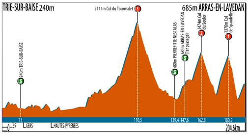
Pau - Peyragudes-Les Agudes.

mtOtxWK.png

Bagnères-de-Luchon – Foix.

I took 2 days off from posting to complete these 2 stages below. I won't talk about the first one as it's just a copy of 2011 stage. It's purpose is to have a proper MTF and to maybe slightly wear of some legs for the next stage. I expect a similar scenario to 2011 and 2015 stages – a roughly 10-man dash to the finish line.

Tour de France by railxmig – stage 15. Saint-Gaudens - Plateau de Beille, 169km, ~4100 asc.
u2SD8lB.jpg

TuGVyE9.png


Climbs:
Col de Portet-d'Aspet - 4,3km, 9,7%, 2 cat. 1069m
Col de la Core - 14km, 5,8%, 1 cat. 1395m
Col de Latrape - 5,5km, 7,4%, 2 cat. 1110m
Col d'Agnès - 10km, 8,2%, 1 cat. 1570m
Port de Lers - 3,8km, 5,5%, 3 cat. 1517m
Plateau de Beille - 15,8km, 7,9%, HC cat. 1780m

Start: Saint-Gaudens, Rue des Compagnons du Tour de France
Km 0: Miramont-de-Comminges, D905, 3,3km from the start
Finish: Plateau de Beille
Sprint: Castillon-en-Couserans, Avenue Noël Peyrevidal, 250m straight
Feed zone: Seix, Route d'Espagne

Start - km 0:
Rue des Compagnons du Tour de France - Rue de la République - Boulevard Louis Pasteur - Boulevard Eugène Azémar - Boulevard Jean Bepmale - Place de Barbastro - Avenue Henri Montagut - Avenue du Président Kenned - Avenue André Bouery - Pont de Miramont-de-Comminge - Miramont-de-Comminges, D905

Tour de France by railxmig – stage 16. Foix - Llívia, 212km, ~3200m asc.
KzV3x8W.jpg

NkoHCoH.png


Climbs:
Col de Montségur - 4,7km, 8%, 2 cat. 1059m
Col de Pailhères - 16,7km, 7,3%, HC cat. 2001m
Col de Puymorens - 28,1km, 4,2%, 1 cat. 1920m
Côte de la Griole - 4,5km, 7%, 2 cat. 1559m

Start: Foix, Allées de Villote
Km 0: Foix, Route d'Espagne, 3,3km from the start
Finish: Llívia, Avinguda de Catalunya, 140m straight
Sprint: Quillan, Boulevard Charles de Gaulle, 200m straight
Feed zone: Saint-Martin-Lys, D117
Start - km 0: Allées de Villote - Cours Bouycheres - Avenue de Barcelone - Route d'Espagne

Sterrato:
Estavar - 1,2km
La Griole - 3,2km
Carrer de Llívia España - 2,6km

I had two versions of this stage prepared. I initially rejected the idea i finally went with. While the first one with Pailhères and Puymorens was easier to draw it was probably an easier version of this stage. I abandoned the realistic part of this race long time ago so i just decided to have fun and not care about anything. My philosphy of designing a stage/race was always heavily based on the realistic nature of such piece. This time i decided just to take the oppurtunity.

I don't know if anyone ever came up with such an idea to finish in Llívia in such fashion but i guess i'm not the first one. Sadly the search engine in this forum seems to be a bit wonky so i don't know if such a finish ever featured in this thread. Maybe someone in a Vuelta allready did such thing.

eQoJZJ7.jpg

zbHa8jM.jpg

Start in Foix.

Previously i planned a finish in Foix. Now it has a start. It's located on the other side of Allées de Villote, basically parallel to 2012 and i assume 2017 finish. Foix is a former Roman fortress (later it evolved into an actual castle) and an abbey from XII c. In the middle ages it was a capital of a small county just south of Toulouse. The main sights are Château de Foix from XIII-XV c. and Abbatiale Saint-Volusien from XII c.

0eSpRRM.jpg

Château de Foix.

First roughly 80km are on the Foix – Perpignan road. There's a small detour to quite steep Col de Montségur on top of which are the ruins of Château de Montségur from around XIII c. It had strong connection with Cathars. In 1233 it became sort of a capital of Cathars. It was heavilly damaged during the Albigensian Crusade.

imT5a4h.gif

Profile of Col de Montségur.

rdj1TTO.jpg

Château de Montségur.

The descent from Montségur will lead to Puivert where there's another Cathar castle (Château de Puivert) from XII c. Further down the road is Quillan, where an intermediate sprint is located. Not far away is a feed zone, located just after Gorges de la Pierre-Lys. Soon riders leave the Perpignan road in Pont d'Aliès (Axat) and turn towards the 2nd climb of the day – Col de Jau.

First roughly 10km to Sainte-Colombe-sur-Guette in the l'Aiguette valley are false-flat. The main ascent is 13,9km long at 6,6% and it's cat. 1. The road is quite narrow and not in best of conditions. This climb was used in Tour a couple of time, last time in 2001 with Laurent Roux first on top. While it's not an easy climb (a strong cat. 1) the descent should be the main concern. It's not steep with majority of the first 10km at 6-8% and max 10% but with 23km of twisty (18 serpentines in span of 6km) and narrow roads it's highly dangerous.

4KTS9ds.png

Profile of Col de Jau.

sJfuF4z.jpg

One of the serpentines on the descent from Col de Jau.

The descent leads to Catllar – a small town just north of Prades. Prades is the capital and biggest city of Conflent, a historic region at the entrance to Vallée de la Têt – one of the main valleys of Pyrénées-Orientales. Riders will stay in this valley for the next 15km going on N116 Perpignan – Lleida road and leave it in Olette.

sojwdy8.jpg

Picturesque cliffs in the Têt valley.

In Olette riders leave the Lleida road turning into Vallée du Cabrils and start the next climb of the day – Col de la Llose (or Coll de la Llosa in Catalan). Col de la Llose is sort of a harder version of Puymorens while Jau was an easier version of Pailhères. Jau is not really important to this stage outside of its descent. Llose however is very important to this stage. It's topping at over 40km from the finish line but it should be very influential to the last 20km.

First 11km of the ascent are irregular with even short bits of descents and 12% slopes. Next roughly 13,5km to the top are much more regular with slopes between 5-7%. Llose's task is to create a selection good enough to get rid of a majority of riders, who are good on rough terrain. These guys are usually quite bulky so their climbing capabilities are limited. The lesser amount of people, who are used to ride on dirt roads the bigger gaps could be generated in the last kms of this stage. It will be softpedalled, but i still expect a roughly 40-man group at the top. While the road up is narrow and not in the best of conditions thankfully the descent is short and relatively easy.

EIdHdmU.png

Profile of Col de la Llose.

sBFVEun.jpg

Road to the top of Col de la Llose.

The descent will lead to Mont-Louis – the entrace to Haut-Cerdagne from Vallée de la Têt. During the middle ages it was understandably a major citadel defending Cerdagne from the valley. Nowadays the citadel is listed in UNESCO World Heritage Sites list.

LRkK3wp.jpg

Citadel of Mont-Louis.

Next roughly 17km to Llívia are in Haut-Cerdagne back on N116. The race will go close to the main ski area on the French side of Pyrénées-Orientales – Font-Romeu. There are a couple of roads and places for a finish in the area. The highest and hardest one is to the biathlon stadium in Mollera des Clots at 2040m. These climbs are not hard (cat. 3 or easy 2) but combined with Col de la Llose (like i think in the crazy 1976 stage) it can be a quite significant finish. Riders will leave N116 for good in Saillagouse and soon after reach Estavar – a small town adjacent to Llívia, but on the French side of the border.

wdGyRAo.jpg

Font-Romeu.

Just today i managed to find yet another fine dirt road near Llívia. This one is very important as it nullifies the need to cross the finish line from the other side. This section connects Estavar with the northernmost peak of Llívia, basically bypassing the city from north. I assume this road is used mainly for mining as there are some small sand heaps. Maybe something with clay, i don't know. This road seems to be quite rough, with some amount of debris but it should be easily cleared before the race.

gDLBqNk.jpg

Pseudo-lap around Llívia.

7NV1a5Y.jpg

Dirt section from Estavar to Llívia.

Llívia was the historic capital of Cerdagne. It was a quite important citadel in the early middle ages but nowadays it's a rather small town. It became an exclave thanks to the Treaty of Pyrenees in 1659 to end a 25 years war between France and Spain. The main sights are a medieval pharmacy and museum Farmàcia Esteve from XVII c and the remains of Castell de Llívia on top of a nearby hill, from the early middle ages.

JrmXK98.jpg

Llívia.

The sort of lap around Llívia is very difficult. After the initial dirt section there's immediately a cat. 2 climb to la Griole – a camping site on the French side of the border near Targassonne. It's 4,5km at 7% with some bits of over 10% reaching even 16%. It's a quite narrow road with a times shaky surface quality. Last roughly 3km of this climb are on dirt. Judging from the satelite images it should be in a fine state – not Strade-Bianche quality but better than Tro-Bro Léon. This dirt section finishes when the road reaches D618 on a small plateau roughly 200m after the KOM. The top of this climb is roughly 13km from the finish line.

PUU8xy7.png

Profile of Côte de la Griole.

hNyzyA9.jpg

Road up to la Griole.

From the top there's a roughly 10km long, nice, easy, wide and shallow descent on D618 to Ur. However, that's not the end of difficulties as in Ur riders won't go straight to Llívia but go via an alternate route known as Carrer de Llívia España. Coincidentally this route is also on dirt. It seems to be slightly rougher than the one to la Griole with a couple of filled ponds on the satelite images which means potholes. This dirt section is 2,6km long and it ends 1,1km from the finish line.

wUf6gFp.jpg

Carrer de Llívia España.

The run-in is not easy either as it'll require a descend down to N-154 on Carrer Camí Ral and Carrer d'Encorones before the last 720m on wide and nice N-154 to the finish line.

xJ1b7cG.jpg

ZY55c7q.png

BPQQth2.jpg

Finish in Llívia.

Llívia has a good amount of sterrato paths to offer. I've used three of them but there are at least two more available. There's a roughly 2km long Carrer Concellabre connecting with D30 in La Solana. There's also a much easier 400m long path directly to D618 on a small plateau above Cereja. I will probably come back to Llívia as it should be a fine place for a hilly/medium mountain one-day race including sterrato and nearby ski stations like Font Romeu and Egat.

I have no clue what will happen on these sterrato bits. It's not Tro-Bro Léon and on paper it's much harder than Strade Bianche. I assume by the time there won't be any specialists in the reduced Peloton. I guess Sky might have the best chance to pose problems with Kwiato and mainly GT keeping things intact. I guess even on a sunny weather the gaps should be noticeable, but i have no clue how big they can be and who will gain the most but the last 20km around Llívia should be very entertaining.

If the weather will be very awful then the alternate route can bypass the dirt bits and go entirely on asphalt with a climb on D33 from Estavar to Egat (Col d'Egat – 7km, 6%, cat. 2) and then a 16km long false-descent to Llívia using the regular N-154 road rather than alternatives. Then it should be a much easier race ending with a 20-30-man sprint.

Now finally back to my original post.

Tour de France by railxmig – stage 17. Muret - Villeneuve-sur-Lot, 199km, ~1300m asc.
XwLgfN4.jpg

4twpLgF.png


Start: Muret, Rue Castelvielh
Km 0: Muret, Route de Rieumes, 3,1km from the start
Finish: Villeneuve-sur-Lot, Avenue d'Agen, 400m straight
Sprint: Verdun-sur-Garonne, Route d'Auch, 5,7km straight
Feed zone: Labastide-du-Temple, Goubet, Route de Lafrancaise

Climbs:
Côte de Saint-Georges - 1,1km, 9,6%, 3 Cat. 180m
Côte de Haut-Castel - 1,8km, 5,9%, 4 Cat. 217m
Côte de Lauzerte - 1,2km, 6,6%, 4 cat. 184m
Côte des Vignals - 2,7km, 4,5%, 4 Cat. 231m
Côte de Terre-Nègre - 2,4km, 4,1%, 4 cat. 254m
Côte de Couyssels - 2,6km, 3,7%, 4 Cat. 230m
Côte de Cap de l'Homme - 3km, 4,1%, 4 cat. 208m
Côte de Lagrémie - 1,1km, 10%, 3 cat. 191m

Start - km 0:
Rue Castelvielh - Rue Clément Ader - Place de la République - Place de la Paix - Place du Languedoc - Avenue Saint-Germier - Boulevard de Lamasquère - Route de Rieumes

Most of this stage comes from an older Fleurance – Marmande stage from my 2nd Tour (the one starting in Avignon). It later evolved into this:

OcHHNrr.png

Blagnac – Bergerac.

I finally ended up with Villeneuve-sur-Lot and a quite tough cat. 3 Côte de Lagrémie only 5,5km from the finish line. There might be some GC movement possible but considering it's at the end of this Tour, so the time splits in GC should be relatively big and the next stage is a TT i doubt there will be any GC action. It should be a nice battleground for the breakaway though.

This stage starts in Muret on Rue Castelvielh. Muret is just south of Toulouse. It may look smallish but it has 25 000 inhabitants. Muret comes from a Roman villa. The main event in Muret's history was a nearby battle in 1213 between Crusaders Simon IV and Catharist, Arangonese and Catalan forces of Peter II. It was one of the main events of the Albigensian Crusade which managed to get rid of Cathars and join the Languedoc to France. Muret once hosted a Tour stage. It was in 2015 to Rodez, which was won by Greg Van Avermaet.

zsYlWaR.jpg

TDR7BqY.jpg

Start in Muret.

9LRW95T.jpg

Eglise Saint-Jacques de Muret.

This stage goes through the hills of Lot and Garonne – mainly Quercy (a former province) and Agenais. There's a lot of cat. 4 hills. Last two of them are part of Agenais while the rest is in Quercy. Both these regions are quite known for hilltop towns like Lafrançaise, Lauzerte, Pujols or Penne-d'Agenais. This whole region looks like a more densly forested Tuscany and seeing the architecture of the towns it's really not that far away from Italy.

wmUNv0l.jpg

Centre of Lauzerte.

jUjkEE4.jpg

Montaigu-de-Quercy.

Most of the roads on this stage are nice and wide. The only exception are the last roughly 15km where some narrower bits shows up but nothing really challenging. This stage does use small amount of national roads – N224, which for some reason is national and like 300m of Périgueux – Lourdes N21.

While the very bumpy 50km in Quercy does look a bit intimidating the main action should be held on the last two hills – Côte de Cap de l'Homme and Côte de Lagrémie. Côte de Cap de l'Homme is quite long but not really special with 3km at 4,1% (max 8%). The main difficulty is Côte de Lagrémie topping about 5,5km from the finish line. It's 1,1km at a very stable 10% (max 12%). It's on a slightly narrower road but the descent is nice and wide (max 9%). The descent from Lagrémie goes through Pujols and then down to Villeneuve-sur-Lot. The finish line is on Avenue d'Agen, at the end of a 400m straight.

lEOofuB.jpg

Road up to Côte de Lagrémie.

Villeneuve-sur-Lot comes from Gajac, which was destroyed during the Albigensian Crusade. It lies on the Lot river, which is littered with manor houses and small castles like Château de Favols or Château de la Sylvestrie. Tour de France finished here twice. First in 1996 won by Massimo Podenzana and in 2000 won by Erik Dekker.

IBaiahb.jpg

h0Cu6Zw.png

bM5jeuw.jpg

Finish in Villeneuve-sur-Lot.

hsk6ECl.jpg

Villeneuve-sur-Lot.

Next 2 stages are very important and because they'll wander aimlessly around Dordogne expect hilly, twisty, narrow and wet roads. Apparently i'm very cynical.
 
railxmig said:
@fauniera, there's quite a lot of really fine quality sterrato trails just north of Ermita de la Trinitat. I see a roughly 20km long track from Begues to Sant Pere de Ribes (north of Sitges) supposedly called Camí Parc del Garraf which is almost entirely on sterrato. This track should end roughly 8km from the finish line. This entire stretch of road is on streetview. There also seems to be a couple of alternative tracks nearby which may work as well.

Don't worry, there will be plenty of sterrato in my Vuelta. We are nearly there. ;)
 
I don't like Plateau de Beille MTF that much in the last week of a GT, railxmig. Goulier-Neige is not that far away and suitable for attacks before the last climb. It would be a 1C climb:
GoulierNeige.gif

And to not make the stage very short you canstart in Lannemezan and climb Mente before Portet d'Aspet and you have a stage like this:
https://www.la-flamme-rouge.eu/maps/viewtrack/hd/79132
The Llivia and Villeneuve sur Lot stages are very innovative, especially the first one and these stages after Goulier-Neige MTF can be perfect.


@fauniera Great stage with a nice murito finish. Very excited to have what you have next in store. But your images of Ermita de la Trinitat don't work because they are probably imgur.
 
Giro d'Italia
I've been planning this version of the "Corsa Rosa" for quite some time now, and have postponed it because of some similarities with railxmig's. So, here goes... you're welcome to laugh, it probably won't be that good :D .

Stage 1: Lecce -> Lecce
9.7km
20px-Time_Trial.svg.png
Individual time trial
1S8vyBF.png

mv0IjBd.png


The Giro gets underway with an individual time trial in one of the major cities in the Apulia region: Lecce. Founded in 200BC and conquered by the Romans in the 3rd century, it was later taken over by the Normans and then by the Sicilian Empire, becoming one of the most important cities in southern Italy. Today, one can visit the Church of the Holy Cross, and also the 12th century Cathedral. There is also a Roman Amphitheatre here, which was able to seat 25,000 in the 2nd century. Now, though, it is half buried.

(DISCLAIMER = I am not a specialist in history, especially Italian history. There are some people who could probably give a much better historical POV :D. I'll mostly stick to the sporting side.)

The riders leave from the Porta Napoli, a gate built to commemorate Charles V, and one of the three used to enter the historical centre. The 9.7km long route features a mix of turns and straights, so basically it's a classic inner-city ITT. There's a twisty bit after the time check, with 11 turns in the space of 1.2km, and this is the only true test of the day. It's pan flat, so nothing to write about for KOM.

Start: Lecce, Piazzetta Arco di Trionfo
Finish: Lecce, Via Garibaldi
Intermediate time check: Lecce, Viale Gallipoli
 

TRENDING THREADS