- Feb 20, 2010
- 33,248
- 15,772
- 28,180
Nordic Series 5: Bessans-Haute Maurienne
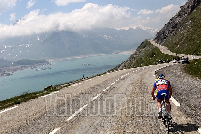
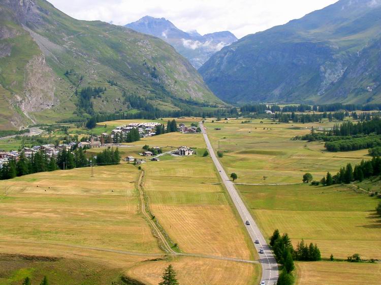
The Maurienne valley is en vogue with ASO. Although the fact that so many prominent passes are connected directly to it has meant it's always been a key location for the Tour - after all, the Col de la Madeleine, Col du Glandon, Col du Télégraphe/Galibier north side, Col de la Croix de Fer and Col de l'Iseran are all connected to the valley, as are the ski stations of Valfréjus which was introduced to the Dauphiné recently, La Toussuire, Valmeinier which has been used in l'Avenir, and other minor stations. The Lacets de Montvernier and the Col de Chaussy are other recent discoveries in the region for ASO, and valley towns such as Saint-Jean-de-Maurienne and Modane are regular hosts of the Tour and the Dauphiné, and so there's been a lot of racing through an area you could throw a blanket over in recent years.
At the easternmost end of the valley, however, close to the base of the Col de l'Iseran, the highest altitude paved pass in Europe, lies the small village of Bessans, known as the Nordic sports mecca of the French Alps, with some 80km of marked trails and a biathlon stadium. Because of its convenient valley location meaning generally very reliable snow, and the high altitude meaning good conditioning training as well as an extended ski season, Bessans has become very popular as a training centre with both amateurs and professionals, as well as hosting an annual round of Euroloppet, the second-level ski marathon Tour calendar, and on several occasions national and international tournaments in both XC skiing and biathlon - particularly the latter, which has held its summer World Championships here once (in 2008) and the IBU Cup, the sport's second-tier competition, on several occasions from the late 90s through to 2011-12 when Le Grand Bornand usurped it as the French venue of choice owing to its easier accessibility.
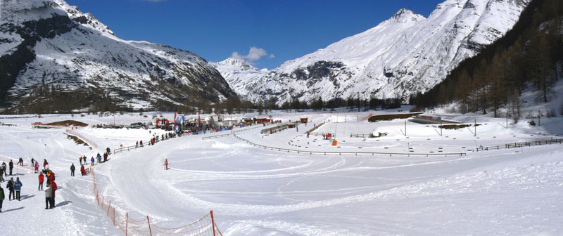
Bessans is not the largest biathlon venue out there - certainly doesn't compare to, say, Nové Město or Ruhpolding for size or atmosphere - but it does have the benefit of several kilometres of tarmacked trails and a large plateau in which it is located, which along with the village itself around the corner from the snowsports venue having a road that bypasses it and a road which runs right through its core, lends itself to logistical use to make the biathlon arena usable as a cycling stage host. Oftentimes athletes will be staying in nearby Modane or Aussois and being driven in for competition, but there's plenty of room to park the race caravan at Bessans. And plenty of scenery too.
You can see a bit of the trails here (accompanied by dreadful music, unfortunately). Either way, a stage finishing at Bessans can come from in the Maurienne valley or over the Iseran, so opens up a few different possibilities for us. I'm particularly fond of a styled finish I've used twice in my stage proposals, which bears some resemblance to the finishes in Ridnaun-Val Ridanna. The other thing, of course, is that because we're very much in the Haute-Maurienne to finish in Bessans, the altitude is still pretty significant so although we can descend into the finish, we're still at over 1700m at the end, which means that this will undoubtedly play a role as well.
One drawback for Bessans is that the races that can use it are limited almost certainly to the French races, even given its extreme proximity to Italy; it is too far away from the French locales that pay for the Giro della Valle d'Aosta, which leaves us with the Giro d'Italia; the problem then becomes the weather, because unless it comes off the back of another mountain stage into France, the only logical options would require either the stage into Bessans or the following stage to crest either Galibier or Iseran; not only are both highly unreliable at that time of the year due to their height, but also their summits would almost necessitate the Cima Coppi, which could be problematic as only twice since the Cima was introduced in 1965 has the Giro seen the race's ceiling on a climb entirely outside of Italy - the Großglockner in 1971 and the Col d'Izoard in 1982. The only way in and out therefore would likely be the Modane tunnel or the Col du Mont-Cenis. However, the French races could well pass through Italy en route to Bessans, and then their time of year - June and July - would make them much more suited to utilizing the stadium within a cohesive race route.
Stage proposal #1: Barcelonnette - Bessans-Haute Maurienne, 203km

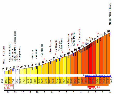
The first proposal is a major mountain stage which traverses Italian terrain as it takes in a number of classic climbs, but tweaked to make major use of a climb which all too rarely serves as a significant difference-maker. The Col du Mont-Cenis is an absolute brute, long and punishing, but due to an inconvenient location only crested a surprising seven times in the Tour or Giro, two of which were in the 2013 Giro's weather-affected incursion into France. And the last time the Tour de France climbed the far tougher Italian side of Mont-Cenis, it was one day after Lance Armstrong had decimated everybody with a show of strength into Sestrières in 1999; the stage was from Sestrières to Alpe d'Huez and was won by Giuseppe Guerini despite an incident with a spectator on the final iconic climb. I am putting the KOM points up at the Plan des Fontainettes, which signals the end of the climbing and comes with 24km remaining in my stage; the climb to this point is essentially 25km @ 6,4% comprising three different climbs of 7-8% linked by short false flats.
Before the riders get there, however, we need to make sure their legs are tired, so I've taken them over some well-trodden summits - the Vars and Izoard - to get them to Briançon, where we can enter Italy over the Col de Montgenèvre. If desired, we could loop around Sestrières here as there are two parallel roads into the resort from the west, however I felt it unnecessary as we couldn't bring the climb any closer to Mont-Cenis; the issue of connectivity would remain as there is a fairly lengthy period of valley riding from Cesana Torinese (sitting beneath Cesana-San Sicario, which I wanted to do a post on and may still, but given that the biathlon venue has closed and is now to be turned into tennis courts, it would seem a bit odd to then host a major race to showcase its wintersport heritage!!!) to Susa.
After the long and challenging climb to Mont-Cenis and the plateau as the road rolls around the edges of the Lac du Mont-Cenis, there's a descent into Lanslevillard before a final sting in the tail, and one of the best things about a stage in the upper part of the Maurienne valley - a short and unwelcome climb called the Col de la Madeleine. Not to be confused with its more illustrious namesake to the west, which also rises out of the Maurienne valley, this Col de la Madeleine is short - just under 4km - and only really merits cat.3 status, but the first two kilometres being at 8,5% will be most unwelcome this late in the stage, and may well be underestimated, as well as giving a final platform for an attack if the riding is conservative; from the summit to the end of the stage is just 5,5km of chasing through the valley; plus the potential effect of altitude since we've been above 2000m three times in the stage and then have this punchy climb at around 1700m could mean that tired legs will see more sizable gaps emerge late on than you might expect.
Stage proposal #2: Cuneo - Bessans-Haute-Maurienne, 215km

My second proposal is the only one that might work as a Giro stage, but is more likely to be appended to a Tour stage such as 2008's to Prato Nevoso or perhaps the 2016 Giro stage to Sant'Anna di Vinadio. Another option would be after Lombarde to clone the end of the 1999 Borgo San Dalmazzo stage, or perhaps a MTF at the Col de Tende like the 2005 Giro. Either way, we'd be heading from Cuneo in a stage bearing some resemblance to the 2009 replacement Cuneo-Pinerolo stage.
The stage is long to try to ensure there's some suffering late on, because the opening is flat, and then we have the long, tortuous gradual climb up to Sestrières from the east. Although little of it is anything more than false flat and only certain parts can really be called a mountain pass per se, there is over 50km of climbing to be done between Pinerolo and the ski station, so what it lacks in complexity it makes up for in relentlessness. From the end of the descent into Cesana Torinese, the route clones the previous stage, although it tricks people somewhat with a modification to the climb of Mont-Cenis, forgoing a standard HC climb in favour of two cat.1 climbs (if doing in the Giro, the first part is borderline cat.1/cat.2, the second is just cat.2, however because this is the Giro GPM, we could just not give any points for the first climb and give cat.1 at the very top). This allows us to utilize the secondary climb to the Italian town of Moncenisio (Italian for Mont-Cenis, hence in my Gallicized TdF profile it has been rechristened "Côte du Mont-Cenis" to differentiate it from the more famous Col) that was first unearthed by Zomegnan in 2009, 15km at over 6% but with the final 4km averaging a not inconsiderable 10%, with the summit just over 40km from the line, this could take a few by surprise.
There's then four kilometres of downhill false flat that leads us back onto the traditional Col du Mont-Cenis at around the 18,5km marker of this profile - yielding around 13km @ 6% remaining for the normal face of Mont-Cenis, so hardly a walk in the park either, although admittedly the gradients do not get quite as punishing as in Moncenisio's final few kilometres. Another key feature in this stage's deceptive difficulty is that the last three climbs are all lopsided, and so there's far less time recovering downhill than there is going uphill, and that should have a cumulative effect by the time we come to the end of a 215km stage.
Stage proposal #3: Chambéry - Bessans-Haute-Maurienne, 150km

This is something of an experimental stage as well as a bit of a curveball - after all, who would expect a stage in the heart of the Alps to feature so few notable climbs? This is in style perhaps a bit reminiscent of the Pfalzen stage in the Giro a few years ago won by Ion Izagirre, ostensibly a transitional stage that sat in the middle of the Dolomites.
The point of that stage was that they were already well into the mountains but needed to switch from sector to sector without giving us 5 or 6 straight mountain stages and killing the racing on other days. This stage would give us a perfect way to transition from brutal mountains in the Jura or the northern Alps (places like Grand-Colombier, Le Semnoz, Mont Revard, Mont du Chat, or maybe to the west, the Chartreuse Alps north of Grenoble) to start a final blast of classic Alpine climbs like Galibier, Izoard and Alpe d'Huez. Because strictly speaking it's nothing more than a flat-to-hilly stage, but late in a race like the Tour it's going to the break; however you've still got the potential for GC action with that banana skin of the Col de la Madeleine, but also you have the bonus trickery that comes with an ostensibly flat stage which finishes at 1500m higher altitude than it starts. None of the climbs are especially tough although with the stage being pretty short, the Côte d'Aussois finishing 30km from the line ought to create some movement in the battle to take the stage from the break. And given how keen they've been to showcase their region through bike races in recent years, the tourist board of the Maurienne valley should be happy to see the race spending so much time transiting between their valley towns...
Stage proposal #4: Aosta - Bessans-Haute-Maurienne, 152km

This is the "wildcard" entry, the option for coming from the north east, via Iseran. Sure, there are lots of options for how to get to Bourg-Saint-Maurice before Iseran (a favourite being over Mont Bisanne, and then the Cormet de Roseland via the Col du Pré), but this again sees us border hopping in from the Italian city of Aosta. I know not everybody shares my love of the Valle d'Aosta but I do feel it's a tragically underused area; this particular stage could form the second part of a monster Tour weekend mixing classics with rarities; I would have a stage from Chamonix, Châtel or somewhere similar on the Saturday, descending into Switzerland and going over either the Col du Lein or Champex before the Col du Grand-St-Bernard and then a mountaintop finish at Pila, a real HC beast only seen twice (in 1987 and 1992) in the Giro, and then on the Sunday, this stage from Aosta back into France.
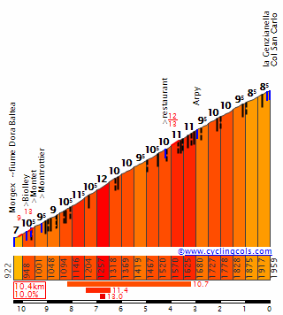
Although not the most brutal climb ever devised, Combes comes early enough to ensure we get a strong breakaway, before we head back to France by the route they should have chosen in 2009; Petit-St-Bernard is a very consistent, tempo grinding kind of climb, which is fine in its role in this stage, but preceding it with the Colle San Carlo (known in French as the Col Saint-Charles) with its legit HC 10km at 10% - albeit more consistent than the Zoncolans and Anglirus of this world - can make it more impactful. And also, including such a climb as San Carlo means this is a truly versatile climbers stage, with all manner of climbs; the all important one at the end is interminable, mid-gradient and high altitude, whereas this is all steepness and gritted teeth, especially with less than an hour's riding done before they start.
The climb has only been seen four times; three times from 1962 to 1973 (in 1970 it was even used as early as stage 3!), the latter of which from the easier side, before a 33 year layoff until Zomegnan brought it back in 2006 in as close to a Unipuerto stage as you can reasonably get - sorely disappointing when you consider the alternatives in a climb-rich area like Aosta. Anyhow - Leonardo Piepoli won the stage.
Backing immediately into the final 13km of the northern side of Petit-St-Bernard means that we preserve the only really tough parts of that ascent. But instead of doing the traditional thing of descending all the way into Bourg-Saint-Maurice, we instead descend the most consistent and least interesting side of PSM before hanging a left and taking on the final 4km of the Côte de Montvalezan, giving us a short steep climb to add to the collection of climbing styles as well as giving greater connectivity to the big monster climb of the stage which is, of course, L'Iseran.
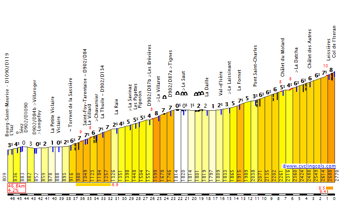
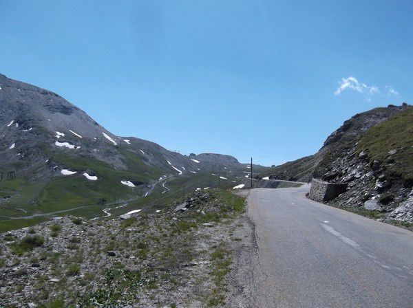
This two-stepped ascent is written deep into cycling lore despite remaining a special attraction, having only been crested 7 times (it would have been 8 but it was one of the climbs nullified in 1996) in an 80 year association with the Tour. The last time it was seen was 2007, when only the second step was climbed, early in the stage, en route to Briançon; as you can see, due to difficulty and altitude even just the second part was categorized HC, so the whole ascent definitely merits it; as we only join the climb at Sainte-Foy-Tarentaise, it essentially consists of a 13km @ 6% ascent (a legit cat.1) before a few kilometres of flat around a lake leading into the legendary ski town of Val d'Isère (known almost exclusively for Alpine skiing of course, but one of the true meccas of that format), then another 16km @ just under 6% up to a 2770m summit - absolutely brutal, and cresting just 21km from the line in this action packed stage.
The fact that it's so rarely climbed means there's still a level of mythos about the Col de l'Iseran that a lot of the other mythical rarities are beginning to lose; despite this, it's never really laid itself out as the preserve of the truly greatest climbers; indeed the one time it's really been notable was in Claudio Chiapucci's 1992 solo. But having now not been climbed in its entirety for 25 years, the presence of a ski station that could pay to host racing just 20km from its summit is a good motivation, no?
The Maurienne valley is en vogue with ASO. Although the fact that so many prominent passes are connected directly to it has meant it's always been a key location for the Tour - after all, the Col de la Madeleine, Col du Glandon, Col du Télégraphe/Galibier north side, Col de la Croix de Fer and Col de l'Iseran are all connected to the valley, as are the ski stations of Valfréjus which was introduced to the Dauphiné recently, La Toussuire, Valmeinier which has been used in l'Avenir, and other minor stations. The Lacets de Montvernier and the Col de Chaussy are other recent discoveries in the region for ASO, and valley towns such as Saint-Jean-de-Maurienne and Modane are regular hosts of the Tour and the Dauphiné, and so there's been a lot of racing through an area you could throw a blanket over in recent years.
At the easternmost end of the valley, however, close to the base of the Col de l'Iseran, the highest altitude paved pass in Europe, lies the small village of Bessans, known as the Nordic sports mecca of the French Alps, with some 80km of marked trails and a biathlon stadium. Because of its convenient valley location meaning generally very reliable snow, and the high altitude meaning good conditioning training as well as an extended ski season, Bessans has become very popular as a training centre with both amateurs and professionals, as well as hosting an annual round of Euroloppet, the second-level ski marathon Tour calendar, and on several occasions national and international tournaments in both XC skiing and biathlon - particularly the latter, which has held its summer World Championships here once (in 2008) and the IBU Cup, the sport's second-tier competition, on several occasions from the late 90s through to 2011-12 when Le Grand Bornand usurped it as the French venue of choice owing to its easier accessibility.
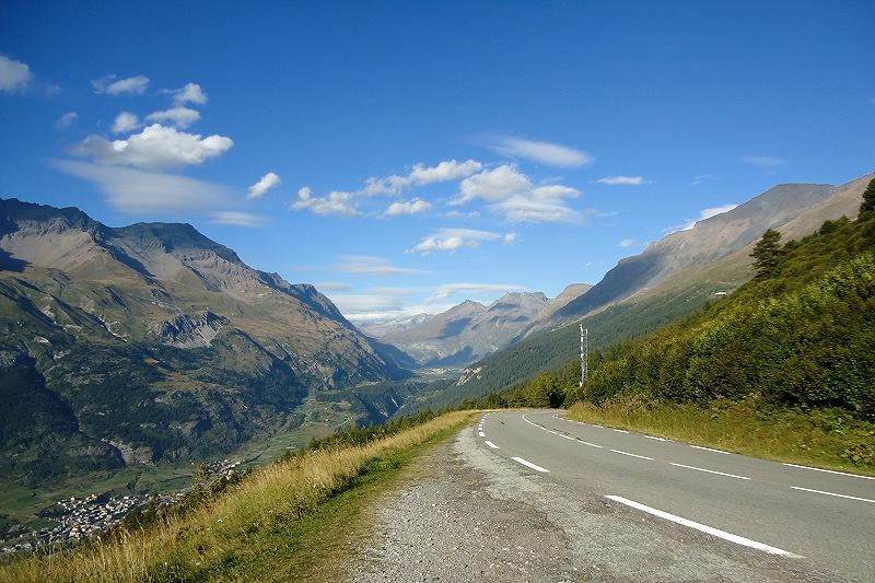
Bessans is not the largest biathlon venue out there - certainly doesn't compare to, say, Nové Město or Ruhpolding for size or atmosphere - but it does have the benefit of several kilometres of tarmacked trails and a large plateau in which it is located, which along with the village itself around the corner from the snowsports venue having a road that bypasses it and a road which runs right through its core, lends itself to logistical use to make the biathlon arena usable as a cycling stage host. Oftentimes athletes will be staying in nearby Modane or Aussois and being driven in for competition, but there's plenty of room to park the race caravan at Bessans. And plenty of scenery too.
You can see a bit of the trails here (accompanied by dreadful music, unfortunately). Either way, a stage finishing at Bessans can come from in the Maurienne valley or over the Iseran, so opens up a few different possibilities for us. I'm particularly fond of a styled finish I've used twice in my stage proposals, which bears some resemblance to the finishes in Ridnaun-Val Ridanna. The other thing, of course, is that because we're very much in the Haute-Maurienne to finish in Bessans, the altitude is still pretty significant so although we can descend into the finish, we're still at over 1700m at the end, which means that this will undoubtedly play a role as well.
One drawback for Bessans is that the races that can use it are limited almost certainly to the French races, even given its extreme proximity to Italy; it is too far away from the French locales that pay for the Giro della Valle d'Aosta, which leaves us with the Giro d'Italia; the problem then becomes the weather, because unless it comes off the back of another mountain stage into France, the only logical options would require either the stage into Bessans or the following stage to crest either Galibier or Iseran; not only are both highly unreliable at that time of the year due to their height, but also their summits would almost necessitate the Cima Coppi, which could be problematic as only twice since the Cima was introduced in 1965 has the Giro seen the race's ceiling on a climb entirely outside of Italy - the Großglockner in 1971 and the Col d'Izoard in 1982. The only way in and out therefore would likely be the Modane tunnel or the Col du Mont-Cenis. However, the French races could well pass through Italy en route to Bessans, and then their time of year - June and July - would make them much more suited to utilizing the stadium within a cohesive race route.
Stage proposal #1: Barcelonnette - Bessans-Haute Maurienne, 203km
The first proposal is a major mountain stage which traverses Italian terrain as it takes in a number of classic climbs, but tweaked to make major use of a climb which all too rarely serves as a significant difference-maker. The Col du Mont-Cenis is an absolute brute, long and punishing, but due to an inconvenient location only crested a surprising seven times in the Tour or Giro, two of which were in the 2013 Giro's weather-affected incursion into France. And the last time the Tour de France climbed the far tougher Italian side of Mont-Cenis, it was one day after Lance Armstrong had decimated everybody with a show of strength into Sestrières in 1999; the stage was from Sestrières to Alpe d'Huez and was won by Giuseppe Guerini despite an incident with a spectator on the final iconic climb. I am putting the KOM points up at the Plan des Fontainettes, which signals the end of the climbing and comes with 24km remaining in my stage; the climb to this point is essentially 25km @ 6,4% comprising three different climbs of 7-8% linked by short false flats.
Before the riders get there, however, we need to make sure their legs are tired, so I've taken them over some well-trodden summits - the Vars and Izoard - to get them to Briançon, where we can enter Italy over the Col de Montgenèvre. If desired, we could loop around Sestrières here as there are two parallel roads into the resort from the west, however I felt it unnecessary as we couldn't bring the climb any closer to Mont-Cenis; the issue of connectivity would remain as there is a fairly lengthy period of valley riding from Cesana Torinese (sitting beneath Cesana-San Sicario, which I wanted to do a post on and may still, but given that the biathlon venue has closed and is now to be turned into tennis courts, it would seem a bit odd to then host a major race to showcase its wintersport heritage!!!) to Susa.
After the long and challenging climb to Mont-Cenis and the plateau as the road rolls around the edges of the Lac du Mont-Cenis, there's a descent into Lanslevillard before a final sting in the tail, and one of the best things about a stage in the upper part of the Maurienne valley - a short and unwelcome climb called the Col de la Madeleine. Not to be confused with its more illustrious namesake to the west, which also rises out of the Maurienne valley, this Col de la Madeleine is short - just under 4km - and only really merits cat.3 status, but the first two kilometres being at 8,5% will be most unwelcome this late in the stage, and may well be underestimated, as well as giving a final platform for an attack if the riding is conservative; from the summit to the end of the stage is just 5,5km of chasing through the valley; plus the potential effect of altitude since we've been above 2000m three times in the stage and then have this punchy climb at around 1700m could mean that tired legs will see more sizable gaps emerge late on than you might expect.
Stage proposal #2: Cuneo - Bessans-Haute-Maurienne, 215km
My second proposal is the only one that might work as a Giro stage, but is more likely to be appended to a Tour stage such as 2008's to Prato Nevoso or perhaps the 2016 Giro stage to Sant'Anna di Vinadio. Another option would be after Lombarde to clone the end of the 1999 Borgo San Dalmazzo stage, or perhaps a MTF at the Col de Tende like the 2005 Giro. Either way, we'd be heading from Cuneo in a stage bearing some resemblance to the 2009 replacement Cuneo-Pinerolo stage.
The stage is long to try to ensure there's some suffering late on, because the opening is flat, and then we have the long, tortuous gradual climb up to Sestrières from the east. Although little of it is anything more than false flat and only certain parts can really be called a mountain pass per se, there is over 50km of climbing to be done between Pinerolo and the ski station, so what it lacks in complexity it makes up for in relentlessness. From the end of the descent into Cesana Torinese, the route clones the previous stage, although it tricks people somewhat with a modification to the climb of Mont-Cenis, forgoing a standard HC climb in favour of two cat.1 climbs (if doing in the Giro, the first part is borderline cat.1/cat.2, the second is just cat.2, however because this is the Giro GPM, we could just not give any points for the first climb and give cat.1 at the very top). This allows us to utilize the secondary climb to the Italian town of Moncenisio (Italian for Mont-Cenis, hence in my Gallicized TdF profile it has been rechristened "Côte du Mont-Cenis" to differentiate it from the more famous Col) that was first unearthed by Zomegnan in 2009, 15km at over 6% but with the final 4km averaging a not inconsiderable 10%, with the summit just over 40km from the line, this could take a few by surprise.
There's then four kilometres of downhill false flat that leads us back onto the traditional Col du Mont-Cenis at around the 18,5km marker of this profile - yielding around 13km @ 6% remaining for the normal face of Mont-Cenis, so hardly a walk in the park either, although admittedly the gradients do not get quite as punishing as in Moncenisio's final few kilometres. Another key feature in this stage's deceptive difficulty is that the last three climbs are all lopsided, and so there's far less time recovering downhill than there is going uphill, and that should have a cumulative effect by the time we come to the end of a 215km stage.
Stage proposal #3: Chambéry - Bessans-Haute-Maurienne, 150km
This is something of an experimental stage as well as a bit of a curveball - after all, who would expect a stage in the heart of the Alps to feature so few notable climbs? This is in style perhaps a bit reminiscent of the Pfalzen stage in the Giro a few years ago won by Ion Izagirre, ostensibly a transitional stage that sat in the middle of the Dolomites.
The point of that stage was that they were already well into the mountains but needed to switch from sector to sector without giving us 5 or 6 straight mountain stages and killing the racing on other days. This stage would give us a perfect way to transition from brutal mountains in the Jura or the northern Alps (places like Grand-Colombier, Le Semnoz, Mont Revard, Mont du Chat, or maybe to the west, the Chartreuse Alps north of Grenoble) to start a final blast of classic Alpine climbs like Galibier, Izoard and Alpe d'Huez. Because strictly speaking it's nothing more than a flat-to-hilly stage, but late in a race like the Tour it's going to the break; however you've still got the potential for GC action with that banana skin of the Col de la Madeleine, but also you have the bonus trickery that comes with an ostensibly flat stage which finishes at 1500m higher altitude than it starts. None of the climbs are especially tough although with the stage being pretty short, the Côte d'Aussois finishing 30km from the line ought to create some movement in the battle to take the stage from the break. And given how keen they've been to showcase their region through bike races in recent years, the tourist board of the Maurienne valley should be happy to see the race spending so much time transiting between their valley towns...
Stage proposal #4: Aosta - Bessans-Haute-Maurienne, 152km
This is the "wildcard" entry, the option for coming from the north east, via Iseran. Sure, there are lots of options for how to get to Bourg-Saint-Maurice before Iseran (a favourite being over Mont Bisanne, and then the Cormet de Roseland via the Col du Pré), but this again sees us border hopping in from the Italian city of Aosta. I know not everybody shares my love of the Valle d'Aosta but I do feel it's a tragically underused area; this particular stage could form the second part of a monster Tour weekend mixing classics with rarities; I would have a stage from Chamonix, Châtel or somewhere similar on the Saturday, descending into Switzerland and going over either the Col du Lein or Champex before the Col du Grand-St-Bernard and then a mountaintop finish at Pila, a real HC beast only seen twice (in 1987 and 1992) in the Giro, and then on the Sunday, this stage from Aosta back into France.
Although not the most brutal climb ever devised, Combes comes early enough to ensure we get a strong breakaway, before we head back to France by the route they should have chosen in 2009; Petit-St-Bernard is a very consistent, tempo grinding kind of climb, which is fine in its role in this stage, but preceding it with the Colle San Carlo (known in French as the Col Saint-Charles) with its legit HC 10km at 10% - albeit more consistent than the Zoncolans and Anglirus of this world - can make it more impactful. And also, including such a climb as San Carlo means this is a truly versatile climbers stage, with all manner of climbs; the all important one at the end is interminable, mid-gradient and high altitude, whereas this is all steepness and gritted teeth, especially with less than an hour's riding done before they start.
The climb has only been seen four times; three times from 1962 to 1973 (in 1970 it was even used as early as stage 3!), the latter of which from the easier side, before a 33 year layoff until Zomegnan brought it back in 2006 in as close to a Unipuerto stage as you can reasonably get - sorely disappointing when you consider the alternatives in a climb-rich area like Aosta. Anyhow - Leonardo Piepoli won the stage.
Backing immediately into the final 13km of the northern side of Petit-St-Bernard means that we preserve the only really tough parts of that ascent. But instead of doing the traditional thing of descending all the way into Bourg-Saint-Maurice, we instead descend the most consistent and least interesting side of PSM before hanging a left and taking on the final 4km of the Côte de Montvalezan, giving us a short steep climb to add to the collection of climbing styles as well as giving greater connectivity to the big monster climb of the stage which is, of course, L'Iseran.
This two-stepped ascent is written deep into cycling lore despite remaining a special attraction, having only been crested 7 times (it would have been 8 but it was one of the climbs nullified in 1996) in an 80 year association with the Tour. The last time it was seen was 2007, when only the second step was climbed, early in the stage, en route to Briançon; as you can see, due to difficulty and altitude even just the second part was categorized HC, so the whole ascent definitely merits it; as we only join the climb at Sainte-Foy-Tarentaise, it essentially consists of a 13km @ 6% ascent (a legit cat.1) before a few kilometres of flat around a lake leading into the legendary ski town of Val d'Isère (known almost exclusively for Alpine skiing of course, but one of the true meccas of that format), then another 16km @ just under 6% up to a 2770m summit - absolutely brutal, and cresting just 21km from the line in this action packed stage.
The fact that it's so rarely climbed means there's still a level of mythos about the Col de l'Iseran that a lot of the other mythical rarities are beginning to lose; despite this, it's never really laid itself out as the preserve of the truly greatest climbers; indeed the one time it's really been notable was in Claudio Chiapucci's 1992 solo. But having now not been climbed in its entirety for 25 years, the presence of a ski station that could pay to host racing just 20km from its summit is a good motivation, no?
")