• The Cycling News forum is looking to add some volunteer moderators with Red Rick's recent retirement. If you're interested in helping keep our discussions on track, send a direct message to @SHaines here on the forum, or use the Contact Us form to message the Community Team.

    In the meanwhile, please use the Report option if you see a post that doesn't fit within the forum rules.

    Thanks!

Race Design Thread

Page 270 - Get up to date with the latest news, scores & standings from the Cycling News Community.
Jun 11, 2014
304
0
0
Visit site
Re: Re:

rghysens said:
TromleTromle said:
gregrowlerson said:
This is a fantastic idea and application of it!

Really looking forward to seeing your additional changes to the route post stage 7.

A few cents from my side.
Each one of the rearranged states are significantly more challenging that before - and are greatly designed !
Herein lies the problem - Week 1 now turned into a extremely hard, risky, tense, hill/puncheur race - much tougher even by Guillen-Vuelta standards.

Well, my idea was to point out missed opportunities, not as much creating a "realistic" Tour de France course.

I see, it just confused me that some stages were left as per original design, instead of trying to make the hardest possible standalone routes for each of the stages :razz:

Looking forward to see how you save the dreadfull Izoard stage - if still placed next day after the Telebier
 
Re:

lemon cheese cake said:
Nice Worlds course Brullnux. However two questions: why finish on Great Pulteney Street, like the Tour series did this year, and not on Royal Avenue, like last year's Tour of Britain and the 2015 Tour Series? There is a lot more space and it finishes in sight of the Royal Crescent. That brings me on to my second question: what about riding along the Royal Crescent? Although the cobbles wont do anything, if your showing off the sights of the south west, like Cheddar Gorge, why not show off another famous sight of the south west.
To the first one, I prefer Great Pulteney Street to the Royal Avenue and it's wider I'd say.

As to ridding on the Royal Crescent, I would like to do that but there are bollards on one of the sides, so it's a dead end road. It could be done if you take them out but it's easier to just pass underneath it and by the side.
 
GIRO D'ITALIA

(Wed) stage 4: Maiori - Taburno Camposauro, 161 km

opO67MP.png

rPmb7UC.png


The first serious mountain stage (with 4.400 meters of climbing) takes place in Campania. The start is in Maiori, a few km down the road from yesterday's finish in Amalfi.

ULM0vnO.jpg


The climbing starts immediately with Válico di Chiunzi.

ChiunziS.gif


The next 80 km contain three relatively easy climbs. Things get harder in the massif of Taburno Camposauro, which is the scene of the last 70 km of the stage.

Monte Taburno
Montesarchio%2C_Italia_-_Monte_Taburno.jpg


Monte Taburno is a long climb at 17,8 km, but the gradients are quite shallow.

TaburnoE.gif

nsvCYuV.jpg


The next climb, Colle San Vito, is short but a lot steeper (3 km at 10,5%). The road is quite narrow.

0L3jyV9.png

YVuJqV1.png

acH17Qg.png


After the descent to Vitulano, there is another short and steep climb (1,2 km at 12,5%).

timZHGR.png


The final climb, Monte Alto Rotondi, is 13 km long and has an average gradient of 8,3%. The climb can be broken down to four parts. The first 3 km are fairly easy, the next 4 km are 9,5% steep and are followed by 1,4 km of false flat. The final 4,6 km have an average gradient of 10,1%.

XUuzQFA.png

dDyyeld.png

s366afU.png


finish
70ZPHNw.png
 
GIRO D'ITALIA

(Thu) stage 5: Santa Maria Capua Vetere - Latina, 155 km

lIvRYpj.png

JRjISf8.png


Finally a flat stage with no hills in the finale. One for the sprinters obviously. The run in is unproblematic, the finishing straight is 3 km long.


That guy is standing on the finish line:
GoSSEqu.png


Santa Maria Capua Vetere
Tx83iXX.jpg


Latina
G2XzGcp.jpg
 
@rghysens
Some great stages. I didn't even know the first category climb on stage 15 could be so much closer to the finish but now that I know it this tour route makes me even angrier than it already did.
Two small things I would do differently.
1.) I love the chat - epine combo and would usually prefer that one over the finish which was actually used. However I'm not sure if that would work so early in the race when nobody has to take huge risks yet, therefore I would keep the actual finish.
2.) I don't think making the stage to foix a little bit harder is the right way to improve that stage. Either make it a seriously hard mountain stage and forget the ambush thing or leave it as it is but maybe make stage 12 harder instead. I think that especially stages which were made to cause an ambush don't get better with more climbs. Additional climbs will only mane the ambush harder however tired legs (caused for example by a very hard stage the day before) make it easier to destroy mountain trains which could otherwise neutralize a stage like this.
 
GIRO D'ITALIA

(Fri) stage 6: Nettuno - Todi 220 km

sZ5FhT8.png

BevyS8b.png


The second longest stage of the race brings us from Lazio to the hilltop town Todi in Umbria. Two muri are waiting for the riders inside the final 10 km.

JwXDmSG.png

zRhqruW.png


We approach Todi from the south. The first muro is of the classical "road goes straight up the hill" variety. It is 1 km long and 14,3% steep.

fNEX8bz.png

gVLJJUu.png


After the descent we approach the town again, this time from the northeast. This muro is even steeper than the first one (1,1 km at 15,2%).

HSqeNby.png

oCYSTrj.png


From the top of this little monster there are 2 km left to race, including the final cimb to the city center.

lrVnpIp.png

0HzNg8Y.png


Finish at Piazza del Popolo:

ML3H0tx.jpg


Nettuno
gPbaq9I.jpg


Todi
IfBGife.jpg
 
Todi, town known by its muritos for race designers. Very nice final, fauniera.
Giro d' Italia Stage 20 Trento-Bolzano 249,39 km Mountain
https://www.la-flamme-rouge.eu/maps/viewtrack/hd/128167

KOM SPRINTS:
Passo della Mendola (1st Category, 1369 m, 17.4 Km at 6.5%, Km 63.4)
Forcella di Brez (2nd Category, 1386 m, 6.4 Km at 9.1%, Km 82.7)
Passo Castrin (1st Category, 1793 m, 8.7 Km at 9.1%, Km 96.5)
Passo di Monte Giovo (1st Category, 2100 m, 20.2 Km at 7.1%, Km 168.3)
Passo Pennes (Cima Coppi, 2212 m, 13.9 Km at 9.0%, Km 200.8)
Couldn't find a profile for the hardest side of Mendola, San Giuseppe al Lago side but the last 10,5 km or so is the same with this side:
MendolaE.gif

(there's flammerouge profile but you need to be a member, anyways-for those who are members, flammerouge link: https://www.la-flamme-rouge.eu/maps/viewtrack/hd/56740)

Forcella di Brez:
BrezE.gif


Passo Castrin: (from the intersection with Brezer Joch)
ClozSW.gif


Passo di Monte Giovo:
MonteGiovoW.gif


Passo Pennes:
PennesN.gif


Trento:
TRENTO-1-800x549.jpg


Bolzano:
4218979767.jpeg
 
Thanks a lot. Giovo-Pennes is one of the hardest combos and I agree that Bolzano is too far away. San Martino or Valdurna could have been better choices but I think the stage should have some action because it is stage 20 - and almost the last opportunity (even though stage 21 has Monte Maddalena thrice)
 
Giro d' Italia Stage 21 Pinzolo-Brescia 170,12 km Medium Mountain
https://www.la-flamme-rouge.eu/maps/viewtrack/hd/120059

The final chance for riders if they want to win the race, with the ferasome Monte Maddalena being climbed thrice as the Giro finishes in Brescia!
KOM SPRINTS: Monte Maddalena (1st Category, 805 m, 4.8 Km at 12.4%, Km 101.9) x3

Monte Maddalena x3:
MaddalenaN.gif

https://www.google.com/maps/@45.5612755,10.2822783,3a,61.8y,94.49h,86.03t/data=!3m6!1e1!3m4!1smvrKN4U4ri11Xwe5e9bXkA!2e0!7i13312!8i6656

Pinzolo:
pinzolo-6278.jpg


Brescia:
Castle-of-Brescia-for-Blogville-by-Felipe-Tofani-101.jpg
 
So, final overview:
The link of the whole race: https://www.la-flamme-rouge.eu/maps/tours/view/5355
Total distance: 3592,43 km
There are:
7 high mountain stages (Monte Faito, Monte Cimone, Oropa, Estoul, Maniago, Trento, Bolzano)
5 medium mountain stages (Pescocotanzo, Porto Sant' Elpidio, Montalcino, Tolmezzo, Brescia)
7 flat stages (Terme Luigiane, Taranto, Potenza, Foligno, La Spezia, Pavia, Verona)
2 ITTs (Perugia, Milano; 119,83 km in total)
Though in fairness Brescia is probably a high mountain stage as well looking at the difficulty of Monte Maddalena.

Cima Coppi is Passo Pennes at 2212 meters.
There are 21 first category and 16 second category climbs as well.

6 various uphill finishes:
Terme Luigiane 4C Stage 1
Monte Faito 1C Stage 5
Pescocotanzo Uncategorized Stage 6
Perugia 4C Stage 8 (ITT)
Monte Cimone 2C Stage 11
Estoul 2C Stage 15
 
Oct 4, 2015
417
1
3,030
Visit site
Next project, since there's a real-life Tour underway (plus two fantasy Giri over here), a Tour de France!

While tryng to draw a difficult Tour de France, focusing over the Central Massif and the hills at the Côte d'Azur as transitions between the typical Pyrenees-Alps mountain stages, I realized I was often using racing circuits as start-finish points. So I eventually decided to start all over, this time actually focusing on said circuits.
This tour de France would be an homage to French racing history, starting off from the world-famous Le Mans circuit, making stops at several famous racing circuits throughout France, then finishing with a stage starting at France's first ever purpose-built racetrack, the Autodrome de Linas-Montlhéry near Paris.
Racing-wise, it's an insanely difficult race too, with very few flat stages and a fair amount of medium mountains separating the typical Pyrenees and Alps mountain blocks (taken up to eleven because hey, it's the race design thread isn't it? :p ), plus three ITT stages (two pan-flat, one mixed).

I'm still finishing up some details, but I sould start posting the race soon.
 
I finally have my fantasy TDF ready to post as well. I have a stage start on the Le Mans circuit like bp92, but I am confident our races won't be too similar. I have a fantasy Giro as well, but with 2 Giri being posted I thought it was better to put that one back on the shelf for a while. :) As usual, I struggled with the sprint stages. I always like to put a few obstacles for the sprinters to get past like a hill just before the finish or a finish that goes up a few %, but somehow, this never works out for me when designing a Tour de France. It seems much easier in Italy or Spain.

Anyway, looking at my complete route I feel it may be a bit too back-loaded, but let's roll with it :)

Stage 1: La Roche-sur-Yon - 13km - team time trial
https://www.la-flamme-rouge.eu/maps/viewtrack/hd/133497
6wz7FGH.png

tDnq4Yh.png

This Tour starts near the west coast of France, in the Pays de la Loire region, more specifically in the small city of La Roche-sur-Yon. We start off with a team time trial, albeit a short one, to establish some initial time gaps. I personally wouldn't want to see a team time trial be the decider of the race, so with this length, 13km, we should see most teams within a minute of each other. There are quite a few tricky corners and roundabouts the riders will have to maneuver, so the teams will be hoping for dry roads.
1.jpg

La Roche-sur-Yon city center

Stage 2:La Roche-sur-Yon > Angoulême - 186.5km - flat
https://www.la-flamme-rouge.eu/maps/viewtrack/hd/133501
1i0HGkl.png

YuTVIL4.png

The first part of the 2nd stage takes the peloton through the marshland of Marais Poitevin. The roads are very exposed here, so the riders will have to be wary of crosswinds. After the intermediate sprint, the road moves further inland towards the finish in Angoulême and the peloton will face some minor hills. With around 30km to go, there is a 4th category climb with 1 point on offer for the KOM classification. This is hardly an actual climb (1.3km at 4%), but we need someone to wear the maillot à pois! Most interestingly, from two to one km to go, the road goes up at a gradient of around 4%. This shouldn't be an issue for most sprinters, but this section could act as a launching pad for a late attack. From here on out, the roads are quite narrow and the pace will be high, moving up in the peloton will be difficult. The final km is at ~2%.
m5Nci7T.png

nBrjXLn.png

Exposed roads in the Marais Poitevin natural park

france-poitou-charentes-angouleme.jpg

The finishing town Angoulême

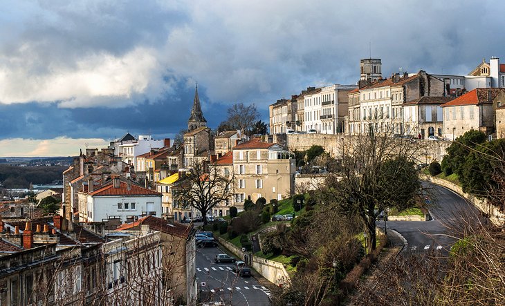
Stage 3: Périgueux > Aurillac - 190km - flat
https://www.la-flamme-rouge.eu/maps/viewtrack/hd/133507
FqCD5UI.png

8ArpvaR.png

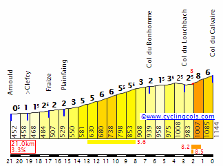
The second (presumed) sprint stage in a row, but this one is slightly trickier due to the inclusion of a 2nd category climb roughly 50km from the finish, the Côte de la Chapelle Saint Géraud. Besides this climb, we have several 4th category climbs that would usually be uncategorized, but we're in the first few stages of the Tour and the KOM hunters will want something to go for. After the Côte de la Chapelle Saint Géraud, the road goes up and down all the time. In the final 10km, we see some short ramps of 4-5%, while the final km is slightly downhill. The finishing straight is quite long, around 1km with one very slight bend, but there is some road furniture that the riders will have to avoid, or we can remove it before the race. ;)
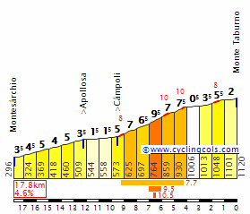
The climbs:
Côte de Atur (4th Category, 223 m, 5.1 Km at 2.6%, Km 6.3)
Côte du Planchat (4th Category, 326 m, 4.4 Km at 3.0%, Km 93.4)
Côte du Noual (4th Category, 264 m, 2.7 Km at 3.9%, Km 105.5)
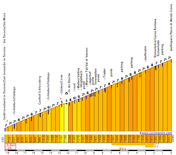
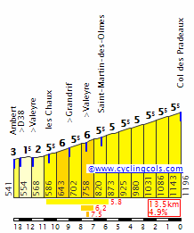
Côte de la Chapelle Saint Géraud (2nd Category, 558 m, 6.3 Km at 5.9%, Km 142.5)

PUHYsPK.png


bZqCWnQ.png

Profile of the 2nd category Côte de la Chapelle Saint Géraud

oUkXLAD.png

Start of the 2nd category climb

osOrU31.png

Wide roads and good tarmac on the Côte de la Chapelle Saint Géraud

prigueuxviueduciel.jpg

Starting city Périgueux
 
Re:

Forever The Best said:
Can you post the link if you use La Flammerouge? (Since Imgur is blocked in my country.)
Also, stage 3 can be classified as a medium mountain stage as well. A mixture of both flat and medium mountains.
I have just added the links :)
Don't cheat and look ahead though ;)
It's a bit difficult for me to classify the borderline flat/mm and borderline mm/hm stages, I try to be consistent at least but not sure I always am :D
 
Re:

LaFlorecita said:
I finally have my fantasy TDF ready to post as well. I have a stage start on the Le Mans circuit like bp92, but I am confident our races won't be too similar. I have a fantasy Giro as well, but with 2 Giri being posted I thought it was better to put that one back on the shelf for a while. :) As usual, I struggled with the sprint stages. I always like to put a few obstacles for the sprinters to get past like a hill just before the finish or a finish that goes up a few %, but somehow, this never works out for me when designing a Tour de France. It seems much easier in Italy or Spain.
Love the finish in Angoulême; I'd bring them up to the city from further round towards the station: much steeper, not one for pure sprinters.
 
Stage 4: Issoire > Villefranche-sur-Saône - 184km - medium mountains
https://www.la-flamme-rouge.eu/maps/viewtrack/hd/133517
iUzAIME.png

MhGvgn5.png

The race moves further east, from Issoire to Villefranche-sur-Saône. The first half of the stage is quite tough, with several categorized climbs. The 2nd category Col des Pradeaux is the main highlight of today's stage. It's not very steep but quite long and with the other climbs in this stage it should be possible to drop the worst climbers among the sprinters. There are still 100km from the summit of the last climb to the finish though, so some strong teams will have to drill it. The intermediate sprint is just after the descent of the Col des Limites, this should be extra incentive for teams of Sagan and Matthews types to make the first part of the stage very hard, even if other sprinters make it back to the peloton later. The final 5k are completely flat, with a 90 degree corner with 300m to go.

Climbs:
Col de Toutée (3rd Category, 991 m, 9.3 Km at 3.3%, Km 39.5)
Col des Fourches (3rd Category, 969 m, 2.8 Km at 6.3%, Km 46.8)
Col des Pradeaux (2nd Category, 1196 m, 13.1 Km at 5.0%, Km 71.6)
Col des Limites (3rd Category, 1156 m, 4.3 Km at 4.8%, Km 84.6)

TQ3gQTP.png


K5Hq6mI.png
PradeauxW.gif

Col des Pradeaux

V1Tfkks.png

Col des Limites

HqqQHhR.jpg

zKkin89.png

Great roads on the climbs and descents


Stage 5: Besançon > Côte du Gaschney - 192.5km - high mountains
https://www.la-flamme-rouge.eu/maps/viewtrack/hd/133529
lnNtKd0.png

IjMjPz2.png

xgiUzDV.png

The first real test for the GC contenders comes as we enter the Vosges. After the start in Besançon and 100km of more or less flat terrain, the peloton must tackle the first climb: the 1st category Ballon d'Alsace. From this side, it's rather long but not very steep, however it will tire the legs a bit for what comes next. The hardest climb of this stage is the long and irregular Col du Grand Ballon, from Moosch (Interactive Veloviewer profile of le Grand Ballon). A bit before the summit the riders will turn left onto a plateau and ride in the direction of Le Markstein and then the summit of the Col du Platzerwasel. Then, a long and technical descent and finally the finish on the 2nd category Côte de Gaschney. As far as I know, this climb hasn't been used before in the Tour, but I don't see why not, the road is in perfect condition and at the summit there is a large parking area. This climb is neither very long nor very steep so gaps won't be large, but it'll give an indication of the GC favorites' shape.

The climbs:
Ballon d'Alsace (1st Category, 1169 m, 14.7 Km at 4.5%, Km 115.8)
Col de Bussang (4th Category, 740 m, 3.2 Km at 4.4%, Km 133.5)
Le Grand Ballon (1st Category, 1222 m, 11.8 Km at 7.0%, Km 160.4)
Côte du Gaschney (2nd Category, 987 m, 7.6 Km at 6.8%, Arrive)

76CnqSG.png

Ballon d'Alsace

UT8XOsT.png
GrandBallonW.gif

Col du Grand Ballon

uu1J3WL.png
Gaschney.gif

Côte du Gaschney

nxACOLR.png

fnwrmdC.jpg

Ballon d'Alsace climb and descent

skHF06z.png

Le Grand Ballon climb

mgqXJkJ.png

TQI2yIg.jpg

Col du Platzerwasel descent

QgEhoJs.jpg

coof1R5.png

Côte du Gaschney climb and finish area

2261857_besancon-012.jpg

Starting city Besançon
 
About time someone uses Le Gaschney! And the lead up is really good too, with Ballon d'Alsace and Grand Ballon. I've also designed a stage finishing in Le Gaschney:
https://www.la-flamme-rouge.eu/maps/viewtrack/hd/108218
The climbs are, Ballon de Servance, Ballon d'Alsace, Hundsruck, Grand Ballon, Bramont, Schlucht, Collet du Linge, Platzerwasel, Le Gaschney.
The next stage can enter German territory with a stage finish in Feldberg, like this:
https://www.la-flamme-rouge.eu/maps/viewtrack/hd/108487

PS: There is a glitch on Grand Ballon on your stage.
 
Re:

Forever The Best said:
About time someone uses Le Gaschney! And the lead up is really good too, with Ballon d'Alsace and Grand Ballon. I've also designed a stage finishing in Le Gaschney:
https://www.la-flamme-rouge.eu/maps/viewtrack/hd/108218
The climbs are, Ballon de Servance, Ballon d'Alsace, Hundsruck, Grand Ballon, Bramont, Schlucht, Collet du Linge, Platzerwasel, Le Gaschney.
The next stage can enter German territory with a stage finish in Feldberg, like this:
https://www.la-flamme-rouge.eu/maps/viewtrack/hd/108487
I use Ballon de Servance in my next stage :) Col du Hundsruck is another climb I really like, but I normally use it from the other side. Lots of hard climbs in the Vosges that are hardly ever used.
PS: There is a glitch on Grand Ballon on your stage.
Yeah, I saw that and just assumed it was a tunnel :p
 
Re: Re:

LeakyBoat said:
LaFlorecita said:
I finally have my fantasy TDF ready to post as well. I have a stage start on the Le Mans circuit like bp92, but I am confident our races won't be too similar. I have a fantasy Giro as well, but with 2 Giri being posted I thought it was better to put that one back on the shelf for a while. :) As usual, I struggled with the sprint stages. I always like to put a few obstacles for the sprinters to get past like a hill just before the finish or a finish that goes up a few %, but somehow, this never works out for me when designing a Tour de France. It seems much easier in Italy or Spain.
Love the finish in Angoulême; I'd bring them up to the city from further round towards the station: much steeper, not one for pure sprinters.
Yeah, unfortunately it's about the only non-straightforward sprint finish in my race :redface:
 
Re: Re:

LaFlorecita said:
Forever The Best said:
About time someone uses Le Gaschney! And the lead up is really good too, with Ballon d'Alsace and Grand Ballon. I've also designed a stage finishing in Le Gaschney:
https://www.la-flamme-rouge.eu/maps/viewtrack/hd/108218
The climbs are, Ballon de Servance, Ballon d'Alsace, Hundsruck, Grand Ballon, Bramont, Schlucht, Collet du Linge, Platzerwasel, Le Gaschney.
The next stage can enter German territory with a stage finish in Feldberg, like this:
https://www.la-flamme-rouge.eu/maps/viewtrack/hd/108487
I use Ballon de Servance in my next stage :) Col du Hundsruck is another climb I really like, but I normally use it from the other side. Lots of hard climbs in the Vosges that are hardly ever used.
PS: There is a glitch on Grand Ballon on your stage.
Yeah, I saw that and just assumed it was a tunnel :p
Not tunnel, but, while climbing the Grand Ballon, it looks like you go to a dead-end random road for 300-500m, then come back to the road where you left off again.

And my stage is too hard for stage 5, it should be stage 14, 18 or 19. Your one is absolutely fine for stage 5.
Looking forward to rest of your TDF.
 
Stage 6: Saint-Dié-des-Vosges > Mulhouse - 185km - medium mountains
https://www.la-flamme-rouge.eu/maps/viewtrack/hd/133547
z7iI43C.png

M90Grvj.png


A second stage in the Vosges, this time not for the GC contenders but it's a great opportunity for stage hunters. The first part of the stage is very tough with several categorized climbs in quick succession, a strong breakaway will likely form in this part of the stage. However, the last part is flat so it could be a chance for the sprinters as well if their teams keep the break close. Right after the start, we have the Col de Mandray followed by the long but shallow Col du Calvaire. After a descent and a 10km long valley, we have the Col de Grosse Pierre - Col du Brabant duo. From Gérardmer, the Col de Grosse Pierre consists of an easy first part and a tougher second part, divided by a short downhill section. The Col du Brabant is short but steep: potentially the lesser climbers of the breakaway could be dropped here, but if not here, it could still happen on the Ballon de Servance. The average gradient of this climb (only 4.8%) doesn't look very impressive, but halfway through the climb there are a few (false) flat kilometers.

The climbs:
Col de Mandray (3rd Category, 690 m, 4.0 Km at 6.3%, Km 14.8)
Col du Calvaire (2nd Category, 1147 m, 14.4 Km at 4.0%, Km 31.9)
Col de Grosse Pierre (3rd Category, 953 m, 7.9 Km at 3.7%, Km 69.3)
Col du Brabant (2nd Category, 875 m, 2.9 Km at 8.5%, Km 78.4)
Ballon de Servance (2nd Category, 1150 m, 13.8 Km at 4.8%, Km 110.6)

kVhNS4c.png

Final 5km

MandrayW.gif

Col de Mandray

CalvaireNW.gif

Col du Calvaire

GrossePierreN.gif

Col de Grosse Pierre

rG7GZXf.png
BrabantN.gif

Col du Brabant

1YXmpqi.png

Ballon de Servance

X2dgW4F.png

cOrtzYI.png

Col du Brabant

rDq6w7m.png

Ballon de Servance, narrow roads

SfaHMjh.jpg

OWrW859.jpg

Descents of the Col du Brabant and Ballon de Servance are even narrower


Stage 7: Vesoul > Mâcon - 214.5km - flat
https://www.la-flamme-rouge.eu/maps/viewtrack/hd/133552
F2Ooe2G.png

nTuOFi0.png


This could very well be the first stage for the pure sprinters. Not much to say. Over 200km of flat roads, following the river Saône from Vesoul to Mâcon. The final is pretty straightforward, except for a roundabout in the final kilometer.

V9iag7p.png

Final kilometers are pan-flat

pont_saint_laurent_nuit_lightbox.jpg

Finishing city Mâcon
 

TRENDING THREADS