
Race Design Thread
Page 20 - Get up to date with the latest news, scores & standings from the Cycling News Community.
You are using an out of date browser. It may not display this or other websites correctly.
You should upgrade or use an alternative browser.
You should upgrade or use an alternative browser.


- Mar 24, 2011
- 10,527
- 1,927
- 25,680
STAGE 6 Messina - Etna 151 kms
Short stage, with a first climb to the Etna (northern side) before climbing the volcano again. This time, unlike they did this year, the riders won't stop at Rifugio Sapienza, but they'll continue all the way up to Torre Del Filosofo, at almost 2900 m above sea level, not far from the crater itself. The road after Rifugio Sapienza is steep and unpaved. This is by far the hardest climb in Italy, considering the altitude and the air full of ash.


Short stage, with a first climb to the Etna (northern side) before climbing the volcano again. This time, unlike they did this year, the riders won't stop at Rifugio Sapienza, but they'll continue all the way up to Torre Del Filosofo, at almost 2900 m above sea level, not far from the crater itself. The road after Rifugio Sapienza is steep and unpaved. This is by far the hardest climb in Italy, considering the altitude and the air full of ash.
- Mar 24, 2011
- 10,527
- 1,927
- 25,680
I'll post the second week later.
7 Firenze - Abetone 181 kms
8 Sestri Levante - Ottone 195 kms
9 Genova - S.Anna Di Vinadio 234 kms
10 Argentera - Sampeyre 222 kms
11 Sampeyre - Colle Del Sommeiller 198 kms
12 Oulx - La Thuile 193 kms
REST (Transfer to Bergamo)
7 Firenze - Abetone 181 kms
8 Sestri Levante - Ottone 195 kms
9 Genova - S.Anna Di Vinadio 234 kms
10 Argentera - Sampeyre 222 kms
11 Sampeyre - Colle Del Sommeiller 198 kms
12 Oulx - La Thuile 193 kms
REST (Transfer to Bergamo)
- Feb 20, 2010
- 33,269
- 15,819
- 28,180
After transferring across to San Luís, the péloton will be facing some roads more familiar to a European audience as we head towards the end of the race.
Stage 12: San Luís - Potrero de los Funes, 156km

After a short lead-in from San Luís, the riders face 4 circuits of a 30km loop including the category 2 climb of the Mirador del Potrero. On the fifth lap, they will ascend the Mirador, but instead of continuing across the semipermanent motor racing facility circling the lake at Potrero de los Funes, they will complete 2 laps of the racing circuit. The final climb of the Mirador crests at about 18km to the finish, so will provide a platform for an attack, whether it be for the GC battle or from the breakaway. For a bit more of the climb, see the last few minutes of this video, from the 2011 Tour de San Luís, where they used it as an MTF: http://www.youtube.com/watch?v=WFkXwEe-zIA - they started with several laps of the racing circuit at which my stage is finishing.
Here is an onboard video from the motor racing circuit, which we will be finishing at:
http://www.youtube.com/watch?v=n1GLyF3TUJM
Notice the rolling gradients, and in particular the section from 1:50 to 2:10. That's 600m at about 8% there, finishing less than 1,5km from the finishing line. This could make for an interesting culmination to the stage, either allowing a late escape from a small bunch selected by the climbs, or spelling the death of a solo or small group escapade at the last.

Climbs:
Mirador del Potrero (cat.2) 5,7km @ 6,1%
Mirador del Potrero (cat.2) 5,7km @ 6,1%
Mirador del Potrero (cat.2) 5,7km @ 6,1%
Mirador del Potrero (cat.2) 5,7km @ 6,1%
Mirador del Potrero (cat.2) 5,7km @ 6,1%
Potrero de los Funes (Autodromo)(cat.3) 600m @ 8,0%
Potrero de los Funes (Autodrome)(Cat.3) 600m @ 8,0%
San Luís:

Potrero de los Funes Circuit (finish on the left, climb section at bottom left):

Stage 12: San Luís - Potrero de los Funes, 156km
After a short lead-in from San Luís, the riders face 4 circuits of a 30km loop including the category 2 climb of the Mirador del Potrero. On the fifth lap, they will ascend the Mirador, but instead of continuing across the semipermanent motor racing facility circling the lake at Potrero de los Funes, they will complete 2 laps of the racing circuit. The final climb of the Mirador crests at about 18km to the finish, so will provide a platform for an attack, whether it be for the GC battle or from the breakaway. For a bit more of the climb, see the last few minutes of this video, from the 2011 Tour de San Luís, where they used it as an MTF: http://www.youtube.com/watch?v=WFkXwEe-zIA - they started with several laps of the racing circuit at which my stage is finishing.
Here is an onboard video from the motor racing circuit, which we will be finishing at:
http://www.youtube.com/watch?v=n1GLyF3TUJM
Notice the rolling gradients, and in particular the section from 1:50 to 2:10. That's 600m at about 8% there, finishing less than 1,5km from the finishing line. This could make for an interesting culmination to the stage, either allowing a late escape from a small bunch selected by the climbs, or spelling the death of a solo or small group escapade at the last.
Climbs:
Mirador del Potrero (cat.2) 5,7km @ 6,1%
Mirador del Potrero (cat.2) 5,7km @ 6,1%
Mirador del Potrero (cat.2) 5,7km @ 6,1%
Mirador del Potrero (cat.2) 5,7km @ 6,1%
Mirador del Potrero (cat.2) 5,7km @ 6,1%
Potrero de los Funes (Autodromo)(cat.3) 600m @ 8,0%
Potrero de los Funes (Autodrome)(Cat.3) 600m @ 8,0%
San Luís:
Potrero de los Funes Circuit (finish on the left, climb section at bottom left):
Libertine Seguros said:Stage 12: San Luís - Potrero de los Funes, 156km
I like loops, especially these type that have a solid climb included. Nice work.
- Feb 20, 2010
- 33,269
- 15,819
- 28,180
Now it is time for the climbers to have their final say in the Vuelta a la Argentina, with our last, and biggest, mountaintop finish, in our longest stage as well.
Stage 13: San Francisco del Monte de Oro - Sierra de los Comechingones (Filo Serrano), 229km

The climb up to the Mirador del Sol has always been one of the trademarks of the Tour de San Luís. This climb, from Villa de Merlo, ascends to a height of 1450m. Should you continue on this road, however, it continues to climb, and climb, and eventually reaches the Sierra de los Comechingones at a radio mast known affectionately as the Filo Serrano, or Filo de Merlo. This is some way further up the mountain, at 2056m.
In this long, drawn out stage, this is our destination. The riders start at the base of the climb of Cerro El Amago, often used in the Tour de San Luís ahead of a finish in La Carolina. From there, however, it's basically 190 flat kilometres on roads of varying quality before depositing the riders in Villa de Merlo, ready to face the race to the sky. The Mirador del Sol is passed about halfway up the final climb, after which the gradient lets up briefly, before finishing off with a few kilometres around the 8% mark. If they didn't take advantage of the Cerro San Javier or Portezuelo, the climbers will have to go now; but without multiple climbs to ward them off beforehand, how well will the rouleurs and time trial-minded GC men be able to handle the pace?

Climbs:
Cerro El Amago (cat.1) 13,0km @ 6,2%
Sierra de los Comechingones (cat.E) 18,4km @ 6,8%
After the stage it's a short transfer to the unusual city of Villa General Belgrano; more on that when we get to it.
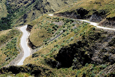
Looking down from Cerro El Amago on San Francisco del Monte de Oro:

Looking down from the Sierra de los Comechingones:

Stage 13: San Francisco del Monte de Oro - Sierra de los Comechingones (Filo Serrano), 229km
The climb up to the Mirador del Sol has always been one of the trademarks of the Tour de San Luís. This climb, from Villa de Merlo, ascends to a height of 1450m. Should you continue on this road, however, it continues to climb, and climb, and eventually reaches the Sierra de los Comechingones at a radio mast known affectionately as the Filo Serrano, or Filo de Merlo. This is some way further up the mountain, at 2056m.
In this long, drawn out stage, this is our destination. The riders start at the base of the climb of Cerro El Amago, often used in the Tour de San Luís ahead of a finish in La Carolina. From there, however, it's basically 190 flat kilometres on roads of varying quality before depositing the riders in Villa de Merlo, ready to face the race to the sky. The Mirador del Sol is passed about halfway up the final climb, after which the gradient lets up briefly, before finishing off with a few kilometres around the 8% mark. If they didn't take advantage of the Cerro San Javier or Portezuelo, the climbers will have to go now; but without multiple climbs to ward them off beforehand, how well will the rouleurs and time trial-minded GC men be able to handle the pace?
Climbs:
Cerro El Amago (cat.1) 13,0km @ 6,2%
Sierra de los Comechingones (cat.E) 18,4km @ 6,8%
After the stage it's a short transfer to the unusual city of Villa General Belgrano; more on that when we get to it.
Looking down from Cerro El Amago on San Francisco del Monte de Oro:
Looking down from the Sierra de los Comechingones:
- Feb 20, 2010
- 33,269
- 15,819
- 28,180


Climber's Tour of Victoria - Stage 2 Hurstbridge to Mount Baw Baw
Ok, stage 2 of the climber's Tour of Victoria, and we're going to get straight into it with a 170 km stage with several climbs and a brutal summit finish.
Map and profile here.
Major climbs: Kinglake 7.2km@4.8% cat 3 Description and profile here.
Vesper's Hill 2.9km at 9.1% cat 3
Mount Baw Baw 6.4km at 12.0% HC. Description & profile here
We start in Hurstbridge, something of a "tree-changer" town 50 km from central Melbourne. It's attractive enough in its own way, but rather lacking in architectural highlights. This was the best that I could do:

From here, we hit a warm-up climb almost immediately, the climb to Kinglake: 7.2km at 4.8 %. This is another favourite of Melbourne cyclists. The area was devastated in the "Black Saturday" bushfires of 2009, with 120 people dying throughout the region:
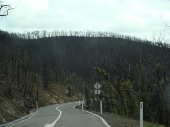 This photo of Kinglake is courtesy of TripAdvisor
While the trees have begun to regrow from the time the photo was taken, the natural and human environment bears scars will which take many years to heal.
From there, we roll through and gently descend along Chum Creek Road into Healesville, another lovely daytripper tourist town and home of Healesville Sanctury, a superb native animal zoo.
Unfortunately, the riders will not have a chance to dine at the wonderful Healesville Hotel, and continue on their way through Yarra Junction. A short distance to the east is another fine climb, Mount Donna Buang, but instead we turn south and towards Noojee. The massive wooden trestle bridgeisn't visible from the course, but is well worth a short detour if you're down the way. The burgers at the Red Parrot Cafe are also excellent, but not recommended given what's coming...
Coming out of Noojee, the fun really begins at about 40km to go, with the short but nasty pinch of Vesper's Hill (2.9 km at 9.1%). There's basically no level road from here to the finish - you're either climbing or descending.
After what will seem like an endless series of rolling hills, the final assault on the infamous Mount Baw Baw begins. The full climb is 12.27 kilometres as 7.9%, but its infamy comes from its final 6.43 kilometres starting from the old toll booth. The average gradient is 12%, and the road briefly peaks at 20% at "Winch corner". It is but a small mercy that the road surface is excellent, and the climb conducted almost entirely in the shade.
The view from the top at the small ski and mountain bike resort is gorgeous, but after the brutality of Baw Baw, it will be a while before the riders have any interest in looking.

Ok, stage 2 of the climber's Tour of Victoria, and we're going to get straight into it with a 170 km stage with several climbs and a brutal summit finish.
Map and profile here.
Major climbs: Kinglake 7.2km@4.8% cat 3 Description and profile here.
Vesper's Hill 2.9km at 9.1% cat 3
Mount Baw Baw 6.4km at 12.0% HC. Description & profile here
We start in Hurstbridge, something of a "tree-changer" town 50 km from central Melbourne. It's attractive enough in its own way, but rather lacking in architectural highlights. This was the best that I could do:
From here, we hit a warm-up climb almost immediately, the climb to Kinglake: 7.2km at 4.8 %. This is another favourite of Melbourne cyclists. The area was devastated in the "Black Saturday" bushfires of 2009, with 120 people dying throughout the region:
While the trees have begun to regrow from the time the photo was taken, the natural and human environment bears scars will which take many years to heal.
From there, we roll through and gently descend along Chum Creek Road into Healesville, another lovely daytripper tourist town and home of Healesville Sanctury, a superb native animal zoo.
Unfortunately, the riders will not have a chance to dine at the wonderful Healesville Hotel, and continue on their way through Yarra Junction. A short distance to the east is another fine climb, Mount Donna Buang, but instead we turn south and towards Noojee. The massive wooden trestle bridgeisn't visible from the course, but is well worth a short detour if you're down the way. The burgers at the Red Parrot Cafe are also excellent, but not recommended given what's coming...
Coming out of Noojee, the fun really begins at about 40km to go, with the short but nasty pinch of Vesper's Hill (2.9 km at 9.1%). There's basically no level road from here to the finish - you're either climbing or descending.
After what will seem like an endless series of rolling hills, the final assault on the infamous Mount Baw Baw begins. The full climb is 12.27 kilometres as 7.9%, but its infamy comes from its final 6.43 kilometres starting from the old toll booth. The average gradient is 12%, and the road briefly peaks at 20% at "Winch corner". It is but a small mercy that the road surface is excellent, and the climb conducted almost entirely in the shade.
The view from the top at the small ski and mountain bike resort is gorgeous, but after the brutality of Baw Baw, it will be a while before the riders have any interest in looking.
- Mar 24, 2011
- 10,527
- 1,927
- 25,680
STAGE 7 Firenze - Abetone 181 kms
after the starts in Florence, 2 easy climbs introduce another monster of the Appennines, S.Pellegrino In Alpe. After that, MTF to the classic (and much easier) climb of Abetone.

Piastre 9 kms @ 6.9%
Renaio 13.5 kms @ 6.5%
S.Pellegrino In Alpe 16.7 kms @ 7.5%
Abetone 12.1 kms @ 5.1%

after the starts in Florence, 2 easy climbs introduce another monster of the Appennines, S.Pellegrino In Alpe. After that, MTF to the classic (and much easier) climb of Abetone.
Piastre 9 kms @ 6.9%
Renaio 13.5 kms @ 6.5%
S.Pellegrino In Alpe 16.7 kms @ 7.5%
Abetone 12.1 kms @ 5.1%
- Mar 24, 2011
- 10,527
- 1,927
- 25,680
STAGE 8 Sestri - Ottone 195 kms
Tough multi-climbs stage between Liguria and Emilia. No super hard climbs but more than 5000m of altitude gain.

Bocco 15.3 kms @ 5.6%
Cento Croci 13.1 kms @ 5.2
Chiodo 11.4 kms @ 6.1%
Tomarlo 10 kms @ 6.7%
Crociglia 9.9 kms @ 8%
Mercatello 8.9 kms @ 4.8%
Lisore 6.7 kms @ 9.5%
Tough multi-climbs stage between Liguria and Emilia. No super hard climbs but more than 5000m of altitude gain.
Bocco 15.3 kms @ 5.6%
Cento Croci 13.1 kms @ 5.2
Chiodo 11.4 kms @ 6.1%
Tomarlo 10 kms @ 6.7%
Crociglia 9.9 kms @ 8%
Mercatello 8.9 kms @ 4.8%
Lisore 6.7 kms @ 9.5%


- Mar 24, 2011
- 10,527
- 1,927
- 25,680
STAGE 10 Argentera - Sampeyre 222 kms
A loop across the French border, through Bonette and Lombarde, then back again in Italy with Fauniera (the opposite side of the day before) and Sampeyre
first 135 kms

last 87 kms

Maddalena 6.8 kms @ 4.9%
Bonette 24 kms @ 6.6%
Lombarde 21.5 kms @ 6.9%
Fauniera 24.7 kms @ 7%
Sampeyre 16.2 kms @ 8.2%
A loop across the French border, through Bonette and Lombarde, then back again in Italy with Fauniera (the opposite side of the day before) and Sampeyre
first 135 kms
last 87 kms
Maddalena 6.8 kms @ 4.9%
Bonette 24 kms @ 6.6%
Lombarde 21.5 kms @ 6.9%
Fauniera 24.7 kms @ 7%
Sampeyre 16.2 kms @ 8.2%
Eshnar said:STAGE 8 Sestri - Ottone 195 kms
Tough multi-climbs stage between Liguria and Emilia. No super hard climbs but more than 5000m of altitude gain.
I really like this stage, would love to see it in a real GT
")
And what a beast the extended Etna stage is. Graet job so far and I believe you have prepared even better stages in Alps
- Mar 24, 2011
- 10,527
- 1,927
- 25,680
STAGE 11 Sampeyre - Colle Del Sommeiller 198 kms
MTF to the Cima Coppi of the Giro. It starts with the Agnello, then Izoard, Granon, Echelle and the final climb to the almost 3000m of Colle Del Sommeiller. The final part needs to be resurfaced though.

Agnello 22.4 kms @ 6.5%
Izoard 15.9 kms @ 6.9%
Granon 11.5 kms @ 9.2%
Echelle 17 kms @ 2.3%
Sommeiller 26.3 kms @ 6.5%

MTF to the Cima Coppi of the Giro. It starts with the Agnello, then Izoard, Granon, Echelle and the final climb to the almost 3000m of Colle Del Sommeiller. The final part needs to be resurfaced though.
Agnello 22.4 kms @ 6.5%
Izoard 15.9 kms @ 6.9%
Granon 11.5 kms @ 9.2%
Echelle 17 kms @ 2.3%
Sommeiller 26.3 kms @ 6.5%
- Mar 24, 2011
- 10,527
- 1,927
- 25,680
thanks. I really like that stage too because it runs through my regiontogo95 said:I really like this stage, would love to see it in a real GT
And what a beast the extended Etna stage is. Graet job so far and I believe you have prepared even better stages in Alps
And... be sure the Alps are better


- Mar 24, 2011
- 10,527
- 1,927
- 25,680
STAGE 13 Bergamo - Prato Maslino 170 kms
After the rest day, the Valcava is just a nice warmup before the real mountains start
First the colossal Passo San Marco, then the crazy climb to Prato Maslino

Valcava 11.8 kms @ 8%
San Marco 18.2 kms @ 7.9%
Prato Maslino 12.2 kms @ 11.3%

After the rest day, the Valcava is just a nice warmup before the real mountains start
First the colossal Passo San Marco, then the crazy climb to Prato Maslino
Valcava 11.8 kms @ 8%
San Marco 18.2 kms @ 7.9%
Prato Maslino 12.2 kms @ 11.3%
- Jan 27, 2011
- 3,399
- 0
- 0
- Mar 24, 2011
- 10,527
- 1,927
- 25,680

- Mar 24, 2011
- 10,527
- 1,927
- 25,680
STAGE 15 Bormio - Pra Campo 211 kms
Hellish stage, with Mortirolo (from Grosio), Gavia, Mortirolo again (this time from Mazzo), Monte Padrio and the unused climb to Pra Campo
Last 193 kms

Mortirolo (Grosio) 14.8 kms @ 8.3%
Gavia 17.3 kms @ 7.9%
Mortirolo (Mazzo) 12.4 kms @ 10.5%
Padrio 9.4 kms @ 9.8%
Pra Campo 13.5 kms @ 9.7%

Hellish stage, with Mortirolo (from Grosio), Gavia, Mortirolo again (this time from Mazzo), Monte Padrio and the unused climb to Pra Campo
Last 193 kms
Mortirolo (Grosio) 14.8 kms @ 8.3%
Gavia 17.3 kms @ 7.9%
Mortirolo (Mazzo) 12.4 kms @ 10.5%
Padrio 9.4 kms @ 9.8%
Pra Campo 13.5 kms @ 9.7%
TRENDING THREADS
-
 Liège - Bastogne - Liège 2026, one-day monument, 26th April
- Started by Krzysztof_O
- Replies: 2K
-
 Paris-Roubaix 2026, one day monument, April 12
- Started by Lequack
- Replies: 2K
-
 Itzulia Basque Country 2026, April 6-11
- Started by Dazed and Confused
- Replies: 2K
-
 Ronde van Vlaanderen 2026, monument, April 5 (men's)
- Started by Krzysztof_O
- Replies: 1K
-
 Teams & Riders The Remco Evenepoel is the next Eddy Merckx thread
- Started by DNP-Old
- Replies: 40K
-
 Teams & Riders Tadej Pogačar discussion thread
- Started by Lequack
- Replies: 44K
-

Latest posts
-

-
New Jerseys - 2026 Season - TeamKits-Maillots-Tricots-Tenues
- Latest: Samu Cuenca
-
Teams & Riders The Remco Evenepoel is the next Eddy Merckx thread
- Latest: Rechtschreibfehler
-

Cyclingnews is part of Future plc, an international media group and leading digital publisher. Visit our corporate site.
© Future Publishing Limited Quay House, The Ambury, Bath BA1 1UA. All rights reserved. England and Wales company registration number 2008885.