
Race Design Thread
Page 29 - Get up to date with the latest news, scores & standings from the Cycling News Community.
You are using an out of date browser. It may not display this or other websites correctly.
You should upgrade or use an alternative browser.
You should upgrade or use an alternative browser.
- Feb 20, 2010
- 33,256
- 15,790
- 28,180
The Vuelta now takes us into País Vasco, for an intermediate stage, but one that could well have major GC implications.
Stage 18: Logroño - Zarautz, 204km

On first glance, you could say that this is about as easy a stage through the Basque country as you could achieve; after a short run out of the capital of La Rioja and a brief detour into Navarre, we spend a lot of time on the high plains of Araba, and bizarrely for a 200km stage mostly through the Basque country, there are only three categorised climbs for the day, one of which is incredibly easy, with much of the time once we descend into Gipuzkoa being along coastal roads, though there is some anger for the riders to face in the tougher side of the Collado Elosua; they rode the opposite side in the Vuelta this year, but 7,3km @ 7,5% of ever-changing gradients is not fun. Luckily for the riders there is plenty of time to recoup their energy before crossing the finishing line for the first time.
But all is not easy for the riders, however. They still have a bit of a circuit to do before they can rest up, and you might notice that that closing circuit has a climb in it, and that that climb crests a mere 10km from the finishing line. That climb, my friends, is THIS. That's right, Spain's answer to Montelupone, the possibly even more evil Alto de Aia, which after two and a half weeks of brutal racing around the Iberian peninsular will feel even more deadly than it does after four days, when riders who have reached the podium of Grand Tours have been forced to get off and walk - Bernhard Kohl in 2008 and David Arroyo in 2010 have both felt the shame of giving up on riding the 1400m of hell. Gaps can be opened up here for sure, and though the relatively short descent back into the beautiful Basque coastal town of Zarautz will undoubtedly allow some of the riders to reconvene in groups, a tight race could see some serious racing going on and some very small heads of state groups when they get back to the coast.
Watch the péloton tackle the beast in 2008 HERE. A few images that look like they should be accompanied by Carl Orff's "O Fortuna" from Carl Orff's Carmina Burana here, here, here and especially here... (warning for ACF: one of these photos has Alejandro Valverde in it)

Climbs:
Azazeta Mendatea (cat.3) 6,2km @ 3,5%
Collado Elosua (cat.1) 7,3km @ 7,5%
Alto de Aia (cat.2) 1,4km @ 14,4%
Logroño:

Zarautz:

Stage 18: Logroño - Zarautz, 204km
On first glance, you could say that this is about as easy a stage through the Basque country as you could achieve; after a short run out of the capital of La Rioja and a brief detour into Navarre, we spend a lot of time on the high plains of Araba, and bizarrely for a 200km stage mostly through the Basque country, there are only three categorised climbs for the day, one of which is incredibly easy, with much of the time once we descend into Gipuzkoa being along coastal roads, though there is some anger for the riders to face in the tougher side of the Collado Elosua; they rode the opposite side in the Vuelta this year, but 7,3km @ 7,5% of ever-changing gradients is not fun. Luckily for the riders there is plenty of time to recoup their energy before crossing the finishing line for the first time.
But all is not easy for the riders, however. They still have a bit of a circuit to do before they can rest up, and you might notice that that closing circuit has a climb in it, and that that climb crests a mere 10km from the finishing line. That climb, my friends, is THIS. That's right, Spain's answer to Montelupone, the possibly even more evil Alto de Aia, which after two and a half weeks of brutal racing around the Iberian peninsular will feel even more deadly than it does after four days, when riders who have reached the podium of Grand Tours have been forced to get off and walk - Bernhard Kohl in 2008 and David Arroyo in 2010 have both felt the shame of giving up on riding the 1400m of hell. Gaps can be opened up here for sure, and though the relatively short descent back into the beautiful Basque coastal town of Zarautz will undoubtedly allow some of the riders to reconvene in groups, a tight race could see some serious racing going on and some very small heads of state groups when they get back to the coast.
Watch the péloton tackle the beast in 2008 HERE. A few images that look like they should be accompanied by Carl Orff's "O Fortuna" from Carl Orff's Carmina Burana here, here, here and especially here... (warning for ACF: one of these photos has Alejandro Valverde in it)
Climbs:
Azazeta Mendatea (cat.3) 6,2km @ 3,5%
Collado Elosua (cat.1) 7,3km @ 7,5%
Alto de Aia (cat.2) 1,4km @ 14,4%
Logroño:
Zarautz:
- Feb 20, 2010
- 33,256
- 15,790
- 28,180
As we run back almost parallel to yesterday's route, it's time for the final opportunity for the climbers to make their time up in the Vuelta Libertina.
Stage 19: Donostia-San Sebastián - Sierra de San Miguel de Áralar, 164km

Our fourth mountaintop finish crowns the 19th stage, a much more typically Basque affair than its predecessor (even despite finishing in Navarre, and please let's not get into the ownership of Navarre/Nafarroa debate again), with no fewer than five categorised climbs preceding the epic finale.
We start in San Sebastián, a very Basque city that is nevertheless tied in to the history of the Vuelta a España, having hosted several race finishes in the 1970s prior to the long period of País Vasco being avoided by the race, and indeed cycling in general. The riders start climbing more or less as soon as they leave the port, climbing the Jaizkibel from the opposite side to that faced in the Clásica San Sebastián, and then following this immediately with the Castillo del Inglés climb; this climb varies wildly in estimates mainly because the actual summit is after a period of flat, but the main body of the climb is a steep 5km section.
After this initial loop, the riders will face a period of flat until the city of Tolosa, before the climbs start again in earnest, with two in quick succession in the terrain of another mid-season Basque one-day classic, the Klasika Ordizia. After this it is time for the gradual ascent of Lizarrusti, which will bring us up onto the higher plains as we cross from Gipuzkoa into Navarre, where the riders will spend 15km of flat until depositing riders at the base of the final climb, the epic San Miguel de Áralar. This is 11km at more than 8%, much of it on those same rough, unforgiving concrete roads as you saw on Bola del Mundo. The maximum gradient is 17% at the very top; though the climb never has any truly brutal sections, it is continually tough, with several kilometres at over 9%, a handful of stretches of 15% or so, and the climbers will need to make these 11km count, since this is the final roll of the dice.

Climbs:
Jaizkibel (cat.2) 8,0km @ 5,6%
Castillo del Inglés (cat.2) 5,0km @ 8,3%
Alto de Urdanpilleta (cat.1) 9,2km @ 6,4%
Alto Mandubia (cat.3) 5,7km @ 4,8%
Puerto de Lizarrusti (cat.3) 6,0km @ 5,4%
San Miguel de Áralar (MTF) 11,2km @ 8,1%
If you follow cycling, you don't really need a picture to tell you what San Sebastián looks like but here's one anyway:

San Miguel de Áralar:

More, if you want it, here, here, here and here...
Stage 19: Donostia-San Sebastián - Sierra de San Miguel de Áralar, 164km
Our fourth mountaintop finish crowns the 19th stage, a much more typically Basque affair than its predecessor (even despite finishing in Navarre, and please let's not get into the ownership of Navarre/Nafarroa debate again), with no fewer than five categorised climbs preceding the epic finale.
We start in San Sebastián, a very Basque city that is nevertheless tied in to the history of the Vuelta a España, having hosted several race finishes in the 1970s prior to the long period of País Vasco being avoided by the race, and indeed cycling in general. The riders start climbing more or less as soon as they leave the port, climbing the Jaizkibel from the opposite side to that faced in the Clásica San Sebastián, and then following this immediately with the Castillo del Inglés climb; this climb varies wildly in estimates mainly because the actual summit is after a period of flat, but the main body of the climb is a steep 5km section.
After this initial loop, the riders will face a period of flat until the city of Tolosa, before the climbs start again in earnest, with two in quick succession in the terrain of another mid-season Basque one-day classic, the Klasika Ordizia. After this it is time for the gradual ascent of Lizarrusti, which will bring us up onto the higher plains as we cross from Gipuzkoa into Navarre, where the riders will spend 15km of flat until depositing riders at the base of the final climb, the epic San Miguel de Áralar. This is 11km at more than 8%, much of it on those same rough, unforgiving concrete roads as you saw on Bola del Mundo. The maximum gradient is 17% at the very top; though the climb never has any truly brutal sections, it is continually tough, with several kilometres at over 9%, a handful of stretches of 15% or so, and the climbers will need to make these 11km count, since this is the final roll of the dice.
Climbs:
Jaizkibel (cat.2) 8,0km @ 5,6%
Castillo del Inglés (cat.2) 5,0km @ 8,3%
Alto de Urdanpilleta (cat.1) 9,2km @ 6,4%
Alto Mandubia (cat.3) 5,7km @ 4,8%
Puerto de Lizarrusti (cat.3) 6,0km @ 5,4%
San Miguel de Áralar (MTF) 11,2km @ 8,1%
If you follow cycling, you don't really need a picture to tell you what San Sebastián looks like but here's one anyway:
San Miguel de Áralar:
More, if you want it, here, here, here and here...
craig1985 said:Well done Kvinto on your tour, looks like a good race and with plenty of opportunities for attacking riding.
thanks Craig!
now (as i said that my race is like a train that changes its direction between the end stations) it's the matter of honour for me to develop the idea and create the route back home "Chernivtsi - L'viv Tour"
")
- Jan 27, 2011
- 3,399
- 0
- 0
Libertine Seguros said:
Libertine, you are a horrid and cruel person.
- May 6, 2009
- 8,522
- 1
- 0
I'm having a go at the Volta a Catalunya, I've done a prolouge and a road stage with a an uphill finish, but I'm researching good climbs to include, some that have been used and haven't used, although I do intend to use the Rat Penat at some point. I've started in Barcelona, started to go up the Costa Brava and that's about it. I won't go Andorra like they have in the past, but I'm thinking going west, then south for a bit and finishing again in Barcelona.
Suggestions?
Suggestions?
- Feb 20, 2010
- 33,256
- 15,790
- 28,180
There's only one thing for it... Jazz Odyssey!
No, not really.
There's only one thing for it... Coll de Pal MTF!!!
By the way, you'll see when I finish up my Vuelta and start on the next race that we have similar, but not quite the same, wavelengths.
No, not really.
There's only one thing for it... Coll de Pal MTF!!!
By the way, you'll see when I finish up my Vuelta and start on the next race that we have similar, but not quite the same, wavelengths.
- Feb 20, 2010
- 33,256
- 15,790
- 28,180
The final stage for the GC battle...
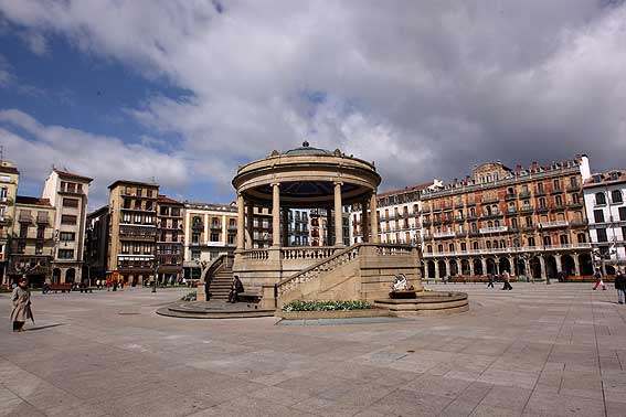
Stage 20: Pamplona - Pamplona (ITT), 31,0km

Starting and finishing in the beautiful square of Plaza del Castillo, the famous bull city and capital of Navarre has the pleasure of hosting the closing time trial, after which the riders will transfer back toward the capital for the clinking of champagne glasses and the celebrations of victory and agonies of defeat. But first, this medium-length time trial will answer any questions that remain to be answered.
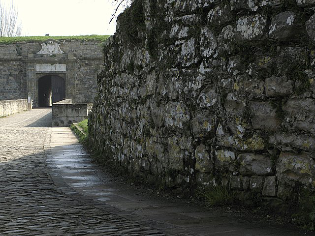
After leaving Plaza del Castillo, the riders take a brief loop on wide, open roads down towards the Ciudadela, and around some of Pamplona's famous sights, such as the Plaza del Toros and Frontón Labrit. A long period of multiple out-and-back portions around the northern perimeter of the city ensues, with only a short uphill drag of no more than 2,5% to break the rhythm of the flat power testers. The riders will take on all of the 6km northern stretch of the Ronda de Pamplona, and they will handle most of it in the other direction too, but interrupted by a technical section with several corners and roundabouts as they head down to the riverside and back. When the riders return to the riverside they will be faced with a short cobbled climb up to the city walls; though the section from the river to the finish is a general shallow uphill drag at a little over 2%, the specific 3-400m stretch can get quite steep before they handle the narrow cobbled streets of the final few hundred metres back into Plaza del Castillo.
You could, and perhaps should, argue that with four MTFs, more than a 30km ITT should be required in order to balance the route out, and this is a possible criticism of my route for sure. But I have included a 55km+ ITT, there is more than 90km against the clock in total, and I feel that since the Vuelta's organisers want the climbers to the fore, this is more how they should go about it than the way they have been.

No categorised climbs.
Plaza del Castillo, with Ernest Hemingway's beloved Café Iruña in the background:
Cobbled road to the city walls:
Stage 20: Pamplona - Pamplona (ITT), 31,0km
Starting and finishing in the beautiful square of Plaza del Castillo, the famous bull city and capital of Navarre has the pleasure of hosting the closing time trial, after which the riders will transfer back toward the capital for the clinking of champagne glasses and the celebrations of victory and agonies of defeat. But first, this medium-length time trial will answer any questions that remain to be answered.
After leaving Plaza del Castillo, the riders take a brief loop on wide, open roads down towards the Ciudadela, and around some of Pamplona's famous sights, such as the Plaza del Toros and Frontón Labrit. A long period of multiple out-and-back portions around the northern perimeter of the city ensues, with only a short uphill drag of no more than 2,5% to break the rhythm of the flat power testers. The riders will take on all of the 6km northern stretch of the Ronda de Pamplona, and they will handle most of it in the other direction too, but interrupted by a technical section with several corners and roundabouts as they head down to the riverside and back. When the riders return to the riverside they will be faced with a short cobbled climb up to the city walls; though the section from the river to the finish is a general shallow uphill drag at a little over 2%, the specific 3-400m stretch can get quite steep before they handle the narrow cobbled streets of the final few hundred metres back into Plaza del Castillo.
You could, and perhaps should, argue that with four MTFs, more than a 30km ITT should be required in order to balance the route out, and this is a possible criticism of my route for sure. But I have included a 55km+ ITT, there is more than 90km against the clock in total, and I feel that since the Vuelta's organisers want the climbers to the fore, this is more how they should go about it than the way they have been.
No categorised climbs.
Plaza del Castillo, with Ernest Hemingway's beloved Café Iruña in the background:
Cobbled road to the city walls:
- May 15, 2011
- 45,171
- 617
- 24,680
Could someone please explain to me how you all make those routes with the profiles? Because I'd love to have a go at it as well, I just don't know how...
- Feb 20, 2010
- 33,256
- 15,790
- 28,180
I use mapmyride.com. It has its flaws, but so do all of these things.
I tend to map my route out on there (manually if need be - some roads and passes that don't appear as roads on google maps - such as Anglirú, Peña Cabarga and the Muro di Montelupone - need to be entered this way), then get captures of the route and profile and post them up here.
Because the longer the route gets the more widespread the marker dots, hence the less accurate the climb data, I will recourse to a climbs database like altimetrias.net or climbbybike for more accurate info, or map the climb itself individually on mapmyride to get a more accurate representation if those do not have data available on the climb in question.
Others have different programs they like to use, like gpsies, tracks4bikers and so on, so it's a matter of tinkering around until you find one you're comfortable with.
- Feb 20, 2010
- 33,256
- 15,790
- 28,180
Right, all told, time for the parade.
Stage 21: Alcalá de Henares - Madrid, 96km

Do you need a profile or description for this one? This is the ceremonial finish which will be little more than a parade for the rider wearing the maillot rojo for the first half before several laps of the usual circuit finishing on the Paseo del Prado. This will inevitably be a sprint, and the race can be consigned to the history books, hopefully having been one of the more entertaining Vueltas of recent times.
Alcalá de Henares:

Madrid (Paseo del Prado):
Stage 21: Alcalá de Henares - Madrid, 96km
Do you need a profile or description for this one? This is the ceremonial finish which will be little more than a parade for the rider wearing the maillot rojo for the first half before several laps of the usual circuit finishing on the Paseo del Prado. This will inevitably be a sprint, and the race can be consigned to the history books, hopefully having been one of the more entertaining Vueltas of recent times.
Alcalá de Henares:
Madrid (Paseo del Prado):
- May 15, 2011
- 45,171
- 617
- 24,680
Libertine Seguros said:I use mapmyride.com. It has its flaws, but so do all of these things.
I tend to map my route out on there (manually if need be - some roads and passes that don't appear as roads on google maps - such as Anglirú, Peña Cabarga and the Muro di Montelupone - need to be entered this way), then get captures of the route and profile and post them up here.
Because the longer the route gets the more widespread the marker dots, hence the less accurate the climb data, I will recourse to a climbs database like altimetrias.net or climbbybike for more accurate info, or map the climb itself individually on mapmyride to get a more accurate representation if those do not have data available on the climb in question.
Others have different programs they like to use, like gpsies, tracks4bikers and so on, so it's a matter of tinkering around until you find one you're comfortable with.
Thank you!!
- Jun 16, 2009
- 19,654
- 2
- 0
Libertine Seguros said:
Yes I know. It is one of him by himself. Clearly zigzagging up the climb because he has put on so much weight while suspended.
- Feb 20, 2010
- 33,256
- 15,790
- 28,180
auscyclefan94 said:Yes I know. It is one of him by himself. Clearly zigzagging up the climb because he has put on so much weight while suspended.
As that video showed, the only riders capable of riding up that thing without any level of zigzagging were Joaquím Rodríguez and Alberto Contador. And besides, given Evans' climbing style out of the saddle appears to be based on trying to see if he can get the drops to touch the road without falling over, I wouldn't be too critical of others zigzagging
- May 6, 2009
- 8,522
- 1
- 0
Hey Libertine, you should have a go at the ENECO Tour
Here is my Volta a Catalunya.
Volta a Catalunya - Barcelona prolouge - 7.5km:
Map and profile
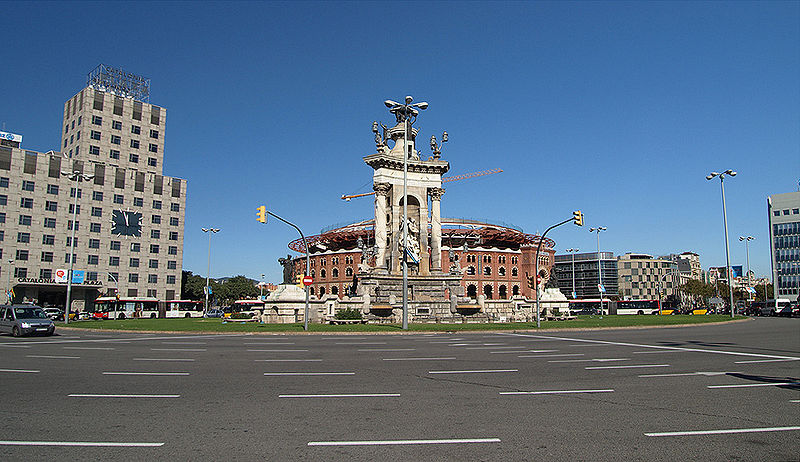
In a way to try to attract more publicity for the race and if the La Liga draw was kind enough, ideally the race would start on the day of El derbi barceloní between Barcelona and their cross-town rivals Espanyol so it's no surprise that the start will be from outside the Estadio Camp Nou and take in sights like the Plaça d'Espanya before heading towards the Estadi Olímpic Lluís Companys, home of Espanyol in Montjuïc.


Here is my Volta a Catalunya.
Volta a Catalunya - Barcelona prolouge - 7.5km:
Map and profile
In a way to try to attract more publicity for the race and if the La Liga draw was kind enough, ideally the race would start on the day of El derbi barceloní between Barcelona and their cross-town rivals Espanyol so it's no surprise that the start will be from outside the Estadio Camp Nou and take in sights like the Plaça d'Espanya before heading towards the Estadi Olímpic Lluís Companys, home of Espanyol in Montjuïc.
- Sep 8, 2010
- 1,441
- 0
- 0
Tour of Japan || Stage 13: Nagano - Takayama Village, 138 km

The second weekend starts with a short, but brutal stage around the west of Nagano. First we head on a little loop south, only to collect some kilometers of climbing and to bring a group together. After 60k, the stage really starts with two really heavy climbs. Kasagadake will make this day hard, but Kenashi Pass offers the possibility to attack hard. The finale of the day is characterized by another descent. This time of 22 kilometers. Last time for great descenders to bring back time for this weekend, because two mtf are waiting for the peloton.

Climbs
Cat. 1 // Route 34 (1257m), 11,8k @ 7.6%.
Cat. 1 // Mt.Kasagadake (1855m), 25k @ 5,7%
Cat. HC // Kenashi Pass (1910m), 14,6 km @ 8%
Kenashi Pass

Takayama Village

The second weekend starts with a short, but brutal stage around the west of Nagano. First we head on a little loop south, only to collect some kilometers of climbing and to bring a group together. After 60k, the stage really starts with two really heavy climbs. Kasagadake will make this day hard, but Kenashi Pass offers the possibility to attack hard. The finale of the day is characterized by another descent. This time of 22 kilometers. Last time for great descenders to bring back time for this weekend, because two mtf are waiting for the peloton.
Climbs
Cat. 1 // Route 34 (1257m), 11,8k @ 7.6%.
Cat. 1 // Mt.Kasagadake (1855m), 25k @ 5,7%
Cat. HC // Kenashi Pass (1910m), 14,6 km @ 8%
Kenashi Pass
Takayama Village
- Feb 20, 2010
- 33,256
- 15,790
- 28,180
Japan would be more or less the ideal place for a fourth Grand Tour. It's the right size to allow variety year on year without being too big that they can't feasibly cover it (i.e. it isn't Portugal, but it isn't the USA either), the terrain is varied, enabling the use of several distinct groups of mountains, the infrastructure is good enabling the hosting of a high profile race to be realistic, and the roads are good.
On another note, I'm moving on yet again. As you may have recalled, I mentioned to Craig when he said he was working on a Volta a Catalunya that we were on similar wavelengths. Well, here you go. Right at the very start of this thread I posted up a short stage race through the French part of the Basque country. It allowed a variety of stages, and the use of some difficult, interesting climbs that the Tour de France simply never uses because of its love of being really, really repetitive. So what about that other side of the Pyrenées, the OTHER part that isn't used? Well, just as the Iparraldeko Itzulia sought to give the French Basques their race, I have something for those on the other side, the French side of those other French-Spanish border people, and the area around their biggest French city. Allow me to present the Volta dels Pirineus Orientals, or Tour des Pyrénées-Orientales, utilising the French-Catalan terrain.
This will be another short stage race, like those typical of the Spanish calendar (and of my postings), using the Pyrénées-Orientales section of Languedoc-Roussillon as its base.
Stage 1: Perpinyà - Canet de Rossellò, 154km

We start with a fairly short and straightforward stage, looping around the capital and main city of the region, using some of the land to the north, before finishing by the Mediterranean sea in the pretty seaside town of Canet de Rossellò (Canet-en-Roussillon).
The first half of this stage is quite hilly and rolling, though none of the climbs are especially steep. Three climbs are categorised in the stage, but are unlikely to be decisive, and are more likely to feature a bit of competition between breakaway companions on smaller teams eager for a day in a jersey and the money that comes with it, before the race gets to its business end. The final 45km of the stage are absolutely pancake flat, and feature 2 laps of a 10km circuit before the race finishes on the third passage of the finishing line. There are a couple of corners on the run-in but this should be a sprint. There could be a bit of a sting in the tail if the wind blows, however - this is similar terrain to that which strung out the péloton back in stage 3 of the 2009 Tour, and if there is wind, then expect that there may be some echelon action in the closing stages, especially with us looping around our exposed seafront finale a couple of times.

Climbs:
Bèl Estar (cat.3) 8,2km @ 3,1%
Col des Auzines (cat.3) 6,5km @ 3,0%
Sarradas (cat.3) 6,5km @ 3,3%
Perpinyà:

Canet de Rossellò:

On another note, I'm moving on yet again. As you may have recalled, I mentioned to Craig when he said he was working on a Volta a Catalunya that we were on similar wavelengths. Well, here you go. Right at the very start of this thread I posted up a short stage race through the French part of the Basque country. It allowed a variety of stages, and the use of some difficult, interesting climbs that the Tour de France simply never uses because of its love of being really, really repetitive. So what about that other side of the Pyrenées, the OTHER part that isn't used? Well, just as the Iparraldeko Itzulia sought to give the French Basques their race, I have something for those on the other side, the French side of those other French-Spanish border people, and the area around their biggest French city. Allow me to present the Volta dels Pirineus Orientals, or Tour des Pyrénées-Orientales, utilising the French-Catalan terrain.
This will be another short stage race, like those typical of the Spanish calendar (and of my postings), using the Pyrénées-Orientales section of Languedoc-Roussillon as its base.
Stage 1: Perpinyà - Canet de Rossellò, 154km
We start with a fairly short and straightforward stage, looping around the capital and main city of the region, using some of the land to the north, before finishing by the Mediterranean sea in the pretty seaside town of Canet de Rossellò (Canet-en-Roussillon).
The first half of this stage is quite hilly and rolling, though none of the climbs are especially steep. Three climbs are categorised in the stage, but are unlikely to be decisive, and are more likely to feature a bit of competition between breakaway companions on smaller teams eager for a day in a jersey and the money that comes with it, before the race gets to its business end. The final 45km of the stage are absolutely pancake flat, and feature 2 laps of a 10km circuit before the race finishes on the third passage of the finishing line. There are a couple of corners on the run-in but this should be a sprint. There could be a bit of a sting in the tail if the wind blows, however - this is similar terrain to that which strung out the péloton back in stage 3 of the 2009 Tour, and if there is wind, then expect that there may be some echelon action in the closing stages, especially with us looping around our exposed seafront finale a couple of times.
Climbs:
Bèl Estar (cat.3) 8,2km @ 3,1%
Col des Auzines (cat.3) 6,5km @ 3,0%
Sarradas (cat.3) 6,5km @ 3,3%
Perpinyà:
Canet de Rossellò:
- Sep 8, 2010
- 1,441
- 0
- 0
Tour of Japan || Stage 14: Ueda - Mt.Mizugaki, 183 km

Ueda is situated in the east of the Nagano prefecture right in the mountains of the Japanese Alps. From here the race is heading south, easy beginning. The second part of this stage features some serious climbing with three Cat. 1 climbs and a mountain top finish in the border region of the Nagano and Yamanashi prefectures.

Climbs
Cat. 3 // Route 423 (816m), 7,2k @ 3.9%.
Cat. 3 // Route 141 (1381m), 10k @ 3.3%.
Cat. 2 // Shisenkyo Line (1107m), 8,4 km @ 4.0%.
Cat. 1 // Maiden Lake (1600m), 9,7k @ 5.8%.
Cat. 1 // Mt.Kokushigatake (2333m), 14,5k @ 6%.
Cat. 1 // Mt.Mizugaki (1905m), 9,4k @ 6.8%.
Ueda

Mt.Kokushigatake

Ueda is situated in the east of the Nagano prefecture right in the mountains of the Japanese Alps. From here the race is heading south, easy beginning. The second part of this stage features some serious climbing with three Cat. 1 climbs and a mountain top finish in the border region of the Nagano and Yamanashi prefectures.
Climbs
Cat. 3 // Route 423 (816m), 7,2k @ 3.9%.
Cat. 3 // Route 141 (1381m), 10k @ 3.3%.
Cat. 2 // Shisenkyo Line (1107m), 8,4 km @ 4.0%.
Cat. 1 // Maiden Lake (1600m), 9,7k @ 5.8%.
Cat. 1 // Mt.Kokushigatake (2333m), 14,5k @ 6%.
Cat. 1 // Mt.Mizugaki (1905m), 9,4k @ 6.8%.
Ueda
Mt.Kokushigatake
- Sep 8, 2010
- 1,441
- 0
- 0
Tour of Japan || Stage 15: Chichibu - Lake Onuma, 157 km

After a short transfer into the Saitama prefecture, the race will go on with another mountain stage. The last one before the second rest day. We are leaving a mountaineous region, crossing a very high populated area 100k north of Tokyo. After 70 kilometers the climbing with one and a half loops around the mountain lake Onuma begins. The climb is divided into two parts and we are climbing the Akagi volcano.

Climbs
Cat. 2 // Akagi (849m), 8,2k @ 4.8%.
Cat. 1 // Akagi Onuma Lake (1400m), 11,7k @ 6.9%.
Cat. 2 // Akagi (849m), 8,2k @ 4.8%.
Cat. 1 // Akagi Onuma Lake (1400m), 11,7k @ 6.9%.
Chichibu

Lake Onuma

After a short transfer into the Saitama prefecture, the race will go on with another mountain stage. The last one before the second rest day. We are leaving a mountaineous region, crossing a very high populated area 100k north of Tokyo. After 70 kilometers the climbing with one and a half loops around the mountain lake Onuma begins. The climb is divided into two parts and we are climbing the Akagi volcano.
Climbs
Cat. 2 // Akagi (849m), 8,2k @ 4.8%.
Cat. 1 // Akagi Onuma Lake (1400m), 11,7k @ 6.9%.
Cat. 2 // Akagi (849m), 8,2k @ 4.8%.
Cat. 1 // Akagi Onuma Lake (1400m), 11,7k @ 6.9%.
Chichibu
Lake Onuma
- May 6, 2009
- 8,522
- 1
- 0
Lupetto said:Tour of Japan || Stage 14: Ueda - Mt.Mizugaki, 183 km
Ueda is situated in the east of the Nagano prefecture right in the mountains of the Japanese Alps. From here the race is heading south, easy beginning. The second part of this stage features some serious climbing with three Cat. 1 climbs and a mountain top finish in the border region of the Nagano and Yamanashi prefectures.
Climbs
Cat. 3 // Route 423 (816m), 7,2k @ 3.9%.
Cat. 3 // Route 141 (1381m), 10k @ 3.3%.
Cat. 2 // Shisenkyo Line (1107m), 8,4 km @ 4.0%.
Cat. 1 // Maiden Lake (1600m), 9,7k @ 5.8%.
Cat. 1 // Mt.Kokushigatake (2333m), 14,5k @ 6%.
Cat. 1 // Mt.Mizugaki (1905m), 9,4k @ 6.8%.
Ueda
Mt.Kokushigatake
Is this your Queen stage?
TRENDING THREADS
-
 Paris-Roubaix 2026, one day monument, April 12
- Started by Lequack
- Replies: 2K
-
 Itzulia Basque Country 2026, April 6-11
- Started by Dazed and Confused
- Replies: 2K
-
 Ronde van Vlaanderen 2026, monument, April 5 (men's)
- Started by Krzysztof_O
- Replies: 1K
-

-
 Liège - Bastogne - Liège 2026, one-day monument, 26th April
- Started by Krzysztof_O
- Replies: 199
-

-


Cyclingnews is part of Future plc, an international media group and leading digital publisher. Visit our corporate site.
© Future Publishing Limited Quay House, The Ambury, Bath BA1 1UA. All rights reserved. England and Wales company registration number 2008885.