• The Cycling News forum is looking to add some volunteer moderators with Red Rick's recent retirement. If you're interested in helping keep our discussions on track, send a direct message to @SHaines here on the forum, or use the Contact Us form to message the Community Team.

    In the meanwhile, please use the Report option if you see a post that doesn't fit within the forum rules.

    Thanks!

Race Design Thread

Page 30 - Get up to date with the latest news, scores & standings from the Cycling News Community.
A much tougher Catalan challenge today, as we head into the Pyrénées Catalanes for real this time.

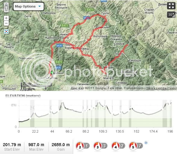
Stage 2: Sant Cebrià de Rossellò - Superbolquera, 160km

x3fev6.png


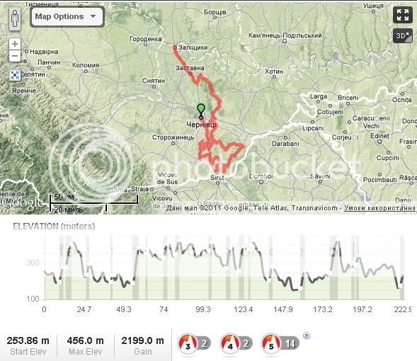
Starting at the Mediterranean coast and ending at the resort town at the top of the Ligne de Cerdagne rail line through Pirineus Orientals, this stage climbs from the sea to a finishing altitude of over 1700m. Yes, this is a climber's stage.

The first half of the stage is straightforward enough; the road starts off at a gradual uphill, which eventually slowly becomes steeper as the race progresses; it is only really after 75km that climbing begins in earnest. But it most definitely begins in earnest. The first climb of the day? A bona fide Hors Categoria slog, up to the Coll de la Llosa, overlooking Montlluís. This is undoubtedly the toughest climb of the day, however; this isn't really a stage designed for solo finishers and gaps in the minutes. So they will gradually descend down into Montlluís and eventually to Sallagosa, where two smaller but potentially selective climbs await us on a loop around the Spanish exclave of Llívia. The second of these, into Èguet (Égat), crests just inside 10km from the stage finish.

However, there is no simple descent finish here, instead attackers must spend most of the time on a flat plateau as they ride into Bolquera, home of the highest altitude mainline train station in France, then the road will turn upward again for a short 1,6km uphill dig into Superbolquera. This isn't an especially challenging last couple of kilometres, and if a rider wants to make a gain of more than a handful of seconds, they will have to risk it on the earlier climb; I was inspired rather by the epic Pescocostanzo stage in the 2008 Giro and rather enjoy this format, as it means that the climbers are induced to attack early, but the diesels can pull them back with the flat - but because there is that short uphill dig at the end again, the gap can be rebuilt, or an attacker's gap can melt away if somebody times their effort better. And there has been plenty of climbing put in the legs to wear down the riders as well, meaning gaps could well be created.

r9pt9l.png


Climbs:
Coll de la Llosa (HC) 24,8km @ 5,0%
Cotzé (cat.2) 7,8km @ 6,7%
Coll d'Èguet/Col d'Égat (cat.2) 6,0km @ 6,6%
Superbolquera/Superbolquère (cat.3) 1,6km @ 6,3% (max 12%)

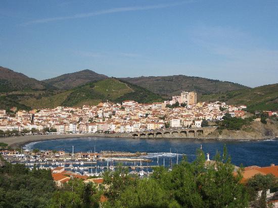
Sant Cebrià de Rossellò:
76180


Superbolquera:
001Superbolquere_HD.jpg
 
Sep 8, 2010
1,441
0
0
Visit site
Tour of Japan || Stage 16: Shibukawa - Utsunomiya Japan Cup Course, 195 km

14dpkzo.jpg


After rest day number 2 we will travel north west around Tokyo. The Gunma prefecture and then Tochigi will be reached. After some climbing of Kasuo Pass, the race will have a flat part, before it will hit the well known course of the 1990 World Championships and since 1992 of the Japan Cup. Five rounds will be done on these roads. The winner has to be a good puncheur or uphill sprinter. But after over two weeks of racing you never know with the GC overall contenders.

otizrm.jpg


Climbs
Cat. 2 // Kasuo Pass (1073m), 11,2k @ 4.3%.
Cat. 4 // Kogashi (305m), 3,6k @ 3.4%.

Shibukawa
shibukawa-city-from-view.jpg


Utsunomiya
53107418.jpg
 
Sep 8, 2010
1,441
0
0
Visit site
Tour of Japan || Stage 17: Utsunomiya - Minamiboso, 216 km

23uea82.jpg


Today the sprinters get their last chance before the final criterium on Sunday in Tokyo. This stage is so flat, that we don't need a profile for it. Starting from the center of Utsunomiya, the race travels through the populous areas in the region around Tokyo. Then we hit the Boso Peninsula and we will ride down to its southern tip for the sprint.

Climbs
none.

Utsunomiya
Utsunomiya2-300x225.jpg


Minamiboso
42472973.jpg
 
Sep 8, 2010
1,441
0
0
Visit site
Tour of Japan || Stage 18: Kurihama - Izu, 198 km

2djcm0j.jpg


We are two and half weeks into it now. It's Thursday and another 3000 Meters of climbing are waiting for the peloton. This is the first of three decisive stages. As you can see, this stage features a lot of smaller and medium climbs. So it is more a stage, where you have to pay attention. Most of these climbs are short and/or not really steep. Well, and if nothing happens today, we can still witness a stunning landscape. But, you can be sure, tomorrow things will change and on Saturday's stage anyway.

2ujh5hj.jpg


Climbs
Cat. 4 // Manazuru (136m), 3k @ 3.6%.
Cat. 3 // Shimotaga (172m), 2,3k @ 7.1%.
Cat. 2 // Mt.Omuro (346m), 6,6k @ 4.9%.
Cat. 4 // Nakaizu by-pass (328m), 2,5k @ 5.9%.
Cat. 2 // Route 59 (503m), 5,8k @ 5.0%.
Cat. 2 // Route 411 (804m), 11,9k @ 4.6%.
Cat. 2 // Nishi-izu Skyline (908m), 4,7k @ 6.0%.

Kurihama
36379745.jpg


Izu Peninsula
4540149487_338942247e_o.jpg
 
Oct 28, 2010
1,578
0
0
Visit site
Interesting thing: when you devise parcours to a fantasy tour for the first time you’re trying to do it in the best possible way, so doing it once more, not copying the previous creation (especially when the chosen area is not very big) is a hard mission. Generally speaking I did not plan to create my tour once more but, as my main inspiration was a train and all the idea is based around changing of direction between destination points from edition to edition I think it is not completed without reverse way parcours.

The new purpose was set – to develop an old idea not copying it. So apart from destination points I used different cities/towns for a start/finish and found different climbs. Basically no one ascend from the previous race features there, I was forced to include some passes (the ring of climbs from the end of stage 4 (in stage 4) and two passes from stage 3 (in stage 6)) but now they are climbed in the opposite direction (so in fact it’s a different ascend) and while these climbs were decisive in their stages from the old tour now they are earlier in the race (the decisive climbs are absolutely new).


L’VIV – CHERNIVTSI TOUR (reverse way)

Stage 1. Chernivtsi – Zalischyky, 223km

2_Stage1.jpg


Long stage at the beginning of the race, very hilly area: up n down almost without flat sections: biggest climbs are 3km - 6.5% (km 55) and 3.4km – 5.7% (km 177), the others are very different in length and gradient. It ends in a town above the Dnister river on a 3km false flat section (3%).

Photos:
Photo 1. The area
Photo 2. Zalischyky


Stage 2. Kamianets-Podilskyi – Buchach, 175km

2_Stage2.jpg


Though being shorter and less hilly this stage is quite similar to stage one. The most of its distance (apart from starting and finishing sections) is along the Dnister river. The finish profile is complicated by the hill of about 300m – 8% about 500m before the finish line.

Photos:
Photo 1. Kamianets-Podilskyi
Photo 2. Khotyn. The Fortress above the Dnister river.
Photo 3. Dnister
Photo 4. Buchach
 
Oct 28, 2010
1,578
0
0
Visit site
Stage 3. Ivano-Frankivsk – Vorokhta (Zaroslyak), 221km

2_Stage3.jpg


After 2 stages over hills of Bukovina and Dnister river area the race leads to first mountains. Very different climbs from 700m to 6km long along the route (the hardest is on about km50: 4.6km – 8.5%). Finish profile is 5km – 5.5% in Zaroslyak sport camp near Vorokhta.

Photos:
Photo 1. Ivano-Frankivsk
Photo 2. Zaroslyak


Stage 4. Bukovel – Mizhhirya, 198km

2_Stage4.jpg


Another mountain stage: From the biggest Ukrainian ski resort to the south passing the range of 5 climbs near Rakhiv (it’s the best place where the road allows you to have a range of ascends on relatively long climbs 2.5-8km with gradients 6% and more. These are the same climbs that featured in stage 4 of previous race but as I said before, the direction of climbing is opposite and climbs are earlier in the race). Then – to the north-west with climbs: 5km – 5%, 3.5km – 5.5% and 1km – 4.5%. Last two of them is in fact one climb 10km before the finish.

Photos:
Photo 1. Bukovel
Photo 2. Mizhhirya


Stage 5. Khust – Uzhgorod, 172km

2_Stage5.jpg


Previous stages happened to be pretty long overall and it would be stupid to make another ~200km stage in mountains, particularly having many beautiful places in the mainly flat Zakarpattia region. Of course I found some hills (one of them even 4km long) but it is the land of quiet towns, castles and people who’s language is hard to understand at first :). So this stage is for spriners.

Photos:
Photo 1. Khust
Photo 2. Zakarpattia 1
Photo 3. Zakarpattia 2
Photo 4. Zakarpattia 3
Photo 5. Uzhgorod
 
Oct 28, 2010
1,578
0
0
Visit site
Stage 6. Svaliava – Vyshkiv, 198km

2_Stage6.jpg


The last day in mountains. The main climbs are 5km - 5% (km. 22), 5km – 7.5% (km57), 4km – 5% (km 103) and two decisive climbs in the end (Vyshkiv pass): 6km – 4.5% and 2km 4.5%.

Photos:
Photo 1. Svaliava
Photo 2. Vyshkiv


Stage 7. Halych – L’viv, 125km

2_Stage7.jpg


The last stage is the shortest, but considering length of previous stages (2 about 170km, 2 about 200km and 2 about 220km) it’s quite justifiable. In fact the race begins after km120 (5km to go) due to 2 hills in the city: the first is about 4km to go (700m – 9.0%, max 14%) and second 500m before the finish is cobbled (800m – 5.8%).

Photos:
Photo 1. Halych
Photo 2. Last 5km. Hill #1
Photo 3. Last 5km. Hill #2


PS: I think if I’ll ever decide to create a fantasy race once more I’ll surely choose the region with better roads (where roads are really satisfactory for riding a road bike), sad to say but it means not here :(
 
Kvinto said:
Interesting thing: when you devise parcours to a fantasy tour for the first time you’re trying to do it in the best possible way, so doing it once more, not copying the previous creation (especially when the chosen area is not very big) is a hard mission. Generally speaking I did not plan to create my tour once more but, as my main inspiration was a train and all the idea is based around changing of direction between destination points from edition to edition I think it is not completed without reverse way parcours.

This is an interesting point. I have thought about having another go at the Tour des Pays-Basque Française and the Vuelta a Navarra, but also I have in mind some kind of Grand Tour of the Basque Country (using all the lands claimed as Basque), and there are so many great underused climbs I didn't use in my Vuelta (I didn't go into Galicia, or utilise the Pyrénées at all). I think with smaller and shorter tours reusing stage towns or key climbs is fine, but it should perhaps not become sacrosanct the way some parcours do (the TDU for example) - though sometimes, a bit of tradition is a good thing - the Vuelta a Burgos always finishing with the Lagunas de Neila climb, for example.
 
In the heart of the Pyrénées, I spy a queen stage!

Stage 3: Montlluís - Mines de Batère, 184km

263ud69.png


Another queen stage that finishes on an MTF, but still at a lower altitude than it started (I must stop doing that), this will be the day that the GC battle really takes shape. A saw-toothed profile which looks like four climbs taking place inside a half-pipe, thanks to the stage start by the UNESCO World Heritage site that is the Citadel and city walls of Montlluís. From here the stage begins, rather oddly, with a long and gradual descent, though it is mostly very straight and non-technical; the breakaway of the day could be an unusual one as a result, or they may wait until the first 20km of the day are done and the gradient flattens out a bit. We then take on three climbs, with the final one being very long and gradual, ahead of turning towards the Col d'Ares, which serves as the border between France and Spain in the area.

However, we are not to cross this border; instead, when the péloton hits the town of Arles, they will turn right onto the D43 and the race gets serious. The first 6km of the climb here are tough; gradients max out at 17%, but the overall gradient is only about 7%. Upon reaching the village of Cortsavi, the péloton will then head to the left and complete the climb up to Serrat de Bouchères, before descending back into Arles. This time, however, there will be no turnoff in Cortsavi, and the riders will continue on their quest up to the Coll de la Descarga and shortly after that the destination point, the Mines de Batère. About 3-4km after Cortsavi, the road flattens out and there's a period of false flat. After that, the road narrows down, and turns uphill again; though this last stretch of 9,5km or so only averages 5,7%, it is inconsistent and often exposed, and the road is narrow, so positioning becomes vital. The toughest parts of this latter half of the climb are ramps of 11-12%, which could easily be enough to break this race apart.

Profile of the final climb here. Our destination is the Refugi Vetera/Refuge de Batère, where the road eventually ends. I'm sure somebody will tell me if I'm wrong, but I don't think the Tour de France has ever been here. Maybe the Volta a Catalunya could, but it's a really unused and almost unknown cycling road.

o7tt9z.png


Climbs:
Col de Boca Jalère (cat.1) 12,2km @ 5,4%
Pic Arnou (cat.2) 4,7km @ 5,3%
Col Palomère (cat.1) 20,6km @ 3,6%
Serrat de Bouchères (cat.1) 10,1km @ 6,6%
Mines de Batère (HC) 19,8km @ 6,0%

Montlluís:
citadelle-mont-louis-303117.jpg


Refugi Vetera (Mines de Batère):
41986904_p.jpg
 
Sep 8, 2010
1,441
0
0
Visit site
Tour of Japan || Stage 19: Higashiizu - Kawazuhana (ITT), 44,5 km

ncz682.jpg


Stage 19 will be our second time trial in this tour. Contrary to the first one, this time trial will draw on tradition with legendary tt's like Riomaggiore 2009 or Saint-Étienne 1997. Time trials for the absolute complete rider.
So here we have climbing mixed with descending on technical challenging roads. Right from the start, the riders will face a climb of 5 kilometes, before descending back to the coast. Then the second climb beginns and it is a long one with a few flatter parts or steps to break the rythm. After 32 kilometers the highest point is reached and from here, the riders have to descend. Before a well-deserved rest, they'll have to face another climb of 3,5 km.

wv6906.jpg


Climbs
Cat. 3 // Okawa (313m), 5,2k @ 5.1%.
Cat. 2 // Mt.Asama (400m), 5,2k @ 7.3%.
Cat. 1 // Shirada (933m), 11,2k @ 5,3%.
Cat. 3 // Kawazuhana (566m), 3,5k @ 5.2%.

Higashiizu
57685103.jpg


Kawazuhana
36622178.jpg
 
Sep 8, 2010
1,441
0
0
Visit site
Tour of Japan || Stage 20: Atami - Fujisan, 198 km

214z7eo.jpg


Time to create legends or to let your inner Zomegnan be the creator of this iconic stage. On this penultimate day of the race, the peloton will face the mighty Fujisan. And since we are not the Tour de France of 2009, they will have to climb this beast twice. To Japanese people this volcano is holy.
The stage starts from the northern tip of the Izu peninsula in Atami. Those poor lads will be able to see the Fujisan from there. To be honest, they can see the 3776m giant from almost every part of the stage. And today the climbing starts from the start. With the over 9% steep climb to Mt.Mikumi the suffering continues. Then we'll have a flatter part to kilometer 75. From here and the north side, we will take on Fujisan for the first time. After the descent, the peloton hits another counter-climb of nearly eleven kilometers, before descending into Fujinomiya. From here it is 30 kilometers to go, 30 k with 2100m of climbing.

24b3wxi.jpg


Climbs
Cat. 1 // Route 20 (862m), 13,7k @ 6.1%.
Cat. 1 // Mt.Mikuni (1140m), 7,1k @ 9.4%.
Cat. HC // 5th Station Kawaguchiko Subaru Line (2325m), 19,9k @ 6.8%.
Cat. 2 // Sonota (1658m), 10,7k @ 5.4%.
Cat. 1 // Yamamiya (1038m), 13,7 k @ 6.0%.
Cat. HC // Fujisan (2336m), 15,5k @ 8.4%.

Atami
17553455.jpg


Fujisan
fujiSanHakone32512267390498790.jpeg
 
Sep 8, 2010
1,441
0
0
Visit site
Tour of Japan || Stage 21: Tokyo - Chiyoda Criterium, 100 km

xe5009.jpg


The last day of these three weeks, brings us into Japan's capital. We will see a dead flat criterium around the Imperial Palace and the Tsukiji fish market. Nine laps on the program.

Tokyo Imperial Palace
3017_01.jpg


Tsukiji fish market
172869.jpg
 
Lupetto said:
Tour of Japan || Stage 20: Atami - Fujisan, 198 km

214z7eo.jpg


Time to create legends or to let your inner Zomegnan be the creator of this iconic stage. On this penultimate day of the race, the peloton will face the mighty Fujisan. And since we are not the Tour de France of 2009, they will have to climb this beast twice. To Japanese people this volcano is holy.
The stage starts from the northern tip of the Izu peninsula in Atami. Those poor lads will be able to see the Fujisan from there. To be honest, they can see the 3776m giant from almost every part of the stage. And today the climbing starts from the start. With the over 9% steep climb to Mt.Mikumi the suffering continues. Then we'll have a flatter part to kilometer 75. From here and the north side, we will take on Fujisan for the first time. After the descent, the peloton hits another counter-climb of nearly eleven kilometers, before descending into Fujinomiya. From here it is 30 kilometers to go, 30 k with 2100m of climbing.

24b3wxi.jpg


Climbs
Cat. 1 // Route 20 (862m), 13,7k @ 6.1%.
Cat. 1 // Mt.Mikuni (1140m), 7,1k @ 9.4%.
Cat. HC // 5th Station Kawaguchiko Subaru Line (2325m), 19,9k @ 6.8%.
Cat. 2 // Sonota (1658m), 10,7k @ 5.4%.
Cat. 1 // Yamamiya (1038m), 13,7 k @ 6.0%.
Cat. HC // Fujisan (2336m), 15,5k @ 8.4%.

1jxbmt.jpg
 
May 6, 2009
8,522
1
0
Visit site
Libertine Seguros said:
In the heart of the Pyrénées, I spy a queen stage!

Stage 3: Montlluís - Mines de Batère, 184km

263ud69.png


Another queen stage that finishes on an MTF, but still at a lower altitude than it started (I must stop doing that), this will be the day that the GC battle really takes shape. A saw-toothed profile which looks like four climbs taking place inside a half-pipe, thanks to the stage start by the UNESCO World Heritage site that is the Citadel and city walls of Montlluís. From here the stage begins, rather oddly, with a long and gradual descent, though it is mostly very straight and non-technical; the breakaway of the day could be an unusual one as a result, or they may wait until the first 20km of the day are done and the gradient flattens out a bit. We then take on three climbs, with the final one being very long and gradual, ahead of turning towards the Col d'Ares, which serves as the border between France and Spain in the area.

However, we are not to cross this border; instead, when the péloton hits the town of Arles, they will turn right onto the D43 and the race gets serious. The first 6km of the climb here are tough; gradients max out at 17%, but the overall gradient is only about 7%. Upon reaching the village of Cortsavi, the péloton will then head to the left and complete the climb up to Serrat de Bouchères, before descending back into Arles. This time, however, there will be no turnoff in Cortsavi, and the riders will continue on their quest up to the Coll de la Descarga and shortly after that the destination point, the Mines de Batère. About 3-4km after Cortsavi, the road flattens out and there's a period of false flat. After that, the road narrows down, and turns uphill again; though this last stretch of 9,5km or so only averages 5,7%, it is inconsistent and often exposed, and the road is narrow, so positioning becomes vital. The toughest parts of this latter half of the climb are ramps of 11-12%, which could easily be enough to break this race apart.

Profile of the final climb here. Our destination is the Refugi Vetera/Refuge de Batère, where the road eventually ends. I'm sure somebody will tell me if I'm wrong, but I don't think the Tour de France has ever been here. Maybe the Volta a Catalunya could, but it's a really unused and almost unknown cycling road.

o7tt9z.png


Climbs:
Col de Boca Jalère (cat.1) 12,2km @ 5,4%
Pic Arnou (cat.2) 4,7km @ 5,3%
Col Palomère (cat.1) 20,6km @ 3,6%
Serrat de Bouchères (cat.1) 10,1km @ 6,6%
Mines de Batère (HC) 19,8km @ 6,0%

Montlluís:
citadelle-mont-louis-303117.jpg


Refugi Vetera (Mines de Batère):
41986904_p.jpg

Is that a hint?
 
Absolutely not. Your race is your race. I had designed this race before I knew you were working on a Volta, and there are many, many great stage finishes in the main body of Catalunya that are going unused, that it's no big deal not to cross the border into the French part, since the real life race doesn't do that often if ever.
 
Sep 8, 2010
1,441
0
0
Visit site
Coming next...two versions of the Tour Méditerranéen. The first version will be a classic stage race starting from Lodève and finishing in Girona. The second race tries to bring some new elements into road cycling. It will in Monte Carlo and finish in the San Remo region. I was a little bored of Mont Faron every year, so I looked out for new possibilities.

I hope to finish this tomorrow, a few details are still missing.
 
May 6, 2009
8,522
1
0
Visit site
Stage 1 - Barcelona - Blanes - 156km:

Map and profile

Stage 1 starts from the world famous Basílica i Temple Expiatori de la Sagrada Família which comes complete with UNESCO World Heritage Status, designed by the world renowned Catalan architect Antoni Gaudí in the 19th century. The peloton races through Barcelona and along the Costa Brava with constant up and down climbing which should test out anybody who not on good form. The peloton turns right at Torre de Tarrant and travels through the outer part of the seaside town of Blanes, passes through Lloret de Mar, onto Tossa de Mar where the peloton is greeted with an 8km climb with sections hitting 19.2%. The next climb the peloton will ride through is Vidreses before passing through Torre de Tarrant for a 2nd time before the uphill run to the finish line in Blanes with a slight descent to the finish line.

Sagrada Família:

800px-Sagrada_Familia_01.jpg


Blanes:

blanes-marina.jpg
 
Here's my version of the Deutschland-Tour. It's a lot less ambitious than BR's 21 day version but it has it's own charms.

The primary aim is to show that a quite challenging 9-day D-Tour can be done completely on German soil without venturing abroad. I would even say that it's a race for any type of stage racers.

Stage 1: Berlin-Cottbus, 150km

a flat stage to kick things off

Stage 2: Dresden-Fichtelberg, 179 km

A challenging stage that ends with an uphill finish after a long false flat section

http://www.tracks4bikers.com/tracks/show/77118

Finish location

http://deutschland.yakohl.com/pic/fichtelberg_2412010.jpg

Stage 3: Plauen-Schwandorf, 197km

A transitional stage to get closer to the next set of mountains

Stage 4: Traunstein-Berchtesgaden, 177km

http://www.tracks4bikers.com/tracks/show/77157

A stage of short climbs and steep ramps. The first part of the Rossfeldringstraße and the mini Mortirolo that is the Dürreckstraße with it's summit at 14km to go make up the main difficulties.

Stage 5: Bad Reichenhall-Spitzingsee, 153km

http://www.tracks4bikers.com/tracks/show/77182

An initially flat stage before the Sudefeldpass and the final climb of the Spitzingsattel with just 1.5 km to go

A look at the lake and the finish

http://upload.wikimedia.org/wikipedia/commons/c/c2/Bavaria_Spitzingsee_from_Rosskopf.jpg

Stage 6: Bad Tölz-Lindau, 196km

A view of the finish in the historic part of the city

http://www.itcwebdesigns.com/tour_germany/lindau05.jpg

Stage 7: Villingen-Schwenningen-Freiburg, 194km

A stage that does it best to avoid the big climbs to set up the big finish of the last 2 days

Stage 8: Vogtsburg-Vogtsburg, 45km

http://www.tracks4bikers.com/tracks/show/77123

A long TT with a twist, 4 small climbs to break up the rhythm through the vineyards of Kaiserstuhl

Kaiserstuhl

http://www.frsw.de/fotos04sep/kaiserstuhl-nord.jpg

Stage 9: Offenburg-Hochblauen, 150km

http://www.tracks4bikers.com/tracks/show/77453

After a punishing TT comes the queen stage of the race and the big finish as it's literally the last chance for the climbers

Kandel and the chain of Notschrei, Kreuzberg and the final climb of Hochblauen should be enough for the climbers to detonate the race should they find themselves having to gain time after the TT

Hochblauen

http://www.martinmkool.com/HochblauenX.jpg
 
You've got a good combination of stages there, and it would be really interesting as you can't really tell which type of rider it favours. I am most approving of the inclusion of Spitzingsattel, that's a great little climb. I think there's too much of Germany to truly include all of it within just the one week, but perhaps the terrain isn't there for a full three week race, as I think Bavarianrider found with the extremely long flat stages in week 1. It's probably best suited to a Volta a Portugal-style 11-day race or so, maybe I'll give it a go one day.
 
Jan 27, 2011
3,399
0
0
Visit site
The Schwarz Wald is a great area for hilly stages like in the Tirreno-Adriatico, hardly any moments of any flatness in the roads there. Very steep and short climbs - 13% constantly for 500 meters continuously over the day.

I think I'll make a single race day stage for that area once. :)
 
After the big climb up to Les Mines de Batère yesterday, it's an easier - but still not easy - ride today in Pirineus Orientals.

Stage 4: Els Banys d'Arles - Banyuls de la Marenda, 170km

iw2plx.png


The penultimate stage of the Volta dels Pirineus Orientals begins in the town of Els Banys d'Arles (Amélie-les-Bains-Palalda) and begins with two hefty climbs to get the legs tuned up before a rolling, flattening run down to the Mediterranean coast. The riders will then tackle a very gradual climb before arriving in Banyuls de la Marenda. From here there are four circuits of 15km to be taken; the riders will be able to celebrate on the fifth time across the finishing line.

The circuits start by leaving the town on the climb up to the Coll de Llagastera, a shortish climb that nevertheless offers plenty of opportunity for aggressive riders to make a move; it is then a technical, twisty descent into Polilles before the false flat up to the Coll de la Père Camera, and then the flat, waterside run-in, with the final, gradual right-hander coming just 200m from the line. This will make it a very difficult race for the leader's team to control, as it will be very easy for an attacker to get themselves out of sight of the péloton. With the kind of gaps typical of a short stage race like this, we could see a veritable bonanza of attacks on the last two laps.

24ltu1d.png


Climbs:
Montargull (cat.2) 6,9km @ 6,1%
Coll de la Brossa (cat.1) 9,7km @ 6,8%
Coll dels Gascons (cat.2) 9,0km @ 4,1%
Coll de Llagastera (cat.3) 3,7km @ 6,5%

Els Banys d'Arles:
amelie-240717.jpg


Banyuls de la Marenda:
datPhoto1_47b86c7096b11_N.jpg
 
We finish off with the CLM, as is typical of such short stage races.

Stage 5: Banyuls de la Marenda - Banyuls de la Marenda, 21,1km (ITT)

ilwwf7.png


The race-ending time trial starts and finishes in the same place as we finished yesterday, racing to and from Cervera de la Marenda, the final French-Catalan town before the Spanish border. The first half of the chrono features a brief uphill out of the town and onto the coastal roads, but for the most part this is a flat power test along the Costa Vermella/Côte Vermeille until we get to Cervera de la Marenda. At this point the riders will head to the right and have a 3,3km climb at 5% up to the Coll de la Creu. Not the toughest climb a rider will ever have to face, but plenty enough to allow some of the climbers who will have no doubt found plenty to enjoy about this stage race to try to defend their gains against the specialists. Most of the rest of the route is a gradual downhill - mostly very straight and only 3% or so, however, before we have a final technical 3km section with several curves and corners looping around Banyuls de la Marenda and to the finishing line.

ifu9s4.png


Climbs:
Coll de la Creu (no puntable) 3,3km @ 5,3%

This race is similar in format to the short stage races like Algarve, Castilla y León, Burgos and so on, and I would expect the same kind of riders to be successful; it is predominantly a climber's tour, with a bit of a bone thrown to the all-rounders.

Banyuls de la Marenda with the hills in the background:
view-from-my-bedroom.jpg


Cervera de la Marenda:
Cerbere1.jpg
 
Dec 16, 2011
345
0
0
Visit site
Libertine Seguros said:
You've got a good combination of stages there, and it would be really interesting as you can't really tell which type of rider it favours. I am most approving of the inclusion of Spitzingsattel, that's a great little climb. I think there's too much of Germany to truly include all of it within just the one week, but perhaps the terrain isn't there for a full three week race, as I think Bavarianrider found with the extremely long flat stages in week 1. It's probably best suited to a Volta a Portugal-style 11-day race or so, maybe I'll give it a go one day.

I also really like this route. It's a shame that the former organizers nearly always opted to ride the Austrian mountains instead of these.

By the way: the tour op Japan is epic!
 

TRENDING THREADS