• The Cycling News forum is looking to add some volunteer moderators with Red Rick's recent retirement. If you're interested in helping keep our discussions on track, send a direct message to @SHaines here on the forum, or use the Contact Us form to message the Community Team.

    In the meanwhile, please use the Report option if you see a post that doesn't fit within the forum rules.

    Thanks!

Race Design Thread

Page 48 - Get up to date with the latest news, scores & standings from the Cycling News Community.
I had some unfinished business...

Tour touristique de france, stage 17: Lourdes - Saint-Jean Pied de Port (190km)

frherst17.jpg


The third consecutive pyrenee stage will start in every catholic granny's favourite holiday spot: Lourdes.
Since it doesn't finish on a mountain top, the current peloton wil probably view this as a second chance for climbers who didn't live up to expectation. If raced properly, however, this stage can create havoc on the peloton and forms a last chance for the lightweight climbers to distance the heavyweight timetriallers.

A rolling start with some minor hills will be a good warmup for the last HC climb of this tour: the col de Soudet via the small town of Arette. A narrow descent leads us to the town of Larrau, where the 2nd category côte de Larrau awaits the peloton. A short descent brings the peloton to the 3rd climb of the day: the col Bagargui, one of those seldom used French basque climbs, and a typical climb for the region: not too long, steep and a narrow road.

colbagarguidaestprofile.gif


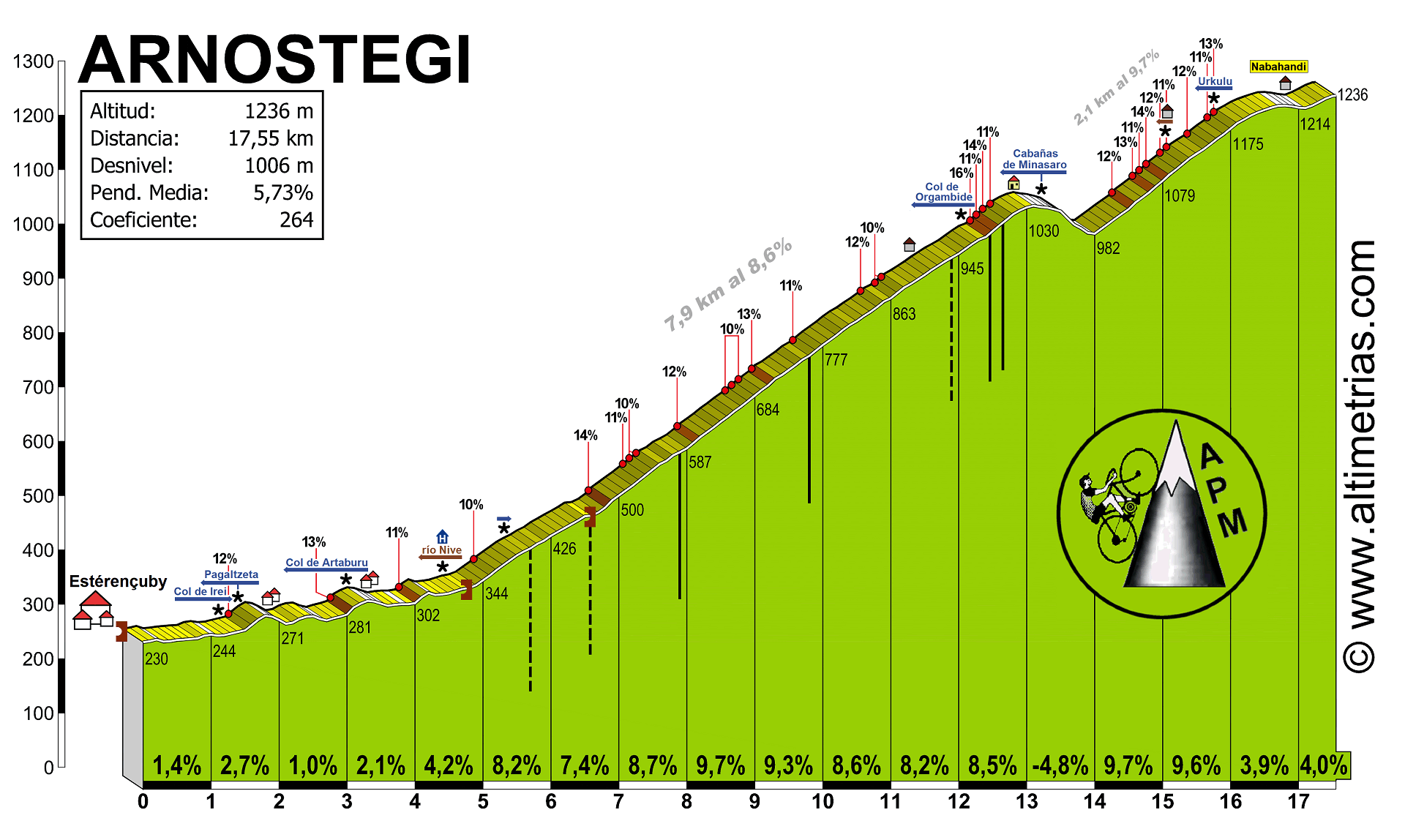
Passing the col de Burdincurutcheta and the little village of Lecumberry, the final two climbs of this edition of the tour will leave a deep impression of those who made it to this point.

frherst17final.jpg


Neither long or high altitude, these climbs are surely steeper than we're used to see in the tour and as such resemble more the climbs the giro likes to use when crossing the Apennines.

The finish in the small town of Saint-Jean Pied the port doesn't add anything special to this stage, but hopefully the fireworks on the road made up for it.
 
Tour Touristique de France, stage 18: Saint-Emilion - Bordeaux (66 km)

Unless something really unexpected happens, this stage will be the final GC deciding stage. This 66 km long time trial will be a test, both for the climbers who had the opportunity to shine the previous 3 stages, as for the powerhouses, who can make up for lost time.

frherst18.jpg


This stage connects two unesco world heritage sites: The wine region of Saint-Emilion with the historical city centre of Bordeaux
 
The last two climbs on the Saint-Jean-Pied-de-Port stage are Bilgossa and Arnostegi (Esterençuby side), right?

I used the other side of Arnostegi (not the one you've descended into Donibane Garazi, but the one via Ondarolle) and descended the side you've climbed before climbing to Errozate in my SJPdP stage of my Tour, and linked Bilgossa to the 4,5km @ 12% Col d'Irey.

Here are the more detailed profiles of the last two climbs in that event:
Bilgosa77.GIF

Arnostegi.gif
 
Libertine Seguros said:
The last two climbs on the Saint-Jean-Pied-de-Port stage are Bilgossa and Arnostegi (Esterençuby side), right?

Definitely not Bilgossa, but a little road 500m more to the west. The summit of this climb has a slightly higher altitude.

Don't know the name of the last climb either, but not Arnostegi. This climb lies more to the north. From Esterençuby you climb the col d'Irey, then you follow the mountain ridge for 6km, around the summit of the Pic d'Itchachéguy and then the descent on the D428.
 
Mar 13, 2009
5,245
2
0
Visit site
My first try at designing a route. I am not an IT specialist so this is still very rough until I can find a better program with which to design routes. Which ones are people using?

This is my idea of a one-day race for the French calendar. It could take place in the early season, around the time of Tour du Haut Var, Etoile de Bessèges and so on. The same teams could then do this race either two days before or after.

Tour du Luberon (195,8 km)

staticmap


graph


It starts in Avignon, then goes over Beaucaire and Tarascon to Arles, which is pancake flat. This is a warm-up phase to allow a break-away to form and to get some km's in on large roads before the real fun starts.

Once in Arles we go over Fontvieille to Les Baux de Provence, the first climb of the day. Not very long nor steep (don't know how to look up this kind of information). On the other side we go down to St. Rémy de Provence. Roads are narrow and very winding.

From there to Cavaillon and Salon de Provence. Rather nice large roads, some hills but nothing too steep. From Salon de Provence a beautiful route through the forest, passing the Chateau de la Barben, to St. Cannat and down to Aix-en-Provence.

First long, steep climb going from Aix to Puyricard. From Puyricard to Le Puy Ste. Réparade, using the same route they used in last year's Paris-Nice ITT but the other way around. Cross over the Durance river to Pertuis.

Out of Pertuis over a hill, now entering the heart of Luberon. Over Ansouis and Cucuron to Lourmarin - now comes the hardest climb, the road to Bonnieux. It starts out easy and the best teams can set up a nice pace. Over the top only an elite group should be left.

They will now embarc on a parcours of constant up-and-down, with many opportunities for attacks, be it uphill or downhill. Through Lacoste and Ménerbes we go to the ghost town of Oppède-le-Vieux with a very steep short climb. This might be the ideal spot to do the decisive attack. But be sure to keep some energy for the downhill and most of all for the flat run-in to Cavaillon. Finish in the center of Cavaillon.
 
No problem, Christian - the more contributors the better! I've put links to the four main mapping softwares in the first post in the thread now to help out, since we have been asked a few times about which software to use to best map things out, but the posts are repeatedly lost in the thread.

I hope this helps, and anybody wishing to add any further ones to the list, please mention and I will include them in the initial post.
 
Mar 13, 2009
5,245
2
0
Visit site
Vancouver - San Diego

I am starting a new project for a 4th GT: Tour of the West Coast a.k.a. Vancouver - San Diego.

The first stage is a prologue in Vancouver of 4,6 km. Not technical at all, long straights and no real hills. Something for TT specialists.

staticmap


graph


We should already see considerable time differences between TT specialists and climbers after this prologue.
 
Mar 13, 2009
5,245
2
0
Visit site
Stage 2: Nanaimo - Victoria

One for the sprinters on Vancouver island before leaving Canada for good. 163 km through Canadian wilderness. But also some hills in there so it should be interesting to see who of the sprinters can make it.

Stage 2: Nanaimo - Victoria (163 km)


staticmap


graph


Nanaimo:

member_108_1.jpg


Victoria:

Empress-Hotel-Victoria-BC.jpg
 
Mar 13, 2009
5,245
2
0
Visit site
Stage 3: Port Angeles - Olympia. (196 km)

Riders take the ferry from Victoria, BC to Port Angeles. Ride along the beautiful Olympic Peninsula into the state capitol of Washington. Again lots and lots of wilderness. Sprint arrival downtown Olympia. Buta again on a slight uphill so we might get to see some puncheurs.

staticmap


graph


State Capitol in Olympia:

OlympiaWAHP.jpg
 
Mar 13, 2009
5,245
2
0
Visit site
Stage 4 already has the first MTF and first opportunity for GT contenders to shine and to make up time lost from the prologue. It brings the riders from Olympia to MT. Rainier at around 1400 meters. The place is actually called Paradise. For some riders it will more feel like hell though! It might also be a nice place for a breakaway to make it to the finish. It has lots of time to establish itself on the winding roads along the Puget Sounds as we move up to Tacoma. Since the race leader is likely a TT and/or prologue specialist, he will be unable to defend his lead, thus his team will not chase very hard. The GT contenders might also want to take it slow, not show all their cards just yet and don't want to take responsibility this early in the race.

Stage 4: Olympia - Paradise (Mount Rainier) MTF) (172 km)

staticmap


graph


Mount Rainier:

51966.jpg


Hiking-Mount-Rainier-National-Park.jpg
 
Mar 13, 2009
5,245
2
0
Visit site
Stage 5: Yakima - Spirit Lake (Mount St. Helens) (179 km)

From Mt. Rainier the teams drive on to Yakima in Eastern Washington, where the start of stage 5 is. Complete change of scenery, the Evergreen state turns into the Everyellow state. Are we in Southern California already?! No, just Eastern Washington. From there it goes back west with again two climbs of around 1400 m. Are we going to see the GT contenders today? Many riders might be still tired from Mt. Rainier the day before so expect to see a more elite group at the end of today's finish. Will a breakaway be able to make it or will GT contenders take matters into their own hands?

staticmap


graph


Not there yet ...

palm-springs-sign1.jpg


Are we on the moon now?! Nope, still Washington ... Mount Saint Helens:

stelprdb5156808.jpg
 
Mar 13, 2009
5,245
2
0
Visit site
Stage 6: Yakima - Camas (259 km)

Second start from Yakima, so teams can sleep in the same hotel for two nights. This is the longest stage so far but also a rather easy one. It's a transitional stage, really, getting the riders from eastern Washington right up to Portland. Today they ride for most of the day on the scenic Lewis and Clark Highway, along the mighty Columbia river, which will make for gorgeous sights. Sprint arrival in the small town of Camas because the only bridge across the Columbia in that area is an Interstate! Sprint is very likely since it's the first one since stage 3, sprinters will not want to miss this opportunity.

staticmap


graph


This will be the sights for most of the day:

5633873452_b0ddfc7375.jpg
 
Mar 13, 2009
5,245
2
0
Visit site
Day 7: Rest day. Time for a rest day wrap-up: by now we will hopefully have an outsider in the salmon-pink leader's jersey, who participated in a break of either stages 4 or 5. But we will also have seen which GT contenders are looking good and which ones are struggling, since we already had 1 MTF and one other mountain stage back to back. On the rest day teams stay in Portland and reconnoître the parcours of stage 7:

Stage 7: Downtown Portland TTT (6,9 km)

A new week, a new state! And what better to kick off this 2nd week of the Tour of the West Coast than a TTT. This is a very short TTT but again (like the prologue) very much tailored to specialists. Mostly flat and long, broad straight roads. The team with the best rouleurs will be able to make a difference. Start and finish is by the University of Portland Campus, we will get to see a lot of the downtown area. Often times riders will pass the same block twice, so spectators have plenty to watch and won't miss any of the action.

staticmap


graph
 
Whoa, that is a brutally insane TTT parcours. All those corners! Just a word of warning though - UCI regs require special dispensation for a stage of over 240km in length, so if you have more than one they may come down like a ton of bricks on you. Still, it's an interesting idea as it gives us a bit more of the US than we're used to seeing. Any idea of the gradients and profiles of some of these climbs?
 
Mar 13, 2009
5,245
2
0
Visit site
Libertine Seguros said:
Whoa, that is a brutally insane TTT parcours. All those corners! Just a word of warning though - UCI regs require special dispensation for a stage of over 240km in length, so if you have more than one they may come down like a ton of bricks on you. Still, it's an interesting idea as it gives us a bit more of the US than we're used to seeing. Any idea of the gradients and profiles of some of these climbs?

Hm I must admit I am not 100% familiar with the parcours I chose but having visited Portland last year I found that most intersections are quite large and wide so I don't know if they cause a big problem to most teams? On the other hand there might be some problems with light rail tracks on some of those streets.

I didn't know that you need special UCI approval for a stage over 240 km, I'll keep that in mind. I had considered skipping that one altogether and just go straight to the TTT but then I thought you must give some to the sprinters too.

Unfortunately I have no idea for the gradients for those climbs ... do you know a site where I might be able to look it up? The numbers on the profiles are feet/miles, that had me confused in the beginning!

I am trying to make a nice mix between big cities such as Vancouver and Portland, medium sized towns such as Tacoma and Olympia and complete countryside such as Vancouver Island and Olympic Peninsula. Also the weather can play a major role as in Western Washington it is often rainy, windy and foggy, then the next day in Yakima it will be really hot and of course by the time you hit San Diego even hotter. So riders have to be able to perform in all conditions
 
Christian said:
Stage 7: Downtown Portland TTT (6,9 km)

A new week, a new state! And what better to kick off this 2nd week of the Tour of the West Coast than a TTT. This is a very short TTT but again (like the prologue) very much tailored to specialists. Mostly flat and long, broad straight roads. The team with the best rouleurs will be able to make a difference. Start and finish is by the University of Portland Campus, we will get to see a lot of the downtown area. Often times riders will pass the same block twice, so spectators have plenty to watch and won't miss any of the action.

staticmap


graph

i would be very interested to watch this TTT, but honestly it seems like a bit much. a ITT like this could work out, but to make it a TTT with so many 90 degree bends it would probably turn into a crash fest. Very interesting idea though.
 
Mar 13, 2009
5,245
2
0
Visit site
gerundium said:
i would be very interested to watch this TTT, but honestly it seems like a bit much. a ITT like this could work out, but to make it a TTT with so many 90 degree bends it would probably turn into a crash fest. Very interesting idea though.

Yes I have thought about it some more and I think you are right. For example I was thinking it will be very difficult for teams to switch the rider that leads because they barely have the time to do it on the straight parts. Before they get to it, there is already the next turn. So I would imagine 2 or 3 riders would lead for the whole time, thus kind of beating the purpose of a team effort.

The advantage I imagine would be that these are large intersections so teams wouldn't have to slow down much at all in the corners
 
I like the idea of having a road race with fixed gears/single speed. Make it hilly but not so hilly that it gets ridiculous (;)) People can only use one gear ratio of their choice so no cheeky bike changes before and after hills or before the final sprint.
 
Mar 13, 2009
5,245
2
0
Visit site
Stage 8: Salem - Newport (156 km)

After the demanding TTT teams assess the damages and get started for real on this second week of the three week Tour of the West Coast. After the very long stage along the Columbia in Washington (259 km), the rest day and the nerve-racking TTT, this is a rather easy one to get things roling again. But watch out for the weather: crosswinds, fog and rain might be a factor.

We get to see the State Capitol of Oregon at the start in Salem (the third one so far, after the ones in Victoria and Olympia). From there we head straight west to the beautiful Oregon coast, along which we ride for most of the stage. Since we are right on the ocean, we will have beautiful sights but must be wary of the weather. Finally the arrival is in Newport, where riders will cross the Yaquina Bay Bridge before battling it out in a likely sprint arrival.

staticmap


graph


Oregon State Capitol in Salem:

url


Yaquina Bay Bridge in Newport:

url
 
Mar 13, 2009
5,245
2
0
Visit site
Stage 9: Newport - Eugene (195 km).

Start again from Newport, so no transfer after yesterday's arrival, riders and staff always appreciate that. We go back inland again until we cross the mighty I-5. Watch for the towns we pass today: Lebanon, South Lebanon, Sweet Home and Springfield (official home of the Simpson) are only some of the names to remember. It also gets hillier again - maybe a good stage for a breakaway? Arrival in the College town of Eugene, which has the reputation of being quite hippie-esque. After having done a TTT around Portland State University several days earlier, riders now arrive by the University of Oregon.

staticmap


graph


The college town of Eugene will host today's arrival:

url
 
Mar 13, 2009
5,245
2
0
Visit site
Stage 10: Ashland - Crater Lake (195 km)

From one university town to another, from Eugene to Ashland, famous for its yearly Shakespeare festival. Riders will hardly have the time to appreciate the beauty of the landscape they pass today as this is the queen stage of the oregonian episode of this year's Tour of the West Coast. From Ashland we go to Klamath Falls and finish at Crater Lake. The race takes place almost entirely at high altitude and the finish is at around 2000m. Now we will see whose altitude training from the early season really paid off and who has been slacking. Until before this stage an outsider might still be in the salmon-pink jersey but today the GC favourites must show their hand.

staticmap


graph


This will be the rewarding sight at the end of today's stage:

crater_lake_large1.jpg
 

TRENDING THREADS