- Feb 20, 2010
- 33,248
- 15,774
- 28,180
Stage 4: Djúpivogur - Neskaupstaður, 174km


Climbs:
Öxi (cat.1) 9,4km @ 5,5%
Stefansbud (cat.2) 2,0km @ 10,2%
Norðfjarðarvegur (cat.3) 1,7km @ 7,1%
Oddskarð (cat.1) 7,0km @ 9,5%
Before we start here, I will explain the logistics, as this is a lengthy transfer to a small community on the east of the island. After the third stage, much of the equipment will be driven along the ring road to the town of Höfn í Hornafirði. Höfn only has the one hotel, so naturally it is not capable of holding an entire race caravan, even for such a small event, so for this I have catered with the provision of boats, possibly cruise-style, to house people overnight. They will come in handy for riders and teams during this eastern leg of the race as small towns are unable to cater for the quantity of people arriving. The riders themselves will stay in Keflavík, close to the airport, before flying to Höfn airstrip early on the next day, when they will then take a shorter transfer by team bus to the small fishing town of Djúpivogur, where this longest stage of the race begins.
The scenery starts off as it means to go on in this stage, with one of the first sights being this waterfall. Maybe it's not the Sottoguda Gorge, but it's not bad, huh? After a short run on this the climb of Öxi begins. Here is an account from a German cyclotourist of the trials and tribulations of this infamous road - very smooth surface, but still noticeably a dirt road. While the riders are forcing their way up this gradual climb, the helicopters can look at the scenery. 5,5% is not enough to kill, but on unpaved roads it probably can cause a bit of damage. The road's in better nick than this now, but let's face it... this is not fun. The ascent at Stefansbud, actually a short and very steep rise that is a separate part of Öxi, is more of a threat, being over 10% on similar roads, but being back on Route 1, they are at least somewhat smoother and rideable. I wanted to put some suffering in the riders' legs ahead of the closing stages, but wanted to make sure that luck with regard to punctures and so on wouldn't be totally decisive, so these are a long, long way from the finish. The road starts to level out and the tarmac begins again, much to the riders' relief, on our way to Breiðdalsvík. This dramatically located fishing town is the start of the second part of our stage.
The roads from Breiðdalsvík along the coast are sweeping and grandiose; the Suðurfjarðavegur takes us along dramatic roads around Stöðvarfjörður, the glorious vistas of Fáskrúðsfjörður, before heading inland towards Fjarðabyggð through the Reyðarfjörður Tunnel. For this reason you must ignore the sharpest spike on the profile - it does not exist.
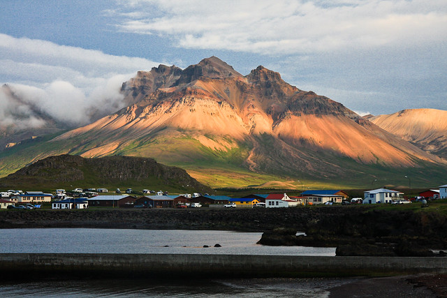
After leaving Fjarðabyggð, there is a small categorised climb on the coast road heading to Eskifjörður, an important town and port for eastern Iceland, but more importantly for the day's cycle racing, the base of our final climb for the day. On this picture of the town you can see the climb snaking away on the left hand side, as the road starts to turn dramatically uphill. The climbing up incredible landscape snaking its way up to the ski resort at Oddskarð is 7km long, but it averages a punishing 9,5%, and as you can see from the profile, there's not much in the way of let-up - it's 3km at 9%, followed by one at just 6%, then 3km at over 11%, with those last 2km being the toughest of all. The summit of the climb is just 15km from the line too, so expect plenty of GC action here - the riders have just got a similarly steep and fast descent and then a 5km flat run in to Neskaupstaður, a key fishing town on the edge of the Nörðfjörður, to finish. This will really turn the GC upside down no doubt, as this is definitely a climber's finish.
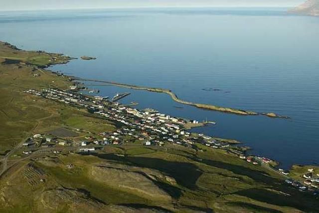
Djúpivogur:

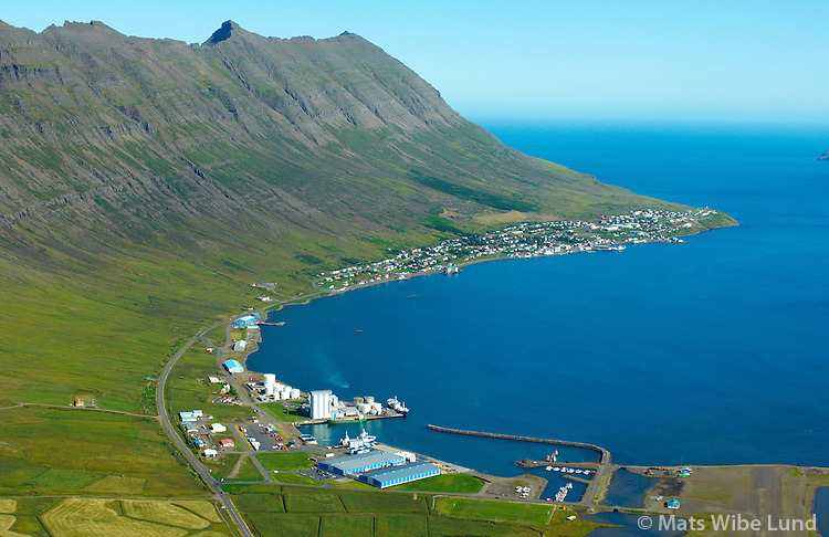
Neskaupstaður:
(on that - I encourage you all to check out Mats Wibe Lund's site - the Icelandic Image Library. Some really breathtaking stuff in there)
Climbs:
Öxi (cat.1) 9,4km @ 5,5%
Stefansbud (cat.2) 2,0km @ 10,2%
Norðfjarðarvegur (cat.3) 1,7km @ 7,1%
Oddskarð (cat.1) 7,0km @ 9,5%
Before we start here, I will explain the logistics, as this is a lengthy transfer to a small community on the east of the island. After the third stage, much of the equipment will be driven along the ring road to the town of Höfn í Hornafirði. Höfn only has the one hotel, so naturally it is not capable of holding an entire race caravan, even for such a small event, so for this I have catered with the provision of boats, possibly cruise-style, to house people overnight. They will come in handy for riders and teams during this eastern leg of the race as small towns are unable to cater for the quantity of people arriving. The riders themselves will stay in Keflavík, close to the airport, before flying to Höfn airstrip early on the next day, when they will then take a shorter transfer by team bus to the small fishing town of Djúpivogur, where this longest stage of the race begins.
The scenery starts off as it means to go on in this stage, with one of the first sights being this waterfall. Maybe it's not the Sottoguda Gorge, but it's not bad, huh? After a short run on this the climb of Öxi begins. Here is an account from a German cyclotourist of the trials and tribulations of this infamous road - very smooth surface, but still noticeably a dirt road. While the riders are forcing their way up this gradual climb, the helicopters can look at the scenery. 5,5% is not enough to kill, but on unpaved roads it probably can cause a bit of damage. The road's in better nick than this now, but let's face it... this is not fun. The ascent at Stefansbud, actually a short and very steep rise that is a separate part of Öxi, is more of a threat, being over 10% on similar roads, but being back on Route 1, they are at least somewhat smoother and rideable. I wanted to put some suffering in the riders' legs ahead of the closing stages, but wanted to make sure that luck with regard to punctures and so on wouldn't be totally decisive, so these are a long, long way from the finish. The road starts to level out and the tarmac begins again, much to the riders' relief, on our way to Breiðdalsvík. This dramatically located fishing town is the start of the second part of our stage.
The roads from Breiðdalsvík along the coast are sweeping and grandiose; the Suðurfjarðavegur takes us along dramatic roads around Stöðvarfjörður, the glorious vistas of Fáskrúðsfjörður, before heading inland towards Fjarðabyggð through the Reyðarfjörður Tunnel. For this reason you must ignore the sharpest spike on the profile - it does not exist.
After leaving Fjarðabyggð, there is a small categorised climb on the coast road heading to Eskifjörður, an important town and port for eastern Iceland, but more importantly for the day's cycle racing, the base of our final climb for the day. On this picture of the town you can see the climb snaking away on the left hand side, as the road starts to turn dramatically uphill. The climbing up incredible landscape snaking its way up to the ski resort at Oddskarð is 7km long, but it averages a punishing 9,5%, and as you can see from the profile, there's not much in the way of let-up - it's 3km at 9%, followed by one at just 6%, then 3km at over 11%, with those last 2km being the toughest of all. The summit of the climb is just 15km from the line too, so expect plenty of GC action here - the riders have just got a similarly steep and fast descent and then a 5km flat run in to Neskaupstaður, a key fishing town on the edge of the Nörðfjörður, to finish. This will really turn the GC upside down no doubt, as this is definitely a climber's finish.
Djúpivogur:
Neskaupstaður:
(on that - I encourage you all to check out Mats Wibe Lund's site - the Icelandic Image Library. Some really breathtaking stuff in there)


")