
- Sep 20, 2017
- 12,723
- 23,909
- 28,180
After back-to-back epics, a day off for everyone.
Profile
Map

The route
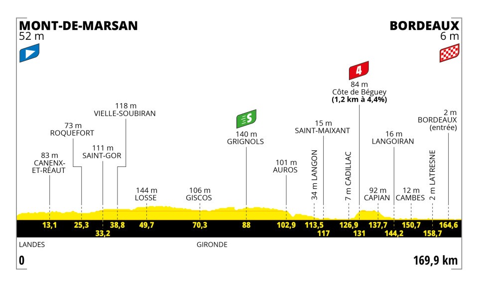
The stage starts from Mont-de-Marsan, right in between Tuesday's stage towns. The route consists of two halves: the first through the Landes, the largest man-made forest in western Europe, the second down the Garonne valley, dominated by wineries. At the point where one gives way to the other, in Grignols, there is the intermediate sprint.

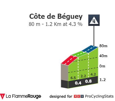
The second half of the route also contains the day's token KOM, Côte de Béguey.
Final kilometres


The most inaccurate map I've ever seen from ASO. Firstly, there's a roundabout just before 5k to go where the text says they pass on the left, but the map shows the opposite. The former should be correct.

Then, to turn onto the Pont-Saint-Jean, the final kilometres map shows one thing, and the finish map shows something else. Here's the kicker: both are incorrect, because the highway exit ramps they show the race taking have been demolished. Hence the crude edit to the map above. It's just three 90-degree turns in short succession. The map warns for a tight turn at the first of these, but it really isn't that bad as far as I can tell from Streetview (the only recent images, from this spring, had roadworks going on...)

To get off the bridge, there's a bit of a complicated gyratory system to go through. No sharp turns, but a lot of changes of direction immediately after one another, with probably a narrowing at the end of the first of the turns.

From there, the final 1.9 kilometres are almost as straightforward as can be.
Profile
Map
The route
The stage starts from Mont-de-Marsan, right in between Tuesday's stage towns. The route consists of two halves: the first through the Landes, the largest man-made forest in western Europe, the second down the Garonne valley, dominated by wineries. At the point where one gives way to the other, in Grignols, there is the intermediate sprint.
The second half of the route also contains the day's token KOM, Côte de Béguey.
Final kilometres
The most inaccurate map I've ever seen from ASO. Firstly, there's a roundabout just before 5k to go where the text says they pass on the left, but the map shows the opposite. The former should be correct.
Then, to turn onto the Pont-Saint-Jean, the final kilometres map shows one thing, and the finish map shows something else. Here's the kicker: both are incorrect, because the highway exit ramps they show the race taking have been demolished. Hence the crude edit to the map above. It's just three 90-degree turns in short succession. The map warns for a tight turn at the first of these, but it really isn't that bad as far as I can tell from Streetview (the only recent images, from this spring, had roadworks going on...)
To get off the bridge, there's a bit of a complicated gyratory system to go through. No sharp turns, but a lot of changes of direction immediately after one another, with probably a narrowing at the end of the first of the turns.
From there, the final 1.9 kilometres are almost as straightforward as can be.


