21 ESP climbs the Vuelta should use

Page 3 - Get up to date with the latest news, scores & standings from the Cycling News Community.
icefire said:
Can't see Unipublic going to unpaved roads like this one. They engaged the authorities to throw some tarmac in Cuitu Negru, but that was a ski station. Trobaniello is in a natural park and that makes things such as paving a road much more difficult.

4 climbs to go. I'm waiting to see something in the Land of Fuentes :D

There's actually more, since I'm going to do some honourable mentions, but those will just get skeleton explanations, rather than the full profiles that I've done for the 17 done so far and the 4 to come.
 
18. Llano de las Ovejas (León)
Stairway to the stars

portillinos.jpg


Ski stations have proven very popular in the hosting of summit finishes in cycling history - La Plagne, Les Arcs, Alpe d'Huez, Malbun, Sestriere, Breuil-Cervinia, Bormio 2000, Superbagnères, Super Besse, Pila... looking back through the annals of the sport, there are dozens of them. The Vuelta's very first summit finish, Aramón Formigal, was at a ski station. Once you get out of the Pyrenées, the climate in Spain means that there aren't so many ski stations (and the lack of Alpine culture affects that as well, of course!), however many of them are still familiar to the Vuelta - Valdelinares, Sierra Nevada, La Covatilla - and new ski station summits are being added to the race on an ongoing basis - Fuentes de Invierno in 2008 and La Manzaneda in 2011 being notable.

One such ski station in the Vuelta's history is El Morredero, which is located in the mountains overlooking Ponferrada, and the ascent to which starts right in the 2014 Worlds' host town. The Vuelta last visited in 2006, a stage which was won by Alejandro Valverde. It wasn't the most exciting stage, with a few tentative moves early on, and in the end hostilities were kept until late on in the stage, unsurprising given it was a one-climb stage and there are a couple of downhill kilometres near the end. The 2010 Vuelta a Castilla y León is the most recent race to head there, and featured a tougher variation on the stage design cloned from the 1997 Vuelta, and resulted in a really great final climb where Ezequiel Mosquera, Igor Antón and Alberto Contador moved away from the group early, an in-form Juan Mauricio Soler attacked beautifully to ride across to them solo, and then they triple-teamed Contador until Antón got away for the stage win.

However, the Alto del Morredero, three-stepped and cruel though it may be, is not the end of the climbing. Oh no. Unlike most ski stations, El Morredero is not the summit of the road it is on, and we can keep on going to one of Spain's toughest passes.

1z5mb9v.png


From Ponferrada, the climb is a little longer than that, but the beginning is just false flat. The climb to the Alto del Morredero proper is 17,8km @ 6,3%. Is that a pretty legit tough climb? Absolutely. Is it HC worthy? Maybe. It might just be a hard cat.1 though, and that's the categorization it was given in the 2006 Vuelta. I think given some of the gradients earlier on it could get away with the ESP, though. However, if you keep on going, there's another step to the climb before reaching the Puerto de los Portillinos, to which point it is 21,7km @ 5,9% which is more like it; but whereas you can turn away from the pass to finish at the Estación de Esquí at El Morredero, you can't do that at Portillinos, so you may as well continue on to finish the climb at Llano de las Ovejas, again after yet another step to the climb, finishing up at nearly 2000m altitude with a grinding 27,4km @ 4,9% in no fewer than five separate steps (weirdly, the sign for Los Portillinos is placed here, showing the altitude for Llano de las Ovejas). The PRC guys compare it (with a couple of false flat kilometres on the beginning) to the Col de la Croix de Fer in its multi-stepped suffering, and although the French monolith bests it in terms of average gradient and metres ascended, Llano de las Ovejas fights back with steepest kilometres and ramps.

Once the climb begins in earnest, it hits its hardest straight out of the gate, and one can expect the bunch to be thinned out a lot by the first few kilometres of climbing - 3,6km averaging 10% and including the toughest gradients of 15 and 16% almost immediately! A couple of easier kilometres at 3-4% allow riders to recoup a bit of their energy before a further kilometre at 10%. Once more we have a kilometre of false flat, before the road kicks back up again and snakes back and forth across the mountainside. The views are scenic, but the suffering is quite extreme as we now start a kilometre averaging a nightmarish 11,5%; each of the next 3km becomes progressively less steep, but the average of these four kilometres is still nearly 9%. Here there is a real respite, in two downhill kilometres before it starts to kick back up again. I guess the best comparison would actually be Portugal's epic Alto da Torre - 28,5km @ 5,1% with a couple of downhill bursts and a max of 17%. But while Torre is in three bursts, Llano de las Ovejas is more inconsistent than that; the next stretch of uphill to the Morredero ski station is at just over 7% for 3,5km; then another slight downhill, then a flat couple of kilometres, then we reach Portillinos with 2km at nearly 9% featuring our last truly tough ramps, getting up to 13%.

If Javier Guillén wanted to put the GPM there I would not complain; nearly 22km at almost 6% is a legit ESP in the way that they've got there, and really all that remains is 4km of mostly flat with a couple of downhill ramps before a final 2km at 5%, so the average gradient does drop from there. But from the other side, the summit is naturally, well, the summit.

Ovejas.gif


From the southwest side, you have another climb which is on the cusp of ESP status, at 18,6km @ 6,1%. Personally I would grant it, mainly because of that brutal final 6km at 9%. The PRC comparison is to the Col de la Colombière, which it is almost a doppelganger for, save for that the slightly flatter section is a bit longer here. The scenery on this side is equally stunning, and it also comes with the additional benefit that is that, unlike the Ponferrada side where Unipublic would either have to have the riders stop at the ski station El Morredero like on previous occasions, or have the summit a way from the finish, likely finishing on another climb, this side gives us the option of "descending" to the ski station, placing the summit around 10km from the finish, of mostly false flat and a couple of stretches of tough descent; alternatively a descent of 35km takes you into Ponferrada where you can finish.

IMG_6293.JPG


So, a climb which is undisputably ESP from one side and probably ESP from the other; how does it fit into stage designing plans? The answer, pleasingly, is pretty well. The climb backs almost perfectly into Fonte da Cova, which I have already visited in this thread; this double is unsurprisingly very popular with traceurs when proposing ideas for La Vuelta. The tough side of each climb leads onto the easier side of the other, but there are options in both directions. For example, this suggestion from APM has a summit finish at La Manzaneda after the Ponferrada side of Ovejas, the Leonese side of Fonte da Cova and A Moeda. In the other direction, this suggestion from PRC has a summit finish at Foncebadón (I'd argue 14,4km @ 6,4% should be cat.1) after La Manzaneda, Fonte da Cova and the south side of Ovejas. You can also see from that how it would look to finish the stage in Ponferrada; it is also possible to replace that flat run-in from the base of the descent with the short and steep Alto del Lombillo, as seen here. Alternatively, a finish at El Morredero would look like this (this stage also climbs both sides of Ovejas giving us more ideas of the possibilities).

There is also the possibility to approach the south side of the climb by coming from Las Gobernadas, which joins the route between Sestil and Ovejas at the middle point, and there's also the option if descending the Ponferrada side of putting a finish at Campo de las Danzas; 14km @ 6% is tough enough for an MTF, although there's not that much room and it would seem a bit unnecessary after Sestil and Ovejas. With there being a ski station at Fonte da Cova, the harder side of Ovejas would back straight into the easier side of that, which would give a cat.1 MTF at 10,7km @ 7,3%. What's certain is that there are a lot of possibilities to utilise, back to back, two of Spain's most underappreciated climbs, and therefore it is a travesty that they do not.
 
19. Turó de l'Home (Cataluña)
The monolith of Montseny

2cypblx.jpg


About halfway between Barcelona and Girona, the Montseny range, lying slightly inland to the south of the main body of the Pyrenées, has its highest peak at 1.712m, upon which a triangulation station stands. This is the Turó de l'Home, and there is a road almost all the way to the summit; a climb which remains bafflingly unknown to professional bike racing. It is well known to cyclotourists, of course, and its convenient location near to two major cities and with some sizable climbs nearby makes it almost ideal for a first stage into the Pyrenées, or for a final stage before a rest day (perhaps following a stage with the likes of Coll de Pradell and Coll de Pal?). And this could be a really big, important mountaintop too.

Turo.gif


There are a number of ways to get up to the summit of Turó de l'Home; only the final six kilometres remain the same to all. The most commonly cited version of the climb, from Sant Celoni, is the one in that profile above, and its vital statistics are 25,6km @ 5,9%. After a few kilometres of false flat, it is generally one of those endless, driving climbs, comparatively consistent (apart from one kilometre of flat around the point that the road to Santa Fe de Montseny links to it, it is uphill at fairly continual rates), but with a few nasty ramps to prevent the riders getting too comfortable in their rhythm; the riders are however given the chance to be climbing for a full 10 kilometres before these ramps begin, so tiredness will already be setting in by the time they get to them. The toughest stretch in terms of this inconsistency is the three kilometres from km 16 to km 19, which feature a number of ramps of 10% or more, including two which hit our maximum, a jarring but not destructive 15%. These lead straight into the false flat kilometre, but the riders don't get long to enjoy this before the road turns uphill again; indeed, the next 2,5km average 9% and include five ramps of over 10%. In fact, the final 6km average a touch over 8% and are the toughest stretch of the climb; however they are not so much tougher than the rest of the climb that everything can be guaranteed to be left until them, such as on other lopsided Vuelta climbs like La Pandera or Cuitu Negru.

There are, as mentioned, many other ways to climb the Turó de l'Home. One popular way is to go from Sant Celoni towards the long but gradual Alt de Santa Fe de Montseny, which is mostly around the high 4s and low 5s, percentage wise. This route features the first 20km of that, then a brief descent to the Coll de Santa Helena, before the steep final 6km of the Turó de l'Home. The overall statistics for this side are 31,0km @ 5,0%, however as you can tell from the profile, this is somewhat easier than the other Sant Celoni side, and it really would be a war of attrition until we got to the final 6km if the Vuelta climbed this side, so while it would still merit the ESP status due to its length, it would be a less interesting race than its parallel face.

A shorter variation on the normal Sant Celoni version is the Rio Tordera side of the climb, which cuts off some of the first part of the climb, but features a steep opening before linking up to the Sant Celoni side just before the village of Montseny; this side shapes up at 19,4km @ 6,6%, a not inconsiderable gradient which puts it in the same statistical realm as the Coll de Pal previously visite on this thread. This also has the benefit that it links absolutely perfectly to the northern face of Collformic, which would likely be a cat.2 climb but would back immediately onto the Turó de l'Home. This would allow for stages such as this one from PRC, with Santa Fe de Montseny backing straight onto Collformic and subsequently onto Turó de l'Home for a very tough triple header to finish.

From the north, one could also climb from Arbuciés, which would take us over the Alt de Santa Fe and then allow us to descend to Santa Helena and finish the Turó de l'Home; this makes 40,6km @ 3,4%, which is super-long, but realistically, the profile shows it would be more sensible to break up the categorisations from this side. Even if we did that, the final 6km would probably be a tough category 2, because as well as the tougher gradient, the riders who have to this point dealt only in pristine tarmac, will suddenly find themselves dealing with some much tougher surfaces.

1076920.jpg


Happily, these multiple faces of the Turó de l'Home mean there are many options for how to incorporate it into a race. While my personal preference would be the full climb of the Alt de Santa Fe and Collformic backing straight into the summit finish as shown above, as this cuts out the false flat and gives us no flat in the last 75km, this is far from the only thing that can be done. The same route can be done in reverse, for starters, allowing us to climb the tougher side of Collformic followed by the easier side of Santa Fe before descending into Sant Celoni. You can also add Collesplanes for another cat.2 climb (8,2km @ 5,7%) from this side too, as per this suggestion. Descending from Santa Fe would also cut the false flat off the start of the climb, making the Sant Celoni side cut down to 21,6km @ 6,4%, and that's ESP by anybody's book. A further option (perhaps more likely for the Volta a Catalunya than La Vuelta) would be to go the Lagunas de Neila route of climbing 80% the climb, descending another face then climbing the full climb (just as they only go to Pasil de Rozavientos in the Vuelta a Burgos, before re-climbing Puerto Collado and then climbing all the way to the summit). This way, the Coll de Santa Helena is the same as the first 19km of the Sant Celoni side, followed by a kilometre at around 5% to join the Santa Fe road; this is totalling in at 20,5km @ 5,2%, probably cat.1, however you could easily then take the 23km descent from there to Sant Celoni and then climb the Turó de l'Home in full. This would also be very similar to what they did in La Vuelta in 2008 with the stage to La Rabassa, first doing the Alt de la Rabassa (until the Aixirivall junction, at 1.830m), then returning to the base to climb all the way to the Nordic skiing station at Naturlandia.

TURO000.jpg


With its location being so close to both Barcelona and Girona it seems odd that the summit should never be considered; while it isn't at the highest of altitudes I can understand why clearing the road to it isn't as high priority as for the ski stations, so it may be less of an option for the Volta a Catalunya. However, what we have here is a real, genuine hors catégorie climb of the classic relentless type; not the super-steep gimmick climbs that Guillén loves, nor the tortuously inconsistent climbs that belie their difficulties with meagre average gradients. This is climbing in the classic sense, grinding the riders down with a serious gradient, but seemingly never ending, shaping up not like the current vogue, but like a timeless classic.
 
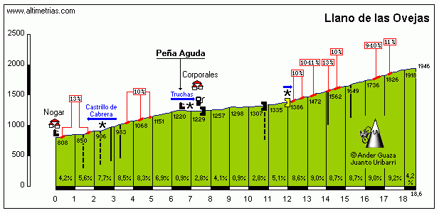
Interestingly, Llano de las Ovejas is being climbed today in Castilla y León, from the Nogár side, although they have split it into a cat.2 climb (Peña Aguda) and a cat.1 climb (Portinillos) even though they are an uninterrupted ascent with a bit of false flat in the middle.

Anyway, almost there now.

20. Alto del Gamoniteiro (Asturias)
Angliru's only real rival

gamoniteiro.jpg


You could argue that Gamoniteiro (Gamoniteiru to locals) is Spain's answer to the Colle di Nivolet. Though the climbs do not resemble each other, they are both similarly mooted every year as a possibility for the local Grand Tour, and every year we go without. Fans have clamoured for Gamoniteiro for a few years now, and though logistical reasons have always been mooted as a reason not to, with them somehow managing to find enough space to finish at Ancares and Camperona, this argument becomes less workable.

One option, given the location, would be to leave a lot of the team cars etc. at La Cobertoria and, like with Zoncolan, Angliru or Kronplatz, just have motos to follow for the last few kilometres. La Cobertoria has the space - it hosted a stage finish in 2006 - and is partway to Gamoniteiro; like Llano de las Ovejas this climb is another world on top of what we already know. The turning to Gamoniteiro is actually a little after the summit of the traditional side of Cobertoria, or a little before the summit of the more brutal Pola de Lena side, after the Cuchu Puercu junction but before Cobertoria itself.

Gamoniteiro.gif


If Lena is not already to the Vuelta what Cortina d'Ampezzo is to the Giro, it should be; Cordal, Cuchu Puercu, Cobertoria, Pajares, La Cubilla, Cuitu Negru and Gamoniteiro all have sides beginning there. There are in fact two sides of Gamoniteiro that begin from Lena, but this is the most discussed side, measuring in at a brutal 16,4km @ 8,9%. For context, the Vuelta often gives Cordal 1st category, and that has the same gradient but barely more than a third of the length! The section from the junction with La Cobertoria - the section that is common to all faces of the climb - is 6,4km @ 9,7%, which in and of itself should be 1st category, especially at the Vuelta where climbs like Urkiola and Peña Cabarga merit that. This is basically a tougher version of those climbs bolted on to the end of a legit 1st category climb. And some would argue that the Lena side of Cobertoria, tragically unused in La Vuelta until finally being included this year, ought to be HC in and of itself, at 10,2km @ 8,5% but with many, many sections over 10% and some parts averaging over 11%. So it is, that after climbing this tough 1st category climb, the riders will then have to turn to the north. Unlike, say, Bola del Mundo, La Pandera where a sizable stretch of flat breaks up the climb before the brutal sections or Cuitu Negru, the pack should already be split down to its bare essentials by the time we get to Cobertoria, for when the real brutality begins. If anything the gradient eases up a little at first, but only to 6,1%, so it's still not inconsiderable climbing. From there on in, the gradient hits 10% at the Collada del Fresno with its awesome views and stays very consistent for a kilometre; then it's down to a comparatively straightforward 8% for a bit before ramping back up; in the last 3,5km it never gets below 10% on average, and consistency starts to fall away, as does the road quality.

gamoniteiro8.jpg


The ramps really start to hit hard here, getting up to 15% at the end of three, ascending in difficulty, 3km from home, a flattening out for no more than 100m is then followed by a spike up to 13%. The last 1,5km is also the toughest, averaging no less than 12%, and with a maximum of just 17% that tells you that it's incessant suffering. It's actually kind of strange that the maximum of such a brutal climb is just 17%; Spain is known for ridiculously inconsistent climbs & it is only really in this that Gamoniteiro cannot compete with its cousin down the road, the fabled Angliru. Gamoniteiro is a whole % less steep, but is 25% longer; the final 6km averaging 10% is a truly brutal climb on its own, & the scenery is a similar Asturian wilderness. Truly, this is a brutal killer.

But as most cycling fans will be aware, there's more than one way to climb La Cobertoria, so naturally there's more than one way to climb Gamoniteiro. You will no doubt be aware of the climb of Cuchu Puercu, a pass which lies on an access road that links La Cobertoria to El Cordal. It has three sides, two of which go through Cordal (via Cordal N and Cordal S from Pola de Lena) and two of which begin in Lena (via Cordal S and via the road to Cobertoria). Climbing via the road we already climbed above, Cuchu Puercu is 7,8km @ 9,6% but that doesn't take us to Gamoniteiru (although we could use it as a lead-in climb). Going via Cordal S, we have a first 5,5km @ 8,9% and a total of 11km @ 6,9%. This then descends briefly before ramping up brutally, giving us a final 8,5km @ 9,5% and a total climb summary of a more than sufficiently ESP-category 20,4km @ 7,3%, as seen on this profile. This puts the toughest stuff at the very beginning (first 5km) and the end (last 8km) with some easing off in the middle, so while it's less consistently brutal than the previous side, it still has more than enough to burn off domestiques early then give us a good length of super tough mano a mano racing.

Alternatively, going to Gamoniteiro from Cuchu Puercu's north face, we arrive at 23,8km @ 6,2%, which is more reminiscent of Bola del Mundo or Mont Caro. This easier side begins with a benign 13,7km @ 5,3%, before ending with the same brutal 8,5km @ 9,5% from the aforementioned side; here racing would likely be more condensed into the final 10km for this reason.

Finally, you have Gamoniteiro from the 'other' side of Cobertoria, the classic side that is so easy to link up to San Lorenzo. This seems comparatively benign, at 17,0km @ 7,6%, mainly because after the summit of the standard 8,1km @ 8,5% that is this side of Cobertoria, you have a kilometre and a half of flat and descent before it ramps up again. This is not the toughest side of Gamoniteiru, but it can be linked up well with Maravio or San Lorenzo, which has to count for something. Well, there is another side of Cobertoria, but who really cares about the false flat Santa Marina via Cortes side? I mean, it averages 3,4% without major ramps. It would be a tragic waste of Gamoniteiro to use Cobertoria from this side to climb it.

1C4EB3E9DE1C4E4D90F81C4E4D889A.jpg


So, how to include it in La Vuelta? A lot of proposals follow ideas such as this one, with the riders climbing Cobertoria W, descending past the turning for Gamoniteiro, then descending via Cuchu Puercu and Cordal to Pola de Lena to start the first side of the final MTF; this has the drawback that the riders will have to tackle the section of road between the Cruce Cuchu Puercu and Cruce Gamoniteiro in both directions (although you would hope that nobody would be far back enough for this to be dangerous to riders, and the Vuelta has done a doubling-back-on-itself stage in recent memory, with Bola del Mundo 2010). This would enable Cobertoria to be the main lead in to its own big brother, and connect well with San Lorenzo too. Another option is to do the same pattern but descending Cobertoria to Lena then climbing Cuchu Puercu via Cordal, but that gives us a steeper descent and shallower climb, which seems contrary to Unipublic's current policy. It would also be a possibility to climb Cobertoria from Lena, then descend via the Cortes side to Santa Marina and climb Gamoniteiro via Cobertoria W; the drawback of this is that it takes the penultimate climb further from the finish, with a 20km descent, but the upside is that though there would still be some doubling back, it would become far less likely to be a problem as the chances of riders being 29km behind are fairly slim.

Another more straight forward option would be to simply climb Cuchu Puercu from its Cobertoria side, and just loop around, descending via Cordal and then climbing Gamoniteiro from the same side we climbed Cuchu Puercu from, like with Lagunas de Neila or La Rabassa as I mentioned before. This would make the penultimate climb 8km at just under 10%, a legit cat.1 climb, but still dwarfed by the final climb, a bit like how Cordal preceding Angliru looks so small. Ultimately, such discussions are splitting hairs; like Mont Ventoux, Gamoniteiro is a climb brutal enough that it doesn't need too much before it; all the racing on the stage will be done on the final climb. But we just need to put something into the riders' legs beforehand to see how they cope with one of Asturias' true beasts, a climb which may come up short, but would not back down in the face of Angliru, the Vuelta's current king of the ring.
 
Before we get to #21, which I'm sure most of those reading will have guessed by now, I'm going to throw in a few 'honorable mentions'. These are for climbs that were either for consideration but rejected, that I just couldn't fit in for whatever reason, or are still super tough climbs that the Vuelta has yet to discover but just aren't quite justifying the ESP categorization. You could argue that some of these are tougher than some of the climbs that made the list, on occasion, but trying to keep things varied, spreading out across the whole geography of Spain and so forth has led to a more eclectic and imo more interesting selection of climbs.

So, here we go.

Alto de La Bobia (Asturias)

Where is it?
In the very westernmost part of Asturias, about halfway between Ribadeo and Grandas de Salime, in the Sierra de la Bobia. Accessible both from Galicia and the rest of Asturias, but little used due to relatively isolated location in both La Vuelta and the Vuelta a Asturias.

How do you climb it?
Hard to say, since there are no fewer than fifteen different ways to climb La Bobia. Many of these are super gradual, in steps, divisible into other climbs, or short. The three ascents of note for this thread are:
- From Meredo (13,5km @ 7,4%)
- From Penzol (23,4km @ 4,4%)
- From Soutelo (10,5km @ 8,0%)

Why did I consider it?
Look at that section in the middle of the Meredo side - 2,5km @ 13%!!! That's brutal. I came very close to including La Bobia because of this side, actually; Its stats are comparable to Luz Ardiden, but it is a lot less consistent, which makes it difficult in nature. The Penzol side has a number of steep sections - there is a section with 2km at 11% - however compared to other low average, high inconsistency climbs included in the selection (La Marta, Llano de las Ovejas), this side isn't so tough. The Soutelo side has a brutal first 7km, which average around 11%, putting it in the Kitzbüheler Horn territory, but flattens out afterward; PRC compare this stretch to Alpe di Pampeago, against which it compares favourably; but then Alpe di Pampeago is itself short; it's a cat.1 climb on Tour categorizations, after the undoubtedly HC Manghen. The only side I would argue is legit ESP category without being generous is the Meredo side; I simply ran out of space for it.

How can it be used?
When a climb has 15 sides, many many ways. It also has the benefit that about a kilometre before the summit the first two sides above meet at the Pozo de la Nieve, and the summit is a three way junction, so you could combine sides together. By far my favourite design for using it that I've seen is this one from PRC:

molejon-castropol.png


Look at that run-in; they join the Meredo side a couple of km in, climb it to Pozo de la Nieve (actually slightly above, the crest before the final ascent on the Penzol side), descend down into Soutelo (hopefully the roads are up to it), climb the Soutelo side, which crests 37km from home, then a long and technical descent takes us to the final climb of Monte Pousadoiro, 4,2km @ 9,7% and cresting 8km from the finish. It's beautiful.
 
Collfred, Catalunya

Where is it?
Just southwest of Olot, parallel to Bracons to the south and Coubet to the north, usable as a bridge between Montseny and the main Pyrenean climbs.

How do you climb it?
The main side is from Sant Privat d'En Bas, close to Olot. From here it is 14,3km @ 6,0%. There is a second side, via the Coll de Vidrà, but that isn't worth discussing here.

Why did I consider it?
You'd be forgiven for thinking, the stats look pretty unimpressive for this one to be discussing as an ESP climb. 14km is fine but it ought to be at least a % steeper; 6% is fine, but you should be 17-18km at that. Collfred is really a climb of two halves though, and I considered it mainly because of that super tough first half. Look at all those ramps of over 15%! There are 7km averaging 9,2% from km 1 to km 8; unfortunately that kind of ascent isn't sustained and there just isn't enough follow-up to merit the ESP in my opinion. The rolling second half is reminiscent of Lagos de Covadonga, and while that storied climb never gets as steep as Collfred, it's also hard for longer.

How can it be used?
The logical linkup is to either Coubet or the easier side of Bracons preceding Collfred; unfortunately it isn't really easy to back Collfred into other climbs because of the long rolling descent that is needed and that this ends without any real steep climbs backed on to it; most logical would be a finish in Torrellò, which would put the summit of the climb around 30km from the line. You could then finish at the Santuari de Bellmunt, 6,9km @ 9,4%, like this. Ideally, you could have a summit finish at the Santuari dels Munts. This would be straight from Sant Quirze de Besora, it's about 11km @ 4%, with the last 2km at 9%, so not much of a summit finish, which might tempt earlier attacks (and going straight from Sant Quirze means Collfred's still about 30km from the finish but with an additional climb in the stage).
 
Alto de Onsolár, Galicia

Where is it?
Northeastern Galicia, in the Serra do Xistral, just west of Mondoñedo.

How do you climb it?
There are a few ways to get up to the Parque Eólico at the summit here. The main one is via O Cadramón, which is 14,2km @ 6,6%. A tougher route using some hormigón and with more inconsistencies via O Albardo is 15,3km @ 6,1%. If arrving from the north you can arrive partway through the climb and just do the final 5,4km @ 9,9%

Why did I consider it?
Especially looking at the O Albardo profile, you can see that this climb is stupendously inconsistent, and that there is a bit where it's 2km @ 11%, 3km false flat, a km at 9%, 2km false flat, then the brutal final ramps. Climbing from O Cadramón you get that nasty final 5km which averages 10%, but less inconsistency. but the final 1,5km averages nearly 14%, which is Cuitu Negru level.

How can it be used?
This is tied together with why it isn't here; there are a lot of climbs in this area, but not a huge number that I would consider to be sizable enough to really set up a big mountain stage. As such, I honestly think that the best use of this climb (and it should be used, it's awesome) would be to have a medium mountain stage that ends with the northern approach to the climb, so that we only do the final 5,4km. These are super tough at 10%, and would give us a stage finish a bit like Peña Cabarga, now a Vuelta favourite, however obviously at 5,4km it could never be ESP-worthy. This would come ideally as a precursor to a big Asturian mountain stage weekend - this climb is short enough to not wreck people, but it's steep enough to guarantee some time gaps coming into the weekend's big mountains. Surely it's the kind of thing Javier Guillén would love?
 
Sierra de Carrascoy, Murcía

Where is it?
South of Murcía itself there is a mountain range. At the southwestern tip of these they get to their highest peaks, in the Sierra de Carrascoy. The climb is to a signal station at the top of these.

How do you climb it?
Turn off the RM-603 near the hamlet of El Cañárico and head for the mountains. There's only one way to the summit here, and it is brutal. And scenic.

integra.servlets.Imagenes


The climb itself is absolutely destructive, clocking in at 9,5km @ 9,5% which is bad enough until you realise that the last couple of kilometres are false flat and descent! The first 6km average 11,9%, which is something really nasty.

Why did I consider it?
Did you not see that? 6km @ 11,9% to start the climb? Of course I considered it! Bizarrely (and quite unbelievably), the maximum on this slope is 14%, however, so it's mostly very consistent. But consistently brutal is still brutal, of course. I considered the climb for this reason. However, it is also a bit short, and after including Monte Oiz I didn't really have room for another sub-10km ascent. Also, this one's all on tarmac, although in places that tarmac is in appalling condition. If somebody were to argue this one should have been ESP I would not disagree with them... but the list only allowed for 21!

How can it be used?
A climb as steep as this with a dead end at the top will always result in racing being left to the last. And a lot of the time a stage like this will wind up with a one-climb stage. It doesn't have to be, though; this stage design does a bit of a loop-de-loop that Unipublic probably wouldn't, but it allows us to see how Murcía's most famous climb, the Collado Bermejo, links up to Carrascoy. 15km or so of flat between the descent and the start of the climb isn't too bad. Coming from the other direction, Cresta del Gallo would leave a similar situation; it's a much shorter but steeper climb than Bermejo and the same 15-20km flat before Carrascoy. Or you could just have a one-climb Guillén special, of course.
 
Alto de Ortzanzurieta, Navarra

Where is it?
On a mountain plateau above the Puerto de Ibañeta to the east, south of Saint-Jean-Pied-de-Port, just across the border into Spain.

How do I climb it?
Here we come across the main problem with including this climb in the list, and part of why I didn't; it is best approached from Arnéguy, which means that the climb would start in France, albeit right on the border. From here the climb is 24,3km @ 5,4%, although the first 7km are false flat. The last 17km are at 6,5%. To climb from already being within Spain you start on a high plateau which makes the Puerto de Ibañeta from a gradual but tiring climb along the lines of Pajares into an almost inconsiderable 4,5km @ 3,6%. This side of the climb totals in at 10,8km @ 6,2% which is cat.1, perhaps, but an ESP it is not.

Why did I consider it?
This is a very similar climb to Picón del Fraile, albeit slightly shorter, but with more inconsistency in the upper parts of the climb, the 6,5km @ 8,3% from Ibañeta to Ortzanzurieta. These include a bit of descent and ramps of over 20% coming off the back of 20km of climbing, much of which will have ground the bunch down. However, Picón del Fraile is longer and of more use to La Vuelta; Ortzanzurieta is just not strong enough to make the list bearing in mind it would need border-hopping to make it worthwhile, and racing-wise it would see everything left until the final 6km.

How can it be used?
If the race were willing to use them, this could be part of some of the toughest mountain stages racing has ever seen - not just in La Vuelta but anywhere - with the Iparraldean monsters too narrow to host the Tour's caravan (not that Ortzanzurieta isn't itself narrow, but the race wouldn't have to be descending it), like Errozate, Arnostegi, Burdinkurutxeta and Landerre. Realistically though, the race would enter France via the Col d'Izpegi into Donibane Garazi and straight back out via Arnéguy. This would mean a number of cat.2 and 3 climbs in Navarre leading up to it, probably, border hopping with Lizarrieta, Otxondo and Izpegi.
 
Puerto de Vegarada, Asturias

Where is it?
In the southern part of Asturias, heading east from Cabañaquinta, Vegarada is parallel to the Puerto de San Isidro to the southwest, a few kilometres from the Estación de Esquí Riopinos, which is connected to the Fuentes de Invierno station that hosted the 2008 Vuelta at San Isidro.

How do you climb it?
While it eases you in with four kilometres of false flat and 4-5%, this one swiftly becomes brutal, and eventually averages out at 12,4km @ 7,6%. That doesn't really let on the evilness within though, much like many Spanish climbs disguise their brutality with meagre average gradients due to inconsistency. The main body of this climb is the middle stretch, a leg-breaking 4,0km @ 12,0%, 2/3 of which is on some pretty horrible sterrato.

Why did I consider it?
Because it has 4km at 12% on sterrato, that's why. Also, there is a maximum gradient of 25% and there are three more ramps over 20%, and a further 7 between 15% and 19%. This one's seriously evil. Gaining traction on the horrible sterrato will make things even harder. Racers would be all over the place, especially if we got some typical Asturian rain. Imagine a climb like that with the 2002 Angliru weather...

How can it be used?
...but herein lies the problem. If it were in the same condition as, say, the Col du Lein, or the Colle delle Finestre, this would have been a guaranteed pick in my 21. However some parts are in really, really awful condition and despite my reputation as a sadist even I baulk at making the riders tackle roads as bad as this. If it were in good enough condition to use, it isn't ideally located to link to other climbs, and unless a stage were to finish at the Riopinos ski station it would probably not be that close to the finish either owing to a lack of sizable enough population centres in northeastern León close to the summit. Nevertheless, a finish at Riopinos would be pretty good; the brutal unpaved side of Vegarada would lead to the final 5km of this profile, leaving us with something resembling a roided-out version of the 2008 Giro stage to Pescocostanzo. Probably this stage I stole from PRC is the best we can anticipate.
 
Libertine Seguros said:
Puerto de Vegarada, Asturias

Where is it?
In the southern part of Asturias, heading east from Cabañaquinta, Vegarada is parallel to the Puerto de San Isidro to the southwest, a few kilometres from the Estación de Esquí Riopinos, which is connected to the Fuentes de Invierno station that hosted the 2008 Vuelta at San Isidro.

How do you climb it?
While it eases you in with four kilometres of false flat and 4-5%, this one swiftly becomes brutal, and eventually averages out at 12,4km @ 7,6%. That doesn't really let on the evilness within though, much like many Spanish climbs disguise their brutality with meagre average gradients due to inconsistency. The main body of this climb is the middle stretch, a leg-breaking 4,0km @ 12,0%, 2/3 of which is on some pretty horrible sterrato.

Why did I consider it?
Because it has 4km at 12% on sterrato, that's why. Also, there is a maximum gradient of 25% and there are three more ramps over 20%, and a further 7 between 15% and 19%. This one's seriously evil. Gaining traction on the horrible sterrato will make things even harder. Racers would be all over the place, especially if we got some typical Asturian rain. Imagine a climb like that with the 2002 Angliru weather...

How can it be used?
...but herein lies the problem. If it were in the same condition as, say, the Col du Lein, or the Colle delle Finestre, this would have been a guaranteed pick in my 21. However some parts are in really, really awful condition and despite my reputation as a sadist even I baulk at making the riders tackle roads as bad as this. If it were in good enough condition to use, it isn't ideally located to link to other climbs, and unless a stage were to finish at the Riopinos ski station it would probably not be that close to the finish either owing to a lack of sizable enough population centres in northeastern León close to the summit. Nevertheless, a finish at Riopinos would be pretty good; the brutal unpaved side of Vegarada would lead to the final 5km of this profile, leaving us with something resembling a roided-out version of the 2008 Giro stage to Pescocostanzo. Probably this stage I stole from PRC is the best we can anticipate.

Sounds very similar to the Kronplatz in Italy, perhaps suited for a mtt?
 
Perhaps if they started in Cabañaquinta or something; would be very small start and end points in quite an isolated place if not. That would produce this, a 31km ITT with 12 flat kilometres, a brutal climb on sterrato, then 6-7 flattish kilometres to finish. It would be brutal and great, but I just don't think it's feasible right now, sadly.

Puerto del Escúllar, Andalucía

Where is it?
On the Sierra de los Filabres, lying to the west of Calar Alto.

How do you climb it?
Escúllar is one of the parallel routes over the top of this sierra, and is the westernmost major pass over the summit. The others are Calar Alto, Venta Luisa/Tetica de Bacares, Velefique and the smaller Collado García. Escúllar is long but mostly regular. Its full statistics are 27,1km @ 4,5%, but the main body of the climb, once more in the middle, is 17,0km @ 5,7%, as there is a bit at the start before some flat/mild descent, and again at the end. The climb is mostly relentless but not super-punishing, with a maximum of just 10%. However down here in Andalucía there is the risk of 40º.

Why did I consider it?
The main thing with this one is length; this is seemingly endless, driving ascent at 5-6%. It's open to the elements as well, which at the temperatures you can expect in late August and September in this part of the world is a major problem for some riders (hello Scarponi!). Ultimately, however, I came to the conclusion that this did not have the steep ramps or inconsistencies to justify giving it the ESP despite its low average. I think this is too consistent and belongs in the file with the likes of Mijares as tough but consistent cat.1 Vuelta climbs.

How can it be used?
Escúllar is placed in an interesting position, it can be used to link the Sierra Nevada chain to the Sierra de los Filabres, although a really long stage may be needed for that - there's about 35km between the first town at the bottom of the descent from the Puerto de la Ragua, a definite ESP category climb at 25,1km @ 6%, and Escúllar; the descent from Escúllar is long but would enable us to then have a few flat kilometres before an ascent of Calar Alto. An interesting alternative would be to climb Calar Alto from the north and descend to Gergál, allowing us to then climb Escúllar as a final climb in the stage before a finish at Baza; this would make a nice stage but would probably be one for the break, as the final climb isn't the toughest and with the summit 40+km from the finish riders would probably soft-pedal the important parts.
 
Jul 22, 2011
695
0
0
Fantastic thread, enjoying it as much as I did Linkinito's back in the day.

I can't say I've guessed the finale, but... I do hold a slight hope it involves crossing a sign with some stars in it.
 
Estación de Esquí Nórdico Lles de Cerdanya (Cap del Rec), Catalunya

Where is it?
Northern Catalunya, just south of Andorra. Draw a line as the crow flies between Puigcerdà and La Seu d'Urgell; the mid-point of that line is extremely close to Cap del Rec.

How do you climb it?
Get to the village of Martinete and turn north. The road turns uphill almost straight away towards the main ski village of Lles de Cerdanya. After this the road gets tougher and steeper on the way to the Nordic station, with the toughest 4km averaging 8%. The overall stats for the climb are 16,4km @ 6,1%. The maximum gradient achieved is a not inconsiderable 15% on a steep ramp 6km from home.

Why did I consider it?
It is a nice long climb at a good enough gradient; tough enough to make a difference without being a gimmick climb. Also, because having a ski station at the summit means there is actually the infrastructure there to host La Vuelta, and I'm a mark for Nordic skiing too. Ultimately however, I just feel it could do with spreading its hard parts out more; people are all going to wait for the final 6km here, and it isn't going to tear the bunch apart like a good ESP should. There are a couple of inconsistent bits that will break up rhythms in that final 6km, but ultimately I think this should realistically be considered a good cat.1 rather than a genuine ESP. That said, the Vuelta once gave Pal ESP categorization, and not the Catalan one either.

How can it be used?
The location of this one means there are good opportunities to use it. Most realistically to make a tough stage it would come after the Coll de la Creueta, preferably with Fumanyà or even better Fumanyà-Pradell beforehand. Another option would be to come from the west after a loop. This would allow for a start somewhere like Bagà or Berga, and then climb Pradell (or Fumanyà-Pradell), then head into the second half of this 2010 Volta a Catalunya stage won by the guy in my signature. There would then be about 30km (which I would break up with the cat.2 climb of Aristot so there wouldn't be much flat), then Cap del Rec. But then, that might be a disappointing use of Pradell. Fumanyà-Pradell - La Creueta - Cap del Rec would make a much better stage.
 
Higa de Monreal, Navarre

Where is it?
The Montes de Valdorba range lies to the southeast of Pamplona, slightly set south of the Pyrenees. Travelling from Pamplona to Sangüesa you pass through the village of Monreal. The mountain is pretty hard to miss, it stands out above its neighbours rather in the same way as Mont Ventoux, although it's nothing like as big.

How do you climb it?
Once you're in Monreal, turn to the south; the road serpentines back and forth until the summit. Road conditions are not great but usable. Though the climb is short, it does get pretty severe, maxing out at 17% and with the final 5 kilometres averaging 10,5%, with overall statistics of 8,1km @ 9,0%. The first 3 kilometres are fairly inconsistent too, ramping up a couple of times.

Why did I consider it?
Because it's like Peña Cabarga or Urkiola, but longer! The average gradient is similar to those (Peña Cabarga averages 9,4%, Urkiola 9,1%) but the climb is 50% longer. Also while the Peña Cabarga is only 5,6km in total, averaging that 9,4%, the final 5km of the Higa de Monreal are markedly steeper than that. If the belle of the Cantabrian coast is a cat.1, then the Higa should be ESP. However, I feel that the Vuelta is rather generous in its mountain categorisations, and with the shortest climb I put in my countdown being Monte Oiz, which is longer and steeper than Monreal, in addition to being mostly on hormigón and having a steeper maximum, I felt it wouldn't be right to include this one. In addition, it has one further problem...

How can it be used?
Two words: Unipublic special. Actually, there are climbs that could be used in a stage with this one, but none that are remotely close enough to the climb and tough enough to make any difference to the racing. It's either/or.
 
Picón Blanco (Burgos)

Where is it?
High above Espinosa de los Monteros, in the very northern part of La Provincia de Burgos, very close to the border with Cantabria. In fact, it's just a few kilometres from the Portillo de la Sia, sitting just above it to the southeast.

How do you climb it?
There are two ways to climb Picón Blanco, and they are very, very different. The more well-known side, from Espinosa de los Monteros, is 8,6km @ 9,1% with numerous ramps of 15% or more, and a maximum of 17%. The roads are fine so this one shouldn't be too bad. The summit comes with an abandoned military base, since most operations were transferred over to Picón del Fraile. The other side is accessed via the Portillo de la Sia. No detailed profiles exist of this side, but it is 4,6km @ 6,3% on top of the Portillo de la Sia, with a maximum of 12% for 500m immediately after that pass. This gives 11,8km @ 5,9% from Espinosa (so no reason to do this instead of the steeper route), which would be cat.1, or the debatably ESP route from Arredondo gives us 25,5km @ 5,3%, approximating this route. A sting in the tail is that much of the climb between Sia and Picón Blanco is either barely paved or not paved at all. Much of this is false flat however, so the route isn't totally inaccessible.

Why did I consider it?
Even without the sterrato, it's a very solidly long climb from Cantabria; not too dissimilar from a climb like Picón del Fraile, which I have included. However, climbing Picón Blanco this way would seem strange; it would be so much more logical if we wanted to finish there to climb Portillo de la Sia, at 20+km at 5,2%, then descend into Espinosa de los Monteros and climb the steeper side. The steeper side warrants consideration as well, although I could not find room for this for similar reasons to those of the Higa de Monreal; although the figures are similar, it is slightly shorter (300m) and slightly less steep (0,3%) than Monte Oiz, as well as having fewer ramps and a lower maximum (17% vs. 23%).

How can it be used?
Oh, many ways. These are limited for a while, though, as the project to pave the whole road (which does exist) is incomplete. This makes anything other than an MTF a difficulty from the steeper side, unfortunately, as while ascending on sterrato is one thing, descending on it is another. Once this is done, however, there will be a lot of opportunities to link it to Lunada (a personal favourite option is the steep side of Picón Blanco followed by a descent through Sia and a very easy MTF at Estación de Esquí Lunada, as in my 2nd attempt at a Vuelta in the Race Design Thread), as well as, of course, Sia, Los Tornos and others. If we descend from Picón Blanco through Sia into Cantabria, this opens up further options for follow-up climbs such as Alisas, Los Tornos from Fresnedo, or even Herada, descending from which into Ramales de la Victoria could create an excellent stage design. A favourite in terms of brutality, however, would be to go from Picón Blanco descending through La Sia to Arredondo, then turning onto the extremely narrow, multi-stepped Alto Collao Espina (average is 7,8%, and would be cat.1 despite short length due to the serious ramps there), which would descend right into the base of Picón del Fraile, for an MTF on a 27km ESP climb.

23u5xe0.png


Alternatively if you wanted to climb the other side of Picón Blanco, you could approach it via Caracol and the other side of Collao Espina, which is short but extremely steep. The combination in the area of short and very steep, or long and very gradual climbs, makes for many options.
 
Santuário del Acebo, Asturias

Where is it?
In Western Asturias, southeast of Cangas del Narcea. Draw a line as the crow flies between Cangas del Narcea and Pola de Somiedo, and another between Tineo and Siero, and where the two lines meet is close to El Acebo.

How do you climb it?
There are, once more, many many ways to climb the Santuário del Acebo, which I will deal with separately in list format.
- The most famous side is from Cangas del Narcea itself. It is 11,0km @ 7,2% and used to be the regular summit finish of the Vuelta a Asturias. Here's Fabio Duarte and Alex Caño wrecking the race on it back in 2010.
- There are two other western faces to the climb, both further south than Cangas del Narcea and meeting partway up. These are from Villarino de Limes, which chimes in at an absolutely brutal 6,8km @ 11,7%, and its sister ascent, from Castro de Limés, which is 8,0km @ 9,5%. Both climbs meet after their initial stretches, which are 3,5km @ 13,7% for the Villarino de Limés side, and 4,5km @ 10,6% for the Castro de Limés side. These sections, what's more, are on hormigón.
- From the south, the Las Tiendas side is 8,8km @ 7,6%, which isn't so tough, although in the middle there are 4km averaging 10,4%.
- This also links to the Les Cuadrielles side to the southwest, which is 7,1km @ 9,6% with ramps of up to 20%.
- From the north, there is also the side from Tebongo, which is more gradual and inconsistent, though still includes ramps of up to 15% in its 14,2km @ 6,2%.

Why did I consider it?

hormigon-villarino-javier-aviles.jpg


Hormigón. Brutal hormigón. In reality, you would say that the conventional side of this climb doesn't really merit the ESP categorization... but even though they're shorter, some of the other sides become more debatable. I would argue that the northern face via the Alto de Biescas, as well as the two southern sides, are just cat.1, especially the Las Tiendas side, which, though it has that 4km @ 10,4% in the middle, is otherwise not so steep, and as a result kind of resembles a tougher version of Arrate. I thought it was unnecessary to give Arrate cat.1 status in 2012 too; in a GT it should be cat.2. The Les Cuadrielles side is more negotiable, however its stats are comparable to climbs like Cruz de Linares or Cobertoria East, which are cat.1 climbs in my book. Where it starts to get complicated is with the two eastern sides, both of which are very short, but are extremely tough and with some truly brutal slopes. The Castro de Limés side is not unlike Higa de Monreal or Picón Blanco south in terms of its statistics, however unlike them it has the weapon of brutal hormigón which puts it back into the realms of Monte Oiz; the Villarino de Limés side is shorter even, but with an average of nearly 12% and that insanely difficult first 3,5km (there's even a 500m stretch averaging 17%!!!) this comes back into the realms of an ESP. After all, imaging 3km of climbing at around 10% coming off the back of climbing the Alto de Aia... twice. On concrete. That's why I considered it.

How can it be used?
Well, we know how the climb can be used conventionally from Vuelta a Asturias stages in recent years, which often used climbs like the Pozo de las Mujeres Muertas and the Puerto del Connio to put plenty in the riders' legs. Also this thread has shown that it can be connected, albeit not too immediately, with the Puerto de la Marta, meaning you could have a genuine ESP earlier in the stage. This would enable a much better continuity to climb to El Cruce del Acebo from the Tebongo side (this would be the first 10,5km and average 6,3%) and descend the "normal" Cangas del Narcea side, before climbing to the summit via Castro or Villarino de Limes. That would give a run-in that looks like this:
orqhli.png
.

Alternatively, instead of La Marta, you could bring the third-last climb a bit closer to the finish by using the Alto de Bustellán (13,0km, 7,2%, cat.1). You could also descend back into Cangas del Narcea to finish of course. Another option would be to climb one of the sides of El Acebo, descending through the Las Tiendas side to lead into Leitariegos from its tougher side, as per the run-in on this stage from PRC; they choose to only use the first few km of the Tebongo side (to Biescas) and to continue on to Villablino. A tempting couple of changes to this would be to, as described above, use El Cruce del Acebo rather than Biescas, and instead of climbing all the way to Leitariegos, instead to just climb as far as the Alto de Vallado (3,6km, 10,0%, cat.2), then descend into Cangas del Narcea, which would be about 20km, the first half genuine descent, the second half downhill false flat. This would put either the Castro or Villarino side of Acebo 42km from the finish.

There are lots, lots more options in respect of including this climb in the race, and many, many options I feel ought to be being taken.
 
Jul 22, 2011
695
0
0
Not that Portugal doesn't have its fair share of towns with unfortunate names, but... Pozo de las Mujeres Muertas? Guess they have us beat.
 

TRENDING THREADS