And so, we come to the final part of our list. No, no climbs from Las Canarias; I've tried to keep it logistically viable. Certainly there are a great many ESP-worthy climbs in the islands, but the logistics of including them in La Vuelta have meant that several times plans to include them have been abandoned. So we stay on mainland Europe, for something that is both the most obvious, the most easy to add in and simultaneously the most impractical of the whole countdown. Did you guess it?
21. Sierra Nevada... properly
Heading for the skies, sayonara Bonette
I already touched on this when discussing the Collado del Algüacil, but it bears repeating. The Sierra Nevada is one of the Vuelta's most iconic summits, first entering the route in 1979 on a stage from Córdoba which was won by the legendary Joop Zoetemelk. At first, stages were somewhat anæmic, such as
this one from 1986, although they did improve with stages such as the legendary
Bert Dietz stage from 1995. These stages to this point were utilizing the
traditional side of the climb, the main road from Granada to the ski resort town of
Pradollano, which clocks in at
22,2km @ 5,6%. In 2003 they extended this by climbing past Pradollano to finish at
Hoya de la Mora, which extended the climb to
30km @ 5,7% and increased the finishing altitude to 2510m. A year later they reduced the finishing altitude back down to 2100m in a
difficult MTT, also introducing a new side, this being the second half of the traditional side, but the first half being the Collado del Muerto, otherwise known as the Alto del Monachíl in Unipublic parlance, or
El Purche for traceurs. Though the statistics were not especially affected (
22,9km @ 5,6%) the stop-start nature of El Purche with its 6km at 9% in the middle meant that we had a winner on our hands. When the Vuelta returned to Sierra Nevada after a five year absence in 2009, they went one better, combining El Purche with the ascent into Pradollano via the Collado de las Sabinas. Frustratingly, however, they elected to divide the climbs even though there was practically no respite between El Purche (12,2km @ 6,2%) and the second half of the climb
(16,9km @ 5,5% including a bit of descent). The climb in total is the same as
this profile (so
25,5km @ 5,7%) then
this run in, ending in the Area Autocaravanas at 2380m. Estimating from the stage profile we get
29,9km @ 5,6% as the overall total.
This history lesson is all well & good, Libertine, you might say, but this is kind of supposed to be about climbs the Vuelta SHOULD be using, not IS using. And you would be right. Hence why I said it's kind of cheating here but still needs to be discussed and is definitely a worthy part of this thread. There are two factors that the Vuelta is capable of changing regarding its Sierra Nevada stages, and they are large ones:
1) the finishing line
2) the route they use to get there.
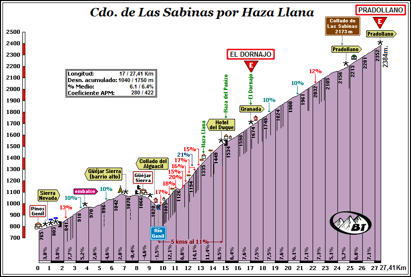
Let us look at the routes first, because once we're up to 2400m they're all the same anyway; before then, however, there are a number of routes to get to the summit. The Vuelta has thus far used three: From Granada to Pradollano on the A-395, from Monachíl to Pradollano by El Purche and the A-395, and from Monachíl to Pradollano via El Purche and the Collado de las Sabinas. The first "alternative" version is to climb the A-395 to El Dornajo and then go into Pradollano via the alternative route used in 2009. This gives
28,7km @ 5,8% to get to 2380m, which is more than solid, but is still a real tempo grinding climb as we are looking at fairly consistent gradient. What we're really here to talk about in terms of these routes is the side via Güejar Sierra. After all, you all saw the 2013 Vuelta. You are therefore all aware of the brutality that is inflicted on the riders between that village and El Dornajo via Haza Llana. Well, that road goes all the way up to the Collado de las Sabinas, and therefore it can be turned into an even more brutal mountain.
Yes, that's right, an almighty
27,4km @ 6,4% including more gradients over 10% than you dare shake your leg at unless you're really cramping up. That climb is going via the Collado de las Sabinas, so you could go as far as 2173m, then have the couple of km flat and the run-in to Pradollano and the Area Autocaravanas shown earlier, however that climb takes us to the Cruce that then would give us about 400m descending into the Area Autocaravanas to make a much more solid finale (this was the original planned finish for 2009 before they decided to take them through the town for logistical reasons). It also stacks up damn well against the
Tourmalet, and indeed even if you remove the false flat and descent around Güejar Sierra, you still have a definite ESP climb -
18,0km @ 8,0%. That's ESP in anyone's language.
It would also be feasible to use the El Dornajo climb to lead in to climbing the easier route, on the main road, but really I see that as quite pointless. Why would you take the harder route to halfway only to then make things easier on big wide roads and negate the chances of those slopes actually being important? Certainly the way Javier Guillén has been behaving of late would indicate that he agrees on this front. For the record though, here is a comparative graph of the two profiles between El Dornajo and Pradollano.
Of course, that cruce at 2384m still isn't even remotely close to the end of the climbing. That road is where the traditional route joins the Collado de las Sabinas road to become the all important road to Pico Veleta, the highest paved road in Europe. Here is a photo of the cruce, from Miguel Baéza and Martin Cerván, who have taken on all these beasts and are tougher than I am as a result.
Of course, the existence of this cruce is fantastic news for route designers because it means that designing some incredible routes through the Sierra Nevada is possible; climbing to Pradollano through El Dornajo and Las Sabinas and then being able to descend back to Granada, which allows us to do such brutal combinations as El Purche-Las Sabinas-Collado del Algüacil, or El Dornajo-loop back-Las Sabinas-descend through El Purche-Cumbres Verdes. A descent to finish on Cumbres Verdes would look like this, while another option is to only descend as far as El Dornajo and just climb the second part of the climb again, bringing the super steep stuff closer to the finish.