• The Cycling News forum is looking to add some volunteer moderators with Red Rick's recent retirement. If you're interested in helping keep our discussions on track, send a direct message to @SHaines here on the forum, or use the Contact Us form to message the Community Team.

    In the meanwhile, please use the Report option if you see a post that doesn't fit within the forum rules.

    Thanks!

Great "unknown" climbs

Page 15 - Get up to date with the latest news, scores & standings from the Cycling News Community.
Jun 30, 2014
7,060
2
0
Visit site
Re:

McLovin said:
https://www.youtube.com/watch?v=1dO77C3kYsw

Balea Pass (North)
25.8 km with 6% average slope. I climbed it for the first time this summer. It's not that unknown.
Yes, it's a great climb, I like to call it the Ceauşescu-Stelvio. :D
 
Refugio del Pilar
Location: Canarian Islands, La Palma Island to be more specifically. There are some ways to climb it and here are two of them:(you can see the images in that page of the thread, CN doesn't allow me to post pictures that are more than 1200 pixels)
http://apmforo.mforos.com/1304540/1...aurel-cabrera-y-otras-zonas-de-espana/?pag=12

The traceurs mostly use it after the Roque de los Muchachos as seen by here:
19vSantaCruzdeLaPalma-ElCharcoBrea-Galga-Barlovento-LasMimbreras-RoquedelosMuchachos-RefugiodelPilar2.png


vinadio_zps9onraoee.png~original


I have also made a stage that has Roque de Los Muchachos and Refugio del Pilar but my stage finishes in La Punta:
https://www.la-flamme-rouge.eu/maps/viewtrack/hd/107270
 
Re: Re:

fauniera said:
Forever The Best said:
I have also made a stage that has Roque de Los Muchachos and Refugio del Pilar but my stage finishes in La Punta:
https://www.la-flamme-rouge.eu/maps/viewtrack/hd/107270

I have made a similar stage, finishing at La Cumbrecita. ;)

d4QFCyG.png
Since imgur is blocked on Turkey I can't see your stage. But nice to know that I am not the only one in this forum who has planned a stage with this awesome climb :)
 
Ouro Preto in the state of Minas Gerais translates as black gold. Ouro Preto is a former colonial mining town located in the Serra do Espinhaço mountains and designated a World Heritage Site by UNESCO because of its outstanding Baroque architecture. In 1750, because of the gold rush, 80.000 people were living there, making Ouro Preto the biggest city in the americas.

Vista_de_ouro_preto.jpg


Pico de Raios

This picturesque city is home to an obscene bestiality that makes Koppenberg and Huy look like Scheldeprijs. The road up to the "Morro São Sebastião" ends at a zen buddhist monastery. :D Only 2,6 kilometers long, but with an ascent of 376 meters. This means we are facing a slope of 14,1%. The climb maxes at 23%.

And of course...it's on cobbles. Cobbles from colonial times. Cobbles to hurt everyone, put cobbles on your road to double the fun.

Easy start...
First ramp...
Don't look on beautiful churches, go right and suffer...
That's where the fun is...
Are you kidding me?!
TJ tweeting for his mommy...
Enough...Please.
Que beleza...

vgzAzaP.png
 
Jun 30, 2014
7,060
2
0
Visit site
I've decided to do a small series about the climbs around Bolzano/Bozen and maybe a bit later even about those around Brixen, one of my favourite areas to ride my bike, even if LS has already covered the Rodenecker Alm.

First we start with an ungodly seep monster, Oberbozen/Soprabolzano on the old road, the Magdalena Straße.
It's rather narrow and 200m would need to e repaved, but the first 3km put the Zoncolan to shame.
12_Begin_der_harten_Unteren_Magdalena_Strasse.jpg

15_Ob_St._Magdalena._Ab_hier_lange_Rampe_bei_25_.jpg

18_Teuere_Sanierung_und_Neutrassierung._Aber_die_Strasse_fuhrt_nirgendwohin._Die_Stadt_hat_zu_viel_Geld_.jpg


Just look at the Profile of the climb:
47382826_10205283152954166_7872076773213601792_n.jpg

You should have the climb end with 1.1km to go in the middle of the village, if you want to have a MTF there's a decent sized parking lot (it would be motobikes supporting the riders, just like on the Zoncolan) and with the ungodly steep parts righ at the start of the climb that could actually be a good MTF, but that's not the best option when it comes to using this climb.
There is a nice road that links Oberbozen with the normal Rittner Straße, so you could have a downhill finish in Bolzano/Bozen, or go all the way up to the Ritner Horn/Corno Renon, after a bit of false flat and a short descent we'd have the final 7km of this climb as an easier uphill finish after a really hard, ungodly steep climb:
RittnerHornS.gif


The Oberbozen climb can be linked with many other climbs before it. If you want the have a short stage after a Obereggen MTF or something like that, maybe even Meran 2000, you could go full Zomegnan and create something like this:
https://www.cronoescalada.com/index.php/tracks/viewTour/479759/247889
47689090_10205283148554056_8293486470237257728_o.jpg

I'll present the hardest of those climbs pretty soon in separate posts.
 
Jun 30, 2014
7,060
2
0
Visit site
Re: Re:

Cance > TheRest said:
Mayomaniac said:
I've decided to do a small series about the climbs around Bolzano/Bozen and maybe a bit later even about those around Brixen, one of my favourite areas to ride my bike, even if LS has already covered the Rodenecker Alm.

Spectacular climbs!

Do you know the climb to San Genesio Atesino from Bolzano?
Yes, it's one of the next climbs that I'm going to cover.
 
Jun 30, 2014
7,060
2
0
Visit site
Ok, let's start wih the next climb.
Next year the final stage of the Tour of the Alpes (still a horrible name) will feature the Salten/Il Salto climb before a downhill finish.
SaltoS.gif

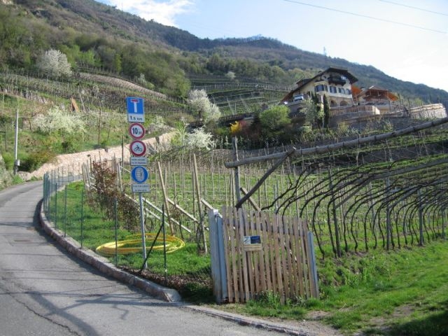
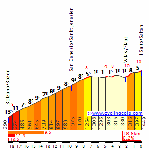
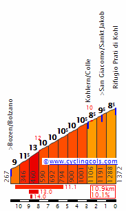
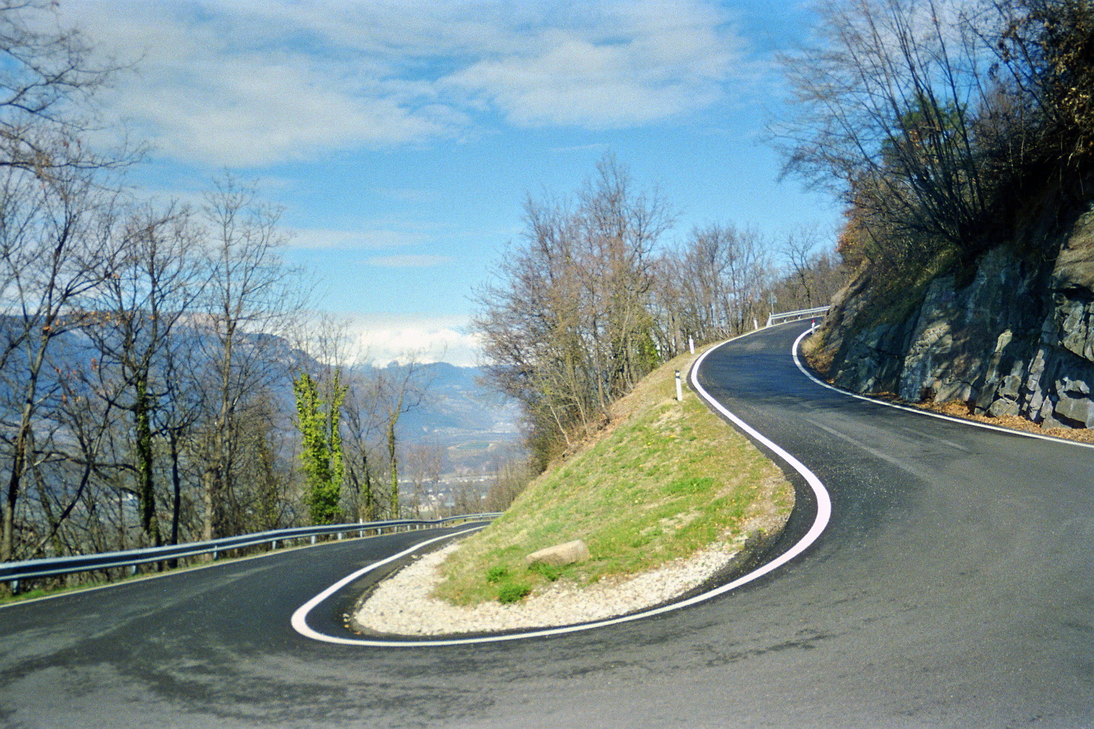
The first 7km of this climb can be replaced by the old road, the Alte Jenesier Straße.
It's not that narrow and the road is in good condition, but it's ungodly steep.
Those 7km are 
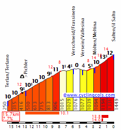
replaced by 4km at 15.7% with ramps up to 30%, once again right at the start of the climb.
06_Weiter_oben._Dieses_Stueck_brauchte_zwei_Versuche..jpg


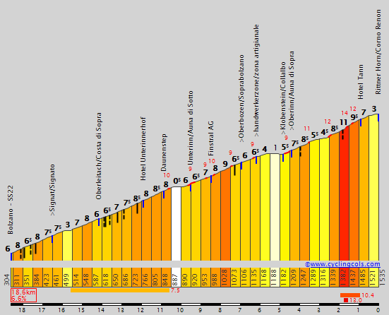
Let's take a look at the profile of the climb:
47575589_10205284092537655_7969138378358652928_n.jpg

47474392_10205284092777661_2127351173483593728_n.jpg

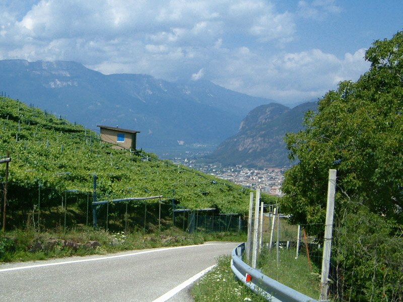
As you can see the climb mellows out after those 4km and after that we even have 5kkm that are slightly downhill before the final 2km.
You could have a MTF on top of the climb, there's the decent sized Schermoos parking lot that could host a MTF, the steep part would blow the race into pieces and the favourites would be on their own on the 5km that are slightly downhill false flat before the final 2km.
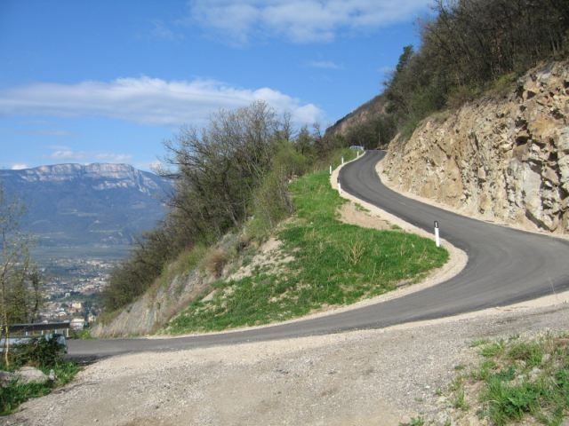
You can also play with the options that a potential downhill finish gives you, as you can see it's a rather steep road, but the Tour of the Alpes is using it before riding back to Bolzano/Bozen (a bit over 10km of flat) so why not?
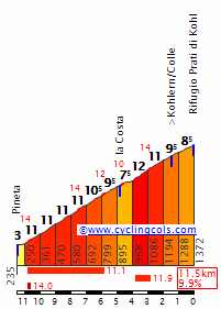
The downhill part of the climb:
SaltoN.gif

Here you could have a finish in Bozen, Meran or Lana with a flat section after the descent (+10k, around 10km and 5km respectively), or you could have the steep side of the Gampenjoch/Passo delle Palade from Vilpian/Vilpiano right after the descent until the crossroads to Lana and have a downhill finish in Lana right after the descent, that would probably my favourite option.
It's this climb unil Lana:
PaladeNE.gif

Of course i's really easy to put a few climbs before the Salten climb to make the stage hard enough to make the race explode on the steep section.
A hard stage starting in the Val Badia, maybe after a Kronplatz/Plan de Corones MTF, and finishing in Lana could look like this:
https://www.openrunner.com/r/9362607
 
Kaunertaler Gletscherstraße

Not too steep, but climbing from 866m to 2750m over 38.5 km's isn't exactly a walk in the park either.
A bit after halfway you get a welcome 6 km flat section next to the lake, lowering the average quite a bit.

Absolutely stunning scenery, one of the most beautiful alpine roads I know. The start of the climb is about 60 km's away from Prato Allo Stelvio.

Average grade: 4.9 %
Length: 38.5 km
Altitude start: 866 m
Altitude top: 2750 m
Ascent: 1884 m

Kaunertal_Prutz_profile.gif


GOPR0600-1534092374379-high.jpg


GOPR0604-1534093676004-high.jpg


gletscherstrasse_pano_1.jpeg
 
Jun 30, 2014
7,060
2
0
Visit site
Now we have te most "normal" hard climb around Bolzano/Bozen, Kohlern/Colle on the Seitner Straße (you can thank Tolomei for that super accurate translation...).
The climb is pretty steep and can be used the pass, on the following profiles the climb ends with 1.5km to go, there is a small parking lot on top at the Schneiderwiesen Hütte, but it's not big enough to host a MTF.

from north:
PratiDiKohlN.gif

from south:
PratiDiKohlS.gif

Both sides of the climb are near the 10km at 10% area, so we're talking about hard climbs.

Most of the road is in a pretty good state, it gets a bit narrow towards the top, but it's still fine.
Let's take a look at the road:
4_Kurze_Verschnaufpause_orig.jpg

D-0018-auffahrt-kohlern.jpg


What can you do with this climb?
The obvious thing is to use it as the final climb before a downhill finish in Bozen (southern side of the climb) or Leifers (northern side) and the southern side of the climb could also be used to wear the riders down before monsters like the old road to Oberbozen or the Alte Jenesier Straße.
To sum things up, it's a great climb that could be used without any problems and maybe the race formerly known as the Giro del Trentino will actually use this one in the next few years?
 
Jun 30, 2014
7,060
2
0
Visit site
Yes, there are many great climbs in that Area.
I've already talked about the Nigerpass/Passo Nigra in this thread, so 'll probably start talking about some of the climbs around Brixen/Bressanone, even if LS has already covered the Rodenecker Alm/Alpe di Rodenego.
 
About Rodenecker Alm/Alpe di Rodenego... If this is the only entry here (i've also checked his Merano 2000 stage) it seems ether i'm blind or he missed a 3rd side of Rodengo. It starts just before Luson in a little hamlet that's probably called Preisn. On Google Maps the road is called Kreuzenberg. This side is sort of a half-Mortirolo with (my own estimation) 7,7km at very regular 11%. This side directly reaches Rodengo without the need of riding on a plateau.

Other worth mentioning tracks are a narrow, parallel side of Passo Resia via Alsago/Alsack, Tanas starting from either Sluderno/Schluderns, Lasa/Laas or Silandro/Schlanders. Three sides of Kieneralm (Forcella delle Cave?) north of Rio Pusteria, a narrow but beautiful side of Eores starting from Chiusa/Klausen, very mainstream but i seems a little bit underappreciated Maso Corto/Kurzas and of course San Valentino Di Sopra/Obergummer (also 3 sides).

Good luck chasing them random Italian muritos even if Alto Adige is not particulary "unknown".
Limosano, Via Maiella; Schiavi di Abruzzo; Torrebruna etc. Go for Molise. It's basically a copy of Portugal... you will have way more fun tracing local, often very steep roads approaching strong cat. 1 or even low HC than this commercial, mainstream stuff.

Btw, sorry for a rather barebone post, but lately i'm struggling with time. Maybe if i will have a bit more of it (definitely not this year though) and i won't be slacking then i may do a more comprehensive view of Molise (mainly the Molise/Abruzzo border).
 
People know North American climbs at crazy high altitude like Mt. Evans and Pikes Peak, but this is to go even further beyond!

Hwy 27 - Atacama, the highest paved road/Pass on the American continent, topping at over 4,7500m of Altitude in Northern Chile:
https://www.cronoescalada.com/index.php/puertos/view/16544
83233723_10206930021444849_8577371816954167296_o.jpg

atacama-desert-chilean-road-route-27-chile-picture-id1130749272

4342510026_616ac96df6_b.jpg

The steep part is pretty much the Stelvio from the hard side, but it starts at over 2,500m of altitude.
This one is relentless and exposed to the wind, with pretty much no shelter, but the wind is usually a tailwind/crosswind, so it wouldn't hinder action.
So, how could you use this one?
The first option would be a straightforward MTF.
83384377_10206930070526076_739021046799138816_o.jpg

The 2nd option would be even crazier, you'd have this monster right at the start of the stage and then 100km at over 4,000m, up to 4,800m on rolling terrain with the finish at Paso de Jama, right at the Argentinan Border, total madness and something like that is probably never going to happen.
84475907_10206930080846334_6531387875475324928_o.jpg
 

TRENDING THREADS