Steven Roots said:
No problem, you're welcome !
In fact, i think in a way, we're just complaining, and rightfully so, i think, considering the abnormally low number of times we've seen these climbs.
If they were deep in the mountains, away from the civilization, its understandable, but there is absolutely no logical explanation about why these 3 have never been featured in more than one single Tour.
As it is a thread designed for our own designs, i feel its obvious that eventually there will be a sort of consensus about several names, especially ones that stands out from the vicinity.
Libertine Seguros said:
Also, it's worth noting that as many of us share the same opinions of what makes a good route AND what is underappreciated and/or underused, you will end up with certain climbs that are "overused" in traceurs' projects. We also often share opinions on what is overused and what we therefore are seeking to avoid because of it being predictable, which often sends us in the same directions trying to avoid them!
Spandelles is another one you could point out, and possibly Bagargui as well. The other thing is that for the most part a lot of the traceurs have moved away from the "test the limits of possibilities" approach (although it is still fun to find out occasionally what crazy climbs or hell-pavé is out there) towards less extreme approaches that tend to focus more on what would actually be viable for real-life race organizers, with finishes in towns and/or at mountain locations such as sanctuaries and ski stations large enough to host at least some level of bike race... therefore we can see some repetition on what can be done as people seek out usable finishes for real-life underused climbs that they want to see and often come to the same conclusion. I mean, at one point I published a Vuelta stage, and when searching for a profile of a climb I'd used in a different stage came upon a fantasy route designed by visko (who occasionally posts here) at PRC which had an identical stage to mine (over Collado Canseco, Haza del Lino - another traceur's favourite - and Conjuros to finish at Motril). There's also the issue of anybody who tries to design a Deutschlandtour (which has included a number of goes at a GT as well as the shorter version that ties in to the real event) trying to work with the Berchtesgadener Land because it has the hardest climbs on German soil, for example.
I'm shocked that even Libertine answered to that silly remark. I just won a life

. The arguments are of course perfectly logical. The race designs are 100% subjective and if going into at least partial realism and using regions neglected by the real race then it can end up in wondering with the same stages. I do know that and i have no issue with that. No problemo.
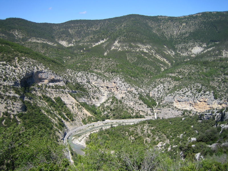
Region around Sallanches is very nice and feels slightly underused with La Flaine/Col de Pierre-Carrée - borderline 1/HC, Passy Plaine-Joux - a 1C small, very nice station with a lot of parking space, le Bettex - thankfully used in Dauphine this year, 2009 combination of the Romme - Colombiere, and of course the 1980 WC that now has legendary status. Gap and the Durance valley are fine too with a bunch of 1C climbs - Les Orres, Côte de Pallon (3 Cat.), Puy-Saint-Vincent, Orcieres-Merlette, Chaillol, Noyer - Superdévoluy combination that are open for an easier medium mountain/mountain stage after some hard, regular alpine stage and i feel like slightly underused (i do admit that i've seen Moissiere & even Gleize). Of course the problem with aforementioned climbs is that they are quite hard to link with other climbs, that's why i think of them more as a Vuelta stages rather than Giro. Of course i didn't took into consideration the space available in the finish and the road quality on some of the passes (Moissiere, but still it looks better in terms of quality than Spandelles).
Steven Roots said:
As you said, though, around Bellegarde-sur-Valserine there is a nice playground, and the horror that was the 2012 stage just pushes the forgotten ones even more to the spotlight.
TdF is so big, that it would have problems with other possible finishes. I feel that Grand-Colombier is very unluckly located. Sadly, the 2012 was just very dull in terms of racing, and Sky's approach didn't help it at all. The real problem i have with 2012 TdF is the Foix stage. I think you know, what issue i can have with that particular stage. Back to the Grand-Colombier. There's what i do feel about this beautiful climb; wrote that in the "Not Official: No Galibier and telegraphe in le tour?" thread.
dpm1991 said:
The problem with the Grand Colombier is such that there's no reliable finish that could handle the blood/money-sucking vampire that TdF is. The closest places that could handle the stage are the 2012 finish - Bellegarde-sur-Valserine and maybe the 2012 Dauphine option - Rumilly. I'm not sure if TdF ever hosted a stage start or finish in Rumilly, but it can definitely handle the Dauphine. Maybe Culoz could handle such stage (at least in the Dauphine), there are some parking lots on the Avenue Jean Falconnier. Maybe guys from CIAT & Carrefour could lend their precious space for couple of hours. There is some tiny parking on the Rue de la Roseraie. Maybe it could be big enough [to use].
Of course i'm no traceur, so maybe Libertine Seguros could make me hope in the Biche - Grand Colombier worlds destroyer. I feel, that this climb or combination is very good in the middle of the stage to change the stage status from maybe suspicious to definitely suspicious. It's of course not about the attacks, but the domestiques. In this year Chaussy did the job almost perfectly. The bunch of flat kilometers after it is a mystery for me. I wonder, what would happen if there were no flat after Chaussy.
Steven Roots said:
For your problem, i feel that given the length of the loop (under 6km), crossing it would cause trouble.
But there might be a solution : the trainstation is just nearby your finish line. You'll likely have some parking space there.
Thanks for the answer. I was not looking into the parking lots. It was just an example.
Ok, I am too much trash-talking here and it is a great thread. So I will try to contribute to it. I have a loose stage, that maybe could work out in the l'Avenir. I'm not sure, as the finish is very tiny. I will try to present the stage as best as i can.
La Mure - Station de Céüse, 120km, ~3100 asc
climbs:
Col Accarias - 9,5km, 3,1%, 3 Cat. 892m
Col de Saint-Sébastien - 4,3km, 4,7%, 3 Cat. 983m
Côte de Chaillolet - 7,6km, 7,4%, 1 Cat. 1540m
Col de Manse - 6km, 3,5%, 4 Cat. 1272m
Côte de La Freissinouse - 5,3km, 4,4%, 3 Cat. 982m
Station de Céüse - 6,6km, 8,3%, 1 Cat. 1520m
start: La Mure, Route Napoléon/Place du Docteur Bethoux
km0: Ponsonnas, Route Napoléon, 3,3km from the start
finish: Station de Céüse, Parking
sprint: Corps, Route Napoléon, ~80m straight, 3km, 5,5% uphill (borderline 3 Cat.)
feed zone: Poligny, Route Napoléon
Start of the stage is in
La Mure, a small town over the Drac valley. The region is very friendly for cyclists as there are lotsa hills and climbs with the standing out Col de Parquetout and interesting Station Saint-Honoré (sadly, there seems to be no space for a real stage finish in eg. Dauphine at all). The start of the stage will be propably on the well known N85 Route Napoléon just where it crosses with Place du Docteur Bethoux.
Guys will then go around the town to the km 0, that will be on the N85 in Ponsonnas 3,3km from the start place. In La Mure peleton will pass by Avenue Chion Ducollet. Then on the Place du Theatre they will turn slightly right into a dark and climatic Avenue de la République. Next they will turn left to the Boulevard Paul Decard and then by the outskirts of La Mure - Rue Albert Luyat, Boulevard du Stade and D168 Boulevard des Trois Saules to reconect with the N85 Route Napoléon.
After the km 0 peleton will turn into D526 and will descend to the bridge over the Drac river. They will keep to go on D526 entering the first climb of the day -
Col Accarias. This climb is two-stepped. First part, to the Saint-Jean-d'Hérans is the steppest part of approximately 4,5km, 4,9%. After Saint-Jean-d'Hérans the climb is clearly letting go with being just a 2-3% false flat. The whole climb is approximately
9,5km @ 3,1% that is a borderline 3/4 cat. I decided to promote it into a 3rd cat to promote the aspiring
tete de la courseurs with more than just a tiny point.
The descend will direction the pack to Mens, where they will turn left into D66.
Mens is a small town that looks like thousands of small towns in France with its narrow streets and middle ages like architecture. After Mens peleton will start immediately climb up to the
Col de Saint-Sébastien. It's a type of climb that gets progressively difficult with last 2kms being around 6,7%. The whole climb is approximately
4,3km @ 4,7% - that is another borderline 3/4 cat and as the last time - this climb is categorised as a 3rd cat.
After the col peleton will ride through a plateau just above the Drac river passing some villages like Cordéac. Then they will descend into Lac du Sautet with the town of
Corps looming on them. They will join the D537 and after passing Barrage du Sautet will start an uphill drag into aforementioned Corps, or as TdF wants to call this hill - Rampe du Motty. In the town of Corps(es) there will be a sprint on the N85 Route Napoléon. This is the 2nd time we are rejoining the famous N85 and it wont be the last time. The
sprint will be on a straight of around 80m, after around
3km, 5,5% uphill stretch that would be yet another borderline 3/4 cat. If it would be a categorised climb, then it would have a 4th cat, because there are too many 3rd already and the universe needs its harmony.
Peleton now will go back for good to the N85 passing the Rampe du Motty going along the Drac river passing near some villages and passing by Chauffayer. On the N85 the feed zone will be situated, near the village of
Poligny and will end just as guys will turn left into D945 breaking out with the N85 for a longer time and will pass by the Drac river in the process. After passing the river road goes up immediately as the bunch will enter
Saint-Bonnet-en-Champsaur and the next climb in the process. This little town has a history dated as old as 10th century with being quite prominent in the renaissance era. It sadly did not evolve into a bigger city. We will of course bypass the main town following Rue de la Corniche, Route de la Motte and Avenue des Droits de l'Homme, as the roads in the town are as narrow as a human hair.
After passing Saint-Bonnet-en-Champsaur we are heading into a road that connects D43, that leads straight into Chabottes with the Chaillol route - D143. The road is luckily not that narrow as i asumed, being around 1,5 car wide. Asphalt is not in the worst condition either - seems to be quite fine. This road leads to the
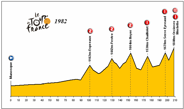
Chaillol 1600 station going uphill almost all the way. The climb is a steady grind between 7 and 9% and never goes more than 10% clocking the max. slope at around 9%. It's a very classical 1 cat. climb being medium lenghted with average slope being over average. We won't go to the station itself, we will turn into Chabottes near the station in a place called Chaillolet - that's why it's called
Côte de Chaillolet. The climb is of course 1st cat, clocks at about
7,6km, 7,4% and interestingly was featured on the 1982 TdF 15th stage to the forgotten Orcieres-Merlette station.
The bunch will descend into
Chabottes and then go pass the Drac river, that seems to have even stronger bromance with us than the N85 (spoiler: it's the last time we will se this river), and join the D944 Orcieres Route. After 3,5 to 4 flat kilometers the well known and overused
Col de Manse will start. This time we tackle the obscure north side, that didn't feature that much on either TdF or Dauphine. The road is perfectly fine, resembling the Chaillol road in its wide and slightly better quality. The climb in its profile is similar to the Col Accarias - begins quite steepily (2km @ 5%) to progressively let down as low as 1-2% in the way. The whole climb clocks at around
6km, 3,5% and is a 4th cat.
The stage now is on the pure TdF soil, as it continues down into
Gap alongside the D944 route, rejoining the very moody
monsieur Napoléon in the process. This rute saw Condador kabooming in 2011 with Sanchez and Evans. The descend will end in a well known city of Gap. It is perfectly located as the gate to the alpes, it's no shocker that TdF was here so many times. We won't go to the city center. The riders will bypass it folowing the Rue des Champsaurins (look out for a bad quality asphalt, but it's just a 100m stretch), Rue des Jardins passing by the Torrent de Bonne torrent/brook, Rue de Camargue and Rue Jean Macé to join the D994 highway, passing Parc Saint-Joseph in the process.
Now the stage will split the path, as the regular one is just to go by D994 but i'm thinking about going by the old road known as
Ancienne Route de Veynes - the same trick that was used in this years TdF with the Route de la Descente up the Col de Manse. It's a very narrow, one-way, around 1,25 car wide road if you include the sidewalk that is blurred with the actual road. Here's an excerpt from the Streetview how the road looks like.
It's definitely not the worst thing i ever saw. Grand-Colombier has about the same width. This road is about 600m long, goes parallel to the highway and is of course steeper & shorter than the highway route. For the security sake - there's no descend on this road, it's just uphill. After this
chemin rejoins with the regular highway we are going still uphill into the La Freissinouse. The climb ends around the intersection with D503 and is stedy at around 3-5% with a 1km @ 6% being the steepest. It featured very often in the TdF but mosty from the other way, where it's just a little bump. Last time it was riden from this way was back in 1996 in the 11th stage from Gap to Valence but it seems to be uncategorised (there seems to be no footage nor information about the first kilometers of this stage except the location of the sprint in La Roche-des-Arnauds). The climb seems to have no name or it is well hiden in the depth of the Internet, so I decided to call it
Côte de La Freissinouse as La Freissinouse is close to it and i won't call it Côte de Gap. There are some sections called Malcombe, La Garde or Les Barrets that it can be named after. The climb itself is a 3rd cat. at roughly
5,3km, 4,4%.
Now after going over the enigmatic hill guys will fly by the La Freissinouse and will turn left into D118L - just a country road passing by the Manteyer village. It's quality is quite fine with what seems a fine asphalt and 1,25 to 1,5 car width, with the bridge being the tightes place - just over 1 car width. I've included this road to shorten up the run in to the last climb of the day. Alternatively you can go along the highway to La Roche-des-Arnauds and turn left into Céüse route - D18. The bunch will go along the D118L - then D118 - as long as they will reach the crossroad with the D18 where they will turn left. There starts the last climb of the day.
Station de Céüse is a small, beautifoul station located in what looks like a natural amphitheatre, sorrounded by the Céüse range with the Pic de Céüse (2016m) being the highest in the region. The site is in the Natura 2000 network, where you can ski and practice mountain climbing. Sadly i don't understand the French language, so i won't say much about the station itself. I have a weakness for those small, quiet and uninterupted stations. Prefere them much from the concrete walls of overblows like Cervinia, Sestriere, Alpe-d'Huez, Tignes etc. The quality of the road is very nice, with really fine asphalt and at least 1,5 car wide. Sadly, there's little to no space in the station itself, so even a small race will encounter logistical problems.
Back to the stage. The climb is similar to the Côte de Chaillolet. It is a 1st cat. climb with parameters of
6,6km @ 8,3%. The climb can be devided into two parts. The first 4kms are steeper at around 9,5% with the max slope of 10%. Last 2,5kms are constantly at around 7%. The road has classical alpine serpentines in the first half, while the second part is more irregular - Pireneyesque like. The stage finish will be in the station on the tiny turnaround/parking lot.
Now to sumarise. This stage is most propably unrealistic as the finish is too small, but the rest of the route with maybe even Ancienne Route de Veynes seems to be perfectly fine for a Dauphine standard, maybe even TdF as the descends are not that dangerous and this year there was Col d'Allos. The stage has 3 cat 3, 2 cat 1 and 1 cat 4. There are around 3100m uphill that are significant, this would propably classify the stage as medium mountain. It might be pulled out in something like Tour de l'Avenir or similar after let's say a classic
traceur stage to La Mure with Morte and Parquetout included, but the logistic problems would be propably horrific.
How this stage will be riden? Propably very classical way even for the amateurs/half-professionals. A chaotic beggining with the 10-15 men breakaway establishing on the flat after Col de Saint-Sébastien. Then favourites checking the breakaway at about 2 mins to begin pulling it back on the Côte de Chaillolet with domestiques
swelling out one after another as the stage will progress. The breakaway propably will be caught just before the final climb or on its first slopes. Meanwhile the race will explode on the first 3 kilometers to i hope 1 vs 1. The last 2,5kms will be used to hold on or even expand Froome-style the differences. I predict the differences to be at around 1:30 from 1st to 10th.
That was just a loose stage that is not a part of a bigger project. It's just a stage. I hope i presented it well enough to entertain you guys and my english wasn't too bad. And please as i will leave a reminder to myself: get a life, as this post just took out 10 hours of your life.
@Steven Roots
Stage 10 : Beaufort - Col du Granon, 245km.
I don't think the Zomegnan approves meme is enough for this monstrocity. I think the only guy that would be jumping like a kangaroo at the sight of this stage would be this troll: