Race Design Thread

Page 223 - Get up to date with the latest news, scores & standings from the Cycling News Community.
On day 2 we enter much more uphill terrain...

Tour de Pologne
Stage 2: Zielona Góra - Szklarska Poręba (171km)

yYXnaUx.png

k6gcGoE.png


It's the also the first uphill finish of my race. Though there are two cat. 1 climbs, I consider this to be more of a prelude before the harder stages, the first of which comes the next day (hint, hint).

This stage starts in Zielona Góra. This city - the name of which translates as 'Green Mountain' - is famous for wine production, which has been around since 1314 (though now there are no operating factories). Nonetheless, there is a yearly wine festival there. We start on its beautiful old market, which is covered with cobbles.
GeP5VAl.png


km0 comes after a 3.2km parade, just west of the city.
nJa6QwY.png


From that point onwards, we head south, deeper into the Lubusz region. The first intermediate sprint is held in Żagań, known for its military proving ground (highlighted in red on the map) just south of the city. The second intermediate sprint comes in Lubań, a larger city in the Lower Silesian region. It has some very old buildings and monuments, including a 1318-built fortified tower.

And then we enter some rolling terrain. First, we have a cat. 1 ascent to Rozdroże Izerskie. Though I say on the profile that the road is 7.2km long, it actually goes uphill for about 15km. The ascent isn't tricky, and only averages 3.5%, and has a maximum of 8%, but its the length that allows me to give it the highest category.

The descent, though, is tricky. It features numerous hairpin bends on a narrow road, and is quite steep, too.
djtLWSK.png


This is followed by the final ascent to 'Szklarska Poręba'. In reality, we start climbing just before the city, pass through it, and continue onwards, towards the Polana Jakuszycka, home of cross country skiing in recent years - it hosts the annual Bieg Piastów and has even seen the World Cup in CC skiing twice.
b2DlCAg.jpg


The climb to the finish averages 3.1% (including a short downhill) and reaches 9%, so again not too difficult. It is, however, 13km in length.
TczmKCA.png


The finish line is drawn outside of the ski stadium, on a wide two lane road.

Like I said, this stage isn't particularly hard, and almost definitely will not result in major splits. It will probably end in a sprint from a group of puncheurs/GC favourites - something like Ulissi's win in stage 1 of TdP 2013 (though I'm not comparing Jakuszyce with Madonna di Campiglio :D )

Tomorrow, though, is where the difficulty starts (I may try and post that stage later, in the afternoon).

Maps taken from openstreetmap.org
 
Heh, a Nordic ski stadium with biathlon range. Thumbs up from me for that.

Stage 5: Vitória-Gasteiz - Portugalete, 161km

ixegb9.png


jkwnyh.png


GPM:
Alto de La Avellaneda (cat.3) 1,7km @ 5,5%
Puerto de Las Muñecas (cat.2) 4,3km @ 6,8%
Alto de La Helguera (cat.3) 1,9km @ 6,9%
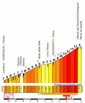
Alto de las Peñas Negras (cat.1) 7,6km @ 6,2%
Alto de Cadegal (cat.2) 1,5km @ 11,3%
Alto de Argalário (cat.1) 8,7km @ 6,1%
Alto de Cadegal (cat.2) 1,5km @ 11,3%

The penultimate stage of the Vuelta al País Vasco sees us shift from Álava back into Bizkaia and the Bilboko Itsasadarra, otherwise known as the Ría de Bilbao, or Estuary of Bilbao, as we head for a stage which finishes with a few of those tricky climbs which overlook the cities along the southern bank of the Nervión as it reaches the sea. This is the last chance for the climbers as, as is tradition, I'm ending the Itzulia with a contrarreloj.

vitoria_gasteiz.jpg


Uncategorized ascents are the order of the day for the first part of the stage as we head from the higher plateau on which Gasteiz sits and head down towards the more conventional low-lying mountains of the majority of Euskadi. We travel there via Aiurdin, a formerly important mountain pass that has now been bypassed by the autovía and therefore is a relatively inconsequential quiet climb from this, its easier side. From this, we then descend via the Puerto de Altube to the lower altitude part of Araba, around Llodio and Amurrio. There is an exclave of Bizkaia if we turn back to the south after this descent, into the town of Orduña which of course gives its name to one of País Vasco's toughest climbs, however here we're leaving the tough climbing until later, instead going through a series of uncategorized ramps and repechos as we pass through Amurrio. Although the town hasn't hosted its regional Tour since 2011 (the start of the Arrate stage) and a stage finish hasn't taken place there since 2010 (when Francesco Gavazzi won the nearest thing to a sprint stage in that edition), these repechos will be familiar to the riders from the run-in to the nearby Garrastatxu climb in the 2016 second stage which was won by Mikel Landa. Obviously there, these repechos were not the important part of the stage as they were finishing on a traditional Basque puncheur hell (more of that later) but nevertheless this should give the riders an idea of what they're doing.

Aerea2.jpg


From here we cut through further rolling terrain via Okondo towards Sodupe and Güeñes, the latter of which being well known to the race. Unfortunately it doesn't have the best of records; in 2009 it was the finish of a fairly benign stage where Astana let the break go, and the stage was won from the three-man break by known user of racially abusive terms Michael Albasini ahead of Jürgen van den Broeck and Christian Vande Velde - unsurprising when you consider the trio that Albasini would have the best finish, really... it then hosted the start of the penultimate stage to Zalla that year which was won solo by Marco Pinotti a few seconds ahead of a reduced bunch. The race returned in 2012, with the first stage being a similarly relatively uninspiring loop around the town which was won in a reduced bunch kick by known admirer of Franco José Joaquín Rojas (presumably a chance to belittle the Basques on their home turf was a motivator for him since he wins approximately once per Scott Walker album release) before the second stage, from Güeñes to Vitória-Gasteiz, was won in similarly uninspiring style in that rather disappointing edition (save for the Oñati stage, where the secret final climb salvaged matters) by Daryl Impey.

Now, then, the climbing begins. It starts fairly easily with La Avellaneda which won't drop any rider unless they're sick or hurt, because the kind of rider that can't get over a climb like that won't even enter the Vuelta al País Vasco - it would be entirely pointless to do so. After the descent into Sopuerta, we have a rare excursion of the riders into a neighbouring province... while the race passes through neighbouring Nafarroa every year, and at times also into the bordering areas of France known to Basques as Iparralde (literally "the north"), these are pretty much accepted as within the boundaries of Euskal Herria to those adherents of the Zazpiak Bat line of thought; indeed while linguistically Euskera may have lost a lot of its currency in many of these areas, many of the cities, towns and villages in these regions consider themselves Basque and show pride in that cultural heritage; the race typically sticks to those parts of Navarre on the Basque side - Leitza, Lekunberri, Alsasua, Etxarri-Aranatz, Dantxarinea and so on - anyhow. The race does head into the exclave of Burgos that is the municipality of Treviño most years as well, although as that area is entirely surrounded by País Vasco it is not surprising. It is much rarer to see the race actually head into the neighbouring Comunidads of La Rioja and Cantabria (although in the Valle de Karrantza stage in the 2007 race they did pass through Cantabria briefly) or the wider part of the Provincia de Burgos (unless going over the Puerto de Orduña which again allows them to briefly pass through).

In the final stage of the Emakumeen Bira in 2016 however, the women's bunch went through - briefly - Cantabria, to take on a less well-known Basque climb, and that's what I'm doing here. With gradients of up to 11% and no respite after its initial ramps, Las Muñecas is a solid 2nd category climb with scenic views into the shoreline area of both eastern Cantabria and western País Vasco.

6886218.jpg


Whereas the women descended all the way to the coast and then returned to País Vasco, I'm taking them via another short climb (the cat.3 Alto de Helguera) before descending to Ontón and heading back into the race's home region via the uncategorized Cota El Haya (although from that Emakumeen Bira profile you can see it's 1,6km @ 5,9% so not to be sniffed at, though relatively inconsequential here given there is serious climbing to come). After this we head to Muskiz, a town which sadly dots this pristine countryside with an unsightly refinery, a legacy of the difficult relationship of País Vasco between its beautiful scenery and its mining and industrial prominence. But from here on in, the stage gets going properly.

muskiz.jpg


The climb of Peñas Negras, also known as La Asturiana to add "clarity" (it prevents it being confused with Peña Negra, which is in Ávila province, but it isn't actually in Asturias, obviously) crests with around 55km remaining and is our first cat.1 test of the day. Its statistics are reasonable but the profile shows that it is a very similar climb to the one to the Santuário de Arantzazu that we took on on day 2; the first half of the climb is much more severe than the second; the first 3km average 9% and include the most savage ramps - with a maximum of 15%. The second half of the climb, however, is mostly false flat, with the last 3,5km averaging just 4%. The climb is a stopoff point at a former mining area which lies above La Arboleda, a mini-valley around La Reineta that has hosted the Itzulia recently, going via the other side of the climb and finishing at those steep ramps at La Arboleda. If I remember rightly they actually went by this inconsistent side direct from Muskiz, which is parallel to the climb we take, but I wanted to illustrate the descent section from Peñas Negras to La Arboleda. Anyway, that stage was in 2013 and was won in a Colombian duel between Sergio Henao and Carlos Betancur. The climbs around here are known as being part of the Valle de Trapagarán, and the town of the same name at the foot typically pays for the finishes in the small complexes up on the mountainside - in addition to that stage, they have also seen the Itzulia head into town in 2000 and 2005, with Danilo di Luca and David Moncoutié the respective winners.

reineta--490x578.jpg


9ffdf6f79781816e119717a25b91ee54o.jpg


Probably the best known climb around here is the Subida a La Reineta, a short-to-mid-length and consistent climb which is also taken via a funicular, probably the most well-used one in the region other than the Artxanda funicular in Bilbao itself. We will be descending this side however it was descended - twice from different sides - in the first stage of the 2010 edition around the port town of Zierbena, where Alejandro Valverde started laying traps in uncategorized climbs and they put two minutes on Samu right from the word go. Therefore more experienced riders in the bunch should know what to expect here, however I have sneaked in a little treat afterwards, in the form of a sharp left in Trapagarán and then a short but absolutely brutal ascent called the Alto de Cadegal.

272dd364.jpg


Although that image makes it look like sterrato, I can assure you this is tarmac. Here's another angle. Finding the correct profile is quite hard, however, mainly as with multiple summits nearby to one another the routes can cross over one another and get confusing. For example, the best profile I have for Cadegal is that it is the first 1500m of this side of Argalário - however there they then turn left after the village where I turn right, so they then rejoin (at the cruce for Trapagarán) the road that my péloton just descended, so I don't want to do that. Instead I turn right and descend into Gallarta, then across to the coastal town of Santurtzi, with a scenic park and its urban spread under the shadow of Monte Serantes, which keeps a permanent watchful eye over the Ría and the town.

2219239254_6d4683cc02_z.jpg


Here, we head along the coast road before taking on the final repecho to the finishing line in Portugalete for the first time. We take a slightly more tricky route than the girls in the final stage of the 2016 Emakumeen Bira when Ash Moolman tried to grab a few seconds. The finishing ramp is just 800m long and averages around 5% so just about enough for some punchy fighting given there will be no frontline sprinters on the line at the start let alone at the end after these climbs.

34o4vtx.png


Portugalete is of course most famous for the Puente Vizcaya/Bizkaiko Zubia, the enormous transporter bridge that dominates the river at this point; we will not head directly past it though it will loom heavy in the riders' eyeline for much of the way from Santurtzi to Portugalete; much as I'd love to send the riders up Santa Maria Kalea, we have to be realistic.

5.jpg


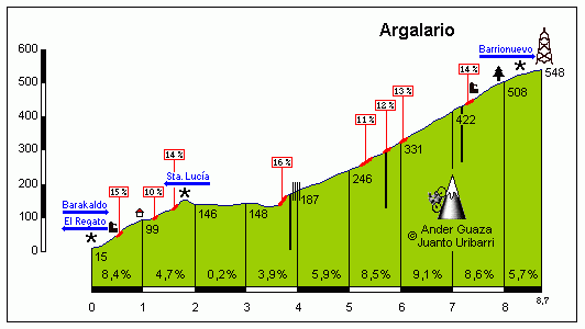
When the riders cross the line the first time, there remain 34km. The first few are flat as we head to the outskirts of Barakaldo, a Bilbao satellite town that hosted the start of stage 4 in the 2012 Vuelta, the MTF at Valdezcaray when Valverde crashed in the crosswinds and Sky, who had thrown a temper tantrum about Movistar not waiting when Levi Leipheimer - not a Sky rider nor the race leader - crashed in a descent under pressure from Movistar's fast descending teamwork in Paris-Nice, got on the front to distance him, creating some friction (Movistar had not been similarly angered when OPQS - who Leipheimer rode for - did the same thing to him in Catalunya, but Sky's sanctimonious behaviour in March followed by not practicing what they preached created some anger despite the fact that Abarcá pretty much never wait in such circumstances). From here, we take on the last cat.1 climb of the race, a surprisingly little-known ascent called the Alto de Argalário. There are a few sides to this climb, whose summit lies to the east and a little above La Reineta, and therefore it can be accessed quite comfortably by races. And the views are incredible.

Argalario.gif


7047981.jpg


The side that we're climbing, as you can see, is splendidly Basque, that is to say massively inconsistent and with some horrible ramps, maxing out at 16%. Cresting just inside 20km to go, this is a great place to make moves and carve the bunch down because there's very little respite to bring those moves back in. After the flat section, it kicks straight up to that 16% ramp and then so begins around 3km at a little under 9% with a few ramps getting up to 13-14%. This is like sticking Arrate on top of a short 2km sharp climb with very little respite, except there's no flat section. Instead we get to descend straight away to La Reineta via the last 3km of this, then to Trapagarán via the conventional side, before taking on that short sharp and brutal climb to Cadegal again, this time topping out with just 8km remaining; those 20% slopes will see this break apart for sure. Then we descend down to Santurtzi and have our final repecho into the finish at Portugalete where some tired legs will be glad for the rest. It turns out that the mountains overlooking Bilbao have a lot more to offer than the Itzulia ever lets them, you see.

PatxinF4.jpg
 
Re:

mikii4567 said:
[...]
Tour de Pologne
Stage 1: Szczecin - Gorzów Wielkopolski (161km)

9iyNc7D.png

emeK3Mj.png


[...]
And then we come to a very delicate matter - circuits. Many people dislike them, claiming them to be boring. And I too am an opponent of spending a flat stage doing 50 loops of a town in the Silesian metropolis. However, having a short one to be completed thrice is OK for me - it gives the fans an opportunity to see the peloton multiple times and engages the cities to bring the race over. Therefore, today, we end with three laps of a 5.3km circuit.
zV86Dmr.png


The finish is on a nice, flat and wide road, so it's clearly a day for the sprinters.

Tomorrow, we enter hilly terrain.

Maps taken from openstreetmap.org
Love your maps. Did you make them yourself or there's a specialistic site that makes such maps? I actually hardly remember openstreetmap but i don't think it has such build in track presentation possibilities.

Actually Gorzów is located on a moraine so there's no need to go all out pan flat unless you wanted it. I think your lap can be tweaked by including Walczaka street which has like 500m at 6-7% or even more. This small bump would be like 3km off the finish line. There are at least a couple of roads which goes north from the main route 132 and have an uphill tendency (Olimpijska, Moniuszki etc).
S1NZYVl.jpg


Your finish place is quite unusual. It's basically in the middle of nowhere and on what looks like a bridge. I tried to find a better place in the city but actually the tram lines and lack of straights didn't help the matter. I was thinking of a finish on Śląska street just outside a stadium (southwest part of Gorzów) but a rail cross 700m off the finish line and difficult run-in to Śląska street prevents that idea. Propably Towarowa & Fabryczna streets might be the best run-in option possible but the surface on them is rather poor. Using them would leave roughly 300m of straight to the finish line.
IE6D80b.jpg


mikii4567 said:
Tour de Pologne
Stage 2: Zielona Góra - Szklarska Poręba (171km)

yYXnaUx.png

k6gcGoE.png
The region of Szklarska Poręba (Góry Izerskie = Izerskie Mountains) is a very interesting place. Nevermind complete legwreckers like Stóg Izerski but there are more possibilities than just main lines used in Tour de Pologne over 10 years ago. One possibility which should be prefectly raceable and not too hard is to tweak your route with Zimna Przełęcz, Jagniątków and Zakręt Śmierci climbs. Below is the map of last roughly 40km and climb profiles.
Esfa0Ms.jpg


Zimna Przełęcz:
E0IxUzU.jpg


Jagniątków:
eJz5gDS.jpg


Zakręt Śmierci (only first 4,2km):
0BkRGwp.jpg


And here's the profile of such stage:
8uMkPmC.png


Now such stage looks more like a Madonna di Campiglio MTF. Of course it should end in a selected sprint like the Campiglio stage but it should give more hurt to the legs and have at least slightly bigger impact on the next stage which i assume will be harder. I wonder if it'll be Karpacz, Przełęcz Okraj or maybe something unknown in the region.

Those were a couple of tweaks which could be usefull for someone if he'll decide to use this particular region for his race. Please, don't consider this post as critical or anything like that.
 
railxmig said:
Love your maps. Did you make them yourself or there's a specialistic site that makes such maps?
Maps are made by me (I used to be a graphics designer :) )

railxmig said:
Your finish place is quite unusual. It's basically in the middle of nowhere and on what looks like a bridge. I tried to find a better place in the city but actually the tram lines and lack of straights didn't help the matter. I was thinking of a finish on Śląska street just outside a stadium (southwest part of Gorzów) but a rail cross 700m off the finish line and difficult run-in to Śląska street prevents that idea. Propably Towarowa & Fabryczna streets might be the best run-in option possible but the surface on them is rather poor. Using them would leave roughly 300m of straight to the finish line.

I've tried to find a place that is wide and reasonably accessible, for the reasons you named ;). The Tour de Pologne last finished in Gorzów in 1996, so it's hard to find out where they finished then, considering I wasn't really into cycling at that time :) .

railxmig said:
The region of Szklarska Poręba (Góry Izerskie = Izerskie Mountains) is a very interesting place. Nevermind complete legwreckers like Stóg Izerski but there are more possibilities than just main lines used in Tour de Pologne over 10 years ago. One possibility which should be prefectly raceable and not too hard is to tweak your route with Zimna Przełęcz, Jagniątków and Zakręt Śmierci climbs.
Next stage ;)
 
As promised...

Tour de Pologne
Stage 3: Jelenia Góra - Karpacz Orlinek (231km)

CkeAf9O.png

pvpDtAL.png


The queen stage of this Tour de Pologne is a monster stage held on a circuit around Karpacz and the Karkonosze mountains. It also includes some of the climbs mentioned by railxmig at the start. I guess now you can see what I meant by the previous stage being a prelude; after an average day in the saddle concluded in a sprint after the first MTF, we have a very difficult up and down stage that, at 231km, is incredibly long. There are 13 categorised ascents, and there is a total of 4606m of vertical gain.

We start in Jelenia Góra. This city, a key part of the Tour de Pologne in the early 21st century, is the biggest town in this mountainous area and is thus a well known town to tourists who often come and stay here. Other than that, it includes a stunning old city, particularly a beautiful market square, in which this stage will formally start.
pqMEElB.jpg


There is an incredibly short parade; km0 is after just 1.6km, on the outskirts of the start city.
MFIl85s.png


We immediately head north-west before coming down south, up the Zimna Przełęcz - a category 2 mountainous affair, though 2.2km long at 4.6%, it's actually a nice start to the day. This is followed by another second category affair - Jagniątków. However, this, at 4.5km with an average of 4.3%, should also be least troublesome for the best.

The trouble starts when the riders head towards Podgórzyn and enter the circuit. This includes two climbs on each lap, the most important of which is the first category Karpacz-Orlinek ascent. It's 6.4km long and averages 5.7%, but has a stunning 15% slope at one point. The descent of this is split in half by the Zachełmie climb, which is shorter, at 3.6km, and has a lower average gradient, of 4.7%. It does, however, reach 11%. This circuit, to be completed five times, is where the drama will happen. The intermediate sprint is in Karpacz, towards the end of the third lap.

GP44D2E.png

3Z5qYk5.png

o8lJ0L4.png


And we finish atop the Orlinek climb. This was a crucial part of the Tour de Pologne in the early 21st century, too. On top of it is a ski jumping hill, which is currently being used as a bungee jump facility - the outrun is flooded with water. Karpacz is a popular holiday destination amongst the Poles; it was particularly popular during the Cold War and late 1990s.

mwZzvd1.jpg


It seems obvious that the overall winner, whoever it may be, will have to prove themselves here. However, after this, there are two other stages where the GC can really be altered, maybe even three. Therefore, I think this stage will definitely shortlist candidates for the victory, and they will need to show themselves again to prove that they deserve the win.
 
Giro del Tirolo/Tirol Rundfahrt Stage 7: Brunico-Corvara 102km

CRaGwVH.png


Very short stage, with two difficult climbs. I expect the break to take it, and the GC guys to mainly have a break, as this is sandwiched between two very hard days. Short write up, sorry.
 
Giro d'Italia stage 4: Wolfsberg - Tarvisio (190 km)
not4X5J.png

2UwsysH.jpg


Stage 4 and finally the race gets on Italian soil, although the majority of the day will still be in other countries.
The start of the stage is in Wolfsberg, the city with the 3rd biggest surface of Austria, but It's still not that famous since not that many people live on the large area.
B2B321A5-3E1E-4302-B181-D5F70BB406E0_v0_h.jpg


Shortly after the start there is the first categorized climb, the pretty easy Griffner Berg, a climb which was also used in the Österreich Rundfahrt last year. However this is the only obstacle on the first very easy 100 kilometers. Nevertheless it should always be very scenic since the riders not only pass some very beautiful cities like Klagenfurt but also the beautiful Wörthersee.
csm_Ostern_in_Klagenfurt_am_Woerthersee_Foto_pixelpoint_multimedia__13__9bf93abe1c.jpg

608609a1a6.jpg


However shortly after the riders pass Villach the riders tackle the first really serious ascents of the Giro. First of all the brutally steep Wurzenpass, where the riders cross the border, but not the Italian border, but the Slovenian. Both the beginning and the last kilometers of the climb aren't super hard, but the middle section is absolutely brutal and this climb alone would probably already make sure some sprinters couldn't win.
WurzenN.gif


However that doesnt really matter anyway since there are two more hard climbs to come. First the Vrsic, a pass which is regularly used in the Tour of Slovenia. The other side of the pass is definitely more difficult but I still decided to rate this climb 1st category, although in the Giro it would probably only be 2nd cat. Nevertheless I though this would encourage some riders to try to get into the break, since this early stages will already be very important for the blue jersey. Another great thing about this climb are the cobbled hairpins:
pg94ZSM.jpg

VrsicN.gif


Unfortunately after the quite technical descent there are about 20 more or less flat kilometers which makes the finale way easier than it would be otherwise and any attack from the Vrsic rather unlikely. These attacks would only come from breakaway riders anyway since no gc rider would ever get the idea to do a long range attack on this point of the race, but still it's a pity. However at least the stage is not over yet and there is one difficult 2nd category climb left, the Passo del Predil.
x3u3TKL.jpg

PredilE.gif


As you can see on the profile, this pass doesnt have any killer gradients, but it has a 5 kilometer long section of about 8.5%. The reason why this climb makes the whole stage very interesting is that there probably aren't any very big time gaps in the gc yet. The stages weren't that easy, but if someone finishes alone in Tarvisio it's not unlikely that he also gets the pink jersey. These attacks probably wont come from any gc rider since the descent isnt very long so there are still about 8 false flat kilometers, however if there is a team like Astana in 2015 mood they could definitely let the race explode here and cause some difficulties for many gc contenders.
The finish is located in Tarvisio, the city which I as a big skiing fan know as the host town for the most boring downhill ever. Besides that I guess it's a nice town ;)
j2fVlD0.jpg


So who will win? Do the gc rider want to give the MR to the break and let them go? Will the break get caught and a late attacker on Predil (probably a good climber without gc ambitions) wins or will the rider come out of the favorites group and a good sprinter like Valverde wins? Only one thing is certain, which is that anything could happen here, there might even be attacks by gc riders if another one has problems. However another factor which speaks against that is that stage 5 will be even more difficult and probably nobody wants to waste energy.
 
Tour de Pologne
Stage 4: Wałbrzych - Lądek Zdrój (155km)

nfloPcY.png

qXu4QiT.png


This stage, which I class as medium mountain, can be the sudden source of changes in the GC. It is also, in my opinion, a stage that can go to a breakaway. But, either way, it can be interesting.

The start is in Wałbrzych, a city known for coal mines, especially in the 19th century. Being relatively avoided during World War II, it grew just after 1945, in terms of geography. Now, whilst the mines no longer exist, it is in the media due to belief of the discovery of a 'nazi Gold train' - a common source of humour for the Polish media.
RxR7inz.jpg


km0 is 9.3km after the neutral start, so a long parade today.
4BaxL3u.png


We first enter two climbs in the Góry Sowie - Owl Mountains. First, we start with the Przełęcz Walimska, which is a steady climb that isn't too long, and has a fairly nice average of 4.6%, hence it's category 2. This is followed by the longer and steeper Przełęcz Jugowska, with sections at 10% in the middle, during the kilometer which averages 8.6%
vlZhaTa.png


After that, we have a reasonably flat section, passing the intermediate sprint in Nowa Ruda. Shortly after, though, trouble starts again. First, a category 3 wall at Tłumaczów, which averages 8.4% over 1.5km and features a short section at 17%. This is followed by a long category 1 to Przełęcz Karłowska, but this only averages 3.5%, making it relatively easy.
ogtl7qp.png


We then pass through the feedzone in Duszniki-Zdrój, which features a biathlon range (LS :D ), before climbing the Przełęcz Zieleniecka. This is shorter than Karłowska, and is even less steeper, making it category 2. The descent is not long, before the third category Przełęcz Spalona - this, at 3.7km averages 3.7%. Then, there is a descent to Bystrzyca Kłodzka, for the final intermediate sprint of the day.

The final climb is the most difficult - it's the category 1 Przełęcz Puchaczówka. Though only 4.7km long, it has a gradient of 7.6%, making it one of the hardest climbs in his race in this aspect. Its first kilometer averages 10.8%, and maxes out at 14%.
CVFTc5G.png

The finish line is drawn at the foot of the descent of this, in Lądek-Zdrój. It's a spa town, that had its population ethically cleansed after WW2. It's known for being included in Stanislaw Bareja's films, mainly in Incredibly Peaceful Man.
tlmc19L.jpg


So, overall, I think it will go to a breakaway. None of the climbs are particularly steep, and the sole exception to this - Puchaczówka - is very short, making attacks less likely. It can also be decided by an attack of a puncheur on this one, though this is unlikely to be a major GC contender - maybe someone who lost time on the Karpacz stage. What do you guys think about the opening stages in Lower Silesia? We head into Lesser Poland next...
 
Oct 27, 2015
86
0
0
Hello,

Interesting to see the return of the race design challenge.

I have a Tour de France I was about to post here, but if this time the challenge is about TdF I'm going to participate.

Else I'll post it here.
 
Broken_Leg said:
Hello,

Interesting to see the return of the race design challenge.

I have a Tour de France I was about to post here, but if this time the challenge is about TdF I'm going to participate.

Else I'll post it here.
I'm planning to make it about a brand new race, so no Tdf sorry :p
 
Oct 27, 2015
86
0
0
Hello,

I’ve designed some times ago a TdF, which I’ll now post as it seems none is currently being posted.
Before going into the thick of things, I would like to give some context and explain some design choices.

1) A GT lasts three weeks. I know, it’s obvious, but I feel that we have often seen backloaded GTs in recent times, with the corollary that nothing of importance happens in the first week or tenday. The very last years of TdF have brought some improvement, but I would like to go further – prevent the GC riders to peak for the last week and force them to spend energy over the whole three weeks.
2) Create some complexity both in the individual stages and the overall race: what I mean is I want to compel the teams to use some brain cells while designing their strategies. That means, for individual stages, avoiding trivial stages (like a pan-flat one with basic sprint train at the end, or single climb MTF like last year’s PSM). And for the overall course of the race, I hope DS will have to make tough choices regarding when to commit the team and burn energy
3) Prevent the sprinters from leaving early (before the mountains). Sprinters will have their chances to get stages, but they’ll have to earn it.
4) Give the breakaway riders a fighting chance. I hate the doomed breaks where riders go only to gain time on TV for the sponsor.
5) Prevent too many MTF (there’ll only be two “full” MTF), as mountains have two sides : you’re not a master of the mountains if you can only climb.
6) I tried to make a Tour that is tough but can be ridden – meaning the riders won’t die trying to reach the finish line
7) The logistics (and transfers) can be handled (there is one stage end which may be doubtful from this PoV, but for which I have a backup if need be) and the road are actually usable (here, there is one descent which could be tricky in case of rain, but it’s still full asphalt).
8) I will ‘neglect’ half of France, as we will have precious few stages on the north west of a Strasbourg-Bordeaux line. The reasoning is to keep the completely flat (and often dull) stages to a minimum. As a result most of the race is in the most hilly/mountainous part of France
9) Avoid the “too often” policy shown by ASO in recent years (Grand Depart outside of France, Alpe d’Huez almost every other year…)

This being said, now to some numbers about the Tour :
The overall length will be 3393 km, 66 of which will be ITT and 38 of which TTT.
Since we’re in the south east half of France, most of the race is in the most hilly/mountainous part of France. Thus the overall positive climbing will be ~53 000 m. As a comparison it was between 45 000 and 47 000 over the last 3 Tours. But this does not necessarily translate into a bunch of monster mountain stages. Except for one stage (well, one and half …), all my mountain stage have around 4 000 m of climbing, which is quite standard. Most of the difference comes from rougher terrain in the intermediate stages.

Oh, and I love the cultural focus around the stages when some are posted.
Here I will pay tribute to what is a staple of French gastronomy – wine. It’s not actually possible to a have a “wine of the day” for every stage (not many vineyard in the mountains), but we will still visit most of the win-producing regions of France, and I’ll try to find a wine of the day for most of the stages.

I hope you’ll enjoy. And since it’s my first attempt, don’t hesitate to comment or criticize !


Stage 1 (Saturday): Strasbourg-Hagenau
35 km – ITT
Climbing : 98 m (estimate by cronoescalada)


The host town for the Grand Depart will be Strasbourg, one of the Capital Cities of Europe. The last time Strasbourg had seen a grand depart was in 2006 with a 7 km prologue (and before that the only other start in Strasbourg was in 1953 with a stage to Metz).
Here we will also have a start for the TTers, but we will up the ante somewhat, with a 35 km TT to the town of Hagenau (North of Strasbourg). It’ll be on large straight roads, without any technicalities, and will thus be an exercise in pure power and a day for the big engines.
The purpose is to create gaps from the start. I don’t buy the idea that it’s better for suspense if all riders are within a few seconds of each other. Here we will from the start put the pure climbers at a disadvantage, but I will give them many stages to play with to come back. It’ll be up to them to attack and animate the race later on.
And putting a real test on day one will compel the GC riders to be at their best from the start. If one rider schedules a peak in third week at the cost of being slightly less well on day one, if said day one is a short prologue, he can effectively limit losses. But on a 35 km “pure power” TT, there’s no way to hide and pretend to be well when you ain’t.

Wine of the day :
Alsace is one well known wine-producing region of France, producing mainly white wines – dry Rieslings or Pinot Gris (previously known as Tokay) and sweet Gewurztraminer.

The producing region is centered on Colmar and not Strasbourg. However, even if the rider won’t go through any wineyard to, the vineyards extend to the North and not far from our route.
For today, I thus selected one of the northernmost of the Alsace Grand Cru, a Pinot Gris Altenberg de Bergbieten. It’s a somewhat dry white wine, which has to be kept 4 to 6 years before opening the bottle. It goes very well with fishes, poultry or sauerkraut.
 

Attachments

  • route_stg01-min.png
    route_stg01-min.png
    232.9 KB · Views: 1,642
  • tdf_v1_stg01.png
    tdf_v1_stg01.png
    34.5 KB · Views: 1,641
  • pgaltbergbietenschmittr2012_2.png
    pgaltbergbietenschmittr2012_2.png
    112.2 KB · Views: 1,643
Oct 27, 2015
86
0
0
Re:

Brullnux said:
I see you're taking inspiration from Barmaher's Munch for the Bunch

Indeed :)
(Good ideas should be re-used)

And specifically, all three GT countries give *a lot* of opportunity to add some extras flavor about food and wine.
 
Giro del Tirolo/Rundfahrt Tirol Stage 8: Selva in Gardena - Bolzano 244km

8a8cWk6.png

OTScPOX.png


Well, not an easy finish for the riders, to say the least. This is why I said that I imagined that Stage 7, despite having two big climbs, would go to the break.

Climbing starts from the moment the flag drops, as leaving Selva in Gardena will always include some climbing. After Passo Sella sorts out the break, there is a long false flat, ever so slightly descending through the first TV (ignore where it is, it should be 10km further down the road) to the town of Predazzo, where the riders go up Passo Rolle. By now, we have left Sudtirol and are now in Trentino, fully Italian-speaking. Passo Rolle is a very long, gradual climb of three main parts: 5km at 6.7%; a flat section of about 6 to 7 kilometres; and the last 6km at about 6.5%. It isn't a hard climb by any means.

After this, the riders have a very long easy descent to the valley before Passo Brocon. Another gradual climb - it never goes above 9%. There is a stark difference between this climb and the climbs around Gruppo Sella, and that can be seen in the trees and surroundings. The sellaronda climbs are almost all uncovered, whereas Brocon doesn't leave the safety of the trees. The mountains around it are different too, here they start to resemble those in the French alps more than the seemingly random tufts of rock.

NdCJj9m.jpg

At the top of Passo Sella

After a descent to Borgo Valsugana, the riders hit the hardest climb of the day. Passo Manghen is beast. It's 21k at over 7.5%, with the last 6km averaging 10%. It is hard, and I hope movement begins here. It is the last stage so nobody has anything to lose, so no excuses.

tappa_19_S04.jpg


After a faily steep and technical descent, Passo Lavaze. It is pretty short but steep, and like so many climbs, he average does not do it justice. The two kilometres next to the top average 11%.

LavazeS.gif


A short, steep climb is all that is left before a very hard descent to the line at the capital of Sudtirol: Bolzano. Will the winner here be the winner of the GC? Possibly, but for sure he will be extremely strong.
 
Oct 27, 2015
86
0
0
Stage 2 [sunday]: Strasbourg – Freiburg
164 km – Mountain Stage
Climbing : 2916 m


Cote du Löcherberg : 4.6 km @ 8.8%
Cote du Mühlenbach : 5.8 km @ 3.7%
Kandel : 10.9 km @ 7.9%
Schauinsland: 11.1 km @ 6.1%


After yesterday’s stage, the yellow jersey should be on the shoulders of a TT specialist. But as soon as today, he’ll be under a severe pressure with a mountain stage arriving as soon as day 2. Since we are in Alsace, the Vosges could be a possibility, but I decided to cross the border and give a try at the Black Forest.

The riders will thus exit Strasbourg to the East, with the actual start on the Kehl bridge over the Rhine. From there, we will cross the Rhine Valley and enter the Schwarzwald at Oberkirch through the Rench Valley. At Löcherberg, the riders will leave the valley and start the first climb of the Tour – and not the usual easy first climb, as it’s already a cat. 2 at an average 8.8% over 4.6 km. If the break has not been established yet, such a steep ramp should be a good enabler.
After a short descent and a long flattish interlude, the riders will arrive at the bottom of the second difficulty of the day, the far easier cote de Mühlenbach (cat. 4) and then the intermediate sprint located at Elzach. We will follow the Elz valley for a few km, but at Waldkirch, instead of going on direct to Freiburg, the riders will turn left and will have to tackle the first real difficulty of the Tour : the Kandel. This is not your usual 1st week climb, as it is 10.9 km @ 7.9%, a strong cat. 1 bordering HC range. Here again, as yesterday, this will be a real test for anyone with GC ambitions – cracking here, with the top at 55 km to go would ruin anybody’s chance.

KandelN.gif


375px-Kandel20070619.jpg


After the descent, the riders will keep going south towards Kirchzarten and then Oberried, where the second tough climb of the day will start : the Schauinsland. It’s slightly easier than the previous one, at almost the same length but 6.1% average, but we’re still in cat.1 climb.
SchauinslandE.gif


Then from the top we have a long descent to Freiburg.

The purpose of this stage is to go against the usual tendency “first week = sprint stages”. I’m pretty sure we won’t get a sprinter win in Freiburg. I’m less sure there will be GC action : with the top of the last climb 20 km from the finish line, and on day 2, I guess GC riders will not go all-out. But if anyone is showing difficulty in either Kandel or Schauinsland, there could be a high tempo riden by domestiques of another team to eliminate him. Thus I guess it is a day for the breakaway: with GC teams probably conserving strength, and a yellow jersey probably incapable of keeping it, this is a golden opportunity for a break, with a probable new yellow jersey.
I said I wanted to compel team DS to make tougher choices than usually presented, and I hope this stage is a case in point : do the GC teams want to burn energy on day two to keep the breakaway in check, or do they allow an outsider to take the jersey with a potentially large lead ?


Wine of the Day:
Germany is not particularly well-known for its wine production, but still has two wine producing regions, one of which is Baden, which we visited today. Freiburg is host to a wine festival, and there are many (quite small) wine producing areas around, at the foot of the Schwarzwald.
The wines of the area are similar to those on the other side of the Rhine, mainly whites Rieslings, Pinot/Grauburgunders and Chasselas/Gutedel.
For today’s wine, I selected another dry white: a Markgräflerland Grau Burgunder, from Bad Krozingen (a few km SW of Freiburg)
grauer-burgunder-spaetlese-20110202_085432.jpg
 

Attachments

  • route_stg02-min.png
    route_stg02-min.png
    111.3 KB · Views: 2,404
  • tdf_v1_stg02.png
    tdf_v1_stg02.png
    83.7 KB · Views: 2,404
Giro d'Italia stage 5: Tarvisio - Ampezzo (157 km)
UZEnNgM.png

VOvnJwz.png


The first day which is completely in Italy is also the first mountain stage. And as I wrote before I started posting the stages, I don't want to make wannabe mountain stages like partly in the giro 2009 which also started in Italy, I want to make real mountain stages just like they could be in the last week of a gt, just mostly on a lower altitude.

The start is in Tarvisio, and after an intermediate sprint in Pontebba, the riders already tackle the probably hardest pass of the day, the Passo Cason di Lanza. Last time this pass was used in the giro, was in this stage 2013, but this time it will climbed from the other side. The climb from 2013 was maybe even harder but it's still a very hard ascent with some very hard gradients as you can see here.
3gdHfff.png


After an extremely technical descent the next climb starts immediately, and although the Passo Duron is although very steep it is only 2nd category since it's only about 4.5 kilometers long. Last time it was used was in 2010 when Ivan Basso destroyed everyone on the mighty Zoncolan later in the stage.
10050512806-hoehenprofil-giro-dacuteitalia-2010---etappe-15-passo-duron.jpg

image.jpg


Like in the stage in 2010 the next climb is the Sella Valcada, the easiest categorized climb of the day, but after the descent instead of using the Zoncolan or even the Crostis I use the comparatively easy Sella di Razzo. However this climb really only looks easy if you compare it to a monster like Zoncolan. Actually this is quite difficult, because although the ascent is less than 5% steep it is 30 kilometers long. Therefore this isnt the kind of climb where someone would try a long range attack but it's the kind of climb which makes the riders tired to make attacks in the finale more likely and to be honest, it doesnt matter which climb I would use in this situation, nobody would try a long range attack on stage 5 anyway.
CiampigottoE.gif

vxeWM6f.jpg


After a long descent the riders pass the finish town Ampezzo for the first time, but before they can relax and be happy that the first mountain stage is over there is one last very hard climb, the Passo del Pura. Like the Sella di Razzo this pass was used in the giro 2014, in the stage finishing on the Zoncolan, however the Passo del Pura was actually used from this side. This maybe isnt the hardest climb of the race but it is definitely hard enough to cause some problems for a few riders and a rider in good shape already has a great opportunity to do a first big attack. The climb is almost 12 kilometers long and 7.4% steep, but that numbers dont really show the difficulty of the ascent. Thats because of a 7 kilometers long section with an average elevation gain of 9.3%. Moreover the 1st part of the descent is very technical so a good descender can either extend his lead or even attack there.
14042619513-hoehenprofil-giro-dacuteitalia-2014---etappe-20-passo-del-pura.jpg

10425-1.jpg


The first two days in the alps and the first real mountain stage are over and stage 6 will be a bit easier again, before it gets interesting again, because this definitely wasnt the hardest stage of the first week yet.

Edit: You are maybe surprised by the categorization of the Sella di Razzo, but I only categorized it with 2nd category because somehow the giro organizers really like to underrate long but flat passes, so I categorized it like I think it would be in a real giro.
 
Oct 27, 2015
86
0
0
Stage 3 [Monday] : Freiburg – Gerardmer La Mauselaine
193 km – Mountain stage

Climbing : 3673m


Col du Wilsbach: 6.6 km @ 6.6%
Col de Firstplan: 7.1 km @ 5.1%
Vieil Armand/Hartmannswillerkopf: 9.5 km @ 6%
Grand Ballon/Col de Haag : 11.7 km @ 7.2%
Col de Bramont 7km @ 5.7%
Col de Grosse Pierre : 4.5 km @ 6%
Cote de la Mauselaine : 4.4 km @ 8.2%


This will be the second mountain day, and we’re still only on day 3 of the Tour; we will be in the Vosges, with more climbing than yesterday and our first HC col.
The riders will start from Freiburg where they arrived yesterday, and will first have to cross the Rhine around the city of Neuf-Brisach to go back to France. They then will skirt Colmar to the South, and arrive at the foot of the Vosges.
They will first climb is the Col du Wilsbach, a cat. 2 at 6.6% average over 6.6 km which is actually a ridge close to Colmar, and features the old Hohlandsbourg castle :
hohlandsbourg.jpg

The descent brings the riders at the bottom of the Munster valley, which they will follow for a few kilometer on a slightly uphill false flat until Wihr-au-Val, where the intermediate sprint is located. From here, the riders turn left to ascend the Col de Firstplan (cat3), which will bring the bunch back to the Alsace plain and its multiple vineyards at the foot of the Vosges.
Image.ashx

The riders will move south in the middle of those vineyards for about 15 km, and then will have to tackle the third climb of the day, the cat. 2 Vieil Armand (Hartmannswillerkopf) (through Col Amic). At the top there is a memorial to commemorate a battle which took place here during world war 1.

The descent will bring the bunch or what’s left of it in the Thur valley, but they won’t stay here for long, as at Moosch, they will start the ‘plat de resistance’ of the day : the Grand Ballon (HC), from its most difficult side
1440.gif

Actually, they won’t go all the way to the top, as it would compel us to descend back towards places we passed earlier in the day. Instead at Le Haag (1.3 km from the top) they will turn left towards the Markstein, whence they will descend back to the higher Thur valley, where they will almost immediately start the last part of the day : a sequence of three smaller ascents, but which could be more difficult than their raw stats after what already happened : after the col de Bramont (cat.2), they will have to tackle the col de Grosse Pierre (cat. 3), which will bring them to Gerardmer, where they will start the last climb of the day, the Côte de la Mauselaine (cat. 3), which is also the first uphill finish of the Tour.

Even if it’s far from sure to see GC action on day three, it’s not completely impossible that a strong team decides to go all-out –especially as the next two days are far easier – and animate the race. And there may well be separate battle for the KOM jersey (depending on theevents of the previous day): a lot of points are at stake, and there is a good chance to keep the jersey until the Alps.
Anyway, with almost no flat over the last 90 km, it should be a great playground for attackers, be they GC-relevant or not.


Wine of the Day :
Today we’re back in Alsace, and the riders will actually ride through the heart of the vineyards. We still have the same wines as the days before, and since I chose a Pinot Gris on day one, I’ll go with a Gewurztraminer today : a Zinnkopflé Grand Cru – the riders visited the production area at the bottom of the Firstplan descent.
This sweet white should not be opened before being at least five years old, and goes especially well with desserts.
14294-250x600-bouteille-vendanges-tardives-zinnkoepfle-gewurztraminer-vendanges-tardives-zinnkoepfle-gewurztraminer-blanc.png
 

Attachments

  • route_stg03-min.png
    route_stg03-min.png
    173.9 KB · Views: 2,230
  • tdf_v1_stg03.png
    tdf_v1_stg03.png
    97 KB · Views: 2,229