Race Design Thread

Page 274 - Get up to date with the latest news, scores & standings from the Cycling News Community.
DACH Rundfahrt: Dresden - Leipzig (124 km)
category: flat stage
7uYFqYw.png

94CoRby.png


After the TT in Dresden the race continues with a very short flat stage perfect for sprinters. There are 2 4th category climbs along the way but neither will have a big impact on the race although the first comes so early that the break might form here. The two intermediate sprints are in Nossen and Grimma.
The finish of the stage is in Leipzig, the fastest growing city in Germany and nowadays mostly known for its beloved Football club Rasenball Leipzig.
csm_Panorama_Leipzig_2016_Daniel_Koehler_017952f409.jpg

655464_toptease_article_desktop.jpg
 
Deutschland Rundfahrt, 2. Etappe: Bad Belzig - Halle an der Saale, 209km

zsLuNnb.jpg


The second stage will probably also have an impact on the GC, but not in a way most of the usual GC suspects may like. This stage will use some of the cobbles that are part of the Hölle des Ostens, an anual cyclosportive event that includes about 40km of cobbles.

The start is given in Bad Belzig, a small spa town 70km southwest of Berlin and centered around a castle with origins that go back over a thousand years.

The first half of the race heads southwest and is rather uneventful, apart from the intermediate sprint in Dessau, made famous by the Bauhaus architecture movement. Allthat ends when the course reaches the small Hamlet of Strenznaundorf after a bit over 100km. Here the first cobblestones, or Katzenköpfe as the Germans call them, await the peloton. Although 2,7km long, this sector is well maintained as it is a main road between two villages.

5rCHCZQ.jpg


Immediately after there's a second sector, this time 3.3km long, between Piesdorf and Ihlewitz. next are almost 20km on smooth tarmac before two 1,3km long sectors that lead to the village of Löbenjün. here there are 2 short sectors in the citycenter, one of them a Flemish berg-style climb: short, steep and cobbled.

wand.jpg


Several sectors around Zörbig lead to the final, with long sectors of 2,7km and 3,5km before a short sector of 500m with 12km to go. The finish is on the scenic Marktplatz.

493px-Marktplatz_Halle_2010.jpg


Cobbled sectors:
Strenznaundorf: km100, 2.7km
Piesdorf: km103, 3.3km
Sieglitz: km124, 1.3km
Domnitz: km 126, 1.3km
Löbejüner Wand: km133, 0.6km
Löbejün: km135, 0.7km
Cattau: km136, 0.8km
Piethen: km137, 2.0km
Glauzig: km147, 1.5km
Löbersdorf: km160, 2.3km
Zörbig: km165, 1.6km
Schwerz: km173, 0.5km
Niemberg: km177, 0.5km
Plössnitz: km180, 2.7km
Kütten: km192, 3.5km
Westewitz: km196.5, 0.5km

Climbs:
Löbejüner Wand: km133, 4th cat
 
Jun 30, 2014
7,060
2
0
I'm currently working on a Tour of Wyoming and it's a pleasant surprise.
Like most US states it doesn't have the terrain to create mountain stages with multiple hard climbs , but you have hard climbs (Teton Pass, Hwy 14 Alt Rte.and Granite Pass), decent altitude and lot's of open plains with no shelter in a pretty windy region that gives you the possibility to create flat stages that have the potential to create carnage. On top of that you also have many unpaved roads, so you can spice things up and include a lot of unpaved roads (I'm talking about something like 95km in a 180km long stage) on a flat/rolling stage that offers next to no shelter and really exposes the riders to potential crosswinds.
 
Oct 4, 2015
417
1
3,030
Tour de France Stage 16: Saint-Jean-de-Maurienne - Montée de la Bastille, 129km
4Bxrqvb.png

mu55YNE.png

The second week ends with another high mountain stage. This one is much shorter, though, with barely over half the length of Stage 15. However, it's also extremely hard, with two good HC climbs along the way, and a short yet incredibly steep summit finish at the foot of the Chartreuse mountains, in La Bastille.
The stage starts in Saint-Jean-de-Maurienne, at or near the foot of many famous climbs in France. There's not too much time for warm up, though, as we reach the foot of the first HC of the stage barely 10kms after the start of the stage.
GlandonN.gif

The Col du Glandon is made up of two 9km constant sections of climbing (the first at around 7%, the second at 9% with a full km over 11% near the top), separated by a 1,5km flat section at the middle. More than enough difficulty for climbers to get sizable gaps over their opponents if they want to launch an attack from here; the very short length of the stage may also encourage GC outsiders to try and catch their opponents by surprise... and as we have seen in many recent stages (Andalo '16, Formigal '16 and Foix '17, just off the top of my head) it may very well work out if less-specialized climbers are caught offguard by the attacks.
After Glandon there's another 20km of descent down the very irregular southern side of Glandon, followed by 20 km of descending false flat. If there was action in Glandon, the main group will want to try and catch the breakaway in this section. After they reach Séchilienne, all bets are off.
ChamrousseS.gif

The second climb of the stage takes us to the ski station of Chamrousse, to the east of Grenoble. We also take the steepest route to the station, through the Col de Luitel, with a brutal first section of 9km at 10% at the beginning of the climb. After Luitel the climb eases up, with one km of rest before resuming the climbing at a more manageable 6-8% gradient. Plenty of terrain here for attacks (which would be even safer than at Glandon, with only 26km until the finish after the summit of Chamrousse), especially at the steep slopes of Luitel.
After Chamrousse there's a long and very twisty descent, finishing at the city of Grenoble.
The stage could very well finish here; 2HC climbs in barely over 120km would be enough for a good high mountain stage. However, there's still one last sting at the end (Unipublic, this one's for you).
b6FIE2T.png

The final climb may be very short, at just about 2km. It's however incredibly steep, with an average gradient of 12%, and steepest slopes at around 17%. There's always the chance that some riders try to save up for this climb, but the other climbs and the limited length of the stage should offset that. This final climb will further hurt poor climbers, and should completely break up any small gruppettos remaining after Chamrousse and its descent.

After this, rest day. Everyone will need it.
 
DACH Rundfahrt stage 8: Sangerhausen - Brocken (213 km)
category: medium mountain stage
6LSrzLM.png

wAnnANk.png


After the first meaningful time gaps were created in a TT on stage 6, stage 8 is the first really gc relevant mass start stage as the riders make a tour through the mountain range Harz.
The start of the stage is in Sangerhausen home of the german track and road cyclist Thomas Liese, who later also became coach of the women's german national team.
tour-de-france-2003-12-etappe-gaillac-cap-decouverteeinzelzeitfahren-picture-id52792463

The stage starts flat and since there is an intermediate sprint after 37 kilometers I could imagine that the sprinters teams might try to hold the peloton together for as long as possible. Then however the stage gets anything but flat and becomes a steady up and down with only a few flat stretches where the riders can relax. That said, there also aren't any very hard climbs so the majority of the stage has the profile of a hilly one day race.
The first very hard stretch of the stage consists of three climbs, the 3rd category climb Hohegeiß, the 4th category Oderberg and the 3rd category Sonnenberg. After these three passes there is another intermediate sprint which this time will most likely go to the break. The stage gets a bit easier here as there are no categorized climbs for almost 50 kilometers but still the road is hardly ever really flat. There are many small bumps or false flat sections. Then after the riders pass the town Seesen the climb to the Sternplatz begins. Looking at the profile this rather looks like a 4th category climb, but it ends with very steep last 500 meters with an average gradient of way over 10%.
Directly after the descent the next climb, to Hahnenklee starts. This climb isn't completely new to cycling since it was used in the 2006 Deutschland Tour as the last climb on the stage to Goslar won by Jens Voigt who went on to win the gc as well.
05_Lautenthal_nach_Hahnenklee_06.jpg


After the top of the climb there is some hilly terrain but not a real descent. After a few kilometer there is the golden kilometer in the town Schulenberg. Shortly afterwards the penultimate and probably 2nd hardest climb of the day starts, the Torfhaus which probably could even have been a 2nd cat. climb if I had been a bit more generous.
Then after around 20 bumpy kilometers the final climb and the first mtf of the race, the Brocken, starts.
Brocken.png


As you can see this climb isn't exactly brutal, but it's hard enough to sort the gc a bit and the pretty steep last kilometer will give gc contenders a good chance to test their rivals. With 1142 meter the Brocken is the highes point of the Harz and therefore also the highest point of Northern Germany.
Brocken-11.jpg
 
Stage 16: Montpellier > Aix-en-Provence - 193km - flat
https://www.la-flamme-rouge.eu/maps/viewtrack/hd/133627
QTL0yAn.png

t04Rgpm.png

This is the last opportunity for the sprinrers before Paris, but unfortunately for them it isn't a clear-cut sprint stage. The final 100km contain two 4th category climbs as well as several uncategorized hills. The 2nd categorized climb is the Côte des Quatres Termes, 3.5km at 5%, less than 25km before the finish. The remainder of the stage is undulating with a false-flat final km (2-3%).

The climbs:
Vallon de Pierre Malle (4th Category, 235 m, 4.5 Km at 4.3%, Km 103.1)
Côte des Quatre Termes (4th Category, 233 m, 3.5 Km at 5.0%, Km 170.4)

BwbnuhG.png

Final 5 km

WkMInMQ.png

Côte des Quatre Termes

aix-en-provence-195067.jpg

Finishing town Aix-en-Provence

Stage 17: Digne-les-Bains > Pra Loup - 176km - high mountains
https://www.la-flamme-rouge.eu/maps/viewtrack/hd/133634
jt2xQTz.png

idTDPcm.png

While there are no super hard climbs on this stage, the overall vertical gain is more than 4500m. It will weaken the legs for future stages and the final climb, Pra Loup, has the potential to create small but not insignificant gaps. With the way the stage is designed - climbing from the start and with three decent climbs in the 2nd half of the stage, someone a little down on the GC could gamble and go from further out.
The first climb is the Col de Pierre Basse, which is quite shallow on average but has a steep final few km. This climb is then quickly followed by the short but steep Col de Corobin. After a 20km valley the riders will reach the Col du Défens, which much like the combo of Pierre Basse and Corobin consists of two parts divided by a short plateau/descent. From the summit, there are over 40km to the foot of the next climb, but there is hardly any flat terrain. If a strong break has been formed in the first 50km they could build a big advantage in this part of the stage to fight for the stage victory.
The Col de Colle-Saint-Michel (or simply Colle Saint Michel :p) gets gradually steeper but is never super hard, the hardest part is between 8km and 2km to the summit, at an average of around 5.7-5.8%.
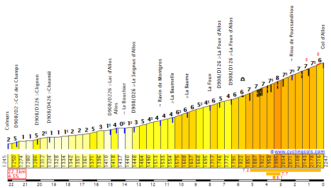
The same is true for the Col d'Allos although this is a much bigger climb. Longer, higher, steeper although never with really steep gradients. The last 5km are at 7% and this would be a good place to try a move if you don't want to wait until Pra Loup.
Interestingly, as I was searching for profiles for the climbs, I found out that this design is very similar to a stage of the 2015 TDF - which also started in Digne-les-Bains and finished in Pra Loup and contained Colle Saint Michel and Allos. Oh well :p

The climbs:
Col de Pierre Basse (2nd Category, 1068 m, 10.8 Km at 4.4%, Km 11.4)
Col de Corobin (3rd Category, 1205 m, 2.2 Km at 8.0%, Km 15.7)
Col du Défens (2nd Category, 1270 m, 7.2 Km at 4.6%, Km 52.6)
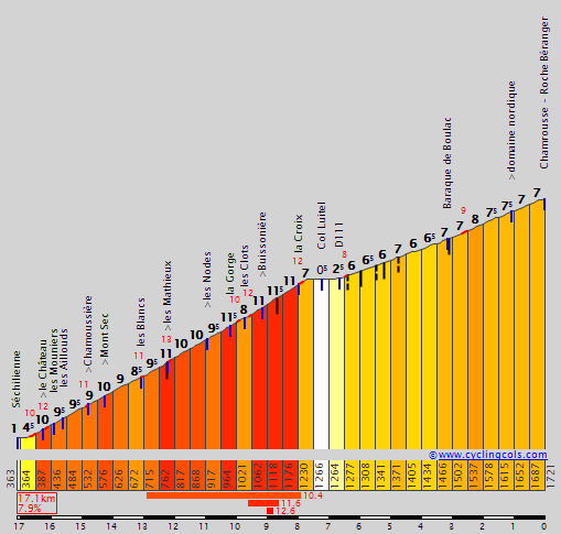
Colle Saint Michel (2nd Category, 1435 m, 18.8 Km at 4.2%, Km 111.4)
Col d'Allos (1st Category, 2238 m, 15.7 Km at 5.3%, Km 153.9)
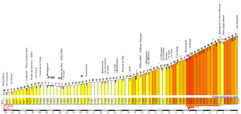
Pra Loup (2nd Category, 1615 m, 6.2 Km at 6.3%, Arrive)

CorobinW.gif

Col de Pierre Basse & Col de Corobin

DefendW.gif

Col du Défens

ColleSaintMichelS.gif

Colle Saint Michel

AllosS.gif

Col d'Allos

PraLoup.gif

Pra Loup

PROFILCOLSCOTES_1.jpg

The final two climbs

2XOTq8F.png

Hz5zr4E.png

Colle Saint Michel climb and descent

DHaZRqZ.png

Q0WhH1n.png

Col d'Allos climb and descent - scary drops in some parts of the downhill

zFNlh4r.png

Pra Loup ascent
 
Deutschland Rundfahrt, 3. Etappe: Leipzig - Bayreuth: 213km, flat

duOH94o.jpg


The 3rd stage of my Deutschland Rundfahrt starts in Leipzig, known for the massive battle fought here during the Napoleontic wars, and from a more peaceful point of view, as a hub for classical music. Johann Sebastian Bach, Richard Wagner, Felix Mendelssohn and Edvard Grieg all lived and worked here.

800px-Leipzig_Skyline.jpg


The stage starts out rather calm, with two minor climbs after 48km and 79km, but gradually the road becomes more and more rolling once the 100km mark is passed. Numerous small rises and a few categorised climbs will certainly sap the riders' legs, but probably won't cause any splits in the peloton. That can change with 30km to go, as the most difficult climb of the day kicks in. Although not a monster climb, the combination of distance already covered and the rough course, can shell some people from the back. The following long but gradual descent leads to two small climbs in a matter of merely 7km. None of them is a garanteed legbreaker, but they can provide a nice launching platform for the daring, as they are followed by 10 slightly descending kilometers to Bayreuth.

800px-Marktplatz_Bayreuth.JPG


Bayreuth is another city with a link to classical music, as attested by the annual Festspielen, a music festival at which operas by Wagner are performed.
 
Thanks. I'll have a look.
Edit:
I've had a look and Champs - Allos - Pra Loup would be around 5600m vertical gain and 202km, St Michel - Champs - Cayolle - Pra Loup 5800m and 212km. I try to avoid huge stages like that usually. Rightly or wrongly I have 5000m as my limit most of the time, of course it depends on the overall toughness of the race though. For the Giro I often make an exception. :)

a Champs - Cayolle - Pra Loup combo without St Michel is a possibility for me though
 
Yeah, I remember people had a problem with that stage in 2015 since it was really light compared to the brute in 1975. I read about that stage recently, it was a monster, you are coming from a different direction tho, that stage come from Nice and tackled Saint Martin and Couillole like this year's Paris-Nice, then Champs, Allos and finally Pro-Loup.
 
Oct 4, 2015
417
1
3,030
While making my Tour, I briefly considered including a Manosque-Pra Loup stage (after Ventoux or Paul Ricard)... using pretty much the same route LaFlorecita used.
Dodged a bullet there :lol: .
Nice medium mountain stages in Germany. I haven't really tried to draw many stages in Germany so far; I know there's some amazing hilly/medium mountain stages all over the place, and murderdeathkill walls in the German Alps, but haven't really tried to make something out of that. I should do that eventually.
(Another issue is that I simply can't find good cobbled roads reliably outside of the typical Paris-Roubaix stuff for some reason...)

Tour de France Stage 17: Albertville - Albertville, 29km (ITT)
seaXlJn.png

Fl9nv2e.png

Climbs: La Forclaz (cat. 2)

The third and decisive week will be short, with only five stages, one of which would be the typical Paris sprint stage. The first of the other four, a mid-length mixed ITT around Albertville, may end up being decisive, though. With almost 30km of stage, it's still a long enough TT for important gaps to appear.
The first third of the time trial is pan-flat and straight, along the western bank of the Arly river until the 7th km, where the route crosses over to the eastern side.
Then, right after the first time control at L'Île, TT specialists will run into a critical obstacle: the cat. 2 Col de la Forclaz. Not too long, but with a fairly steep 2km section near the end.
Forclaz2W.gif

After Forclaz the route intercalates flat sections and shallow descents along relatively straightforward roads (except for a couple hairpins right after La Forclaz), which should be favorable for specialists. Still, with the climb along the route, and the wear of 16 stages already on the legs, this stage is more of a test of strength among the remaining favorites.
 
Stage 18: Cuneo > Briançon - 166km - high mountains
https://www.la-flamme-rouge.eu/maps/viewtrack/hd/133642
LtBDgvm.png

ST8NYp7.png


Originally I wanted to do a stage finishing in Briançon with Col du Parpaillon - Col de Vars - Izoard but looking on Streetview and Google images I noticed Parpaillon at the top is untarmacked, now I don't mind some gravel roads but this looked really rough so I decided to leave it out. Of course, then this stage would basically be a copy of stage 18 in this year's Tour and I didn't want that either, so I decided to approach Izoard from a different direction, from Cuneo in Italy. The most logical route is via Colle dell'Agnello and I added in Colle di Sampeyre as well. I wasn't sure about this because the road condition of the descent is pretty bad, but let's just say it will be resurfaced ;)
With 3 HC climbs and 5000m vertical gain, this is queen stage of my TDF. All 3 climbs have steep gradients and with the Agnello summit at above 2700m, the altitude could play a role as well.
Colle di Sampeyre is around 18km long with an average gradient of around 7.5% - don't be fooled though, because this includes a 4km long (false) flat section. Then we have the brutal Agnello, extremely long (over 30km) and the final 8km are at an average gradient of around 10%. The final climb, Col d'Izoard, starts off quite easy and gets gradually steeper, with the last 7km constantly at 8-10% with the exception of a short downhill section with 2.5km to go. After a 20km downhill, the riders reach Briançon, where they will face a ramp again in the final km (poor guys!) This ramp is a staight road around 500m at 7-8%.

The climbs:
Colle di Sampeyre (Hors Catégorie, 2269 m, 18.0 Km at 7.3%, Km 59.4)
Colle dell'Agnello (Hors Catégorie, 2719 m, 31.4 Km at 5.6%, Km 106.4)
Col d'Izoard (Hors Catégorie, 2342 m, 14.0 Km at 7.1%, Km 145.6)

F6q3Uf2.png

The final 5km

SampeyreSE.gif

Colle di Sampeyre

AgnelS.gif

Colle dell'Agnello

IzoardS.gif

Col d'Izoard, the last 14km of this profile are in the race

JZClWFe.jpg

7tAwFKX.png

Colle di Sampeyre ascent

Mbh9bFr.png

6VSD8Uj.png

Colle di Sampeyre descent, bad road conditions in some sections

JUhlbzc.png

KTKbck5.png

Colle dell'Agnello climb

VIPGBOV.jpg

Col d'Izoard

XXeApkr.png

fhGtTd4.png

Izoard descent

ebBwJhY.jpg

4xAZ9YR.png

Finishing ramp


Stage 19: Grenoble > Grenoble - 44km - individual time trial
https://www.la-flamme-rouge.eu/maps/viewtrack/hd/133649
384sEqG.png

YAAQBvD.png

This is the 2nd ITT of the race and it's not definitely one for the specialists, but more for the stronger TTers among the GC contenders. It contains two short but quite steep climbs. The first one, to Quaix-en-Chartreuse, is around 4km long at 7.3%, with the steepest km being almost 10%. The second climb starts off steep, climbing to Clémencières, and then continues towards the summit of the Col de Vence with lower gradients. In total there is ~10km climbing, ~10km downhill which leaves around 24km of more or less flat roads, which is more than the total distance of the first flat ITT.

n00t6tk.png

The first climb

wUFfupD.png
civR5x5.png

The 2nd climb is the first profile + the last ~4km of the second profile

LL207dc.jpg

First climb

VJlHr02.jpg

l1HfG1v.jpg

First part of the 2nd climb is quite narrow

cP3sVuF.jpg

HKi8iuT.jpg

The descent of Col de Vence, not too technical
 
Re:

LaFlorecita said:
Stage 18: Cuneo > Briançon - 166km - high mountains
https://www.la-flamme-rouge.eu/maps/viewtrack/hd/133642
LtBDgvm.png

ST8NYp7.png


Originally I wanted to do a stage finishing in Briançon with Col du Parpaillon - Col de Vars - Izoard but looking on Streetview and Google images I noticed Parpaillon at the top is untarmacked, now I don't mind some gravel roads but this looked really rough so I decided to leave it out. Of course, then this stage would basically be a copy of stage 18 in this year's Tour and I didn't want that either, so I decided to approach Izoard from a different direction, from Cuneo in Italy. The most logical route is via Colle dell'Agnello and I added in Colle di Sampeyre as well. I wasn't sure about this because the road condition of the descent is pretty bad, but let's just say it will be resurfaced ;)
With 3 HC climbs and 5000m vertical gain, this is queen stage of my TDF. All 3 climbs have steep gradients and with the Agnello summit at above 2700m, the altitude could play a role as well.
Colle di Sampeyre is around 18km long with an average gradient of around 7.5% - don't be fooled though, because this includes a 4km long (false) flat section. Then we have the brutal Agnello, extremely long (over 30km) and the final 8km are at an average gradient of around 10%. The final climb, Col d'Izoard, starts off quite easy and gets gradually steeper, with the last 7km constantly at 8-10% with the exception of a short downhill section with 2.5km to go. After a 20km downhill, the riders reach Briançon, where they will face a ramp again in the final km (poor guys!) This ramp is a staight road around 500m at 7-8%.

The climbs:
Colle di Sampeyre (Hors Catégorie, 2269 m, 18.0 Km at 7.3%, Km 59.4)
Colle dell'Agnello (Hors Catégorie, 2719 m, 31.4 Km at 5.6%, Km 106.4)
Col d'Izoard (Hors Catégorie, 2342 m, 14.0 Km at 7.1%, Km 145.6)

F6q3Uf2.png

The final 5km

SampeyreSE.gif

Colle di Sampeyre

AgnelS.gif

Colle dell'Agnello

IzoardS.gif

Col d'Izoard, the last 14km of this profile are in the race

JZClWFe.jpg

7tAwFKX.png

Colle di Sampeyre ascent

Mbh9bFr.png

6VSD8Uj.png

Colle di Sampeyre descent, bad road conditions in some sections

JUhlbzc.png

KTKbck5.png

Colle dell'Agnello climb

VIPGBOV.jpg

Col d'Izoard

XXeApkr.png

fhGtTd4.png

Izoard descent

ebBwJhY.jpg

4xAZ9YR.png

Finishing ramp


Stage 19: Grenoble > Grenoble - 44km - individual time trial
https://www.la-flamme-rouge.eu/maps/viewtrack/hd/133649
384sEqG.png

YAAQBvD.png

This is the 2nd ITT of the race and it's not definitely one for the specialists, but more for the stronger TTers among the GC contenders. It contains two short but quite steep climbs. The first one, to Quaix-en-Chartreuse, is around 4km long at 7.3%, with the steepest km being almost 10%. The second climb starts off steep, climbing to Clémencières, and then continues towards the summit of the Col de Vence with lower gradients. In total there is ~10km climbing, ~10km downhill which leaves around 24km of more or less flat roads, which is more than the total distance of the first flat ITT.

n00t6tk.png

The first climb

wUFfupD.png
civR5x5.png

The 2nd climb is the first profile + the last ~4km of the second profile

LL207dc.jpg

First climb

VJlHr02.jpg

l1HfG1v.jpg

First part of the 2nd climb is quite narrow

cP3sVuF.jpg

HKi8iuT.jpg

The descent of Col de Vence, not too technical

Alternative road of the Sampeyre, I've never seen it in a profile like that. I'm guessing cramming in the Col d'Esischie or Fauniera before that would be too much, though then it might be better to take the Col de Vars instead of the Izoard and finish in Guillestre.

And I love that TT by the way. I think good, hard hilly TTs are hard to design, but this is absolute a good one.
 
Re: Re:

Red Rick said:
Alternative road of the Sampeyre, I've never seen it in a profile like that. I'm guessing cramming in the Col d'Esischie or Fauniera before that would be too much, though then it might be better to take the Col de Vars instead of the Izoard and finish in Guillestre.

And I love that TT by the way. I think good, hard hilly TTs are hard to design, but this is absolute a good one.
It's SP335, from the south you could also take SP104 but unfortunately the Google Earth car didn't go there, I like to check climbs & descents before I use them :p I once thought I'd found a neat little climb and it turned out to be a donkey trail. Lesson learned :lol:
SampeyreSW.gif


Adding Esischie or Fauniera would be something for Zomegnan. Vars after Agnello with a finish in Guillestre isn't possible I think as Guillestre is on the north side of Vars.
 
Im sure almost everyone designing stages would have went overboard, full ***, and included Esischie or Fauniera. Thats why I like this place so much. But its also good at times to keep it somewhat realistic. ;) It reminds me of the Galibier stage Andy won, but needless to say Sampeyre >>> Galibier S.
 
Re:

Valv.Piti said:
Im sure almost everyone designing stages would have went overboard, full ***, and included Esischie or Fauniera. Thats why I like this place so much. But its also good at times to keep it somewhat realistic. ;) It reminds me of the Galibier stage Andy won, but needless to say Sampeyre >>> Galibier S.
there"s certainly a truth in that i usually don"t really love races of attrition or having too a lot of climbs before action can really happen

I think many mountain stages usually have some sort of bottleneck in the parcours before which you"d never get any action in the first place

when thats the MTF you don"t need much before that anyway

The greatest thing about stages like Foix this year is that they don"t really have that sort of climb everyone is waitig for and they can just go
 
200+ km mountain stages with 5000+ m should be in every GT imo. As Riis says the one in '15 was too easy conpared to the one in '75 and it didn't bring big gaps for the first 4 GC riders of the stage (Quintana only finished 15 seconds ahead of Nibali) and I think a hardened version can bring better gaps.
The next stage though is just awesome. Sampeyre-Agnello-Izoard. :cool: Also using the unconventional side of Sampeyre is a nice change.
The total km of TTs looks a bit less for my liking though. It should have been around 100 km in my opinion since the second TT has some hills.
 
Re: Re:

Red Rick said:
Valv.Piti said:
Im sure almost everyone designing stages would have went overboard, full ***, and included Esischie or Fauniera. Thats why I like this place so much. But its also good at times to keep it somewhat realistic. ;) It reminds me of the Galibier stage Andy won, but needless to say Sampeyre >>> Galibier S.
there"s certainly a truth in that i usually don"t really love races of attrition or having too a lot of climbs before action can really happen

I think many mountain stages usually have some sort of bottleneck in the parcours before which you"d never get any action in the first place

when thats the MTF you don"t need much before that anyway

The greatest thing about stages like Foix this year is that they don"t really have that sort of climb everyone is waitig for and they can just go
I mostly agree but even if everyone will likely wait for the final climb I like to add some other climbs to at least offer an opportunity and weaken the legs.
But sometimes slightly easier stages are better than the extremely hard ones. It comes down to balance I guess, too many easy stages and the riders will be way too fresh, too many tough stages and riders will be too fried to try anything at all. I can definitely understand that opinions will differ about what exactly the right balance is.

Forever the Best, about the TT km - I usually look at it from the perspective of today's peloton. I imagine which riders would do well on which stages and what the gaps on GC would look like. That's why I try to avoid too many flat TT km in the TDF - because it would just make Froome even more dominant. In my TDFs I have had between 30 and 70km of TT. In the Giro, I don't mind as much and will often have 50km or more with an upper limit of 100km, I guess. But that would probably include a MTT.
For the Vuelta, around 30km rolling TT most of the time :p just depends on the sort of race you want to see.
Again, I can see why people would disagree. It's just my take on race design.