Race Design Thread

Page 85 - Get up to date with the latest news, scores & standings from the Cycling News Community.
After the natural and cultural beauty of Taiwan and Croatia, and the sheer madness of Eshnar's all mountains giro, I'll start something more down-to-earth.
I'll try to design a fantasy version for what is deemed by many as the worst protour race around: the eneco tour. Contrary to what the organisers of this race often do, I'll try to design a parcours that doesn't favour the pure TT'ers big time. My main goal is to design a race that covers almost every terrain that Belgium and the Netherlands have on offer. Since I think there are enough opportunities to gain time on the TT-specialists, there will be no time bonuses at all.
There will be two side classifications: a points classification and a KOH (king of the hill classification).
The first 15 of each stage gain points for the points classification: 25-20-16-14-12-10-9-8-7-6-5-4-3-2-1 and during stages in line there's one intermediate sprint with 10-7-5-3-1 points on offer.
The hill classification takes climbs of 1st, 2nd and 3rd category into account, with the following point distribution:
1st category: 10-7-5-3-1
2nd: 5-3-2-1
3rd: 3-2-1

OK, time to start.

Stage 1: Leeuwarden - Groningen, 161km
We'll start in the north of the Netherlands, in the capital of the province of Friesland: Leeuwarden. The peloton will head southwest to Workum, one of the famous Frisian "eleven cities". After some 40km, just before reaching the Ijsselmeer, this stage turns southeast and after 80km northeast, loosely following the Frisian border and contesting the intermediate sprint in Oosterwolde after 121km. After 135km the race enters the province of Groningen, where they will finish in it's capital: surprisingly named Groningen.

Groningen:
800px-Groningen_-_Hoge_der_A_-_vanaf_de_A-brug_-_Bert_Kaufmann.jpg


stage map:
enecoet1.jpg


Stage 2: Kampen - Zwolle, 19.5km TT
Instead of waiting until the final days, I decided to place the still important TT at the beginning of the race. Hereby I hope to create more attractive race dynamics where the leader will be attacked during the remaining stages, rather than waiting the whole tour for the final TT, with some feeble attacks during stages that aren't half as difficult as they could have been made. The distance may just be a bit to long for this race, but I think the remaining stages can make up for it. This TT starts in the town center of the former Hanseatic city of Kampen and follows the left bank of the Ijssel river to finish in the city of Zwolle. The stage heads in a generally southeast direction, inland from the Ijsselmeer. So, there's a huge possibility that there will be a tailwind, resulting in an insane average speed. There probably is some road furniture to tone that speed down, however.

Zwolle:
640px-Zicht_op_Zwolle_Centrum.jpg


stage map:
enecoet2.jpg


race profiles for both stages: _____________________________ so there are no mountain points on offer yet.
 
The Col du Lein requires no beefing up! The Col du Lein stands alone!

Stage 17: Lahr - Bergstation Belchen, 205km

2hwh45l.png


eip94y.png


Climbs:
Streitberg (cat.3) 5,8km @ 4,3%
Höhenhäuser (cat.2) 5,5km @ 6,2%
Kandel (HC) 11,8km @ 8,2%
Notschrei (cat.1) 13,5km @ 5,4%
Rollspitz (cat.1) 9,2km @ 6,9%
Schauinsland (cat.1) 7,3km @ 8,2%
Notschrei (cat.1) 13,5km @ 5,4%
Bergstation Belchen (cat.1) 11,1km @ 7,3%

Sectors:
1) Alt-Kirchzarten
2) Wallstraße/Adelhauerstraße
3) Freiburg Universität/Freiburg Rathaus
4) Schwabentor

The mountains really hit us with a vengeance today as the riders are in for a really hard stage in the Schwarzwald, with more cat.1 climbs than in the previous 16 stages put together, and also our first hors catégorie climb. A very short - circa 15km - transfer from yesterday's finish has us once more on the western periphery of the Schwarzwald mountains, and again we start the stage by easing the riders in with a couple of smaller, more easily rideable climbs in the foothills. However, 45km into the stage, the alarm bells will inevitably start ringing for the less climbing-adept in the bunch, as we start the serious stuff with the hardest pass in the region, the 1241m high Kandel. As the profile shows, it's mostly consistent though there are some steeper sections in its 12km of climbing at a far-from-inconsiderable 8%. Then it's a winding descent via Sankt-Peter into the first cobbled sector in a while, the pedestrianised centre of Kirchzarten. After that we enter into a very long loop that takes up most of the rest of the stage, beginning with the gradually steepening ascent, through the wooded turnsto the Nordic Center Notschrei. Though the overall average of 5,4% is unimpressive, the last 6km are at more than 8% so the riders will certainly feel this and be glad of the respite as they descend into the pretty town of Schönau. Here, they turn right onto a road called Belchenstraße, which we will follow for much of the way up to the summit before heading right to crest the Rollspitz (the profile here shows the climb to Wiedener Eck, so includes 3km of descent after the actual summit at Rollspitz). This climb is quite inconsistent so could hurt some legs, before the riders descend straight into the next punishing gradients, this time ascending the shortest but most brutal side of Schauinsland, with the first 3km reaching up to 20% as we snake up to the summit. It does ease up a bit but still merits category 1 status, before a long descent into another city with a great deal of cycling history it would rather forget - Freiburg. The first half of the descent is very, very technical, but the second half is wide open and fast.

Freiburg itself hosts three cobbled sectors to break up the stage, the first on Wallstraße and Adelhauser Straße, the second between the notorious Universität (Blutenbank) and the Rathaus, and the last heading to - and through - Schwabentor. This is part of a section of about 15km which is only false flat, downhill or uphill, and constitutes the flattest part of the whole stage. After this, the riders tackle the climb to Notschrei once more, which is where I would expect GC action to start to begin (I know, tautology). This time the summit is 24km from the finish, and half of that is descent. Action time, with that final 6km at 8%. If not, there's always the mountaintop finish to come - the first real, major MTF of the race, you could argue (depending on your opinion of whether Großer Feldberg, if you split Mammolshain out, counts as a major MTF, or whether the kilometre of flat into Grünhain means we can't consider the Teufelstein stage an MTF). The climb to the mountain station at Belchen, one of the best known mountains in the area, is the same for the first 2/3 as the Rollspitz earlier, but where that splits off to the right, the Bergstation climb continues to the left and climbs somewhat further besides. The steepest part of the Rollspitz climb - hitting 22% - remains intact, but the longer finish - mostly on exposed roads averaging around 6% but with the final 300m getting somewhat steepr - means more time for riders to do something with the separation that these steeper ramps inevitably create. And besides, no rest days after Großer Feldberg (ironically the highest point in the Schwarzwald is called Feldberg, and it dwarfs the Großer Feldberg), Saarbrücken and yesterday's multi-mountain stage, means some tired legs, not least with Kandel, Notschrei, Rollspitz and Schauinsland in them.

Lahr:
9461480.jpg


Bergstation Belchen:
27533784.jpg
 
Eneco tour, stage 3: Hoogeveen - Nijmegen, 183km

The third stage is the first stage with more than a speedbump for elevation gain, although it are still minor hills the riders have to deal with.
The stage starts in Hoogeveen, in the province of Drenthe but quickly and heads south, more or less parallel with the German border. The only thing we can hope for is a breakaway to spice up the first three quarter of this stage. The intermediate sprint is placed after 128km in the city of Doesburg, just before the peloton crosses the Ijssel river on their way to Arnhem. Just before Arnhem the race fatures two climbs also known from Veenendaal-Veenendaal (or the Dutch food valley classic). Although no trained cyclist will break any sweat to climb them, they give the opportunity to stage an attack, or at least to try to grab the points for the hill classification.
In Arnhem this stage crosses the Lower Rhine -no bridge too far- and heads for the city of Nijmegen, whose outskirts are reached with 22km to go after crossing the Waal river. At this point the teams with the contenders for GC and those with a sprinter can set up a train to take control of a hectic final. In the last 8km there are 2 more hills to climb, the last one topping out with just 2km to go. This climb, just 400m @ 10% can be a springboard for any puncheur still around.

Racemap and profile:
enecoet3.jpg


Nijmegen:
800px-Sintstevenvanafsnelbinder.jpg


climbs:
km 140: posbank, 3rd category
km 145: Emmapiramide, 3rd category
km 177: Nieuwe Holleweg, 2nd category
km 181: Beekmansdalseweg, 3rd category
 
Stage 18: Singen - Oberstdorf, 187km

vdpi5i.png


xc3pef.png


Climbs:
Heiligenberg (cat.3) 5,8km @ 4,4%
Ebensbacher Berg (cat.4) 1,4km @ 5,8%
Gunzesried (cat.3) 2,2km @ 7,4%
Schöllang (cat.4) 2,5km @ 4,7%

Sectors:
1) Wangem im Allgäu Stadtmitte
2) Immenstadt-Zentrum

The Thursday of the final week sees a comparatively light stage, with just a couple of each obstacle - 2x category 3 climbs, 2x category 4 climbs and 2x cobbled sectors, on what is really a pure transitional stage taking us from the edges of the scenic Bodensee, which forms a long section of border between Germany, Switzerland and, at its eastern edge, Austria, through picturesque towns and cities like Überlingen into Bavaria, where the race's ultimate three stages will take place. The two cobbled sectors, the final points available in the Kopfsteinpflasterkönig classification (which realistically will have been sorted in the first half of the race, I'd expect, unless it's a two horse race where you would see a couple of rouleurs trying to get in the break here I guess), are unchallenging town centre, well kept cobbles in Wangen im Allgäu and Immenstadt as we head into the foothills of the Allgäuer Alps.

The climbs today are hardly destructive, though the toughest of these, to the village of Gunzesried overlooking Sonthofen, peaks with 26km remaining and over its 2,2km length it hits a maximum of 19%. There is another climb after this, but this is all at a fairly consistent gradient of just under 5% so not likely to spell too much danger. If this stage goes to the break, I can see the decisive moves being made here. But realistically, this is the last chance for the sprinters, so if any have bothered staying in the race after the Nürburgring pursuit race, then their teams will be putting the hammer down to keep this one for them. The stage finishes in another traditional wintersports town in the south of Germany, with the stage finish beneath the fabled Schanzen of the Erdinger Arena, one of the Four Hills from the legendary ski jumping tournament.

This area serves as a good starting point for some of the most brutal climbing in Germany, with the Nebelhorn and Schlappold-Alpe (itself just a step on the way to Bergstation Fellhorn, but including all the toughest parts) both starting nearby. In fact, my earliest draft of the route had a Schlappold-Alpe MTT at this point and the transitional stage the next day, however it simply isn't feasible and so I've had to rejig things. I think Bavarianrider had the exact same issue with his Nebelhorn TT, actually, only that's even less realistically plausible, so these brutes remain for cyclotourists only for the time being, though I guess a small amateur race that doesn't need the race caravan of a larger event may be able to fit there.

Either way, this just means that today's a bit of a respite so the legs can get a bit of feeling back after the Nürburg TT/pursuit, Großer Feldberg, the leg breaking Saarbrücken stage and the two Schwarzwald mountain stages, ahead of the big finale.

Singen:
constellium-singen-plant-aerial-view.png


Oberstdorf:
609UrlaubOberstdorf005.JPG
 
Stage 15: Bovec - Pian Delle Streghe 187 km
We're back for good to Italy, where the riders will discover a close neighbor of Crostis and Zoncolan: Pian Delle Streghe.
stage15.png


Vrsic: 12.6 km at 7.8%
Nassfeldpass: 11.2 km at 8.2%
Passo Cason di Lanza: 15.6 km at 6.4%
Passo Duron: 4 km at 10%
Pian Delle Streghe: 10.5 km at 8.8%
 
Stage 16: Comeglians - Zoldo Alto 191 km
First day into the Dolomites, with a easy one. The only difficulty of the day is the climb up to the Rifugio Talamini, short and very steep.
stage16.png


Sella Di Razzo: 24 km at 5%
Forcella Cibiana: 10.3 km at 7%
Rifugio Talamini: 6.3 km at 12%

9588.gif
 
Stage 18: Trento - Moena 175 km
The most classic of the Dolomitic stages, but the riders will have to conserve themselves, because the next stage will feature one of the two ungodly monsters of this edition! :D
stage18.png


Vetriolo Terme: 10 km at 8.6%
Passo Brocon: 28.6 km at 4.7%
Passo Rolle: 22.2 km at 5.5%
Passo Valles: 7 km at 6.9%
Passo S.Pellegrino: 6 km at 8.6%
 
Stage 19: Badia - Edelweiss 179 km
And here it is! Terento, Furcia, Erbe and finally the monster starting from Bolzano!
stage19.png


Terento: 8.6 km at 5.8%
Passo Furcia: 9.1 km at 8.1%
Passo Delle Erbe: 15.2 km at 6.1%
Edelweiss: 8.6 km at 13.2%

san_genesio.gif
 
Dec 16, 2011
345
0
0
Tour of Taiwan

Wow, i"m quite surprised that Eshnar has managed to find all the climbs for a third mountain Giro. The last week looks really epic. Also like Rghysens Eneco Tour. As a fellow countryman I am looking forward to see a spiced up version of this race.

But now, back to Taiwan:

Stage 7: Puli - Zhunan (154 KM)

After the crazy hard 6th stage, today will provide a bit of a rest before the final weekend. I don't know anything about both Puli and Zhunan. This is just a transition stage without anything mentionable.

Profile:

stage7.png
 
Dec 16, 2011
345
0
0
Tour of Taiwan

Stage 8: Miaoli - Smangus (144 KM)

Today's stage is propably my favourite stage in terms of design. There are no less than 6 categoried climbs, and there is barely any moment for rest. After 6 hard stages there will be already huge differences in the General Classification, but courageous riders can gain a lot of time back here.

Directly from the start in Miaoli city the climb of the Xian Shan needs to be tackled. This 7 kilometer at 8% climb is a perfect opportunity to form a strong breakaway group. From there on, the next 50 kilometres will be relatively easy. But in the second half of the race, no meter will be flat.

After 70 kilometres the Shandong Feng (9 KM at 7%) apears. And the suffering will continue with the Yimei Shan (5 KM at 8%), and the hardest climb of the day, the Xiayulao (13 KM at 8%). From there are only 35 kilometres left to the finish, but there are still 3 climbs to go. First the short but steep climbs to Taigung (5 KM at 10,5%) and Juansi (4 KM at 10,5%), and eventually the final climb to the communal village of Smangus (6 KM at 6,5%). This village used to be well known because of the ancient cypres trees. From now on it will be known as the finishing place of this cruel stage!

Profile

stage8.png


Smangus

8028753438_6e2f52abda.jpg
 
That second half of the stage looks like relentless punishment.

Stage 19: Garmisch-Partenkirchen - Axamer Lizum (AUT), 160km

34owpya.png


5ajjba.png


Climbs:
Berwang (cat.3) 4,3km @ 6,0%
Namlossattel (cat.4) 2,8km @ 5,1%
Hahntennjoch (HC) 14,8km @ 6,4%
Silzer Sattel (HC) 9,7km @ 10,5%
Kühtai Sattel (cat.2) 7,8km @ 6,1%
Axamer Lizum (HC) 13,5km @ 7,2%

I am cheating a little here with a stage which takes place mostly in Austria, but then all the GTs use neighbouring countries and besides the real life Deutschlandtour used to hold queen stages in Austria not infrequently (and often frustratingly given the tendency not to use the terrain that the home nation gave them often!), so I don't feel too bad about using it as a replacement for the abandoned Fellhorn ITT. However with three HC-categorised climbs crammed into its relatively short distance, this is a really stern test of the riders, so they'll be glad of the relative peace I gave them yesterday.

The stage starts in the popular Alpine city of Garmisch-Partenkirchen, perhaps inevitable when looking for large settlements in the German Alps. Formed out of the forced union of the two Alpine towns of Garmisch and Partenkirchen by the NSDAP in order to make Germany more likely to win the bid to host the Winter Olympics (a bit which succeeded), it has grown into perhaps Germany's best-known winter resort, though more of the development has been in the more modern Garmisch end of town, while Partenkirchen remains more traditional. It is almost entirely now known for wintersports, being the other German contribution to the Four Hills (for the uninitiated, the other two are the Austrian hills of Innsbruck and Bischofshofen) as well as the host to one of the blue riband rounds of the FIS Alpine Skiing world cup, and the hometown of many of Germany's best alpine skiers, with both the Neureuther and Riesch families coming from here. It's also very close to the Kaltenbrunn/Mittenwald biathlon facilities, and as a result has given Germany many of its top biathletes in recent years, however curiously all of these have been women (Martina Glagow was born in Garmisch-Partenkirchen though brought up in Mittenwald, Magdalena Neuner's from Wallgau, a village/small town in the GaPa municipality, Miriam Gössner's from Garmisch and Laura Dahlmeier's from Partenkirchen). But amid the wintry history, it's time to add a bit of summer sport, and take advantage of those lovely mountains in this part of Germany and Austria (Germany's highest peak, the Zugspitze, overlooks the town), on bikes.

Crossing the border into Austria, the riders head straight for the Namlostal, a scenic valley with a blend of twists and turns and hairpins split over a couple of hills and rolling sections. Nothing too jarring for the riders just yet, but some warming up before the real action begins. After 60km of up and down, it most certainly does.

The Hahntennjoch is a surprisingly little-heralded major Austrian climb, with the final 5km coming at an average of 10% including some brutal sections, though the period of false flat on this, which is actually the easier side of the climb, lowers its average. Nevertheless, there's plenty of steep twisting sections and attractive spots and impressive vistas on its fifteen kilometre slog, which is then followed by a mostly very straight and fast descent into the sometime winter wonderland of Imst, with only a couple of switchbacks providing stern technical tests. Then we have 15km of rolling valley roads before things turn ugly fast.
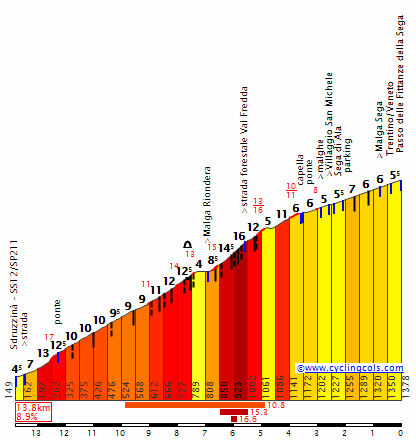
The Silzer Sattel is an absolute murderer of a climb, relentlessly punishing the riders with poor surfaces, continual switchbacks and slaughterhouse gradients for nearly 10km. Starting with 55km remaining, I can't see there being much of a front group remaining by the end of its tortuous slopes, because most of the riders will be begging for mercy and will gladly take an autobus day over this destructive ascent. The summit gives out maximum mountain points for a reason, but it's not the true summit per se, for this is part of the ascent - by the hardest possible route - to the scenic Kühtai Sattel, last seen in a pro race in the 2005 Deutschlandtour, when it was climbed from the side we are descending today as the lead-in climb to the Rettenbachferner. There's still a whole category 2 climb left to tackle, as after a short descent into Ochsengarten there's still the last 8 kilometres of this side of the climb, which as you can see is pretty tame compared to the Silzer Sattel, but still has some tough moments and when you consider the bunch should be pretty small and the riders have hardly had any respite after the previous climb's pummeling, should continue to punish the riders' legs. Quäl dich! makes the combined ascents 19,2km at 7,7%, an impressive gradient when you consider there's 2km of descent in that!

At this point there's 35km to go, but this now leads into a very long and mostly very straight and fast descent, which has a couple of hairy moments of steep gradient but will mostly be no problems. The high speed could make things quite frenetic, which will be a problem as riders will want to make sure that they have enough gas left in the tank not to lose large amounts of time on the final climb of the day, the last mountaintop finish of the race, 13,5km of pulsing, inconsistent climbing up to Axamer Lizum, a specialist Alpine skiing venue constructed and developed for Innsbruck's hosting of the Winter Olympics in 1964 (thus bringing us full circle from the stage start in Garmisch). It gets quite nasty early, and people needing the most time will need to go on these first ramps. Which makes it quite nice that the first 2,5km include ramps of up to 14 and 16%, excellent platforms for attacks from those who still have time to make up from the cobbles and the time trials in weeks 1 and 2. Then some fairly 'normal' climbing leads to a flattening out after 5km, before the road turns skyward in earnest; the next 500m average over 10% and max out over 17%. The next 2km are really tough, before another more normal sector. The toughest section comes with 5km to go, with the gradients going up to an average of 12% for the next 800m, then it's averaging 9% constantly until the red kite. After this things flatten out almost completely, leaving us a faster final kilometre where any riders still together can look to gain time back on those ahead, before the final 200m being at a brutal 15% finally breaks them apart.

This one's going to be a big thing for the GC, and after several consecutive days in the saddle, it's really going to hurt.

Garmisch-Partenkirchen:
garmisch-partenkirchen-20%25255B2%25255D.jpg


Axamer Lizum:
lhbilder1008_0025.JPG
 
Eneco Tour, stage 4: Eindhoven - Bergen-op-Zoom, 192km

Yesterdays stage gave us a first taste of the hills, today the peloton has to tackle some cobblestone sectors (only one actually, but raced twice).
But let's take a closer look at the stage as a whole.
It starts near the PSV football stadion in the city of Eindhoven and heads west, but looping north of bigger cities like Tilburg or Breda (to avoid traffic problems). The race does pass the center of smaller villages like Zevenbergen or Steenbergen, however, on its way to the province of Zeeland which they will enter by crossing the Rhine-Scheldt canal after 120km. At this point, the peloton enters a large local lap where they'll contest the stage victory on some coastal roads, often exposed to fierce crosswinds. If they blow today, expect an almost immediate forming of several echelons, even more so because there's a stretch of 12km that passes on the oesterdam, a dam on the Eastern Scheldt river, which is basically a big cove of the north sea. After the Oesterdam, the race makes a 90° turn left, heading to the 2km long cobbled Hogerwaardweg, that leads to the village of Hoogerheide, well-known for its annual cyclocross event. But instead of going to the centre of Hoogerheide, the peloton once agaion has to turn left, towards Bergen-op-Zoom, where they'll pass the finish line for a first time after 151km. This will be the place for the intermediate sprint. After this interlude the stage heads northwest again, for a second crossing of the Rhine-Scheldt canal, followed by a second passage of the Oesterdam, Hogerwaardweg and finally the finishline after 192km.

Profile: ____________________________

Stagemap:
enecoet4.jpg


Oesterdam:
oesterdam.jpg


Hogerwaardweg:
hogerwaardpolder.jpg


Bergen-op-Zoom
640px-Bergen_op_zoom_006.jpg
 
STAGE 20: Selva - Proves 183 km
Hard stage with a tricky finale.
stage20.png


Passo Nigra: 25.4 km at 5.4%
Prati Di Kohl: 10.9 km at 10.1%
Passo della Mendola: 14.6 km at 6.5%
Forcella Di Brez: 6.4 km at 9.1%
Proves: 4.8 km at 8.3%

PratiDiKohlN.gif

BrezE.gif
 
STAGE 21: Lana - Peri 229 km
The queen stage.
The other one of the super hard monsters of this edition starts from Torbole, on the Garda Lake, at 70m above sea level. The first 15.4 km of this road are named Prati Di Nago, 1520m above sea level (9.4% average). After that, the roads switch to sterrato and keeps on going up to the top of Monte Altissimo, at around 2040m, in just 3.8 km (13.7% average). The overall result is quite impressive: 19.2 km at 10.3%! After this giant, an enormous descent will bring the survivors at the foot of the Passo Fittanze Della Sega (see Trentino 2013); unlike Trentino the riders will tackle the Valico Cornetto, an additional steep ramp starting in Sega Di Ala. Overall the climb will be 13.5 km at 9.4%. After that, the riders will just have to stay up (and not faint) during the descent towards Peri.
stage21l.png


Forcella di Cloz: 24.5 km at 5.6%
Campo Carlo Magno: 14.9 km at 6.2%
Monte Altissimo: 19.2 km at 10.3%
Valico Cornetto: 13.5 km at 9.4%

FittanzeDellaSegaN.gif

10930.gif
 
Dec 16, 2011
345
0
0
Tour of Taiwan

Pff, Lana - Peri seems like the hardest stage posted ever posted. Already looking at the profile makes me tired.:eek:

Stage 9 : Taipei - Taipei (135 KM)

Off course, the Tour of Taiwan ends in it's capital Taipei. Today's stage brings new and old Taipei together. The start will be given in front of the hypermodern Taipei 101 scyscraper, and the finish will be in front of the impressive National Palace Museum. However, today's stage will be everything but a ceremonial ride! The first 10 Kilometers are flat, but that's it. From there on 8 climbs will await the peloton. The summit of the last climb is only 8 kilometres before the finish line. So, a lot of attacks may be expected!

Profile

stage9y.png


Climbs

KM 16: Bitan Shan (4,4 KM, 8,4%)
KM 27: Nanbanglio (6,5 KM, 4,6%)
KM 40: Cukenglun (5 KM, 7%)
KM 61: Zhuziyi Shan (5,5 KM, 7,5%)
KM 79: Pailiao Shan (4,2 KM, 6,7%)
KM 92: Kangaoken (4,3 KM, 9,5%)
KM 113: Zhongxiao (8,9 KM, 6,3%)
KM 128: Chishangtian Shan (3,8 KM, 8,5%)

Taipei 101

taipei-101-exterior-01.jpg
 

TRENDING THREADS