• The Cycling News forum is looking to add some volunteer moderators with Red Rick's recent retirement. If you're interested in helping keep our discussions on track, send a direct message to @SHaines here on the forum, or use the Contact Us form to message the Community Team.

    In the meanwhile, please use the Report option if you see a post that doesn't fit within the forum rules.

    Thanks!

Race Design Thread

Page 103 - Get up to date with the latest news, scores & standings from the Cycling News Community.
Northern Thailand Tour - 7

Stage 7: Lamphun - Doi Inthanon; 168 km

530peh.png


2mzbgbk.png


Here it is, the toughest climb in Thailand and also one of the world's most difficult ascents suitable for road races. After relatively flat stage with some punchy hills in the second half, route of this stage leads riders to the highest point in Thailand - Doi Inthanon. This beast starts mildly, but soon the first hard part comes with still 20 kms to go. It is 5.6 km long with average gradient of 11.6%. Middle section consists of two "steps" and is easier with longer more or less flat parts. However with 8 kms to the line, riders enter the second very steep part (6.2 km long with average 12.3%), which will definitely sort out the best from the rest. As you can see, the ITT on the previous day may have created some gaps, but on this kind of climb one can lose minutes quite easily.

KOM:
Mae Chaem (cat. 2) - 6.3 km; 7.6%
Doi Inthanon (cat. HC) - 22.2 km; 8.6%
jqqkpi.png


Photos:
Ob Luang national park - 1, 2
Doi Inthanon national park - 1, 2, 3, 4, 5, 6, 7, 8
Doi Inthanon road - 1, 2, 3, 4
 
These climbs in Thailand - the land of which there can be no doubt Zomegnan approves - make the Giro look rather, well, pedestrian!

Stage 19: Aosta - Pila-Ciel-Bleu, 181km

28ajmko.png


33wwci0.png


Climbs:
Col de Saint Barthélemy (cat.1) 15,8km @ 6,8%
Colle San Carlo (cat.1) 10,5km @ 10,0%
Col de Saint Nicolas (cat.3) 5,6km @ 8,5%
Verrogne 98 (cat.2) 9,5km @ 7,7%
Pila (cat.1) 17,5km @ 7,1%

As I mentioned on the last stage, I love the Valle d'Aosta. There are a lot of great climbs in a very small area, many of which are comparatively unknown to the sport. Naturally the region's home tour uses a lot of them, but as an U23 race it doesn't have the widest circulation so TV audiences never get to see a lot of them, except for the occasional Giro visit. The Tour could visit occasionally I guess, but tends to just serve up something like 2009's bland fare with Grand-St-Bernard and Petit-St-Bernard, missing out on a lot of potential greatness. However, the nature of the region as one valley with a number of smaller valleys within it does mean that there are only a few real passes that can be used, and I have tried my best to incorporate these into the stages; the beautiful and steep Champremier is missing, however, as is the Col de Joux (however, as I used its prettier, more dramatic, much steeper and tougher sister, the Col Tze Core, I don't think this is a problem. I love Tze Core). The toughest of them all, however, the Colle San Carlo, is present and correct. The choice then came down to finishes. While a smaller race could make use of several of the great climbs in the region - Valsavarenche-Pont (over 20km at just under 6%), the glorious scenery and multi-stepped climb of Lago di Place Moulin (20km at just over 5%), and the brutal slopes of Estoul (22km at nearly 7% beginning at the same point as Joux & Tze Core and with the last 8km at 8%) are all notable - a final MTF at the Giro is perhaps more in need of one of the bigger ski resorts in the region.

That I called for an MTF immediately ruled out La Thuile, and while a stage to Courmayeur with Colle San Carlo as the last major climb, then the smaller puncheur-type climb into Courmayeur to finish would be a great design, the Giro kind of needs a final mountaintop duel. This leaves three real options. Breuil-Cervinia is the most common in the Giro, with three appearances (1960, 1997 and 2012), but its slopes are mostly rather gradual, and as I already used Tze Core and Saint Pantaléon, the two toughest prospective introductory climbs, yesterday, it's out. That leaves two. Cogne is perhaps the most picturesque of the three, and the least used (only once, in 1985, has it appeared in Il Giro), however it isn't really steep enough. So Pila, which was featured in 1987 and 1992, it is!

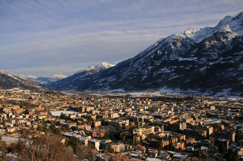
The stage starts in the capital of the Valle d'Aosta, Aosta itself, with its Roman theatre and historic centre. It only finishes about 20km away from there, but it loops around a fair bit. First, the riders head east, towards yesterday's stage town of Châtillon, but soon turn north, in Nus, towards the first big summit of the day, the Col de Saint-Barthélemy. That is just before the 16km mark on that profile (where it says Lignan, bivio per Porliod). Not fun. The descent takes us back to the outskirts of Aosta where we head up through the valley (including the climb of the Col d'Introd, which earlier in the race would probably have been categorised) via Arvier to Morgex, which sits both at the base of Petit-Saint-Bernard and the much, much harder climb the riders are now subjected to, the 10% average Colle San Carlo. This is only halfway through the stage, however, so it would be pure desperation for GC contenders to go here. That said, this thing if raced at any kind of pace will reduce the field to only the best climbers; the péloton will be down to its skeletal remains by this point. It was of course featured in the 2006 Giro, in a stage profile that, if 7km shorter, would have come straight out of Javier Guillén's fantasies. Zomegnan was responsible for that. Zomegnan! Can you believe that, with climbs like Verrogne, Saint-Barthélemy, Saint-Pantaléon, Champremier (averaging over 9%!), Tze Core, Joux and La Cerise available to him? A Unipublic stage? Its punishing lacets are here to hurt, and then the riders get to descend via La Thuile and Pré-Saint-Didier back to Morgex, where they head on downhill false flat retracing their steps from earlier, before a double-headed climb. Saint-Nicolas and Verrogne are not HC climbs in and of themselves, however they back into each other very nicely offering very little respite to the riders, and include some tough gradients. With the small village of Verrogne coming just 34km from the finish, things get frenetic. A long and winding descent takes us back into Aosta for the final time before we start the final, deciding ascent up to the legendary ski resort at Pila. This has some seriously steep stuff in the early going (a kilometre averaging over 11% just before the halfway mark), and apart from a couple of lighter kilometres in the middle it never lets up; there are many more options I could have taken and many other things I could have done with the Valle d'Aosta (and I will reveal some of these another time) - that I couldn't really find a way to include Champremier without complicating stage routes more than they already are was a frustration - but I think this is a more than serviceable final mountain stage to make the riders suffer and give us one final heroic mountain duel before the end of the race.

Aosta:
aosta-panorama.jpg


Pila:
dxe87r.png
 
Stage 20: Milano - Milano, 30,0km (ITT)

1195kit.png


acvprt.png


Not a great deal to say about this - it's an absolute 100% carbon copy of the 2012 closing TT. 30km almost down to the exact metre, and the final chance for GC time to be won and lost. I think 30km is the right length for a final day TT (if you have a ceremonial final day the TT would obviously be on the penultimate day, and in that case it can be longer. I'll explain). The winner of a GT should have a bit of time to savour their victory; however if the race is down to small time increments on the final day, then we could be in for an exciting show; the time increments need to be small though. As there is no ceremonial stage, the winner will likely know that they have won before the race is over and therefore be able to celebrate a bit on the bike, even showboat home à la Contador 2011. If you have another 55km TT here, a rider needs a pretty big margin in order to feel safe here; whereas if a rider has a celebratory parade day like in the Tour or Vuelta, it doesn't matter if they've had to work really hard the day before - it was the day before.

As the other TT was a 50km+ killer with a long flat stretch then a cat.2 climb, this one is pan flat, for the specialists that bothered to drag themselves over Monte Prata, Il Mangàrt, Pura, Giau, Fedaia, Siusi, Rodengo, Monte Giovo, Meran 2000, Sestrière, Tze Core, Saint-Pantaléon, Sant-Barthélemy, San Carlo and Pila.
 
Dec 16, 2011
345
0
0
Visit site
Tour de france without Alps and Pyrenees

Great stuff Libertine and Togo. Doi Suthep is propably the most beautiful temple I've ever seen. Chiang Mai is awesome anyway! I've been to Doi Ithanon as well, and it is a really scenic area. In between the two pagoda's is a really nice garden. I cannot remember the climb towards the top as being steep, but maybe our tuk-tuk took another approach. I also have the feeling that Tracks4bikers is less precise in Asia, and therefore makes climbs more irregular. Still, I'm really enjoying seeing all these great places included in such a nice race.

Let's continue with my Tour the France without Alps and Pyrenees. I hope you can still remember it, because I think in between two or three other versions of the Tour have been posted. As a reminder, my Tour started in Brest with a prologue. The first week featured some spinting and punchy stages, and brougth the riders into the Vosges. The weekend stages finished respectively at the Grand Ballon and Gerardmer (la Mausalaine). After this, a rest day was used for a transfer to the middle of France, where the race will continue.

Stage 9: Chatellerault - Futuruscope (31 KM ITT)

It's time to shine for the time triallists. I like it when Grand Tours include both a flat and a hilly time trial, but I don't want to discourage the pure climbers to much. So as a compromise I will include two time trials, but won't make them to long. Hereby I loosely follow the pattern of the 2013 Tour, where this approach worked out pretty well.

xg8p.jpg
 
Giro d'Italia

Stage 19: Castelnuovo Berardenga (Pianella) - Castellina in Chianti, ITT 22 km

or2lno8mhgk7.jpg


e4udjea7kf6j.jpg


The third last stage is a time trial in the Chianti mountains. It's 22 km long, of which 17,6 km are on strade bianche. Pianella is a tiny frazione of Castelnuovo Berardenga, just east of Siena. The stage starts directly on sterrato and with a drag up the hill you can see in the background. The road at first runs quite straightforward through the wide open Tuscan countryside, before a technical part with lots of bends in the woods follows. The descent from Vagliagli is on tarmac first, but then changes to sterrato in a right hand corner.

After the descent the last and with 9 km the longest sector of sterrato begins. It includes this nasty climb, which is 1,5 km long and has a section of 500 m at 13%. After a short flat bit, the next steep climb follows (300 m at 13% followed by 400 m at 6%). After that, the terrain is rolling, the last km is on tarmac. I'm not sure if time trial machines make sense here.

sterrato sectors:
km 0 - 2,0
km 2,3 - 3,3
km 3,9 - 5,3
km 6,3 - 9,8
km 11,5 - 12,2
km 12,4 - 21,4

Colline del Chianti:
chianti.jpg


Castellina in Chianti:
Castellina-01-1996.jpg
 
Giro d'Italia

Stage 20: Siena - Orvieto, 211 km

Toscana part:
igp8yln9ypt7.jpg


Umbria part:
8yb8qkra4o8g.jpg


icwjjfn472y.jpg


bp3dk1mc2in4.jpg


strade bianche sectors:
(Toscana map)
sector 1: km 6,76 - 19,46
sector 2: km 25,70 - 31,70
sector 3: km 35,08 - 43,00
sector 4: km 44,14 - 53,20
sector 5: km 55,03 - 67,20
sector 6: km 68,16 - 70,97
sector 7: km 77,75 - 85,52
(Umbria map)
sector 8: km 2,47 - 7,38
sector 9: km 11,32 - 14,50
sector 10: km 17,41 - 24,70
sector 11: km 34,03 - 43,04
sector 12: km 52,09 - 56,37
sector 13: km 59,37 - 62,33
sector 14: km 63,91 - 72,02
sector 15: km 73,62 - 80,47
sector 16: km 80,77 - 82,02
sector 17: km 85,99 - 95,84
sector 18: km 100,77 - 105,36

The penultimate stage is the big strade bianche stage. No less then 120 km of sterrato are waiting for the riders. For comparison the Strade Bianche Classic has 56 km of sterrato, the Montalcino stage 2010 had 20 km and the Orvieto stage 2011 about 21 km (none of which will be used in this stage). There is also 3.300 m of climbing to do, mostly on sterrato. I think it's fair to say that nothing is decided before this stage is done.

The Piazza del Campo in Siena is the logical starting point. The first two sectors are identical to the classic, sector 3 is sector 4 of the classic in reverse direction. The deciding second part of the stage takes place in Umbria. Sector 8 runs along the shores of Lago di Chiusi, sector 10 sees the first lenghty climb and also a descent on sterrato. Sector 11 includes the steepest climb of the day, with gradients up to 21% and a km at 14%.

The critical part of the stage begins with 67 km to go. Of the next 44 km 33 are on sterrato. These are sectors 12 - 17. Sector 12 features a 5 km climb, which includes a km at 11%, then flattens out in lovely scenery. The descent is on tarmac. This is followed by a 3 km climb in sector 13. Sector 14 is 8 km long and is up and down all the time, it's also one of the most beautiful sectors. Sectors 15 and 16 continue with the rolling terrain.

Sector 17 is 9,85 km long and begins harmlessly enough as a flat road in a nice valley, but then the road goes upwards again. The climb is 3,3 km long and includes a stretch of 1,5 km at 13,5%. There are a few wild switchbacks at this steep part. Then the road flattens out a bit, still on sterrato, and provides wonderful views.

After the last sector there are 14 km left to ride on tarmac, including the final dig up to Orvieto. Should be quite a spectacle.
 
Northern Thailand Tour - 9

Stage 9: Lampang - Ban Mae Chaem; 171 km

2zgw0n6.png


1h79k3.png


Finally, here is the last stage of the race, the last fight for places in the final GC. It is possible that most of them are more or less decided by now, but if they are not, we should get nice action here.

Route heads from Lampang to the north and passes through finnish line between first two climbs of the day, which should shrink the field significantly. Quite long flat section follows, ending only 30 kms to go under third categorised climb. This is where things should start happening. It is not the steepest nor the longest ascent we've had here, but with average almost 12% and not too much space to wait for something, it could be carnage. After very short descent there is one small uncategorised hill (1.3 km; 8%) and longer descent. Immediately after it, the last climb of the race begins. It has easier first half and some steeper sections in the second, but overall it is indee a bit easier one. Only 8 km of descent remain from the top. It has a lot of bends, but not overly technical, so unless it is raining there is not high possibility of gaining too much time on the last descent.

KOM:
KOM #5 (cat. 1) - 8.5 km; 8%
Doi Lan (cat. 2) - 6.9 km; 7.5%
KOM #6 (cat. 1) - 4.2 km; 11.8%
Doi Lan (cat. 1) - 10 km; 6.6%

Last 30 kilometers:
21d3iaa.png


Photos:
Doi Lan - 1
Mae Chaem - 1, 2, 3
 
fauniera said:
Giro d'Italia

Stage 20: Siena - Orvieto, 211 km

sector 1: km 6,76 - 19,46
sector 2: km 25,70 - 31,70
sector 3: km 35,08 - 43,00
sector 4: km 44,14 - 53,20
sector 5: km 55,03 - 67,20
sector 6: km 68,16 - 70,97
sector 7: km 77,75 - 85,52
sector 8: km 2,47 - 7,38
sector 9: km 11,32 - 14,50
sector 10: km 17,41 - 24,70
sector 11: km 34,03 - 43,04
sector 12: km 52,09 - 56,37
sector 13: km 59,37 - 62,33
sector 14: km 63,91 - 72,02
sector 15: km 73,62 - 80,47
sector 16: km 80,77 - 82,02
sector 17: km 85,99 - 95,84
sector 18: km 100,77 - 105,36

No less then 120 km of sterrato are waiting for the riders.
tumblr_m7zxfy8h0S1rzjlc4o1_400.gif
 
Giro d'Italia

Stage 21: Viterbo - Roma, 186 km

aysumxil3pid.jpg


dbc9sikls7uz.jpg


The last stage is not a parade, but not a hard stage either. There are two climbs in the last 60 km, to Rocca Priora and Rocca di Papa, plus a little dig to Castel Gandolfo, where a desperate attack could take place. It's unlikely to succeed though, as the last 20 km are dead flat. This flat part includes some cobbles at Via Appia Antica, but these are very light cobbles that should bother noone, not even Domenico Pozzovivo. The finish is in front of the Colosseo, hard to think of a better place to finish a Giro. You will have noticed that the finale is very similar to the Roma Maxima parcours. It's not identical though, there are a few differences here and there.

Viterbo:
145_viterbo_1173887223.jpg


Roma:
8526191578_6c553225bf_z.jpg
 
Dec 16, 2011
345
0
0
Visit site
Tour de france without Alps and Pyrenees

Sorry, already haven't posted something for a while. I think my Tour is already taking a month or something, and I'm not even halfway :eek:

Stage 10: Poitiers - Tulle (220 KM)

I originally planned to make a flat stage here. But then discovered some nice climbs around Tulle. Therefore I've spiced up this stage with a punchy last circuit around the city.


v8iz.jpg


last 12 K:
m2ak.jpg
 
Dec 16, 2011
345
0
0
Visit site
Tour de france without Alps and Pyrenees

Stage 11: Mauriac - Estaing (177 KM)

This is one of my favourite stages of this Tour. After starting in Mauriac I've decided not tot go for the obvious option, and visit the Cantal Mountains. Instead I decided to go towards the Aveyron Department. It turned out that this area is filled with steep roads going from the river bases up to the plateaus. It allowed me to create this rollercoaster stage with no less than 8 climbs within the last 110 kilometres. Especially the steep climb towards Lasalle is dangerous. On this stage, everything is possible!

Climbs:

34 KM: Saint Cernin (3.5 KM, 6.1 %)
77 KM: Vezels - Roussy (3.8 KM, 7.5%)
87 KM: Murols (4.1 KM, 6%)
98 KM: Lasalle (3.8 KM, 9.4%)
113 KM: Saint Hypollyte (4.9 KM, 7.5 %)
126 KM: Bernassols (6.1 KM, 7.3 %)
141 KM: Rayrolles (6.4 Km, 6.4 %)
156 KM: Golinhac (4.5 KM, 7.5%)
169 KM: Fonbillon (6.8 KM, 6%)

5emh.jpg
 
Dec 16, 2011
345
0
0
Visit site
Tour de france without Alps and Pyrenees

Stage 12: Espaillon - le Mont Aigoual (225 KM)

Again a long and difficult stage. Today the peloton goes from the Aveyron towards the Cevennes. Just like yesterday's stage today is filled with short steep climbs. However, there is one difference. The final part is much more heavier; including the HC climb towards the Col de Lusette and a hilltop finish at the Mont Aigoual!

Climbs:
Causse Mejean (4.8 Km, 8%)
Col de Faisses (5 Km, 7.5%)
le Pompidou(5 KM, 7.5%)
Col d'Asclier (5 KM, 6%)
Col de Lusette (18 KM, 6.4%)
le Mont Aigoual (7 KM, 4.5%)

Col de lusette:

LusetteS.gif


18zd.jpg
 
Tour de France ala Giro

This reminds me.

Stage 7: Saint-Etienne - Feurs (41 KM)

The first ITT is fast, straight and slightly downhill with 140 meters of altitude lost during the route. In favorable conditions it can be one of the fastest Tour ITTs of all time and give a good buffer over the purer climbers.

Stage 8: Vienne - Le Cheylard (178 KM)

It is more of the same on stage 8. A rolling first 120km with col du Fayet, col de Jevenet, col du Buisson and col des Nonieres before the main difficulties.

First up is a climb to Saint-Jean-Roure, 5km at 10% average

https://maps.google.co.uk/maps?sadd...ute+de+saint-ma&mra=dme&mrsp=1&sz=15&t=m&z=15

From the top it is 54km to go. At 35 km to go begins the second principal difficulty, the col du Creysson.

Profile (first 9km)

http://www.cyclo-challenge.fr/IMAGES/IMG_COL/serre_en_don_depuis_le_cheylard.jpg

With 23km to go all the climbing is over. With 16 of those 23km being downhill, some on pretty narrow roads, it could be a tricky stage.

Map and profile

http://tracks4bikers.com/tracks/show/160619

Stage 9: Aubenas- Marvejols (191 KM)

A stage worthy of 1-day classic with no less than 8 categorized climbs.

1. Col du Mas de l'Air
http://www.climbbybike.com/nl/beklimming.asp?qryMountainID=6649
2. Col de Pre de la Dame
http://cyclingcols.com/profiles/PreDeLaDameN.gif
3. Col de la Croix de Berthel
http://cyclingcols.com/profiles/CroixDeBerthelE.gif
4. Col de Finiels
http://www.cyclingcols.com/profiles/FinielsS.gif
5. Col de la Loubiere
http://www.cyclingcols.com/profiles/LoubiereE.gif
6. Col de la Croix-Neuve South
http://www.cyclingcols.com/profiles/CroixNeuveS.gif
7. Cote de Chabrits
8. Cote de Goudard
http://www.cyclingcols.com/profiles/GoudardE.gif

From the summit of the last climb there is only 9km to go.

Map and profile

http://tracks4bikers.com/tracks/show/132180
 
Dec 16, 2011
345
0
0
Visit site
Tour de france without Alps and Pyrenees

Nice stages Roundabout. You've includes some nice steep climbs I've never heard of. I'm interested to see what's coming next

Stage 13: Montpellier - la Ciotat (197 KM)

A weekend stage again. Normally I would try to make this one as hard as possible. But after the last two stages that doesn't feel just. Thus, I've created a 'nearly flat' stage between those two coastal towns. I've only included this little climb in the finale :D

D141.gif


0z19.jpg
 
Dec 16, 2011
345
0
0
Visit site
Tour de france without Alps and Pyrenees

Stage 14: Aix en Provence - le Mont Ventoux (172 KM)

Today is propably the least surprising stage of this Tour. Off course I will include the Monster of the Provence in my race. However, I've made the run-in somewhat heavier. Hopefully this will lead to a tired peloton that will be shattered on the final climb.

Climbs:

Col de l'Aire de Masco (10.4 KM, 3.7%)
Cote de Auribeau (6.5 KM, 5%)
Col de Liguere (9.7 KM, 6.4%)
Notre Dame des Abeilles (9 KM, 6.6%)
le Mont Ventoux (18 KM, 8%)

5mse.jpg
 

TRENDING THREADS