• The Cycling News forum is looking to add some volunteer moderators with Red Rick's recent retirement. If you're interested in helping keep our discussions on track, send a direct message to @SHaines here on the forum, or use the Contact Us form to message the Community Team.

    In the meanwhile, please use the Report option if you see a post that doesn't fit within the forum rules.

    Thanks!

Race Design Thread

Page 110 - Get up to date with the latest news, scores & standings from the Cycling News Community.
Tour de France

Stage 4: Bourges - Clermont-Ferrand, 227 km

f9ey3i5l27nn.png


last 35 km:
gw43t5nidw4z.png


The second longest stage of the race leads further down south and into Massif Central. The first 175 km are flat to rolling, then three medium climbs will shake up gc a little bit. The last two climbs lead from western outskirts of Clermont-Ferrand to volcano land around Puy de Dome. This should draw quite a big audience, like at the Avenue du Puy de Dome, where the penultimate climb begins. The last climb starts after 210 km, so there will be tired legs. It is 5,3 km long and in average 6,5% steep. I call it Col de Charade, as it leads to the former Formula One race track Charade, a sort of french answer to the Nürburgring Nordschleife. From there only 7 km downhill and finally 3 km through the city are left to race.


Bourges
klunh8y3hwb3.jpg


Clermont-Ferrand
dzh5316ep2s.jpg
 
Tour de France

Stage 5: Issoire - Puy-en-Velay, 152 km

igjtjprdcbmn.png


em7zxh8ew4eb.png


A relatively short but hilly stage. Right after the start there are a few smaller climbs in the Livradois natural park. This is where the battle for a place in the breakaway should take place, and that breakaway could have a chance today. After a longer flat part a 7 km climb at 6% leads to the plateau of Margeride, where we will stay for a while, before we descend to the Gorges de l'Allier. The last climb of the day leads from this valley up to the next plateau and further to the Monts du Devès. This climb is 12 km long but only the first 5 km are relatively hard, at 7%, while the final 7 km have barely 4%. From here it is all slightly downhill into Puy-en-Velay.


Issoire
1282101.jpeg


Puy-en-Velay
l219grcn8ux2.jpg
 
Jul 24, 2014
150
0
0
Visit site
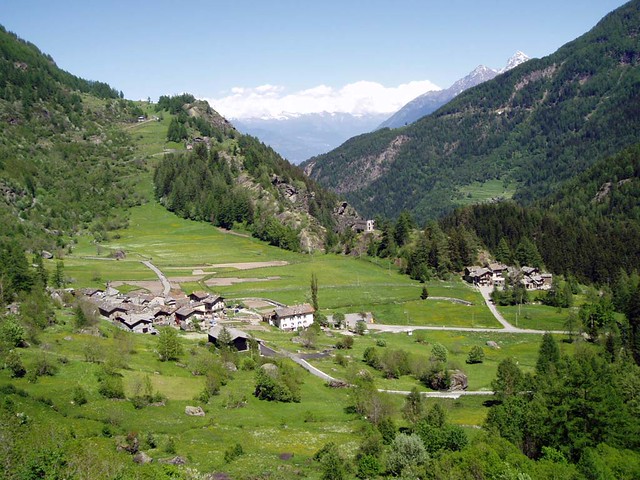
Nice to see the Massif Centrale so early on in the race, makes a change from the usual flat first weeks and it's always nice to test the GC guys' form early on, as might be the case in the stage I'm just about to post.
____________________

When announcing my Giro, I forgot to tell you about my modifications to the rulebook! In an initiative I think might help make racing more interesting, riders will be awarded bonus seconds at KoM sprint points, as long as it's not a summit finish, via the following method:

Cima Coppi: 1st: 1'00''; 2nd: 30''; 3rd: 15''
1st category: 1st: 30''; 2nd: 15''; 3rd: 10''
2nd category: 1st: 15''; 2nd: 5''
3rd category: 1st: 10''
4th category: 1st: 5''

Play this right in the break and you could find yourself gaining a minute and a half on big mountain stages and hauling yourself back into a top 10 place or something like that. It will certainly make the early stages, like this one below, interesting.


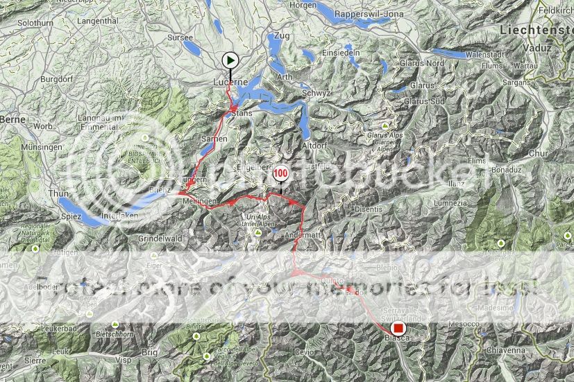
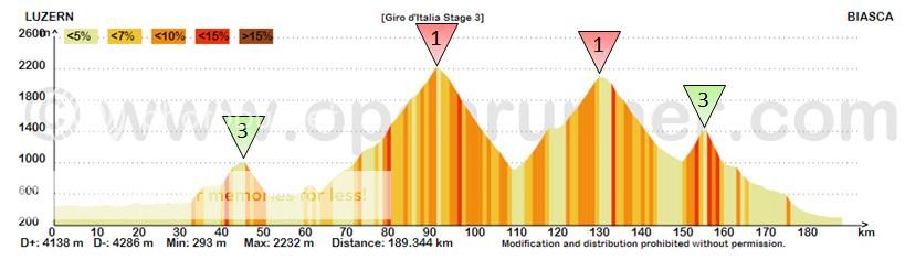
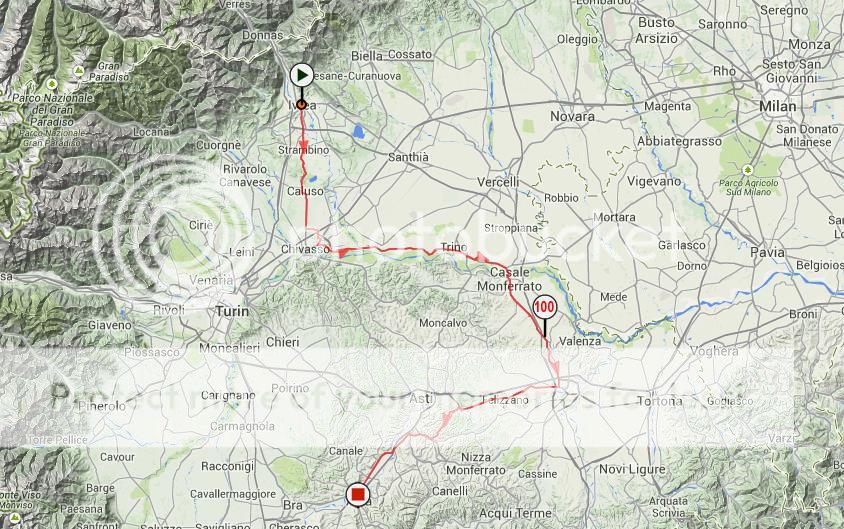
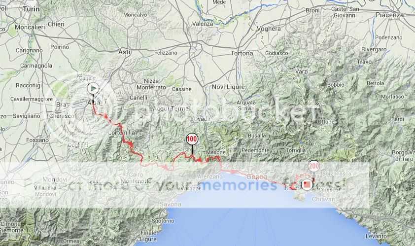
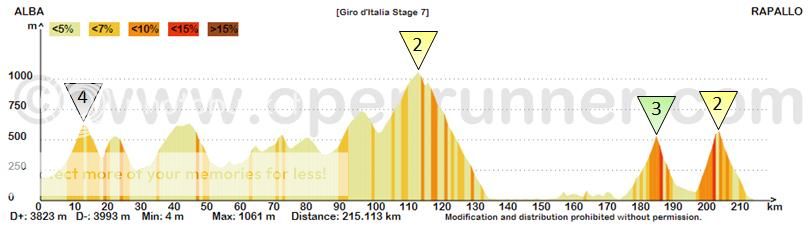
Giro d'Italia Stage 3: Luzern (SUI) - Biasca (SUI) | 189km/147km

Stage3map_zps2e5d8e23.jpg

Stage3profile_zpsb767de1c.jpg


Climb details:
Passo Brünig (cat.3; 12.5km @ 4.1%)
Passo del Susten (cat.1; 27.7km @ 5.8%)
Passo del San Gottardo (cat.1; 8.6km @ 7.1%)
Altanca (cat.3; 4.8km @ 7.5%)


I know what you're thinking. In fact I can almost sense the disapproval you've already taken towards this stage for having 2000m passes near the beginning of May, when they are closed to the public and probably covered in snow. But don't worry, everything is under control.
You see, I wanted mountains near the start of the race, and the passes in this part of Switzerland are simply too beautiful to waste. However, most of them are closed at the start of May, due to snow. So, my plan is to have something that I don't believe has been done before (and I can sort of see why, considering the headaches it would cause the organisers at the time of the race) and have a dual profile for the stage. The two profiles will be released, and, although the one posted above would be the preferred route, a decision would be taken nearer the time when there is sufficient knowledge about the weather as to which would be the best.

Stage3alternateprofile_zpseafd6a9c.jpg


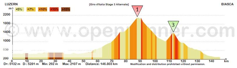
Here is the other profile by the way, travelling east from Lucerne as opposed to south, and then following the valley down to Andermatt, where it would merge with the original profile, tackling the St Gotthard pass, where the weather is likely to be slightly better. Of course if the weather is still terrible, and I mean truly terrible, the riders can take the Gotthard tunnel and the stage turns into more of a flat/hilly stage.

(Note: the funny bits at the start are tunnels which openrunner doesn't like, I have tried to blot out their hideousness from the profile, but haven't really succeeded)

Anyway, sticking with the original profile, I should give you some details of the route. We start out in Lucerne, the finishing town from yesterday, and head south into the Canton of Obwalden. We pass through the town of Sarnen, a stage finish town in this year's Tour de Suisse and then we reach the foot of the Passo Brünig/Brünig Pass, the first categorised climb of the day. Although it is harder than the average gradient of 4.1% suggests, as it is a rather irregular climb, it still should not pose many problems. Riders will probably have time to admire more pleasant views as they start the descent. After roughly 10km of valley roads, passing through Meiringen, another recent Tour de Suisse venue, we arrive at the foot of the mighty Sustenpass at Innertkirchen. This, in my opinion, is one of the most beautiful climbs [adopt suitable Jeremy Clarkson voice] in the world. Just take a look at some of these breathtaking photographs here, here, and the view from the road of the spectacular Steingletscher near the top here. Today we are climbing the longer, shallower side - at just under 28km this is a real monster in terms of length, albeit at less than 6%. Topping out at 2224m makes it the second highest pass in this Giro (not telling you what the Cima Coppi is yet! But it's a close run thing...)

Aside from a couple of hairpins near the beginning, the descent is not technical, and the riders will most probably reach some breathtaking speeds on their way down to the valley. However, there will be no time to rest and recuperate as the road starts to curve upwards as soon as they finish the descent, approaching Andermatt, a key town in the region connecting the Sustenpass, Furkapass, Oberalpass, and most importantly for the riders today, the Gotthard Pass. Today we will be climbing the less-well-known and shorter side, there are only two hairpins on this side, unlike the old road that goes up the other side. However, the riders will be spared this treachery, and instead descend the newer road, replete with hi-tech innovations like bridges and tunnels. Having reached the town of Airolo, also the starting town of the ascent of the nearby Nufenen Pass, another of my favourite passes, we start to head south down the valley towards Italy, although there is one final sting in the tail, the 3rd category climb to Altanca. Nearly 5km of gradients averaging 7.5% will certainly not be welcomed by riders who have already tackled two huge passes. Passing yet another recent Tour de Suisse venue, this time 2013's starting town/village, Quinto; we descend gradually, giving some riders a chance to recuperate, down to the town of Biasca (still not back in Italy yet!) where we finish for the day.

All stops would have to be pulled out to make this stage go ahead, and it is guaranteed that there will be snow around, but if the race were placed under my jurisdiction it will take something worse than this year's Gavia/Stelvio conditions to force the riders to take the alternate route. If the stage does go ahead, despite the long descent at the end, it could be a truly epic stage with possibility of awful weather and riders peaking for the third week as is the custom these days struggling to hold on. It could be chaos out there, especially on the Sustenpass, and it would be so easy for a contender to 'lose' the Giro today, on just the third day of racing. Add to that the fact that if a rider crosses all the passes in first position today, they could receive 1'20'' in time bonifications, more than enough to offset any losses in the previous stages, meaning the peloton might be very careful about who is left to get away - we could perhaps see a situation where a break is not allowed to get away at all and we see the GC favourites coming out to play on the Sustenpass looking for those 30 seconds that may prove crucial later on in the race.
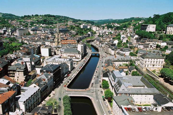

Biasca:
safe_image.php
 

Kotar_Rhakoz

BANNED
Aug 25, 2014
83
0
0
Visit site
Wow, there are a lot of good race designers here.

Having a prepared alternative bad weather route is using ones brain, it could avoid the indecision that marked the 2013 Giro when no one knew what was happening. I think it is an admirable thing to do.
 
Tour de France

Stage 6: Mende - Mont Aigoual, 182 km

xwy82l14ghux.png


fm8a64t5h5ld.png


The first mountaintop finish of this Tour comes after a quite demanding ride through the wonderful Cevennes. Col de Finiels is the first obstacle, followed by smaller climbs like Col du Sapet, Col de l'Houmenet and Col de l'Asclier. The roads here are often quite small and they are twisting and turning most of the time. The last 30 km should see the first real showdown of the gc favourites, as they climb Mont Aigoual via Col de la Lusette. Lusette is 18 km long and averages 6,5%, but as you can see from the profile the second half of the climb is much harder, with 5 km at 9,6%. It's very scenic too, with open views of the Cevennes. From the top of this first HC climb of the race, 13 km remain to the finish. After a short descent there are 4 km of flat before the final 8 km lead to the weather station on top of the mountain. These last 8 km are only 4,2% steep, so attacks make much more sense on Lusette. I'm afraid that last part of the stage is pretty identical to Another Dutch Guy's stage to Mont Aigoual, but it is simply the most logical route towards that mountain.


Mende
b94ygp2upwph.jpg


Mont Aigoual
6829626.jpg
 
Tour de France

Stage 7: Millau - Aurillac, 195 km

9w4h46v9uao.png


This transitional stage leads us back to Auvergne. The difficulties of the day lie in the first half of the stage. First the 9 km climb to Col d'Engayresque soon after the start, then Col de Bonnecombe (1.350m, 17 km 4,7%) which leads to the plateau of L'Aubrac, where we will stay for some good 60 km. L'Aubrac is quite an unusual plateau, as it is totally exposed whith only a handful of trees here and there. Should there be wind there would be nowhere to hide. Then we slowly descend from the plateau to the Gorges de la Truyère. The final 50 km are on gently rolling terrain on good, wide roads. This could be a stage for a group to stay away, but the sprinters might be motivated by the easy second part to keep the breakaway in check.


Millau
MILLAU+27+juin+2012+008.jpg


Aurillac
4934006.jpg
 
Tour de France

Stage 8: Mauriac- Tulle, 76 km ITT

k2juhpgik3bo.png


The second Sunday sees the main time trial of this Tour. 76 km may seem extraordinarily long, but in the 1980s this was a fairly standard distance. See for instance the 75 km TT from Sarrebourg to Strasbourg 1985 (won by Hinault), the 87 km Saumur - Futuroscope TT (Roche) or the 73 km stage from Dinard to Rennes 1989 (Lemond). The terrain today is mostly flat to rolling. There are some hills but the gradients are usually shallow. Panzerwagen approves, i would think. The pure climbers will lose a lot of time here, but they will get plenty of opportunities to get that time back.


Mauriac
1-Mauriac-1.jpg


Tulle
1301870192_vue.jpg
 
76km? Ouch. Special dispensation from the UCI sought and got!

As for the Mont Aigoual via Lusette stage, the only way that could be better would be if it were a day later so it'd be at the weekend, because I'd love to get the chance to see a proper, well-done Massif Central stage in the week.

Also, have fear, for another GT is coming your way from me, soon.
 
Tour de France

Stage 9: Bergerac - Mont-de-Marsan, 153 km

vu8abrrtgfw.png


The sprinters aren't having much fun with my Tour so far, but today they can't complain. A totally flat stage, an uncomplicated run-in and a finishing straight that is a couple of km long, what more could they want.


Bergerac
fdoqnhjk1kt.jpg


Mont-de-Marsan
mezp1hga6h4.jpg
 
Jul 24, 2014
150
0
0
Visit site
Red Rick said:
Love the idea of boni's on the top of the climbs, I only think they're a bit much

Hmm yes they are quite big I'll have a think about reducing them. But having a sizeable bonus in situations like the last mountain before a descent finish would make it very interesting as riders would surely attack on the final climb.

Also, yay another Libertine GT! I sense a Giro perhaps?

Anyway, back to Switzerland:
_____________________

Giro d'Italia Stage 4: Bellinzona (SUI) - Biella | 158km

Stage4map_zps5eedb436.jpg

Stage4profile_zps619bcc89.jpg


Climb details:
Passo della Colma (cat.3; 7.9km @ 5.8%)

After the madness of yesterday, things are restored to relative calm. We find ourselves back in Italy after 32km, which means of the 3,400km-ish total distance of the whole race (still got to finalise a few minor details on a couple of later stages) 397km will be spent outside of Italy - 296 of those in Switzerland.

Today will be a day for the sprinters, as, having departed from the town of Bellinzona very near the Swiss/Italian border we find ourselves rolling along in northern Piemonte. At less than 160km, it's a fairly short stage and after the riders have had a chance to take in some more of the obligatory lake vistas - this time it's the shore of Lago Maggiore that we ride along for a good 40km or so as we pass through the towns of Locarno (of the 1920s border treaty) and Verbania - we head for the only categorised climb of the day, the 3rd category Passo della Colma. At around 8km at 6%, this is one of the more difficult third-category climbs but it comes a long way from the finish and any sprinters that are dropped here, should the pace be high enough, will have plenty of time to get back on.

However, once we have headed further south through Borgosesia and swept west, passing through Cossato, we start to approach Biella, and there is a very technical run in for the trains to deal with as we get very close to the finish. A long, straight road that pitches ever so slightly uphill (the rest of the run in including the finish is all at 2-3%, just to add to the confusion) takes us into the town, but then we are confronted by five roundabouts inside the last 4 kilometres. A sharp left-hander at 1.9km to go takes us onto a bridge across the river and then, negotiating roundabouts along the way, the riders will have to take a sweeping right after the flamme rouge before the finishing straight, the Via Alfonso Lamarmora, opens up with the last 800m being gunbarrel-straight. The sprinters' teams will definitely have had to have studied the road-book closely today, positioning going into the last few km's will be absolutely crucial.

Bellinzona:
bellinzona__image.jpg


Biella:
biella-realizzazione-siti-web.jpg


I had thought about making this stage more mountainous - there are several great climbs in the area and as you probably know, Biella is the starting point of the climb up to Oropa, but, considering what came yesterday and *semi-spoiler* what is to come tomorrow (I'm sure Libertine won't have missed the fact that today's stage finishes very near the Valle d'Aosta) I thought that the riders deserved a bit of rest, and the sprinters a first good opportunity in a Giro where flat stages will be present, but spaced out.
 
The Classique des Alpes was a 1 day race rare in that it was one of very few 1-day races in the high mountains.

Going from Chambery to Aix-les-Bains over climbs such as Cucheron, Granier, Pres, Plainpalais and Mont Revard it was held between 1991 and 2004 before being discontinued due to lack of support from the teams.

The junior version of the race however is still going strong and the 20th edition was held this year taking in Mont du Chat (unfortunately via and easier route) among other climbs.

Unfortunately, with San Sebastian, Pologne, Eneco, criteriums and National Championships there is no real place in the calender for CdA as a pre-Tour or post-Tour rest.

This is a great shame, because the region provides a great variety of possible routes which would offer an interesting race.

Without further ado here is the hypothetical version of one of these routes going from Annecy to Chambery over 187 km and 8 climbs of various difficulty

25jh6py.jpg


The difficulties are the following

1. Km 17 Col de la Forclaz de Montmin

http://cyclingcols.com/profiles/ForclazDeMontminN.gif

2. Km 50 Col de Vorger

http://cyclingcols.com/profiles/VorgerN.gif

3. Km 73 Cote de Bonvillard

http://cyclingcols.com/profiles/BonvillardE.gif

4. Km 95 Col de Champlaurent

http://cyclingcols.com/profiles/ChampLaurentW.gif

5. Km 111 Col de Cochette

No profile, but 3km at 8% approximately

6. Km 132 Col de Marocaz

http://cyclingcols.com/profiles/MarocazS.gif

7. Km 155 Pas de la Fosse

http://img341.imageshack.us/img341/5979/profilpasdelafosse.png

8. Km 177 Cote de Saint-Sulpice (part of the Col de l'Epine)

http://cyclingcols.com/profiles/EpineE.gif (to the turn to la Motte-Servolex)

With the final climb having approximately only 4 "difficult" km and with 6 flat km after, eliminating the faster finishers would need to take place at Pas de la Fosse and hopefully offer an interesting final hour of the race
 
Jul 24, 2014
150
0
0
Visit site
Giro d'Italia Stage 5: Santhià - Planaval Valgrisenche | 178km

Stage5map_zpsf6daaeb9.jpg

Stage5profile_zps1e3b63b1.jpg


Climb details:
Pila (La Cerise) (cat.1; 12km @ 6.9%)
Vetan (Meod Dessus) (cat.1; 12.9km @ 7.5%)
Vens (Saint-Nicholas) (cat.3; 5.6km @ 6.6%)
Valgrisenche (Planaval) (cat.1; 10.2km @ 7.8%)

It's Stage 5 and we're back in the mountains, this time with the first of the race's three summit finishes (although technically it's not a summit finish, more on that later). Today we are heading into the Valle d'Aosta, and visiting some lesser-known climbs along the way. Starting from the town of Santhià, a little south-east of yesterday's finishing town, Biella, the riders are treated to a day of two halves. The first half presents no difficulties at all to the riders as they wend their way up the false flat of the Aosta valley, passing climbs like the Col de Joux, the Col de Saint-Pantaléon and Libertine's favourite, the Col Tze Core. Whilst it would have been nice to have these wonderful climbs in the parcours today, we have to remember that this is still the first week and it would be quite harsh to present a stage of such difficulty so early on. Nevertheless, what we have in store for them today is not exactly easy!

As we enter the town of Aosta the road turns off to the south and we start climbing, up towards the the ski resort of Pila. I say towards, because we never actually get there (infact we don't go up the full distance of any of the climbs). There are two roads up to the ski station, and they converge near a small hamlet called La Cerise. Instead of following the combined road up to Pila itself, we instead descend down the other side. The profile can be seen here - we turn off at 'bivio per Gressan' (junction/exit to Gressan), cutting 5km off the climb, making that by my calculation 12km @ 6.9%, still a difficult climb and worthy of first category status.

After a multi-hairpin descent we find ourselves back in the valley again and we cross over to the north side to tackle a rather bizarre climb. Bizarre in that it's a difficult, first-category climb on not particularly narrow roads, and I can barely find any information about it at all. When researching the stage I did finally find a link to a profile on www.zanibike.net, a very good resource if you're looking for climbs in Italy btw, but it seems to have disappeared. Anyway, I have in my notes that the climb is 12.9km @ 7.5%, as stated in the climb details above, but can't really tell you much more about it than that, other than we don't go all the way to the top of the climb, in a village called Vetan, and instead summit near a place called Meod Dessus, offering views of the Valgrisenche, where we are ultimately headed. Whatever it is, it's a hard climb, with some nasty bits at the bottom, looking at the openrunner profile, so coupled with the climb of Pila before should break the pack up a bit.
On the descent we also have to tackle a small climb up to the village of Saint-Nicolas, on the climb to Vens, before we cross the valley once more and start heading back south up to the Valgrisenche. In full it is a behemoth of a climb, lasting 23km, but the steep sections are at the bottom and once it gets past the village of Planaval, it flattens out, as you can see from this profile. So instead of finishing nearer the top, I decided to finish at the village of Planaval, about halfway up which, incidentally, hosted the start of this year's Giro della Valle d'Aosta, the U23 race, with a slightly odd prologue, that continued further up the valley. Cutting out the shallower gradients further up the climb, leaving it at 10.2km @ 7.8% instead of 22.6km @ 4.5% will probably make for some more interesting racing, it also means that the 'Vetan' and 'Vens' climbs, as I have dubbed them, are not too far out from the finish.

All in all, it should make for an interesting stage and we shall certainly see the favourites attacking each other - hopefully before the final climb but more likely on the steep slopes of Valgrisenche. After all, it is one of only 3 summit finishes in the race and with a decent amount of TT kms the climbers will have to maximise all opportunities they are given.
Also, apart from Pila, none of these climbs have been used in the Giro before (?) and Pila was last used more than twenty years ago, so if nothing else I'm at least introducing a bit of variety in the route.

Santhià:
Via%20Francigena%20Ivrea-Santhia%20(2)_display.jpg


Planaval:
7241589688_0a6ab5635a_z.jpg
 
It is always acceptable where the Valle d'Aosta is concerned to throw in Tze Core :)

I think your Meod-Dessus climb is actually called Verrogne at the summit you're using. I can't find a profile by that route, however salite.ch has a different, two-stepped profile from Aosta via Arpuilles. In my Giro in the Pila-Ciel-Bleu finish I climbed the two ascents in the opposite direction, so as to descend into Aosta.
 
Can you help me find a good mapping site? I have been using MapMyRide since ever, even when T4B was still working properly, but now the profiles come all messed up, full of terrain irregularities which increases the elevation gain to absurd levels. I see OpenRunner looks good, any other sugestions? Thank you.
 
BigMac said:
Can you help me find a good mapping site? I have been using MapMyRide since ever, even when T4B was still working properly, but now the profiles come all messed up, full of terrain irregularities which increases the elevation gain to absurd levels. I see OpenRunner looks good, any other sugestions? Thank you.

I use open runner as the profiles look pretty decent and accurate.
 
I map with bikeroutetoaster as I think it's the best and easiest to map with (most of the time, grrr) then I export the track and upload it to openrunner to get a nice profile.

T4B still do the best profiles, but unfortunately they don't have an upload feature with the new version.
 
Pricey_sky said:
I use open runner as the profiles look pretty decent and accurate.

Netserk said:
I map with bikeroutetoaster as I think it's the best and easiest to map with (most of the time, grrr) then I export the track and upload it to openrunner to get a nice profile.

T4B still do the best profiles, but unfortunately they don't have an upload feature with the new version.

Thank you both. I think I'll do as you say Nets.
 
Jul 24, 2014
150
0
0
Visit site
Libertine Seguros said:
It is always acceptable where the Valle d'Aosta is concerned to throw in Tze Core

I think your Meod-Dessus climb is actually called Verrogne at the summit you're using. I can't find a profile by that route, however salite.ch has a different, two-stepped profile from Aosta via Arpuilles. In my Giro in the Pila-Ciel-Bleu finish I climbed the two ascents in the opposite direction, so as to descend into Aosta.

Thanks for the info, I'd forgotten you'd done those two climbs in your Giro.

____________________

Giro d'Italia Stage 6: Ivrea - Alba | 162km

Stage6map_zps76903120.jpg

Stage6profile_zps3086b4c5.jpg


Climb details:
Montaldino (cat.4; 6.9km @ 2.2%)

After the mountains of yesterday, we have a very flat stage taking us away from the Alps and down towards Liguria. The sprinters will want to take full advantage of today as their next opportunity will come on Tuesday (this being Thursday).

Not a lot to say about this stage, really. We start in Ivrea, the gateway to the Valle d'Aosta, and a finish town in last year's Giro, where we finished yesterday, and head south for about 30km before turning left just before we reach Turin. We carry along the Po river until Casale Monferrato, where we turn back south and head down to Alessandria. Having turned west from here towards Asti, we come off the A-road for a small climb to Montaldino that is basically a false flat, but I felt that the attackers merited some sort of reward for being so foolish as to get in the break today so I gave it cat.4 status. We continue south on a long straight road before we get to Alba and another rather technical run-in, with 5 roundabouts in the last 3km. We turn left as we approach the town to cross the Tanaro river, before completing a rather drawn-out chicane and then finally turning right just before we go under the flamme rouge, and then the rest is a long straight to the finish.

Ivrea:
11.jpg


Alba:
Alba_italy.jpg
 
Jul 24, 2014
150
0
0
Visit site
Giro d'Italia Stage 7: Alba - Rapallo | 215km

Stage7map_zps8109eb15.jpg

Stage7profile_zps77f94ad8.jpg


Climb details:
Bricco (cat.4; 4.7km @ 5%)
Passo del Faiallo (cat.2; 12km @ 4.6%)
Uscio (cat.3; 10.3km @ 3.8%)
San Maurizio di Monti (cat.2; 6.5km @ 7.9%)

The longest stage of the Giro so far, and in fact the fourth-longest in the race, takes us from yesterday's finishing town of Alba to the Ligurian coast, and a finish in the town of Rapallo. I expect that this stage will probably be won by the breakaway as there will be riders who will have lost enough time in the Swiss Alps and up to Planaval that the pack will let them go.

The stage can be split into two halves. The first half is rolling terrain as we head southwards towards the coast. The first categorised climb, to Bricco, starts almost from the gun, but is a fairly gentle climb at around 5% for its 4.7 kilometres. After this, there is not a lot of flat as the road constantly rises and falls as we take in some scenic Ligurian countryside, although none of it steep enough or long enough to merit categorisation. That is, until we hit the Passo del Faiallo, the first of two second-category climbs today (although it is borderline 2nd/3rd cat). This climb is not steep, at under 5%, but it is 12km long. It's also quite a scenic climb. From the top, at just over 1000m, we commence a rather steep but not too technical descent, before linking up with the famous Passo del Turchino about halfway down and continuing on to the coast.

This marks the start of the second half of the race, flat along the coast with a couple of important interruptions nearer the end. The riders pass through the city of Genoa, which you might think would be a good place to finish for today, but we carry on further along the coast.
Soon we arrive at the town of Recco, and turn sharply left to start the penultimate ascent, which I have named Uscio after the .jpg]village at the top. In the climb details it is listed as being at a 3.8% average but this really does not do it justice. It's one of those climbs that starts at a very shallow gradient but then ramps up, and here the last 3km are at around 7-8% average. We then plunge down a very steep and rather technical descent, with several hairpins following close after each other.

We turn right as we get to the valley and continue along for around 6km before turning right again and starting the ascent to San Maurizio di Monti. This is a very hard climb, averaging 8% for the duration of its 6.5km, and with a nasty section of over 10% at the top. Even if a break is allowed away to fight for the stage win, this gives a really good springboard for a GC favourite with a punch to gain some time. I could quite easily see someone like Nibali gaining 10-15 seconds on the climb and holding or even extending that gap on the descent, which is technical enough to let good descenders display their skills. The finish itself, coming straight off the descent, is preceded by several tight 90-degree turns in the outskirts of the town, just to complicate things if it does come down to a select sprint.

With the summit of the climb just 11km from the finish, I would be surprised if no one attacked, but looking at what is to come tomorrow and Sunday on a couple of interesting weekend stages, they might want to save a little energy.

Rapallo:
rapallo.jpg
 
As recently threatened... I am starting another GT. Slightly ironic given the brief exchange I just had with Echoes about this thread being dominated by stage racing, I guess.

I do have a second Tour in the works & I know that I have only had one attempt at a Giro - and there are just so many options in Italy it's nigh on impossible to work out which ones to use. Which just leaves the one that's going on right now. It is also true that I have already had no fewer than three attempts at a Vuelta, in addition to this very wordy thread about the unused monoliths of Spain. The first attempt was a comparatively traditional route taking in several of the race's most supportive cities; the second was a highly experimental route which featured two MTFs on stages 3 & 4, 7 stages not on the Spanish mainland (2 in the Balears, 2 in the African exclaves & 3 in Las Canarias) & other general weirdness. The third attempt tried to return to a bit of a more sensible Vuelta route.

This fourth attempt is a further attempt at uniting the traditions of La Vuelta with a touch of experimentation; there are a few stages in a style that Unipublic would be unlikely to use, there are innovations, there are also no major summit finishes already seen in any of my previous routes, and few key passes that have been seen already at all in fact. Inspired by this year's route (!) the finish is not in Madrid. Yet, I have used some of the race's hallowed grounds, supportive cities and regions & also there are some nods to a few stages in the race in recent years.

But first, we begin with arguably the biggest innovation of the race.

Stage 1: Casablanca (Marruecos) - Casablanca (Marruecos), 12,9km (CRI)

2n0ub6q.png


9ay7o4.png


While the Giro has been into pretty much every neighbouring country and then some (exception: Vatican City?), and Le Tour has been into every country that borders the French state (except for Suriname and Brazil, due to French Guiana), the Vuelta's trips abroad have been infrequent. In fact, it has only begun outside Spain twice (Lisbon in 1997 and Assen in 2009), and has only visited the neighbouring countries of France and Andorra (Portugal is a real rarity, although non-contiguous parts of Spain have been visited occasionally, with Mallorca being visited in 1975, 1986, 1991 & 1998, and the 1988 départ in the Canaries. Which leaves two countries that Spain borders that La Vuelta has yet to visit. One is the United Kingdom, thanks to Gibraltar, and the other is Morocco.

With the UCI looking to develop cycling in Africa, a major race there is not too far-fetched. Morocco does at least have some cycling heritage, with its continual success on the UCI Africa Tour, and of course those who talk of Chris Froome as trailblazing for Africans despite his racing for an adopted European homeland may forget that Richard Virenque was born in Casablanca... you could argue that a problem with such a route is that the Moroccans will perhaps not have much in the way of home interest to cheer for. That would indeed be something of a shame, although it would be interesting if Sky Dive Dubai were to follow up on their threats of trying for a ProContinental licence. After all, they have some of the best Moroccan riders on their squad. With Algeria also having a few useful representatives on teams like MTN, a small North African presence would make for interesting viewing. I would certainly like to see what some of the riders there could do in higher level races - I know Tarik Chaoufi was helplessly out of his depth last year, but 2013 Euskaltel as an outsider was not a place for development, and obviously I am not suggesting we take a team of riders like Soufiane Haddi, Essaïd Abelouache and Mouhssine Lahsaini and stick them straight into the World Tour (also the somewhat older Adil Jelloul, who has been a big gun in small races for several years now), and this would likely need to be at the end of a longer development project.

Anyway. I am well aware that heat is often an issue when the Vuelta starts in southern Spain due to the time of year. Casablanca is, however, surprisingly cool due to the effects of Atlantic currents which moderate temperature swings - in fact 40,5ºC is the record in the city - it was 45º at the start in Pamplona in 2012 (I can vouch for that), and so this will actually be easier to deal with than a start further north, paradoxically.

The stage itself is a pretty simple out-and-back type ITT route slightly too long to be a prologue, and designed for the pure power rouleurs. The climbers will already be placed on the back foot, especially if the wind blows in from the Atlantic as the riders will be side on to it almost throughout.

The start and finish are on opposite sides of the road at Casablanca Marina, an ongoing redevelopment project that will eventually turn this land by the port into the Monaco of Africa. The project is nearing completion but is a bit behind schedule. Nevertheless, the completed site will be a sight to behold. At the beginning of the stage the riders will pass through a tunnel beneath the Hassan II Mosque, one of the city's most iconic structures since its opening in 1993 and the largest mosque in Africa. They will then enjoy the sights of the Boulevard de la Corniche, a broad seafront boulevard lined with palm trees, until reaching the suburb of Aïn Diab with its famous beach. The riders will then double back on themselves and return along the corniche, with the incredibly scenic mosque filling their views, although on the way back the riders will circumnavigate the outside of the Mosque before returning to the Marina for the finish of the TT.

Boulevard de la Corniche:
casblancacorniche.jpg


Hassan II Mosque:
Casablanca_city.jpg
 

TRENDING THREADS