Stage 12: Martigny (CH) - Aosta (IT), 248km
Climbs:
Col du Grand-Saint-Bernard (HC) 30,6km @ 5,7%
Col Tze Core (HC) 16,0km @ 7,6%
Col du Saint-Panthaléon (HC) 17,1km @ 6,5%
Col de Champremier (cat.1) 9,7km @ 8,6%
Pila-les Fleurs (cat.1) 12,0km @ 6,9%
Intermediate Sprint:
Châtillon, 146km
This is the introduction of the Alps, a very strange stage which will naturally require some explanation. At a UCI-baiting length of almost 250km, with five climbs of either 1st or hors categorie, reaching altitudes of 2400m, this could easily be argued to be the queen stage of the race... yet, it comes before the penultimate weekend (this will be the second Friday of the race), there is no MTF, the route doubles back on, and criss-crosses, itself, the favourites are quite likely to come to the line together, the stage could well be taken by the breakaway and, perhaps most controversially,
not one kilometre is in France.
It is perhaps because of the last point that I have elected to go with the descent finish here; there are tougher finishes coming in the stages to follow. I also feared that with some of the stages to come this stage would be soft-pedalled until the end if I put an MTF in; with this design even if the bunch tries to go easy, the sheer brutality - we could be talking almost eight hours in the saddle - will ensure that a) attrition will shatter the bunch so that any pretenders will be certainly selected; b) it is highly unlikely any of the favourites will have any helpers left by the time we get to the final climb, so fireworks can happen; c) in the weekend stages, the fatigue factor will be a major player, increasing the likelihood of significant gaps emerging in the stages that follow.
It can't have escaped even the least eagle-eyed follower of this thread that I am a big fan of the Valle d'Aosta for racing; you have a lot of tough climbs all very close to one another, scenery is incredible, and it is tackled rarely enough by the professional péloton that it feels special when you get a stage through there. The last time the Tour went there was 2009, when we got
a stage that started like today's, before re-entering France via the Petit-St-Bernard pass, a real tempo-grinder of a climb much unlike the other climbs the riders face on this stage. This was also the last time we saw a mountain stage entirely outside France, thanks to the one-climb Verbier stage.
After the start in Martigny, the stage is likely to follow the pattern of the 2009 stage, after all the first 75km are exactly the same; the difficulty of the Grand-St-Bernard pass will ensure a strong breakaway, and a lot of stagehunters will want to be in it - GC men who've lost time in the Vosges or the cobbles, secondary contenders, domestiques for GC men to ride across to, maillot vert contenders with climbing chops trying to get a head start on the grupetto, we could easily see 25-30 riders up the road. Altitude will also play a big part; this monstrous ascent gets up to almost 2500m over a strength-sapping length of
over 30km, with the last 5km averaging nearly 9%. This is not going to be fun at all, and even when it's over and the riders pass the
beautiful lake and hospice at the summit and cross from Switzerland to Italy there are more than 200km remaining!
The descent is just as long and drawn out as the climb, and especially early on features some stern technical tests. After the descent the riders head past Aosta, the finish town, and head east on the
SS26, one of the most scenic nodal roads in all of Italy (which is saying something). We pass Chambave, Châtillon and
Montjovet before we start climbing again after a respite of about 35km flat. The first up is one of my favourite climbs, the
Col Tze Core. Despite how much the Col du Grand-St-Bernard dwarfs it on the profile above, this is very much a bona fide HC climb, averaging over 7,5% for 16km; the first half is the same as the Estoul and Col de Joux climbs, but after that it gets super brutal; the scenery however is
some of the best in the world, although at this point the riders are doing 2km at 12% so they probably won't notice. The road
narrows down and there are some steep lacets here. The summit comes with 120km remaining (!) and then there's a
difficult descent into Châtillon (which you can see in the distance on that photo). The town is
beautifully located, both in general and specifically in relation to this stage, where it hosts the intermediate sprint, before we head for the Valtournenche. This road leads eventually to Breuil-Cervinia, familiar from the Giro, and to the legendary
Monte Cervino, aka the Matterhorn, however at Antey-St-André we turn left to ascend another legendary climb of the Valle d'Aosta, the
Col du Saint-Panthaléon. Slightly longer but noticeably less steep than Tze Core, I wrestled with whether this should be HC or cat.1 but decided HC was appropriate given its length and the 6km @ 8% which come after a full cat.2 climb preceding it.
Winding through the hillside, this tough ascent is the opposite side to that normally tackled by the Giro, however it was seen in the Giro delle Valle d'Aosta a couple of years ago in a tough stage to Torgnon (so effectively climbing it twice as Torgnon is a station 3/4 the way up the climb). We then descent the Chambave side familiar to the Giro, still
scenic, after topping out the climb with 84km remaining.
We then cross over the road we took earlier in the stage before starting the next climb, the steepest of the day, but significantly shorter than the preceding ones. The climb to
Champremier, the pass just before the 10km mark on that profile, is relentless; after the easy first kilometre it is between 9 and 11% almost all the way. The steepest kilometre is at almost 11% halfway up, and there are also dozens of hairpins on the narrowest climb of the day as well. The views, when the riders escape the forest, are
stunning, and with just 53km remaining at the summit of this one I anticipate this being where we lose many of the day's domestiques from the top teams - after all nearly 200km are gone by the time we get here. The descent is very technical; it is wide enough but some parts might need a new coat of asphalt before the Tour arrives. Nevertheless, that will add to the challenge before the glorious respite of ten flat kilometres.
Then, it's time for the final climb of the day.
Pila is perhaps the most celebrated ski resort in the Valle d'Aosta (outside Courmayeur, I guess), and the combination of its convenient location above the region's capital and its
difficult and irregular climb make it fodder for course designers, both traceurs and real life race organizers. The St-Panthaléon-Champremier-Pila combo featured in the
1992 Giro, for example. However, a big MTF here would only render the rest of the stage pointless and neutralized; we're going to descend. Therefore I can only climb as far as the intermediate station at
Les Fleurs. This is still a more than considerable climb - 12km @ 7% - with the last 2km being false flat! There is a kilometre averaging 11%, and seeing as the domestique assistance to the heads of state should be minimal by this point, groups should be splintered all over the road now. And with the summit being 17km from the end of the stage this really needs to see pressure being put on. The stage will be attritional to this point, and there are further brutal stages to come, but this is where it should all go haywire. After this there is a simple descent by the easier Gressan road, before a picturesque finish as the riders head through the cobbled streets of Aosta's pedestrianized old town and finish in front of the town hall at
Piazza Émile Chanoux.
Possibly the most brutal Tour stage in years. The mountains are well and truly here.
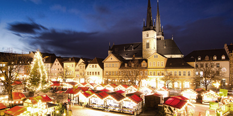
Martigny:
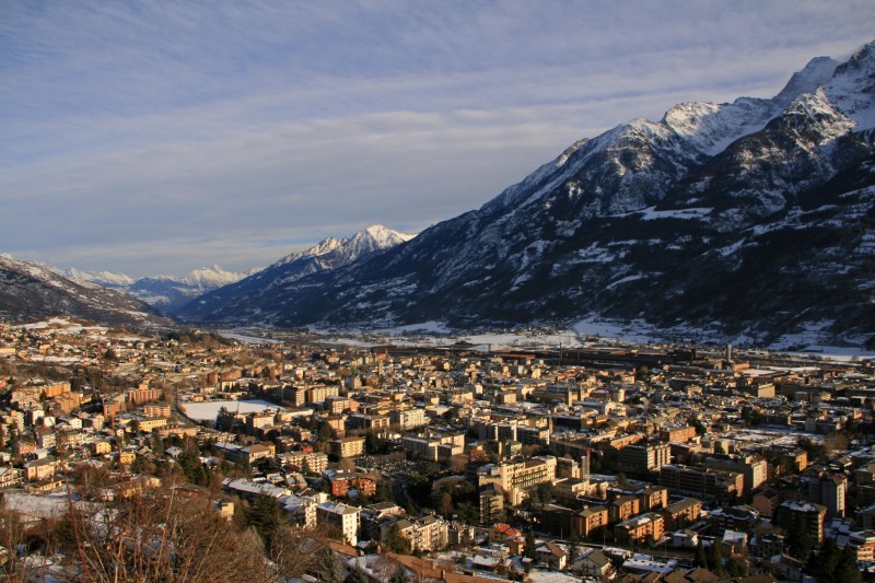
Aosta: