
Race Design Thread
Page 181 - Get up to date with the latest news, scores & standings from the Cycling News Community.
You are using an out of date browser. It may not display this or other websites correctly.
You should upgrade or use an alternative browser.
You should upgrade or use an alternative browser.
- Feb 18, 2015
- 13,913
- 10,041
- 28,180
DACH Rundfahrt stage 12: Mariazell - Red Bull Ring (158 km)
difficulty: **


Although the second week will become brutal, soon enough, the sprinters also get another chance. This is a transitional stage, with only one climb, but a pretty interesting finish.
The start is in Mariazell, which means no transfer. As you can see it on the map (I decided to post the terrain map, because you simply get a better impression of the area the riders are in) the riders drive through a very mountainous area, but I tried to avoid all the climbs in this area. There are only some little bumps like the Radstadthöhe. The problem with Austria is that I could do mountain stages almost everywhere but when I have to decide if I want to use the climb in Tyrol (west of the country) or the climbs in this area, I surely go for Tyrol. After 84 kilometers the riders have an intermediate sprint in Eisenerz, followed by the first and only categorized climb of the day, the Präbichl. On the way up there the riders will pass the Erzberg, a very famous mine, which is now also used for events like the Erzbergrodeo, one of the most crazy motocycle races on earth.

Präbichl isn't one of the hardest climbs in Austria, but it can be used pretty well. Its neither flat nor very steep, but combined with its length I'd say its a 2nd category climb.

After the descent and some false downhill there is another intermediate sprint, this time in Leoben. From there on there are only about 40 kilometers left. These 40 k's are more or less flat but the biggest bump of this part is only about 3 kilometers away from the finis line, and its already on the Red Bull Ring, Austria's most famous car racing track. As I've already mentioned it, this circuit would work pretty good for a finish of a cycling race because of the ascent at the beginning of the lap.

However I'd still expect a bunch sprint simply because the sprint teams will try to get every chance they get in the last two weeks because there simply aren't that many. Moreover the climbs in this stage aren't hard enough anyway to cause a real selection.
Red Bull Ring:

difficulty: **
Although the second week will become brutal, soon enough, the sprinters also get another chance. This is a transitional stage, with only one climb, but a pretty interesting finish.
The start is in Mariazell, which means no transfer. As you can see it on the map (I decided to post the terrain map, because you simply get a better impression of the area the riders are in) the riders drive through a very mountainous area, but I tried to avoid all the climbs in this area. There are only some little bumps like the Radstadthöhe. The problem with Austria is that I could do mountain stages almost everywhere but when I have to decide if I want to use the climb in Tyrol (west of the country) or the climbs in this area, I surely go for Tyrol. After 84 kilometers the riders have an intermediate sprint in Eisenerz, followed by the first and only categorized climb of the day, the Präbichl. On the way up there the riders will pass the Erzberg, a very famous mine, which is now also used for events like the Erzbergrodeo, one of the most crazy motocycle races on earth.
Präbichl isn't one of the hardest climbs in Austria, but it can be used pretty well. Its neither flat nor very steep, but combined with its length I'd say its a 2nd category climb.
After the descent and some false downhill there is another intermediate sprint, this time in Leoben. From there on there are only about 40 kilometers left. These 40 k's are more or less flat but the biggest bump of this part is only about 3 kilometers away from the finis line, and its already on the Red Bull Ring, Austria's most famous car racing track. As I've already mentioned it, this circuit would work pretty good for a finish of a cycling race because of the ascent at the beginning of the lap.
However I'd still expect a bunch sprint simply because the sprint teams will try to get every chance they get in the last two weeks because there simply aren't that many. Moreover the climbs in this stage aren't hard enough anyway to cause a real selection.
Red Bull Ring:
- Oct 4, 2015
- 417
- 1
- 3,030
Giro d'Italia Stage 9: Tolmezzo - Brunico/Bruneck, 166km (****)


Climbs: Cima Corso (8,2km @ 4,2%), Passo della Mauria (10,1km @ 4,2%), Passo di Sant'Antonio (8,4km @ 7,6%), Passo di Croce Comelico (9km @ 4,5%), Passo Furcia (10,1km @ 7,1%)
The first sunday of the race we have a mountain stage between Tolmezzo and Brunico, with five climbs (two of them low-end cat.1 climbs) along the way, although most of them come early on the stage.
The first two climbs (Cima Corso and Passo della Mauria) are very gradual, serving as a warm-up for the riders. The third climb, Sant'Antonio, is more serious, with its middle 5km at almost 10%, although it still comes in the first half of the stage
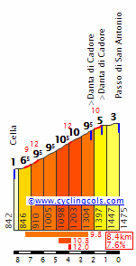
Right after Sant'Antonio comes the gradual climb to Croce Comelico (from km 10,9 in the profile below), a far more manageable climb, followed by a lengthy descending false flat section.
After this, the riders take on the key climb of the stage, Passo Furcia. An irregular climb, with two distinct sections at around 9% separated by a flat km. Any big uphill attacks (for the stage or for GC time) will have to hapen here.
A good descender may also try something in the final climb's descent, as they head towards the goal in Brunico. However, there's still a stage left before the rest day - and it's a big one, featuring the third and hardest summit finish of the entire race, so GC riders might try to save up strength for that. The stage itself should go to a breakaway.
Climbs: Cima Corso (8,2km @ 4,2%), Passo della Mauria (10,1km @ 4,2%), Passo di Sant'Antonio (8,4km @ 7,6%), Passo di Croce Comelico (9km @ 4,5%), Passo Furcia (10,1km @ 7,1%)
The first sunday of the race we have a mountain stage between Tolmezzo and Brunico, with five climbs (two of them low-end cat.1 climbs) along the way, although most of them come early on the stage.
The first two climbs (Cima Corso and Passo della Mauria) are very gradual, serving as a warm-up for the riders. The third climb, Sant'Antonio, is more serious, with its middle 5km at almost 10%, although it still comes in the first half of the stage
Right after Sant'Antonio comes the gradual climb to Croce Comelico (from km 10,9 in the profile below), a far more manageable climb, followed by a lengthy descending false flat section.
After this, the riders take on the key climb of the stage, Passo Furcia. An irregular climb, with two distinct sections at around 9% separated by a flat km. Any big uphill attacks (for the stage or for GC time) will have to hapen here.
A good descender may also try something in the final climb's descent, as they head towards the goal in Brunico. However, there's still a stage left before the rest day - and it's a big one, featuring the third and hardest summit finish of the entire race, so GC riders might try to save up strength for that. The stage itself should go to a breakaway.
- Feb 20, 2010
- 33,248
- 15,774
- 28,180
Stage 12: Castro Urdiales - Santillana del Mar-Cuevas de Altamira, 158km


GPM:
Puerto de Alisas (cat.2) 8,7km @ 5,8%
Alto del Caracol (cat.2) 13,1km @ 4,6%
Alto de La Capía (cat.3) 3,9km @ 8,0%
After the saw-toothed agony of the Basque stage yesterday, we have a shortish intermediate stage through Cantabria, which is probably well suited to a breakaway but the GC riders will have their opportunities to take a few seconds here or there in it. The finish being an uncategorized uphill follows on from other similarly styled mid-race Cantabrian stages in recent years, such as 2008's stage to Suancés in which Valverde fell off the back of the bunch grabbing a rain jacket when the bunch split, and Paolo Bettini grabbed his final career victory on the closing ramp, or 2013's stage to Parque Cabarceno, which came to a group charge on the final ramps; Dani Navarro took the win by a few seconds from Moreno and Kelderman, with Valverde then outsprinting Nacer Bouhanni (a double wtf, first Valverde outsprinting Nacer, and Nacer being there in the first place). So there's precedent for the stage and a combination of potential outcomes, though I still think the break winning is the most likely.
Castro Urdiales is a scenic coastal town in eastern Cantabria, close to the border with País Vasco, and indeed it is a town which competes successfully in estropadak; there are a few Cantabrian teams that compete, but typically it is most successfully undertaken by the Galicians and Basques. It's a popular town in summer owing to its attractive beaches, but here it's just a launchpad for the stage after a short transfer from Bilbao. The possibilities to make a really tough stage here are almost limitless, however I don't want to make the stage so hard that it kills the action in the Bilbao stage, so this one is comparatively short and only uses a small number of climbs in the region so that it has banana skins without being a killer stage that affects the racing days around it. Hence we open up with a couple of uncategorized climbs that are difficult, leg-breaking rhythm killers that will hopefully ensure an interesting breakaway in the early action, but then they give way to a long period of flat.
The first real ascent of the day is the comparatively consistent, classic climb of the Puerto de Alisas. Wide, well-paved, with some scenic lacets, it has been a feature of the Vuelta stages in the region since the 70s. Most recently, it has been used as a lead-in climb to Peña Cabarga, the current belle of Cantabrian cycling, after hosting the Vuelta in 2010, 2011 and 2013, as one of the summit finishes closest to a major population centre, short enough to be readily accessible without a car but steep enough to cause gaps. However, we're a long way from the finish, so Alisas' far more consistent slopes are unlikely to have much effect in the long run; anyhow, instead of heading toward the coast for the climb, when we reach Liérganes we switch back southward to take on another less steep but more drawn-out climb, the two-climb link that is the Alto del Caracol.
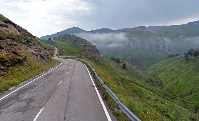
It's another Vuelta classic, this one, having featured in a great many stages over the years. Being more gradual but having those kilometres at 7-8% near the end, this cresting around 55km from the line is unlikely to create much impact but could sort wheat from the chaff with yesterday's stage in the legs, meaning that on the last climb of the day some of the bigger names could find themselves isolated. I expect the main thing here, however, will be that the breakaway will splinter. The slopes of the short but steep Alto de La Capía ramp all the way up to 23%, and will be reminiscent of some of the hell-slopes of yesterday.
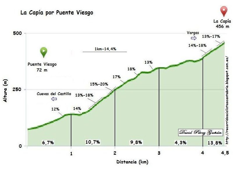
(of that profile, only the first 3,9km are raced here). There are some really nasty ramps on this one and, cresting with just inside 22km remaining, somebody might be tempted on that 20% section, after all there will be tired legs in the péloton and there's an easier day to come shortly. The run-in after the steep climb to La Capía is not so easy either, however, as the first thing the riders do after the descent is start climbing again on the uncategorized climb of the Alto de La Montaña - however, this is fairly consistent and averages just 4,5% for 3km with no steeper ramps so shouldn't be anticipated to break things up - however, from the breakaway it may make a useful point to go solo, cresting with 14,7km to the finish, especially given the temptation of the bonus sprint in Torrelavega at 10km from home. After passing through the city, it's just a rolling hit for home with the slight and inconsistent drag up through the historic town of Santillana del Mar, which includes a stretch of cobbles:

After the town we have a slight drag up to the UNESCO World Heritage site that is Cuevas de Altamira, fabled for the Paleolithic cave paintings. In addition to the paintings it's a fascinating place for the geological features anyway, not that the riders will care since they'll be above ground of course. Altamira does have some cycling heritage as well, hosting the national time trial championships when Torrelavega's region hosts the nationals, most recently in 2009 (Contador won; the road race was held with an MTF at Cueva el Soplao, won by Rubén Plaza) and 2004 (José Iván Gutiérrez won; Cabarceno hosted the road race, won by Paco Mancebo). In addition to this, the Museo de Altamira (at the Caves, same location as we're finishing) hosted a finish in the 2006 Vuelta, however it was in a pretty anæmic stage that was taken by Sérgio Paulinho from the break. The break should take this one again, but there's the chance that the group don't all take the same time like they did back then...

GPM:
Puerto de Alisas (cat.2) 8,7km @ 5,8%
Alto del Caracol (cat.2) 13,1km @ 4,6%
Alto de La Capía (cat.3) 3,9km @ 8,0%
After the saw-toothed agony of the Basque stage yesterday, we have a shortish intermediate stage through Cantabria, which is probably well suited to a breakaway but the GC riders will have their opportunities to take a few seconds here or there in it. The finish being an uncategorized uphill follows on from other similarly styled mid-race Cantabrian stages in recent years, such as 2008's stage to Suancés in which Valverde fell off the back of the bunch grabbing a rain jacket when the bunch split, and Paolo Bettini grabbed his final career victory on the closing ramp, or 2013's stage to Parque Cabarceno, which came to a group charge on the final ramps; Dani Navarro took the win by a few seconds from Moreno and Kelderman, with Valverde then outsprinting Nacer Bouhanni (a double wtf, first Valverde outsprinting Nacer, and Nacer being there in the first place). So there's precedent for the stage and a combination of potential outcomes, though I still think the break winning is the most likely.
Castro Urdiales is a scenic coastal town in eastern Cantabria, close to the border with País Vasco, and indeed it is a town which competes successfully in estropadak; there are a few Cantabrian teams that compete, but typically it is most successfully undertaken by the Galicians and Basques. It's a popular town in summer owing to its attractive beaches, but here it's just a launchpad for the stage after a short transfer from Bilbao. The possibilities to make a really tough stage here are almost limitless, however I don't want to make the stage so hard that it kills the action in the Bilbao stage, so this one is comparatively short and only uses a small number of climbs in the region so that it has banana skins without being a killer stage that affects the racing days around it. Hence we open up with a couple of uncategorized climbs that are difficult, leg-breaking rhythm killers that will hopefully ensure an interesting breakaway in the early action, but then they give way to a long period of flat.
The first real ascent of the day is the comparatively consistent, classic climb of the Puerto de Alisas. Wide, well-paved, with some scenic lacets, it has been a feature of the Vuelta stages in the region since the 70s. Most recently, it has been used as a lead-in climb to Peña Cabarga, the current belle of Cantabrian cycling, after hosting the Vuelta in 2010, 2011 and 2013, as one of the summit finishes closest to a major population centre, short enough to be readily accessible without a car but steep enough to cause gaps. However, we're a long way from the finish, so Alisas' far more consistent slopes are unlikely to have much effect in the long run; anyhow, instead of heading toward the coast for the climb, when we reach Liérganes we switch back southward to take on another less steep but more drawn-out climb, the two-climb link that is the Alto del Caracol.
It's another Vuelta classic, this one, having featured in a great many stages over the years. Being more gradual but having those kilometres at 7-8% near the end, this cresting around 55km from the line is unlikely to create much impact but could sort wheat from the chaff with yesterday's stage in the legs, meaning that on the last climb of the day some of the bigger names could find themselves isolated. I expect the main thing here, however, will be that the breakaway will splinter. The slopes of the short but steep Alto de La Capía ramp all the way up to 23%, and will be reminiscent of some of the hell-slopes of yesterday.
(of that profile, only the first 3,9km are raced here). There are some really nasty ramps on this one and, cresting with just inside 22km remaining, somebody might be tempted on that 20% section, after all there will be tired legs in the péloton and there's an easier day to come shortly. The run-in after the steep climb to La Capía is not so easy either, however, as the first thing the riders do after the descent is start climbing again on the uncategorized climb of the Alto de La Montaña - however, this is fairly consistent and averages just 4,5% for 3km with no steeper ramps so shouldn't be anticipated to break things up - however, from the breakaway it may make a useful point to go solo, cresting with 14,7km to the finish, especially given the temptation of the bonus sprint in Torrelavega at 10km from home. After passing through the city, it's just a rolling hit for home with the slight and inconsistent drag up through the historic town of Santillana del Mar, which includes a stretch of cobbles:
After the town we have a slight drag up to the UNESCO World Heritage site that is Cuevas de Altamira, fabled for the Paleolithic cave paintings. In addition to the paintings it's a fascinating place for the geological features anyway, not that the riders will care since they'll be above ground of course. Altamira does have some cycling heritage as well, hosting the national time trial championships when Torrelavega's region hosts the nationals, most recently in 2009 (Contador won; the road race was held with an MTF at Cueva el Soplao, won by Rubén Plaza) and 2004 (José Iván Gutiérrez won; Cabarceno hosted the road race, won by Paco Mancebo). In addition to this, the Museo de Altamira (at the Caves, same location as we're finishing) hosted a finish in the 2006 Vuelta, however it was in a pretty anæmic stage that was taken by Sérgio Paulinho from the break. The break should take this one again, but there's the chance that the group don't all take the same time like they did back then...
- Oct 4, 2015
- 417
- 1
- 3,030
Giro d'Italia Stage 10: Brunico/Bruneck - Rettenbachferner (Austria), 151km (*****)


Climbs: Monte Giovo (15,1km @ 7,6%), Passo del Rombo (29km @ 6,2%), Rettenbachferner (11,9km @ 10,8%)
Stage 10 may be a short stage... but it's an extremely hard one. No rest for the final 100km, three very hard cat.1 climbs, and a brutal summit finish at a high altitude.
There are only 50kms of respite early on, before the first of the big climbs.
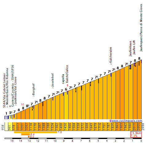
Monte Giovo isn't very steep, but is extremely consistent, with gradients always between 7 and 8,5% throughout 15km. By itself a formidable climb... but dwarfed by the two remaining climbs.
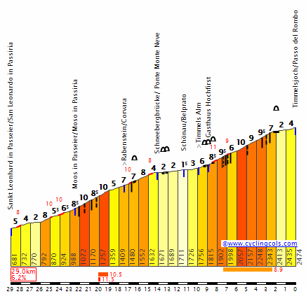
First comes Passo del Rombo, a very long climb with two steep sections with gradients up to 11%, and a false flat section in the middle. By itself it should be more than enough to break apart the peloton.
And yet, the last climb of the stage is even harder.
The climb to Rettenbachferner, most recently used in this year's Tour de Suisse, is extremely hard. Except for a small break halfway through, its slopes rarely go below 10%. The most difficult part comes at the beginning, with 5 kms at almost 12%. The second half features slightly more manageable gradients (around 10% instead of 12%), but with a full km at 13%. With the summit comming at 2650m above sea level, the end of this stage will also be the highest point of the race.
A critical stage for climbers early on the race, that might be devastating for those trying to reach peak form later on the race. Big gaps should form on the summit finish, particularly if someone tries to make a move earlier on the climb. And with a rest day coming up, it's very possible that we'll see some atacks.
Another thing to note is the weather; with two climbs over 2400m and a summit finish well over 2600, a snow-out might be likely. While there are alternative routes in case of snow (head into Austria via Brennerjoch until Innsbruck, then go west through Kühtai, then enter the Sölden valley from the north and climb the first half of Rettenbachferner), the stage would clearly be much less interesting than the original. Hopefully that wouldn't be the case.
(I know the Monte Giovo-Rombo-Rettenbachferner combo has already been done in this thread, but it's just too good to pass up on)
REST DAY: Innsbruck (Austria)
Climbs: Monte Giovo (15,1km @ 7,6%), Passo del Rombo (29km @ 6,2%), Rettenbachferner (11,9km @ 10,8%)
Stage 10 may be a short stage... but it's an extremely hard one. No rest for the final 100km, three very hard cat.1 climbs, and a brutal summit finish at a high altitude.
There are only 50kms of respite early on, before the first of the big climbs.
Monte Giovo isn't very steep, but is extremely consistent, with gradients always between 7 and 8,5% throughout 15km. By itself a formidable climb... but dwarfed by the two remaining climbs.
First comes Passo del Rombo, a very long climb with two steep sections with gradients up to 11%, and a false flat section in the middle. By itself it should be more than enough to break apart the peloton.
And yet, the last climb of the stage is even harder.
The climb to Rettenbachferner, most recently used in this year's Tour de Suisse, is extremely hard. Except for a small break halfway through, its slopes rarely go below 10%. The most difficult part comes at the beginning, with 5 kms at almost 12%. The second half features slightly more manageable gradients (around 10% instead of 12%), but with a full km at 13%. With the summit comming at 2650m above sea level, the end of this stage will also be the highest point of the race.
A critical stage for climbers early on the race, that might be devastating for those trying to reach peak form later on the race. Big gaps should form on the summit finish, particularly if someone tries to make a move earlier on the climb. And with a rest day coming up, it's very possible that we'll see some atacks.
Another thing to note is the weather; with two climbs over 2400m and a summit finish well over 2600, a snow-out might be likely. While there are alternative routes in case of snow (head into Austria via Brennerjoch until Innsbruck, then go west through Kühtai, then enter the Sölden valley from the north and climb the first half of Rettenbachferner), the stage would clearly be much less interesting than the original. Hopefully that wouldn't be the case.
(I know the Monte Giovo-Rombo-Rettenbachferner combo has already been done in this thread, but it's just too good to pass up on)
REST DAY: Innsbruck (Austria)
- Aug 21, 2015
- 380
- 0
- 9,280
Re: Stage 10
Stage 10: Marseille - Auqasplash Antibes 209.3 km


After a nice rest day in Marseille, we are off on the next stage here. Should just be a flat transitional stage for the sprinters although we hang around the coast for a fair amount towards the end in the event the wind wants to make things interesting. There is some pretty nice terrain for a hilly stage in the area and we do get to a couple climbs but I am keeping things flat here as this week is going to be tough enough for the riders.
The finish for the stage will take place at the Aquasplash Water Park just to the north of Antibes. There should be plenty of room for everything and the finish is not far from the beach either so it should be a fun easy day for everyone with a nice sprint finish at the end.
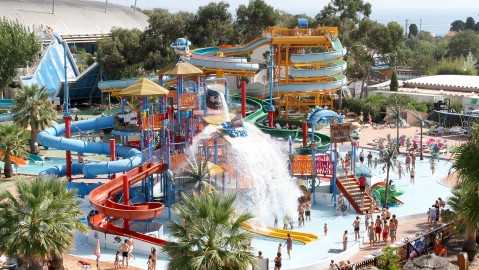
After this stage, the riders have a fairly decent sized transfer over to Menton for the next stage.
Stage 10: Marseille - Auqasplash Antibes 209.3 km
After a nice rest day in Marseille, we are off on the next stage here. Should just be a flat transitional stage for the sprinters although we hang around the coast for a fair amount towards the end in the event the wind wants to make things interesting. There is some pretty nice terrain for a hilly stage in the area and we do get to a couple climbs but I am keeping things flat here as this week is going to be tough enough for the riders.
The finish for the stage will take place at the Aquasplash Water Park just to the north of Antibes. There should be plenty of room for everything and the finish is not far from the beach either so it should be a fun easy day for everyone with a nice sprint finish at the end.
After this stage, the riders have a fairly decent sized transfer over to Menton for the next stage.
- Jun 30, 2014
- 7,060
- 2
- 0
Rettenbachferner on stage 10 nice, a little bit hard but stage 8 and stage 9 are both rather easy, so it shouldn't be a huge problem and bad weather could also be a problem in the 2nd or 3rd week of the Giro, I remember snowstorms on ther Brenner/Brennero in June, July and August, you can always have bad luck in the Alpes.bp92 said:Giro d'Italia Stage 10: Brunico/Bruneck - Rettenbachferner (Austria), 151km (*****)
Climbs: Monte Giovo (15,1km @ 7,6%), Passo del Rombo (29km @ 6,2%), Rettenbachferner (11,9km @ 10,8%)
Stage 10 may be a short stage... but it's an extremely hard one. No rest for the final 100km, three very hard cat.1 climbs, and a brutal summit finish at a high altitude.
There are only 50kms of respite early on, before the first of the big climbs.
Monte Giovo isn't very steep, but is extremely consistent, with gradients always between 7 and 8,5% throughout 15km. By itself a formidable climb... but dwarfed by the two remaining climbs.
First comes Passo del Rombo, a very long climb with two steep sections with gradients up to 11%, and a false flat section in the middle. By itself it should be more than enough to break apart the peloton.
And yet, the last climb of the stage is even harder.
The climb to Rettenbachferner, most recently used in this year's Tour de Suisse, is extremely hard. Except for a small break halfway through, its slopes rarely go below 10%. The most difficult part comes at the beginning, with 5 kms at almost 12%. The second half features slightly more manageable gradients (around 10% instead of 12%), but with a full km at 13%. With the summit comming at 2650m above sea level, the end of this stage will also be the highest point of the race.
A critical stage for climbers early on the race, that might be devastating for those trying to reach peak form later on the race. Big gaps should form on the summit finish, particularly if someone tries to make a move earlier on the climb. And with a rest day coming up, it's very possible that we'll see some atacks.
Another thing to note is the weather; with two climbs over 2400m and a summit finish well over 2600, a snow-out might be likely. While there are alternative routes in case of snow (head into Austria via Brennerjoch until Innsbruck, then go west through Kühtai, then enter the Sölden valley from the north and climb the first half of Rettenbachferner), the stage would clearly be much less interesting than the original. Hopefully that wouldn't be the case.
(I know the Monte Giovo-Rombo-Rettenbachferner combo has already been done in this thread, but it's just too good to pass up
REST DAY: Innsbruck (Austria)
- Oct 4, 2015
- 417
- 1
- 3,030
Giro d'Italia Stage 11: Innsbruck (Austria) - Merano/Meran, 205km (**)


Climbs: Telfs (14,2km @3,2%), Passo di Resia (17,4km @ 3%)
The first stage of the second week takes us back to Italy, with an easy stage between Innsbruck and Merano. There are only two climbs, both shallow and far from the end of the stage, so a sprint is a likely outcome, unless someone tries to make a move in the downhill section near the end of the stage, or the peloton gets careless with a breakaway.
- Oct 4, 2015
- 417
- 1
- 3,030
@Mayomaniac: Well, with so many stages cancelled or almost cancelled due to snow, I just decided to try and make sure there were realistic alternative routes to Rettenbach from Italy. Still, it's a good point that snow can happen at lower altitudes too (they cancelled the alternative Val Martello 2013 stage because Tonale was snowed out, after all).
Giro d'Italia Stage 12: Bressanone/Brixen - Feltre, 238km (****)


Climbs: Natz (4,7km @ 6,6%), Passo Valparola (13,5km @ 5,7%), Passo Pordoi (9,2km @ 6,9%), Passo di San Pellegrino (12km @ 6,2%), Passo di Valles (7,2km @ 8,7%), Passo Rolle (), Passo Croce d'Aune ()
Now comes a big medium mountain stage... in middle of the Dolomites. 238km, with 7 climbs along the way, 5 of them cat.2 climbs.
The climbing starts early on, with the climb to Natz starting up just 2 kms into the stage. After Natz comes an ascending false flat section, which then transitions into the climb to Passo Valparola.
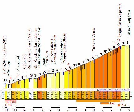
This climb is quickly followed by another classic Dolomites climb, Passo Pordoi (from km 9,2 in the profile below). It's usually climbed from the western side, either to seek a stage finish in Corvara (via Campolongo or Valparola) or as a summit finish itself. This time we climb from the eastern side, however, as we enter the Val di Fassa.
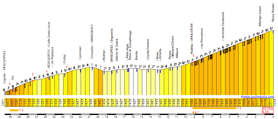
After Pordoi's descent comes a slightly downhill section down the valley, interrupted by the beginning of a very tough three climb chain: San Pellegrino-Valles-Rolle. The first of these climbs is somewhat irregular, with gradients comparable to those of Valparola and Pordoi.
Then, after a short but steep descent, we quickly take on the final 7kms of Passo Valles. A very steep climb, with gradients mostly between 8 and 11%.
The final climb of the trio, Passo Rolle (from km 6,6 in the profile below), is also the easiest, but with the two preceding climbs it should only help break up the peloton even further - if it isn't already wrecked by his point.
A 23km descent through Passo Rolle's southern side comes right after, giving little chance for regroupings. After the end of the descent, an easier 20km downhill/flat section should calm things down a bit... but not for long, as there's still one climb left to go: Passo Croce d'Aune. With over 210kms and six climbs behind, this one should be a test of endurance, particularly with its difficult final 4kms averaging 8%.

The steep descent from Croce d'Aune leaves us only 5kms away from the finish in Feltre.
A very difficult medium mountain stage, which should be almost impossible to control by the teams. A big breakaway may gain a lot of time on the peloton. Some GC riders might end up losing the race here, too. Good descenders will also try to use Rolle and Croce d'Aune to get some time on other contenders.
Giro d'Italia Stage 12: Bressanone/Brixen - Feltre, 238km (****)
Climbs: Natz (4,7km @ 6,6%), Passo Valparola (13,5km @ 5,7%), Passo Pordoi (9,2km @ 6,9%), Passo di San Pellegrino (12km @ 6,2%), Passo di Valles (7,2km @ 8,7%), Passo Rolle (), Passo Croce d'Aune ()
Now comes a big medium mountain stage... in middle of the Dolomites. 238km, with 7 climbs along the way, 5 of them cat.2 climbs.
The climbing starts early on, with the climb to Natz starting up just 2 kms into the stage. After Natz comes an ascending false flat section, which then transitions into the climb to Passo Valparola.
This climb is quickly followed by another classic Dolomites climb, Passo Pordoi (from km 9,2 in the profile below). It's usually climbed from the western side, either to seek a stage finish in Corvara (via Campolongo or Valparola) or as a summit finish itself. This time we climb from the eastern side, however, as we enter the Val di Fassa.
After Pordoi's descent comes a slightly downhill section down the valley, interrupted by the beginning of a very tough three climb chain: San Pellegrino-Valles-Rolle. The first of these climbs is somewhat irregular, with gradients comparable to those of Valparola and Pordoi.
Then, after a short but steep descent, we quickly take on the final 7kms of Passo Valles. A very steep climb, with gradients mostly between 8 and 11%.
The final climb of the trio, Passo Rolle (from km 6,6 in the profile below), is also the easiest, but with the two preceding climbs it should only help break up the peloton even further - if it isn't already wrecked by his point.
A 23km descent through Passo Rolle's southern side comes right after, giving little chance for regroupings. After the end of the descent, an easier 20km downhill/flat section should calm things down a bit... but not for long, as there's still one climb left to go: Passo Croce d'Aune. With over 210kms and six climbs behind, this one should be a test of endurance, particularly with its difficult final 4kms averaging 8%.
The steep descent from Croce d'Aune leaves us only 5kms away from the finish in Feltre.
A very difficult medium mountain stage, which should be almost impossible to control by the teams. A big breakaway may gain a lot of time on the peloton. Some GC riders might end up losing the race here, too. Good descenders will also try to use Rolle and Croce d'Aune to get some time on other contenders.
- Feb 18, 2015
- 13,913
- 10,041
- 28,180
DACH Rundfahrt stage 13: Murau - Bad Kleinkirchheim (210 km)
difficulty: ****


Stage 13 and its the first high mountain stage in Austria. Although there has already been a high mountain stage in the first week, finishing on the Kehlsteinhaus, this is the first real roller coaster stage with one 2nd category, three 1st category and one HC climb. However its only a 4 star stage because the finish just isnt that difficult.
Only shortly after the start in Murau the riders will already climb the first pass of the stage, the Sölkpass. This absolutely scenic pass is maybe already the hardest climb of the day although its only 1st cat. (the last kilometers are extremely steep with 5 km's at 10%, but it only has an altitude difference of about 900 meters and it feels kind of wrong to rate such a climb HC if its average elevation gain is only about 7% steep). That means that the break which will probably form on this ascent, should be very strong. Besides that maybe, just maybe it can also already cause some problems for some domestic's.


After the descent the longest flat section of the stage follows with an intermediate sprint in the famous skiing area Schladming as the only highlight. I could have used the climb to Ramsau here, but I think the stage is already difficult enough as it is.
The next climb is the Radstädter Tauernpass, with the town Obertauern at the top. I think this is the only climb of the stage which has already been used in a bike race in the near future, which was the queen stage of the Österreich Rundfahrt 2014. However it was the first climb of that stage so there was neither any action on the climb nor TV coverage. The climb is just a classic 1st category climb, not extremely steep, not extremely long, but the combination still makes it difficult.

Again there is a short flat section after the descent, although this part is rather a false downhill section. But this time the next climb is IMO clearly more difficult. Well, the Katschberghöhe is only 5 kilometers long, but the gradients are MURDERKILLERDEATH gradients. I don't know if you can read it on the profile below but yes the last kilometer is 14.5% steep and, yes there is another 1.5 km long section at 13.3% but hey the flattest kilometer is not even 10 but 9.9% steep. Brutality at its finest and if a rider has a bad day and the pace is high, there doesnt even have to be an attack so the rider will drop.

Unfortunately there is another false downhill after the descent which will make it less likely that a team will already set a very high pace on the Katschberghöhe, but at least the next climb won't be easier. The riders arrive on the Nockalmstraße, a street which consists of two climbs, the Eisenthalhöhe, followed by the real top of the Nockalmstraße. Actually the street is only called like that for the last 8k's of the first climb (the part you can see on the "quäl dich" profile), but the first half isnt any flatter. A the end the ascent maybe doesnt have such super steep gradients like the Katschberghöhe, but its a very long climb and after the hard climbs the riders already passed today the length of the pass will hurt even more and some of the favorites might start to fade.
However directly after the short descent the second of the two Nockalmstraßen ascents starts, which maybe is much shorter but steeper. The next two stages are also mountain stages and the riders are still pretty far away from the finish so I wouldnt expect many riders to attack (although very special race situations just sometimes happen and sometimes cycling is just completely unpredictable), but considering how much the riders have already climbed and how small the group of the favorites probably is at that point, its not that unlikely that a favorite has troubles to stay in the front group, and then the pace wouldnt drop anymore and the stage could suddenly become extremely interesting.


After a technical descent and a little bump only 5 k's before the finish, the riders arrive in Bad Kleinkirchheim a city which is (surprise, surprise) most famous for Alpine Skiing. It also sometimes hosts World Cup Skiing races in all diciplines. The women normally use the Franz Klammer slope for downhill races and Super-G's while the men have only visited the town once in the last few years, which was in 2007, when Benjamin Raich won the last Slalom of his career.

difficulty: ****
Stage 13 and its the first high mountain stage in Austria. Although there has already been a high mountain stage in the first week, finishing on the Kehlsteinhaus, this is the first real roller coaster stage with one 2nd category, three 1st category and one HC climb. However its only a 4 star stage because the finish just isnt that difficult.
Only shortly after the start in Murau the riders will already climb the first pass of the stage, the Sölkpass. This absolutely scenic pass is maybe already the hardest climb of the day although its only 1st cat. (the last kilometers are extremely steep with 5 km's at 10%, but it only has an altitude difference of about 900 meters and it feels kind of wrong to rate such a climb HC if its average elevation gain is only about 7% steep). That means that the break which will probably form on this ascent, should be very strong. Besides that maybe, just maybe it can also already cause some problems for some domestic's.
After the descent the longest flat section of the stage follows with an intermediate sprint in the famous skiing area Schladming as the only highlight. I could have used the climb to Ramsau here, but I think the stage is already difficult enough as it is.
The next climb is the Radstädter Tauernpass, with the town Obertauern at the top. I think this is the only climb of the stage which has already been used in a bike race in the near future, which was the queen stage of the Österreich Rundfahrt 2014. However it was the first climb of that stage so there was neither any action on the climb nor TV coverage. The climb is just a classic 1st category climb, not extremely steep, not extremely long, but the combination still makes it difficult.
Again there is a short flat section after the descent, although this part is rather a false downhill section. But this time the next climb is IMO clearly more difficult. Well, the Katschberghöhe is only 5 kilometers long, but the gradients are MURDERKILLERDEATH gradients. I don't know if you can read it on the profile below but yes the last kilometer is 14.5% steep and, yes there is another 1.5 km long section at 13.3% but hey the flattest kilometer is not even 10 but 9.9% steep. Brutality at its finest and if a rider has a bad day and the pace is high, there doesnt even have to be an attack so the rider will drop.
Unfortunately there is another false downhill after the descent which will make it less likely that a team will already set a very high pace on the Katschberghöhe, but at least the next climb won't be easier. The riders arrive on the Nockalmstraße, a street which consists of two climbs, the Eisenthalhöhe, followed by the real top of the Nockalmstraße. Actually the street is only called like that for the last 8k's of the first climb (the part you can see on the "quäl dich" profile), but the first half isnt any flatter. A the end the ascent maybe doesnt have such super steep gradients like the Katschberghöhe, but its a very long climb and after the hard climbs the riders already passed today the length of the pass will hurt even more and some of the favorites might start to fade.
However directly after the short descent the second of the two Nockalmstraßen ascents starts, which maybe is much shorter but steeper. The next two stages are also mountain stages and the riders are still pretty far away from the finish so I wouldnt expect many riders to attack (although very special race situations just sometimes happen and sometimes cycling is just completely unpredictable), but considering how much the riders have already climbed and how small the group of the favorites probably is at that point, its not that unlikely that a favorite has troubles to stay in the front group, and then the pace wouldnt drop anymore and the stage could suddenly become extremely interesting.
After a technical descent and a little bump only 5 k's before the finish, the riders arrive in Bad Kleinkirchheim a city which is (surprise, surprise) most famous for Alpine Skiing. It also sometimes hosts World Cup Skiing races in all diciplines. The women normally use the Franz Klammer slope for downhill races and Super-G's while the men have only visited the town once in the last few years, which was in 2007, when Benjamin Raich won the last Slalom of his career.
- Feb 20, 2010
- 33,248
- 15,774
- 28,180
The biggest problem with that DACH Rundfahrt stage is simply that the TV cameras probably won't have turned on early enough to give us Sölkpass helicam footage.
- Feb 18, 2015
- 13,913
- 10,041
- 28,180
Re:

yes, thats a pityLibertine Seguros said:The biggest problem with that DACH Rundfahrt stage is simply that the TV cameras probably won't have turned on early enough to give us Sölkpass helicam footage.
- Oct 27, 2015
- 86
- 0
- 0
Re:
Well, the TdF usually has one (perhaps two ?) stages each year with a full coverage. Why not DACH Rundfahrt ?
Anyway I think that the 50 km flat after Sölkpass would mainly make it a fight for the break with no GC action - not that this would be uninteresting.
A hell of a good stage anyway
Libertine Seguros said:The biggest problem with that DACH Rundfahrt stage is simply that the TV cameras probably won't have turned on early enough to give us Sölkpass helicam footage.
Well, the TdF usually has one (perhaps two ?) stages each year with a full coverage. Why not DACH Rundfahrt ?
Anyway I think that the 50 km flat after Sölkpass would mainly make it a fight for the break with no GC action - not that this would be uninteresting.
A hell of a good stage anyway
- Aug 21, 2015
- 380
- 0
- 9,280
Re: Stage 11
Stage 11: Menton - Sospel 165.9 km


Okay it is time for my favorite stage in the entire route. Yeah, I know it comes on a Wednesday but we can just pretend that Bastille day falls on a Wednesday for the year of this route.
We start this route right off with a bang as we start climbing the Col de la Madone about 1 km into the stage. Now the Col de la Madone is a fairly famous climb known in large part due to being a favorite of Lance Armstrong. It would be one of his training climbs before the tour although Tony Rominger is credited as being the first famous rider to use it as a training climb. It is a very technical climb as are all the roads on this stage and it is very easy to lose sight of an attacker on the climb due to there being so many turns. This makes it perfect to start off this stage as it will feature right when the break wants to establish itself and it should be total chaos as the leading team tries to keep everything under control. I wouldn't be surprised if a struggling GC rider makes a go for it to try to take advantage, a lot of different things can happen.
As famous as the Col de la Madone is, it has not appeared in the Tour de France which is a pity as it is a really nice climb with some great scenery(scenery being another theme of this stage). The descent should be technical as well and should be entertaining to watch, especially if the break is not yet established.
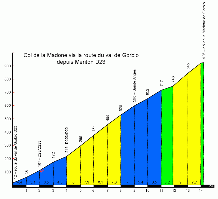
Here is the profile
After about 8 km of false flat to L'Escarene, we start our second climb, the col L'Able. The route up this climb essentially follows the route up to the Col de Braus with the exception that just before we reach the top, we turn to the left and climb for 3-4 more km. The scenery for the climb is exceptional and features this stunning sequence of switchbacks.
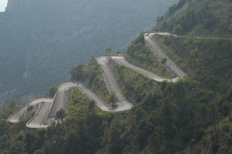
After this climb, we descend for about 4 km before joining the road to the Baisse de la Cabanette featuring some more stunning switchbacks and scenery. After this climb, we get a fairly long technical descent to Contes and the feed zone.
Once we are finally at the bottom, we start right back climbing up the Cote de Vallee along the D 615 before descending and taking on the Col de Nice up to the first Sprint point in L'Escarene. I decided to throw in 2 sprint points for this stage as the bonus seconds from both could encourage earlier attacks and it wasn't like any sprinters were going to be able to get points from them. After the sprint, we have a long drag up the Col de la Porte before descending and hitting the second sprint point. That is when things get interesting, even if the stage has been soft pedaled much to my annoyance.
This stage will now essentially become the classic Monte Carlo Rally route for the Col du Turini as we climb from La - Bollene - Vesubie to the top col the Col du Turini and then have a downhill finish in Sospel. Libertine came very close to guessing it, couldn't come up with a good way to respond without giving it away The climb itself is HC and should be a nice battleground for the GC men all the way up. It is a fairly consistent climb averaging between 7 and 9 percent most of the way up. It is a very technical climb as well obviously and the scenery is spectacular like the other climbs.
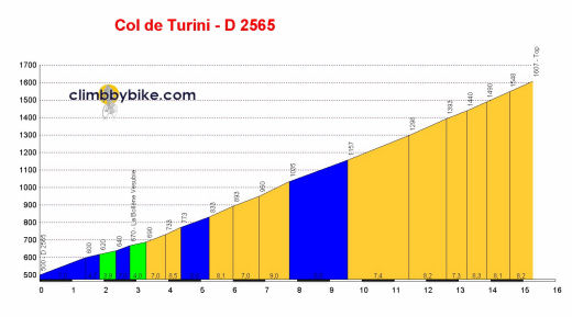
Profile
The main attraction of this stage however is the descent as of course it is very technical. The Tour has been looking for a good downhill finish location for a while now with their expeditions over the Manse among other areas. They really should give this climb a look as an area to hit. They would have to get Sospel or another town at the bottom to host the finish but there are areas in the Alps or Pyrenees that are similar sized and are able to. Sospel has also hosted Monte Carlo Rally Stage finishes before as well so I do not see how it would be a huge stretch for them to host a TDF finish. Sospel is pretty close to Menton, Nice, and Monaco so there are plenty of areas for the riders to stay. Also there is a lot of opportunity for other exciting stages in the area. Sales pitch aside, it is an area that could work very well for the Tour.
Back to our downhill finish, it should be a very entertaining finale with the good possibility that a more well rounded rider like Nibali could attack on the climb and gain some serious time in the twisty descent. The scenery is beautiful as well of course. The roads are also in good condition and if any of the riders complain, all one needs to do is let them know about the famous rally stages and how it used to be ran during the night(as fun as that would be for us, I don't know if the TV stations would be on board as it would be a bit hard to keep track of the riders). Overall it should be a very fun day for us viewers, maybe not so much for some of the riders.
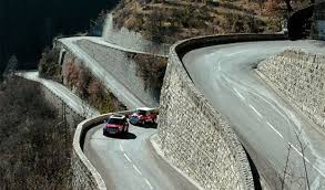
A lot of hairpins to account for on the way down.
After the stage, the riders will transfer back over to Nice for some more climbing tomorrow.
Stage 11: Menton - Sospel 165.9 km
Okay it is time for my favorite stage in the entire route. Yeah, I know it comes on a Wednesday but we can just pretend that Bastille day falls on a Wednesday for the year of this route.
We start this route right off with a bang as we start climbing the Col de la Madone about 1 km into the stage. Now the Col de la Madone is a fairly famous climb known in large part due to being a favorite of Lance Armstrong. It would be one of his training climbs before the tour although Tony Rominger is credited as being the first famous rider to use it as a training climb. It is a very technical climb as are all the roads on this stage and it is very easy to lose sight of an attacker on the climb due to there being so many turns. This makes it perfect to start off this stage as it will feature right when the break wants to establish itself and it should be total chaos as the leading team tries to keep everything under control. I wouldn't be surprised if a struggling GC rider makes a go for it to try to take advantage, a lot of different things can happen.
As famous as the Col de la Madone is, it has not appeared in the Tour de France which is a pity as it is a really nice climb with some great scenery(scenery being another theme of this stage). The descent should be technical as well and should be entertaining to watch, especially if the break is not yet established.
Here is the profile
After about 8 km of false flat to L'Escarene, we start our second climb, the col L'Able. The route up this climb essentially follows the route up to the Col de Braus with the exception that just before we reach the top, we turn to the left and climb for 3-4 more km. The scenery for the climb is exceptional and features this stunning sequence of switchbacks.
After this climb, we descend for about 4 km before joining the road to the Baisse de la Cabanette featuring some more stunning switchbacks and scenery. After this climb, we get a fairly long technical descent to Contes and the feed zone.
Once we are finally at the bottom, we start right back climbing up the Cote de Vallee along the D 615 before descending and taking on the Col de Nice up to the first Sprint point in L'Escarene. I decided to throw in 2 sprint points for this stage as the bonus seconds from both could encourage earlier attacks and it wasn't like any sprinters were going to be able to get points from them. After the sprint, we have a long drag up the Col de la Porte before descending and hitting the second sprint point. That is when things get interesting, even if the stage has been soft pedaled much to my annoyance.
This stage will now essentially become the classic Monte Carlo Rally route for the Col du Turini as we climb from La - Bollene - Vesubie to the top col the Col du Turini and then have a downhill finish in Sospel. Libertine came very close to guessing it, couldn't come up with a good way to respond without giving it away
The climb itself is HC and should be a nice battleground for the GC men all the way up. It is a fairly consistent climb averaging between 7 and 9 percent most of the way up. It is a very technical climb as well obviously and the scenery is spectacular like the other climbs.
Profile
The main attraction of this stage however is the descent as of course it is very technical. The Tour has been looking for a good downhill finish location for a while now with their expeditions over the Manse among other areas. They really should give this climb a look as an area to hit. They would have to get Sospel or another town at the bottom to host the finish but there are areas in the Alps or Pyrenees that are similar sized and are able to. Sospel has also hosted Monte Carlo Rally Stage finishes before as well so I do not see how it would be a huge stretch for them to host a TDF finish. Sospel is pretty close to Menton, Nice, and Monaco so there are plenty of areas for the riders to stay. Also there is a lot of opportunity for other exciting stages in the area. Sales pitch aside, it is an area that could work very well for the Tour.
Back to our downhill finish, it should be a very entertaining finale with the good possibility that a more well rounded rider like Nibali could attack on the climb and gain some serious time in the twisty descent. The scenery is beautiful as well of course. The roads are also in good condition and if any of the riders complain, all one needs to do is let them know about the famous rally stages and how it used to be ran during the night(as fun as that would be for us, I don't know if the TV stations would be on board as it would be a bit hard to keep track of the riders). Overall it should be a very fun day for us viewers, maybe not so much for some of the riders.
A lot of hairpins to account for on the way down.
After the stage, the riders will transfer back over to Nice for some more climbing tomorrow.
- Jul 26, 2015
- 145
- 0
- 0
I think i wouldnt be able to design a correct stage in Austria.
It would take just too much time for me to settle on something with that many horrible options...
That final trilogy in Stage 12, though, thats just good. And thats coming in the same tour as the Kehlsteinhaus.
-Brillant stage in the Alpes-Maritimes, Andrew.
Underused region of course, as its really far from the main routes.
The Madone as the first climb, thats a strong choice. Its narrow, but the race will be already on right away.
The Millau stage was very solid as well, the Cévennes are always a good choice anyway.
-I shoud also say that i liked the Vic-Berga stage as well as the basque stage of the LS' Vuelta, and i found very interesting the Brixen-Feltre stage of bp92.
- Oct 4, 2015
- 417
- 1
- 3,030
Nice stages in Austria and France.
It's unfortunate that Sölkapass is so far away from goal, where it won't be anywhere near decisive enough, but the actual defining climbs are good enough anyway.
The Turini stage also looks great. Turini's incredibly underused, given its Montecarlo rally history (and the fact that it's an incredibly beautiful road on its own).
Giro d'Italia Stage 13: Feltre - Gardaland (Castelnuovo del Garda), 175km (*)


Climbs: Sella di Roa (7km @ 6,5%), Vigolo Vattaro (2,8km @ 7,4%)
After the Dolomites we have a flat sprint stage, finishing in the medieval-theme park of Gardaland, next to the Lago di Garda, with the last 50 kms going along the lake's eastern shore, in what should be a very scenic ending. Racing-wise this stage isn't particularly interesting, however, serving as a break between the big Feltre medium mountains and the second weekend mountain stages.
It's unfortunate that Sölkapass is so far away from goal, where it won't be anywhere near decisive enough, but the actual defining climbs are good enough anyway.
The Turini stage also looks great. Turini's incredibly underused, given its Montecarlo rally history (and the fact that it's an incredibly beautiful road on its own).
Giro d'Italia Stage 13: Feltre - Gardaland (Castelnuovo del Garda), 175km (*)
Climbs: Sella di Roa (7km @ 6,5%), Vigolo Vattaro (2,8km @ 7,4%)
After the Dolomites we have a flat sprint stage, finishing in the medieval-theme park of Gardaland, next to the Lago di Garda, with the last 50 kms going along the lake's eastern shore, in what should be a very scenic ending. Racing-wise this stage isn't particularly interesting, however, serving as a break between the big Feltre medium mountains and the second weekend mountain stages.
- Oct 4, 2015
- 417
- 1
- 3,030
Giro d'Italia Stage 14: Verona - Marilleva 1400, 197km (***)


Climbs: Cadine (4.9km @ 5,8%), Passo Durone (10.2km @ 6,2%), Campo Carlo Magno (14,6km @ 5,9%), Marilleva (7,2km @ 9,3%)
Stage 14 takes us back into the Alps for another summit finish stage, this time at Marileva 1400.
As with several previous stages, this one features a flat first half, until we reach Trento and head up the short ascent to Cadine. Then, after some rolling terrain, we reach the foot of the second climb, Passo Durone.
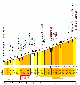
After a 20km false flat section, we reach the deciding part of the stage, featuring first the climb to Campo Carlo Magno, a continuation of the typical ascent up the southern side of Madonna di Campiglio, heading through the ski resort before completing the ascent (the last 4km are slightly different, with a flatter section through Campiglio).
Afterwards, there's only one last climb left to go, the summit finish cimb to Marilleva 1400. The stage's finishing line isn't in the ski resort itself (it's located further ahead, after a short descent), but at the highest point of the road heading into the station.

The climb is short but very steep, with full kms over 11% intercalated with more manageable sections around 8%. Good climbers might be able to get some more time here, particularly if the pace is high through Carlo Magno. However, some riders will want to save energy for what comes tomorrow...
Climbs: Cadine (4.9km @ 5,8%), Passo Durone (10.2km @ 6,2%), Campo Carlo Magno (14,6km @ 5,9%), Marilleva (7,2km @ 9,3%)
Stage 14 takes us back into the Alps for another summit finish stage, this time at Marileva 1400.
As with several previous stages, this one features a flat first half, until we reach Trento and head up the short ascent to Cadine. Then, after some rolling terrain, we reach the foot of the second climb, Passo Durone.
After a 20km false flat section, we reach the deciding part of the stage, featuring first the climb to Campo Carlo Magno, a continuation of the typical ascent up the southern side of Madonna di Campiglio, heading through the ski resort before completing the ascent (the last 4km are slightly different, with a flatter section through Campiglio).
Afterwards, there's only one last climb left to go, the summit finish cimb to Marilleva 1400. The stage's finishing line isn't in the ski resort itself (it's located further ahead, after a short descent), but at the highest point of the road heading into the station.
The climb is short but very steep, with full kms over 11% intercalated with more manageable sections around 8%. Good climbers might be able to get some more time here, particularly if the pace is high through Carlo Magno. However, some riders will want to save energy for what comes tomorrow...
- Sep 28, 2014
- 3,639
- 1,608
- 16,680
Gigs: As usual, Austria brings up some really good climbs, but some beautiful scenery. Shame the Osterreich Rundfarht isnt televised to the world.
Andrew: I really like that stage. The Alpes Maritimes has some really good terrain to be used. It has had some great racing through it, during the Paris Nice. Shame it isnt used in Le Tour more.
Andrew: I really like that stage. The Alpes Maritimes has some really good terrain to be used. It has had some great racing through it, during the Paris Nice. Shame it isnt used in Le Tour more.
- Oct 4, 2015
- 417
- 1
- 3,030
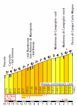
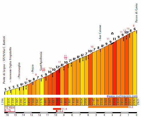
Giro d'Italia Stage 15: Mezzolombardo - Tirano, 222km (*****)


Climbs: Passo del Tonale (15,2km @ 6%), Passo di Gavia (16,3km @ 8%), Passo del Mortirolo (12,1km @ 10,7%), Monte Padrio (17km @ 6,9%).
Now comes the queen stage of the race. And, since I've admittedly gotten a bit carried away with the summit finishes, this one actually finishes downhill, in Tirano.
And, with three very difficult cat.1 climbs along the way, this one's going to be hard.
The stage starts in Mezzolombardo, then quickly heads towards the Val di Sole, where the previous stage finished. Riders will then get out of this valley via a well-known climb, Passo del Tonale.
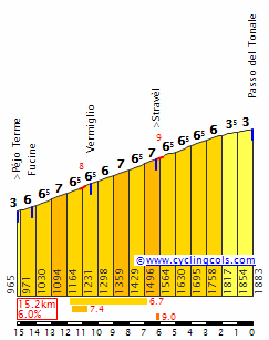
Right after Tonale we take on one of the Giro's old classics: Passo di Gavia, the second highest climb of the race at 2621m above sea level. It comes early on in the stage, but it should hurt a lot.
Then, after Gavia's very long descent, comes one of Italy's most (in)famous climbs: Passo del Mortirolo. It barely needs any introduction; suffice to say, its brutal middle slopes should be more than enough to blow the peloton apart, particularly if the pace through Tonale/Gavia is high.
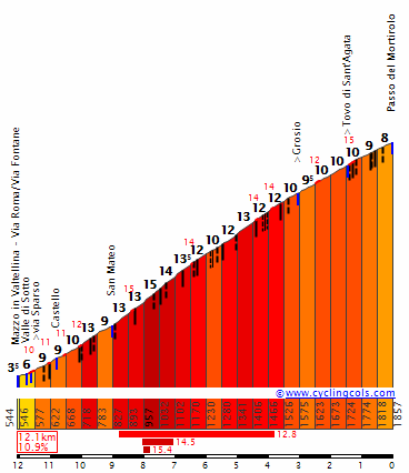
However, there's still some more climbing left. The next climb isn't as hard as Mortirolo... but, with Mortirolo still fresh on the legs, and after 180km of racing, it should hurt a lot.
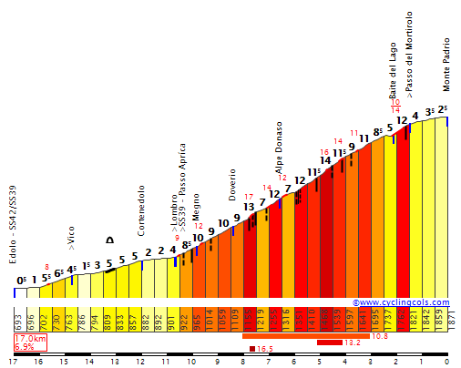
Monte Padrio is another climb that has never been used in the Giro. With a hardest section featuring 7km around 10%, and a full km well over 13%, it's a very hard climb too. Attacks may not even be necessary here; the wear from Mortirolo and this climb should be enough to create huge gaps between the contenders. Descenders get another big chance with the downhill finish, too.
REST DAY: Tirano
Climbs: Passo del Tonale (15,2km @ 6%), Passo di Gavia (16,3km @ 8%), Passo del Mortirolo (12,1km @ 10,7%), Monte Padrio (17km @ 6,9%).
Now comes the queen stage of the race. And, since I've admittedly gotten a bit carried away with the summit finishes, this one actually finishes downhill, in Tirano.
And, with three very difficult cat.1 climbs along the way, this one's going to be hard.
The stage starts in Mezzolombardo, then quickly heads towards the Val di Sole, where the previous stage finished. Riders will then get out of this valley via a well-known climb, Passo del Tonale.
Right after Tonale we take on one of the Giro's old classics: Passo di Gavia, the second highest climb of the race at 2621m above sea level. It comes early on in the stage, but it should hurt a lot.
Then, after Gavia's very long descent, comes one of Italy's most (in)famous climbs: Passo del Mortirolo. It barely needs any introduction; suffice to say, its brutal middle slopes should be more than enough to blow the peloton apart, particularly if the pace through Tonale/Gavia is high.
However, there's still some more climbing left. The next climb isn't as hard as Mortirolo... but, with Mortirolo still fresh on the legs, and after 180km of racing, it should hurt a lot.
Monte Padrio is another climb that has never been used in the Giro. With a hardest section featuring 7km around 10%, and a full km well over 13%, it's a very hard climb too. Attacks may not even be necessary here; the wear from Mortirolo and this climb should be enough to create huge gaps between the contenders. Descenders get another big chance with the downhill finish, too.
REST DAY: Tirano
- Aug 21, 2015
- 380
- 0
- 9,280
Re:
Thanks everyone, I will be attacking the Col de la Madone starting on the D 23 where the roads are a bit wider so hopefully by the time we get to the more narrow roads, things will have sorted themselves enough that it shouldn't be a problem. The Tour really should hit the the Turini and the Alpes Maritimes more though. Even if the area isn't developed enough, there are a lot of different options to cut through or loop back towards the coast.
jsem94 said:I'm salivating.
Steven Roots said:-Brillant stage in the Alpes-Maritimes, Andrew.
Underused region of course, as its really far from the main routes.
The Madone as the first climb, thats a strong choice. Its narrow, but the race will be already on right away.
The Millau stage was very solid as well, the Cévennes are always a good choice anyway.
bp92 said:Nice stages in Austria and France.
It's unfortunate that Sölkapass is so far away from goal, where it won't be anywhere near decisive enough, but the actual defining climbs are good enough anyway.
The Turini stage also looks great. Turini's incredibly underused, given its Montecarlo rally history (and the fact that it's an incredibly beautiful road on its own).
lemon cheese cake said:Andrew: I really like that stage. The Alpes Maritimes has some really good terrain to be used. It has had some great racing through it, during the Paris Nice. Shame it isnt used in Le Tour more.
Thanks everyone, I will be attacking the Col de la Madone starting on the D 23 where the roads are a bit wider so hopefully by the time we get to the more narrow roads, things will have sorted themselves enough that it shouldn't be a problem. The Tour really should hit the the Turini and the Alpes Maritimes more though. Even if the area isn't developed enough, there are a lot of different options to cut through or loop back towards the coast.
- Feb 18, 2015
- 13,913
- 10,041
- 28,180
DACH Rundfahrt stage 14: Spittal an der Drau - Prägraten (206 km)
difficulty: ****


First of all, I just made this stage, its completely new and my original plan was completely different. Just a few minutes ago the stage finish was on the Kitzbüheler Horn, but then I decided that although the Austrian press would go crazy about it, it just would harm the racing on the stage before too much. So I use a combo which I was thinking about for quite some time and which should be pretty good for this purpose.
The start of the stage is in Spittal an der Drau, probably most famous for the Schloss Porcia, one of Austrias most famous renaissance buildings.

The first about 80 kilometers are very flat. The riders also don't pass any famous towns so this first part of the stage is rather uninteresting. However that changes drastically when the riders arrive in Heiligenblut, where the Großglockner Hochalpenstraße starts. That means the riders face the most difficult climb of the whole race so far, maybe even the most difficult climb of the whole tour. There is maybe a short flat section in the middle of the climb and the other side of the pass is even more difficult, but considering what kind of monster the northern side is, that doesnt anything about the southern side, because its still brutal.

As you see, the climb is long, steep, irregular, on high altitude and besides that it is extremely scenic, and also a legendary climb. Its used in the Österreich Rundfahrt about every year and also has some appearances in the giro, like in 2011 when Contador closed the fight for the gc the day before the fight for the gc was supposed to really start. Before I forget to mention it, this is the highest point of the whole Dachrundfahrt, which means no Rettenbachferner, because that on stage 15 would have harmed the route even more than the Kitzbüheler Horn on stage 14. The descent is a very technical one, but the riders are still far away from the finish so I doubt anyone will attack.

Next up is a long flat section which will unfortunately kill any action on the Großglockner (but that would have happened too if I had used the Kitzbüheler Horn and generally you almost have to use a mtf on the Großglockner itself, if you want to have action there).
However about 50 kilometers before the finish the stage gets serious again with the start of the Felbertauern Pass. Although I rated this pass 1st category it is rather flat. But the length of the stage should really make the peloton smaller and maybe even give some riders the chance to attack, although the flat section on the top of the climb (which is inside a tunnel) really is a pity which might kill the action on the ascent.

However the action isnt over yet because directly after the descent the last climb of the stage starts which should be very interesting to watch. The ascent to Virgen also has already been used several times in the Österreich Rundfahrt and it definitely is a good way to finish a stage. There are still a few kilometers left after the end of the climb, so it isnt really a Purito finish, but I think that if the peloton is already small, attacks are still very likely to happen.

As you can see this stage is way less gc relevant than a stage to the Kitzbüheler Horn would have been. However that also means that yesterday's stage suddenly becomes more important because the riders don't have to fear, to loose much time today if they go all out. Its the "easy" stage between the two monster stages, but still a very hard stage on which a gc contender who has already lost a lot of time could still go all in, and try to take back some time. Besides that I agree that the stage still isnt such a great one, but I wanted to use the Großglockner without without using a super hard mtf and this easy uphill finish seemed to be the best thing I could do.
difficulty: ****
First of all, I just made this stage, its completely new and my original plan was completely different. Just a few minutes ago the stage finish was on the Kitzbüheler Horn, but then I decided that although the Austrian press would go crazy about it, it just would harm the racing on the stage before too much. So I use a combo which I was thinking about for quite some time and which should be pretty good for this purpose.
The start of the stage is in Spittal an der Drau, probably most famous for the Schloss Porcia, one of Austrias most famous renaissance buildings.
The first about 80 kilometers are very flat. The riders also don't pass any famous towns so this first part of the stage is rather uninteresting. However that changes drastically when the riders arrive in Heiligenblut, where the Großglockner Hochalpenstraße starts. That means the riders face the most difficult climb of the whole race so far, maybe even the most difficult climb of the whole tour. There is maybe a short flat section in the middle of the climb and the other side of the pass is even more difficult, but considering what kind of monster the northern side is, that doesnt anything about the southern side, because its still brutal.
As you see, the climb is long, steep, irregular, on high altitude and besides that it is extremely scenic, and also a legendary climb. Its used in the Österreich Rundfahrt about every year and also has some appearances in the giro, like in 2011 when Contador closed the fight for the gc the day before the fight for the gc was supposed to really start. Before I forget to mention it, this is the highest point of the whole Dachrundfahrt, which means no Rettenbachferner, because that on stage 15 would have harmed the route even more than the Kitzbüheler Horn on stage 14. The descent is a very technical one, but the riders are still far away from the finish so I doubt anyone will attack.
Next up is a long flat section which will unfortunately kill any action on the Großglockner (but that would have happened too if I had used the Kitzbüheler Horn and generally you almost have to use a mtf on the Großglockner itself, if you want to have action there).
However about 50 kilometers before the finish the stage gets serious again with the start of the Felbertauern Pass. Although I rated this pass 1st category it is rather flat. But the length of the stage should really make the peloton smaller and maybe even give some riders the chance to attack, although the flat section on the top of the climb (which is inside a tunnel) really is a pity which might kill the action on the ascent.
However the action isnt over yet because directly after the descent the last climb of the stage starts which should be very interesting to watch. The ascent to Virgen also has already been used several times in the Österreich Rundfahrt and it definitely is a good way to finish a stage. There are still a few kilometers left after the end of the climb, so it isnt really a Purito finish, but I think that if the peloton is already small, attacks are still very likely to happen.
As you can see this stage is way less gc relevant than a stage to the Kitzbüheler Horn would have been. However that also means that yesterday's stage suddenly becomes more important because the riders don't have to fear, to loose much time today if they go all out. Its the "easy" stage between the two monster stages, but still a very hard stage on which a gc contender who has already lost a lot of time could still go all in, and try to take back some time. Besides that I agree that the stage still isnt such a great one, but I wanted to use the Großglockner without without using a super hard mtf and this easy uphill finish seemed to be the best thing I could do.
TRENDING THREADS
-
 Paris-Roubaix 2026, one day monument, April 12
- Started by Lequack
- Replies: 2K
-
 Itzulia Basque Country 2026, April 6-11
- Started by Dazed and Confused
- Replies: 2K
-

-
 Ronde van Vlaanderen 2026, monument, April 5 (men's)
- Started by Krzysztof_O
- Replies: 1K
-

-

-
 Teams & Riders The Remco Evenepoel is the next Eddy Merckx thread
- Started by DNP-Old
- Replies: 39K


Cyclingnews is part of Future plc, an international media group and leading digital publisher. Visit our corporate site.
© Future Publishing Limited Quay House, The Ambury, Bath BA1 1UA. All rights reserved. England and Wales company registration number 2008885.