• The Cycling News forum is looking to add some volunteer moderators with Red Rick's recent retirement. If you're interested in helping keep our discussions on track, send a direct message to @SHaines here on the forum, or use the Contact Us form to message the Community Team.

    In the meanwhile, please use the Report option if you see a post that doesn't fit within the forum rules.

    Thanks!

Race Design Thread

Page 182 - Get up to date with the latest news, scores & standings from the Cycling News Community.
Everybody seems to be posting interesting stages. Which means that I... won't.

Stage 13: Reinosa - León, 172km

24oc0ed.png


2jecyeu.png


GPM:
Alto del Bardal (cat.3) 4,0km @ 5,7%

p1114124.jpg


Despite the scenic winter snow in the image above, we will be setting off in the heart of summer. This is one of those classic boring stages, which is why unlike the route planners for the Tour de France I've taken care to make sure it happens on a goddamn weekday!!! We start in the small city of Reinosa, the biggest town in southern Cantabria, a short drive over the gradual rise of the Puerto de la Palombera from yesterday's finish. The climb featured in my very first Vuelta route, on the way to a mountaintop finish at Fuente del Chivo, but Reinosa's real Vuelta heritage is much greater as the host of several stage finishes of early mountain stages (inasmuch as the Vuelta did them back then) in the 50s and 60s featuring the Puerto del Escudo, with a final 30k or so flat into Reinosa. The city is also known as the closest sizable urban centre to the source of the Ebro and its proximity to the large reservoir that is the Embalse de Ebro.

1199566722.jpg


The stage features its only real defining feature, the climb of the Alto del Bardal, almost immediately. It's hardly a serious threat but its presence right at the start of the stage might at least mean a decent strength breakaway to keep the chasers in the sprint train honest. After that, however, it's pure rolling plains on the Castilian plateau, passing through a handful of scenic towns as we cross the southern tip of the Sierra de Cantabria, such as Cervera de Pisuerga with its stunning views of the Embalse de Ruesga.

Embalse_de_Ruesga_pisuerga.jpg


After a while, however, it's time to leave the foothills and head full on into the flat lands, as we head towards León, which hosts the closing sprint. León is a regular host of both fantasy and real-life Vueltas; its history within the sport (the Vuelta a León is one of the most important amateur and semi-pro stage races in Spain) and its strategic location (it's the closest major city between the plains and the mountains of northern Asturias, southeastern Galicia and the climbs around Ponferrada, which makes it an excellent start town for a stage into any of the three, as well as being a convenient place to start a flat or hilly stage following a mountainous stage finishing somewhere smaller than your average urban centre) make it a very useful city to route designers. So here we are: a sprint in León. Tomorrow, back to the mountains.

784764_1.jpg
 
Fear not, however, that I am going soft. It's time for the 2nd leg of my "cat.2 and 3 monster stage" trilogy that serves as a centrepiece to this race. Pamplona-Bilbao was the first leg of it, and this is the second. The third comes later, obviously.

Stage 14: León - Oviedo, 185km

2a7c17k.png


2qk1k3p.png


GPM:
Alto de La Cobertoria (cat.1) 9,9km @ 8,8%
Cruz de Linares (cat.1) 7,1km @ 9,0%
Alto del Campo Dosango (cat.2) 6,0km @ 7,7%
Alto de La Collá (cat.3) 2,1km @ 11,9%
Alto de Picullanza (cat.3) 2,5km @ 8,7%
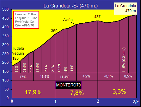
Alto de La Grandota (cat.2) 2,9km @ 10,1%

So, does the format of this stage look familiar? It is basically an amped up version of the Bilbao stage, starting on the plateau, descending into the mountainous province, opening with a tough and iconic climb with its steepest gradients in the middle, then leading into a sequence of small but brutal ascents late on before finishing in a major urban centre for the region. But here, the characteristics of the climbs are slightly different. As a piece of course design I prefer the Basque stage, but that's mainly because a) I'm a huge mark for the Basque Country and am more familiar with the variety of climbs on offer there, and b) the closeness of the short climbs near the end allows a really brutal chain of climbs. Here, the climbs are slightly longer on average, but that does mean that they are more spread out. Also, the stage is over 20km shorter. However, with a relatively well-rested péloton after the expected stage for the break in Cantabria and yesterday's sprint, they should be ready to make this one chaos as the penultimate weekend begins.

The first part of the stage, of course, is utterly flat; the plateau in León is higher, so the mountains it descends into are bigger too. However, easing the riders into the stage does mean that we may be left with a comparatively unusual breakaway for such a stage, however I would expect GPM contenders to want to be in this move given the chances of getting to at least the first two cat.2 climbs before the bunch gets serious about the catch - though I expect a hellacious pace from the leaders' teams from Pola de Lena onwards. The first really noteworthy spot we pass is the Puerto de Pajares, an iconic and historic climb in the Vuelta, most recently legendary for the incredible 2005 stage where Liberty Seguros did a complete number on Menchov's depleted Rabobank team, Roberto Heras tried to kill himself on the La Colladiella descent in order to win the Vuelta, and then his domestiques all waited by the roadside for him to ride over to them to tow him up the historic summit.

pajares.jpg


Because we're starting on the plateau, there's no real climb as such, then the riders descend this long and wide climb which starts tricky then eases off, but as it's so wide open it's not particularly dangerous, certainly not compared to Ventana or Somiedo, both of which the Vuelta has climbed from the easy side then descended the steep side to set up an Asturian stage in the recent past. Anyway, this descent takes us to the town of Pola de Lena, a beautiful and almost perfectly-located town in northern central Asturias.

4886916.jpg


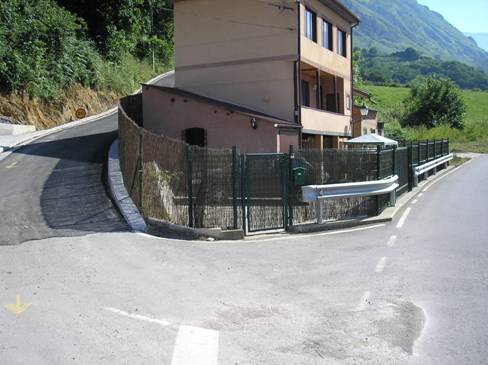
Pola de Lena is to the Vuelta what Cortina d'Ampezzo is to the Giro, or at least in an ideal world it is. It sits at the basis of the Alto de La Cobertoria, one of Spain's iconic climbs, and also at the base of the short and steep Alto del Cordal, used regularly as Angliru's lead-in. There's also Cuchu Puercu, the summit of which links the two aforementioned climbs. To the south, a period of false flat leads in to either the famous Puerto de Pajares (or Cuitu Negru, the summit above it, of course) or the as yet unused Spanish Galibier, the Puerto de la Cubilla. To the east lies Coto Bello, discovered in 2010 and promptly forgotten again despite being the site of Mikel Nieve's first career win after the awesome Euskaltel mountain TTT to pull him across to the break on Cobertoria. And slightly to the north is the short and steep Alto del Carabanzo, the climb that served as the fulcrum for the attack that gave Amets Txurruka his first career win. This is a town of greatness, so it's only fitting that it begins the hostilities for the day. And what hostilities they are, for we start immediately with the hardest climb of the day, and probably the hardest climb that Pola de Lena has to offer us: the eastern face of La Cobertoria.

cob_pol_14.png


This brutal side of the ascent has 5km at over 11% in the middle, yet despite the fame and popularity of La Cobertoria in La Vuelta, this is the side that has historically been descended; it's only in recent years that Unipublic have opened their eyes to what they have here, introducing it in the 2014 stage to La Farrapona as a mid-stage challenge. It was used in a much more focal point in the 2015 stage to Ermita de Alba although in recent Vuelta style, utilizing tough gradients on the final climb ensured action on La Cobertoria was limited. In the interim it was included in the first stage of the 2015 Vuelta a Asturias, which used it as the penultimate climb in this stage, then descending the classic Barzana side and then climbing the super gradual southern side (why they didn't descent that then climb the Barzana side I don't know; David Belda was winning the stage before crashing on the descent leading to Igor Antón taking the win). Anyway, for all its brutality, here it is a lead-in climb. The pace should be infernal to drop domestiques though - riders will want to get rid of as much help for the opposition as possible to make the late stretches harder to control. After the descent there's then a stretch of downhill false flat before the next piece of brutality.

CruzLinares.gif


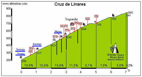
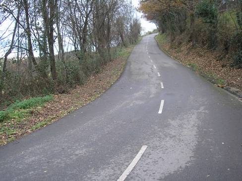
Cruz de Linares is another favourite of traceurs in Asturias; both sides are similar length and similar average gradient, while the road is smooth and well-maintained, plenty wide enough for any race, and yet it starts with 4km averaging 10,9% and including some seriously steep hairpins - a max of 17% is nothing to be sniffed at.

Cruz+de+Linares+%25282%2529.jpg


The descent that follows this painful climb is highly technical as well, which will ensure riders need to keep alert and don't get the kind of respite they might want as while they can turn the legs off, they need to keep the mind on. From here they loop back towards Proaza along 
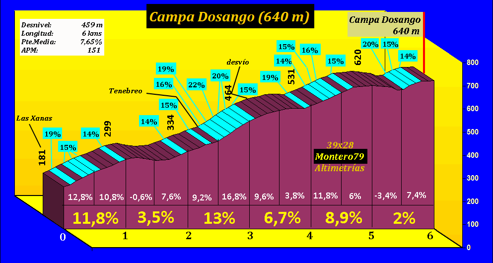
scenic valley roads before the next climb. The Vuelta, from this approach, would typically climb the Alto del Tenebredo, a short but steep climb often given cat.2 status although it varies. They would usually have left out Cruz de Linares too. Anyway, a little above Tenebredo is another summit, the Alto del Campo Dosango. This was brought to many's attention in the great 2010 Vuelta a Asturias final stage, when Constantino Zaballa escaped on San Lorenzo and soloed away over Dosango and Manzaneda into Oviedo to take the race from an ailing Fabio Duarte, who had won on Acebo but had not the support to handle the Loulé onslaught.

Campa%20Dosango%20Tenebreo%20perfil.gif


The road separates from the Tenebredo road at around the 3,3km mark - so you can see the nastiness of some of these gradients and that this is one of the most inconsistent climbs you will ever see, except for maybe La Marta. It crests with 48km remaining and I'm hoping that the heads of state group will be shrunk to its bare essentials by now, only the most super climbing domestiques should still be here.

_wsb_513x479_dosangomorcin006.jpg


The descent is two-stepped, as we stray to the south of the main road to Soto de Ribera that leads towards Oviedo in order to descend into Santa Eulalia. From here, things get very nasty indeed, because with 35km remaining we take on one of the nastiest cat.3 climbs there's ever been, the brief but savage Alto de La Collá. Just 2km long but averaging around 12%, that first kilometre with an average in excess of 15% is going to really be felt given there's no respite after the descent. It's just a sharp right and then se armó un zapatiesto...

lacolladura006.jpg


There are 35km remaining at the summit of this nasty little dig, but the descent - which is wide enough to be comfortable for the main cars etc.. I don't think La Collá will be any problem for the cars given some of the roads Unipublic often make them tackle, but if they do have an issue then the convoy can cut off the climb by going straight from Vegas de San Estebán to the summit on the MO-3, a road which is only very slightly wider, but far less steep. Following here the riders descend and loop back towards Soto de Ribera, where the final intermediate sprint is had, with 26km remaining. We then take on the climb to the Alto de Picullanza (using the Asturianu), which bp92 also used in their Monte Naranco stage, as a much more interesting alternative as a final climb into Oviedo than the more common La Manzaneda. It's slightly longer and less steep than La Collá but it has some nasty ramps of its own, with a maximum of 17%...

PICULLANZASOTO12.jpg


At 21,6km from the line, there may be some moves here, though I anticipate the final climb being where the thinning-out process ends and the carnage ensues. There's a brief flat along the plateau as we head along to the Alto de La Manzaneda itself before descending the wider roads into the Oviedo overspill village of Box, where things get really brutal. Much like Monteabril in the Bilbao stage, the final climb has one of the steepest kilometres of racing and though short, gets cat.2 status.

As a point of reference, the Côte de la Croix-Neuve, aka Montée Laurent Jalabert, the infamous steep climb out of Mende, is 3km @ 10,6% with a steepest kilometre in the middle of the climb at a pretty serious 12,4%. It's one of the shortest cat.2 climbs you'll ever see in a GT, mainly as the Giro is very stingy with categorization, and the Vuelta often gives its own climbs of short length but super steep gradients cat.1 (Xorret del Catí, 3,8km @ 11,5%, for example). Our final climb, the Alto de La Grandota, is slightly shorter than Mende, and half a percentage point less steep. But... it has a steepest kilometre over 5% steeper than Jalabert's peak can muster. That's right, an absolutely face-meltingly brutal 17,9%!!!!!!

La+Grandota+S.gif


Yes, this is a pure garage ramp.

_wsb_500x373_GRANDOTASUR18.jpg


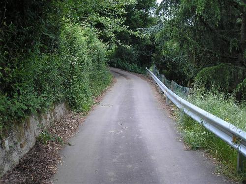
It's stupendously narrow and some parts will need a bit of a clearing. The max gradient is 21,5%, so not too inhuman, but given the problems that Montelupone caused bikes back in 2008 this one could cause carnage. Also, of course, the steepest gradients being near the bottom prevents Murito-itis breaking out. Pacing this one could be mighty difficult, but then if you do attack and get away, you'll be out of sight quite quickly owing to the high sides of the climb. Again, like La Collá, parts of the convoy could skip this part and leave us with skeletal neutral support etc., like we see on the Koppenberg, Alto de La Antigua or some of the most brutal Roubaix sectors. Some of the APM Foro guys have ridden it and given some of the slopes and narrow tracks they use in the Vuelta al País Vasco, it's not too unreasonable. Most of it is like this which seems perfectly acceptable; a new coat of tarmac for parts like this and we're away.

Cresting with just 9,5km remaining, this will obviously see all the toughest action, and earlier moves will possibly meet their demise here. Reaching this after all these climbs in the breakaway will also be a bit spirit-crushing. The first kilometre of the descent is on one-track roads, but is comparatively shallow; after this it's perfectly good roads that are not unlike your usual mountain descents; after this we simply head into Oviedo. The last 3km are very, very straight, but I really don't fear there being large groups together to capture the attack moves. In fact it could be quite soul destroying to see the guy that dropped you on a 20% slope directly in front of you but not be able to get across to him. Anyway, the final kilometre is on a slight uphill drag on Calle Jovellanos before a finish on the scenic Plaza de la Escandalera. This is a beast of a stage and while heads of state may want to keep as much in reserve for the forthcoming stages, they simply won't be given the chance to do so here with some of the ramps in store for them.

Oviedo%20-%20Plaza%20de%20La%20Escandalera.jpg
 
Aug 21, 2015
380
0
0
Visit site
Stage 12

Stage 12: Nice - Barcelonnette 185.8 km

Stage%2B12.png


Stage%2B12.png


Posting a bit late today but the stage tonight should be on time. More climbing is ahead of us today as we hit some more underused climbs in the Alpes Maritimes. We start the stage in Nice and I even spend the first couple km going by the beach so the riders can say goodbye before we hit false flat pretty much all the way up to the first climb in the Col Saint Martin. The climb isn't too hard but it is long and fairly consistent and should wear on the riders quite a bit.

Wearing the riders down is going to be a bit of a theme for today as the next stages are going to have a pretty big effect on the GC including a hilly ITT tomorrow. I also don't want to kill the racing from the day before too much so as many fun combinations as there are with these climbs, I have to keep it somewhat tame. Kinda feel guilty about doing it but we do use some underused climbs and it should be fun to see them. Even if the riders soft pedal the stage today, the climbing should weigh on the legs as we hit the weekend stages.

It should still be a tough stage though, no sprinters winning this one. Once we get over the Col Saint Martin, it is time for a pretty tough climb in the Col de la Couillole. It is a fairly consistent climb but it should wear on the riders and can be a nice tempo grinder to make our next climb that much harder. Both climbs obviously that could be used more often by the tour.

Col_de_la_Couillole_Saint_Saveur_sur_Tin%C3%A9e_profile.jpg


Speaking of the next climb, we hit the highest point in the tour and the Col de la Cayolle. Yeah we start the stage with a couple km right by the Mediterranean and we end up hitting the highest point in the entire tour in the same stage. I was tempted to do a MTF at Pra Loup but I decided that would just mean the riders soft pedal this and wait till the final climb with the ITT tomorrow. Hopefully the downhill finish encourages more attacks on the climb and while the Cayolle is a fairly consistent climb, there are a couple sections where things get steep and they could be a nice launch pad if anyone is willing to attack.

Col_de_la_Cayolle_Saint_Martin_dEntraunes_profile.gif


We get a downhill finish in the beautiful Barcelonnette after the climb, it is a fairly long descent and not as technical as the Turini of course. It should still be a fun chase for the stage win and in the event any GC men make a go for it. This would be another stage that could very realistically happen in an actual Tour. We just finished at Pra Loup last year and just look at the infamous stage from the 1975 route that takes on the Saint Martin, Couillole, Champs, Allos, and finishes at Pra Loup and was where a certain rider lost the yellow for good(although getting punched in the kidney on the Puy de Dome stage couldn't have helped). They have that stage being 217.5 and they could easily make it shorter if that is too long(although it seems like a great queen stage to me). The Cime de la Bonnette is also another option to hit although there is quite a bit of flat hitting it from the south. There are a lot of options to go from the Nice area to this area in one stage that are very feasible.

barcelovg3.jpg

Barcelonnette, site of the stage finish

Next stage for the riders will be a hilly ITT starting in Chorges
 
Re: Stage 12

52520Andrew said:
Stage 12: Nice - Barcelonnette 185.8 km

We just finished at Pra Loup last year and just look at the infamous stage from the 1975 route that takes on the Saint Martin, Couillole, Champs, Allos, and finishes at Pra Loup and was where a certain rider lost the yellow for good(although getting punched in the kidney on the Puy de Dome stage couldn't have helped). They have that stage being 217.5 and they could easily make it shorter if that is too long(although it seems like a great queen stage to me). The Cime de la Bonnette is also another option to hit although there is quite a bit of flat hitting it from the south. There are a lot of options to go from the Nice area to this area in one stage that are very feasible.

Hehehehe: :cool: . Once you finish your TdF, I'll start posting mine, including a...Nice-Barcelonnette different from yours and very '75ish. Great route so far, props to you.
 
Stage 15: Grado - A Pontenova, 217km

6fb7g8.png


20ho8ky.png


GPM:
Pozo de las Mujeres Muertas (cat.2) 7,4km @ 7,0%
Alto de las Pedras Apañadas (cat.1) 13,2km @ 6,9%
Alto de Ouviaña (cat.2) 4,6km @ 10,1%
Cruz de Meira (cat.2) 6,7km @ 8,9%
Alto de A Barranca (cat.1) 6,2km @ 10,4%

Still no more MTFs in the race, on the penultimate Sunday, but another day, another set of garage ramps. Riders are going to be starting to get fed up by this point.

panoramica%20grado%20desde%20la%20portiellarecortada%20(904%20x%20581).jpg


A very short transfer from Oviedo means the riders will at least have had a decent rest before they have to set off on a long and arduous stage that takes us out of Asturias and into Galicia. The starting town of Grado is known to cycling fans for two things. One: sitting at the base of the Alto de la Cabruñana, a small Asturian climb that often features in the early build up stages of the Vuelta's jagged Asturian stages, and two: Santiago Pérez. Santi exploded onto the scene when he went full berserker mode in an attempt to win the 2004 Vuelta from nowhere, suddenly dropping the mountain goats repeatedly and even winning the closing flat time trial, but not taking enough time. After this turned out (shockingly!) to be a Clinic matter, Santi was banned and never made it to the top level again, riding utterly anonymously for Relax-GAM in 2007 before being exiled to Portugal, popping up annually to have a serious tilt at winning his home race.

The stage opens with Cabruñana, but gives no points for it; the opening ramps are missed off as the town is above them, and it's not all that difficult. After that, as we move into the less populated western part of Asturias, it's mainly valley roads, at least until we get to Cangas del Narcea, the largest town in this neck of the woods, and as a result both a regular supporter of the Vuelta a Asturias (paying for the Santuário del Acebo finish!) and a favourite of traceurs owing to its position close at hand to a number of serious climbs.

maes40.jpg


One such climb is the Pozo de las Mujeres Muertas, which translates as Dead Women's Well. The actual summit is slightly above the infamous Pozo, and is called the Alto del Valvaler; while the Vuelta would perhaps go with the latter, the climb is almost universally known to cycling fans by its more evocative name. This is hardly unique; what traceurs know as El Purche is known to Unipublic as the Alto del Monachíl, and what traceurs know as the Alto de la Sierra Morela is known to Unipublic as the Alto de Folgueiras de Aigas. Anyway... I used the southern side of the climb in my third Vuelta route, but the difficult two-stepped northern side remains unused, while the shorter eastern face now gets a run-out. With 3km @ nearly 11% in the middle of the climb, it's pretty serious stuff, but is only a taster of what's to come in this sawtoothed second half of a stage.

pozo+059.JPG


We then descend the tricky San Antolín side of the climb before crossing into Galicia, where the main sparring of this stage will take place. The next port of call is the longer and grinding Pedras Apañadas, which has a similar average gradient to Pozo, but no false flat, and in fact apart from the one steep ramp is far, far more consistent a climb than anything else we've faced or will face in the weekend's stages. These isolated roads also lend a tranquility to the racing that belies the brutality that is in store later in the stage.

3976446.jpg


After an intermediate sprint in A Fonsagrada, a small mountaintop town which has hosted the Vuelta a couple of times but doesn't sit at the top of any major climbs, therefore yielding a short punchy finish after some flat following a steep climb, which has never been really properly utilized by the Vuelta, there's a long undulating period of uncategorized rises and falls which gives way to a more sustained descent, which starts off fast and straight and ends up quite technical lower down. This leads us into our trifecta, a triple-header of nasty medium-sized climbs with horrible gradients to break our tired bunch up once more. First up is Ouviaña, the shortest of the three, but with an average of over 10% and a max of 18% this one is still pretty tough. Its characteristics, with the steep ramps at the base (the first 3km average 12,2%) and the painful hairpins, bring to mind something between Peña Cabarga and Mende. It's narrow and fearsome, and after cresting with 48km to go, the road widens out and we get a perfectly acceptable descent, but we're only a third of the way through the troubles.

Cruz%20de%20Meira%20por%20Chao%20do%20Pousadoiro.gif


Next up is the nasty Cruz de Meira, although this isn't the nastiest side - there's another route which exits the main road slightly earlier and measures up 200m longer and 0.2% steeper, however there are enough narrow hellslopes in my Vuelta already, so I stay on nice wide - but still steep - roads until the 5km mark, when it gets properly narrow. That 4km at 10,2% in the middle - culminating in the max gradient of 17% - may tempt some who desperately need time as the summit of the climb is 33km from the line. The summit is a Parque Eólico with some narrow but good condition roads.

item.JPG


A steep, narrow and technical descent follows as we return back to the Rio Eo, before our final climb of the day, and it's a really savage one. Just as yesterday La Grandota was cat.2 despite just 3km in length, A Barranca is cat.1 despite just 6km in length. The Vuelta quite frequently "reaches" in terms of its mountains points, giving out cat.1 for some shorter, steep climbs like the Alto del Cordal, Peña Cabarga or the Puerto de Urkiola which, though steep, should probably realistically garner cat.2 (the Tour is not exempt from this either, La Planche des Belles Filles is no longer than these, slightly less steep and still gets cat.1). A Barranca is a full % point steeper than the toughest one of those (Peña Cabarga) and 500m longer than the longest of those (Urkiola). It has a steeper max gradient (21%) than any of them and a steeper full kilometre (15,4%) than them too...

a-barranca_eo_13.jpg


Cresting at 17km to go, this brute of an ascent will no doubt see serious GC action on its dramatic sweeping hairpins, though it's perhaps the pure garage ramp sections that will interest fans most. Of the three well-known nationalities within Spain (as in, non-Castilian groups), Catalunya is mostly famous for long, comparatively gradual slopes, while País Vasco is all about the shorter but brutally steep climbs. Galicia has some of both, and here we are dealing with something more Basque and yet simultaneously longer at those ludicrous gradients than you typically get in Euskadi. This is really nasty. It's also very inconsistent in terms of route as well; although always narrow and steep, some sections are through blocked off forest while others are exposed to wonderful mountainside vistas, so if the sun is beating down, constant changes in temperature regulation will factor into the racing as well.

item.JPG


With the finish so close they can smell it, there's now just time for one more long and while not wide, not super-brutal descent to take us to the finish in the small town of A Pontenova, famous for Os Fornos and arguably (because of the resorts) the smallest stage host of the race. After 220km of this kind of suffering, tiders will be ever so glad there's only one stage before rest day number 2. The riders will overnight in Lugo, so the small size of the stage town (though at around 3500, still double that of Jausiers, which hosted the Tour!!!) shouldn't affect anybody too badly...

15741846.jpg
 
Oct 4, 2015
417
1
3,030
Visit site
Awesome stages everywhere. Brutal walls in Spain, nice high mountains in Barcelonnette.

Giro d'Italia Stage 16: Boario Terme - Val Masino, 161km (****)
35k62c2.png

dy2lpz.png


Climbs: Colle di Zambla (13.8km @ 5,8%), Passo San Marco (20,1km @ 7,2%), Val Masino (17,5km @ 5,1%).

After a well-deserved rest day, the climbing picks up again with another high mountain stage, featuring the second-to-last summit finish of the race in Val Masino.
The climbing starts of relatively early, with only 13 flat kms before the start of a hilly section, which precedes the very first climb of the stage, the cat.2 Colle di Zambla.
ZamblaE.gif

After a long and irregular descent, which actually includes a short uphill bump before the longer downhill section, comes an easier section, which gradually transitions into the stage's hardest climb, the long Passo San Marco. A difficult climb, which could create big gaps should someone try to make a move here.
SanMarcoS.gif

Then comes a long, very technical descent to Morbegno, after which we start the ascent to the summit finish in Val Masino. An irregular climb, very similar to the climb to Val Malenco, which is actually in the same area.
BagniDiMasino.gif

Not the hardest mountain stage, but we've had plenty of those anyway. There might be some surprises, though, if there are attacks from San Marco.
 
Aug 21, 2015
380
0
0
Visit site
Stage 13

Stage 13: Chorges - Station Montclar 51.3 km (ITT)

Stage%2B13.png


Stage%2B13.png


Next up we have the hilly time trial. It is another long one but we also have 3 climbs to keep the riders busy. The first 2 climbs will also serve as time checks as well as the third time check in Selonnet. The climbs will not be terribly steep but there is not much flat in the course. I did not want to go too crazy with the climbs as the climbers will have their own time to shine but it is definitely not flat and I would imagine we see the road bikes for this one. One thing I should note is that there is a tunnel on the descent of the Col Lebraut which kinda messes with the track view. I have it edited in the profile but that bit of red on the descent on the map is it acting up.

The finish for the stage is at Station de ski Montclar after a long drag up. Pretty straightforward stage for the most part, there is a nice set of turns at the bottom of the Col Lebraut which could be interesting as it cost a rider seconds if they take the wrong line. The story is similar descending the first part of the Garcinets although that road is a bit narrower before the road straightens out a lot more at the bottom half of the descent. Should be a fun stage for the GC men to try to earn some seconds. This is the last time trial so after this, the only way to earn times is on the road stages and more than likely in the mountains.

Ski_parapente_St_Jean_020.sized.jpg

Station de ski Montclar where the stage will be finishing

We have a fairly sizable transfer after today to Grenoble so that won't be much fun for the riders but things should go smoothly once they get there. We are now hitting the weekend stages and this will be the time for the climbers to start to really claw themselves back into this race.
 
The one minus wrt this thread is that stages are very spread out. I keep having to look back to see the progression of GTs in particular and really get to appreciate the designs. How feasible would it be to save all pics, profiles, and narratives to folders in our computers, and post them back-to-back-to-back, or maybe one week at a time?
 
Tonton said:
The one minus wrt this thread is that stages are very spread out. I keep having to look back to see the progression of GTs in particular and really get to appreciate the designs. How feasible would it be to save all pics, profiles, and narratives to folders in our computers, and post them back-to-back-to-back, or maybe one week at a time?

The library was rendered useless with the latest forum update. Sometimes posters link to all their stages in a single entry, which helps.
 
I got to about page 120 in terms of cataloguing the library to rebuild it, then real life kind of got in the way and I've been very lax in going further with it, partly because of time and other commitments, and partly because I've got distracted by doing more routes for posting, which is my own fault I know.
 
Re:

Libertine Seguros said:
I got to about page 120 in terms of cataloguing the library to rebuild it, then real life kind of got in the way and I've been very lax in going further with it, partly because of time and other commitments, and partly because I've got distracted by doing more routes for posting, which is my own fault I know.
120 pages...a day? LS, you're slacking :D .
 
Re:

Libertine Seguros said:
I got to about page 120 in terms of cataloguing the library to rebuild it, then real life kind of got in the way and I've been very lax in going further with it, partly because of time and other commitments, and partly because I've got distracted by doing more routes for posting, which is my own fault I know.

Tbh even starting a library or cataloguing a library deserves plaudits, and posting new routes is about 53 times as fun as creating a library, so that is utterly understandable. :)
 
So many great stages in the last few days by all of you, and I hope this one isnt bad too ;)

DACH Rundfahrt stage 15: Schwaz - Kühtai (202 km)

difficulty: *****

CLMcYsr.png

IkFLPje.png


We are on the penultimate sunday and of course that means that the riders have to face another monster stage. The stage starts in Schwaz, a city in the middle of the Inntal a valley which goes through the biggest part of Tyrol. The first 40 kilometers are a warm up because they are basically the only flat 40 kilometers of the whole stage, because the rest goes up and down all the time. There is also an intermediate sprint only 27 kilometers after the start, in the capital of the state, Innsbruck.
vcLdje3.jpg


Then the first climb of the day, up to the Seefelder Sattel starts. The climb ends (surprise surprise) in Seefeld, a town famous a nordic skiing resort. Each year there are nordic combinations in Seefeld, when the olympic winter games were in Innsbruck. Moreover in 2009 it will host the nordic skiing world championships, so the cross country skiing events will also take place there (so Libertine probably already knows everything about the town). The climb up there is brutal. It flattens out at the end but the first 3 kilometers are over 10% steep, so anything but an easy climb to start the day softly. Once again that climb should make sure that the break of the day is relatively strong.
tXmKH5W.gif


After the descent there is another intermediate srpint, but right after it the next climb already starts. However the Holzleitensattel is by far easier than the the Seefelder Sattel, although it is over 13 kilometers long. Thats because an average gradient of 3% called also be called false flat, but it will still make it more difficult to control the whole stage. Next up is the Fernpass, another not very steep pass. And once again hardly any flat before the next ascent, which goes up to Berwang, and after the next short ascent up to the Namlossattel the almost 100 kilometers of almost steady up and down, on rather easy climbs finally ends. However thats not because there aren't more climbs, but because the rather easy climbs become, classical alps passes.

First of all, the Hahntennjoch, a climb which was used in this years Österreich Rundfahrt. However it was used from the more difficult east side, while I use the more easier west side. But don't think the climb is easy only because its not as hard as from the other side. Its maybe only a 1st category ascent, but especially the last few kilometers are really steep and should make the peloton much smaller. Maybe there are even some attacks on the Hahntennjoch, because tomorrow is a rest day so there is nothing to hold back. However to be honest, thats not very likely considering what is still to come. The descent isnt very technical with only 4 switchbacks, but the gradients are pretty steep so the riders will probably go down there with a very high speed.
LopXlAp.jpg

rfC4PPl.gif


The riders then go through a short valley, which is probably the longest flat section after the 40 k's at the beginning, although these 10 k's aren't even really flat. Then about 20 kilometers before the finish the riders start to go uphill again, and this time its even more serious than on the Hahntennjoch, because the Silzer Sattel is 9.6 kilometers long and 10.6 % steep. These numbers are comparable to some of the most famous passes of the world, like for example the Mortirolo. Shouldnt surprise anyone that this is another HC climb and also one of the hardest climbs of the whole tour (but not the last climb of the stage yet)
cHvyNJP.gif


To be honest, some of you might say that these two last climbs of the stage are actually only one, because the descent between is only 2 kilometers long. However the last ascent, up to the Kühtai, is completely different because its a flatter, but more irregular climb, and because of the lower average gradient I hope that some riders will already go for an attack on the penultimate climb, so we will see more action. I also don't think thats unlikely to happen, because the Silzer Sattel is one of the best options to go all out in the whole race. As already mentioned, the finish is on the Kühtai, once again a famous skiing area. Last year the city hosted two world cup races, for the first time, which were a women's slalom and giant slalom. The town also has already hosted a mtf in a cycling race, which was in 2013, when Kevin Seeldrayers won the first stage of the Österreich Rundfahrt of that year.
HV3dDcg.jpg

e5oI3H7.gif


This stage is extremely hard. Its a steady up and down, and the last 20 kilometers aren't only extremely hard, they will also be raced extremely hard, which might make this the most difficult stage up to this point. The time gaps might be huge riders who aren't very good in ITT's actually have to go all out, because they wont get many better chances to get time on good TT'ers.
 
While everybody else seems to be designing GT's nowadays, I'll come up with something more simple: a world championship.
While Richmond was an enjoyable race, I think it could have done with something extra. Let's say: cobbles, and short steep hills. And short steep cobbled hills. And cycling-mad crowds.

Therefore: (...drumroll...) a world championship in Oudenaarde and Ronse.
The TT's wil be held in and around Ronse, the road races in and around Oudenaarde.
There will be 2 distinctive courses in Ronse and 2 in Oudenaarde which will be used in a different way for each race.

Ronse:
Start and finish of the TT's will be at the Veemarkt in the center of town.

Course 1:

168ef87.jpg


The first course is a clockwise lap of about 15.3km, mainly north of Ronse.
Immediately after the start there's a 90° right hand turn, and then the course heads west for about 3.5km. A smooth right hand turn is followed by 500m false flat which initiates the 2-stepped climb to the Hotondberg, the highest point of the province of East-Flanders and location of a cyclo-cross event in early october.
The actual descent is quite short and followed by a slowly descending ride of about 4km on a straight, wide road. Then comes a sharp turn and the descent back to Ronse, which debauches in to the long straight of the N48, about 1.5km long, before a final left hand turn leads to the finish.

Course 2:

2hhpqps.jpg


The second course is a counterclockwise lap going around Ronse. It uses the same roads as the first course, but in the opposite direction. This results in a slow uphill false flat to the "summit" of the Hotondberg after the initial flat 2.5km. This stretch of the race is really suited to the big engines. Then comes a fast descent of about 3.2km, followed by the part of the course going south of Ronse. First there's 7.5km of flat roads, but then a lost jewel shines on the horizon: the main difficulty of this course will be the climb of the Mont Saint-Laurent, aka the Côte des Hauts or Côte du Beau Site.

2zyx1md.gif


4j83d5.jpg


It is probably one of the most difficult, and most scenic, cobbled climbs in the region, but since it is in the French-speaking part of Belgium, it isn't used (anymore) by the Flemish one day races. After the cobbles, there's about 1.5km on a plateau, after the gradual descent into Ronse, passing an old wooden windmill in the process.

The TT's will be as this:
men TTT: 2 laps on course 2 (54.6km)
women TTT: 3 laps on course 1 (45.9km)
junior women TT: 1 lap on course 1 (15.3 km)
junior men TT: 1 lap on course 2 (27.3 km)
U23 men TT: 2 laps on course 1 (30.6km)
women TT: 2 laps on course 1 (30.6km)
men TT: 2 laps on course 2 (54.6 km)

Oudenaarde

Course 1:

2ldefyr.jpg


The road races will start on the market square, in front of the small but beautiful medieval town hall. Then the course will go by the "centrum ronde van Vlaanderen" and leave the town center when crossing the Scheldt river and heading for the N8. After about 4km the finishline is crossed for the first time. This will be at the same road where the finishline of the Koppenbergcross is drawn, only about 2.5km closer to Oudenaarde. But no Koppenberg. Yet. Instead the course heads southwest for about 12km, until the climb of the Kluisberg (only the first 1.1km on the profile), 6.5km later followed by the Knokteberg or Côte de Trieu. 2km on a plateau are followed by the descent of the Hotondberg that was also used in course 2 of the TT. But instead of aiming for the Côte des Hauts, the course climbs the Kapellestraat in Ronse (600m @ 9.5%) and descends the better known Fiertelmeers. After climbing out Ronse (1.6km @ 4.4%), the course cross uses some lesser known roads in the Flemish Ardennes, including the Donderij (uphill false flat cobbled road of 1500m), Berg ten Houte and the Boigneberg. Then there's 8km, mainly on wide flat roads to the beginning of the next lap.

Course 2:

jk81f6.jpg


This course is best described as Richmond on steroids. And maybe some epo and growth hormones too.
After crossing the finishline, there's 2.5km on the wide, straight Berchemweg to Melden. This stretch of the course will invariably be used to fight for good positions, meaning that despite it's rather featureless, the pace will be high and it will add to the overall difficulty of the race.
Then the first difficulty of the short local laps rears its ugly head: the Koppenberg: 600m of cobbled madness, ensuring chaos in many editions of the Ronde van Vlaanderen, but too good to be left aside. From this moment, an almost traditional piece of the course of the Ronde van Vlaanderen is used: after the Koppenberg, the race crosses the N60 and heads for the cobbles of the Mariaborrestraat.

23kx3ti.jpg


This road is almost immediately followed by the Taaienberg. 3km of narrow, exposed roads lead to the last climb of this lap: the Eikenberg. Although cobbled, it lacks the excessive maximum gradient of many of the famous bergs. The last stretch of 4.3 km will decide if a solo rider can take the rainbow jersey back home, or if there will be a sprint of a small group.

The road races will be as this:
junior women: 1x course 1 + 1x course 2 = 70.3km
junior men + elite women: 1x course 1 + 5x course 2 = 139.5km
U23 men: 2x course 1 + 4x course 2 = 173km
men elite: 2x course 1 + 9x course 2 = 259.5km
 
Oct 4, 2015
417
1
3,030
Visit site
Another awesome stage in Austria. The RVV-style World Championship is a fun idea, too.

About the library thing, I'll try to post links to all my stages when I put up the last stage. It's true that it sometimes becomes hard to follow track of races because there are four or five races being posted at the same time.
Making a stage library of a thread like this (228 pages and counting) made over such a long timespan should be a huge piece of work. Many posts are a mess, and many images/links are broken, rendering the stages unviewable (I've had my antivirus even pop out warnings because of images linked from unsafe sites... then again it might be that my antivirus sucks). Also, as it has already been said, it's much more fun to create stages than to create a stage library.
 
Oct 4, 2015
417
1
3,030
Visit site
Giro d'Italia Stage 17: Morbegno - Ivrea, 218km (**)
zv54js.png

24gooko.jpg

Climbs: San Fermo della Battaglia (3km @ 6,4%), La Serra (6,3km @ 4,6%).

After the high mountains in the second weekend/third tuesday, we head west with a much easier stage, between Morbegno and Ivrea. With La Serra only 12km away from goal a sprint isn't very likely. A breakaway may win this too. Those riding for the GC will take it easy today; it's the last "easy" day before the last sunday, after all.
 
Oct 4, 2015
417
1
3,030
Visit site
Giro d'Italia Stage 18: Ivrea - Biella, 30km (ITT)(****)
f5d3cp.png

1z6rqz6.png

Climbs: La Serra (6,3km @ 5,4%)

Stage 18 features a 30km mixed time trial between Ivrea and Biella, with the climb to La Serra from the west along the way. The climb isn't very steep, and the descent is almost false flat, so time trial specialists will probably be able to gain some time here.
Serra2W.gif

However, this late into the race, this time trial will most likely serve as an overall test of strength, heading into the race's final mountain stages.
 
Aug 21, 2015
380
0
0
Visit site
Re: Stage 14

Really nice stage there Gigs

Stage 14: Grenoble - Val Thorens 179.6 km

Stage%2B14.png


Stage%2B14.png


Right, I promised some mountains for the weekend and here we are. This is probably the most cookie cutter stage of my tour just linking climbs together but it is a fairly nice combo so I am happy with it. We start in Grenoble and have a fairly flat first 50 km as we go towards our first climb which should be very familiar to everyone. Yeah it is the Col du Glandon which we went over twice last year(once on the way over the Croix de Fer) and then hit the Croix de Fer on the final stage as well. At least in this case it is the first climb of the day so there is that. It is a very inconsistent climb from this side and it will be hard for the climbers to get a good rhythm.

Col-du-Glandon-Barrage-du-Verney_profile.jpg


After we descend the Glandon, we start the Madeleine up the more regular side. It is a tough climb but since it is more regular the climbers should be able to get a nice tempo going. This may be a great time for a team to ride tempo up the climb and drop a lot of the fat in the peleton.

Col_de_la_Madeleine_La_Chambre_d213_profile.jpg


Then after another long descent, we hit the final climb up to Val Thorens. It is a long irregular climb and although it doesn't get very steep, the riders will be worn down by this point. To recap the week so far, we have had a flat stage, the Turini stage, the Nice Barcelonnette stage, then the ITT, then we just climbed 2 HC climbs. The riders are going to be very tired at this point and they get to climb up to the top of Val Thorens for the finish which is just 8 meters short of being the high point in the tour. It will be very hard to get a good rhythm going on the climb as well and climbers who have lost time from the time trials will be all too eager to attack and make up some time. Should be a very fun battle up the climb.

ValThorensN.gif


Now this stage is pretty much a carbon copy of the 1994 stage that finished in Val Thorens with the exception that mine is a bit longer starting in Grenoble as opposed to Le Bourg-d'Oisans. Kinda stinks it worked out like that but at the same time the alternatives using the same start and finish locations were the Galibier and the Croix de Fer(unless I wanted to go all the way around on the Grand Cucheron). There is too much flat between those climbs and the Madeleine plus I like the Galibier too much to use it as a first climb. That said, a fun queen stage(I have enough climbing in my tour as is but I was very tempted by it still) would be starting in Le Bourg-d'Oisans(It would be about 240 km starting in Grenoble and that is too long for me) and hitting the Croix de Fer, Mollard, Chaussy, Madeleine, and then finishing in Val Thorens. Might cook up a profile for it sometime in the next couple days but it would be a pretty sweet stage and under 200 km.

val-thorens-view-from-chair_1351.jpg


The start for the next stage is at Saint - Pierre - D'Albigny although I would guess most teams will spend the night in Albertville which is not far to the northeast. Another very tough stage is in store for the riders tomorrow.
 

TRENDING THREADS