Tour de Pologne - stage 2. Kamień Pomorski – Koszalin, 176km, ~150m asc, flat (difficult roads)
Start: Kamień Pomorski, Bałtycka, Stary Rynek
Km 0: Kamień Pomorski, Gryficka, 1,9km from the start
Start – km 0: Bałtycka (Stary Rynek) - Basztowa - Mikołaja Kopernika - Mieszka I - Bolesława Chrobrego - Dziwnowska - Gryficka
Finish: Koszalin, Zwycięstwa, Rynek Staromiejski, 850m straight
Sprint 1: Gryfice, Wojska Polskiego, 600m straight
Sprint 2: Kołobrzeg, Kamienna, 250m straight
Feed zone: Ustronie Morskie, National Route 11
Difficult roads:
102-105km - 3km - Gąski - sterrato
107,3-108,6km - 1,3km - Sarbinowo - sterrato
133-135,5km - 2,5km - Osieki-Rzepkowo - plattenwagen
139-141km - 2km - Iwęcino-Bielkowo - plattenwagen
142,3-144,3km - 2km - Glęźnówko-Dobiesław - sterrato
152-154,2km - 2,2km - Grabówko-Pekanino - sterrato/cobbles
160,7-164,7km - 4km - Karnieszewice-Sianów – sterrato
Climbs:
Góra Chełmska - 4km, 2,9%, 3 Cat. 122M
Western Pomerania (or Pomorze Zachodnie) was for a long time outside Poland as part of Germany or independent like in the Middle Ages. It's quite renown for it's beaches and countless amount of lakes. This stage begins in
Kamień Pomorski which has it's name after a stone in Chrząszczewska island (try to spell that; in english i guess it's Beetle Island) just west of the city. It's a relatively small city, port and spa located on the east bank of Dziwna river („Strange” river!?) which separates Wolin island from the main land. It was one of the biggest settlements in Western Pomerania in the Middle Ages. From XII to XVII c. there was now defunct episcopate which was 2nd in Western Pomerania after short lived Kołobrzeg one in early XI c. The remainings of this episcopate are cathedral of St. John the Baptist and a Bishop's castle.
Cathedral of St. John the Baptist.
Stage will
start on the west side (called Bałtycka street) of Stary Rynek (Old Square). Then riders will turn west into Basztowa where they will pass close to Brama Wolińska (Wolin Gate) which is a leftover of city's walls from Middle Ages. It houses a „stone museum” which has fossils of various extinct species like dinosaurs and some of the rare stones ranging from amber with fossils to meteorites. Km 0 is on Gryficka street, basically just outside Kamień Pomorski, 1,9km from the start.
Brama Wolinska with stone museum inside (sign in front of the gate) and Basztowa street in the foreground.
Riders will now go alongside route 103 to
Gryfice where the first
sprint of the day is located. Gryfice is located 30km east of Kamień Pomorski. It was one of the most important cities in Middle Age Western Pomerania. It's known since X c. It was propably one of the political centres of a local duchy and a business center while Kamień Pomorski was a religious centre. It did get city rights in 1262 and city walls around year 1300. These walls are mostly history with only a couple of stretches and two gates preserved (Brama Wysoka – High Gate, Brama Kamienna – Stone Gate). Both of these gates are available to traffic and i think riders will go through both of them.
Brama Wysoka (High Gate) in Gryfice.
Brama Kamienna (Stone Gate) in Gryfice.
Riders will turn north and go through the centre of Gryfice. Beginning from the High Gate they will go alongside Wojska Polskiego street which in most of it's length – 500m – is cobbled (typical city cobbles). This section in the downtown lasts around 1km and it culminates in the first sprint of the day before the Stone Gate. Next stop is Trzebiatów, 17km north of Gryfice.
Trzebiatów is yet another city with long history going as far as Middle Ages when it was a business center competing with Gryfice and Kołobrzeg (our next stop). Before that there was a Slavic fortified settlement from IX c. Trzebiatów's downtown is actually pretty well preserved with most of apartments being from XVII to XIX c. There are well preserved city walls and massive St. Mary's Maternty Church. Outside downtown there is a castle from XII c. (reconstructed in XVIII c.) which belonged to Pomerania's dukes.
Trzebiatów's colorful town square with apartments from XVII to XIX c.
Castle (looks more like a mansion) in Trzebiatów originally from XII c.
After Trzebiatów riders will leave the main road to Kołobrzeg (route 102) and turn into a local route 109 to a coastal town of
Mrzeżyno and then east back to Kołobrzeg through a spit located between Baltic Sea and Przymorskie Lake (Coastal Lake?). Pomerania is well known for lots of spits with the ones close to Łeba, Mielno and Dąbki most known (to the Mielno one i'll come back later). Mrzeżyno has one of the better preserved sand dune coasts (or however you call it) in Poland. After Mrzeżyno road goes east to Kołobrzeg first through Reska spit between Baltic Sea and Resko Lake, then a quite popular coastal spa of
Dźwirzyno and then through coastal forest before reaching the outskirts of Kołobrzeg. The road here is 2-lane and on a good surface.
Kołobrzeg is one of the oldest and history rich cities in Pomerania. It was a very important baltic harbor in X c. Later in years 1000 to 1007 it had an episcopate which was liquidated because Western Pomerania left Poland and came back to pogan religion. Later in the Middle Ages city expanded to the point of being one of the biggest Baltic harbors and became a member of Hanseatic League. After being overtaked by Branderburg it became more of a stronghold rather than just a trade port. Now it's mostly a spa and one of the bigger summer destinations in Poland.
Basilica of Assumption of the Blessed Virgin Mary from XIV c. Destroyed many times through history, last reconstruction after WW2. It has a gothic candelabrum, one of the only five remaining in the world.
An alley in Kołobrzeg.
In Kołobrzeg riders will go just south of downtown where the second
sprint of the day is located. It's on Kamienna street after 250m straight. Then they'll go into national route 11 which goes to Koszalin. After 12km they will reach a quite well known coastal spa of
Ustronie Morskie where a
feed zone will be located. They will keep going with route 11 until the village of
Tymień halfway to Koszalin where they'll turn left into a coastal village of Gąski. In Tymień there is one of the bigger wind power plants in Poland. Actually Central Pomerania is literally packed with these wind power plants with the one in Cisowo (just east of Darłowo) being the biggest.
Tymień's Power Plant.
After Tymień this stage begins to unravel the painful mystery it has. I could get easy and end in a short sprint stage in Koszalin with two or three laps around a hill just outside Koszalin (i will come back to it later) but it would be a bit too easy for my liking. So far roads were mostly 2-lane on a good surface but this time riders will turn into a smaller, but still asphalted road into Kładno village and then to Gąski but they will slightly detour just before Gąski to find the first obstacle of the day.
75km from the finish, just before
Gąski they will turn left into the first section of
dirt road (sterrato). This section is
3km long and it can be divided into half. First half is through plains, second half is on a coastal Kolobrzeg – Darłowo track of varied quality. Sterrato lasts as far as the intersection with the Tymień road on where riders were a couple of minutes before. After this intersection they are back on the asphalt and enter Gąski. As you can see below this dirt road isn't the easiest one as it has quite an amount of potholes on the road. The first half seems to have more sandy, soft surface while second half is more stony, firm.
Sterrato outside Gąski.
Sterrato just outside Gąski on the Kołobrzeg – Darłowo coastal track.
Gąski is a seaside village. It's a relatively big tourist destination in Poland thanks to closeness to much bigger Baltic spa's of Sarbinowo and Mielno and a still functional lighthouse.
Gąski's Lighthouse from XIX c.
In Gąski there are around 2,3km of asphalt before it comes back to dirt. The road now goes to Sarbinowo. There are around 2 to 3km between Gąski and Sarbinowo and these in between kms are on
sterrato. This stretch of dirt is
1,3km long on a quite sandy, soft surface.
Sterrato between Gąski and Sarbinowo.
Sarbinowo is a small coastal fishing village in other parts of year besides summer when it turns into one of the bigger summer destinations in Poland – just look up at the amount of people on streetview. Dirt ends at the entrance to Sarbinowo where it comes back as an asphalted, but still relatively narrow road. After bursting through Sarbinowo (in early august propably overcrowded) riders will reach a wider road and the outskirts of Mielno.
Beach in Sarbinowo.
Thankfully this stage is mostly on the Baltic coastline in the middle of summer so this stage will propably be overcrowded. Maybe not like 2014 Tour in Yorkshire or Basque country in 2011 Vuelta but not that far from them. 5 km from Sarbinowo are the outskirts of Mielno.
Mielno is one of the most known and visited Baltic spa in Poland. Crowds might be bigger than in Sarbinowo as like there riders will burst through the centre to reach Jamneńska (Jamska) spit. Mielno is known since XIV century when it was a fisherman village. It has a church from XV century which is known as The Transfiguration of Jesus Church (church names in Poland are much more interesting than the french counterparts where most are just Notre-Dame). Now it's a coastal spa town basically all year long.
In Mielno there is an intersection between a road back to Koszalin (route 165) and road through Jamneńska spit to another Baltic spa – Łazy. Riders will go alongside the road to Łazy which is practically 2-lane on a good surface. They'll burst through the centre of Mielno and then reach the adjacent coastal town of Unieście. Unieście lies in a spit between Baltic Sea and Jamno Lake, it's basically united with Mielno and is similarly popular amongst tourists. The terrain between Unieście and Łazy is forested and it belonged to Polish army up to 1995. Now the abandoned army installations are a local tourist attraction.

Next stop is a medium sized coastal village of Łazy which is squeezed in between Baltic Sea north, Jamno Lake west and Bukowo lake east. It's not as popular as Mielno or Sarbinowo but it's much more quiet. Between the village and adjacent Bukowo lake there is a protected forest and peatbog with some rare plant species. In the village riders will turn right into Koszalin on a quite wide, fine surfaced road which goes alongside east coastline of Jamno lake. 3 km after Łazy riders will reach a village of
Osieki. It's a quite old village with history reaching as far as XIV c. It has a St. Antoni Padewski's Church from XIV century which in XV century was a popular pilgrimage destination because of a supposed bleeding host. In a park between Osieki and Jamno lake there is a mansion from 1924 builded by Hildebrand family.
Mansion in Osieki.
In Osieki riders turn left into a road that was featured in Libertine's Tour de Pologne. It's a „two-lane”
plattenwagen road from Osieki to the village of
Rzepkowo. Lanes are separated by a patch of grass. This road isn't in the best of shapes as these slabs of concrete aren't evenly put. This road is
2,5km long and it's in a very open area so there can be a bit windy. I'm not sure but i think this road (and another one later on) belongs to the EuroVelo Route 10 which is an international bike track which goes around Baltic Sea.
Road between Osieki and Rzepkowo.
In Rzepkowo riders will turn right into an asphalted road which after a 1km or so comes to a much wider Koszalin – Darłowo route 203. They won't have much time to relax because after 2km they'll enter Iwięcino where a next obstacle awaits.
Iwęcino is a relatively big village with a church and an old cemetery from XIV c. in the middle. The road to Darłowo turns right but riders will keep going straight. This road they'll take is at first a quite narrow asphalted road but when the village ends it turns into a
plattenwagen road similar to the Osieki – Rzepkowo one. This road can be a part of the earlier mentioned Route 10 bike track. It lasts 2km and it ends just before first buildings of
Bielkowo where it turns into a narrow asphalted road to then reach the Koszalin – Darłowo route 203.
Road between Iwięcino and Bielkowo.
Riders will stay on the Koszalin – Darłowo road for roughly 1km where in a small village of
Glęźnówko they will turn right into
Dobiesław. This road is on
sterrato which at first glance looks rather smooth and firm but in a small forest between these villages it changes into a cavalcade of
potholes and 4x4 wheel tracks. This type of road lasts for close to 1km. When reaching first buildings of Dobiesław it changes into a narrow asphalted road and after close to 1km it changes into a wider road. This road should be unbearable in rainy conditions so if it'll be rainy then i think riders will use an asphalted Bielkowo - Dobiesław road known from Libertine's Pologne.
Road between Glęźnówko and Dobiesław.
Dobiesław is a quite big, lengthy village with another antique church from XV c. Here i had a dilemma as there are a couple of possibilities. I've decided to be easy after Glęźnówko – Dobiesław stretch and stay with asphalted roads for another 7,5km. In the plains east of Dobiesław there are two interesting roads.
1. First one turns left of the main road roughly in the middle of Dobiesław. It's a plattenwagen road similar to Osieki – Rzepkowo one and it goes to the village's cemetary. It then continues as a fine, soft dirt road before turning right where a power plant station is and then continues like that for roughly 500m before changing back into plattenwagen and 300m later coming back to asphalted Dobiesław – Wiekowo road. This whole stretch is 2km long.
2. Second possibility is to turn into this cemetary road like in the first possibility but just after 200m turn right into a quite firm dirt road which goes just east of the village and after roughly 1,2km reach the Dobiesław – Wiekowo road at the end of the Wiekowice village. This road seems to be easier than the first one.
3. Third possibility and propably the hardest one is to continue on asphalt to Wiekowice, then on intersection not turn left but continue straight on a narrow village road (asphalted) for around 3km before reaching a big forest (after tunnel under the Koszalin – Słupsk rail tracks) where the surface changes. Here a Flanders like hell awaits as the road is... i don't know what it is. I know it's unraceable and it's up a cliff. It's like 300m on propably more than 10%. Luckly after this short stretch of dirt combined with potholes, debris and remains of cobbles it changes into a regular plattenwagen where it continues in the forest like that as far as Karnieszewice 4km later. It would be propably by far the hardest obstacle in this stage.
I've decided to go easy alongside the asphalted Dobiesław – Wiekowo road. In
Wiekowo there is a rail cross (this rail track from Koszalin to Słupsk is quite busy). After Wiekowo riders will continue with asphalt for another 2,5km before reaching the village of Grabówko. This easy stretch as a whole lasts for 7,5km.
In
Grabówko riders turn right into
Pękanino from the asphalted road into a soft
dirt road. This stretch ahead is propably the hardest one on this stage. This road has a lot of small rock debris and a slightly grassy field in the middle. Later after roughly 500m quite a chunk of potholes comes to play. It continues like that as far as first buildings of Pękanino where the road turns into
cobblestones for next 500m. They seems to be quite rough and because the road here has a slight uphill tendency, like 3 to 5%, it can be treated as a small Oude Kwaremont. This whole obstacle is
2,2km long and it's 20km from the finish line. Pavement on the right side in the picture below propably will be out of reach for the riders as it will be for the spectators.
Dirt section of the Grabówko – Pękanino road.
Cobbled section of the Grabówko – Pękanino road.
This cobbled road ends on the intersection with national route 6 Szczecin – Gdańsk road where riders will stay for next 5,5km. As a nationale it's wide, two-lane on a perfect surface. After 5,5km they will reach the outskirts of Karnieszewice where they will turn right into a smaller but asphalted road through the village. Before this turn they will pass by a quite lengthy forest where they will be near (but not in) a protected area of fir trees which are very rare on this kind of terrain.
In
Karnieszewice they will turn left into last and longest
sterrato stretch of this stage. It doesn't seem to be as hard as Grabówko – Pękanino one, not sure about Glęźnówko – Dobiesław one. I don't know how many potholes are there but in span of roughly
4km there must be some. This road goes from Karnieszewice to Sianów's outskirts between the town and nearby village of Skibno. After this road ends there are only 10km of this stage left where riders will turn left through
Sianów (close to 8km north-east of Koszalin) where they'll come back into national route 6 for roughly 1,3km over the rivers of Polnica and Unieść and then in the adjacent village of Kłos turn left into a road that was recently modernized.
After passing Kłos there are still 7km left. Now we're in the forest surrounding Koszalin from east. This road we're taking now is known from Tour de Pologne. It was used quite extensively at the beginning of this millenium, just before TdP went world tour back in i think 2004. I guess if there will ever be an edition where TdP will begin in Gdańsk and end on Orlinek then Koszalin may get back into cycling map with it's little suprise.
This road we're taking is going through a forest east of Koszalin. This forest is on a little massif which is known as
Góra Chełmska (Chełmska Mountain). The highest point, close to the road, is known as Krzyżanka (136m a.s.l). Krzyżanka could be an early Middle Age pogan cult site before it turned out into a chapel or even a monastery in XII c. which was destroyed in XVI c. It was supposed to be a quite busy and popular place at the time thanks to an early gothic triptych on the gloryfication of Virgin Mary. Nowadays a new sanctuary on the remainings of last one was build in 1991 which of course functions to this day.
Sanctuary on top of Krzyżanka, highest point of Góra Chełmska.
This hill, on profile as
Góra Chełmska, is
4km at 2,9% and it's a cat. 3 hill. First over the top here will obviously wear the KOM jersey which if i remember is gray (or pinkish). This hill is very shallow, mostly flase-flat with only a short 100m stretch at max 7%. Regulary such hill shouldn't even be seen by sprinters but after many stretches of bad roads riders are propably very tired at this point so this hill may be more difficult than it is (Aprica case). I don't think it would be hard enough to make any selection but it could wear out some of the legs for the final dash into finish line. This hill have much more punch from the other side (descended one) where it's 1,3km at 5,5% with a 500m stretch at 7%. Top of this hill is roughly 4km from the finish line.
Profile of Góra Chełmska.
After the descent ends there are 2,7km left in the city. Run-in (Piłsudzkiego & Zwycięstwa streets) is not complicated as there is only one 90deg right turn 850m from the finish line, rest is on a straight, wide road.
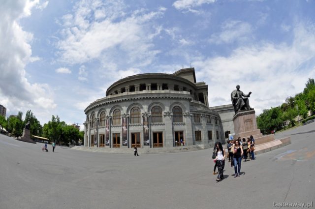
Finish is located on Zwycięstwa street on the city's main square – Rynek Staromiejski after 850m straight line.
Koszalin's main square – Rynek Staromiejski.
This stage is most propably the hardest stage of this Tour de Pologne. I don't think any of the short but sharp polish hills (maybe with exception of Gubałówka and some of those monstrosities in Karkonosze like Stóg Izerski or Przełęcz Karkonoska) will generate such big time differencies this stage could generate. Most of such stages will be used to generate a couple of seconds at best unless somebody will bonk hard.
I predict that this stage will end in a resistance based sprint of a very selected group, maybe 5 to 10 riders with another slightly bigger group close to 1 minute behind. It should be won by a nord classics specialist which won't be at Eneco Tour. I wonder if Kwiatkowski wouldn't try something on the last climb to have a chance at winning the stage, take bonifications and maybe even a couple of second on rest of the pack. Maybe some french flahute with some punch known from breakaways like Senechal, Vachon, Delaplace, Roy or Ladagnous (Tonton propably know 'em better) could be a fine dark horses for this stage (and GC?) or now reborn Erviti. I doubt about much better known Alaphillipe because he'll most propably be in San Sebastian.
I was wandering around Koszalin a bit and this terrain isn't bad for hardcore cycling. The easiest idea i can think of is a 28km hilly TT through Węgorzewo with two easy cat. 3 hills of Maszkowo – 2km at 3,3% and mentioned Góra Chełmska – 4km at 2,9%. Other idea is to try and idolize a narrow, 4km long first plattenwagen then sterrato road from Wyszebórz to Maszkowo through Policko. If i remember this road is very difficult and quite hilly too. It could be linked with Góra Chełmska by a 10km long Węgorzewo road. Next idea would be to try and make use of some sterrato roads north of Kędzierzyn (a village close to Koszalin) maybe with a 1km long cobbled road in the forest between Wierciszewo and Karnieszewice.