Race Design Thread

Page 228 - Get up to date with the latest news, scores & standings from the Cycling News Community.
Oct 27, 2015
86
0
0
Stage 19 [Friday] : Tarbes – Langon
Flat – 200 km

Climbing : 1096 m


Yesterday being the last mountain day, the sprinter may now rejoice : we’ll stay on flat ground until the end. In a Tour with fewer than usual possibilities for them to get a stage win, they should take two of the three remaining stages (the other one being tomorrow’s ITT).
For the GC, today’s stage being sandwiched between a monster mountain stage and an ITT will undoubtedly result in an unofficial rest day.
The riders will start from Tarbes, and head for Langon on the Garonne river. If there are a handful of (very) small bumps in the first half of the stage, the second part is completely flat.
I guess the summary of the stage is quite easy : early breakaway – sprinter teams bring them back with a few km to go – mass sprint. Probably a borefest, but this kind of stages has to happen once in a while (and to be honest, the design was more driven by ‘wine of the day’ considerations than sporting reasons)
langon.jpg


Wine of the day :
Just a handful of km to the southwest of Langon lie the village, and most importantly the vineyards, of Sauternes. It produces a sweet white wine known worldwide. If Sauternes are known for their sweetness, the best of them present a very fine balance between sweetness and acidity. Bottles of Sauternes age very well and can be kept for dozen of years (they usually reach maturity at around 10-15 years). They go very well with dessert or foie gras.
The grapes used are mainly Semillon with a bit of muscadelle and/or white sauvignon.
Thus today’s wine of the day is the Rolls-Royce of all Sauternes, Chateau d’Yquem :
chateau-d-yquem-1991.jpg
 

Attachments

  • route_stg19.png
    route_stg19.png
    70.3 KB · Views: 2,263
  • tdf_v1_stg19.png
    tdf_v1_stg19.png
    39.4 KB · Views: 2,264
Giro d'Italia stage 11: Genova - Sestri Levante (171 km)
lYE3omE.png

1MIFOgo.png


Already some time ago again since I posted the last stage, but just to remind you, it was a flat stage finishing in Genova. But of course the riders won't leave this part of Italy without having to deal with some serious climbs and in Liguria it has to be a medium mountain stage.

The start is still in Genova, but not even 10 kilometers after the start the route already starts to ascent with the Monte Fasce a very difficult 2nd category climb which will ensure a good break and some beautiful camera picks.
85WnPd1.jpg


There is a very scenic flat section after the top of the climb, before the riders descent and arrive in Rapallo after another short uncategorized bump. After an intermediate sprint there the next climb is the 3rd category Passo della Crocetta, a from this side relatively flat climb with a very technical descent. This climb is directly followed by the slightly more difficult and therefore 2nd category Passo die Romaggi.

Up to this point the stage was difficult but everything was still too far away from the finish to cause any action and mainly there to hurt the domestiques. Tbh the next climb will probably also not cause any attacks, but that doesnt change the fact that it's by far the hardest climb of the day. It's the Passo del Ghiffi a climb with an extremely difficult 2nd half.
GhiffiN.gif

DSC02785.jpg


These last kilometers are a place where something like a counter break could form and where a team could possibly let the peloton explode. You might say that this would be something strange to do so far away from the finish in the middle of a gt, but half of the mountain stages are already over and if you already have a big disadvantage you should take every chance you get.
However although the rest of the stage is also always up and down the next climb will make long range attacks much more difficult, the long and not very steep Passo della Biscia. Though not as difficult as the Ghiffi, if someone is isolated even a climb like this can cause problems for you and the average gradient also is only that low because of a short descent in the middle of the climb, there are still a few kilometers with gradients of over 7% and some stretches of up to 10%. And another interesting factor of this pass is its much steeper and very technical descent, which finishes with less than 25 kilometers to go. This is where the real action could start.
12_KurzVordemPasskl.jpg


The reason why the action could start after the descent is because you can split the remaining part of the stage into 6 sections. 3 short ascents and 3 short descents and nothing else. The first climb is the easiest one and only a little bump to the town Zerli, but the descent is extremely narrow and difficult. The first chance for riders like Nibali to attack, especially if the road is wet.
The 2nd climb, the Colla della Chiappa is the most difficult one with about 3 kilometers at almost 10% and although maybe not quite as difficult as the previous one, the descent could also be crucial.
gmhkufe.gif


And then the last climb is the Villa Azaro, another 4th category climb, which is however a little bit flatter but just as the other two also has a very technical descent, which leads the riders to the finish in the scenic city Sestri Levante.
116258_b.jpg


This combination of 3 climbs should be very interesting to watch. Firstly because the battle for the stage should be great, no matter if it is decided in the break or between the riders from the peloton. Secondly there could be time gaps between gc riders. None of those climbs is extremely hard but as I said there aren't as many options to gain time left, as they usually are after stage 11. The descents are extremely technical so you can definitely attack there, and the steep gradients of the penultimate climb could also be difficult enough to cause time gaps. Moreover if a team really tries they can make the race hard on the earlier, harder climbs and can isolate some other riders. Anyway this should be a very exciting stage.
 
Stage 13: Auxerre - Le Creusot, 212km

k30v2e.png


2i9htnp.png


GPM:
Côte de Mazignien (cat.4) 12,5km @ 2,1%
Côte du Mergerot (cat.3) 4,6km @ 4,8%
Côte des Brenets (cat.2) 7,6km @ 4,3%
Le Haut-Folin (cat.3) 5,0km @ 4,4%
Côte de la Croix de la Libération (cat.3) 5,1km @ 5,2%
Signal d'Uchon (cat.2) 7,5km @ 4,9%
Côte de Montcenis (cat.4) 2,3km @ 5,2%

It's now a full eight stages since the riders in my Tour de France have seen a climb of greater difficulty than third category, after that challenging opening in the Basque Country culminating in the toughest mountaintop finish of the race being on stage 4. They've raced through the mostly flat western part of the country, with punchy climbs, miniature Amstel Gold Races and even rouleur suffer-fests on unpaved ribin and are now moving through the centre of the country, a part often overlooked in the route designing. However, as we head towards the penultimate weekend of the race, the difficulties in climbing terms are going to be ramped up, and therefore the riders may appreciate the chance to get a bit of a tune-up for the climbing legs on this, a long and potentially tricky stage taking place on the Friday of the second week.

Auxerre%20Cathedral,%20%20Abbey%20of%20Saint-Germain%20d%27Auxerre%20and%20the%20River%20Yonne,%20Auxerre.jpg


We start the stage in the city of Auxerre, capital of the Yonne département where we finished yesterday, so the transfer is fairly short, and also with a large number of véloroutes, it is a cycling-friendly city. It's a wine-producing area - indeed Chablis is a nearby town - which began life as a provincial capital of the Roman Empire on the Via Agrippa. Its historic centre flanks the Cathédrale de Saint-Étienne and the Abbaye Saint-Germain d'Auxerre, although for many their first knowledge of the city will come via the local football team, AJ Auxerre, the first team of Éric Cantona.

The city has plenty of cycling heritage, however. The Paris-Auxerre one-day race is an extremely old event (first run in 1898!!!) which has had periods of non-running and last ran in 2014, its 59th edition in 116 years, however it is now at the .NE level. It only ran sporadically pre-war but in the post-war era it became a reasonably well-reputed amateur race, with the occasional delegation from the Eastern Bloc contending (Tadeusz Krawczyk winning for example). Its peak lay from the late 80s to the mid 90s, when established names like Jacky Durand, Christophe Agnolutto, Benoît Salmon, Pascal Hervé and Cédric Vasseur appeared on the podium. The last "established name" to win the race is Samuel Dumoulin in 2001, though Fränk Schleck came 3rd a year later. In addition to this, the city has hosted the Tour de France in six editions; the first being in 1965 and the last being in 1981. On the last three occasions it served only as a start town, as today; it's hard to argue with the calibre of winners though - Bernard Hinault, Sean Kelly and Johan van der Velde. The last man to win a stage in Auxerre itself was Gerrie Knetemann, in 1979. The city has appeared in Paris-Nice since, but the most recent occasion was as a start in 2003, in a stage to Paray-le-Monial with some hills but nothing too serious, won by Alessandro Petacchi.

avallon-35197-1_w500.jpg


This stage is somewhat tougher than that 2003 stage, and also tougher than the most recent occasion on which the region I'm treading through appeared in Le Tour, which was 2007, in the late week one stage from Chablis to Autun which delivered a promising looking profile but most of the climbing was little more than false flat and eventually while the main sprinters were dislodged, the bunch prevailed, with Pippo Pozzato triumphing ahead of Óscar Freire. My stage is also a lot more geographically interesting than the central stages in the 2009 Tour, although I do expect that similar to that occasion, the break will be favoured here as, with the run of stages to come, riders high up in the GC battle will not be keen to expend more energy than they need to here. It starts off benign enough, passing through historic vineyards and the beautiful walled town of Avallon, but after that there really is precious little flat as the stage moves into the Morvan region, a regional natural park of lush green scenery, low lying mountains and rolling hillside that ought to give us every bit the visual feast we're used to from the Tour.

IMG_3925_Touleur_1.jpg


There will be lots of racing on roads like that, and most of it will be up and down, undulating terrain that will certainly play its role once over 200km are in the legs at the end of the stage. The first categorized climb is essentially two digs with some flat and up-and-down in the middle, before a similarly rolling descent takes us to the Lac de Pannicière.

PANNECIERE_BARRAGE_-_LAC_-_PARENT.jpg


From here the ascents start to get a bit more severe. In that 2007 stage the riders ascended to the highest point in the Massif, Le Haut-Folin, by a very gradual main road, which was granted cat.2 status more for its length than anything else. Here, however, reaching that summit takes in three separate climbs, each categorized individually, with two third-category climbs sandwiching the (comparatively easy for its categorization admittedly) second-category Côte des Brenets. This is part of why I suggest that the stage should favour the breakaway; it's definitely going to be too much for any sprinter this side of the Sagans of the world, and with the run-in to come it's more for the likes of Gilbert; however they should not be likely to be in the GC mix (not seriously anyway, especially with the stages to come, although admittedly if he was able to get into the break and therefore not be too far down on Luz Ardiden, it wouldn't be unachievable for him to still have a good GC position here if he was able to go and gain time in stages like Ploudalmézeau and Lisieux) and so would look to get into the break in order to influence the outcome via stagehunting. Especially as the eventual summit of these climbs is still around 75km from home.

le-haut-folin.jpg


After a long and gradual rumble down the opposite side of the Morvan hills, we arrive in Autun, a scenic city with medieval ramparts, Roman ruins and a skyline-dominating cathedral, for the intermediate sprint. A city with reasonable cycling interest, they of course paid for the 2007 Tour in town as mentioned above, and also for a long transitional stage from the Jura in 1998, which Magnus Bäckstedt won from the break deep into week 3. In 1999, it hosted the prologue of the Dauphiné, which was won in a marker-laying performance by He Who Shall Not Be Named, but in the following year a stage of l'Avenir came to town, and after the previous year's race being won by the dirtiest of the dirty, it was refreshing to see the well-reputed Janek Tombak take the victory. For the most part road stages to Autun have come off the back of the climb to the Croix de la Libération, a monument to World War II standing on the hillside overlooking the city. Normally, in order to finish in the town, the riders climb the easier southern side of the climb but this time we're approaching from the north, so rather than the false flat it's a more normal climb of a little over 5% for 5km.

croix-de-la-liberation.jpg


This sombre monument is passed at just over 40km to go, before we head for the toughest climb of the day, the Signal d'Uchon. Known by many as the toughest climb in the region owing to its savage second set of slopes (to quote blackcat, stealing alliterationz), which include 2km at over 10% for its final slopes; these follow an initial ramp, a short descent, and then 3km at around 5,5%, then another short descent. Put it all together and you have 7,5km @ 5% including ramps of up to 16% - a more than considerable climb.

t7iusg.png


The Signal d'Uchon is where the steepest ramps are which may well enable the break to, well, break up, and the more gutsy hill-adept riders in the group to dare to strike for home alone, with the summit being 23km out. The kind of names I have in mind for this kind of move would be Tim Wellens, Tony Gallopin, Alexis Vuillermoz, Diego Ulissi, Luís León Sánchez (maybe not so much now, but a few years ago certainly), Thomas Voeckler (likewise). Others may depend on the performances of their leaders (for example, Ion Izagirre and Wout Poels were two others that crossed my mind). The inconsistent nature of the climb and the sustained kilometre at no less than 13% there may well be enough to make a difference, especially as chasing will be difficult given the complexity of the run-in after this (which may discourage moves from the more high profile riders behind given the stages to come, but we can hope).

08-le-signal-d-uchon.jpg


Following the climb there's little respite; the descent is brief before a further uphill dig to the Côte de Montcenis, 2,3km at a little over 5% so nothing too serious, in the hope that this will entice the earlier moves on the ramps that are more likely to enable a gap that sticks to be created. This climb crests at around 13km remaining, and its descent takes us into the outskirts of our finishing town of Le Creusot. This mining and manufacturing town sits at the southeastern edge of the Morvan area, and more or less sprung into being with the industrial revolution - no medieval ramparts or Roman ruins here! Its cycling heritage is mostly tied to the Creusot Cyclisme amateur team, a well-known amateur/development team which feeds primarily to the Ag2r-affiliated espoir teams, and counts Sylvain Georges, Fréd Finot, Yannick Martinez and Jean-Christophe Péraud among its alumni. Its recent Tour de France history is solely, however, as part of two race-ending ITTs between Montçeau-les-Mines and the town; the one in 1998, won by minutes by Jan Ullrich but with Il Pirata successfully defending the maillot jaune, which finished in Le Creusot, and the notorious one in 2006, won by Serhiy Honchar but where Floyd Landis was able to utilize the gains of his legendary Morzine raid and seize the lead back from Óscar Pereiro at the last minute, which started there.

environnement.jpg


As this mining town is, rather typically, built into hillside, of course, this means the roads around here are far from flat, so while I could have brought the finish closer to the end of the categorized climbs, this is far from the hateful, wasteful Foix loop in the 2012 Tour that pointlessly extended the stage by 13km. Although the categorized climbing is over, the climbing is not over in and of itself, as the short circuit around the city includes two repechos that could serve as final chances to get away; first up is the climb on Rue Lavoisier, which takes us past the Lycée of the same name, 1,1km @ 6,4% and cresting 7km from home, and finally a 700m ramp at 8,6% on the Chemin de la Combe des Mineurs, a mere 2,5km from the line. This should therefore be a very interesting run-in as these small côtes at the end, uncategorized, may nevertheless enable vital seconds to be won and lost with comparatively little effort expended by the heads of state - plus they could be key in the battle for the stage if nobody can get away solo, or if the rider away solo is struggling to keep the momentum up all the way to the line.

55-le-creusot.jpg
 
UCI Road World Championships - Road Race
Bastia, France
kk8PY9l.jpg


Corsica remains a land primarily unexplored by cycling. Yes, there was the Tour in 2013 and the Criterium International visits every year, but let's face it, we only visit a few areas through this. Personally, I would love to see this island host more, and maybe will do a longer-ish Crit Int after my TdF. However, now, I offer you my version of the Road Race at the World Championships.
nFXtih6.jpg


It's held in Bastia. This city, located at the very north of the department, is known for its port and especially for wines, such as Cap Corse, which can be made here thanks to fertile soil. As most of this island, it was occupied by Italy following World War II, and now belongs to France.

ZBHzdYa.png


The race itself is held on a circuit, 18.2km in length. The men will race 14 laps, for a total distance of 254.8km (coincidentally, exactly the same as at the 2014 World Championships). The line is drawn at the Route de l'Arinella, where Marcel Kittel took stage honours and the first yellow jersey three years ago. However, unlike that stage, where the run in was approximately 2km along the coast, here I have a short approach from the opposite direction. The finish line is on a road 200m long.

The riders head north, towards the town, before heading up the Boulevard Hyacinthe de Montera, D231 and D164 to reach the summit of the Côte de Cardo. This is only 2.1km long, but averages 7.7%, and features some sections at 10%. The descent is short, though, as the riders climb the D64 and D81 to the summit of the Côte de Saint Florent. Much longer, this is 5km, but only averages 5.5%, though you can find areas at 8%. After that, it's a fast and furious 5.5km through the outskirts of Bastia.

The final 3km are very technical, and go as follows:
- 2.8km - roundabout
- 2.3km - long turn left
- 1.6km - double right at a roundabout
- 650m - turn left, narrow road
- 450m - tight turn right
- 200m - turn left

The finish line is slightly downhill.

Each lap has 454m of elevation gain over the two climbs. Over 14 laps, this equates to a huge 6356km. The intensity of climbing, and the lack of flat terrain - about 3km at the start of each lap - means that this is a race for climbers, especially punchy ones, like Froome or Valverde. The climbs are also steep at points. Recovery will also be of the essence, due to this continuous uphill/descending road, and descending would be desired should the race end with a small group, like at the 2013 Worlds. Who knows?
 
That's Duitama-level :eek:

Stage 14: Paray-le-Monial - Chalmazel-Col du Béal, 206km

2aiiww7.png


11bnq50.png


GPM:
Col de la Rivière-Noire (cat.2) 14,3km @ 4,4%
Col de la Loge des Gardes (cat.2) 6,8km @ 7,2%
Col du Reculon (cat.2) 8,3km @ 5,6%
Col du Chansert (cat.1) 12,8km @ 5,7%
Col du Béal (cat.1) 13,6km @ 6,6%

The first stage of the penultimate weekend is our second and - holy 2012 Batman! - final mountaintop finish in the Tour. And it isn't even in the Alps, so yes that's right, not a single, solitary Alpine MTF in this route. That's not to say that we don't have a tricky day in store for the riders today, as this is still very much a proper mountain stage, taking on some of the tougher climbs in the Massif Central, a mountain range that is sadly underutilized in the Tour, often only being used for medium mountains on its western side, while its central and eastern massifs allow for some more comprehensive climbs (take, for example, the Col de l'Œillon along with a couple that we're using today) while the Cévennes also offer some climbs that can match up with those that the Alps and Pyrenees can offer (traceur favourite the Col de la Lusette chief among them of course). This is the first in a sequence of mountain stages, with each offering progressively less opportunity to take time at the line, thus encouraging further and further moves from the finish. However, when you sequence multiple mountain stages back to back you run the risk of causing the riders to soft-pedal the first, and therefore the mountaintop finish is here to ensure that the riders will make something of this stage.

1.jpg


Like so many central French towns and cities, Paray-le-Monial is built around a monolithic religious site, in this instance the Basilique du Sacré-Cœur. This town of around 10000 inhabitants is a short trip from Le Creusot and has hosted decent-sized races in recent years, with a 2003 Paris-Nice stage won by Ale-Jet (from Auxerre), and a 2014 stage in the Tour de l'Avenir. It also of course has an enduring cycling link outside of that in that it was the hometown (sort of, he was from a small village a little outside it) of the 1975 and 1977 Tour winner, Bernard Thévenet, a superb climber whose era straddled the end of Merckx and the beginning of Hinault. He won nine Tour stages (seven of which in mountain stages) and one Vuelta stage in a decade-long pro career, and so it's fitting that a stage in tribute to him ought to end on a mountaintop finish. You can't keep him away from the sport, too - after retirement, he spent several years as a directeur sportif, then took over the selection for the French World Championships teams in the 90s, and spending a decade as a commentator before getting involved in race organization committees, both for the Six Days of Grenoble and more typically (given he was a great grimpeur) the Dauphiné in 2010.

main.php


The actual stage begins with a fairly benign stretch through Saône-et-Loire before we arrive at the Monts de la Madeleine range, one of the northernmost in the Massif Central, and where the climbing will ramp up as the Tour de France starts to head towards its climactic mountain stages. The climbing starts fairly comfortably though; the Col de la Rivière-Noire is of a decent length but is mostly consistent at 4,5-5% over its 15km length. This will enable the riders to get a good 'sighter' in for the day as they test out the legs and how the recovery is going. It leads very quickly onto a second, shorter but steeper climb which is also cat.2, and this time a traceur's favourite, the Col de la Loge des Gardes, a climb of 7km at 7% up to the northernmost ski station in the Massif Central, at an altitude of 1086m. The first 5km average 8% from this, its hardest side, so this could well give the break a chance to strengthen or counterattacks to form on its tricky slopes. This climb is popular with traceurs as an unusual possible MTF in an area of the country largely unknown to Le Tour - indeed this climb has never been used from any of its multiple sides, but does link well with other climbs such as the Col de la Charme as well as Rivière-Noire.

154087.jpg


The descent from this climb takes us into Bombardé and into a brief period of respite which includes the intermediate sprint at Noirétable before we move from the Saône-et-Loire to the Puy-de-Dôme département, and into the Livradois-Forez national park. This region is renowned for its beautiful scenery and some of the most scenic mountainside in the Massif Central, so it should at least be a feast for the helicams before the riders turn on the action for the final climb. The last of the early climbs is the Col du Reculon, a stop off on the shoulder of the Col de la Loge (not to be confused with La Loge des Gardes), a solid cat.2 climb but not a beast that should create too much carnage. Nevertheless, with there having been so few climbs above 3rd category since the stage 4 Tourmalet MTF, the battle for the maillot à pois rouges should start in earnest here, and points for these cat.2 climbs could be vital.

Botanique_La_Renaudie_Vue_de_la_table_dorientation_2013_RA_4_1000x667-1000x576.jpg


We then have a long and twisty, technical but not too steep descent into Olliergues which is basically that profile in reverse, from the junction for La Chambonie, passing through the village with around 55km remaining. After a few flat kilometres on valley roads, it's time for the race to properly heat up as we have our first cat.1 climbs of the entire race (there were no cat.1 climbs in the San Sebastián stage, and the Luz Ardiden stage had just the two HC climbs). We head through the base of Vertolaye (not heading into the town itself) and then turn left off of the D906 towards the village of Job. This takes us up to the Col du Chansert, a nice but uncomplicated climb which was introduced to cycling in much the same role as it has in today's stage, as a lead-in for the Col du Béal in the 2010 Tour de l'Avenir; then it was given cat.2 status but really it deserves cat.1, for it has a few kilometres of buildup before a final 9,5km @ 6,5%; it has similarities to the Passo del Tonale in characteristics. It's quite a narrow climb which also has a tricky descent off the back of it, and cresting 31km from the line it ought to sort out the wheat from the chaff - and if not, they will need to stay alert on the way down the mountainside - though I have elected to take a wider route for part of the route back to Vertolaye, so incorporating a short bit of flat late on in the descent that wasn't used in the Tour de l'Avenir, in order to maintain a realistically achievable Tour finish.

1AC243ED-8DBA-4DBE-BF1E-AA456D0313A5.jpg


Following this, however, we simply have the one climb remaining. Given that Puy-de-Dôme is no longer accessible for cycling, debates can rage on what the toughest climb in the Massif Central is (given that arguments break out over whether Mont Ventoux counts as the Massif Central, because if you contend that it does, that wins hands down) - many favourite contenders include Lusette, l'Œillon, Pic du Nore and so on. But most of those aren't really suitable for a mountaintop finish in a race as big as the Tour. The Col du Béal, which overlooks the Chalmazel ski area, on the other hand, is. Why? Well, we've seen it host major racing in the not too distant past! Although its introduction to cycling came as part of that same aforementioned stage of the Tour de l'Avenir, which was won by Yannick Eijssen ahead of Darwin Atapuma and Andrew Talansky, its main claim to fame was an exciting battle between Chris Froome and Alberto Contador in the 2014 Dauphiné. That day, Chansert was omitted and the climb was given HC status in a slightly more one-climb oriented stage than mine which it doesn't quite deserve imo - though it's a proper difficult ascent. You can revisit it (unfortunately with typically sycophantic Kirby commentary) here.

3-Foyer-de-ski-du-Col-du-Beal--4-.jpg


While it's not super-wide, there is a nice open area at the summit and while the actual car park area is fairly small, there's lots of space beyond that for grass parking just as at the Plateau de Beille; it's a nordic skiing area so plenty of flat area if needed and the presentations can be at the area around the Auberge. The extraneous race caravan can head on over to Chalmazel, just as with the Tourmalet MTF in 2010 when the race caravan stayed in La Mongie. The Galibier finish in 2011 certainly had less space than there is at Béal so this should be no problem to host. So, onto the climb itself. 13,6km @ 6,6% is far from inconsiderable, and the steepest section - 3km at 8% culminating in one at 9% - is from 10km remaining to 7km remaining. Late on it's more benign, so riders may want to make the most of it - especially since there are no more mountaintop finishes remaining after this.

BealW.gif


After a bit of an easing up around 3-4km remaining, the final 2km are at 7,5% as well so this could enable vital seconds to be won and lost. It's not a super hard MTF, but it's one of the few Massif Central climbs that really can compare to a lot of the tougher cat.1s of the big mountain ranges. This will be a test of the GC men's form as well, given that they haven't had to really use their climbing legs since the middle of week 1, but they will need them plenty now.

St-Pierre-Col.jpg
 
Stage 15: Vienne - Grenoble, 204km

1p9vtg.png


nclic6.png


GPM:
Côte des Martinières (cat.4) 4,4km @ 3,8%
Côte des Adroits (cat.3) 5,0km @ 4,6%
Col du Mont-Noir (HC) 17,4km @ 7,0%
Collet de Montaud (cat.2) 7,4km @ 7,0%
Côte de Laffrey (cat.1) 7,1km @ 8,8%
Col Luitel (HC) 9,6km @ 9,5%

On the penultimate Sunday of the race, the mountains start to really hit us as we arrive on the western edges of the Alps. Though there may not be any Alpine MTFs in this route, we will still see the range, with two severe climbing stages straddling the second rest day. This is one that links two historic cities which have seen the Tour on many occasions, but using some slightly less well-trodden paths than the riders might expect.

Image-Vienne-Cropped.jpg


The city of Vienne is one of the larger métropoles in the Isère département, and sits on the banks of the Rhône, of course southern France's most important river, after it merges with the Saône at Lyon. Formed by a pre-Roman people and colonized by Julius Caesar, the city is important to students of antiquity as an important Roman regional centre, with significant remains from the era still visible; at the time it dwarfed Lugdunum (Lyon), but obviously the roles are reversed today. The ancient Roman city is sometimes theorized to have been where Pontius Pilate, the Roman figure responsible of course for ordering the crucifixion of Jesus Christ, was later posted and died, with medieval texts using this plausible but perhaps fanciful theory as a folk-etymology to explain Mont Pilat, the city's Hausberg, and upon the shoulders of which a couple of the toughest climbs in the Massif Central - the Col de l'Œillon and the Croix de Chaubouret - stand. Cycling was last seen stopping off in Vienne in the 2008 Critérium du Dauphiné Libéré, with a sprint stage (won by George Hincapie) preceding a time trial nearby, followed by a mountain stage to Annemasse starting in the city (which was won by Cyril Dessel). A similar format was also used in 2003, when Thor Hushovd won a sprint, and a subsequent mountain stage to Morzine was won by June form specialist Iban Mayo, with a CLM sandwiched between the two stages.

saint-marcellin-13405-6_w600.jpg


The first part of the stage is a fairly straightforward rolling, undulating stretch which include a couple of low-categorization climbs which will mean that the race isn't too benign to begin with as the break seeks to form (a lot of riders will want to be in it) but they will ultimately prove of little importance in the narrative of either the stage or the GPM with the amount of points available to come. This part of the stage is essentially a rumbling across the Isère département from the Rhône to the river that gives the region its name, which we cross at the scenic town of Saint-Marcellin depicted above. Once we cross the Isère, we're ready to really get the stage going, as we stand at the foot of the Massif de Vercors, a pre-Alpine range that really doesn't have anything like the Tour de France heritage it deserves, with a number of difficult and indeed beautiful climbs available. And here, we're taking on arguably the hardest climb in the Vercors, the savage Col du Mont-Noir, a bona-fide hors catégorie ascent with at least four separate sides, all difficult in different ways but all HC-worthy, and yet this is nevertheless a climb which has been taken on by the Tour de France péloton a grand total of zero times.

MontNoirW.gif


The ascent that we're taking on is the western face, from the Isère via Le Fas. It is arguably the hardest side, owing to that first 10km at 8% including 6 consecutive kilometres at 9% or higher. While a short flattening out around the hamlet of Le Fas takes the average down slightly, it is then followed by a legit cat.2 of around 7km at 6% so we are talking a tough cat.1 with a cat.2 on top of it - HC seems pretty fair, no? It's also an absolutely ridiculously scenic road, carved into the rockside in the Gorges du Nan.

2861647939_5bec8c93ce_o1.jpeg


Higher up it's less dramatic but potentially less dangerous, which has to be a plus point. But this is still the first half of the stage, so people aren't going to be going too insane with attacks here, unless the fact there's a rest day tomorrow causes riders well down the GC to well and truly throw caution to the wind. While the gorges may render the descent risky, the only such areas on the way down the mountainside are almost ramrod straight and so the issue is minimized.

The rest of the stage looks more reminiscent of a stage in the Valais or the Valle d'Aosta, with a very flat valley road from which some quite severe mountains leap with a very angular profile as a result; little of the gradual increasing of the elevation from flat through false flat to climbs, little in the way of high plateau or false flat of any kind, just flat in the valley floor, climbing sharply out of it or descending sharply into it. The next climb, the cat.2 Collet de Montaud, has some Tour history, being included in the short stage from Le Bourg d'Oisans to Le Pleynet, with the great grimpeur Lucien van Impe winning the climb (though Hinault took the stage) en route to his fifth of six polka dot jerseys, and subsequently in 1985 as the penultimate climb in the Morzine - Lans-en-Vercors stage, when Eduardo Chozas was the first to the summit. The descent from here takes us back into the valley, from which we head through the Grenoble suburbs of Échirolles and Pont-de-Claix. This takes us onto a loop of 60km or so which takes us around the famous city which will host the stage finish.

Grenoble of course has enormous sporting history, hosting the 1968 Winter Olympics and being surrounded by high profile skiing areas (chief among them being Chamrousse of course, which hosted the Alpine events that year). Many of France's most successful Winter Olympians are from the area around the city (I will give a shout out to biathlon champion Raphaël Poirée, from Rives, close to the base of the Collet de Montaud), as does rugby player Vincent Clerc and footballer Olivier Giroud. Even beyond competitive sports its legacy is large - as large as one of its most famous sons, André René Roussimoff, better known by his wrestling name, André the Giant. Its cycling heritage is enormous however, even above and beyond simple race days - for this is the city the famous newspaper, Le Dauphiné Libéré, is based in, which organized the Tour's premiere warm-up race until 2010 when ASO took over, and took what had been a vibrant and interesting week-race into little more than a Tour visua with UCI points, cloning Tour stages and openly biasing the routes in favour of Tour contenders to present as similar a challenge to the subsequent Tour as possible. Perhaps following negative feedback the organizers have tried to restore a bit of the independence of the Dauphiné in the last couple of years as well as using it as a tester to see how feasible various climbs are and how conducive to racing particular combinations are.

arton13.jpg


With a population of over 150.000, Grenoble styles itself as the "capital of the Alps", at least the French ones. As a city of such size and standing so perfectly located among the mountains it is perhaps little surprise to learn that the city has been a regular host of Le Tour. There have in fact been over 30 stages to finish in Grenoble over the years, most recently the 2011 penultimate day TT which was won by Tony Martin but in which Cadel Evans took the time he needed to wrest the maillot jaune from Andy Schleck at the last possible opportunity before the Paris parade. The city did host a stage start in 2014 however, for the Risoul stage won by Rafał Majka, following the first road stage MTF at Chamrousse the previous day (it had been introduced to Le Tour in the 2001 MTT of course). The most recent winner in the city itself is Thomas Voeckler, who won a 2013 Dauphiné stage from the break.

We don't stop in Grenoble, however, and use two climbs which are known to Le Tour, often included in stages to Grenoble in fact. These are slightly unusual however, in that these climbs are not ideal for the kind of rider that often targets the Tour when not a primary contender. Shall we say, there are certain types of rider who are better suited to the Tour than the Giro, and also in recent years the Vuelta too - for example, Denis Menchov may have won the 2007 Vuelta, but the modern Vuelta is a very different beast; people who grind out and are at their best on long climbs with middling gradients will not like this double-whammy to finish. While both climbs have been used in Le Tour, they've never both been used in the same stage, which is a real shame as they back into one another perfectly. The first is the commonly-used climb from the Tour's formative years (although they typically used the easier side which we descend here, or the southern side which is just false flat), the Côte de Laffrey, and the second is a sometimes-overlooked traceur favourite, the Col Luitel.

LaffreyN.gif
LuitelS.gif


That's right, back-to-back, two very nasty climbs, with some serious hurt to be put on.

lac-barrage-monteynard.jpg


The Côte de Laffrey is a decent cat.1 climb, I believe. If the Tour can give Planche des Belles Filles cat.1, which is a kilometre and a half shorter and nearly half a percentage point less steep, then this deserves it. It's very similar to Spanish traceur favourite the Cruz de Linares, and cresting 42km from the line should see the pace really brought here to remove as many pretenders and domestiques as possible. The descent is technical in its second half and narrow in its first, so you can get out of sight here if you want to, though I believe the main moves will be made on the final climb. First introduced all the way back in 1905 (!!!), this ascent has been used 20 times in Le Tour, albeit only 8 of those are post-war as the climb fell from favour. Nevertheless, a great many mythical climbers have been first to cross the summit - Trueba, Bahamontes, Berrendero, Julio Jiménez, van Impe, Herrera, Bartali and Agostinho among them. Nevertheless, when it was used in the 2010 transitional stage on Bastille day (when Radioshack blocked the road to defend the lead of the teams classification to much amusement) it was the first time it had been seen in over 20 years, and Mario Aerts was first across the line.

sechilienne08.jpg


Crossing Séchilienne takes us to our final climb, the brutally steep Col Luitel. It was tempting to climb all the way to Chamrousse from here, but that gave me either an MTF which would kill any earlier racing (even on the lower slopes) or a much longer run-in in which case the other climbs were made irrelevant and I may as well have had a one-climb stage like the 2010 Monte Grappa stage in the Giro. I hesitated on pulling the HC trigger on this one as ASO don't tend to like using HC on anything under 10km in length, however, Pla d'Adet is 600m longer and over 1% less steep which, along with Luitel including a final five kilometres at 10,5%, swayed it in favour of going for the highest categorization possible. This wooded climb has a great many switchbacks and is comparatively narrow nowadays, but not so much that it would be impossible, especially as the descent would be on the Chamrousse road that we have seen before and know is perfectly fine. And if ASO feel it needs a new coat of tarmac, fine, whatever. Just make it ridable. I don't think it needs it but ASO may differ in opinion.

ob_24b3d077c30b6ac0cabf7b9d94c076ae_15-col-luitel.jpg


This great beast is one of the nearest things that could be reasonably incorporated into the Tour de France to a climb like the Mortirolo, being that long, that savage. It was introduced to Le Tour mid-stage in 1960 with René Marigil taking the climb. After similar use in 1962, it lay dormant until 1976, whereupon two more editions saw the climb included until 1981 since when it has lay dormant. Unlike Laffrey, which has occasionally been placed in a stage-decisive spot in the route, Luitel has always only ever been transitional and mid-stage, sometimes even climbed from the easy side. I'm here to change that as I think this can be a very decisive climb, and with some more well-known Tour climbs in stock I think I'm entitled to a bit of pseudo-innovation. With a rest day tomorrow and just 20km remaining at the top, there's no excuse for a rider who's got the climbing legs not making the most of this, and then blasting at high speed down the descent to make the advantage stick. The first half of the descent is the Chamrousse climb we're familiar with and should cause no problems until its second half when it gets very technical; after passing through Saint-Uriage-les-Bains it's just downhill false flat as we head from slightly elevated plateau into the city of Grenoble itself.

This really ought to be a hard-fought stage for the last 50km and should see the purer climbers and those most adept at changing up and down through the gears putting the pressure on the train technique riders and the GC hangers-on and TT-focused GC men not suited to the steepest of gradients. Especially with a rest day coming.

Welcome-to-grenoble.jpg
 
Re:

Libertine Seguros said:
Stage 15: Vienne - Grenoble, 204km

[...]This wooded climb has a great many switchbacks and is comparatively narrow nowadays, but not so much that it would be impossible, especially as the descent would be on the Chamrousse road that we have seen before and know is perfectly fine. And if ASO feel it needs a new coat of tarmac, fine, whatever. Just make it ridable. I don't think it needs it but ASO may differ in opinion.
Are you really concerned what ASO thinks? Then i think ASO would have equal problems with Mont-Noir and the descent from Laffrey ;). Laffrey and Luitel is a quite known and very nice combination for a good medium-mountain stage so it's nice to see it here. I don't remember seeing it often thankfully so it's still a bit underused. If you want to spice up the ending even more then force them up to Chamrousse, descend the northeast side to Saint-Martin-d'Uriage, short uphill to Pinet and then descend via route D164 to Grenoble.

cv9JfS8.jpg

Descent from Chamrousse to Grenoble via Pinet.

As you can see it's very long, roughly 27km and most of it is between 6 and 7% but it has over 20 bigger or smaller serpentines and a good amount of smaller turns and bends. Road width and condition is varied too - to Pinet it's a rather wide one but on a sometimes bit shaky condition, then it's a quite narrow one of at most 2km before widening up.

For a better description please see this quote from my previous race to Albertville:
railxmig said:
[...]
As peloton reaches Gières they will immediately start the first climb of the day – Côte de la Croix de Pinet. They will use propably new to cycling world road – D164. It's an alternative road to the well known D524 up to Saint-Martin-d'Uriage which was used countless times as a downhill to Grenoble, uphill from Grenoble, run-in to Chamrousse and in this race as a downhill just a couple of seconds ago. The alternative road i'm using was widened in most of the parts just a couple of years ago to handle a two-lane traffic but upper parts are still narrower. It directly links Grenoble with Saint-Nizier-d'Uriage just north-east of Saint-Martin-d'Uriage while passing Venon in the process. This climb is actually harder and more twisty than the regular one to Saint-Martin-d'Uriage, which in most parts is a false-flat.

[...]
Côte de la Croix de Pinet is very inconsistent, it's composed of 3 uphill stretches separated by 2 small downhill sections. The first part of the climb is relatively consistent, 6,5km at 7,3% and is located on the new to cycling road up to Saint-Nizier-d'Uriage i wrote about in previous section. From the top of this stretch there are about 1,5km of this road left which goes slightly downhill to Saint-Nizier-d'Uriage where riders will connect with much more known road to Allevard, extensively used by various races in the past (last time in Dauphine 2013 stage 6). As they connect with this road they enters the next uphill part of the climb. This time they climb up to a small village of Pinet d'Uriage, which lies at the top of a picturesque hill for 2,3km at 6,1%.
Tonton said:
La Cote de Laffrey, nasty and so underused. Nice. I love it. Bastia for a WC? Cool.

Question for you all: How can you post so many pictures? Quick tutorial, pleeeeaaaase.

Merci.
I'm not the specialist here and i someone will explain it better. For some reason the Cyclingnews forum code was kind of glitchy. Now it seems to be better but maybe there is still this limit of 6 or so pics from sites other than pic hosting ones. I personally use imgur to post pics here but propably tinypic, imgup, imageshack and other such sites might work as well. If i remember there were problems with links as well but now it seems to be either fixed or i just didn't encountered the problem.
 
Re: Re:

railxmig said:
Tonton said:
La Cote de Laffrey, nasty and so underused. Nice. I love it. Bastia for a WC? Cool.

Question for you all: How can you post so many pictures? Quick tutorial, pleeeeaaaase.

Merci.
I'm not the specialist here and i someone will explain it better. For some reason the Cyclingnews forum code was kind of glitchy. Now it seems to be better but maybe there is still this limit of 6 or so pics from sites other than pic hosting ones. I personally use imgur to post pics here but propably tinypic, imgup, imageshack and other such sites might work as well. If i remember there were problems with links as well but now it seems to be either fixed or i just didn't encountered the problem.

Yeah, I upload mine onto imgur and then use the url from that. It's easier than copying them from the internet.
 
For some reason when I use cronoesclada and update the climb info it does not show the length and grades on the profile like most others seem to do when posting routes, is there something im doing wrong? I use the Vuelta profiles usually.
 
Re:

Pricey_sky said:
For some reason when I use cronoesclada and update the climb info it does not show the length and grades on the profile like most others seem to do when posting routes, is there something im doing wrong? I use the Vuelta profiles usually.
Switch the climb setting at the bottom of the left hand column to horizontal. Vuelta and Giro profiles typically have the climb details vertical, so the default is to do it that way and you have to change it to horizontal to see the climb data, while Tour and Retro profiles typically have them horizontal, showing the length/gradient, so it shows this way by default.
 
Re: Re:

Libertine Seguros said:
Pricey_sky said:
For some reason when I use cronoesclada and update the climb info it does not show the length and grades on the profile like most others seem to do when posting routes, is there something im doing wrong? I use the Vuelta profiles usually.
Switch the climb setting at the bottom of the left hand column to horizontal. Vuelta and Giro profiles typically have the climb details vertical, so the default is to do it that way and you have to change it to horizontal to see the climb data, while Tour and Retro profiles typically have them horizontal, showing the length/gradient, so it shows this way by default.

Thank you :)
 
Giro d'Italia stage 12: La Spezia - Firenze (205 km)
2BnkpbL.png

fTBSFEs.png


The peloton leaves Liguria again and the sprinters get another chance, though it won't be easy for their teams to control the race.
The start is in La Spezia, a beautiful town located at the sea, which was has hosted giro stages quite often, the last time in 2015 when Davide Formolo won his first gt stage on an epic day on which Astana caused pure carnage and blew up the race on the Passo del Termine.
La-Spezia-to-Cinque-Terre.jpg


The route then goes southwards along the coastline, and passes famous cities like Massa and Pisa, where an intermediate sprint will take place. Shortly after this intermediate sprint the road goes uphill for the first time and the riders have to ascend the 2nd category Passo di Prato Ceragiola. Since this pass is still far away from the finish I doubt anything very interesting will happen there, but sprinters like Kittel could already have some problems if the pace is hard, and teams of sprinters like Sagan or Degenkolb can use a climb like this to make the stage as hard as possible.

After the descent and an intermediate sprint in Pontedera the stage flattens out for about 40 kilometers before the next climb up to the cathedral "San Giusto al Pinone" starts. This ascent is relatively flat so it's only 3rd category but still it will be hard enough to hurt some sprinters if ridden properly.
SanGiusto1.jpg


Although 3/4 of the stage are already over after the descent and sprinters could win this stage, the climbing isn't done yet, because directly before the riders finish in Firenze they have to ascend Fiesole, the main obstacle of the WC course 2013, when Rui Costa won due to horrible teamwork by Valverde who wasn't able to use the superior number of Spanish riders and didn't chase Costa when he attacked after Valverde's teammate Rodriguez was already in front.
The climb isn't super hard but it will be very difficult for pure sprinters to survive it so this finish rather suits riders like Sagan. However even those will have it very difficult since the last kilometers will be very hard to control and attackers might have a chance, if not the break wins the stage anyway. Another factor which will make this finish difficult is a short bump after the descent from Fiesole which was also part of the WC route.
florencerr_circuit_profile_620.jpg


It's maybe a little bit unfair to the sprinters to make it so hard for them to win another stage since they don't get many opportunities anyway, but stage 13 will be for the sprinters too and I really like stages like this where you can't be sure who will win and there isn't only a fight between the sprint trains but a real fight from the sprinters who have to give everything to even enter a bunch sprint.
The finish in Firenze also is of course not extremely innovative, but it's a beautiful town and I think the course of the WC would work great as a finish of a rather flat gt stage too, so why not. :)
firenze_panoramica.jpg
 
Oct 27, 2015
86
0
0
Stage 20 [Saturday] Bordeaux – Margaux
ITT – 31.5 km

Climbing : 51m


Last actual GC day for the Tour, and for those GC contender, the race will end as it had started, by an ITT. Like the first one, it will be an exercise in pure power : there are precious few technicalities along the route, mainly on relatively large and straight roads, and completely flat.
4804108-7182493.jpg

The start will take place in Bordeaux, along the Garonne, and at first will head north.
The riders will then turn northwest, towards the Haut-Médoc area – one of the wine-producing areas around Bordeaux.
The finish line is located in Margaux, at the heart of the vineyards.
france-gironde-margaux-the-village-surrounded-by-margaux-vineyards-eh4jdb.jpg


Wine of the Day :
Well, lots of choice in and around Bordeaux…. The name is well known worldwide for its wine, and Haut Medoc is one of the most renowned appellation in Bordeaux.
But given the stage’s arrival choice, this is actually a no-brainer : Margaux is one of the greatest Médoc appellation, and its top Chateau (1st Cru classé) is fittingly simply named Margaux.
Thus today’s wine of the day is Chateau Margaux :
vin-rouge-chateau-margaux-1er-grand-cru-classe-2003-75cl-1.jpg
 

Attachments

  • route_stg20-min.png
    route_stg20-min.png
    66.7 KB · Views: 2,630
  • tdf_v1_stg20.png
    tdf_v1_stg20.png
    31.8 KB · Views: 2,630
Oct 27, 2015
86
0
0
Stage 21 – Orsay – Paris
120 km – Flat

Usual parade followed by the Champs Elysées circuit and mass sprint.
Not much to say about this stage.
 
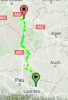
Stage 16: Albertville - Le Grand-Bornand, 196km

acc20n.png


10r8xkx.png


GPM:
Col de la Croix-Fry (cat.1) 12,9km @ 6,5%
Col des Glières (cat.1) 8,7km @ 8,2%
Col des Fleuries (cat.3) 5,5km @ 4,5%
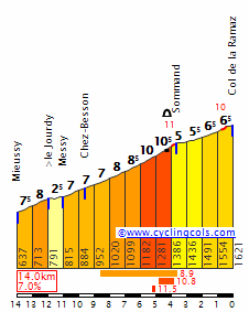
Col de la Ramaz (HC) 14,0km @ 7,0%
Col de Romme (cat.1) 9,6km @ 8,4%
Col de la Colombière (cat.1) 7,5km @ 8,5%

A complete cold open for the péloton now, as the first stage after the rest day is, well, the queen stage. It's also changed somewhat from the original design which finished not on the 2009 Romme-Colombière double but in Morzine after Joux-Plane and Joux-Verte, but since bp92's recent Tour included that same finish, I decided to shake things up. You may note some similarities between my stage and the queen stage of the 2009 Tour, since that stage was the one bright spot in an otherwise appalling Grand Tour, and quite possibly the finest piece of stage design Christian Prudhomme has ever greenlighted.

Albertville_in_Sav_3531498b.jpg


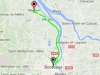
It is uncertain whether the second rest day will be better served in Grenoble, where stage 15 ends, or Albertville, where stage 16 begins. As the significantly larger city, Grenoble would seemingly make more sense, but Albertville is perfectly capable of hosting a rest day. Both cities are best known to the world as Winter Olympic hosts, with Albertville hosting much more recently (in 1992, the last Winter Olympiad to follow the same four year cycle as its summer counterpart). Experiencing rapid expansion during the Industrial Revolution, the city is surprisingly un-tourist-focused for a town buried within the Alps, although it serves as a base from which many resorts are accessed. It maintains relations with other urban centres within resort regions internationally as well, most notably Aosta and Poprad. As a sizable population centre within the Alps it unsurprisingly holds a lot of cycling history, hosting several stage starts and finishes in the Tour, the Dauphiné and the Tour de l'Avenir. Its most recent cycling history saw a hilly stage in the 2015 Dauphiné which was won by known culture vulture and women's rights activist Peter Kennaugh, regarded as one of the kindest and most tolerant men in the péloton (citation needed). More frequently, however, it serves as it does for me here, as the départ of a key mountain stage; its last appearance in the Tour was in 2012 in the short but tough La Toussuire stage, with Pierre Rolland arriving solo a minute ahead of Pinot, Jürgen VDB, Nibali and the Sky duo that controlled that race so effectively. The last time the Tour finished in Albertville was 1998, when Jan Ullrich won in this stage directly following the legendary Pantani exploits on the Galibier and to Les-Deux-Alpes.

la-croix-fry.jpg


The first climb of the day is actually uncategorized; it is nothing compared to what is to come, being mostly false flat, but the Col de Marais has a couple of steeper ramps. It was last seen in 2007, albeit from the easier northern side. This may be where the break begins to form, but it will be on the ensuing Col de la Croix-Fry that it really settles, as this tough ascent will ensure that the group is strong. From its hardest side, this climb was introduced to Le Tour in 1994, when it was mid-stage in a tough mountain stage from Moûtiers to Cluses; Piotr Ugrumov took the climb and the stage in an epic solo that set up his similarly monstrous subsequent TT win the next day. It returned mid-stage in 1997, with Jalabert first over the summit, before in both 2004 and 2013 it was used as the final climb of the day in stages to today's stage town of Le Grand-Bornand, with Floyd leading Lance over in 2004 en route to the latter's third consecutive stage win as the most dominant Lance of all twisted the knife on his competition, and in 2013 Rui Costa won from the break a couple of months before confirming himself among the pre-eminent riders in the world when he profited from Valverde taking a nap with a kilometre to go in Firenze to become World Champion.

Here, however, the climb won't be decisive as it crests just 40km into the stage. With a couple of steep kilometres its effect will be felt as the race continues, but for now we can descend into the skiing village of La Clusaz.

picture_366.jpg


This well-known ski town is the hometown of two great French skiers; the former Olympic champion Alpine skier Guy Périllat and the former World champion Nordic skier Vincent Vittoz. It shares the Aravis ski area with Le Grand-Bornand, and in fact as we descend past La Clusaz we pass just a couple of kilometres from the stage finish. Now, however, there's still much to do, and first on our list is to take on an as-yet-undiscovered-by-cycling beast, the savage Col des Glières.

http%3A%2F%2Fcoresites-cdn.factorymedia.com%2Frcuk%2Fwp-content%2Fuploads%2F2016%2F03%2FCol-de-Glieres-2-1020x765.jpeg


The Plateau des Glières is now best known as a cross-country skiing area, however its real claim to fame is as a key site of resistance fighting in World War II; the Maquis des Glières was a prominent guerrilla fighting group led by Tom Morel, that resisted the Nazi occupation at great length and whose struggles are commemorated in the Monument National de la Résistance des Glières, inaugurated in 1973. For cyclists, it was until recently an undiscovered and almighty steep monstrosity of a climb; while the western face of it has been discovered recently, with a 2013 Tour de l'Avenir stage finishing at the summit on the final day, with Julien Alaphilippe taking the stage but Rubén Fernández conserving his overall lead. While that side is far from easy (with 6,5km @ 9% in the middle), we're climbing the narrow eastern side, which is 8,7km @ 8,2% but with the middle 6km at no less than 11%; this will be really savage and though it may need a lick of asphalt, this should really be a 'eureka' kind of moment for ASO.

GlieresE.gif


annecy-ete-2012-plateau-des-glieres--8-.jpg


After descending the easier, wider side of Glières, the riders then have a fairly benign cat.3 climb at a consistent 4,5% to the Col des Fleuries. The break should really be down to its strongest riders now thanks to Glières, so there's now a period of recuperation and consolidation before the second part of the stage, where things should really get active. After passing through Mieussy, we take on the fifth and, get this, 
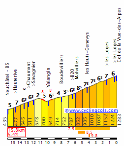
final HC mountain of the race, the mighty Col de la Ramaz. That's right - just five HC climbs:
- Col du Tourmalet
- Luz Ardiden
- Col du Mont-Noir
- Col Luitel
- Col de la Ramaz.
Now you start to see why I needed to go with some fairly generic, well-known climbs in my Pyrenean stage; the Alpine stages are more innovation and less treading the familiar grounds. In all reality the Col de la Ramaz is a tough call between cat.1 and HC, but I chose HC even though when the Tour has used the climb in the past they've erred on the side of cat.1.

4732689224_f12e899582.jpg


This desolate and spectacular climb is surprisingly unknown to the Tour considering how well it links to the popular climbs in the Morzine and Cluses areas. In fact, 2016 is the first time we'll see it chained with Joux-Plane, which was omitted in the two previous occasions the climb featured; first the 2003 Morzine stage which was won by Richard Virenque to enable him to take a day in yellow at the end of week 1 as the Alps were introduced, and then the 2010 Avoriaz stage with similar profile but an MTF; the climb served as the first real selective climb of the race and saw the final, terminal sinking of Lance Armstrong as a Tour contender. It's a tough one, less consistent than many similar-statistic climbs; don't be fooled. With 5km at 9% in the middle and some fluctuating ramps, this could be legitimately considered HC, especially considering some that get the categorization nowadays. The summit is just over 60km from the finish, so while I don't expect huge solo moves here, it is there as an option if anybody is up to it and desperate enough; if not it's a perfect opportunity to burn off some domestiques or test out your opponents' legs.

RamazW.gif


A long and complex descent with many technical turns and a short ramp in the middle then faces us as the riders head towards the intermediate sprint in Cluses; the last intermediate in Cluses was in the 2009 Tour and saw the remarkable breakaway of Thor Hushovd, solo over the Col des Aravis in order to pick up the six points for the maillot vert and safeguard his advantage over Cavendish. It's unlikely we'll see a repeat here.

Cluses-2.jpg


The last 40km are pure 2009 though. As mentioned, I think that the Le Grand Bornand stage of that race was the finest stage design Prudhomme ever agreed to; and here, even if Ramaz hasn't seen any action, we have a final 40km which almost certainly will force riders' hands because there are two back to back climbs with severe gradients and plenty of opportunity to make it count. No diesel grinding here. This is all finesse. The 
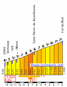
Col de Romme had never been seen in Le Tour until that 2009 stage where it broke the field apart after Carlos Sastre's last-ditch attempt, despite knowing his legs didn't have it, to defend his Tour crown. It hasn't been seen again since, bizarrely since, you know, the one stage that's used it was really, really good. And then it backs straight into the steepest, toughest part of the hardest side of the Tour classic that is the Col de la Colombière.

CPL_ROMME.jpg


The fact that Romme opens with 2km @ 11% tells us this is going to be violent, and cresting with 26km remaining there's little incentive not to make it count. Even if the riders are timid, there's little respite before the steepest part of the Col de la Colombière, a Tour classic introduced to the race in the 1960s, albeit until relatively recently almost invariably as a mid-stage threat and not a focal point.

DSCF0862.JPG


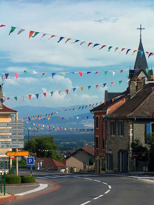
That all changed with the introduction of Le Grand-Bornand as a Tour de France stage town in 2004, however. While on the first occasion of a stage finish at the ski station, the riders came via the Col de la Croix-Fry, in 2007, it was the all-important focal point of the first mountain stage of the race. It was won by then-exciting prospect Linus Gerdemann on the same run-in that was repeated in 2009's stage posted above (won by Fränk Schleck), with the descent of the climb's more gradual side then a loop around town to finish on the Route de la Patinoire. The summit of the Col de la Colombière is less than 15km from the line, so there's very little excuse to be made for not making the most of this stage, especially as legs will be fresh after the rest day.

The finish is slightly different to how it looked last time the Tour was there, though. That's because, joy of joys, the city of Annecy in conjunction with the Haut-Savoie region funded the redevelopment and redesign of the existing skiing facilities around the town to set up something unique in the world of wintersport - a permanent temporary biathlon facility; the range is located on one side of the road with the stands opposing, and the actual road, with the finishing line that Schleck crossed, serves as the finishing line of the biathlon course, leaving the trails to loop around and even head into the village, creating a great carnival atmosphere although the trails aren't the toughest in the world. The French interest in biathlon is at a high point at the moment thanks to the success of multiple World and Olympic champion Martin Fourcade, an extremely boringly dominant champion who is every bit as humorous and happy-go-lucky off the trails as he is arrogant and tedious on them; his home region of Pyrenées-Orientales is somewhat out of the way for the World Cup so the French Alps were preferred for the reinstatement of a home round; the town of Le Grand-Bornand being the home of many great wintersports competitors over the years helped promote it as an option; I will draw some attention to the legendary Sylvie Becaert who, to me, is the town's most famous daughter. Here is one of the races from the first time the venue hosted the World Cup, in December 2013 (a previous attempt in December 2011 was aborted due to insufficient snowfall).

So yes, the queen stage. Only one HC climb, several cat.1s, and a continuation of one of the themes of this route, that being showing what could have been done with some of the poor Tour routes we've seen (1992 early on, 2009 here) by borrowing the one truly excellent thing about the 2009 Tour. I've managed to blend the old and the new, introduce some steep slopes, use some traditional homes of cycling, honour some French history and, of course, take an opportunity to shoe-horn some biathlon in there - surely here we have all the ingredients to keep both myself and the ASO happy?

grand_bornand_cp3348.jpg
 
Stage 17: Gex - La Chaux-de-Fonds, 189km

1ze9ys1.png


2s7ghma.png


GPM:
Côte de Saint-Georges (cat.2) 12,3km @ 4,0%
Côte de La Praz (cat.3) 5,2km @ 5,3%
Côte de Mauborget (cat.1) 10,5km @ 6,8%
Côte de Chaumont (cat.1) 9,9km @ 7,4%
La Vue-des-Alpes (cat.1) 10,1km @ 6,3%

Yes, that's right: only one Pyrenean mountain stage in my Tour, and only two Alpine stages, with no mountaintop finishes either. The toughest of mountain stages are over, but that's not to say there aren't opportunities for the climbers to come, they just need to work harder to take advantage of them as we've moved away from the Alps and into the Jura for a stage which takes place almost entirely on Swiss territory. In fact, we cross the border after just seven kilometres of racing, and never re-enter France on the day. This might seem odd, but we do see stages like this in the GTs, if not frequently then at least far from unprecedentedly. Take the 1992 Vuelta stage to Luz Ardiden which crossed to France over the first climb of the day and stayed there, or the 2009 Verbier stage which crossed almost immediately into Switzerland and stayed there. Perhaps the most extreme example is the forthcoming 2016 Vuelta stage to the Col d'Aubisque, which starts in a border town and crosses into France just 1km into the stage never to return; likewise the 2015 Vuelta a Castilla y León had a stage that was entirely in Portugal save for the final 900m. This will enable me to use some nice medium mountain and upper-medium mountain terrain known from the Tour de Romandie, which is far from my favourite World Tour race but does give some nice opportunities for the Tour to utilize some of its terrain without going the predictable route of producing a monster Valais stage or finishing at the rather tame Verbier. This was one of the toughest stages for me to decide on as a variety of options had been tried out based on the flow of stages, including a Mont-Noir MTF in a stage that was mostly in Switzerland but finished in France, a stage finishing after Le Chasseral, a stage to Pontarlier via Mauborget and Col de l'Aigüillon but with a tame final 30km, but eventually I settled on this.

96df20922407896e62edaedf52e76d26.jpg


The town of Gex has around 11.000 inhabitants and sits to the north of Geneva, close to the Swiss border in the Ain département. It is the main town of the Pays de Gex historic region, and has an enduring cycling connection as it sits at the southern edge of the Col de la Faucille, a historic climb - one of the most used in the Jura - which has been used more than 40 times in the Tour de France and still fulfils a role as one of the key climbs of the Tour de l'Ain. It was especially commonly-used in the interwar period, but was last seen in 2004 as a mid-stage climb in a week 3 transitional stage. We're not using the climb today, however, which is a rarity among Tour visits to Gex, although in fairness this would be its first time as a legit stage town.

Instead, we head across the border into Switzerland and ride along the lower edge of the Jura Vaudois, through Nyon before taking on our first climb of the day, the relatively long but uncomplicated Côte de Saint-Georges, which amounts to roughly the same as the first 15km of the southern side of the Col de Marchairuz. As you can see, a few kilometres at 5 or 6%, but nothing here is going to really cause difficulty and it's more about allowing a break of decent strength to go as I suspect this stage may be one that is best suited to the break as, though there's likely to be at least a bit of action behind, with no time bonuses and with tough stages preceding and succeeding it the first part of the stage may well be soft-pedalled by the maillot jaune's team. Then again, I thought that about Fuente Dé, so we'll see. The péloton will ride along the shoulder of Mont Tendre for a while before taking on a third category climb to the Côte de La Praz, a stop-off on the way to the better-known Col de Mollendruz, after which they will descend through the scenic Orbe into the more well-known Yverdon-les-Bains.

409922


From Yverdon-les-Bains we head around the north edge of the Lac de Neuchâtel in order to take on some of the neighbouring climbs. There are a few here; the toughest is the narrow, tricky Col de l'Aigüillon, the most well-known is the Col des Étroits that was used in the 2009 Verbier stage, but the climb I've chosen is the difficult-but-not-too-difficult Côte de Mauborget, a tricky climb into a beautiful mountain village on the way to Mont-Aubert which is very popular for hang-gliding owing to its brief plateau on an attractive rolling mountainside. We actually climb all of this profile but I'm putting the categorization points at the junction for Sainte-Croix, at the end of the 'real' climbing.

1098309_10151613776208915_175963273_n.jpg


The climb to Mauborget was in fact the decisive climb in the queen stage of the 2009 Tour de Romandie, which you can watch here; Roman Kreuziger, the eventual GC winner, outsprinted Rein Taaramäe from a two-up of sorts with Vlad Karpets just behind and Fredrik Kessiakoff following; behind, the rest of the elites came in at +51". This shows you the climb, although obviously it will be less decisive here as a mid-stage ascent before a rolling stretch and an uncategorized climb to Rougemonne before a long and tough descent that takes us back to the edges of Lake Neuchâtel, where we then ride along rolling terrain until we arrive in the city itself which hosts our intermediate sprint.

neuchatel-1.jpg


Neuchâtel last saw Le Tour in 1998, when Tom Steels won a sprint stage late in the race as they transitioned back toward Paris, but it has hosted its more local Tour, Romandie, three times since. In 2000 it was just a stage start, but it hosted a stage won by Vino in 2011, and the decisive ITT in 2014 which was won by Chris Froome by under a second ahead of Tony Martin, enabling the controversial Kenyan-born Briton with his spider-legs technique to overhaul Romandie specialist Simon Špilak on the final day to take the GC. Here, it will signal the end of the phony war and the beginning of the part of the stage that could prove relevant for the GC, because it's also the foot of the first of the two back-to-back climbs that end the stage, the Côte de Chaumont. With 3km @ 10% right in the middle this climb, which crests just inside 30km from the line, is a surprisingly little-heralded one, but trust me, it's tough. At just under 10km at 7,5% with some inconsistent ramps, this could surprise a few as it looks less threatening than it is, but it has some nice features, such as this waterfall and an observation tower that offers some spectacular views.

Aussichtsturm_Chaumont_Neuenburg.jpg


The descent of Chaumont's northern side is stupendously fast too; Andy Schleck would definitely have a complaint to make about it, as there are a couple of kilometres at no less than 12% - however these are almost ramrod straight with no technical challenges, so he can do one; the part of the descent with the twists and turns is much less fast and steep and on wider roads than at the top, so it shouldn't cause major difficulties.

And then, directly off the back of the descent, we have the final climb of the day. I don't really know why, but I really like the climb of La Vue-des-Alpes. It's not an especially difficult climb, around 10km at just over 6%, it's not at particularly high altitude, and it is fairly wide and doesn't provide a stiff technical challenge from the descent. It's lopsided with its southeastern face being much tougher than its northwestern counterpart, and although I've given it cat.1 status owing to its key position in the stage, in the Tour de Romandie the last time it was used it was only cat.2, in the 2015 Saint-Imier stage where the group was trimmed to under 50 but we still saw a reduced sprint which was unfortunately won by Michael Albasini, a rider known for his tolerance and civil rights activism (citation needed). I think a lot of the reason that I like it is the panorama; it has one of the best views from the summit of any climb, as looking south you can see over Chaumont to Lac Neuchâtel with the Alps rising from the Fribourgois lowlands to the south. The Tour de France has been to La Vue-des-Alpes, although it hasn't been back in nearly 40 years now. The first time was in the Lausanne-Mulhouse stage in 1948, when Gino Bartali was first over the summit, while he was wearing the maillot jaune and, because he's Gino Bartali and he's just that awesome, preventing civil war in Italy. The following year it returned in another stupendously long stage from Lausanne to Colmar, this time with Raphaël Géminiani winning the climb en route to a long escape that took him to the line. It was last seen in 1979, from its easier northern side, in the middle of a long transitional stage between the Vosges and the Alps; since then, the Tour has rather forgotten about the climb.

VueDesAlpesS.gif

(We're only doing the last 10,3km from Valangin, due to the inclusion of Chaumont)

17_vuedesalpes.jpg


The summit at La Vue-des-Alpes is wide and scenic and originally I thought about an MTF here, but instead I preferred a descent, not into Saint-Imier like in Romandie 2015, but a shorter descent into the historic city of La Chaux-de-Fonds. I have got tougher climbs preceding Vue-des-Alpes than in that Romandie stage, but also by bringing the stage finish closer to the summit it should give less opportunity for things to come back together. I do definitely think that unless some riders take some crazy risks on Chaumont or somebody's really having a bad day recovering from the Le Grand-Bornand stage we are likely to see the top few riders finish together in this stage, but nevertheless, this should be a frantic finish - plus, if the break takes it as I imagine they might, we could well see some fireworks for the stage win as many second-tier climbers or those whose GC has been disrupted could well want to salvage the race, I'm thinking a lot like the 2013 escapades of Rui Costa or the 2015 performances by Rubén Plaza. The Alaphilippes, Albasinis and Špilaks of the world are those who may well be in the running for this stage as well as those aforementioned, as well as, if their GC bids have fallen by the wayside, the likes of Zakarin.

The descent into La Chaux-de-Fonds is short and fairly straightforward, and the summit is just 8,4km from the line; I have a final 1200m loop around the city which includes a 200m ramp up a fairly steep but wide and totally straight road, then back down and then the final 700m is ramrod straight on a central thoroughfare. The city has been chosen as a finish owing to its historic nature; it is the most important watch-making city in Switzerland (which is saying something since the country is of course particularly famous for this purpose), and unique among Swiss cities in that it has been built on a North American-style grid system following the original city centre being destroyed by a fire in the 18th Century. Because of its dependence on a division of labour in the city's specialist industry and the way the grid system facilitated a fast transition from small specialist processes to large industrial concerns, it drew particular attention from Marx in Das Kapital as a "Stadtfabrik". Owing to its historic significance the city was awarded UNESCO World Heritage Site status. The city's most famous children are the architect known by his professional name Le Corbusier, and Louis Chevrolet, founder of the eponymous automotive firm, best known in the USA and now part of General Motors.

La Chaux-de-Fonds does have plenty of cycling history too, though. It hosted the Tour in 1998 as the start of the stage which followed the one to Neuchâtel mentioned above; the stage was the same one mentioned during stage 13 in fact - won by Magnus Bäckstedt from the break in Autun. Since then it has hosted its home race several times; Romandie passes through here regularly. Most recently, in fact, just a couple of months ago, as the 2016 edition began with a prologue through the town which was won by Ion Izagirre (depending on Movistar's GC ambitions, he may also be a contender for this stage actually). It last hosted a road stage in 2012, which was hilly but led to the almost absurd sight of Bradley Wiggins, in the midst of his T-1000 unbeatable phase, winning the stage in a sprint. No, really. This actually happened. If a GC man wins here today, however, it will likely be from a select group as mentioned before. This one isn't going to be easy but it simultaneously isn't a high mountain stage; it's more a transitional one, so it could be very open, however there are plenty of opportunities for riders whose form is not where it should be to lose out if fatigue is getting to them. The bookending of the race with mountain stages to prevent the usual "week 3 peak!" situation à la Ugrumov 1994 may start to play havoc with riders' form curves at this point, so this could be more intriguing than it looks, and if it isn't it should still be moderately selective, have an effect in the days to come, and produce a good fight from the break.

04_cdfll.jpg
 
Giro d'Italia stage 13: Firenze - Perugia (159 km)
8LGu9h0.png

wr7jVFL.jpg


Before the mountains start again, the sprinters get another chance...and this time it's really a stage for them.
The beginning of the stage is still in Firenze, and after a few kilometers the first climb of the day starts, a 4th category climb, which will make the beginning hard and will probably be crucial for the fight for the break. This short ascent is followed by a very long easy section which ends with an intermediate sprint in Arezzo, a town which has already hosted a few cycling races, for example a medium mountain stage in the Giro this year, which was won by Gianluca Brambilla.
arezzo_view_panoramica.JPG


After the intermediate sprint the hardest climb of the day starts, the Monte Lignano, which is a short but very steep climb which should hurt some sprinters but I doubt even Kittel would drop here. After a technical descent there is immediately the next intermediate sprint which is then followed by a very very long flat section which ends doesnt stop until the finish. But before the riders arrive there they ride around the very scenic Lago Trasimeno
1.jpg


The finish is located in Perugia, a typical italian town located on a hill. That also means that the finish will be slightly uphill, so although the stage was generally very easy the sprint will be very hard and difficult to win for sprinters like Kittel.
panorama%20perugia.jpg
 
Giro d'Italia stage 14: Perugia - Leonessa (234 km)
VoiiPie.png

sBZp0oi.jpg


After the sprinters had their chances the gc riders get into the center of attention again. The first 70 kilometer after the start in Perugia are still relatively flat, but from the beginning of the first climb on it's a steady up and down for the next 160 kilometers. The first two climbs are relatively easy, first a 4th category ascent to the little town Casteldelmonte, and after an intermediate sprint in Spoleto the Forca de Cero, a climb which was already part of cycling races a few times, the last time in a Tirreno stage 2014, which ended with a mtf to Cittareale Selvarotonda, which was won by Alberto Contador
It was also part of a Giro stage 2007, which ended in Spoleto, so the climb was ridden from the other side and in 2007 the penultimate climb was an ascent which in this stage is the next one, the Forca Capistrello. However while this climb is a 4th category climb from the other side, the way it is used in this stage, it is really difficult. It's an extremely irregular climb, with a few flat sections, even a short descent near the top but between those easy sections there are always rather long parts with some serious gradients, like a 6 kilometer section with an average gradient of almost 8%.
1997_altimetria-forca-di-capistrello.jpg

(Btw, I don't know what the guy who made this profile smoked, but 6.7% average gradient is complete nonsense. It's a little less than 6%, but thats due to the easy sections and really doesn't show the real difficulty of this climb)
If this was a tour de france climb it would surely be 1st category, but in the Giro it would probably only get 2nd cat., but it's hard to say and since I don't have too many 1st category climbs in the route and I still want to make the fight for the mountains jersey interesting I decided to give this ascent 1st category.
After the short descent the riders are actually only a few km away from the finish in Leonessa, but instead of finishing already the riders have to make a big loop around the famous Monte Terminillo, so they can climb it from its more difficult side later in the stage. This extra loop means that the 2nd most difficult climb of the stage will be rather far away from the finish which makes long range attacks less likely but it doesn't mean the time before the final climb starts will be easy. As I wrote earlier it's a steady up and down and the riders can never rest although there is only one categorized ascent between the descent from the Forca Capistrello and the start of the Monte Terminillo. And although there won't be a lot happening on those 50 kilometers the TV viewers can at least enjoy the guaranteed beautiful helicopter pictures of the region.
mti-reatini-mte-di-cambio-panorama-2-rcrlb.jpg


But then everyone should focus his attention on the race again because one of the hardest climb of the giro starts, the Monte Terminillo, or Sella di Leonessa. This is probably one of my favorite passes in italy since it is basically a climb which has the beautiful scenery of the alps, the brutal length of an alpine climb, and is also very steep, but it's located in the center of the country instead of being in the north. However although I love this pass, it's unfortunately difficult to use. In most cases there is a mtf in Terminillo, about 5 kilometers before the top of the pass, like in the giro 2010 or the Tirreno Adriatico 2015, when Quintana won on a snowy Monte Terminillo. But as you can see this is actually a pass and I never like it when such a hard pass is used as a mtf, so I wanted to descend it, but unfortunately there isn't really a place where you can finish after the descent. So you can put the pass in the middle of the stage like seen in the stage 2007 I mentioned before, or you could climb the pass from the other side and finish in Rieti, but unfortunately the climb is way easier if you start in Leonessa. So I decided to don't care about the size of the town and finish in Leonessa anyway and I honestly think it should be possible considering the tdf can finish in towns like Culoz.
Leonessa itself is a beautiful village mainly known for tourism, since it is located very close to the skiing area of the Monte Terminillo
21929950679_4eb394ee43_b.jpg


But now let's talk about the final climb again. The ascent is 21 kilometers long and has an average gradient of 6.6%, which means it has an altitude difference of 1400 meters. The gradients would be even higher if there wouldn't be 3 kilometer section of false flat near the end, so the climb is even harder than the numbers suggest.
Terminillo_dett.jpg


This is one of the last mountain stages of the race, and the last mountain stage of the week, since stage 15 will only be a medium mountain stage, so the riders definitely should attack here. They won't get much more difficult climbs in the last week so this is the point where they should go all out. The technical descent will give them another chance to attack, extend their lead or maybe to cut one's losses. And all this will be done in one of the most scenic roads in the country
dO0xDPW.jpg
 
Giro d'Italia stage 15: Spoleto - Macerata (221 km)
c7D50SZ.png

QILNw8F.jpg


I'll try to make the write ups a bit shorter from now on since I want to finish this giro as soon as possible, so I can start to design a route for the new race design challenge and I don't always have time to write for over an hour :eek:

After a mountain stage on stage 14 there is a medium mountain stage on stage 15 before the final rest day. The start is already familiar to the riders since they already rode through Spoleto yesterday, and even the first climb, the Forca di Cero, was already used on the last stage. After this 3rd category climb there are 3 more warm up climbs which are 3rd or 2nd category. These climbs are Rasenna (2nd cat.), Santuario di Macerate (3rd cat.) and Sassotetto (2nd cat.). After these 100 kilometers which are already very difficult the first domestiques might already have been dropped, and the legs might already start to hurt a bit considering on the pace.Here the only intermediate sprint of the stage in the beautiful city Sarnano takes place.
MG_1329.jpg


Then after those first 4 climbs, the hardest one of the day starts. I again called this climb Sassotetto, but it doesn't really have the same top as the last climb. This ascent isn't very long but extremely steep, with a long stretch of clearly over 10%. Again this should hurt some riders although the finish is still almost 100 kilometers away. And although there aren't many categorized climbs left, flat kilometers are still relatively rare and there are a few uncategorized climbs which will make the race hard.
Then the final of the stage starts with a two 3rd category climbs directly after each other.
Passo%255Edella%255ECappella%255Ee%255EMadonnella.jpg


You might think the brutal gradients you see here are the reason the final of this climb will be brutal but that profile still doesnt tell the whole story, however combined with this picture it does.
Z35gJpA.jpg


Yes we have sterrato in this stage, and it's probably one of the steepest gravel climbs in the whole country. Especially the Pitino Madonnella which has gradients of up to 20% will be brutal and so close to the finish the pace should be very high and gaps should definitely open up. There is a short flat section after the top of the 2nd climb, but this should be a great place to attack and you can loose a lot of time on such brutal gradients especially on gravel. Of course all that would be even more brutal in rain, but anyway it should be great to watch. Btw, I didn't find those two climbs on my own, they should have been used in the giro 2012 but the organizers then decided to only use the 2nd of the two climbs and in the stage the climbs were even more far away from the finish + we are talking about the giro 2012 so of course nothing happened there.
After the descent the climbing isn't just done yet, since after a section of slightly less than 10 kilometers of flat road the riders climb up to the city Macerata where the finish of the stage will be. Therefore even if there is still a group of a few riders together after the two gravel climbs there should be some time gaps.
vistamacerata.jpg


IMO the riders shouldn't hold anything back on the two sterato climbs since there is a rest day coming and there won't be any more brutal gradients than on this stage in the last week.
 

TRENDING THREADS