
Race Design Thread
Page 253 - Get up to date with the latest news, scores & standings from the Cycling News Community.
You are using an out of date browser. It may not display this or other websites correctly.
You should upgrade or use an alternative browser.
You should upgrade or use an alternative browser.
Re:
@mikii4567, i wonder if a collab would be in place as i think we have simillar ideas. How are you with central Europe (Poland, Chech Republic and Slovakia)? I won't help you much with Italy right now as i'm studying Moravia. From Lecce i only remember there was this architectonic style called barocco leccese. Also if your next stages are in puglia you'll probably stumble into this dude Frederick II a lot.
I mostly prefer a positive selection by just being better in a particular terrain rather than by crashing out of race. This time i will contradict myself, but this particular stage was haunting me for like 3 years now so i will finally get rid of it. Also i guess focus and bike handling skills are also part of this sport. Both 2 stages are in the Dordogne valley so expect deep ravines, plateaus, dense forests and narrow roads.
Last 3 stages: click
Tour de France by railxmig – stage 18. Les Eyzies-Cro Magnon - Montignac-Lascaux, 38km, ~435m asc.


Start: Les Eyzies-de-Tayac-Sireuil, Cro Magnon, Avenue de la Préhistoire
Finish: Montignac, Grotte de Lascaux 2, 530m, 7,5% uphill
Time Check 1: Tamniès, D48
Time Check 2: La Chapelle-Aubareil, Les Granges (max 7%)
Climbs:
Côte de la Castagnate - 2,1km, 6,8% (max 10%), 3 cat. 275m
Côte de Mondissou - 1km, 8,5% (max 12%), 4 cat. 228m
This is the 2nd TT. Categorisation of the climbs on this stage is more visual. I don't expect them to be categorised in an actual race. I'm more of a guy that in a TT would categorise only cat. 2 climbs or above. The main theme of this stage is prehistory.
This time trial starts in Cro Magnon, part of Les Eyzies-de-Tayac-Sireuil. Of course the whole area is full of various caves with prehistoric artifacts. I guess everybody knows something about this place so i will leave it here. This stage starts between Abri de Cro-Magnon and Musée national de Préhistoire on Avenue de la Préhistoire.


Start in Cro Magnon.

A shell necklace from Cro Magnon.
Most of this stage takes place in Perigord Noir – mainly on the Vézère valley. This valley is famous for very steep cliffs with various prehistoric caves dwelled in them. There are more of them than just Cro Magnon like nearby Abri du Poisson or Abri du Cap Blanc. The area is also known for walnuts, truffles and strawberries.

Vézère valley.
After first roughly 13km in La Beune valley the stage goes through various hills east of Vézère with Côte de la Castagnate, Côte de Mondissou and the ascent La Chapelle-Aubareil being the most prominent. These climbs are short but quite steep (max around 12% on Côte de Mondissou). The roads are mostly narrowish and quite twisty in mostly forests, but it shouldn't be a big problem for an ITT. I think the main difficulty may be the short but steep (max 10%) descent from Côte de Mondissou to Lascaux.

Descent from Côte de Mondissou.
Finish is near Grotte de Lascaux 2 on one of the nearby parking lots hidden in the dense forest. This finish is on a 530m at 7,5% hill. If i'm not mistaken this grotte is a sort of reproduction of the original one, which is some couple meters behind it. The original one was closed because it suffered from air and human breath.


Finish in Lascaux.

Lascaux.
Because of the hills and technical roads i assume some of the riders might fare much better than usual. Also Dordogne is known for unstable weather so it also should be an important factor. Besides all that, i don't think this stage should generate any big GC movements unless the weather is unstable.
The next stage will continue with the technical roads theme, but this time it will wander around the real Dordogne valley.
Tour de France by railxmig – stage 19. Brive-la-Gaillarde - Mauriac, 193km, ~2600m asc.


Start: Brive-la-Gaillarde, Promenade des Tilleuls, Place du 14 Juillet
Km 0: Brive-la-Gaillarde, Avenue Edmond Michelet, 2,6km from the start
Finish: Mauriac, Rue du 8 Mai, 230m straight
Sprint: Beaulieu-sur-Dordogne, Rue Général de Gaulle, 220m straight
Feed zone: Saint-Geniez-ô-Merle, le Vert
Climbs:
Côte de la Croix du Buis - 1km, 9,6%, 3 cat. 308m
Côte d'Auvergnassou - 8km, 4,4%, 3 cat. 497m
Le Puy Chastang - 7,3km, 3,7%, 3 cat. 558m
Côte de Riobazet - 2,1km, 5,4%, 4 cat. 313m
Côte de Freygnac - 5,8km, 5,3%, 3 cat. 540m
Côte du Breuil - 3,5km, 5,8%, 3 cat. 467m
Côte du Peuch - 7,6km, 4,2%, 3 cat. 582m
Côte de Montplaisir - 4,5km, 7% (max 12%), 2 cat. 583m
Start – km 0:
Promenade des Tilleuls - Avenue de Paris - Boulevard Général Koenig - Boulevard Edouard Lachaud - Boulevard Maréchal Lyautey - Avenue Edouard Herriot - Avenue Léon Blum - Avenue Edmond Michelet
Disclaimer: i'm not sure about the placement of km 0. It might be like 3-4km later so there's no initial bump and the action would start with a short run-in to the ascent to Noailles. The stage then should be around 190km long.
This stage is the oldest French stage i ever created. You could see a track4bikers profile of this one in my preview post. The last roughly 100km around Dordogne went unchanged since like June 2014.
It's the last stage before Paris and also the last stage which may feature some GC action. It will mainly depend on often unstable in this region weather. This stage also could be neutralised but i'm very cynical and potential crashes are part of this "fun". The main difficulty of this stage is to be 100% focused on your bike and your surroundings for the last roughly 120km. The first 75km to Goulles are rather easy and on wide roads.
This stage starts in one of the staples of Tour de France – Brive-la-Gaillarde. It's one of the biggest cities in Massif Central, behind only Clermont-Ferrand and Saint-Étienne. Last time Tour was in Brive-la-Gaillarde in 2012, where Mark Cavendish won a bunch sprint. The start is on Promenade des Tilleuls near Place du 14 Juillet.


Start in Brive-la-Gaillarde.

Aerial view of the centre of Brive-la-Gaillarde.
First 42km to Beaulieu-sur-Dordogne (where the intermediate sprint is located) are mainly to just get to Dordogne (i've also seen the naming variant with Dore). These opening kms are quite hilly but flat compared to the rest of this stage. There are also a couple of interesting towns like Meyssac or Collonges-la-Rouge with an interesting architecture based on red sandstones and various manor houses like Château du Martret or Château de Benge. The former abbey of Beaulieu-sur-Dordogne (IX c.) is also worth mentioning.

Collonges-la-Rouge.

Beaulieu-sur-Dordogne.
Riders will cross Dordogne for the first time in Beaulieu-sur-Dordogne. The Dordogne valley is very deep and densly forested. There are no particular mountain peaks nearby but mostly plateaus. The climbs are often steep at the bottom and flatter on the top. The roads are almost exclusively twisty and narrow. There's also a bunch of dams on the river and a couple of these will be visited today. From Beaulieu-sur-Dordogne riders will head into La Chapelle-Saint-Géraud and Goulles through Côte d'Auvergnassou.

Côte d'Auvergnassou from Beaulieu-sur-Dordogne.
In Goulles riders will wave goodbye to nice and wide roads as they'll descent down into Maronne valley (smaller sister of Dordogne valley) and Tours de Merle. Tours de Merle is a rather horrific looking desolate ruins of a castle from XII c. It's on a small hill overlooking river Maronne.

Vallée de la Maronne.

Tours de Merle.
Near Tours de Merle the 3rd climb of the day – Le Puy Chastang starts. On top of it there are roughly 15km of hilly terrain on a plateau (Saint-Geniez-ô-Merle), where a feed zone is also located. From there riders will go down to Dordogne once again crossing it in Argentat before going uphill first to Côte de Riobazet and then one of the hardest climbs of the day – Côte de Freygnac. Of course the roads are mostly narrowish and technically challenging.

Côte de Freygnac.

Road up to Côte de Freygnac.

Argentat.
From the top of Côte de Freygnac the next challenge is a descent down to Barrage Du Chastang (one of the dams on Dordogne), where Dordogne will be crossed for the 3rd time. After Barrage Du Chastang another climb awaits, to Servières-le-Château (Côte du Breuil).

Serpentine on the descent to Barrage Du Chastang.

Dordogne valley from Barrage Du Chastang.
From Servières-le-Château there will be around 10km of respite before going down once again to Dordogne, more exactly to Pont de Chambon and then uphill to Côte du Peuch and Saint-Merd-de-Lapleau, where a quite shallow descent to Laval-sur-Luzège starts. Laval-sur-Luzège is an interesting looking old village but now it's mostly deserted with just over 100 inhabitants. For the next roughly 10km to Barrage de l'Aigle (another dam on Dordogne) the stage goes alongside Dordogne. Here riders will cross the river for the 4th and final time.

A serpentine on a descent to Pont de Chambon.

Dordogne from Barrage de l'Aigle.
The last and hardest climb of the day starts just before Barrage de l'Aigle. It's Côte de Montplaisir and it goes up to Montplaisir, part of Chalvignac. It's 4,5km at 7% (max 12%) and it's the only climb on this stage worth cat. 2. The top of this climb is roughly 8km from the finish line. After the top however there's only a small plateau before the road (now wider) goes uphill once again (3-6%) to reach just over 700m in the outskirts of Mauriac. I expect some GC action on this climb unless everyone in GC is very spread out.

Côte de Montplaisir.
The run-in to Mauriac is, like most of this stage, quite difficult. First riders will go thorugh a short downhill section on Rue Saint-Mary and Boulevard Monthyon before a short uphill on Rue du 8 Mai to the finish line. Mauriac is nothing special – a former abbey, but it does have a small miracle in its history. It was a point of pilgrimage in the middle ages. The good times lasted until the French Revolution, when Mauriac fell into obscurity. The main sight is a basilica Notre-Dame-des-Miracles. Mauriac never hosted a Tour de France stage but it was a couple of times mid-stage.


Finish in Mauriac.

Notre-Dame-des-Miracles, Mauriac.
As i've mentioned before, the main difficulty of this stage are narrow and twisty roads going up and down the Dordogne valley. Most of the descents are unprotected and in dense forests. In real life such stage wouldn't have any rights to exist (but Mont du Chat... it might be interesting in the future). Here however it's the last significant stage of this Tour and any defect, technical or crash might be crucial as narrow roads should force the cars to go only one at a time. Yes, it's an awful way of selection but i guess the handling skills, rapid reactions and focus are also part of this sport.
For the last stage i decided to copy the 2015 Tour one.
Tour de France by railxmig – stage 20. Sèvres - Paris-Champs-Élysées, 110km.
To answer the potential 20 stages question. First stage was just a prologue. Stage 1 was actual stage 2 so stage 20 is 21. I probably screwed up the naming as i should count the prologue as a proper stage 1.
EDIT: Sorry, i missed this post.
1. Like Beille, Goulier-Neige is just lazy as almost everybody in this forum did it at least one in their lifetime and Beille is much tougher. But at least Beille seems to be not that liked here, and apparently i have some sort of a hipster in my blood.
2. Nobody will attack before Goulier-Neige, because most of them will be scared of that Llívia stage day after. That's why Beille should work better, because it will ensure some pain to the legs, even when softly taken while Goulier-Neige is just a regular cat. 1 climb. A really nice one, but i don't think it would work well with this specific scenario.
Goulier-Neige was very interesting a couple of years ago, but i've seen to many combinations with Latrape and Agnes while Beille doesn't seem to be very liked here. What i wanted to do is to have a finish on Monts-d'Olmes after Montségur but that would be too easy to handle as both climbs are nothing special and they're hardly linkable with anything. If it was like an introduction stage to Pyrenees then i would definitely go with Monts-d'Olmes as a leg warmer to much tougher couple of stages afterwards. Maybe i should go with Monts-d'Olmes and then start the next stage in Limoux, i will need to think on that once more. I hope i explained my thinking process well enough.
I kinda doubt it. Beille is here only to maybe have some impact on the Llívia stage, as on its own it's not that difficult. I assume any debris from dirt roads will be mostly cleared before the stage. Also there won't be any dirt sections if the weather is awful. I assume Beille will be taken softly ending in a 5-10-man group sprint. I also assume Alps are the main place for the climbers to do some damage. The 3rd week is more towards bike handlers. A lot of these guys can handle things like Paris-Roubaix or Strade Bianche pretty well so i guess a 7km of dirt roads is not that menacing.Guybrush said:railxmig, you killed 3/4 of the peloton with those stages :surprised:
@mikii4567, i wonder if a collab would be in place as i think we have simillar ideas. How are you with central Europe (Poland, Chech Republic and Slovakia)? I won't help you much with Italy right now as i'm studying Moravia. From Lecce i only remember there was this architectonic style called barocco leccese. Also if your next stages are in puglia you'll probably stumble into this dude Frederick II a lot.
I mostly prefer a positive selection by just being better in a particular terrain rather than by crashing out of race. This time i will contradict myself, but this particular stage was haunting me for like 3 years now so i will finally get rid of it. Also i guess focus and bike handling skills are also part of this sport. Both 2 stages are in the Dordogne valley so expect deep ravines, plateaus, dense forests and narrow roads.
Last 3 stages: click
Tour de France by railxmig – stage 18. Les Eyzies-Cro Magnon - Montignac-Lascaux, 38km, ~435m asc.
Start: Les Eyzies-de-Tayac-Sireuil, Cro Magnon, Avenue de la Préhistoire
Finish: Montignac, Grotte de Lascaux 2, 530m, 7,5% uphill
Time Check 1: Tamniès, D48
Time Check 2: La Chapelle-Aubareil, Les Granges (max 7%)
Climbs:
Côte de la Castagnate - 2,1km, 6,8% (max 10%), 3 cat. 275m
Côte de Mondissou - 1km, 8,5% (max 12%), 4 cat. 228m
This is the 2nd TT. Categorisation of the climbs on this stage is more visual. I don't expect them to be categorised in an actual race. I'm more of a guy that in a TT would categorise only cat. 2 climbs or above. The main theme of this stage is prehistory.
This time trial starts in Cro Magnon, part of Les Eyzies-de-Tayac-Sireuil. Of course the whole area is full of various caves with prehistoric artifacts. I guess everybody knows something about this place so i will leave it here. This stage starts between Abri de Cro-Magnon and Musée national de Préhistoire on Avenue de la Préhistoire.
Start in Cro Magnon.
A shell necklace from Cro Magnon.
Most of this stage takes place in Perigord Noir – mainly on the Vézère valley. This valley is famous for very steep cliffs with various prehistoric caves dwelled in them. There are more of them than just Cro Magnon like nearby Abri du Poisson or Abri du Cap Blanc. The area is also known for walnuts, truffles and strawberries.
Vézère valley.
After first roughly 13km in La Beune valley the stage goes through various hills east of Vézère with Côte de la Castagnate, Côte de Mondissou and the ascent La Chapelle-Aubareil being the most prominent. These climbs are short but quite steep (max around 12% on Côte de Mondissou). The roads are mostly narrowish and quite twisty in mostly forests, but it shouldn't be a big problem for an ITT. I think the main difficulty may be the short but steep (max 10%) descent from Côte de Mondissou to Lascaux.
Descent from Côte de Mondissou.
Finish is near Grotte de Lascaux 2 on one of the nearby parking lots hidden in the dense forest. This finish is on a 530m at 7,5% hill. If i'm not mistaken this grotte is a sort of reproduction of the original one, which is some couple meters behind it. The original one was closed because it suffered from air and human breath.
Finish in Lascaux.
Lascaux.
Because of the hills and technical roads i assume some of the riders might fare much better than usual. Also Dordogne is known for unstable weather so it also should be an important factor. Besides all that, i don't think this stage should generate any big GC movements unless the weather is unstable.
The next stage will continue with the technical roads theme, but this time it will wander around the real Dordogne valley.
Tour de France by railxmig – stage 19. Brive-la-Gaillarde - Mauriac, 193km, ~2600m asc.
Start: Brive-la-Gaillarde, Promenade des Tilleuls, Place du 14 Juillet
Km 0: Brive-la-Gaillarde, Avenue Edmond Michelet, 2,6km from the start
Finish: Mauriac, Rue du 8 Mai, 230m straight
Sprint: Beaulieu-sur-Dordogne, Rue Général de Gaulle, 220m straight
Feed zone: Saint-Geniez-ô-Merle, le Vert
Climbs:
Côte de la Croix du Buis - 1km, 9,6%, 3 cat. 308m
Côte d'Auvergnassou - 8km, 4,4%, 3 cat. 497m
Le Puy Chastang - 7,3km, 3,7%, 3 cat. 558m
Côte de Riobazet - 2,1km, 5,4%, 4 cat. 313m
Côte de Freygnac - 5,8km, 5,3%, 3 cat. 540m
Côte du Breuil - 3,5km, 5,8%, 3 cat. 467m
Côte du Peuch - 7,6km, 4,2%, 3 cat. 582m
Côte de Montplaisir - 4,5km, 7% (max 12%), 2 cat. 583m
Start – km 0:
Promenade des Tilleuls - Avenue de Paris - Boulevard Général Koenig - Boulevard Edouard Lachaud - Boulevard Maréchal Lyautey - Avenue Edouard Herriot - Avenue Léon Blum - Avenue Edmond Michelet
Disclaimer: i'm not sure about the placement of km 0. It might be like 3-4km later so there's no initial bump and the action would start with a short run-in to the ascent to Noailles. The stage then should be around 190km long.
This stage is the oldest French stage i ever created. You could see a track4bikers profile of this one in my preview post. The last roughly 100km around Dordogne went unchanged since like June 2014.
It's the last stage before Paris and also the last stage which may feature some GC action. It will mainly depend on often unstable in this region weather. This stage also could be neutralised but i'm very cynical and potential crashes are part of this "fun". The main difficulty of this stage is to be 100% focused on your bike and your surroundings for the last roughly 120km. The first 75km to Goulles are rather easy and on wide roads.
This stage starts in one of the staples of Tour de France – Brive-la-Gaillarde. It's one of the biggest cities in Massif Central, behind only Clermont-Ferrand and Saint-Étienne. Last time Tour was in Brive-la-Gaillarde in 2012, where Mark Cavendish won a bunch sprint. The start is on Promenade des Tilleuls near Place du 14 Juillet.
Start in Brive-la-Gaillarde.
Aerial view of the centre of Brive-la-Gaillarde.
First 42km to Beaulieu-sur-Dordogne (where the intermediate sprint is located) are mainly to just get to Dordogne (i've also seen the naming variant with Dore). These opening kms are quite hilly but flat compared to the rest of this stage. There are also a couple of interesting towns like Meyssac or Collonges-la-Rouge with an interesting architecture based on red sandstones and various manor houses like Château du Martret or Château de Benge. The former abbey of Beaulieu-sur-Dordogne (IX c.) is also worth mentioning.
Collonges-la-Rouge.
Beaulieu-sur-Dordogne.
Riders will cross Dordogne for the first time in Beaulieu-sur-Dordogne. The Dordogne valley is very deep and densly forested. There are no particular mountain peaks nearby but mostly plateaus. The climbs are often steep at the bottom and flatter on the top. The roads are almost exclusively twisty and narrow. There's also a bunch of dams on the river and a couple of these will be visited today. From Beaulieu-sur-Dordogne riders will head into La Chapelle-Saint-Géraud and Goulles through Côte d'Auvergnassou.
Côte d'Auvergnassou from Beaulieu-sur-Dordogne.
In Goulles riders will wave goodbye to nice and wide roads as they'll descent down into Maronne valley (smaller sister of Dordogne valley) and Tours de Merle. Tours de Merle is a rather horrific looking desolate ruins of a castle from XII c. It's on a small hill overlooking river Maronne.
Vallée de la Maronne.
Tours de Merle.
Near Tours de Merle the 3rd climb of the day – Le Puy Chastang starts. On top of it there are roughly 15km of hilly terrain on a plateau (Saint-Geniez-ô-Merle), where a feed zone is also located. From there riders will go down to Dordogne once again crossing it in Argentat before going uphill first to Côte de Riobazet and then one of the hardest climbs of the day – Côte de Freygnac. Of course the roads are mostly narrowish and technically challenging.
Côte de Freygnac.
Road up to Côte de Freygnac.
Argentat.
From the top of Côte de Freygnac the next challenge is a descent down to Barrage Du Chastang (one of the dams on Dordogne), where Dordogne will be crossed for the 3rd time. After Barrage Du Chastang another climb awaits, to Servières-le-Château (Côte du Breuil).
Serpentine on the descent to Barrage Du Chastang.
Dordogne valley from Barrage Du Chastang.
From Servières-le-Château there will be around 10km of respite before going down once again to Dordogne, more exactly to Pont de Chambon and then uphill to Côte du Peuch and Saint-Merd-de-Lapleau, where a quite shallow descent to Laval-sur-Luzège starts. Laval-sur-Luzège is an interesting looking old village but now it's mostly deserted with just over 100 inhabitants. For the next roughly 10km to Barrage de l'Aigle (another dam on Dordogne) the stage goes alongside Dordogne. Here riders will cross the river for the 4th and final time.
A serpentine on a descent to Pont de Chambon.
Dordogne from Barrage de l'Aigle.
The last and hardest climb of the day starts just before Barrage de l'Aigle. It's Côte de Montplaisir and it goes up to Montplaisir, part of Chalvignac. It's 4,5km at 7% (max 12%) and it's the only climb on this stage worth cat. 2. The top of this climb is roughly 8km from the finish line. After the top however there's only a small plateau before the road (now wider) goes uphill once again (3-6%) to reach just over 700m in the outskirts of Mauriac. I expect some GC action on this climb unless everyone in GC is very spread out.
Côte de Montplaisir.
The run-in to Mauriac is, like most of this stage, quite difficult. First riders will go thorugh a short downhill section on Rue Saint-Mary and Boulevard Monthyon before a short uphill on Rue du 8 Mai to the finish line. Mauriac is nothing special – a former abbey, but it does have a small miracle in its history. It was a point of pilgrimage in the middle ages. The good times lasted until the French Revolution, when Mauriac fell into obscurity. The main sight is a basilica Notre-Dame-des-Miracles. Mauriac never hosted a Tour de France stage but it was a couple of times mid-stage.
Finish in Mauriac.
Notre-Dame-des-Miracles, Mauriac.
As i've mentioned before, the main difficulty of this stage are narrow and twisty roads going up and down the Dordogne valley. Most of the descents are unprotected and in dense forests. In real life such stage wouldn't have any rights to exist (but Mont du Chat... it might be interesting in the future). Here however it's the last significant stage of this Tour and any defect, technical or crash might be crucial as narrow roads should force the cars to go only one at a time. Yes, it's an awful way of selection but i guess the handling skills, rapid reactions and focus are also part of this sport.
For the last stage i decided to copy the 2015 Tour one.
Tour de France by railxmig – stage 20. Sèvres - Paris-Champs-Élysées, 110km.
To answer the potential 20 stages question. First stage was just a prologue. Stage 1 was actual stage 2 so stage 20 is 21. I probably screwed up the naming as i should count the prologue as a proper stage 1.
EDIT: Sorry, i missed this post.
I decided against Goulier-Neige because:Forever The Best said:I don't like Plateau de Beille MTF that much in the last week of a GT, railxmig. Goulier-Neige is not that far away and suitable for attacks before the last climb. It would be a 1C climb:
And to not make the stage very short you canstart in Lannemezan and climb Mente before Portet d'Aspet and you have a stage like this:
https://www.la-flamme-rouge.eu/maps/viewtrack/hd/79132
The Llivia and Villeneuve sur Lot stages are very innovative, especially the first one and these stages after Goulier-Neige MTF can be perfect.
@fauniera Great stage with a nice murito finish. Very excited to have what you have next in store. But your images of Ermita de la Trinitat don't work because they are probably imgur.
1. Like Beille, Goulier-Neige is just lazy as almost everybody in this forum did it at least one in their lifetime and Beille is much tougher. But at least Beille seems to be not that liked here, and apparently i have some sort of a hipster in my blood.
2. Nobody will attack before Goulier-Neige, because most of them will be scared of that Llívia stage day after. That's why Beille should work better, because it will ensure some pain to the legs, even when softly taken while Goulier-Neige is just a regular cat. 1 climb. A really nice one, but i don't think it would work well with this specific scenario.
Goulier-Neige was very interesting a couple of years ago, but i've seen to many combinations with Latrape and Agnes while Beille doesn't seem to be very liked here. What i wanted to do is to have a finish on Monts-d'Olmes after Montségur but that would be too easy to handle as both climbs are nothing special and they're hardly linkable with anything. If it was like an introduction stage to Pyrenees then i would definitely go with Monts-d'Olmes as a leg warmer to much tougher couple of stages afterwards. Maybe i should go with Monts-d'Olmes and then start the next stage in Limoux, i will need to think on that once more. I hope i explained my thinking process well enough.
Re: Re:
I think i was too harsh on Goulier-Neige. It's not that i dislike this climb. I really like it as it's nicely linkable and it's a fine cat. 1 on its own, but i just don't want to use it because i consider it quite overused on this forum. I had my share of classic (for this thread) climbs and combos and i don't want to overstretch it by using another popular climb. Also, Beille is just a placeholder to justify the next stage in some way. There would be no attacks on either Beille or Neige because of the next stage, but Beille is much harder than Neige...
Tour de France by railxmig – ending post.
This Tour is weird. It heavily relies on weather as there are 3 potential echelon stages – Saint-Gilles-Croix-de-Vie, Saint-Pierre-d'Oléron and Le Cap d'Agde, and 4 other stages on which weather is important – Crozon-Perros-Trébéron, Llívia, Montignac-Lascaux and Mauriac. There are only 5 flat stages but max 7 stages should be for sprinters. There are 5 hilly stages of which 2 ends on a hill – Crozon-Perros-Trébéron and technically Manosque. 3 stages are medium mountain (one MTF), but Menthières-Monts Jura is a borderline mountain stage. All of them are potential GC important stages. 5 stages are mountain (3 MTFs).
There's a normal amount of MTF's i guess. There are 4 of them and outside of HC Plateau de Beille the hardest one is probably Aillons-Margériaz – a borderline cat. 1. Except cat. 4 Chalets des Marmottes rest of them are cat. 2.
The number of climbs cat. 2 or beyond isn't really big – 28. The number of HC climbs is rather normal – 6 of which 4 can be considered as crucial. One additional climb – Mont Revard can be considered as a borderline HC.
I normally prefer shorter stages, but this time i ended up with quite long ones. The shortest ones outside 3 TTs and Paris are Crozon-Perros-Trébéron and Aillons-Margériaz at almost 160km. There are 4 stages over 200km and also 5 over 190km to back it up. The longest stage is to Mâcon at 231km. The shortest one is the opening prologue in Brest.
First week relies mostly on flat and hilly stages, so it should be good for ruleurs. 2nd week should be the time, where climbers should launch their counterattack. 3rd week is very hilly and technical with twisty, narrow roads on occasionally rougher surface, so i guess it should be better for ruleurs but it's mostly for puncheurs and baroudeurs. I tried myself to not be concerned about the right distribution of stages and optimalization. It's just what i ended with. I don't care for whom it is or is it good. I personally kinda like this route.
Also a small trivia. There are roughly 12,5km of dirt roads in this race. It's a laughable amount for Strade Bianche or Tro-Bro Léon but i guess it should the the biggest amount of dirt Tour seen in decades.
Finally i'm done with this. If i will ever have any next projects it would be either short tours in more obscure places (i'm thinking about Moravia and Red Russia, Ukraine) or just one-day races. For now i'm quite done with GT's.
Stage, distance, type, difficulty:
Brest - Brest-Océanopolis, 6,4km,
 *
*
Brest-Spadiumparc - Crozon-Perros-Trébéron, 158km,
 (HTF + dirt) ***
Quimper - Plouay, 183km,
**
Vannes - Saint-Gilles-Croix-de-Vie, 190km,
 (wind) **
La Roche-sur-Yon - Saint-Pierre-d'Oléron, 190km,
(wind) **
Jonzac - Cognac, 41km,
*****
Guéret - Circuit de Nevers Magny-Cours, 170km,
*
Nevers - Mâcon, 231km,
*
Bourg-en-Bresse - Menthières-Monts Jura, 172km,
 (MTF) ***
-------
 Rest Day - Haute-Savoie-------
Annemasse - Aillons-Margériaz, 157km,
 (MTF) ****
Annecy - Saint-Jean-d'Arves-les Chalets des Marmottes, 185km,
(HTF) *****
Saint-Jean-de-Maurienne - Val-d'Isère, 224km,
*****
Vizille - Manosque, 194km,
(HTF) *
Châteaurenard - Le Cap d'Agde, 182km,
(wind) **
Béziers - La Salvetat-sur-Agout, 209km,
***
-------
Rest Day - Haute-Garonne-------
Saint-Gaudens - Plateau de Beille, 169km,
(MTF) *****
Foix - Llívia, 212km,
(dirt roads) *****
Muret - Villeneuve-sur-Lot, 199km,
*
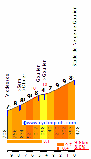
Les Eyzies-Cro Magnon - Montignac-Lascaux, 38km,
****
Brive-la-Gaillarde - Mauriac, 193km,
***
Sèvres - Paris-Champs-Élysées, 110km,
*
Statistics:
Flat Stages: 5
Hilly Stages: 5
Medium Mountain Stages: 3
Mountain Stages: 5
# of Categorized Climbs (Cat 2, 1, HC): 28
# of HC Climbs: 6
Summit Finishes: 4
Individual Time Trialing: 85km
Team Time Trial: 0km
Overall Distance: 3410km
Stage Avg: 162,3km
Stage Avg w/o TT: 184,7km
Started: 07.2014
Ended: 14.03.2017
Links:
Stages 1-3: click
Stages 4-6: click
Stages 7-8: click
Stages 9-10: click
Stages 11-12: click
Stages 13-14: click
Stage 15: click
Stages 16-18: click
Stages 19-21: click
Whole tour: click
Profiles:
Brest - Brest-Océanopolis:

Brest-Spadiumparc - Crozon-Perros-Trébéron:

Quimper - Plouay:

Vannes - Saint-Gilles-Croix-de-Vie:

La Roche-sur-Yon - Saint-Pierre-d'Oléron:

Jonzac - Cognac:

Guéret - Circuit de Nevers Magny-Cours:

Nevers - Mâcon:

Bourg-en-Bresse - Menthières-Monts Jura:

Annemasse - Aillons-Margériaz:

Annecy - Saint-Jean-d'Arves-les Chalets des Marmottes:

Saint-Jean-de-Maurienne - Val-d'Isère:

Vizille - Manosque:

Châteaurenard - Le Cap d'Agde:

Béziers - La Salvetat-sur-Agout:

Saint-Gaudens - Plateau de Beille:

Foix - Llívia:

Muret - Villeneuve-sur-Lot:

Les Eyzies-Cro Magnon - Montignac-Lascaux:
Brive-la-Gaillarde - Mauriac:
Sèvres - Paris-Champs-Élysées:
Champs-Élysées...
This tour might be updated in the future.
railxmig said:I decided against Goulier-Neige because:Forever The Best said:I don't like Plateau de Beille MTF that much in the last week of a GT, railxmig. Goulier-Neige is not that far away and suitable for attacks before the last climb. It would be a 1C climb:
And to not make the stage very short you canstart in Lannemezan and climb Mente before Portet d'Aspet and you have a stage like this:
https://www.la-flamme-rouge.eu/maps/viewtrack/hd/79132
The Llivia and Villeneuve sur Lot stages are very innovative, especially the first one and these stages after Goulier-Neige MTF can be perfect.
@fauniera Great stage with a nice murito finish. Very excited to have what you have next in store. But your images of Ermita de la Trinitat don't work because they are probably imgur.
1. Like Beille, Goulier-Neige is just lazy as almost everybody in this forum did it at least one in their lifetime and Beille is much tougher. But at least Beille seems to be not that liked here, and apparently i have some sort of a hipster in my blood.
2. Nobody will attack before Goulier-Neige, because most of them will be scared of that Llívia stage day after. That's why Beille should work better, because it will ensure some pain to the legs, even when softly taken while Goulier-Neige is just a regular cat. 1 climb. A really nice one, but i don't think it would work well with this specific scenario.
Goulier-Neige was very interesting a couple of years ago, but i've seen to many combinations with Latrape and Agnes while Beille doesn't seem to be very liked here. What i wanted to do is to have a finish on Monts-d'Olmes after Montségur but that would be too easy to handle as both climbs are nothing special and they're hardly linkable with anything. If it was like an introduction stage to Pyrenees then i would definitely go with Monts-d'Olmes as a leg warmer to much tougher couple of stages afterwards. Maybe i should go with Monts-d'Olmes and then start the next stage in Limoux, i will need to think on that once more. I hope i explained my thinking process well enough.
I think i was too harsh on Goulier-Neige. It's not that i dislike this climb. I really like it as it's nicely linkable and it's a fine cat. 1 on its own, but i just don't want to use it because i consider it quite overused on this forum. I had my share of classic (for this thread) climbs and combos and i don't want to overstretch it by using another popular climb. Also, Beille is just a placeholder to justify the next stage in some way. There would be no attacks on either Beille or Neige because of the next stage, but Beille is much harder than Neige...
Tour de France by railxmig – ending post.
This Tour is weird. It heavily relies on weather as there are 3 potential echelon stages – Saint-Gilles-Croix-de-Vie, Saint-Pierre-d'Oléron and Le Cap d'Agde, and 4 other stages on which weather is important – Crozon-Perros-Trébéron, Llívia, Montignac-Lascaux and Mauriac. There are only 5 flat stages but max 7 stages should be for sprinters. There are 5 hilly stages of which 2 ends on a hill – Crozon-Perros-Trébéron and technically Manosque. 3 stages are medium mountain (one MTF), but Menthières-Monts Jura is a borderline mountain stage. All of them are potential GC important stages. 5 stages are mountain (3 MTFs).
There's a normal amount of MTF's i guess. There are 4 of them and outside of HC Plateau de Beille the hardest one is probably Aillons-Margériaz – a borderline cat. 1. Except cat. 4 Chalets des Marmottes rest of them are cat. 2.
The number of climbs cat. 2 or beyond isn't really big – 28. The number of HC climbs is rather normal – 6 of which 4 can be considered as crucial. One additional climb – Mont Revard can be considered as a borderline HC.
I normally prefer shorter stages, but this time i ended up with quite long ones. The shortest ones outside 3 TTs and Paris are Crozon-Perros-Trébéron and Aillons-Margériaz at almost 160km. There are 4 stages over 200km and also 5 over 190km to back it up. The longest stage is to Mâcon at 231km. The shortest one is the opening prologue in Brest.
First week relies mostly on flat and hilly stages, so it should be good for ruleurs. 2nd week should be the time, where climbers should launch their counterattack. 3rd week is very hilly and technical with twisty, narrow roads on occasionally rougher surface, so i guess it should be better for ruleurs but it's mostly for puncheurs and baroudeurs. I tried myself to not be concerned about the right distribution of stages and optimalization. It's just what i ended with. I don't care for whom it is or is it good. I personally kinda like this route.
Also a small trivia. There are roughly 12,5km of dirt roads in this race. It's a laughable amount for Strade Bianche or Tro-Bro Léon but i guess it should the the biggest amount of dirt Tour seen in decades.
Finally i'm done with this. If i will ever have any next projects it would be either short tours in more obscure places (i'm thinking about Moravia and Red Russia, Ukraine) or just one-day races. For now i'm quite done with GT's.
Stage, distance, type, difficulty:
Brest - Brest-Océanopolis, 6,4km,
Brest-Spadiumparc - Crozon-Perros-Trébéron, 158km,
Quimper - Plouay, 183km,
Vannes - Saint-Gilles-Croix-de-Vie, 190km,
La Roche-sur-Yon - Saint-Pierre-d'Oléron, 190km,
Jonzac - Cognac, 41km,
Guéret - Circuit de Nevers Magny-Cours, 170km,
Nevers - Mâcon, 231km,
Bourg-en-Bresse - Menthières-Monts Jura, 172km,
-------
Annemasse - Aillons-Margériaz, 157km,
Annecy - Saint-Jean-d'Arves-les Chalets des Marmottes, 185km,
Saint-Jean-de-Maurienne - Val-d'Isère, 224km,
Vizille - Manosque, 194km,
Châteaurenard - Le Cap d'Agde, 182km,
Béziers - La Salvetat-sur-Agout, 209km,
-------
Saint-Gaudens - Plateau de Beille, 169km,
Foix - Llívia, 212km,
Muret - Villeneuve-sur-Lot, 199km,
Les Eyzies-Cro Magnon - Montignac-Lascaux, 38km,
Brive-la-Gaillarde - Mauriac, 193km,
Sèvres - Paris-Champs-Élysées, 110km,
Statistics:
Flat Stages: 5
Hilly Stages: 5
Medium Mountain Stages: 3
Mountain Stages: 5
# of Categorized Climbs (Cat 2, 1, HC): 28
# of HC Climbs: 6
Summit Finishes: 4
Individual Time Trialing: 85km
Team Time Trial: 0km
Overall Distance: 3410km
Stage Avg: 162,3km
Stage Avg w/o TT: 184,7km
Started: 07.2014
Ended: 14.03.2017
Links:
Stages 1-3: click
Stages 4-6: click
Stages 7-8: click
Stages 9-10: click
Stages 11-12: click
Stages 13-14: click
Stage 15: click
Stages 16-18: click
Stages 19-21: click
Whole tour: click
Profiles:
Brest - Brest-Océanopolis:
Brest-Spadiumparc - Crozon-Perros-Trébéron:
Quimper - Plouay:
Vannes - Saint-Gilles-Croix-de-Vie:
La Roche-sur-Yon - Saint-Pierre-d'Oléron:
Jonzac - Cognac:
Guéret - Circuit de Nevers Magny-Cours:
Nevers - Mâcon:
Bourg-en-Bresse - Menthières-Monts Jura:
Annemasse - Aillons-Margériaz:
Annecy - Saint-Jean-d'Arves-les Chalets des Marmottes:
Saint-Jean-de-Maurienne - Val-d'Isère:
Vizille - Manosque:
Châteaurenard - Le Cap d'Agde:
Béziers - La Salvetat-sur-Agout:
Saint-Gaudens - Plateau de Beille:
Foix - Llívia:
Muret - Villeneuve-sur-Lot:
Les Eyzies-Cro Magnon - Montignac-Lascaux:
Brive-la-Gaillarde - Mauriac:
Sèvres - Paris-Champs-Élysées:
Champs-Élysées...
This tour might be updated in the future.
- Apr 30, 2011
- 49,038
- 31,669
- 28,180
I don't really get why you think the Llívia stage is so frightening that it'd block the previous stage. It has two cat 1 climbs 110 and 40km out and a cat 2 in the finale.
In the Alpes on the other hand, you have some really proper mountain stages, and I'm not sure how much would happen on the first stage after the rest day, but we should see plenty of fireworks on CdF and Iseran.
In the Alpes on the other hand, you have some really proper mountain stages, and I'm not sure how much would happen on the first stage after the rest day, but we should see plenty of fireworks on CdF and Iseran.
- Apr 15, 2016
- 4,247
- 680
- 17,680
Re:
And for Llivia stage to work out, there have to be some very tired legs which can be ensued by the Goulier Neige stage with chances of 40 km of action. And, people like Quintana have to go all out in Goulier Neige stage because the remaining stages don't suit them.
Indeed, the Llivia stage is great but it definitely won't frighten the riders in the previous stage which means that attacks on Agnes are very much possible in Goulier Neige stage.Netserk said:I don't really get why you think the Llívia stage is so frightening that it'd block the previous stage. It has two cat 1 climbs 110 and 40km out and a cat 2 in the finale.
In the Alpes on the other hand, you have some really proper mountain stages, and I'm not sure how much would happen on the first stage after the rest day, but we should see plenty of fireworks on CdF and Iseran.
And for Llivia stage to work out, there have to be some very tired legs which can be ensued by the Goulier Neige stage with chances of 40 km of action. And, people like Quintana have to go all out in Goulier Neige stage because the remaining stages don't suit them.
@Netserk & @Forever The Best. I don't know how good climbers are on dirt. On Finestre it doesn't seem to have much of an impact but the entire stretch is at 7-9%. Maybe i've panicked too much. If you want, you can change Beille into Goulier-Neige. I still would prefer something else (less explored) though. i allready borrowed the Val d'Isère stage and i personally wouldn't call it as proper. Iseran isn't that difficult (slightly harder than Risoul) and while Mont-Cenis is massive, there are like 15km of flat between it and Iseran.
Wait a sec... Goulier-Neige? I thought of Guzet-Neige. Goulier-Neige doesn't have any space available and it seems to be largely abandoned. I do however have a small crush on Les Monts d'Olmes, even if it's too easy and not really linkable with anything other than Montségur.
Wait a sec... Goulier-Neige? I thought of Guzet-Neige. Goulier-Neige doesn't have any space available and it seems to be largely abandoned. I do however have a small crush on Les Monts d'Olmes, even if it's too easy and not really linkable with anything other than Montségur.
- Apr 15, 2016
- 4,247
- 680
- 17,680
The Iseran stage has also altitude as a big factor. And also there is a small climb between Mont Cenis and Iseran.railxmig said:@Netserk & @Forever The Best. I don't know how good climbers are on dirt. On Finestre it doesn't seem to have much of an impact but the entire stretch is at 7-9%. Maybe i've panicked too much. If you want, you can change Beille into Goulier-Neige. I still would prefer something else (less explored) though. i allready borrowed the Val d'Isère stage and i personally wouldn't call it as proper. Iseran isn't that difficult (slightly harder than Risoul) and while Mont-Cenis is massive, there are like 15km of flat between it and Iseran.
Wait a sec... Goulier-Neige? I thought of Guzet-Neige. Goulier-Neige doesn't have any space available and it seems to be largely abandoned. I do however have a small crush on Les Monts d'Olmes, even if it's too easy and not really linkable with anything other than Montségur.
I think Goulier Neige can host a Tour stage finish if places like Bola del Mundo can host Vuelta stage finishes.
- Apr 30, 2011
- 49,038
- 31,669
- 28,180
Plus the whole stage has a lot of vertical meters, not to mention that it comes as the third back-to-back mountain stage. In this design I think the stage is great as it is, but in a different Tour, it'd be great to have Tignes as the finish after Cenis-Iseran.
Vuelta is way smaller than Tour, but then i've abandoned the realism long time ago so i should not really care. Yes, the Iseran stage has a lot of over 2000m stretches, but nowadays most of the climbers and their lieutenants are used to high altitudes thanks to the training camps.Forever The Best said:The Iseran stage has also altitude as a big factor. And also there is a small climb between Mont Cenis and Iseran.railxmig said:@Netserk & @Forever The Best. I don't know how good climbers are on dirt. On Finestre it doesn't seem to have much of an impact but the entire stretch is at 7-9%. Maybe i've panicked too much. If you want, you can change Beille into Goulier-Neige. I still would prefer something else (less explored) though. i allready borrowed the Val d'Isère stage and i personally wouldn't call it as proper. Iseran isn't that difficult (slightly harder than Risoul) and while Mont-Cenis is massive, there are like 15km of flat between it and Iseran.
Wait a sec... Goulier-Neige? I thought of Guzet-Neige. Goulier-Neige doesn't have any space available and it seems to be largely abandoned. I do however have a small crush on Les Monts d'Olmes, even if it's too easy and not really linkable with anything other than Montségur.
I think Goulier Neige can host a Tour stage finish if places like Bola del Mundo can host Vuelta stage finishes.
I never was a person, who thought vertical meters really mattered that much. Yes, i also hope that, because it's 3rd back to back mountain stage it will generate bigger gaps than it usually could do. Also, Mont-Cenis & Iseran combo is obviously not my idea so i'm thanking to whoever came up with it first.Netserk said:Plus the whole stage has a lot of vertical meters, not to mention that it comes as the third back-to-back mountain stage. In this design I think the stage is great as it is, but in a different Tour, it'd be great to have Tignes as the finish after Cenis-Iseran.
- Apr 15, 2016
- 4,247
- 680
- 17,680
Re:
And I think there can be many ways for a last GC defining stage of the race(except TTs) can be long mountain stages(200-250 km) and have some hard passes in quick succession (Cyclotouristes-Arpettaz-Bisanne combo after 1 or 2 hard climbs, Sinne-Saint Martin-Turini combo after 2 hard climb(Cayolle-Valberg for example), or Sampeyre-Fauniera combo with 1 or 2 climbs before it) before the easier final climbs (Aravis, Castillon, Madonna del Colletto etc.) and descents in the last 30 km or so.(finishes in Le Grand Bornand,Menton, Borgo San Dalmazzo etc.)(also a lot of vertical meters)
Or a short mountain stages with steep, mid length(1C) passes(Romme-Colombiere, Glieres etc.) in the beginning and easier passes in final 25-30 km.
Or a 200-250 km hilly stage with many 2nd and 3rd category passes.(an uphill finish like Urkiola wouldn't be a problem here if the previous climb are hard and well connected with the final one.) (example: Massif Central, Cevennes, Vosges, Jura, Basque Country etc.)
Or a classics type stage in Ardennes hills, Flanders cobbled hills, Roubaix cobbles, ribin roads(Tro Bro Leon), or Strade Bianche roads.
railxmig's Llivia stage is great because there is a lot of terrain for attacking from the start of Col de la Llose till the end and the best of all, it won't prevent any attacks on the previous day.They can attack on Llose, the descent of Llose, or on the dirt road sections, one of which is a 2C climb.
Also I eagerly wait for the sterrato stages of fauniera in the Vuelta.
Indeed. Tignes after Cenis-Iseran combo would be great in a different Tour, but the stage is great in this design because of the reasons you mentioned.Netserk said:Plus the whole stage has a lot of vertical meters, not to mention that it comes as the third back-to-back mountain stage. In this design I think the stage is great as it is, but in a different Tour, it'd be great to have Tignes as the finish after Cenis-Iseran.
And I think there can be many ways for a last GC defining stage of the race(except TTs) can be long mountain stages(200-250 km) and have some hard passes in quick succession (Cyclotouristes-Arpettaz-Bisanne combo after 1 or 2 hard climbs, Sinne-Saint Martin-Turini combo after 2 hard climb(Cayolle-Valberg for example), or Sampeyre-Fauniera combo with 1 or 2 climbs before it) before the easier final climbs (Aravis, Castillon, Madonna del Colletto etc.) and descents in the last 30 km or so.(finishes in Le Grand Bornand,Menton, Borgo San Dalmazzo etc.)(also a lot of vertical meters)
Or a short mountain stages with steep, mid length(1C) passes(Romme-Colombiere, Glieres etc.) in the beginning and easier passes in final 25-30 km.
Or a 200-250 km hilly stage with many 2nd and 3rd category passes.(an uphill finish like Urkiola wouldn't be a problem here if the previous climb are hard and well connected with the final one.) (example: Massif Central, Cevennes, Vosges, Jura, Basque Country etc.)
Or a classics type stage in Ardennes hills, Flanders cobbled hills, Roubaix cobbles, ribin roads(Tro Bro Leon), or Strade Bianche roads.
railxmig's Llivia stage is great because there is a lot of terrain for attacking from the start of Col de la Llose till the end and the best of all, it won't prevent any attacks on the previous day.They can attack on Llose, the descent of Llose, or on the dirt road sections, one of which is a 2C climb.
Also I eagerly wait for the sterrato stages of fauniera in the Vuelta.
Re: Re:
I'm from Poland so I know a bit about where to look for tracks, but I'm not that great when it comes to history")
Giro d'Italia
Stage 2: Lecce -> Nardo (Ring)
198km
 Flat stage


I know this is a pretty lame GT stage 2, but I simply didn't want to completely underload it and also I sort of wanted to have SOMETHING happening on stage 1 GC wise. Start is in Lecce again, so no need for any more information. The riders head south, through Apulia, pass the very forced KOM (1.7km at 3.5%... I really wanted the blue jersey to go to SOMEONE after day 2, though - remember the ITT was also pan-flat) and then hit the Ionian Sea coastline, to which they'll stick to for the remainer of the day.
The first of the two Traguardi Volante is in Gallipoli, a town founded in the ancient times that now mostly relies on coastal tourism. The other, shortly after is in the 'finishing' town of Nardo, founded by the Messapi in 1000BC which currently produces an array of DOC wines. There is a cathedral here, built in 1000AD.
But although the finish is in 'Nardo', the riders will actually pass the city with 39.7km to go. And won't return. Instead, they'll head north-west, and finish on the Nardo Ring. What's so special about that? The final 12.7km are on the actual high-speed test track used to test out the newest creations by the finest sports car manufacturers. Since 2012, it's owned by Porsche. Although I know this adds nothing to the sporting side, it will surely be something interesting to see and, as far as I'm aware, hasn't been done (ie. finishing on an oval track).
Start: Lecce, Via Garibaldi (km 0 is on the SP1, near Merine)
Finish: Nardo Ring
Intermediate sprints: Gallipoli, Nardo
Feed zone: Torre Vado
Climbs:
Schillanti (4th Category, 155 m, 1.7 Km at 3.5%, Km 48.7)
railxmig said:@mikii4567, i wonder if a collab would be in place as i think we have simillar ideas. How are you with central Europe (Poland, Chech Republic and Slovakia)? I won't help you much with Italy right now as i'm studying Moravia. From Lecce i only remember there was this architectonic style called barocco leccese. Also if your next stages are in puglia you'll probably stumble into this dude Frederick II a lot.
I'm from Poland so I know a bit about where to look for tracks, but I'm not that great when it comes to history
Giro d'Italia
Stage 2: Lecce -> Nardo (Ring)
198km
I know this is a pretty lame GT stage 2, but I simply didn't want to completely underload it and also I sort of wanted to have SOMETHING happening on stage 1 GC wise. Start is in Lecce again, so no need for any more information. The riders head south, through Apulia, pass the very forced KOM (1.7km at 3.5%... I really wanted the blue jersey to go to SOMEONE after day 2, though - remember the ITT was also pan-flat) and then hit the Ionian Sea coastline, to which they'll stick to for the remainer of the day.
The first of the two Traguardi Volante is in Gallipoli, a town founded in the ancient times that now mostly relies on coastal tourism. The other, shortly after is in the 'finishing' town of Nardo, founded by the Messapi in 1000BC which currently produces an array of DOC wines. There is a cathedral here, built in 1000AD.
But although the finish is in 'Nardo', the riders will actually pass the city with 39.7km to go. And won't return. Instead, they'll head north-west, and finish on the Nardo Ring. What's so special about that? The final 12.7km are on the actual high-speed test track used to test out the newest creations by the finest sports car manufacturers. Since 2012, it's owned by Porsche. Although I know this adds nothing to the sporting side, it will surely be something interesting to see and, as far as I'm aware, hasn't been done (ie. finishing on an oval track).
Start: Lecce, Via Garibaldi (km 0 is on the SP1, near Merine)
Finish: Nardo Ring
Intermediate sprints: Gallipoli, Nardo
Feed zone: Torre Vado
Climbs:
Schillanti (4th Category, 155 m, 1.7 Km at 3.5%, Km 48.7)
Giro d'Italia
Stage 3: Brindisi -> Mottola
166km
 Hilly stage


The first stage that may have some sort of importance, after the ITT. Whilst it may not see any GC action, as there is an MTF coming up (!), it may see some interesting fighting in the breakaway, especially on the final climb.
The start is in Brindisi, still in Apulia but more north. Another Roman city, it has a large castle with massive square towers and another cathedral, this time constructed in the 11th-12th century. The riders head west, into the mainland, and cross it completely, hitting the west coast at the Traguardo Volante in Taranto. This is an important commercial and military port, and is known as the "Spartan City", as it was the only colony founded by Sparta.
From here, it gets a 'bit' more tough. There are three cat. 4 climbs in the mid-section of the stage, and also there is the second Traguardo Volante, in Martina Franca. This municipality has a beautiful stone old town, and prominent Baroque Gates. The final climb is 2.7km long and averages 8.2%, and brings us to the finish in Mottola, a town inhabited since prehistory, and important because of its location on a hill. The Gulf of Taranto can be clearly seen. The town's economy now relies mostly on agriculture and food production.
Like I said, not likely to be very decisive, but can deliver an interesting battle towards the end.
Start: Brindisi, Via Liberta (km 0 is on the SS7 Via Appia, near Sant'Elia)
Finish: Mottola, Via Carlo Goldoni
Intermediate sprints: Taranto, Martina Franca
Feed zone: San Simone
Climbs:
Comune di Martina Franca (4th Category, 400 m, 2.9 Km at 6.0%, Km 87.8)
San Simone (4th Category, 462 m, 5.9 Km at 3.5%, Km 105.4)
Palagianello (4th Category, 239 m, 3.2 Km at 5.1%, Km 157.3)
Mottola (3rd Category, 343 m, 2.7 Km at 8.2%, finish).
Stage 3: Brindisi -> Mottola
166km
The first stage that may have some sort of importance, after the ITT. Whilst it may not see any GC action, as there is an MTF coming up (!), it may see some interesting fighting in the breakaway, especially on the final climb.
The start is in Brindisi, still in Apulia but more north. Another Roman city, it has a large castle with massive square towers and another cathedral, this time constructed in the 11th-12th century. The riders head west, into the mainland, and cross it completely, hitting the west coast at the Traguardo Volante in Taranto. This is an important commercial and military port, and is known as the "Spartan City", as it was the only colony founded by Sparta.
From here, it gets a 'bit' more tough. There are three cat. 4 climbs in the mid-section of the stage, and also there is the second Traguardo Volante, in Martina Franca. This municipality has a beautiful stone old town, and prominent Baroque Gates. The final climb is 2.7km long and averages 8.2%, and brings us to the finish in Mottola, a town inhabited since prehistory, and important because of its location on a hill. The Gulf of Taranto can be clearly seen. The town's economy now relies mostly on agriculture and food production.
Like I said, not likely to be very decisive, but can deliver an interesting battle towards the end.
Start: Brindisi, Via Liberta (km 0 is on the SS7 Via Appia, near Sant'Elia)
Finish: Mottola, Via Carlo Goldoni
Intermediate sprints: Taranto, Martina Franca
Feed zone: San Simone
Climbs:
Comune di Martina Franca (4th Category, 400 m, 2.9 Km at 6.0%, Km 87.8)
San Simone (4th Category, 462 m, 5.9 Km at 3.5%, Km 105.4)
Palagianello (4th Category, 239 m, 3.2 Km at 5.1%, Km 157.3)
Mottola (3rd Category, 343 m, 2.7 Km at 8.2%, finish).
Re:
. When i was doing Giro i used the IGM maps to get the names, but it's more of an army map and it's very wonky to work with. Maybe someone else has better maps to work with. Click on "Immagini" (a photos icon) on the bottom panel and then double click on whatever map you want. For now i recommend IGM maps (250.000, 100.000 and 25.000 scale).
This Comune di Martina Franca hill seems to be in the middle of nowhere. There seems to be a masseria (farm) nearby called Franzullo if i'm looking in the right place.
Interesting choice of finish. I would personally choose Matera as HTF and the stage wouldn't need to loop around so much but i guess it wouldn't work with the next stage. Also, Comune di Martina Franca is an interesting name for a climbmikii4567 said:Giro d'Italia
Stage 3: Brindisi -> Mottola
166km
Hilly stage
The first stage that may have some sort of importance, after the ITT. Whilst it may not see any GC action, as there is an MTF coming up (!), it may see some interesting fighting in the breakaway, especially on the final climb.
The start is in Brindisi, still in Apulia but more north. Another Roman city, it has a large castle with massive square towers and another cathedral, this time constructed in the 11th-12th century. The riders head west, into the mainland, and cross it completely, hitting the west coast at the Traguardo Volante in Taranto. This is an important commercial and military port, and is known as the "Spartan City", as it was the only colony founded by Sparta.
From here, it gets a 'bit' more tough. There are three cat. 4 climbs in the mid-section of the stage, and also there is the second Traguardo Volante, in Martina Franca. This municipality has a beautiful stone old town, and prominent Baroque Gates. The final climb is 2.7km long and averages 8.2%, and brings us to the finish in Mottola, a town inhabited since prehistory, and important because of its location on a hill. The Gulf of Taranto can be clearly seen. The town's economy now relies mostly on agriculture and food production.
Like I said, not likely to be very decisive, but can deliver an interesting battle towards the end.
Start: Brindisi, Via Liberta (km 0 is on the SS7 Via Appia, near Sant'Elia)
Finish: Mottola, Via Carlo Goldoni
Intermediate sprints: Taranto, Martina Franca
Feed zone: San Simone
Climbs:
Comune di Martina Franca (4th Category, 400 m, 2.9 Km at 6.0%, Km 87.8)
San Simone (4th Category, 462 m, 5.9 Km at 3.5%, Km 105.4)
Palagianello (4th Category, 239 m, 3.2 Km at 5.1%, Km 157.3)
Mottola (3rd Category, 343 m, 2.7 Km at 8.2%, finish).
. When i was doing Giro i used the IGM maps to get the names, but it's more of an army map and it's very wonky to work with. Maybe someone else has better maps to work with. Click on "Immagini" (a photos icon) on the bottom panel and then double click on whatever map you want. For now i recommend IGM maps (250.000, 100.000 and 25.000 scale).This Comune di Martina Franca hill seems to be in the middle of nowhere. There seems to be a masseria (farm) nearby called Franzullo if i'm looking in the right place.
Re: Re:
I just went by the name of the comune, I know that that's been done in the past by some race organisers.
Giro d'Italia
Stage 4: Massafra -> Monte Sirino
182km
 Medium-mountain stage


The first MTF of the race. Although Monte Sirino is not the hardest of climbs, it's still a pretty interesting MTF that may see the field being split a bit. I mostly envision that this stage could be similar to Roccaraso of this year - breakaway win, and GC favourites having their 'battle' behind. Oh, and BTW, this climb was used most recently in the 90s, with three stage finishes.
We start in Massafra, still in Apulia. A town founded by refugees in the 5th century, it has a castle from 970 and a 16th century church. The riders head south, towards the coast, and follow it 50km or so. After they turn inland, we begin to get some action. There's an intermediate sprint in Caprarico first, followed by the feed zone, before the first cat. 2 climb of the Giro. Tempa Rossa is a climb that is 6.2km long and averages 7.2%, so it's likely to be at least slightly selective and it must reduce the peloton. After that there is a cat. 3 climb, the short and shallow Armento, 20kms or so of flat, the second sprint in Grumento Nova and then the second cat. 3 climb, Moliterno. Then we get onto the finish climb; Sirino. The hardest climb of the day; 11.0 Km at 7.3%. Got to see some action on it, don't we?
Tappa Jalabert
In my Giro, I'm commemorating some famous riders' victories at the Giro, or simply some of the best known produces that Italy has. This stage commemorates the Frenchman, Laurent Jalabert. Whilst his palmares mostly consists of Tour and Vuelta victories - two points jerseys and two mountain jerseys at the Tour and an overall win in the 1995 Vuelta, he did actually take part in the Giro twice, in 1992 and 1999. He didn't complete his first Giro, but in 1999, he won stage 4 of the race, from Vibo Valentia to Terme Luigiane. On the next stage, he and Pantani worked furiously to bring back a select GC group whilst racing to the MTF in Sirino. They succeeded, and Jalabert got to wear his Maglia Rosa, which set him up for a good GC position at the end of the race - ultimately, he finished 4th.
Start: Massafra, Via Brindisi (km 0 is on the SP35, near Elena Marina)
Finish: Monte Sirino, Lago Laudemio
Intermediate sprints: Caprarico, Grumento Nova
Feed zone: Alianetto di Sotto
Climbs:
Tempa Rossa (2nd Category, 785 m, 6.4 Km at 7.2%, Km 110.2)
Armento (3rd Category, 973 m, 3.3 Km at 5.3%, Km 131.1)
Moliterno (3rd Category, 831 m, 3.4 Km at 6.6%, Km 161.9)
Monte Sirino (2nd Category, 1546 m, 11.0 Km at 7.3%, finish)

railxmig said:This Comune di Martina Franca hill seems to be in the middle of nowhere. There seems to be a masseria (farm) nearby called Franzullo if i'm looking in the right place.
I just went by the name of the comune, I know that that's been done in the past by some race organisers.
Giro d'Italia
Stage 4: Massafra -> Monte Sirino
182km
The first MTF of the race. Although Monte Sirino is not the hardest of climbs, it's still a pretty interesting MTF that may see the field being split a bit. I mostly envision that this stage could be similar to Roccaraso of this year - breakaway win, and GC favourites having their 'battle' behind. Oh, and BTW, this climb was used most recently in the 90s, with three stage finishes.
We start in Massafra, still in Apulia. A town founded by refugees in the 5th century, it has a castle from 970 and a 16th century church. The riders head south, towards the coast, and follow it 50km or so. After they turn inland, we begin to get some action. There's an intermediate sprint in Caprarico first, followed by the feed zone, before the first cat. 2 climb of the Giro. Tempa Rossa is a climb that is 6.2km long and averages 7.2%, so it's likely to be at least slightly selective and it must reduce the peloton. After that there is a cat. 3 climb, the short and shallow Armento, 20kms or so of flat, the second sprint in Grumento Nova and then the second cat. 3 climb, Moliterno. Then we get onto the finish climb; Sirino. The hardest climb of the day; 11.0 Km at 7.3%. Got to see some action on it, don't we?
Tappa Jalabert
In my Giro, I'm commemorating some famous riders' victories at the Giro, or simply some of the best known produces that Italy has. This stage commemorates the Frenchman, Laurent Jalabert. Whilst his palmares mostly consists of Tour and Vuelta victories - two points jerseys and two mountain jerseys at the Tour and an overall win in the 1995 Vuelta, he did actually take part in the Giro twice, in 1992 and 1999. He didn't complete his first Giro, but in 1999, he won stage 4 of the race, from Vibo Valentia to Terme Luigiane. On the next stage, he and Pantani worked furiously to bring back a select GC group whilst racing to the MTF in Sirino. They succeeded, and Jalabert got to wear his Maglia Rosa, which set him up for a good GC position at the end of the race - ultimately, he finished 4th.
Start: Massafra, Via Brindisi (km 0 is on the SP35, near Elena Marina)
Finish: Monte Sirino, Lago Laudemio
Intermediate sprints: Caprarico, Grumento Nova
Feed zone: Alianetto di Sotto
Climbs:
Tempa Rossa (2nd Category, 785 m, 6.4 Km at 7.2%, Km 110.2)
Armento (3rd Category, 973 m, 3.3 Km at 5.3%, Km 131.1)
Moliterno (3rd Category, 831 m, 3.4 Km at 6.6%, Km 161.9)
Monte Sirino (2nd Category, 1546 m, 11.0 Km at 7.3%, finish)
- Apr 15, 2016
- 4,247
- 680
- 17,680
Great to see Monte Sirino. And there will probably be some good gaps on the final climb. And the climb is harder than Roccaraso so it should do more damage if a rider isn't on form early in the race.
Giro d'Italia
Stage 5: Brienza -> Benevento
217km
Medium-mountain stage


The third hilly/medium-mountain stage in a row, this time not a HTF/MTF, but nonetheless still likely to be an interesting challenge for the breakaway. The start is in Brienza, known for being the home of the ruins of Caracciolo’s Castle. After the start, there is a long descent and then the cat. 3 climb of Caggiano, followed by a descent and false flat, before the cat. 3 Scorzo climb. After this, there's a flat section, with the two intermediate sprints, in Eboli and Battapaglia. We then have a cat. 4 climb before the difficulties of the day. The cat. 2 climb of Valico della Carbonara isn't particularly steep, at 5.3%, but is nonetheless 14.4km long. After this we have Monte Terminio, which is also 14.4km, but is even less steep, at 4.8%. So whilst these climbs aren't going to be very selective, they can nonetheless present an interesting challenge, and tire some legs.
The descent is broken in half by a cat. 4 climb, and then we have cat. 3 - Montefredane. Again, not too testing. The final climb is also cat. 3 - Colle di Campore. 5.2% means that once again we're not going steeply uphill, but can still challenge some. The finish is in Benevento, a Roman city with an 8th century Church (Santa Sofia). We've seen an end there in 2016, won by Greipel, but there the stage was almost completely flat. Maybe an interesting challenge for a breakaway, and a rest for the GC favourites.
Start: Brienza, SS95 (km 0 is on the SS95)
Finish: Benevento, Corso Garibaldi
Intermediate sprints: Eboli, Battapaglia
Feed zone: Maggese, (ommited from the profile by accident, but it would be after the Carbonara descent)
Climbs:
Caggiano (3rd Category, 802 m, 4.8 Km at 7.7%, Km 19.7)
Scorzo (3rd Category, 463 m, 2.3 Km at 8.7%, Km 44.9)
Montecorvino Rovella (4th Category, 305 m, 1.8 Km at 5.6%, Km 86.7)
Valico della Carbonara (2nd Category, 967 m, 14.4 Km at 5.3%, Km 106.7)
Monte Terminio (2nd Category, 1248 m, 14.4 Km at 4.8%, Km 132.4)
Sorbo Serpico (4th Category, 775 m, 1.3 Km at 4.5%, Km 156.1)
Montefredane (3rd Category, 602 m, 6.4 Km at 4.9%, Km 175.8)
Colle di Campore (3rd Category, 714 m, 10.2 Km at 5.2%, Km 197.7)
Stage 5: Brienza -> Benevento
217km
The third hilly/medium-mountain stage in a row, this time not a HTF/MTF, but nonetheless still likely to be an interesting challenge for the breakaway. The start is in Brienza, known for being the home of the ruins of Caracciolo’s Castle. After the start, there is a long descent and then the cat. 3 climb of Caggiano, followed by a descent and false flat, before the cat. 3 Scorzo climb. After this, there's a flat section, with the two intermediate sprints, in Eboli and Battapaglia. We then have a cat. 4 climb before the difficulties of the day. The cat. 2 climb of Valico della Carbonara isn't particularly steep, at 5.3%, but is nonetheless 14.4km long. After this we have Monte Terminio, which is also 14.4km, but is even less steep, at 4.8%. So whilst these climbs aren't going to be very selective, they can nonetheless present an interesting challenge, and tire some legs.
The descent is broken in half by a cat. 4 climb, and then we have cat. 3 - Montefredane. Again, not too testing. The final climb is also cat. 3 - Colle di Campore. 5.2% means that once again we're not going steeply uphill, but can still challenge some. The finish is in Benevento, a Roman city with an 8th century Church (Santa Sofia). We've seen an end there in 2016, won by Greipel, but there the stage was almost completely flat. Maybe an interesting challenge for a breakaway, and a rest for the GC favourites.
Start: Brienza, SS95 (km 0 is on the SS95)
Finish: Benevento, Corso Garibaldi
Intermediate sprints: Eboli, Battapaglia
Feed zone: Maggese, (ommited from the profile by accident, but it would be after the Carbonara descent)
Climbs:
Caggiano (3rd Category, 802 m, 4.8 Km at 7.7%, Km 19.7)
Scorzo (3rd Category, 463 m, 2.3 Km at 8.7%, Km 44.9)
Montecorvino Rovella (4th Category, 305 m, 1.8 Km at 5.6%, Km 86.7)
Valico della Carbonara (2nd Category, 967 m, 14.4 Km at 5.3%, Km 106.7)
Monte Terminio (2nd Category, 1248 m, 14.4 Km at 4.8%, Km 132.4)
Sorbo Serpico (4th Category, 775 m, 1.3 Km at 4.5%, Km 156.1)
Montefredane (3rd Category, 602 m, 6.4 Km at 4.9%, Km 175.8)
Colle di Campore (3rd Category, 714 m, 10.2 Km at 5.2%, Km 197.7)
Giro d'Italia
Stage 6: Benevento -> Frosinone
174km
Flat stage


The second flat stage of this Giro, and the second opportunity for the sprinters. With no categorised climbs, this will be their last opportunity for quite a long time.
The start is in Benevento, where we finished yesterday. The riders will head north-west, passing the city of Telese, an spa town after 26 km, where we will see the first Traguardo Volante. The second will be in Cassino, at the foothill of the summit known for an important battle during WWII and for its abbey built on a hilltop. The line, meanwhile, is drawn in Frosinone, a city which has frequently been destroyed and rebuilt in the past. It rapidly grew in the 17th century and was a known agricultural centre for this part of Italy. Today, though, it mostly focuses on industry and activities in the tertiary business sector.
Start: Benevento, Corso Garibaldi (km 0 is on the SS372)
Finish: Frosinone, SR156
Intermediate sprints: Telese, Cassino
Feed zone: Mignano Monte Lungo
Stage 6: Benevento -> Frosinone
174km
The second flat stage of this Giro, and the second opportunity for the sprinters. With no categorised climbs, this will be their last opportunity for quite a long time.
The start is in Benevento, where we finished yesterday. The riders will head north-west, passing the city of Telese, an spa town after 26 km, where we will see the first Traguardo Volante. The second will be in Cassino, at the foothill of the summit known for an important battle during WWII and for its abbey built on a hilltop. The line, meanwhile, is drawn in Frosinone, a city which has frequently been destroyed and rebuilt in the past. It rapidly grew in the 17th century and was a known agricultural centre for this part of Italy. Today, though, it mostly focuses on industry and activities in the tertiary business sector.
Start: Benevento, Corso Garibaldi (km 0 is on the SS372)
Finish: Frosinone, SR156
Intermediate sprints: Telese, Cassino
Feed zone: Mignano Monte Lungo
- Oct 12, 2013
- 2,430
- 31
- 6,530
VUELTA A ESPANA
(Thu) stage 17: Reus - Benicàssim, 177 km


Further south it goes; we are leaving Catalunya and enter Comunitat Valenciana. The stage is flat but includes two sharp little climbs in the final 10 km, which should make for interesting racing.


The first hill is 0,9 km at 9,8%.

descent:

The second hill is 0,7 km at 10%.


Reus

Benicàssim

(Thu) stage 17: Reus - Benicàssim, 177 km
Further south it goes; we are leaving Catalunya and enter Comunitat Valenciana. The stage is flat but includes two sharp little climbs in the final 10 km, which should make for interesting racing.
The first hill is 0,9 km at 9,8%.
descent:
The second hill is 0,7 km at 10%.
Reus
Benicàssim
Re:
Your next post suggests a rather busy couple of days so i guess such a breakaway stage should be fine. If someone wants to combine breakaway action with maybe some minor GC skirmishes and doesn't care about route realism (even if Giro doesn't shy from narrow roads) this particular person might try something like this:
Stage 5: Brienza -> Benevento

I've slightly changed the last two climbs. First one i just copied from my own stage to Salerno with a short but steep (around 10-15%) ramp on Via Cupali in Prata di Principato Ultra. It would result in roughly 10km more of transition from Sorbo Serpico. The last climb is more interesting however as there is a narrow but very steep alternative ramp to the village of Chianchetelle. It's roughly 1,3km at over 15% with max definitely over 20%. The last 200m in the village are on cobbles. I think this ramp could justify upgrading the whole climb to cat. 2. However, this ramp would be roughly 25km from the finish line, so i don't expect any GC changes unless someone is in bad form.

Montefredane from Prata di Principato Ultra.

Chianchetelle, first 1,3km of Colle di Campore.

Road up to Chianchetelle.
I was also playing around the north Spain a bit to maybe finally find something not presented previously by Libertine Seguros. This is probably my best shot. While the road to Vidángoz (called Carretera) is probably unsuitable unless heavilly cleaned up the last two dirt sections seems to be in fine condition.
Oloron-Sainte-Marie - Monasterio de Leyre, 204km

Apparently my Llivia stage was received relatively well. This time however it's much tougher with two ESP (HC) climbs Soudet and Larrau to shake off the bulkier guys to mostly leave i assume less suitable for rough surfaces guys in the peloton. While both ESP climbs are tough Vidángoz has over 20% sections with 1km at over 15%.

Vidángoz.
So this is some sort of a homage to my own Llivia stage from Tour de France and the Pampeluna '96 stage. All of the roads exept Vidángoz seems to be rideable. Also, this stage can finish either in the monastery or in Javier if you don't want any MTFs.

Road up to Vidángoz.

Dirt section near Sangüesa.

Dirt section near Javier.
I'm not planning on doing a Vuelta as there are plenty of them around. This is only a lone stage. You can combine it with an MTF day before in either Formigal (easier option), Gourette/Abisque (tougher version) or Issarbe (LS option). Last kms from Lumbier can also work well as part of a medium mountain stage in Novarra or some kind of a Pampeluna one-day race as it's not far from the city.
mikii4567 said:Giro d'Italia
Stage 5: Brienza -> Benevento
217km
Medium-mountain stage
The third hilly/medium-mountain stage in a row, this time not a HTF/MTF, but nonetheless still likely to be an interesting challenge for the breakaway. The start is in Brienza, known for being the home of the ruins of Caracciolo’s Castle. After the start, there is a long descent and then the cat. 3 climb of Caggiano, followed by a descent and false flat, before the cat. 3 Scorzo climb. After this, there's a flat section, with the two intermediate sprints, in Eboli and Battapaglia. We then have a cat. 4 climb before the difficulties of the day. The cat. 2 climb of Valico della Carbonara isn't particularly steep, at 5.3%, but is nonetheless 14.4km long. After this we have Monte Terminio, which is also 14.4km, but is even less steep, at 4.8%. So whilst these climbs aren't going to be very selective, they can nonetheless present an interesting challenge, and tire some legs.
The descent is broken in half by a cat. 4 climb, and then we have cat. 3 - Montefredane. Again, not too testing. The final climb is also cat. 3 - Colle di Campore. 5.2% means that once again we're not going steeply uphill, but can still challenge some. The finish is in Benevento, a Roman city with an 8th century Church (Santa Sofia). We've seen an end there in 2016, won by Greipel, but there the stage was almost completely flat. Maybe an interesting challenge for a breakaway, and a rest for the GC favourites.
Start: Brienza, SS95 (km 0 is on the SS95)
Finish: Benevento, Corso Garibaldi
Intermediate sprints: Eboli, Battapaglia
Feed zone: Maggese, (ommited from the profile by accident, but it would be after the Carbonara descent)
Climbs:
Caggiano (3rd Category, 802 m, 4.8 Km at 7.7%, Km 19.7)
Scorzo (3rd Category, 463 m, 2.3 Km at 8.7%, Km 44.9)
Montecorvino Rovella (4th Category, 305 m, 1.8 Km at 5.6%, Km 86.7)
Valico della Carbonara (2nd Category, 967 m, 14.4 Km at 5.3%, Km 106.7)
Monte Terminio (2nd Category, 1248 m, 14.4 Km at 4.8%, Km 132.4)
Sorbo Serpico (4th Category, 775 m, 1.3 Km at 4.5%, Km 156.1)
Montefredane (3rd Category, 602 m, 6.4 Km at 4.9%, Km 175.8)
Colle di Campore (3rd Category, 714 m, 10.2 Km at 5.2%, Km 197.7)
Your next post suggests a rather busy couple of days so i guess such a breakaway stage should be fine. If someone wants to combine breakaway action with maybe some minor GC skirmishes and doesn't care about route realism (even if Giro doesn't shy from narrow roads) this particular person might try something like this:
Stage 5: Brienza -> Benevento
I've slightly changed the last two climbs. First one i just copied from my own stage to Salerno with a short but steep (around 10-15%) ramp on Via Cupali in Prata di Principato Ultra. It would result in roughly 10km more of transition from Sorbo Serpico. The last climb is more interesting however as there is a narrow but very steep alternative ramp to the village of Chianchetelle. It's roughly 1,3km at over 15% with max definitely over 20%. The last 200m in the village are on cobbles. I think this ramp could justify upgrading the whole climb to cat. 2. However, this ramp would be roughly 25km from the finish line, so i don't expect any GC changes unless someone is in bad form.
Montefredane from Prata di Principato Ultra.
Chianchetelle, first 1,3km of Colle di Campore.
Road up to Chianchetelle.
I was also playing around the north Spain a bit to maybe finally find something not presented previously by Libertine Seguros. This is probably my best shot. While the road to Vidángoz (called Carretera) is probably unsuitable unless heavilly cleaned up the last two dirt sections seems to be in fine condition.
Oloron-Sainte-Marie - Monasterio de Leyre, 204km
Apparently my Llivia stage was received relatively well. This time however it's much tougher with two ESP (HC) climbs Soudet and Larrau to shake off the bulkier guys to mostly leave i assume less suitable for rough surfaces guys in the peloton. While both ESP climbs are tough Vidángoz has over 20% sections with 1km at over 15%.
Vidángoz.
So this is some sort of a homage to my own Llivia stage from Tour de France and the Pampeluna '96 stage. All of the roads exept Vidángoz seems to be rideable. Also, this stage can finish either in the monastery or in Javier if you don't want any MTFs.
Road up to Vidángoz.
Dirt section near Sangüesa.
Dirt section near Javier.
I'm not planning on doing a Vuelta as there are plenty of them around. This is only a lone stage. You can combine it with an MTF day before in either Formigal (easier option), Gourette/Abisque (tougher version) or Issarbe (LS option). Last kms from Lumbier can also work well as part of a medium mountain stage in Novarra or some kind of a Pampeluna one-day race as it's not far from the city.
- Oct 12, 2013
- 2,430
- 31
- 6,530
VUELTA A ESPANA
(Fri) stage 18: Castellón de la Plana - Estación de Esquí de Javalambre, 188 km


We have reached the final weekend, time for a crucial mountain plus sterrato stage. The start is in Castellón de la Plana, a town of 170.000 people.

The first 100 km are inland and upwards, from sea level we are climbing to nearly 2.000 meters. After 60 km we enter Aragon, where we will stay for the rest of the stage.
Port del Remolcador
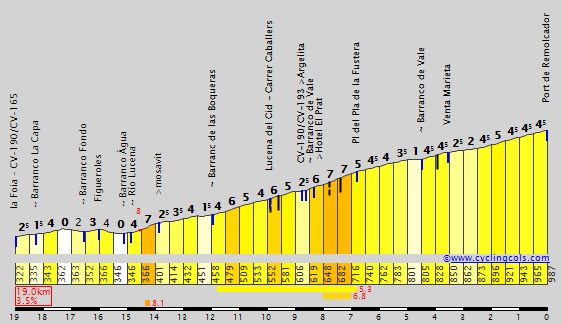

Puerto de Linares
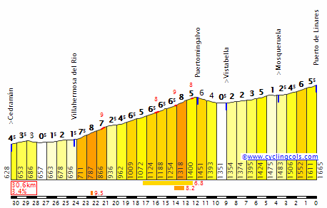

Estación de Esquí de Valdelinares
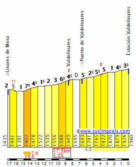

The next 60 km are fairly easy and get us to the base of Sierra de Javalambre. The final 24 km are entirely on sterrato (except for the last few hundred meters at the ski station) and include the climb of Puerto de Javalambre.


Puerto de Javalambre is 10,4 km long and has a average gradient of 6,5%. The climb goes up in three steps, interrupted by false flats. The first step is 2,4 km at 8,5%, the second 2,2 km at 8,2% and includes half a kilometer at 11%. The third step is 2,2 km at 8,5%. I'm pretty sure the race will explode on these demanding sterrato slopes.


We have now reached a high plateau, where we will stay for the rest of the stage. There are still 10 km to go, all on sterrato, on undulating terrain. The scenery is a completely barren landscape in the middle of nowhere.


The whole sterrato section is on Streetview, in case you can't see the imgur pictures. With 3 km to go we crack the 2.000 meter mark (just) on the highest point of the stage. The rest is downhill to the ski station of Javalambre. Here is a video of the descent, but only to the 1:16 mark, when they should have turned left to stay on our course.

There is plenty more sterrato in this area, by the way. One could build a true sterrato monster stage here, the only problem is that the ski station is the only possible location for a stage finish. Apart from that there are only tiny villages and wilderness.
(Fri) stage 18: Castellón de la Plana - Estación de Esquí de Javalambre, 188 km
We have reached the final weekend, time for a crucial mountain plus sterrato stage. The start is in Castellón de la Plana, a town of 170.000 people.
The first 100 km are inland and upwards, from sea level we are climbing to nearly 2.000 meters. After 60 km we enter Aragon, where we will stay for the rest of the stage.
Port del Remolcador
Puerto de Linares
Estación de Esquí de Valdelinares
The next 60 km are fairly easy and get us to the base of Sierra de Javalambre. The final 24 km are entirely on sterrato (except for the last few hundred meters at the ski station) and include the climb of Puerto de Javalambre.
Puerto de Javalambre is 10,4 km long and has a average gradient of 6,5%. The climb goes up in three steps, interrupted by false flats. The first step is 2,4 km at 8,5%, the second 2,2 km at 8,2% and includes half a kilometer at 11%. The third step is 2,2 km at 8,5%. I'm pretty sure the race will explode on these demanding sterrato slopes.
We have now reached a high plateau, where we will stay for the rest of the stage. There are still 10 km to go, all on sterrato, on undulating terrain. The scenery is a completely barren landscape in the middle of nowhere.
The whole sterrato section is on Streetview, in case you can't see the imgur pictures. With 3 km to go we crack the 2.000 meter mark (just) on the highest point of the stage. The rest is downhill to the ski station of Javalambre. Here is a video of the descent, but only to the 1:16 mark, when they should have turned left to stay on our course.
There is plenty more sterrato in this area, by the way. One could build a true sterrato monster stage here, the only problem is that the ski station is the only possible location for a stage finish. Apart from that there are only tiny villages and wilderness.
Re: Re:
The next flat stage is Stage 13.
Giro d'Italia
Stage 7: Frosinone -> Monte Terminillo (Plan de Valli)
225km
 Mountain stage


Yay, look at me being boring and choosing such a common climb for the first cat. 1 MTF... Thing is, I quite like the Terminillo as a climb, and given the length of this stage (225km) the riders will surely feel it in their legs. And this could have an effect on the remainder of the week, as the other two stages before the first rest day will also be focused on the GC and creating gaps.
Start is in Frosinone, where the riders ended the day before. Shortly after the start they face the cat. 2 Santopadre, which is 9.2km long at an average of 5.7%, so nothing too difficult. The middle section (about 160 km) is flat, passing through the Traguardo Volante in Avezzano and then the feed zone. There's a cat. 3 climb before the riders arrive in Rieti, for the second intermediate sprint, followed by another cat. 3. This leads onto the final climb, which, at 15.1km and 7.4%, is more than likely to create gaps. We saw Quintana secure his Tirreno-Adriatico win here a couple of weeks ago, and now it should be a GC battle again.
Tappa Valetti
This time, we're commemorating Giovanni Valetti, a two-time winner of the Giro d'Italia, in 1938 and 1939. Each time he did it, he won an individual time trial which started in Rieti and concluded on the Terminillo. He also finished in the top ten of the "Corsa Rosa" twice, in 1936 (5th) and 1937 (2nd). Those editions also replicated the Lazio Province MTT, but the first time it was Giuseppe Olmo who took the win, whilst Gino Bartali triumfed the year after. The climb then fell out of use, and didn't return to the Giro until 1987. Valetti, meanwhile, whose career ended in 1948 (although his last Giro was in 1940), a great climber, surely deserves a stage to himself, and why not make it the one where he took two victories on his journey to Italian glory?
Start: Frosinone, Via Marittima (km 0 is on the SP278, near Crescenzi)
Finish: Monte Terminillo (Pian de Valli), SS40bis
Intermediate sprints: Avezzano, Rieti
Feed zone: Cappelle
Climbs:
Santopadre (2nd Category, 692 m, 9.3 Km at 5.4%, Km 31.2)
Roccaranieri (3rd Category, 776 m, 5.6 Km at 6.3%, Km 171.9)
Cantalice (3rd Category, 679 m, 5.2 Km at 5.1%, Km 204.2)
Monte Terminillo (1st Category, 1675 m, 15.1 Km at 7.4%, finish)

Yes, oh boy, yes. I actually think I may have been too sadistic with the next stages.railxmig said:Your next post suggests a rather busy couple of days so i guess such a breakaway stage should be fine.
The next flat stage is Stage 13.
Thank you!Tonton said:I really like mikii's design so far
Giro d'Italia
Stage 7: Frosinone -> Monte Terminillo (Plan de Valli)
225km
Yay, look at me being boring and choosing such a common climb for the first cat. 1 MTF... Thing is, I quite like the Terminillo as a climb, and given the length of this stage (225km) the riders will surely feel it in their legs. And this could have an effect on the remainder of the week, as the other two stages before the first rest day will also be focused on the GC and creating gaps.
Start is in Frosinone, where the riders ended the day before. Shortly after the start they face the cat. 2 Santopadre, which is 9.2km long at an average of 5.7%, so nothing too difficult. The middle section (about 160 km) is flat, passing through the Traguardo Volante in Avezzano and then the feed zone. There's a cat. 3 climb before the riders arrive in Rieti, for the second intermediate sprint, followed by another cat. 3. This leads onto the final climb, which, at 15.1km and 7.4%, is more than likely to create gaps. We saw Quintana secure his Tirreno-Adriatico win here a couple of weeks ago, and now it should be a GC battle again.
Tappa Valetti
This time, we're commemorating Giovanni Valetti, a two-time winner of the Giro d'Italia, in 1938 and 1939. Each time he did it, he won an individual time trial which started in Rieti and concluded on the Terminillo. He also finished in the top ten of the "Corsa Rosa" twice, in 1936 (5th) and 1937 (2nd). Those editions also replicated the Lazio Province MTT, but the first time it was Giuseppe Olmo who took the win, whilst Gino Bartali triumfed the year after. The climb then fell out of use, and didn't return to the Giro until 1987. Valetti, meanwhile, whose career ended in 1948 (although his last Giro was in 1940), a great climber, surely deserves a stage to himself, and why not make it the one where he took two victories on his journey to Italian glory?
Start: Frosinone, Via Marittima (km 0 is on the SP278, near Crescenzi)
Finish: Monte Terminillo (Pian de Valli), SS40bis
Intermediate sprints: Avezzano, Rieti
Feed zone: Cappelle
Climbs:
Santopadre (2nd Category, 692 m, 9.3 Km at 5.4%, Km 31.2)
Roccaranieri (3rd Category, 776 m, 5.6 Km at 6.3%, Km 171.9)
Cantalice (3rd Category, 679 m, 5.2 Km at 5.1%, Km 204.2)
Monte Terminillo (1st Category, 1675 m, 15.1 Km at 7.4%, finish)
- Apr 15, 2016
- 4,247
- 680
- 17,680
@fauniera Very good stage. A harder version of Montalcino 2010 stage. Also when you finished the previous stage in Benicassim I thought you may do the San Rafael-Valdelinares-Villarroya-Tarascon-Valdelinares combo. Taarscon-Valdelinares final with many climbs before would be great as a weekend stage in a future race. Maybe Catalunya can use it in the future instead of La Molina.
Giro d'Italia
Stage 8: Rieti -> Porto Sant'Elpidio
227km
Medium-mountain stage


Oh, geez, this will be a day of pain, suffering and breaking legs. The profile itself is up and down all day and although the highest category we'll see today is cat. 3, some of the walls and slopes will definitely hurt. And given that there's 12 climbs on the menu, this really is reminiscent of a Flèche Wallonne or Liège-Bastogne-Liège. Oh, and by the way, it's the longest stage of this Giro, at 227km (two 220+km stages in a row... mmmmm )
We leave from Rieti, at the foot of Terminillo, where the previous stage finished. From km 0, it's a furious ride through Lazio and from the entry into Marche, it gets tricky. After the intermediate sprints in Acquasanta Terme and Ascoli Piceno is when the climbing starts. Some of the ascents are at about 5%, but some come close to averaging 8%. None of the climbs are particularly long, though, with the longest being Monterubbiano, at 4.5km.
There are two climbs that I would like to draw attention to, though, and those are the final two. First is Montegranato Nord (there are two climbs to Montegranato, one from the south and one from the north, and the KOM sprints are in different places. I'm talking about the second ascent). It's only 1.1km long but averages a painful 14.0%, with sections near 20%. Also it's fairly consistent, so we don't go below 10% at all. I mean, even the streetview of it is difficult to watch.

btw, that shows the climb from the reverse
The second is the final ascent, Sant'Elpidio a Mare. We've seen it in Tirreno-Adriatico, where it was known to cause difficulty, especially in 2013, when it was climbed in pouring rain. The victor was Peter Sagan. At 2.0km and 8.2%, it will be the finishing touch to a brutal day.

The line is in Porto Sant'Elpidio, again, a town known from the Race of two Seans,
Speaking of which....
Tappa Tirreno-Adriatico
RCS Sport likes to commemorate its other races, and I'm doing so by visiting regions utilised by the spring race. This year's edition was the 52nd ever race. It was made in 1966 by a Lazio-based club to contrast the other climbers' races, held primarily in the North. Named the Three Days of the South, the start of the first stage was in Rome and, two days later, the finish was in Pescara. Dino Zandegù was the victor. The race is named after the fact that it links the Tyrrhenian and Adriatic seas. Currently, it starts in Lido di Camaiore and ends with an ITT in San Benedetto del Tronto. Porto Sant'Elpidio, along with the area seen in this stage is visited year-on-year (most recently with a hilly stage ending in Fermo, claimed by Sagan) in the concluding section of the race.
Start: Rieti, Via Battistini (km 0 is on the SS29 in Vignaletto)
Finish: Porto Sant'Elpidio, Via Trieste
Intermediate sprints: Acquasanta Terme, Ascoli Piceno
Feed zone: Castagneti
Climbs:
Morro Reatino (3rd Category, 762 m, 7.0 Km at 5.4%, Km 7.0)
Fuscello (3rd Category, 1101 m, 8.1 Km at 4.3%, Km 20.1)
Maltignano (4th Category, 292 m, 3.5 Km at 6.2%, Km 122.8)
Offida (4th Category, 317 m, 1.8 Km at 5.9%, Km 144.7)
Trivio (4th Category, 287 m, 2.3 Km at 7.3%, Km 152.4)
Biondi (4th Category, 245 m, 2.7 Km at 5.9%, Km 163.4)
Monterubbiano (3rd Category, 360 m, 4.5 Km at 5.8%, Km 170.8)
Fermo (4th Category, 201 m, 3.0 Km at 5.5%, Km 181.1)
Monte Urbano (4th Category, 203 m, 2.3 Km at 6.2%, Km 190.8)
Montegranato (sud) (4th Category, 179 m, 2.4 Km at 5.5%, Km 198.2)
Montegranato (nord) (3rd Category, 224 m, 1.1 Km at 14.0%, Km 209.1)
Sant'Elpidio a Mare (3rd Category, 233 m, 2.0 Km at 8.2%, Km 216.2).
Stage 8: Rieti -> Porto Sant'Elpidio
227km
Oh, geez, this will be a day of pain, suffering and breaking legs. The profile itself is up and down all day and although the highest category we'll see today is cat. 3, some of the walls and slopes will definitely hurt. And given that there's 12 climbs on the menu, this really is reminiscent of a Flèche Wallonne or Liège-Bastogne-Liège. Oh, and by the way, it's the longest stage of this Giro, at 227km (two 220+km stages in a row... mmmmm
)We leave from Rieti, at the foot of Terminillo, where the previous stage finished. From km 0, it's a furious ride through Lazio and from the entry into Marche, it gets tricky. After the intermediate sprints in Acquasanta Terme and Ascoli Piceno is when the climbing starts. Some of the ascents are at about 5%, but some come close to averaging 8%. None of the climbs are particularly long, though, with the longest being Monterubbiano, at 4.5km.
There are two climbs that I would like to draw attention to, though, and those are the final two. First is Montegranato Nord (there are two climbs to Montegranato, one from the south and one from the north, and the KOM sprints are in different places. I'm talking about the second ascent). It's only 1.1km long but averages a painful 14.0%, with sections near 20%. Also it's fairly consistent, so we don't go below 10% at all. I mean, even the streetview of it is difficult to watch.
btw, that shows the climb from the reverse
The second is the final ascent, Sant'Elpidio a Mare. We've seen it in Tirreno-Adriatico, where it was known to cause difficulty, especially in 2013, when it was climbed in pouring rain. The victor was Peter Sagan. At 2.0km and 8.2%, it will be the finishing touch to a brutal day.
The line is in Porto Sant'Elpidio, again, a town known from the Race of two Seans,
Speaking of which....
Tappa Tirreno-Adriatico
RCS Sport likes to commemorate its other races, and I'm doing so by visiting regions utilised by the spring race. This year's edition was the 52nd ever race. It was made in 1966 by a Lazio-based club to contrast the other climbers' races, held primarily in the North. Named the Three Days of the South, the start of the first stage was in Rome and, two days later, the finish was in Pescara. Dino Zandegù was the victor. The race is named after the fact that it links the Tyrrhenian and Adriatic seas. Currently, it starts in Lido di Camaiore and ends with an ITT in San Benedetto del Tronto. Porto Sant'Elpidio, along with the area seen in this stage is visited year-on-year (most recently with a hilly stage ending in Fermo, claimed by Sagan) in the concluding section of the race.
Start: Rieti, Via Battistini (km 0 is on the SS29 in Vignaletto)
Finish: Porto Sant'Elpidio, Via Trieste
Intermediate sprints: Acquasanta Terme, Ascoli Piceno
Feed zone: Castagneti
Climbs:
Morro Reatino (3rd Category, 762 m, 7.0 Km at 5.4%, Km 7.0)
Fuscello (3rd Category, 1101 m, 8.1 Km at 4.3%, Km 20.1)
Maltignano (4th Category, 292 m, 3.5 Km at 6.2%, Km 122.8)
Offida (4th Category, 317 m, 1.8 Km at 5.9%, Km 144.7)
Trivio (4th Category, 287 m, 2.3 Km at 7.3%, Km 152.4)
Biondi (4th Category, 245 m, 2.7 Km at 5.9%, Km 163.4)
Monterubbiano (3rd Category, 360 m, 4.5 Km at 5.8%, Km 170.8)
Fermo (4th Category, 201 m, 3.0 Km at 5.5%, Km 181.1)
Monte Urbano (4th Category, 203 m, 2.3 Km at 6.2%, Km 190.8)
Montegranato (sud) (4th Category, 179 m, 2.4 Km at 5.5%, Km 198.2)
Montegranato (nord) (3rd Category, 224 m, 1.1 Km at 14.0%, Km 209.1)
Sant'Elpidio a Mare (3rd Category, 233 m, 2.0 Km at 8.2%, Km 216.2).
- Feb 20, 2010
- 33,227
- 15,741
- 28,180
Of course in a real Giro, they'd only categorise two or three of those, and probably not the hardest ones either 0_O
TRENDING THREADS
-
 Paris-Roubaix 2026, one day monument, April 12
- Started by Lequack
- Replies: 2K
-
 Itzulia Basque Country 2026, April 6-11
- Started by Dazed and Confused
- Replies: 2K
-
 Ronde van Vlaanderen 2026, monument, April 5 (men's)
- Started by Krzysztof_O
- Replies: 1K
-

-
 Teams & Riders The Remco Evenepoel is the next Eddy Merckx thread
- Started by DNP-Old
- Replies: 39K
-
 Teams & Riders Tadej Pogačar discussion thread
- Started by Lequack
- Replies: 43K
-
De Brabantse Pijl 2026, April 17
- Started by Dazed and Confused
- Replies: 160


Cyclingnews is part of Future plc, an international media group and leading digital publisher. Visit our corporate site.
© Future Publishing Limited Quay House, The Ambury, Bath BA1 1UA. All rights reserved. England and Wales company registration number 2008885.