• The Cycling News forum is looking to add some volunteer moderators with Red Rick's recent retirement. If you're interested in helping keep our discussions on track, send a direct message to @SHaines here on the forum, or use the Contact Us form to message the Community Team.

    In the meanwhile, please use the Report option if you see a post that doesn't fit within the forum rules.

    Thanks!

Race Design Thread

Page 255 - Get up to date with the latest news, scores & standings from the Cycling News Community.
Re: Re:

Giro d'Italia
Stage 21: Monza -> Milano
102km
22px-Plainstage.svg.png
Flat stage
1upa6iY.png

S7fi0sK.png


The final stage is the parade in Milan. A final opportunity for the remaining sprinters, and a nice and peaceful day for the GC contenders.

The start is Monza, on the Autodromo Nazionale, which the riders will lap before setting off on the journey towards Milan. They pass the feedzone prior to entering the final circuit, which will be completed six times. On the second and fifth passage of the finish line will be the final intermediate sprints of this "Corsa Rosa".
5PS9lbY.png


Afterwards, all that remains is the traditional prize-giving ceremony.

Start: Monza, Rettifilio Tribune (km 0 is at the second Curva Lesmo)
Finish: Milano, Corso Sempione
Intermediate sprints: Milano, Milano
Feed zone: Lorenteggio

FINAL SUMMARY COMING SHORTLY
 
Giro d'Italia - final summary
aKtRHp5.png


1: Lecce -> Lecce 9.7km
20px-Time_Trial.svg.png
Individual time trial **
2: Lecce -> Nardo (Ring)198km
22px-Plainstage.svg.png
Flat stage *
3: Brindisi -> Mottola 166km
22px-Hillystage.svg.png
Hilly stage ***
4: Massafra -> Monte Sirino 182km
22px-Mediummountainstage.svg.png
Medium-mountain stage ****
5: Brienza -> Benevento 217km
22px-Mediummountainstage.svg.png
Medium-mountain stage ***
6: Benevento -> Frosinone 174km
22px-Plainstage.svg.png
Flat stage *
7: Frosinone -> Monte Terminillo (Plan de Valli) 225km
22px-Mountainstage.svg.png
Mountain stage ****
8: Rieti -> Porto Sant'Elpidio 227km
22px-Mediummountainstage.svg.png
Medium-mountain stage ****
9: Porto Sant'Elpidio -> San Giacomo 122km
22px-Mountainstage.svg.png
Mountain stage ****

- rest day -

10: Perugia -> Siena 182km
22px-Hillystage.svg.png
Hilly stage ***
11: San Gimignano -> Abetone 204km
22px-Mountainstage.svg.png
Mountain stage ****
12: Maranello -> Modena 46.6km
20px-Time_Trial.svg.png
Individual time trial ****
13: Modena -> Schio 194km
22px-Plainstage.svg.png
Flat stage *
14: Asiago -> Selva di Val Gardena 219km
22px-Mountainstage.svg.png
Mountain stage *****
15: Selva di Val Gardena -> Tre Cime di Lavaredo 108km
22px-Mountainstage.svg.png
Mountain stage *****

- rest day -

16: Costiglione d'Asti -> Canelli 45.7km
20px-Time_Trial.svg.png
Individual time trial ***
17: Acqui Terme -> Gallarate 146km
22px-Plainstage.svg.png
Flat stage *
18: Varese -> Pescegallo 213km
22px-Mountainstage.svg.png
Mountain stage *****
19: Morbegno -> Bergamo 163km
22px-Hillystage.svg.png
Hilly stage ***
20: Bergamo -> Aprica 200km
22px-Mountainstage.svg.png
Mountain stage *****
21: Monza -> Milano 102km
22px-Plainstage.svg.png
Flat stage

KOM Sprints: 76
Cima Coppi: Tre Cime di Lavaredo, 2320m (15)
1st category: 11
Monte Terminillo (7), San Giacomo (9), Passo di Pradaccio (11), Passo Duran, Passo Fedaia (14), Passo Giau (15), Valcava, Passo San Marco, Pescegallo (18), Passo del Mortirolo, Monte Padrio (20).
2nd category: 15
Tempa Rossa, Monte Sirino (4), Valico della Carbonara, Monte Terminio (5), Santopadre (7), Montemoro, Monsampietro (9), Passo del Vestito, Abetone (11), Forcella Staulanza, Passo Sella (14), Passo Valparola, Passo Tre Croci (15), Passo della Presolana, Passo del Vivione (20).
3rd category: 29
Mottola (3), Armento, Moliterno (4), Caggiano, Scorza, Montefredane, Colle di Campore (5), Roccaranieri, Cantalice (7), Morro Reatino, Fuscello, Monterubbiano, Montegranato (nord), Sant'Elpidio a Mare (8), Caselunghe, Monte San Martino, Scentella, Cimagallo (9), Bagnaia a Grotti Alto (10), Passo Gardena (15), Cassinasco, Pian Canelli (16), Berbenno, Forcella di Bura (18), Villa Vergagno, Monte Marenzo, Gronfaleggio, Colle dei Roccoli (19), Passo dell'Aprica (20).
4th category: 20
Schillanti (2), Comune di Martina Franca, San Simone, Palagianello (3), Montecorvino Rovella, Sorbo Serpico (4), Maltignano, Offida, Trivio, Biondi, Fermo, Monte Urbano, Montegranato (sud) (8), Casanova, Siena (10), Colle Santa Lucia (14), San Marzano Oliveto (16), Valmadonna (17), Olda (18), Bergamo Alta (19).

TOTAL LENGTH: 3344km
Average stage length: 159.2km

Flat stages: 5
Hilly stages: 3
Medium-mountain stages: 3
Mountain stages: 7
Individual time trial stages: 3
Team time trial stages: 0

Total individual time trialing: 102kms
Total team time trialing: 0kms

MTFs: 6
Monte Sirino (4, cat. 2), Monte Terminillo (7, cat. 1), San Giacomo (9, cat. 1), Abetone (11, cat. 2), Tre Cime di Lavaredo (15, Cima Coppi), Pescegallo (18, cat. 1)
HTFs: 1
Mottola (3, cat. 3)

Thank you very much for following, I hope you enjoyed my Giro :D :D
 
I've been thinking of doing this for a while and may as well start with it.

This is not really a post for the idea of a race in and of itself, but more a discussion of investigating the possibilities, along the lines of posts we've had discussing existing GT routes and their alternatives, or along the lines of the occasional Paradores series at plataformarecorridosciclistas, where the route design options yielded by various Paradores are discussed with each post focusing on a different location. So I've thought of doing the same, tying together things I have done as parts of individual routes but with a more cohesive narrative and also where the options are myriad.

The sport of cycling owes a lot to skiing, as while many of the great passes that make up the paths through the mountains that lend cycling many of its myths and legends were cut long ago, the development of the skiing industry has served as a massive boon for the sport in terms of producing finishing locations high in the mountains, creating iconic summits like Alpe d'Huez and Sestrières along with many renowned moments, like Roche emerging from the fog at La Plagne, Ullrich grinding everyone into dust to Arcalis, Fuente's legendary Formigal raid or Pantani's arrival at Les-Deux-Alpes. Cities and regions that thrive through the winter on their skiing industries use this to pay for the arrival of major races, giving us great design options for stages finishing in towns like Aosta, Cortina d'Ampezzo, Sion, Albertville, Bourg-Saint-Maurice and so on, while places from which a number of resort routes emanate, such as Andermatt, Andorra-la-Vella or Les-Trois-Vallées, offer variety even while the same stage hosts are paying up. Ski resorts are a part of life in cycling, and not just in the biggest races - the Kitzbüheler Horn of course features annually in the Österreichrundfahrt, while the Beaver Creek resort hosted the USAPCC.

mountainviewtreefrontbvc3287jack%20affleck.ashx


One of the benefits of Alpine skiing to this end, of course, has been that the need for a number of runs with significant altitude change and the amenities to deal with numbers of tourists, competitors and their requirements means that you'd often have sufficient space and facilities to host the race, opening up choices for mountaintop finishes, that easiest of ways to push for selectivity in courses. However, Alpine is of course not the only type of skiing, although obviously popularity in different locations is a large part of why Nordic and Alpine skiing have their relevant names.

One of the important things about Nordic skiing from a cycling point of view, however, is that it doesn't have the same requirement for large altitude gain or loss, and therefore the sites on which Nordic resorts and centres are built show much more variety in terms of accessibility and the roads by which you get by them, which can create a lot of opportunity for the budding traceur. Obviously, as you're well aware, I am a huge fan of Nordic sports, and as a result many a cross-country or biathlon venue has crept into my race designs over the years. In fact, although the sport of cycling is much more indelibly linked in terms of amenities, locales and so on with Alpine skiing, from a sporting perspective there's clearly much more crossover in terms of fans with the Nordic sports, as the difference in the relative popularity of the threads in the General forum dedicated to Nordic and to Alpine skiing demonstrates (although the Nordic disciplines does include four different sports, not that ski jumping or Nordic Combined have contributed that many of the posts).

Nordic locations may be the ski centres par excellence in emerging cycling markets like Scandinavia (I used many in my Tour of Norway of course), but because of the popularity of skiing throughout Europe and the more reliable snow at altitude, there are a range of Nordic venues of some repute dotted all over mainland Europe in both major and minor mountain ranges. While I have focused on those that are capable of hosting international calibre competition, these are by no means the only ones. And there is some history of using these in major races, especially in recent years. The most famous of these, undoubtedly, is the Plateau de Beille. With its flat and rolling terrain atop a mighty, brutal Pyrenean ascent, its conversion into a Nordic paradise made its access road, er, accessible for cycling. It was introduced to the Route du Sud in 1995, and its success led to the Tour arriving in 1998. In winter, however, it is the best-known XC and biathlon centre in the Pyrenees, with its most famous alumna being Vancouver Olympic medalist Marie-Laure Brunet, a slow skier but with a sure shot whose career after that breakthrough was blighted by health problems and halted at the age of just 25 after a scary blackout and collapse in the relay at Sochi.

beille-1-52711724be2ac.jpg


Other Nordic skiing locations in the Pyrenees have emerged in cycling recently too; in 2008 the Vuelta had its first finish at Naturlandia La Rabassa, the only Andorran resort dedicated to XC - unfortunately terrible weather meant little available footage. And in 2016 the Route du Sud unveiled a new mountaintop finish at the Station de Ski Couraduque, which saw Marc Soler's first pro win. None of these are, however, international-level venues, as the appeal of Nordic skiing is comparatively limited in the Pyrenees compared to the Alps where you have the borders with Germany and its love of biathlon, and the glut of cross-country venues along various valleys in Italy with major ski touring and marathon races like the Marcialonga. In the Alps you have a lot of locations which are known from bike racing, from valley towns like Davos (a hub in recent Tours de Suisse), to towns on sizable plateaus such as Asiago (which will host a key stage in the 2017 Giro). A famous location is Zoldo Alto, which hosted an incredible stage in the 2005 Giro where Paolo Savoldelli won the time that won him the race, thanks to his almighty descending skills. The spot where they finished, Palafavera, has since become an up-and-coming biathlon venue, while ten years earlier the 1995 Giro stage to Lenzerheide passed through an extant XC landscape that has now become a world-renowned venue. The most famous such location, of course, is Le-Grand-Bornand, which is something entirely unique in the world of biathlon - a permanent temporary venue, patterned after places like cycling's Krylatskoye Ring and motor racing's Marina Bay Street Circuit - the shooting range and part of the ski trails are permanent, however the actual stadium section is temporary, with parts of the trails going into the village itself, and the start-finish line being over an actual road - the same road, in fact, used as the finish when the Tour de France has finished in LGB, albeit facing the opposite direction.

slide-illustration-stade.jpg


An international-level Nordic venue will need to host a good 200 athletes and their support staff, technical team, and be able to transport those in and out, with adequate parking for fans, staff and competitors alike; in short, everything you need to host a top level bike race, so utilizing these for cycling should not present a problem. In many cases, the stadium sections of the venues can be pressed into action as makeshift areas for the race caravan to make their beds.

The types of finishes available at Nordic venues can vary wildly, because the necessity of large and severe mountain slopes is removed and in fact much of the time all you need is access to some skis and you can head on your way. Nordic venues at the top of a major climb that is not available for use at a pass are rare - although in addition to the Plateau de Beille, Val Martello does have an international biathlon stadium at 1600m. Stadia atop smaller climbs, or partway up larger climbs (as a mid-station for neighbouring Alpine resorts occasionally) offering more variety of route are much more common, which makes them potentially attractive to traceurs for their versatility. And in non-traditional cycling countries, they can often create ways to break things up, especially where tarmacked ski runs are the order of the day due to hosting rollerski events, as short and sharp digs repeating, in the same manner as the 1980 Summer Olympics course, create myriad possibilities to create something decisive and make racing harder to control.

I did think about starting this in the Unknown MTFs thread, because the first venue I wanted to deal with has a mountaintop finish, but then several locations wouldn't be MTFs of the traditional description and others wouldn't be MTFs at all, and so really, the posts belong in here.
 
I was surprised by the disparity and I do enjoy some Alpine skiing, but I'm firmly in the Nordic camp.

Nordic Series 1: Plateau des Confins (La Clusaz)

As mentioned above, the skiing town of Le Grand-Bornand has become a known stop-off for the Tour, and currently plays host to the French round of the Biathlon World Cup (after being introduced in the IBU Cup in 2011-12, it was introduced to the World Cup in 2012 but relocated to Hochfilzen due to lack of snow, before getting up and running for real in December 2013 (here's the first race of that meet, the women's relay) and now being brought back for 2017-18. The Tour has been here four times for stage finishes, utilizing two different approaches. The first, introduced in 2004 and repeated in 2013, was to arrive off of the descent from the Col de la Croix-Fry. Those two times came after identical stages from Bourg d'Oisans, over Glandon, Madeleine, Tamié, l'Épine and Croix-Fry.

Tour_2013_stage_19_Bourg_DOisans-Le_Grand_Bornand.jpg


The other two times, 2007 and 2009, the riders came over the Col de la Colombière from its tougher side, from Cluses. In 2007's early mountain stage this cat.1 climb was the only significant obstacle of the day, however in 2009 ASO unearthed the attached Col du Romme, giving us a great one-two punch to finish the stage and providing us with the only defensible thing about the 2009 Tour at all, stage 17 from Bourg-Saint-Maurice to Le Grand-Bornand.

09_profil_etape17.gif


This was one of the finest pieces of stage design Christian Prudhomme ever greenlit, and gave us a lot of entertainment, from Thor Hushovd's solo mountain breakaway to secure the maillot vert, to hostilities being initiated at the very base of Romme by Sastre in a final, last-ditch attempt to salvage some dignity from his tour defence even though he knew he didn't have the legs, to the controversy when Contador abandoned Klöden and the Schlecks worked with him to the end with Fränk being gifted the stage. Watch the only good thing about the 2009 Tour here.

The town has also hosted the Tour de l'Avenir, such as in this stage from 2012, descending the normally-climbed side of Croix-Fry and climbing into the resort via the gradual, low-gradient rumble of the Côte de Saint-Jean-de-Sixt.

However, this post isn't about Le Grand-Bornand, the biathlon venue, but actually about the nearby venue that hosts the FIS Cross-Country World Cup in the neighbouring resort of La Clusaz - the Espace Nordique des Confins.

espace-nordique-des-confins_4f0700fb77133.jpg


You can see above the network of trails and the buildings through which riders would have to ride to get to the very summit here, but also from this aerial view some car parking opportunities that enables plenty of the race caravan and accompanying flotsam and jetsam to set up shop, and get on with the business of race hosting. Especially as it's only a short ride down to La Clusaz and Le Grand-Bornand, so transfers can be minimal, and where necessary extraneous stuff can be kept down there. There's room for a diversion of the team cars etc., and the VIP tents, spectator stuff and all of that assorted side business can be set up in the nordic stadium itself. Although that shouldn't be necessary - if you look at the video from the XC World Cup this season you can see before the race begins just how much room there is, as a lack of natural snow means you can see the area looking a bit more like it would in summer. And a little way after the summit there's an additional area for parking too.

74-la-clusaz-confins001.jpg


And of course, the stadium comes at the end of a climb, but not a very difficult one, which incentivises earlier moves and allows for quite a range of outcomes. Here's the profile:

Confins.gif


That profile is all the way from Thônes so includes a fair amount of false flat first. The road from Le Grand-Bornand joins the climb at Saint-Jean-de-Sixt, so giving us a final climb of around 9km @ 5,5%; if we come via Croix-Fry or Aravis, however, we don't join the climb until La Clusaz itself, yielding 6km @ 6,7% or even, if we don't go via the village itself and stick to the major road slightly above, 5km @ 6,8%. The only really tough spot, and thus the only place on the climb itself automatically signposted to produce a decisive attack, is the kilometre averaging 10,4% into Le Crêt Baffaz with 3km remaining.

For the most part in my routes I have operated with the opinion that the Col du Plan-Bois is passable; certainly I think it's definitely usable in the smaller races in the area like the Tour des Pays de Savoie, the Tour de l'Avenir and the Dauphiné, but if ASO are worried about the descent being dangerous (it's certainly not more dangerous than some they've used in the past, such as Pramartino, but I also remember the fuss about the Pramartino descent in 2011 even though the Giro péloton had safely negotiated it with no such fuss in 2009) then this climb can be bypassed and l'Épine can be linked directly to Croix-Fry as per the 2004 and 2013 Tour stages.

Stage proposal #1: St Jean de Maurienne - Plateau des Confins, 160km

xgd5oy.png


Of course, this is not dissimilar from the Bourg d'Oisans - Le Grand-Bornand stages of Tour history, although I've elected to use ASO's recent discovery of the Col de Chaussy to give us a less well-trodden introduction to the stage, as well as putting quite significant KOM points early in the stage to encourage some really aggressive fighting to be in the breakaway and also the complete cold-open straight to a severe climb, backed into one of the Alps' true monsters in the southwest face of the Col de la Madeleine, will mean that there's no chance for riders to ride their legs into the stage before they have to really put them to the test. There's then a nice flat section through the middle to allow the break to consolidate and to put the intermediate sprint in (I anticipate that maillot vert contenders may have some trouble making this one, but the descent of Madeleine is long and tricky enough that if Sagan is on his form from when he won the Tour de Suisse stage over Großer Scheidegg and goes all out on the descent, maybe he'll get there, I don't know) where those stages included Tamié, before taking the Col de l'Épine into a tough double-header over Plan-Bois - shortish but very steep; 600m longer and a full % steeper than Planche des Belles Filles, essentially nestling into the same kind of territory as Urkiola and Peña Cabarga, although slightly longer than either - before a tight descent at a fairly consistent 8% and then, after a 500m ramp at 11%, the last 8km of Croix-Fry.

PlanBoisW.gif
CroixFryW.gif


Plan-Bois crests only 25km from the finish in this brutal finale, so its steepness should hopefully get rid of most helpers, and the technical nature of the descent should hopefully make it hard to get back on before Croix-Fry, which itself crests just 12km from the line, with then the final 6km climb up to the ski station at Les Confins to finish. This triple-header finish could create some really monstrous racing given the direction of the stage could make this potentially the final mountain stage of a race, coming off the back of a Maurienne Valley stage with potential MTFs at places like La Toussuire (though the stage would have to be more like stage 16 in 2006 where Landis collapsed, given recent stages in 2012 and 2014 have been from the opposite direction, so my Confins stage would be retracing our steps), Valloire/Galibier (like the 2013 Giro stage over Mont-Cenis), or Valmeinier (as in the 2016 Tour de l'Avenir stage).

Stage proposal #2: Saint-Jean-de-Maurienne - Plateau des Confins, 156km

23r61iv.png


Same start and finish towns, but what we have here is a high-mountain stage of potentially dangerous proportions, yet without super-climbs, so we have a potential diesel climber's nightmare, continually turning on and off the engine over cat.2 climbs of varying kinds. The Côte de Bonvillard is a little-heralded climb not seen since 1982, but is a potential banana skin. The issue with this stage as compared to the previous one is that the obstacles don't come immediately so the riders have the chance to ease into the day's obstacles, however we do have the benefit of no real respite section once the climbs have begun, as the longest bit of plateau riding after they start Bonvillard is around 10km in length around the town of Ugine, and with the intermediate sprint taking place in this break (it's also much more likely to see potential green jersey candidates - especially if the likes of Matthews and Coquard want to duel for it - making this part of the race hard than in the previous proposition) it may not be as easy as some of the contenders may hope. I've also included Tamié, which was excluded from the first stage (although if ASO don't like the look of Plan-Bois, it can be plugged in to beef up the middle of the stage as there would then be less chance of Croix-Fry being selective otherwise).

Stage proposal #3: Bessans-Haute Maurienne - Plateau des Confins, 160km

1r4yo6.png


Here we have a stage which links La Clusaz with the town that used to host the French biathlon World Cup round before the country came off the menu until recent years when Martin Fourcade's domination and the popular Marie Dorin-Habert have brought the sport back to the public eye in the French Alps. I may do more detail on Bessans later, so I won't bother you with it now.

The run-in on this stage is much easier than the previous ones, without the pummelling one-two punch so close to the finish, but this does mean the riders will need to make more of the earlier obstacles. Starting at the upper end of the Maurienne gives us the opportunity to use July's propensity for better weather and use the Col de l'Iseran, the highest paved pass in Europe, right from the word go, which will be no fun as coming straight off a cold open into such a high altitude HC climb could well have an effect, although the descent into Bourg-Saint-Maurice is in fairness pretty interminable. This then enables us to head through the first part of that 2009 stage to LGB, over some serious climbs. First up is the Cormet de Roseland, on the border between cat.1 and HC, and then following ASO's recent discovery of it, I've included Mont Bisanne rather than its close neighbour the Col des Saisies, although the latter could also be used if desired; going via Mont Bisanne in the northward direction does mean that you have to produce a double-summit as you then go through Les Saisies on the way back to the Flumet road. Here, Mont Bisanne crests 42km from the line, and is the toughest climb of the day so offers an opportunity for a long-distance raid given there's only two cat.2 climbs remaining. The climb has seldom been used in a position to be decisive though it has played key roles in the race before, not least in 2006 as part of that Floyd Landis stage. With the main difficulty being only around 7km @ 7% it won't destroy people unless there's a lot of lone foraging done by domestiques dropping on Mont Bisanne; but cresting 13km out and with a fairly easy descent into La Clusaz before the final climb it could mean it's a very select group fighting on that final ascent so any gaps made on that 1km @ 10,4% section to Les Confins could create bigger gaps than you might otherwise expect.

Stage proposal #4: Morillon - Plateau des Confins, 133km

34dqzaf.png


If you don't approach La Clusaz from the south, there's still options, it just means the final climb is a bit longer, utilizing a bit more false flat before it begins. Given the trend in modern cycling and ASO's current propensity for it, here is a short, but action-packed killer mountain stage compressing six serious climbs into a little over 130km covering a pretty small geographic area. This would link perfectly as the follow-up stage to an MTF at the as yet unused by the pros Plateau des Saix - 10km at 9%, a proper HC climb that ought to open up gaps of its own volition, and with a short mountain stage following to prevent riders being too timid, it could be great. In smaller races, the Plateau des Glières and Plateau de Solaison have both also hosted mountaintop finishes, while there's also the less steep but much longer Col de la Pierre Carrèe, with its 4km descent into Flaine. There's another MTF in the region that is an option, but I'll get to that another time.

Again, like with my first proposal, this stage comes haring out of the blocks with a brutal ascent, to test the warm-up speeds of the riders, since the Col de Joux-Plane is very unforgiving, as we know. If ASO think 133km is too long, they can always head directly from Morzine to the Col de l'Encrenaz, however I vastly prefer the route via the Col de Joux-Verte, a little way below the well-known summit finish at Avoriaz, as this backs up the difficult climbing and ensures little respite for the riders - there's pretty much no flat whatsoever in this stage. Joux-Verte has only been used as a pass once in the Tour, in 1981, when Robert Alban won the stage from a long-distance run, underpinning his GC podium and scoring his biggest career triumph, but its ability to be backed onto Joux-Plane means it's sadly underutilised given that that is the only time we've seen the double header in a decisive position. After this it's back to Cluses over the Col de l'Encrenaz and a long descent broken up by the Côte du Chatillon, which sometimes is categorized but not normally from the north. After that, we have the double whammy of Romme and Colombière, known from the 2009 Tour, and sadly (and surprisingly) not reused at all since.

RommeN.gif
ColombiereN.gif

(last 7,5km of Colombière only)

This puts the finish of Romme with 34km remaining and Colombière with 22, but again if ASO think the stage is too long we can repeat the finish from 2009 in Le Grand-Bornand, however I have appended the 9km @ 5,5% of this side of the climb to the Espace Nordique des Confins; as the stage is so short I don't think there is as likely to be the issue of people waiting for the final climb, and so the MTF shouldn't detract from racing elsewhere, much like Andalo 2016, Alpe d'Huez 2011 and so on.

Stage proposal #5: Thônon-les-Bains - Plateau des Confins, 153km

2vcamg4.png


The last proposal is also quite a short stage, linking together both of the sets of lead-in climbs with a stage beginning at the shores of Lac Léman. In terms of connectivity with other stages, this would be harder to set as a follow-up to another major mountain stage unless coming from Switzerland and backing up a stage in the Valais or re-entering France via the Pas de Morgins. As a result it may be better suited to a Dauphiné than Le Tour, but it's pretty all-action for its short duration again. We do climb the Col du Ranfolly, the easier side of Joux-Plane from Morzine, so it would be possible to add the other side of Joux-Verte to toughen up the stage, but I thought with 5 cat.1 climbs - albeit not too many of the long and grinding variety and more of the medium-length-but-steep kind - and the cat.2 finish, that wouldn't be necessary. After all, there's four cat.1 climbs and a cat.2 crammed into the final 80km, with the intermediate sprint coming in Le Grand-Bornand on the descent from the Colombière, only this time we do the full descent into Thônes (thus doing the reverse of the final climb from the Avenir stage mentioned above), so that between the summit of Colombière 57km from the line and the start of Plan-Bois with 31km remaining, apart from the brief uphill dig into Saint-Jean-de-Sixt, there's literally only 3km from Thônes to Les Clefs that are flat. From that point on, it's as per propositions #s 1 and 2, with Plan-Bois 25km from the line, Croix-Fry 12km out, and then the final 6km climbing up to the Nordic ski station. This stage also would be the one that would still hold together best if Plan-Bois was deemed impassable by ASO - the conventional climb to Croix-Fry as used in the 2004 and 2013 Tours begins in Thônes, so would come right off the back of the descent of the Romme-Colombière double-punch, and we could just add Joux-Verte earlier as an additional challenge to tighten up the first half of the stage.

19556432.jpg


As you can see, the location for the stadium here gives myriad possibilities to link to different climbs - I didn't even include the Plateau des Glières as I wasn't sure ASO would be happy descending the steeper side of it, which is narrow and not in great condition, although it could perhaps be climbed, then descending the side they used as an MTF in the Tour de l'Avenir a couple of years ago - however this would require a stage that rather loops around itself, maybe La Clusaz - La Clusaz over Glières, Fleuries, Ramaz, Romme and Colombière before the summit finish. But there's so many options here, it's really a shame La Clusaz doesn't get in on the Tour de France bandwagon.
 
Nordic Series 2: Les Plans d'Hotonnes

For many years the preserve of forlorn wishes of traceurs and the Tour de l'Ain only, the Jura massif is coming into vogue in ASO's races following their discovery in 2012 of the Tour de l'Ain's signature climb (which they've since lost the use of seemingly), the Col du Grand-Colombier. Initially used in Wiggins' triumphal year, the climb was misused some way out in a stage that would actually have been pretty well-designed if it wasn't leading into one of the only real multi-mountain odysseys of the race, discouraging anybody from taking risks. The climb has also been a mountaintop finish when used in smaller races, while last year part of the climb was climbed, then the other part was climbed later in a relatively nicely put together stage won from the break by Jarlinson Pantano. In 2017 some of the other beasts of the Jura get welcomed to the race, so ASO are discovering the potential that this region has, closely linked to the Alps and so perfect for a stage moving out of that range and towards Paris as the race heads for a climax.

And this would therefore be a good time to capitalize for the international XC and biathlon stadium at Les Plans d'Hotonnes, on the Plateau de Retord. A former host of the IBU Cup, the Jura has long been the cradle of much of the French Nordic passion, and this particular venue has given the country two of its best loved biathlon women, two-time Individual World Champion and Olympic relay champion turned coach Corinne Niogret and 2004-5 overall World Cup winner and former Pursuit World Champion Sandrine Bailly. Sitting slightly to the north of the biggest climbs in the region, the Plateau de Retord includes some small alpine slopes as well as the tarmacked rollerskiing track at the biathlon venue, along with further Loipe by the Col de Cuvéry on the opposite side of the valley above Le Grand-Abergement, and sits atop a small climb.

Conventionally, to access the stadium, athletes, staff, teams and fans will travel via the D39B, which gives a short and fairly unthreatening climb, which matches up to this profile (as far as the 1,8km remaining marker, Les Plans d'Hotonnes):

Bergonnes.gif


However, as this is fairly low-lying (around 1040m) and all of the races that could potentially use this terrain are well into summer (Dauphiné in June, Tour in July, l'Avenir and l'Ain in August), the need for wide, safe roads that are negotiable in snow and icy conditions is limited; there is a second, steeper road out of Le Grand Abergement which is a single-tracker but plenty wide enough for an ascent, similar in layout and width to ascents like the Keutenberg, the Côte de la Redoute or the many Italian favourites in Marche, which joins up with the conventional ascent later (you can see the signposted route back to Le Grand Abergement at the 4km mark on that profile). This amounts to 1,2km @ 12%, a more than considerable puncheur ascent that then leads to around 2,3km of false flat up to the station de ski, yielding an overall cat.3 climb but of the kind where you can't leave the moves until the last minute, otherwise you'll not get away. It lends a similar feel to the finish to the 2013-16 finishing line of Amstel Gold, only if the last climb wasn't the Cauberg but Stockeu or Huy instead.

1zyx18z.png


As for the space constraints, you can see from the below picture that there's not too much of a problem, as the biathlon stadium is both accessible and tarmacked. The finish of the stage would likely need to be around the bottom right of the below picture, similar to this point with the wider road; the widening at the very corner is where a side road that leads to a further parking spot with part of the alpine facilities a couple of hundred metres down the road lies. There's also the space for some parking in the area in front of the tennis courts, plus the stadium section and penalty loop of the biathlon stadium itself could be pressed into action to keep race caravan etc. and host podium ceremonies.

2ld988z.png


The stage options for Les Plans d'Hotonnes are varied, especially for a race like Le Tour, in which the race could be approaching the area from a variety of angles. From the north or west, leading into the mountains, you could have something ranging from a general puncheur stage to a medium mountain banana skin along the lines of the 2010 stage to Les Rousses; coming from the south or east, however, you could have some serious mountain stages. Really serious.

Stage proposal #1: Pontarlier - Les Plans d'Hotonnes, 178km

2s9r6fm.png


We kick off with a medium-mountain stage through the Jura linking together many of the region's Nordic skiing sites. Pontarlier is home to three Olympic champions, biathletes Vincent Defrasne (champion in the pursuit at Torino 2006) and Florence Baverel-Robert (champion in the sprint in the same Games) and Nordic Combined star Fabrice Guy (champion in Albertville in 1992). The town also gave us XC skier Alexandre Rousselet and also Célia Aymonier, until two years ago one of France's more promising XC athletes but now part of the biathlon team. The first half of the stage is rolling, taking us through Chaux-Neuve, host of France's round of the Nordic Combined World Cup, and Morez, home of more biathlon stars in the form of Patrice Bailly-Salins, overall World Cup winner in 1993-94 and World Sprint Champion in 1995, and relay Olympic medallist Ferreol Cannard. Perhaps this is unsurprising, as the Prémanon-Les Tuffes centre, one of the French team's main training grounds, is just south of here, between the Ski Station Les Rousses that hosted the Tour in 2010 in a medium mountain stage won by Sylvain Chavanel, and the cat.3 Côte de la Mouille climbed here.

We then descend the second half of the Côte de Lamoura that was climbed back then, allowing us to climb the tougher side of the Col de la Croix de la Serra, before winding round to Arbent to enter Oyonnax from the north, which gives us the chance to add a further cat.2 climb, the steady but reasonably challenging Col de la Crêt Marquet around 45km from home, before the toughest ascent of the day, and a perfect lead-in climb for the climb to Plateau de Retord, the Col du Bérentin:

BerentinNE.gif


This is fairly steady, but as it crests just 19km from the line, it may tempt people, or at least still be in the legs when they hit that 1200m at 12% wall...

Stage proposal #2: Mâcon - Les Plans d'Hotonnes, 145km

33xy9ac.png


Here we're approaching the Monts Jurassiens from the west, meaning fewer full-sized mountains to make use of. This also means that we're gradually increasing in altitude, from the Rhône basin up to the mountains, so there's precious little respite as the descents are shorter than the climbs, and the grinding uphill could well take a toll by the time we get to the final ramps.

The toughest climb of the day is quite early on, being the Col du Cendrier, although its unconventional shape - climb then flat then small ramp to the summit - belies the 5km @ 8% that kick it off. The flat in the second half of the climb is the last flat of the stage, with just over 50km left to ride, however, although one concern for me is that that 12% ramp in the final climb is the steepest, most immediately clearly selective part of the stage, and given the way that we know the Ardennes are raced nowadays, this could lend itself to a final climb punch-out. That said, the location of this stage almost guarantees that in any race other than the Tour de l'Ain it's serving as an hors-d'œuvres for the Alps, and therefore with the favourites wary of one another it may encourage some lesser contenders to try something in the hope of a stage win or a day in the lead. And the continual up-and-down should mean that there are some legs ready to be broken by that last short climb up to the biathlon stadium. And this also shows how well the Col du Cuvillat leads into it, less than 10km from the line. This is a fairly unthreatening climb but with the final kilometre at 9% it could create some surprises.

Stage proposal #3: Lyon - Les Plans d'Hotonnes, 184km

yoyvt.png


Starting in one of France's biggest cities, this stage shows the possibilities of looping around the plateau of the eastern Ain département taking in some of the key climbs but without relying on them as the crutch for the stage. It also introduces the Côte d'Ordonnaz, climbed via the side that links it to the Col de Portes (it mostly forms the hardest side of that climb, 12km @ 6,7% - the climb has only been seen once - in the 2003 Lyon to Avoriaz stage - from an easier side; that stage also shows the first part of my stage otherwise, although they then looped around the outside of the Grand-Colombier whereas I take it on head first), part of the area between Ambérieu and Belley that is almost undiscovered but has quite a few decent cat.2 kind of climbs.

And then we head for the beasts of the Jura, back to back. This is happening the other way round in the 2017 Tour stage, but I'm not doing it with part of Grand-Colombier chopped off like ASO, oh no. I'm instead making them take on possibly the most brutal of all of the faces of that mighty climb, and a definitely HC face, the savage side via Artemare, over 15km at 8% and including that monstrous section from Virieu-le-Petit that they're introducing for the Tour this time around, with 4,5km @ 12%. But whereas that is followed in the forthcoming Tour with a rolling stretch before the final climb of the day, here instead we descend via the difficult Anglefort side of the climb and then the tougher side of the Col de la Biche, categorized 1 here, but HC in the Tour, with 7,5km @ 9,4% in the middle of the ascent and cresting 45km from the line.

phoca_thumb_l_Grand_colombier_velo.jpg


GrandColombierW.gif
BicheE.gif


After this we have the Col de Mazières, also known as the Col de la Clye, a difficult second category climb of 6,3km @ 8,4% falling 25km from the line. This is the toughest part of the stage logistically, as the climb is in a dreadful state although the descent into Hauteville-Lompnes is a fairly typical chemin - however this is going to need a new coat of asphalt. The alternative is the easier but still cat.2 Col de la Rochette, however that's a much more consistent climb as well so less likely to be selective off the back of Colombière and Biche than La Clye.

After this, the intermediate sprint and then a final cat.3 climb to lead in to the finish, the same Col de Cuvillat as in stage #2 above.

Stage proposal #4: Grenoble - Les Plans d'Hotonnes, 201km

au6uf7.png


Otherwise known as the nuclear option, this stage would work best as a final mountain stage in the Tour with tired legs as the riders head out of the Alps, probably on a stage 18 type position, with a transitional stage to follow, then the final TT and the Paris sprint. It brings together some of the steepest climbs available to the Tour, is over 200km long, and features 2 definite HC mountains, with one more debatable one, following the theme from above but bringing the brutes closer to the finish.

The first climb of the day is the Col du Granier, which at 10km at 8,5% is really quite underused nowadays, although it was very popular in the Tour in the 50s and 60s when it was a favourite of Charly Gaul and Julio Jiménez. We last saw it in a pretty dreadful 2012 stage with the climbs playing little role, the break allowed to go and nobody really caring behind; to add insult to injury the winner from the break was David Millar. Here, the Granier isn't going to play a pivotal role, but it is in character as a player in a major mountain stage. The next challenge for the riders is a climb that fans have been crying out for in Le Tour for years, having only been seen once before, in 1974. The prayers have finally been answered, and we will see it as the decisive climb in the 2017 stage to Chambéry shown earlier; here, however, I am climbing the opposite side of the climb, 14,4km @ 8,9% with a much longer period of brutality, but without the gradients ever quite getting as murderous as on the second half of the side from Yenne.

This then leads me into a brief respite period for the riders, around 30km of rolling terrain, before the same one-two punch of the Artemare side of Grand Colombier followed by the eastern face of the Golet de la Biche that we saw in proposal #3; however, with the medium mountain loop around Hauteville-Lompnens excised from the race, they are much closer to the finish and more likely to be decisive; the HC summit of Grand Colombier comes with 56km remaining, while just 25 are left at the summit of Biche. The descent is short, and so there's 10km of uphill false flat, including a repecho or two, before we arrive in Le Grand Abergement, and the riders take on that muro that commences the climb up to the ski stadium. This should hopefully see some action at least on Biche, if not on Grand Colombier, meaning that you could have escapees suddenly being faced with a brutal wall and then the sapping false flat to the line, chasedowns and so on. This could get really brutal.

rassemblement-plans-hotonnes-21.jpg
 
Shame on me for missing so much:

Mikii4567, that's a great Giro: a lot of Kardashiani (my Italian translation :D ) but the body of work is super cool. Excellent design :) .

BTW my Vuelta is going nowhere these days. I'm going to Spain next month, Rioja, I hope that it will lit a fire in me.
 
Tonton said:
Mikii4567, that's a great Giro: a lot of Kardashiani (my Italian translation :D ) but the body of work is super cool. Excellent design :) .
Thank you :D.

Oh, and Libertine, great work, particularly with Les Plans d'Hotonnes. Like yourself, I'm a nordic ski fan (particularly ski jumping, cross country skiing and biathlon, and to an extent nordic combined) so it's cool to see "less acknowledged" stations being used :razz: . For that one, personally I favour one of options #1 and #2. For Plateau des Confins, proposal #5 is epic - I love Croix-Fry (shame on ASO for not using it more often in Le Tour), and linking it with the MTF and Plain-Bois is simply epic. With the Joux-Plane to split legs at the start and Romme and Colombiere mid stage we're in for a treat :D. Even better if it was 210km+...
 
Nordic Series 3: Campra

While the first two potential stage hosts I've looked at in this series have been in France, obviously there are plenty of hosts outside of the Tour's homeland, in fact in terms of top level cross-country skiing and biathlon France is relatively peripheral compared to its Alpine neighbours. Although their presence in the two sports is hardly one of great dominance at the top level, the proximity to countries like Germany and the comparatively reliable snow in its high altitude venues means that Switzerland has long been a reliable World Cup host for cross-country. The current home of the Nordic sports in the land of polyglots is Davos, as far as Langlauf is concerned, and Engelberg for the ski jumpers among you. Davos hosted the Tour de Suisse in 2016 for two stages, one a time trial, and the other a 118km short mountain stage featuring two iconic Swiss climbs, Albulapass and Flüelapass. Ion Izagirre won the former, but conditions resulted in the latter being shortened to a mere 57km. The recent opening of a world class biathlon venue in Lenzerheide, which has hosted the Tour de Ski, may begin to put some pressure on Davos, and there are also the Val Müstair sprints, in honour of Müstair native Dario Cologna. But here we're looking at a different venue, one that hasn't been seen in the World Cup since the early 90s, sitting officially in Ticino, the Italophone part of Switzerland, but interestingly located by a linguistic triple boundary, between the Romansch, Italian and German-favouring regions.

The Centro Sci Nordico Campra, as mentioned, briefly hosted the XC World Cup in the late 80s and early 90s before Davos supplanted it as the Nordic round of choice. After a period in the doldrums the venue is undergoing renovation and has become established as a round of the Alpen Cup (also known as the Continental Cup), the main second-tier competition as well as hosting the national championships.

il_massiccio_delladula_visto_da_campra.jpg


Based out of a glacial valley plateau in the Valle di Blenio, sitting partway up the Ticino side of the Lukmanierpass / Passo di Lucomagno, the Campra station boasts dozens of kilometres of trails, but also has an interest in cycling, hosting mountain bike racing in the summer when the snow is gone. In terms of space it's not the biggest ski station around there, but it does have car parking on both sides of the road as well as access directly onto the trails for additional parking; plus, if the stage arrives in Campra over the summit of Lukmanierpass, a few hundred metres down the road there's some more parking space at Bocca del Corno. It is also worth considering that the location is far enough from the border that the Giro is unlikely, and the Tour is a definite no-no here, so you'll only be dealing with the reduced race caravan of a one-week race, since the Tour de Suisse is the only major race liable to be using the spot.

This is the profile of the southern face of Lukmanierpass, all the way from Biasca. The brief plateau at around 10km to go is the location of the Campra ski station:

LucomagnoS.gif


As you can see, we're looking at a bunch of false flat and then a climb of around 8km @ 6% to lead into the station, however if we approach from the north we have around 10km of gradually steepening descent, starting off false flat and growing tougher, coming off the back of this:

LucomagnoN.gif


As you can see, Lukmanierpass from the north is hardly brutal (though the inclusion of the descent sections rather messes up the stats on Cyclingcols, the actual climbing involved is around 16,5km @ 5,4%), with the steepest section being around 3km @ 7,5% at the bottom and a similar amount near the top. As a result it's not going to be a decisive climb on its own and needs connectivity with others. Luckily, it is located in Switzerland, where flat land is at a premium, so we have choices.

I've come with a reduced number of stage proposals for this one, mainly because I don't think I can propose anything better approaching from the south, and the northern approaches will all be over the final summit, so while you can change the opening combos, the final parts of the stage would be the same from all.

Stage proposal #1: Brig - Campra, 179km

rt01t2.png


Linking the German eastern part of the Valais with a stage that takes place almost entirely in Ticino, this is a monster stage building on the classic Mortirolo-Aprica formula and utilizing some little-known beastly climbs. I've elected in both stages to use the same first 70km, mainly because of that network of world class monster climbs in that particular section to the east of the Valais, Nufenenpass is my favourite. A classic of the Tour de Suisse, it's a bona fide HC at around 14km and 8% - similar to Alpe d'Huez in stats, but some 500m higher in altitude and with almost no let-up in gradient at all. I've then thrown a couple of climbs in that branch off of the main trunk road that takes us from Airolo deep into the heart of Italian-speaking Switzerland. First up is Piotta, which is basically the first 5km of this (as far as the junction for Deggio) and a very steep descent, before a second climb up to Carì. Now, Carì hosted a Tour de Suisse stage in 2016, which was won by Darwin Atapuma, but they climbed via Faido, the side I will be descending - instead I'm taking on the side via Prödör, which is around 10km @ just under 9% including 2,5km @ 12% in the middle, if you just count the climbing sections. So pretty brutal. The descent of the final climb from that 2016 stage followed by a long period of downhill false flat into Biasca then leads us to the finale.

While I could go for the full on level of that profile of Lukmanierpass south above, that would render a similar pattern of Mortirolo-Aprica to the stage but put Carì so far out it would deter people from making it meaningful, with the descent, 20km of downhill false flat, and then a 30km climb up to the finish of which only the final 8km are serious climbing. Instead, therefore, I've broken up the ascent with a nice HC climb that is surprisingly little-known - the Pian di Pro Marsgial.

ProMarsgialS.gif


As you can see, it has that two-stepped approach similar to, but less pronounced than, Monte Carpegna or the Passo di Fedaia (Fedaia!). However, after 5km of fairly consistent 7%, there's a brief easing up before it ramps up to 7km @ 9,5% that should create gaps with the summit just 27km from the line; the area is scenic and the roads are narrow but they are passable; the descent is slightly better than the ascent but nevertheless, this will be a very tricky part of the stage.

10_Blick_auf_Pro_Marsgial__dem_Zielpunktkl.jpg
14_Blick_zurueck_auf_Pro_Marsgialkl.jpg


The descent is tricky and leads us into Acquarossa, where we rejoin the ascent of Lukmanierpass profiled above, from that town (around the 28km mark on the profile) and the Campra ski station at the 10km to go point - around 18km averaging just under 5%, because of that first ramp, then the false flat and then the finish described above. This could be one of those combos where the steepness of previous climbs pays off eventually and means that the easy finishing climb proves more deadly than you expect.

Stage proposal #2: Brig - Campra, 152km

2922ygw.png


Approaching Campra by passing over Lukmanierpass would be therefore assuming that Ticino is likely to pay for the start of the following stage, as the pass marks the boundary between Grisons/Grigioni/Grischun/Graubünden and the Italophone part of the country. As you can probably see from the profile earlier in the post, the chances of Lukmanierpass on its own being decisive are fairly limited, and with the knowledge that we'd rather not see some 2009 Tour de Suisse-esque mountain farces, therefore, the stages need to be pumped up a little in terms of the mountainous obstacles.

One problem is that the only mountain pass that can be directly linked to Lukmanierpass north is Oberalppass, which isn't the most brutal climb either. The full extent of it is 30km+ at 4,7% however here I'm only using the final 10km from Andermatt because I've attached the previous stage's first 70k from Brig over Nufenenpass to Airolo, only where in proposal #1 I headed down through the Leventina area towards Biasca, here we turn left and take on another famous HC climb of the Tour de Suisse, the Sankt Gotthard Pass, via the old road, that is to say the cobbled one.

passo1.jpg


The idea is to have the riders with a lot of pain in their legs before Oberalppass (at 51km remaining) and Lukmanierpass (at 11km remaining) so that these otherwise comparatively benign passes can be made more decisive.

There are a number of combos of climbs you could use instead of these, of course, prior to Oberalppass, of which the following are the most natural:
- Nufenenpass East (from Airolo) + Furkapass West (from Obergoms)
- Grimselpass South (from Obergoms) + Sustenpass West (from Gadmen)
- Sustenpass East (from Wassen) + Grimselpass North (from Guttannen) + final kms of Furkapass West

All of these stages would have the same final 60km, however, although the second would include a much longer variation of Oberalppass than just the final section from Andermatt that you'd be left with if descending from Sankt Gotthardpasss or Furkapass.
 
Nordic Series 4: Ridnaun-Val Ridanna

In a northern corner of Südtirol, close to the Brennerpass, there's a trunk road in to a small and relatively quiet valley, at the top of which is a biathlon venue which encroaches into the neighbouring village. Ridnaun-Val Ridanna has become a regular host of the IBU Cup since the rebuilding of the biathlon stadium, most notably hosting the European Championships in 2011 (and scheduled to host them agains in 2018), and also the national championships in 2012. With Antholz-Anterselva having such a vice-like grip on the Italian World Cup round (it's part of the traditional 'biathlon trophy' triple-header of Oberhof, Ruhpolding and Antholz that comes in the New Year period) and a glut of cross-country World Cup venues, it has reinvented itself as a training centre par excellence, and with relatively high altitude and good snow-making facilities in the event of substandard weather, it provides ample opportunity for training camps, with the German and Italian teams being particularly fond of the site (of note, the Ratschings area is one where despite the mining tradition, the aggressive Italianization policies Mussolini adopted towards the Südtirol had little effect in this relatively isolated location, and the German language is still absolutely dominant to this day). It's also one of the most scenic venues on the world calendar, with the narrow valley spread out on both sides and with the trails 
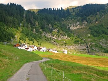
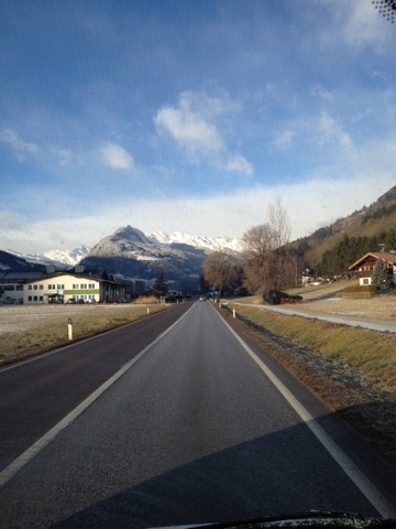
nudging right up against the houses and hotels of the neighbouring village - however the fact that so much of the venue is open to the elements rather than seeing the athletes swooping through the trees like in most of the Scandinavian, German and Russian venues, it introduces a couple of additional factors - firstly that the athletes can see their opponents much better than on a course through forestry where the same 'out of sight out of mind' principle that we see with regards to breakaways in cycling can be applied; and secondly, there's very little to prevent the wind from battering the athletes in the range. Fortunately for them the shape of the valley and the orientation of the range means that the heaviest winds are likely to be at the athletes' backs, but it does make the range quite a difficult one. At night throughout the winter the trails are lit, giving some majestic skiing opportunities to those willing to travel out to this remote corner of the country.

2015-01-15_156005c5baf40ff.jpg_image_scaler_800x0.jpg


In addition to the Nordic skiing and the biathlon venue, however, there's another reason for the area to stump up some funding, and that's to attract people to the Südtiroler Bergbaumuseum, the museum of the mining industry, which is a renowned tourist attraction. Also beyond this point is the Gilfenklamm, an attractive gorge-walk. The main body of the village where the finish would be located is based around a hotel resort and wellness spa, which markets itself around the 
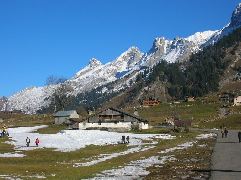
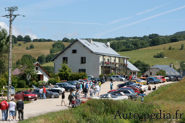
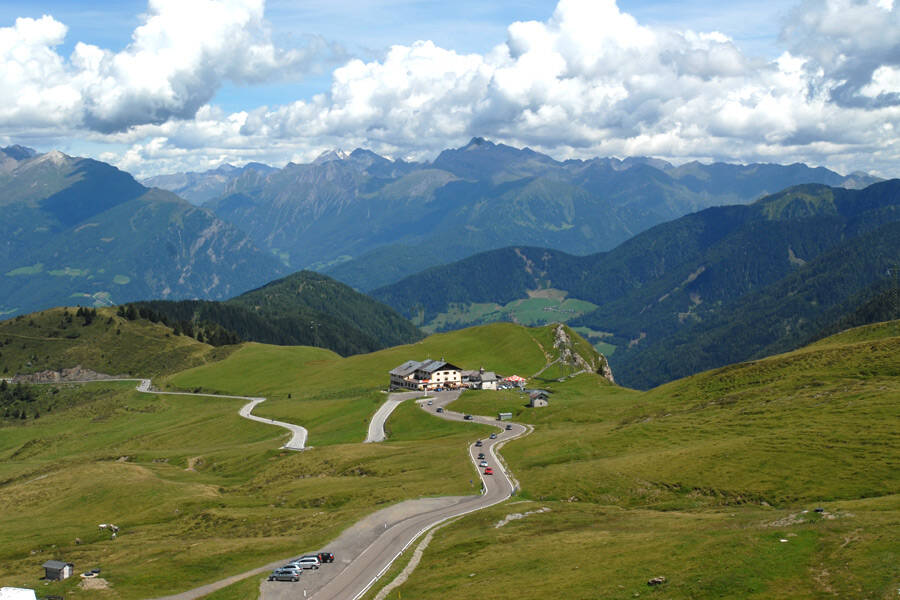
skiing possibilities, mainly as unlike the venues previously considered, in Ridnaun the village and the biathlon venue are kind of engaged in a mutually beneficial arrangement; the venue buildings are relatively small as spectators and athletes all walk up from the village or take shuttle buses from Ratschings or Vipiteno-Sterzing, because the distance is shorter than at many venues just getting from the entrance to the spectator points. Here you can see the whole arrival area, the village around the Schneeberg hotel and resort in the centre, with the initial parking area to the left of the road, where the finish will be, and the secondary parking area to the right of the road as it heads through the village, plus the additional space further down the road and across the river if required. The biathlon venue is to the left, with the shooting range clearly visible, and the Bergbaumuseum in the background at the end of the road leading out of the village away from the camera.

ridnauntal.jpg


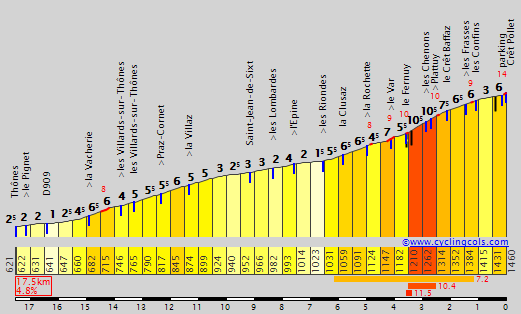
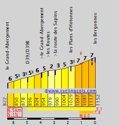
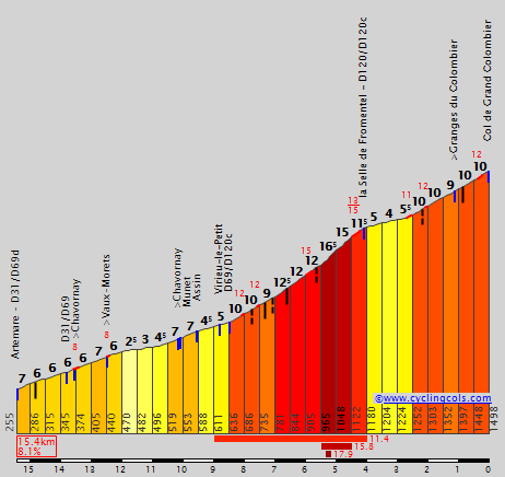
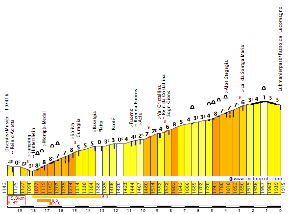
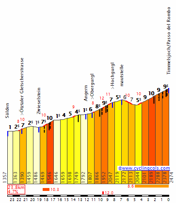
I've used the Ridnaun-Val Ridanna biathlon venue as a stage host in a race before, in my Giro del Trentino that was based entirely on Nordic skiing and biathlon venues. Railxmig described that particular design as being one of my best, so it should be little surprise that in some ways it has been reprised here. The Ridnauntal is greatly appealing from a traceur point of view because of the oddly-shaped nature of it, with a climb that ramps up for a short and steep ascent, but with a short flat run-in, which is very straight and can lead to a direct chasedown situation, but can be neatly appended to some very major ascents. The profile of the climb is thus:

Masseria.gif


Note that the climb here arrives all the way from Sterzing, which you would only be doing if arriving from the Brennerpass or the southern Wipptal (direction Pustertal). From the passes to the south you would only join the climb profile at Gasteig, while the stage finishing spot is the one marked "Maiern/Masseria" on the profile. Essentially, therefore, the stage finish is a climb of 3km at 10,3% before just under 4km of flat along a lonely and mostly straight road to the line. With the final climb being so tough you could have concerns that it would dissuade earlier action, so you need tough stages; but also, that final 4km drag race means you can't just open up a couple of seconds; and if you do open up small gaps, you've got the grimpeur's version of the Amstel Gold run-in to come.

blogger-image-270867191.jpg


The climb is of use to, obviously, the Giro d'Italia, linking to Italian cities as well as Austrian ones; it could then readily follow in the Giro as a killer mountain stage with an easier finale to follow on from a stage which has arrived in neighbouring Austria for a steep MTF, such as in 2011 with the Großglockner finish (of course the ideal would be the Rettenbachferner, though that may be difficult because of a) altitude and b) the proximity of the Passo Rombo to Ridnaun may limit choices. At the same time, a Rombo-Hochsölden finish followed by a stage from somewhere like Innsbruck, Imst or even Sölden itself could create some great opportunities, the only issue is how little space would then be being covered in the country by those two stages). The same formula could be of value to the newly rechristened Tour of the Alps. However, there's also the Österreichrundfahrt - while that race seldom ventures outside of its borders, and certainly not in recent years for a stage start or finish, the enormous German majority in the Ridnaun area and the cultural ties with the other parts of the Tirol could play a role in bringing the race in. In particularly remarkable circumstances you could see a multiple-country odyssey in a Giro weekend, as a stage from Italy through Switzerland to finish in Malbun, Liechtenstein wouldn't be an impossibility (and I do really like Malbun), followed by a stage from Vorarlberg (Vorarlberg and Liechtenstein seem to partner in sporting bids, from the European Youth Olympic Festival to the Alpine skiing) to re-enter Italy late in the day to finish at Ridnaun.

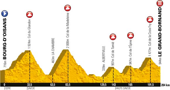
Stage proposal #1: Lago di Tesero-Val di Fiemme - Ridnaun-Val Ridanna, 203km

256v58k.png


The first stage proposal is essentially a revamped version of the stage I presented in my Giro del Trentino. That stage began in Trentino and looped around Fai della Paganella to begin, whereas here we start at the Lago di Tesero cross-country skiing venue, one of the most famous in the world, which was rebuilt recently to host the 2013 World Championships and serves every year as the final host for the Tour de Ski, with a distance classic race on the penultimate day including legendary short climbs such as Chiesa (so called because of the iconic church in the background) and Pojer followed by the coup de gras, a 9km pursuit race up to a mountaintop finish at the Alpe Cermis, a unique spectacle on the calendar, patterned after cycling. Slightly ironic, of course, that I've excised Fai della Paganella from the stage when it formed such a key part of the 2016 Andalo stage which has a finale similar in shape to this one, albeit with a much longer descent.

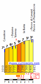
The second climb of my stage was also the key climb of that stage, and where everything was split up by the aggression of multiple contenders, though Ilnur Zakarin is the one I remember most from the opening salvos of that stage. Before they get there, however, they must crest the southern face of Passo Lavazè, under-categorized as is typical of the Giro. Indeed, that day Mendelpass (Passo della Mendola) was only given cat.2, but I've been a bit more generous, mainly because I couldn't really justify that being cat.2 and the ensuing Passo Castrin being cat.1 despite its final 9km @ 9%. The Hofmahdjoch (as it is called in German) is actually a relatively new pass in terms of its accessibility to traffic; until 1998, when the tunnel at the summit was completed, the first town on the southern side, Proveis, was part of Südtirol but only accessible via Trentino. The climb has actually never been used since that 1998 opening, although it was part of the mooted replacement stage in 2013 when the original Ponte di Legno - Val Martello stage via Gavia and Stelvio had to be scrapped; the compromise stage had the same start and finish but using Tonale and Castrin instead, however in the end the stage was cancelled altogether and run as originally planned a year later, where absolutely no controversy whatsoever was created.

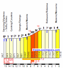
The main issue with this stage is that after the long descent from Castrin there's quite a lengthy respite in the valley after Meran before the main climb of the day from an action point of view, the Passo di Monte Giovo. This monolithic pass backs perfectly onto the Val Ridanna climb, and is an absolutely natural chain of climbs, in much the same way as the Citadel de Briançon naturally follows Izoard, Aprica naturally follows Mortirolo, or Ax-3-Domaines naturally follows Pailhères. They're climbs that go together too well to not link them. And, because the Ridnaun climb is short and you would typically expect there to be some pretty significant GC gaps by the time a Giro arrives in this part of the country, the fact that it crests just 27km from the line may tempt some action on this bona fide HC climb measuring 20km at 7%.

jaufenpass,273096330.jpg


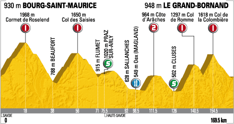
Stage proposal #2: Innsbruck - Ridnaun-Val Ridanna, 185km

epookk.png


This is the "kick it up a notch" version of the finish over Monte Giovo, moving from Austria into Italy via a series of killer climbs. As such, the altitude may make it risky for the Tour of the Alps, but it would be a perfect fit for them; it would also make a great Giro stage backing on from an Austrian mountaintop finish the previous day, though something like the Rettenbachferner would not suffice here given that going over Rombo means we would be retracing our steps pretty badly to do so. Maybe Kaunertal if the weather could allow for it, otherwise we might be talking something like Samnaun (although the actual summit's in Switzerland) or Serfaus. Going through the Felbertauern tunnel and finishing on Kitzbüheler Horn would be potentially doable, however...

Anyhow. This stage uses three cat.1 climbs before the finish, including setting the riders climbing straight away with an uncategorized climb around Axams before the long and grinding eastern face of the Kühtaisattel. Not seen from this side in racing since 2012, when 
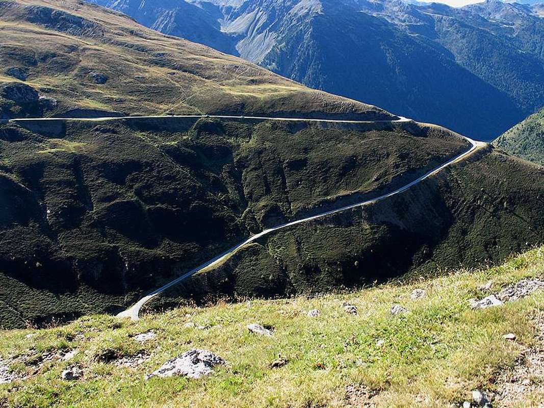
Kevin Seeldraeyers narrowly beat national champion Riccardo Zoidl on a mountaintop finish. Here it's an early leg breaker before a long drag up the Ötztal. In the 2005 and 2007 Deutschlandtours, this was a precursor to the Rettenbachferner, however here we're going with that monster's other natural partner, the Passo del Rombo. The problem is, coming from Austria, we have to use the easier side of the climb, because its southern face is an absolute killer - however we do get to use the harder side of Jaufenpass as a result. However, this side of the climb is ludicrously inconsistent which makes getting into a rhythm difficult - and also it has never been seen in pro cycling, as though the climb is scheduled to appear in the pro version of the Ötztaler Radmarathon, this is from the south face, and the one time it's actually been raced was in the 1988 Giro, where it was early in the stage from Meran to Innsbruck so not used in such a way as to make it GC-impactful.

RomboW.gif


Given that the Passo Rombo is at a whopping 2474m above sea level, I think this stage would work best in a Giro where Rombo is the Cima Coppi, as this will impact the racing on that particular climb, being as it is 75km from home. However, precious little of that 75km is flat; the first 30 is the technical descent from Rombo, and then there's no flat whatsoever before the start of Jaufenpass,with the same killer Jaufenpass - Ridnaun combination that was used in proposal #1.

Stage proposal #3: Trento - Ridnaun-Val Ridanna, 159km

2z4l08j.png


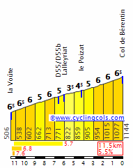
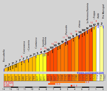
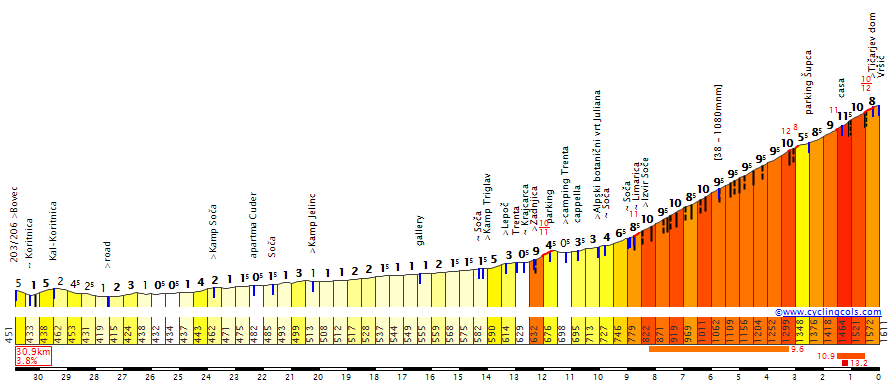
My third proposal here is a second all-Italian affair, and more of a medium-mountain affair that can produce a potential GC banana skin. It's designed to be a bit of a week 3 transitional Giro stage where they use key mountains but with the breakaway expected to play the main role, however trying to give the GC guys enough to work with that they need to remain alert and there could still be some action in the final kilometres. The Peio Terme stage in 2010 is a case in point. There's also cases like the Pfalzen stage Ion Izagirre won in 2013 or so, which was flat until the last; a stage flat until Ridnaun could resemble that but this gives us more opportunities because there are ambush possibilities built in to the stage. The stage also takes significant cues from the 1995 Val Senales stage won by Oliverio Rincón, which was also only the second time the Passo di Pennes was climbed in the Giro (the first was 1961).

1995-stage-profile-14.jpg


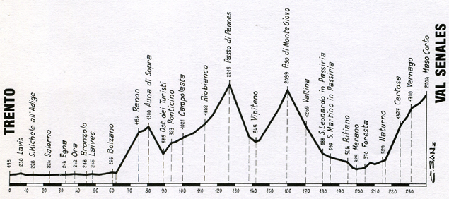
On first glance, the stage profile will resemble one of those pre-2008 Vuelta stage profiles, from the era where they used those horrible profiles with the inconsistent y-axis, stretching climbs out so they looked far flatter and longer than they were. For example, this was the profile for the 2007 Abantos stage (come to think of it, that belongs in the 'worst of race profiles' thread). Similarly, this was the Ávila stage - would it surprise you to learn that Abantos and Mijáres are not eternal 2-3% grinds with super steep descents? But here, it is true - I'm using much shallower climbs than the relevant descents of these climbs. Auna di Sopra is not actually that shallow from this side - 20km @ 5,3% although the first 12km are at around 6-7% - however because we're rejoining a valley road higher up and the first part of the descent is very steep, it looks quite insignificant by contrast. Similarly, the Passo Pennes is a monstrously hard ascent from the north, however its north face begins in Vipiteno-Sterzing, same as the climb up to Ridnaun, so we have the opposite side to climb, which is a very long drag that slowly reveals its difficulty as it gets higher and higher, ramping up the gradients until a final 4km at 9%. We're doing the final 36km of this profile, so you can see by the super-long profile this is more akin to, say, Sestrières from Pinerolo as a cat.1 climb than the kind of monster ascent like the other side of the climb. It does, however, crest 30km from home, so certainly if the break is taking this one it could be worth a speculative go from distance to get rid of any fugitivo who may be a threat in the sprint, or to see whose legs are ready for climbing should the group come back together on the descent.

222766.jpg


As well as being very dramatic, the descent is very steep - averaging nearly 9% for 14km - and includes a number of tricky switchbacks that will mean that if the group is sufficiently trimmed, some pressure could be put on the weaker descenders in the bunch, whether it be through a concerted group attack such as Movistar in Paris-Nice back in 2012, or through a dedicated specialist such as a Savoldelli or a Nibali pushing on in the hope of isolating or eliminating somebody who may have reason to be circumspect or who has a poor descending history. There's only a short flat period for them to utilize before the 3km @ 10% climb that leads to that sapping run-in to the line; when you're trying to chase on, little can be more sapping than getting to the top of a steep climb and then realising you don't get any respite, you've got to keep putting the power down and switch to TT mode.

Stage proposal #4: Sankt Anton am Arlberg - Ridnaun-Val Ridanna, 201km

6rukh5.png


This is the alternative, where we go full medium-mountain and present something that moves between Austria and Italy while presenting something akin to a hybrid between Liège-Bastogne-Liège and the Giro di Lombardia in profile, alternating short steep climbs with medium length and steep climbs. Obviously the profiling has been based on a Tour of the Alps/Österreichrundfahrt scale, as in the Giro d'Italia only two of those climbs would be categorized, just for the lols. This would probably be best served as a Tour of the Alps stage, as I'm not sure what kind of preceding stage could yield a start in Sankt Anton in the Giro (again - Serfaus? Samnaun? Maybe if we're super lucky, something like Stelvio then Sulden or Malles Venosta?) although if they went all out with a stage over Rombo and finishing at Hochsölden or Rettenbachferner, a stage starting in Sölden (it is a ski resort town, after all) would be able to cut about 25-30km off this stage and join it either at Imst (before Holzleitensattel) or at Telfs (before Möserer Sattel) to get the benefit of the rest of the challenges.

This one is all about small and difficult obstacles, and includes a number of them. The first really significant one will be Möserer Sattel, essentially 7km @ 8,5% and only used in that one Giro stage from 1988 mentioned above. The Austrian Nordic sports mecca of Seefeld, which hosted the Nordic events at the 1964 and 1976 Winter Olympics (save for the large hill ski jumping, which was at the iconic Bergiselschanze), has one of the most prestigious events of the Nordic Combined calendar every season, and will host the 2019 Nordic World Championships, lies just 4km from the summit of the climb, so you can be rest assured you'll hear more about it in this series - Seefeld offers some of the most varied sets of options of all, after all - and while I could have gone full-on and thrown in Silzer Sattel and Kühtai Sattel here, I'd still have been left with the same finale so it would have been a pointless addition of such a major ascent, other than to wipe out one group of potential stage winners.

B_seefeld_luftbild.jpg


After this we head into Innsbruck for a bit of a 2018 World Championships play-about, including the Hungerburg climb which was seen in the Tour of the Alps this season, won by Michele Scarponi from a small group, then the reverse side of the Patsch climb that has been in the mooted route, passing past the Igls bobsleigh run from the Innsbruck Winter Olympics. This road, at the summit of the climb with 63km remaining, joins after a period of rolling terrain onto the long and mostly false flat route up to the most famous crossing through the mountains between the two countries, the Brennerpass. However, this is supposed to be a hilly to medium mountain banana skin of a stage, so I've thrown in a little curveball in the form of the short, steep and narrow ascent up to the hamlet of Nößlach.

169eqv6.png


It's ridable, but because traffic on the Brennero makes it unwelcoming for cyclists outside of when it's closed for racing, many of these areas off of the main Brenner pass are not that well known to cyclotourists. This is essentially another climb of 3km @ 10%, along similar lines to Mende or the Alto do Malhão, 42km from the line. It's where the break may be, well, broken, if they're who are contesting it, and it's where you need to be shedding the opposition's domestiques if that's your aim too. After that, however, it's a gradual descent before the final 5km of the Brenner including that 1km @ 8,5%, the only severe ramp of the whole climb, cresting just before 30km from home. After that, it's a very fast descent - although as we're on the SS12 and haven't actually been on the Autostrada, there are some hairpin bends to consider, though compared to many roads the riders will take on these are fairly wide and inconsequential. That descent will deposit the riders in Vipiteno-Sterzing, ready for the final climb up to Ridnaun and then, once more, that painful final 4km of chasing into the finish.

It's a crying shame that Ridnaun doesn't host cycling. It's beautifully scenic, as we know from the biathlon (I actually wish they'd host higher level biathlon more often, to get more coverage from the site, as I like being able to see more of venues we normally only get summary videos from), and the possibilities are pretty great to produce some decisive racing here, without the easy way out that is a mountaintop finish. And indeed - as I'll show in some posts where mountain stages of any kind aren't really a possibility - you can do a lot more than just mountain stages with the Nordic venues, because they don't owe their raison d'être to the mountains, unlike their Alpine counterparts.
 
You don't need to remind me of Val Ridanna. Your Trentino stage from a couple of years back through Monte Giovo is stuff of legends. At first i thought it could be also a fine hilly/medium mountain finish after the Isarco valley and a small hill to Telves di Sopra but then the descent to Mareta (at the entrance to Val Ridanna) would be on an atrocious road so... If somebody doesn't care about roads the regular ascent to Telves di Sopra from Vipiteno is 3,5km at 8,8%. There is also an alternative on a smaller road known as Telferweg to nearby Telves di Sotto - it's 2km at 10%. This Telferweg road could be a fine edition if somebody's planning on using Monte Giovo and not wanting to finish in Val Ridanna. It could end in a descent finish in Vipiteno (Sterzing).

I wonder if i can add something substantial to Libertine's project but my knowledge of winter sports is very limited. Only winter sport i sometimes watch is ski jumping, so not even close to cross country or biathlon. In France i only know of Courchevel, but it doesn't need any introduction. There also seems to be a small ski jump in Chaux-Neuve in northern Jura, so i don't expect anything tough.

1. Chaux-Neuve

From Champagnole it would be a 20km at roughly 3% MTF (D127 & D437). There also seems to be a bit hillier alternative through Châtelneuf (D40 & D16) but it also does use parts of N5. In La Planches-en-Montagne i could leave the main D127 for D17 and then in Cerniébaud to go via D19. It's a bit hillier variant, but the steepest parts are at 7%, so nothing tough.

OJJMbrJ.png

Chaux-Neuve from Champagnole via Cerniébaud.

From Switzerland it looks better with Col de Landoz-Neuve and Col du Mont d'Orzeires roughly 17,5km from Chaux-Neuve. From Vallorbe the ascent to Col de Landoz-Neuve is 17km at 3%, but with a 1km at over 9%. From south Chaux-Neuve can be reached through Lac de Bellefontaine - 9km at 4,4% with last 15km to Chaux-Neuve on a plateau.

MSPgaPj.png

Montbéliard - Chaux-Neuve.

LandozNeuveE.gif

Col de Landoz-Neuve.

Bellefontaine.gif

Lac de Bellefontaine.

There seems to be a lot of variants available, but none of them seems to be particulary interesting. What else is there to do... Italy. There is Pragelato and Predazzo. I will focus on the 2nd one.

2. Predazzo

Predazzo is ideally in the middle of Val di Fiemme. Maybe Manghen with Passo di Pramadiccio could work better, but it still would be 16km from Predazzo with last 10km from Tesero in the valley.

PramadiccioW.gif

Passo di Pramadiccio.

I guess a much better try would be Passo Rolle as the descent goes straight to Predazzo. Passo Rolle is not the most difficult climb in the region but with either Cereda or Brocon it might hurt. Also, if there's Rolle there's also Valles and San Pellegrino. I guess the Marmolada circut can also be applied here.

0nYMM8L.png

Bassano del Grappa - Predazzo.

NW0pF3M.png

Belluno - Predazzo. Of course Pordoi and Fedaia are interchangeable.

Pk6Vk9I.png

Brunico - Predazzo. It slightly reminds me of a typical Iseran/Val d'Isère stage with Lautaret and Mont-Cenis.

9e5VvyV.png

Bassano del Grappa - Predazzo. Variant with Manghen.

3. Planica

For a long time the biggest ski jump in the world. However, a couple of years ago Vikersund took the title from Planica. Even after modernisation Planica is officially still just shy of Vikersund (difference of 2m - 251,5m vs 253,5m).

This one is easy. It's either a hilly stage through Tarvisio and Villach or Vršic. If somebody wants a monstrous MTF then nearby Mangart should be more than enough. Planica is mainly for a medium mountain stage. Vršic is roughly 20km from Planica with roughly 6km flat in the valley. The ascent to Planica should be a fine punchy affair with 2,2km at 4,5%.

VrsicS.gif

Vršic.

4. Štrbské Pleso & Králiky

Give me a couple of months and i'll tackle them. It's still unfinished though.
 
Chaux Neuve actually isn't that unknown, since it annually hosts the Nordic Combined World Cup.

I'm not sure if Libertine will also include towns which are only known for Ski Jumping, because if yes, I wouldn't be surprised if he also posts about Planica, since it's very famous and offers some great opportunities for cycling races. Oh and maybe there will be a post about Harrachov and how the cyclists could just climb the ski jumping hill :D
 
There will at some point (when I have enough time to write it, as it will take a long time) be a fairly lengthy post with several options (some of which you've pre-empted and some of which you haven't) around Lago di Tesero, which is the XC venue (also used for biathlon in the 2013 Universiade) for the Val di Fiemme, so appended to the Predazzo ski jump when they use it in the Nordic Combined. In the same vicinity there's also the punchy climb from the river into Cavalese that forms the final part of the Marcialonga. For some of the options Predazzo is preferable because it removes some of the run-in, for others Lago di Tesero or Cavalese is preferable.
 
Re:

Libertine Seguros said:
There will at some point (when I have enough time to write it, as it will take a long time) be a fairly lengthy post with several options (some of which you've pre-empted and some of which you haven't) around Lago di Tesero, which is the XC venue (also used for biathlon in the 2013 Universiade) for the Val di Fiemme, so appended to the Predazzo ski jump when they use it in the Nordic Combined. In the same vicinity there's also the punchy climb from the river into Cavalese that forms the final part of the Marcialonga. For some of the options Predazzo is preferable because it removes some of the run-in, for others Lago di Tesero or Cavalese is preferable.

I tried to use a muro to Carano and Daiano (just west of Cavalese), but going through Daiano would be a pain in the neck. If i'm not mistaken on the other side of the river there is Alpe Cermis. I think it's the last venue of Tour de Ski, where lads are going up a downhill slope. I guess it'll be a big staple on your Fiemme run. Also, i'm a big fan of Passo Manghen, so i guess there'll be a lot of it there.

EDIT: I don't know if Libertine will tackle Vercors, so i'm now looking at this Montagne de Lans/La Sierre station just above Villard-de-Lans with the very picturesque Col de la Machine. I'm not sure if something will come up with it but i do have a sketch of a potential stage finishing in this station.
 
Re:

meat puppet said:
Has anyone taken a shot at designing an LBL that 1) has La redoute as the last main climb and 2) packs more climbs between kilometers 100-220 than the current design thus making the mid section harder?

Cheers to all the contributors in this thread, it is awesome.

Here you are: http://www.openrunner.com/index.php?id=7301428
or here: http://www.openrunner.com/index.php?id=7248440

Rather similar of course.
I used La Redoute + Les Forges as final climbs, with a finish on the boulevard de la Sauvinère, as from the 1970's to 1991.
 
Re:

Netserk said:
An alternative finish, though with RaF as last major climb, but where Redoute should still play a bigger role:

I think the part between La Redoute and RAF should get harder. The problem is that it seems like people really want La Redoute to have a crucial role in the race but I think the race could be even better otherwise. One could ofc argue that hills between La Redoute and RAF will only make the route more backloaded but I think on a route as proposed by you there still wouldn't be that much happening on La Redoute

So what would you think about something like this. This is a route from La Redoute to RAF. From there on I'd use your route.
GgPBHu9.png


Edit: Maybe one could also skip Colonster (I think that last climb is Colonster)
 
Link to map? And how are the roads?

This is the last climb:
C%C3%B4te_de_Cortil_Tilff_profile.gif


The 15km you have before RaF are not much harder than the 15km in my version, while Redoute and the climbs before it (the hardest sector of the race, see rghysens' first route) are 18km further away from the finish. That said, I think it's nice :)
 
Re:

Netserk said:
Link to map? And how are the roads?

Colonster is the descent from RaF ;)
Colonster has different sides so you could descend RaF and still climb another one. The roads should all be usable the last ramp before RaF is on very narrow streets so it's debatable if you can use it. But the route wouldn't change much even if you don't include this climb. There is no street view for the climb before that but I found it on quaeldich.de and they didn't write anything about bad road surface so I suppose it's usable.

Anyway the first two relatively difficult climb after La Redoute are definitely usable. I can't post a map right now but I hope I'll find time today to do so
 
Re: Re:

rghysens said:
meat puppet said:
Has anyone taken a shot at designing an LBL that 1) has La redoute as the last main climb and 2) packs more climbs between kilometers 100-220 than the current design thus making the mid section harder?

Cheers to all the contributors in this thread, it is awesome.

Here you are: http://www.openrunner.com/index.php?id=7301428
or here: http://www.openrunner.com/index.php?id=7248440

Rather similar of course.
I used La Redoute + Les Forges as final climbs, with a finish on the boulevard de la Sauvinère, as from the 1970's to 1991.
Thanks, cool routes!
 

TRENDING THREADS