Race Design Thread

Page 275 - Get up to date with the latest news, scores & standings from the Cycling News Community.
Re:

Forever The Best said:
200+ km mountain stages with 5000+ m should be in every GT imo. As Riis says the one in '15 was too easy conpared to the one in '75 and it didn't bring big gaps for the first 4 GC riders of the stage (Quintana only finished 15 seconds ahead of Nibali) and I think a hardened version can bring better gaps.
The next stage though is just awesome. Sampeyre-Agnello-Izoard. :cool: Also using the unconventional side of Sampeyre is a nice change.
The total km of TTs looks a bit less for my liking though. It should have been around 100 km in my opinion since the second TT has some hills.
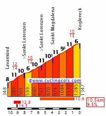
What I meant here was there should at least be one (perhaps even two or three) mtn stage that is 200+ km and 5000+m gained.
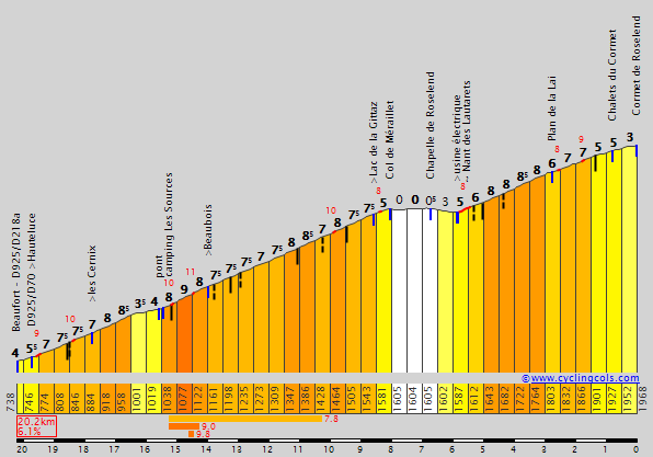
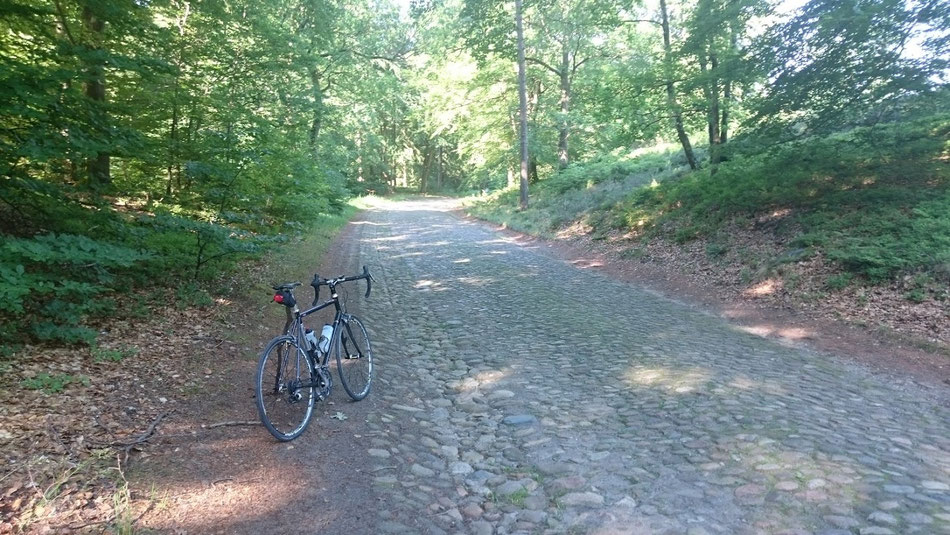
Also, I am designing a Vuelta which has 3 or 4 uphill finishes in the first week but 4 consecutive downhill finishes on the final week followed by a sterrato stage before the parade to Madrid. It will probably also have 100+ km of ITT but some of it is hilly.
 
Stage 20: Grenoble > Col des Aravis - 184km - high mountains
https://www.la-flamme-rouge.eu/maps/viewtrack/hd/133653
MmSQaqu.png

LXUBQJB.jpg

The last proper stage of this TDF offers one last opportunity to shake up the GC. This stage doesn't feature the hardest climbs in the world but all these smaller climbs add up to over 4800m of vertical gain. My goal for was to not make it too easy for riders to gain time on GC here to force attacks on stage 17 and 18, but still to offer an opportunity to make up time and move up after the stage 19 ITT. The first part of the stage has two 1st category climbs, the Col du Coq which is 7.2km long at 8.2%, and the Col de Champ Laurent, over 10km at 7.6%, which will weaken the legs of the riders and might serve to thin out the peloton. The final 65km are up and down all the way, with most notably the 2nd category climbs Col de Tamié, quite long but not too steep and Col de l'Epine, which is slightly shorter but steeper, and 1st category climb Col de la Croix Fry. This climb is quite irregular with some flat parts and even a very small descent but this means the climb is tougher than the average gradient would have you believe. Then, a short descent and ascent to the summit of Col des Aravis will follow. This isn't a very tough climb, 4km at around 6.5%, so for big gaps riders will have to attack earlier.

The climbs:
Col du Coq (1st Category, 933 m, 7.2 Km at 8.2%, Km 19.9)
Côte de la Chapelle-Blanche (3rd Category, 473 m, 4.1 Km at 5.1%, Km 51.8)
Col de Champ Laurent (1st Category, 1098 m, 10.6 Km at 7.6%, Km 78.9)
Col du Grand Cucheron (3rd Category, 1183 m, 3.9 Km at 7.4%, Km 85.8)
Côte de Saint-Georges-d'Hurtières (4th Category, 607 m, 1.4 Km at 6.1%, Km 96.9)
Col de Tamié (2nd Category, 913 m, 9.9 Km at 6.1%, Km 128.0)
Col de l'Epine (2nd Category, 944 m, 6.8 Km at 7.0%, Km 149.2)
Col du Marais (4th Category, 836 m, 2.2 Km at 4.3%, Km 158.8)
Col de la Croix Fry (1st Category, 1471 m, 11.2 Km at 7.3%, Km 175.3)
Col des Aravis (3rd Category, 1484 m, 4.1 Km at 6.7%, Arrive)

MargainsS.gif

Col du Coq

ChampLaurentW.gif

Col de Champ Laurent

TamieS.gif

Col de Tamié

Epine2S.gif

Col de l'Epine

CroixFryW.gif

Col de la Croix Fry - final 11km

AravisN.gif

Col des Aravis - final 4km

fkK2YZv.png

Col de Champ Laurent

k3LqxqA.jpg

Col de l'Epine

WqvXG68.png

Col de la Croix Fry - as you can see, pretty wide roads and good tarmac on all these climbs

uYCtbSX.png

Col de la Croix Fry descent

MCAmduu.png

yTTYKG3.png

Col des Aravis, great scenery

hnWSnSG.png

Finish area at the Col des Aravis summit


Stage 21: Fontainebleau > Paris - 107.5km - flat
https://www.la-flamme-rouge.eu/maps/viewtrack/hd/133654
MGbsM66.png

zAbGbBr.png


Not much to say about this stage - it's the classic ceremonial parade into Paris with a sprint finish on the Champs-Élysées. I stopped at 5.5 laps on the circuit, mainly because I got bored, but you can do however many you want of course :cool:

kH6eSrh.png

champs-elysees-tour-de-france-cycling_2963735.jpg
 
Tour de France final summary
3NskNf9.png

https://www.la-flamme-rouge.eu/maps/tours/view/5980

1: La Roche-sur-Yon > La Roche-sur-Yon 13.5km
20px-Time_Trial.svg.png
TTT
2: La Roche-sur-Yon > Angoulême 187km
22px-Plainstage.svg.png

3: Périgueux > Aurillac 190.5km
22px-Plainstage.svg.png

4: Issoire > Villefranche-sur-Saône 184km
22px-Mediummountainstage.svg.png

5: Besançon > Côte du Gaschney 192km
22px-Mountainstage.svg.png

6: Saint-Dié-des-Vosges > Mulhouse 185km
22px-Mediummountainstage.svg.png

7: Vesoul > Mâcon 215km
22px-Plainstage.svg.png

8: Saint-Étienne > Aix-les-Bains 190.5km
22px-Mountainstage.svg.png

9: Valence > Mende 225km
22px-Mediummountainstage.svg.png


Rest day

10: Le Mans > Niort 209km
22px-Plainstage.svg.png

11: Royan > Marmande 199km
22px-Plainstage.svg.png

12: Bayonne > Bayonne 24.5km
20px-Time_Trial.svg.png
ITT
13: Pau > Superbagnères 208km
22px-Mountainstage.svg.png

14: Saint-Gaudens > Carcassonne 227km
22px-Mediummountainstage.svg.png

15: Narbonne > Ax-les-Thermes 182km
22px-Mountainstage.svg.png


Rest day

16: Montpellier > Aix-en-Provence 193km
22px-Plainstage.svg.png

17: Digne-les-Bains > Pra Loup 176km
22px-Mountainstage.svg.png

18: Cuneo > Briançon 166.5km
22px-Mountainstage.svg.png

19: Grenoble > Grenoble 44km
20px-Time_Trial.svg.png
ITT
20: Grenoble > Col des Aravis 184km
22px-Mountainstage.svg.png

21: Fontainebleau > Paris 107.5km
22px-Plainstage.svg.png

(I stole mikii's wee little icons :) )

Total distance 3504km

7 "flat" stages
4 "medium mountain" stages
7 "high mountain" stages
2 ITT
1 TTT

Total individual TT km: 68km

5 uphill finishes
Côte de Gaschney (cat 2) stage 5
Côte de la Croix Neuve (cat 2) stage 9
Superbagnères (HC) stage 13
Pra Loup (cat 2) stage 17
Col des Aravis (cat 3) stage 20

7 high mountain stages
4 with uphill finish (Gaschney, Superbagnères, Pra Loup, Aravis)
Downhill finish after Mont du Chat (HC) stage 8
Downhill finish after Port de Pailhères (HC) stage 15
Downhill finish after Izoard (HC) stage 18

6 HC climbs
Mont du Chat (st 8)
Superbagnères (st 13)
Port de Pailhères (st 15)
Colle di Sampeyre, Colle dell'Agnello, Col d'Izoard (st 18)

10 cat. 1 climbs
Ballon d'Alsace, Col du Grand Ballon (st 5)
Col de Menté, Col du Portillon (st 13)
Col de Péguère (st 14)
Col du Garabeil (st 15)
Col d'Allos (st 17)
Col du Coq, Col de Champ Laurent, Col de la Croix Fry (st 20)
 
THIEF!!!! joking, it's alright, I don't mind :D :D

I really like your route, though I'm not sure how the first weekend will go - I have a weird feeling that both stages will be soft pedalled, save for Mont du Chat. The stage to Aravis is, on the other hand, a monster, but I love those :D well done!
 
Re:

mikii4567 said:
THIEF!!!! joking, it's alright, I don't mind :D :D

I really like your route, though I'm not sure how the first weekend will go - I have a weird feeling that both stages will be soft pedalled, save for Mont du Chat. The stage to Aravis is, on the other hand, a monster, but I love those :D well done!
Thanks :) yeah, it's always a bit of a guess how each stage will be raced. The order Chat - Mende - rest day has the biggest possibility of success I think :p
 
Re:

LaFlorecita said:
Tour de France final summary
3NskNf9.png

https://www.la-flamme-rouge.eu/maps/tours/view/5980

1: La Roche-sur-Yon > La Roche-sur-Yon 13.5km
20px-Time_Trial.svg.png
TTT
2: La Roche-sur-Yon > Angoulême 187km
22px-Plainstage.svg.png

3: Périgueux > Aurillac 190.5km
22px-Plainstage.svg.png

4: Issoire > Villefranche-sur-Saône 184km
22px-Mediummountainstage.svg.png

5: Besançon > Côte du Gaschney 192km
22px-Mountainstage.svg.png

6: Saint-Dié-des-Vosges > Mulhouse 185km
22px-Mediummountainstage.svg.png

7: Vesoul > Mâcon 215km
22px-Plainstage.svg.png

8: Saint-Étienne > Aix-les-Bains 190.5km
22px-Mountainstage.svg.png

9: Valence > Mende 225km
22px-Mediummountainstage.svg.png


Rest day

10: Le Mans > Niort 209km
22px-Plainstage.svg.png

11: Royan > Marmande 199km
22px-Plainstage.svg.png

12: Bayonne > Bayonne 24.5km
20px-Time_Trial.svg.png
ITT
13: Pau > Superbagnères 208km
22px-Mountainstage.svg.png

14: Saint-Gaudens > Carcassonne 227km
22px-Mediummountainstage.svg.png

15: Narbonne > Ax-les-Thermes 182km
22px-Mountainstage.svg.png


Rest day

16: Montpellier > Aix-en-Provence 193km
22px-Plainstage.svg.png

17: Digne-les-Bains > Pra Loup 176km
22px-Mountainstage.svg.png

18: Cuneo > Briançon 166.5km
22px-Mountainstage.svg.png

19: Grenoble > Grenoble 44km
20px-Time_Trial.svg.png
ITT
20: Grenoble > Col des Aravis 184km
22px-Mountainstage.svg.png

21: Fontainebleau > Paris 107.5km
22px-Plainstage.svg.png

(I stole mikii's wee little icons :) )

Total distance 3504km

7 "flat" stages
4 "medium mountain" stages
7 "high mountain" stages
2 ITT
1 TTT

Total individual TT km: 68km

5 uphill finishes
Côte de Gaschney (cat 2) stage 5
Côte de la Croix Neuve (cat 2) stage 9
Superbagnères (HC) stage 13
Pra Loup (cat 2) stage 17
Col des Aravis (cat 3) stage 20

7 high mountain stages
4 with uphill finish (Gaschney, Superbagnères, Pra Loup, Aravis)
Downhill finish after Mont du Chat (HC) stage 8
Downhill finish after Port de Pailhères (HC) stage 15
Downhill finish after Izoard (HC) stage 18

6 HC climbs
Mont du Chat (st 8)
Superbagnères (st 13)
Port de Pailhères (st 15)
Colle di Sampeyre, Colle dell'Agnello, Col d'Izoard (st 18)

10 cat. 1 climbs
Ballon d'Alsace, Col du Grand Ballon (st 5)
Col de Menté, Col du Portillon (st 13)
Col de Péguère (st 14)
Col du Garabeil (st 15)
Col d'Allos (st 17)
Col du Coq, Col de Champ Laurent, Col de la Croix Fry (st 20)
Really like your Tour flo. Feasable, pretty balanced, and a nice blend of really big mountains and some intermediairy ones. Placement of the main climbs seemed great mostly. It's the kind of route where it's easily possible to throw with minutes, they're not given at the end of the hard stages.

The only disbalance I could possibly see is that the long TT may be a bit too hilly and so gaps stay a bit close, but having 2 TTs should help

Don't really like a TTT to start though :p
 
Deutschland Rundfahrt, 4. Etappe: Weiden in der Oberpfalz - Grosser Arber: medium mountains, 150km

A 60km transfer brings the race caravan from the finish of stage 3 to the start of stage 4.

Y460hZm.jpg


Weiden in der Oberpfalz is a medium sized bavarian town, close to the border with the Czech republic.

800px-Weiden_Oberpfalz_22_Mai_2016_01.JPG


The whole stage will run more or less parallel to this border, with the finish only a couple of kilometers from the border. The first 40km are on generally rolling roads, with several uncategorised and one categorised climb. None of them are difficult, but the elevation gain of 700m in the first part of the stage may see a strong breakaway go clear. The middle part, fifty more or less flat kilometers will probably mean a status quo in the course development. The crossing of the Weisser Regen river in Bad Kötzting sees a change in terrain: no more flat or rolling roads, but some rather steep, but short climbs. While the course winds its way through the Bayerischer Wald, the first mountain pass (albeit a not too difficult one) of the race is crested. The Eck (or Ecker Sattel) snakes between the summits of the Kleiner Riedelstein and Mühlriegel to an altitude of 843m.

PXy2u50.jpg


Its descent and 10km uphill false flat lead to the main difficulty of the day: the climb on the Arberstrasse, to the summit of the Hahnenriegel. This irregular climb delivers the first opportunity for the climbers to make up for time lost in the first two stages. The first three kilometers of this climb have sustained sections of nearly 10%, with a maximum of 19%.

33BlEOR.jpg


The short descent leads to a final, uncategorised bump of 2km @ 5%, that ends with 1.5km to go. The finish is near the wintersport facilities on the slopes of the Grosser Arber, the highest peak of the Bayerischer Wald.

800px-Gro%C3%9Fer_Arber.jpg
 
Oct 4, 2015
417
1
3,030
Tour de France Stage 18: Annecy - Arc 1800, 204km
b7qUGAq.png

rOnNHUl.png

Climbs: Romme (cat. 1), Colombière (cat. 1), Aravis (cat. 2), Saisies (cat. 1), Pré (cat. 1), Cormet de Roselend (cat. 3), Arc 1800 (cat. 1)

Right after the time trial we get another insanely hard mountain stage, featuring the final summit finish of the race. There are seven categorized climbs, five of which are cat.1 climbs (two of them, Romme and Pré, are borderline HC climbs), for a total elevation gain of about 5600m. From the foot of the first climb 51km into the stage to the finish of the 204km stage there's essentially no rest to be had.
The stage starts off easy, with 50km of warm-up until Cluses, where riders take on the first two climbs of the stage, the relatively short but very steep climbs of Romme-Colombière (only the last 7.5km for the latter). While they come too early on the stage for attacks to be made (and, with the sheer difficulty of the stage, attacks shouldn't be expected until much later), their very steep slopes should be plenty enough to break the main group apart. Riders looking for the stage win will likely try and form a breakaway here as well.
RommeN.gif

ColombiereN.gif

After Colombière we have the climbs to Aravis (last 12km only) and Saisies, much shallower than Romme-Colombière, but with practically no flat in between. Anyone that falls off the pace in the first climbs will have little if any chances to catch up without wearing themselves down... and any energy wasted catching up here will be paid for later.
AravisN.gif

SaisiesN.gif

4 climbs down, 3 to go. And the next climb is the hardest one in the entire stage.
The Col du Pré is a side ascent to the better-known Cormet de Roselend, connecting Beaufort and Bourg-Saint-Maurice. It's also a very steep climb, with its final 7km constantly around 10%. With four climbs already on the legs, any remaining groups will likely fall apart here. Only the GC contenders (and possibly stage-chasers on the breakaway) should remain at the front; this may very well be the chance for the endurance climbers to try and catch their opponents offguard, with no more teammates to cover them. Hopefully...
PreW.gif

After Pré there's a bit of a rest zone, followed by the final 5.5km of Roselend, ranked independently as a cat.3 climb. This also happens to be the easiest climb of this stage
RoselendW.gif

Finally, after a long descent intercalating technical sections and long straights, we reach the foot of the final climb: Arc 1800. A long and very regular climb, with gradients around 6-7%. Not the best climb to get gaps on, but it's still going to hurt weaker riders a lot.
Arc1800.gif

After this, the GC classification should be almost settled. While we may not see too many flashy attacks (there's always the chance for a suicidal attack at Pré... or maybe the riders all decide to make this an 8-hour cyclotour of the Alps), it's likely we'll see several riders sink under the pressure anyway. There's still two more chances for surprises after this stage, though.
 
DACH Rundfahrt stage 9: Hildesheim - Lüneburg (236 km)
category: flat stage
KlmBLA1.png

DbvoqXh.jpg


The last DACH Rundfahrt stage of the first week, which is btw also the last one completely in Germany, is another flat one, but don't let you fool by the very little climbing, since this stage will be hard for a different reason, cobbles. Before I write more about this stage, just want to mention that I used old stages posted in this thread to find cobbles in this part of Germany. Therefore special thanks to Libertine who used these sections before, hope it's not a problem for you that I use them as well.

The stage starts in Hildesheim.
marktplatz-hildesheim-iii-2cf21810-8008-4dd1-ab51-c55fc501d900.jpg


Shortly after the start there is a short climb to the castle Marienburg which isn't quite hard enough for categorization but still the organizers would surely be happy about some nice camera pictures of this incredibly beautiful castle.
promstmarienburg.jpg

The following 100 kilometer aren't exactly spectacular and except for an intermediate sprint in Hannover there won't be any highlights. Then however the cobbles start with the first sector in Kirchlinteln. This is actually not one cobbles section but two very short ones directly after each other.
009145_0371bdfd.jpg

009132_fb70fa2a.jpg


To be fair I wouldn't expect too much to happen here but the pace will probably be high, crashes can always happen on roads like that and since nobody will want to be caught behind a split there will surely be a fight for positions. Moreover less than 10 kilometers later there is already the next sector, the Mühlenweg.
096692_5f5ca8f1.jpg

This sector again isn't very long, with only slightly more than a kilometer, but due to the very bad surface teams will again be alert.
After this cobbled street the race will calm down a bit until rider arrive in the little village Döhle. Here the longest stretch of cobbles, an over 8 kilometer long sector starts. However again there will be a bit of tarmac between basically two sectors but since this tarmac stretch is only a few hundred meters long I decided to call this one sector.
From now on the race will completely depend on how aggressive teams are. Is there a gc contender who is good on cobbles who has somehow already lost a lot of time, then he might try to make this sector as hard as possible. If classic specialists are worried about sprinters they might attack here as well and if it rains there will probably be carnage anyway. If the race situation is right the race might completely explode here and there could be crucial time gaps.
2.-Foto_930x400.jpg

image.jpg


Before the final cobbles sector of the day starts there is the golden kilometer which will hopefully be another motivation to already make the race hard a bit earlier.
The last cobbled stretch goes from Putensen to Kirchgellersen. If there is still a big peloton it's at least almost certain that riders will try to make the race hard here either by attacking or by trying to make the race hard for pure sprinters. The sector is 4 kilometers long and is over around 11 kilometers from the finish (the profile isn't accurate since I made the starting point of the sector a bit too early) and the cobbles are under a lot of dust, so you could almost call this a dirt road
The stage finishes in Lüneburg.
LgL3lA3.jpg
 
Aug 4, 2017
3
0
0
I created my own tdf 2018 route, it's maybe a bit unrealistic but hey, it's for fun

The first 3 stages are already announced , so I started from stage 4


cqfcrxz.png

TTgo42d.png

7l9kNr0.png

D5d8Ile.png

XHLbIPF.png

tbbySuU.png

azdN9dQ.png

uGko9iL.png

U0bftkm.png

sqzEg1d.png

nREgDUs.png

OawLImU.png

mrqDf0P.png

V6hVffi.png

OPV18gh.png

FSLpLDK.png

Rd4ScMs.png
 
DACH Rundfahrt stage 10: Köflach - Koralpe (192 km)
category: high mountain stage
NDk7AgC.png

35jduQj.jpg


On the first rest day the riders fly from northern Germany to Austria, where they spend their first rest day in Graz. But they better don't break there racing rhythm too much because what awaits them on stage 10 is probably the queen stage of the DACH Rundfahrt. When I started posting this race I mentioned that I wanted to use some rather unknown climbs in Austria which are basically never used in the Österreichrundfahrt and are too far away from Italy, Switzerland and Germany to get used in the respective national tour. But let's start with the first climb which is actually the only one which has been used in the Österreichrundfahrt not that long ago. Directly after the start in Köflach the Packsattel starts, a 2nd category climb which consists of two short ascents with a flat section between the two. It was used in the 2015 Österreichrundfahrt on a stage to the Dobratsch won by the later winner of the gc Victor De La Parte in front of Jan Hirt.
PackN.gif

After the descent the riders arrive in Wolfsberg, where the only intermediate sprint of the stage takes place. The next almost 30 kilometers are flat but thats the calm before the storm since then the first HC climb of the Rundfahrt starts, the Soboth or also called Koglereck.
KoglereckW.gif

As you can see the climb isn't long but brutally steep with an average gradient of around 10%. The climb comes far away from the finish and there are still lots of flat kilometers left so nothing will happen here but that said, climbs like this will hurt the riders and make the finale of the race even more brutal than it would be anyway.
286560.jpg


After the descent the riders face, as I already mentioned, a long flat section with the golden kilometer in Deutschlandsberg at the end of this stretch. Here the contenders for the green jersey who went into the break will sprint for points. Then the 2nd HC climb of the day starts, the Weinebene. Like the Packsattel this climb consists out of two parts. It begins with 5 brutally steep kilometers (around 11% steep), followed by a short descent and then a 12 kilometer long uphill drag which is 6% steep. I think a climb like this would be very interesting as a mtf late in the race since it will motivate riders to make the race hard early, however in this case it's used as the penultimate climb. I have to admit 12km @ 6% won't exactly motivate riders to make long range attacks, but then again this is the first high mountain stage, and also, just look at the last climb. Nobody will be stupid enough to try a long range attack at this point of the stage, no matter how the penultimate climb looks like.
WeinebeneE.gif

1wuarPs.jpg


After a descent and 9 flat kilometers the riders face that final climb of the day, the Koralpe. With 11.1km @ 10.5% this is probably the hardest climb of the whole race and as the first mountain top finish at the end of such a brutal stage there would probably be carnage. You better don't have a bad day on this stage because you could lose minutes. I think even a scenario in which nothing really happens because everyone is already tired is rather unlikely since the steepness of this climb should automatically make the peloton explode.
Koralpe.gif

24.520.080

By the way, the road doesn't even end here. You could ride on to the Großer Speikkogel, one of the most brutal climbs in Europe.
Stage 10 is where the battle for the gc really starts. Ofc there were already an ITT, a cobbles stage and an uphill finish where some gc contenders might already have attacked, but this is the day on which you can't hide anymore. On this day you have to be at your best or you are already out of the battle for the gc.
 
DACH Rundfahrt stage 11: Klagenfurt - Turracher Höhe (190 km)
category: high mountain stage
NsmsMeK.png

kpELWEY.jpg


After the queen stage on stage 10 the race continues with the 2nd brutal mountain stage in a row. The start of the stage is in Klagenfurt, capital of the stage Kärnten and located at the beautiful Wörthersee.
header_die%20Stadt2014korr1-703x318.jpg


The stage starts rather easy. There is a 4th category climb after 39 kilometers but that ascent will probably rather have an impact on the points classification than on the mountain classification since guys like Matthews or Sagan will try to drop their rivals like Kittel or Cav here to drop them before the intermediate sprint 10 kilometers later in St. Andrä. Then the real difficulties start with the pretty unknown 1st category climb to the Klippitztörl.
KlippitzSE.gif

SWsbiO7.jpg


This climb doesn't have a very high average gradient, but as you can see it's pretty irregular and therefore harder than it seems. Especially the 4 km long stretch at over 10% will hurt. After this climb the stage eases off a bit and there is another intermediate sprint in St. Veit an der Glan. After almost 140 kilometers however the road starts going up again with the 2nd 1st category climb of the day the Simonhöhe. This climb alone ins't anything special, but it's the fact that from here onwards the stage is basically only uphill or downhill. Said differently from this point onwards it's basically also possible to attack everywhere. However considering how far away we are still from the finish and that this is only stage 11 I wouldn't expect attacks so early.
SimonhoheS.gif


After the descent there is a little uncategorized climb before the next cat.1 climb starts, the Hochrindl. This could be where the race explodes, after all the riders will still feel the queen stage in their legs and so far this stage has also already been quite hard. Riders could already get difficulties to stay in the peloton if they have a bad day and since the following stage won't be very hard a gutsy rider who already has to make up time could give it a go and try to get away.
08Weitblick_bis_Slowenienkl.jpg
12Sch__n_angelegte_Kehrenkl.jpg

HochrindlSE.gif


I put the golden kilometer after the final descent of the stage to encourage attacks on the penultimate climb. However if nothing has happened yet this could still become a good stage because the final climb is hard enough to create some serious time gaps. It's the Turracher Höhe, a pretty steep, but not very long climb which is therefore "only" first category. The hardest part of this ascent is quite famous as one of the steepest streets in Europe with a gradient of 23%. Fortunately this section is in the middle of the climb and not at the end which means that even if everyone decides to wait for this stretch to attack we don't get an Peyragudes like borefest. The riders reach the highest point of the Turracher Höhe a few hundred meters before the finish, since the finish line will be located in the centre of the ski area at the top of the pass.
vakantie.JPG

TurrachS.gif
 
Deutschland Rundfahrt, 5. Etappe: Passau - Spitzingsee: 207km, medium mountains + mtf (sort of)

An 80km transfer brings the race caravan from the mountains on the German/Czech border to a quintessential German town on the border of Germany and Austria: Passau.

gPMqxDL.jpg


Being on the confluence of the Danube, Ilz and Inn, Passau is known in German as Dreiflüssestadt ("three rivers city"). Its old town contains a lot of historical buildings, making it a popular tourist destination.

799px-Passau_Panorama_080420_2.jpg


The course itself remains for more than 150km on the plains of the Inn river before the first climb of the day is tackled. The short but steep climb to Steinkirchen shows some similarities with the more Côte de Croix-Neuve in Mende. With 3.2km @ 9.6%, it's a bit longer, but slightly less steep.

x90TVJ3.jpg


Its descent leads to the Inn, which is crossed at Tiefenbach. Once the town of Brannenburg is left behind, the second climb in this stage starts. The Sudelfledpass is long and irregular, but consists mainly of prolonged stretches false flat, interrupted by some steeper stuff.

Mx7nLRr.jpg


The short but steep descent is followed by 10km on a plain, before the final climb kicks in. The Spitzingsattel has stats that are a bit harder than those of the Col de la Croix or the Col de Chevrères and is very close to the finish, so I'm giving it a cat1 rating, although a cat 2 might be more appropriate.

6GNSn2H.jpg


The summit of this climb is at the 1km to go banner, a false flat descending final km that leads to the touristic infrastructure hemmed between the lake and the mountains.

800px-Bavaria_Spitzingsee_from_Rosskopf.jpg
 
Deutschland Rundfahrt, 6. Etappe: Bad Tölz - Friedrichshafen: 198km, flat

The first five stages only saw one stage suited to sprinters. In order not to upset (German) sprinters, there's stage 6. No categorized climbs, no cobbles, probably no wind.

LxXC5NK.jpg
 
DACH Rundfahrt stage 12: Murau - St. Johann Alpendorf (112 km)
category: medium mountain stage
9m9g1YH.png

nhTOpjV.jpg


After two brutal mountain stages the riders face a very short medium mountain stage. The start is in Murau, located at the river Mur and home of one of the best breweries in Austria.
murau_kreischberg_sommer.jpg


The first 50 kilometers of the stage could be pretty fast, since there are intermediate sprints after 21 and 36 kilometers in Predlitz and Tamsweg. I know, two intermediate sprints so close after each other and also so early in the stage are something quite unusual, however I think this might lead to sprinter teams trying to keep the race together. This could be interesting since there is a quite hard 2nd category climb starting less than 20 kilometers later. Which could mean that the break will form on this climb quite late in the stage, and then that would mean a very high pace on that one climb. This should cause an interesting break and theoretically the peloton could split here and we could have an ambush scenario. To be fair very unlikely but who knows. Hardly ever we have big surprise attacks on really hard climbs but climbs which are hard enough to make a difference but easy enough to get underestimated by gc contenders who aren't positioned well and are suddenly caught when riders at the front push on. Stages on which that kind of stuff happens (Formigal, or Piancavallo stages are good examples) are usually the kind of stages where nobody expects anything to happen before the last kilometers.
The climb I'm talking about the whole time is Obertauern, a pass which was used in the 2014 Österreichrundfahrt, but from the other, harder side.
TauernS.gif

Obertauern-im-Sommer.jpg


After a long descent the riders arrive in Radstadt where they will ride the Golden Kilometer. Hopefully this could be another motivation to attack, though more likely for stage hunters who fight for the points competition than for gc riders who fight for bonus seconds.
While the first part after the descent from Hohentauern was flat, that flat section stops with around 27 km to go, but not because of another climb but because of a false flat descent which could help the break to stay away. The last two kilometers however will not be in their favor since the road rises again and the riders climb to St. Johann Alpendorf. This ascent isn't very difficult but it's still one of the most famous ones in the Österreich Rundfahrt where it gets used almost every year. In 2012 Jakob Fuglsang finished his crazy 100 kilometer solo ride here and only around one month ago Ben O'Connor won here in front of Riccardo Zoidl, while Stefan Denifl could defend his overall lead to win the general classification.
So since for Austrian circumstances this is a place with comparably much pro cycling history I thought it would be fitting to finish a stage here. Moreover I generally like relatively easy uphill finishes like this one and there hasn't been one in this race. The stage will either go to a strong puncheur or to the break. In any case I think this should be a stage worth watching despite not being a mountain stage.
alpendorf-1.jpeg
 
DACH Rundfahrt stage 13: Zell am See - Landeck (222 km)
category: flat stage
2bOfW9U.png

anlX2ij.png


A flat stage in this part of Austria? Thats like a flat stage in the Aosta valley, nobody would ever do that, right? Well apparently I do that, because this part of Austria is actually quite annoying for race designing. The problem is that if you want to make a race where you use the absolute west of Austria you always have to make a stage in the Inntal, and after making lots of races partly in the west of Austria I don't want to use the same climbs all over again and instead just made this stage flat. The start is in Zell am See.
zellamsee_sommer1.jpg


The first 80 kilometer are actually quite hilly. There are no categorized climbs but while the athletes ride through Saalfelden and St. Johann in Tirol there are hardly any really flat kilometers. After the intermediate sprint in Wörgl however the road flattens out. While the riders ride alongside the scenic Nordkette there will be another intermediate sprint in the capital of Tyrol and the hosting city of the WC 2018, Innsbruck.
innsbruck-tirol-202mo.jpg


After around 170 kilometers the only climb of the day starts, the long but flat Holzleitensattel. This climb maybe looks harder than it is due to the pretty big elevation gain, but due to the high gradient I think this stage is still a good opportunity for sprinters considering climbs like this usually don't prevent a bunch sprint. Examples for this would this giro stage won by Greipel or this tour de france stage won by Cav and I'm sure there are many more. That said, this ofc gives attackers an opportunity to get away or sprinters who can climb well could take the chance to drop pure sprinters. Moreover the golden kilometer in Imst shortly after the climb could be another motivation for the likes of Sagan, Matthews or Degenkolb to put pressure on the likes of Cav or Kittel on this pass. The finish of the stage will be in Landeck.
D_Landeck_Sommer.jpg
 
Finally back with my race in Cape Town. Here's a recap of the previous stage

Cape Town and West Cape International Cycle Stage Race Stage 4: V&A Waterfront - Signal Hill (184km)

FHrOLpG.png


myyMxNb.png


Climbs:
Red Hill Road @ 83.5km (5.2km @ 4.8%)
Ou Kaapse Weg @ 119.5km (4.5km @ 6.0%)
Rhodes drive @ 147km (6.3km @ 3.4%)
Signal Hill @ 184km (HTF) (7.6km @ 4.2%)

Sprints:
Hout Bay @ 141km
Buitengracht Street @ 167km

Feed zone:
Kommetjie @ 97km

The queen stage of the CTWCICSR is upon us. The riders will head out as from the V&A Waterfront again and head south along the Victoria Road and Chapmans Peak Drive to Kommetjie via Hout Bay. This will take the riders into a loop that features the Red Hill Road climb from stage 3.
After that loop, the riders retrace their steps, skirting round Kommetjie the feed zone. This takes the race onto some rolling terrain, before the second categorised climb of the day, the Ou Kaapse Weg. Again, this loop is followed by retracing the steps of the stage and heading through Hout Bay again for, but this time, for the intermediate sprint. Then the riders hit the Rhodes Drive climb, which is confusingly mainly Hout Bay Road. However after taking in another uncategorised climb as the riders skirt the bottom of Table Mountain. Next is the sprint on Buitengracht Street in Cape Town itself, follwed by the race spirallaing round the bottom of the final climb of the day to take the riders to camps bay.
This is where the final climb starts; right on the sea front of the suburb. After about a kilometre, the riders enter a long left hand bend that loops the riders round to head for the direction of the top. With 3km done, the average gradient raises to nearly 7% for 2km. But then after arriving at a junction with the road to the summit, the city centre and the Tafelberg road the riders have a short bit of down hill before the race ramps up to an easier 4% gradient towards the hairpin that brings the riders to the top of the hill. From here the gradient is an even easier 2% incline to finish off with, aswell as spectacular views of the City and Table Mountain. So, overall a very rolling stage with a summit finish overlooking the city.

Finish:
1200px-Lion%27s_Head%2C_Signal_Hill_from_the_Summit_of_Table_Mountain.jpg
 
Oct 4, 2015
417
1
3,030
Getting many ideas for a DACH Rundfahrt (sp?) of my own. If only I wasn't too lazy to actually pull through the entire thing...
(also if I could figure out how to find suitable cobbles outside of the typical Paris-Roubaix stuff...)

Tour de France Stage 19: Moûtiers - Chambéry, 173km
fUqTUjn.png

p0CU0DZ.png

Climbs: Tamié (cat. 2), Semnoz (HC), Revard (cat. 1)
Next we have the final stage in the Alps, with a medium-length route between Moûtiers and Chambéry.
(Mont du Chat not included, unfortunately)
There are three categorized climbs along the route. The first of them, the Col de Tamié, isn't too hard, and is too early to be of note for anyone other than the breakaway.
The second climb, while still too far from the finish, is much more noteworthy.
ChatillonN.gif

The climb up Mont Semnoz (also known as Crêt de Châtillon) has an irregular first half, with a section at around 8% followed by 4km of essentially uphill false flat. Its second half is far more punishing, with 5km averaging around 9% before easing off slightly at the top. A very difficult HC climb, which will test the already well-worn legs of all riders still remaining in the race.
This climb was first raced in the 2013 Tour de France, as the final summit finish of the race. It would have been raced in the 1998 Tour (as a mountain pass, just like in this stage) if it wasn't for the infamous protest by the entire peloton after the breakout of the Festina doping scandal.
That stage (as well as the 2013 stage) featured one other climb at the end, which we will take on as well (albeit using the side opposite to the one planned for the 1998 stage, and ultimately climbed in the 2013 stage): Mont Revard.
RevardN.gif

While not too steep, this climb is long and very regular, with slopes always between 6 and 8% except for a flat km early and its flat final 2.5km. One last chance for the more "diesel" climbers to gain an advantage over their rivals... if they still can keep a pace high enough to take out their opponents. This late in the race we may also see desperate attacks by outsiders, especially at Revard.